Non-motorised wheeled access to Canterbury city centre from the A28/Wincheap corridor
|
|
|
- Jared Franklin
- 5 years ago
- Views:
Transcription
1 Non-motorised wheeled access to Canterbury city centre from the A28/Wincheap corridor (or, Why do cyclists always ride on the pavements?) A Report by the Wincheap Society June 2017 The A28 Wincheap is very dangerous for cyclists. If this road is taken out of the equation there are four relatively safe routes from Thanington and Wincheap to the City walls. But only three actual entry points, two under Rheims Way and one over Pin Hill. And not all of these are useable or convenient for all categories of non-motorised vehicles: i.e. bicycles, adult shopper trikes, mobility scooters, pushchairs and wheelchairs.
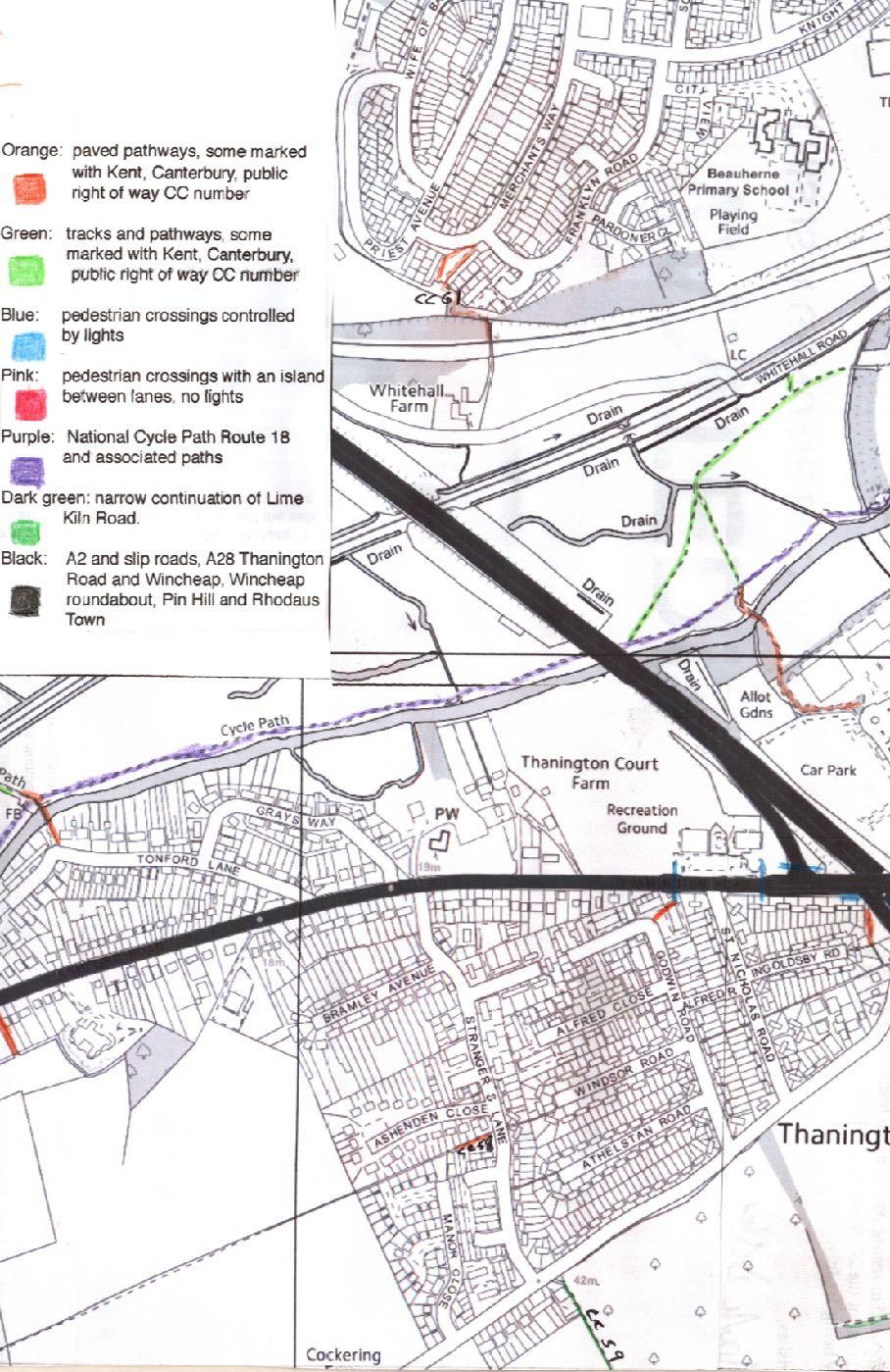
 Canterbury City Council s Plans for new cycle paths Map colour")
2 Contents Introduction: why we wrote this Report Categories of vehicles considered Getting to central Canterbury: Routes under Rheims Way and over Pin Hill Crossing the River Stour to National Cycle Route Path, Route 18 Crossing the A28: cat s cradles of traffic light systems Area map (3 pages) Canterbury City Council s Plans for new cycle paths Map colour codes
3 Introduction: why we wrote this Report Traffic congestion and pollution on Wincheap worsen by the day and parking in the centre becomes increasing difficult and expensive. Residents are exhorted by Canterbury City Council to walk or cycle to and from the city centre, to relieve these problems and to improve their health. The 2011 Census identified 7888 inhabitants of Wincheap ward. An application by a developer to build 750 dwellings in south Thanington has been approved, and application has been made by another developer to build a further 400 dwellings west of that site. How will all these new people get in and out of central Canterbury? Or, as many of them are likely to be commuters, to Canterbury West station to use the high-speed train service to London? How many of them will be elderly? How many disabled? How many with infants in pushchairs? The current bus service from and to Ashford on the A28 is inadequate to the point of invisibility during the day, and does not operate in the evenings or on Sundays. A Park & Ride facility currently is located in the Riverside Retail Park and so does not extend into Thanington, and also does not operate in the evenings or on Sundays. Both these services terminate at Canterbury bus station on the south side of the city, and do not serve Canterbury West station on the north side. Canterbury East train station is located at the east end of Wincheap, offering services to Dover and to Faversham where passengers can connect with the coastal high-speed trains. But for commuters into London changing trains and taking a slower service into London is less attractive than the direct service from Canterbury West. The Wincheap Society decided to look at what routes are available now to people using non-motorised wheeled vehicles to get into the city centre from Thanington and the Wincheap corridor. Oxford, Cambridge, and Amsterdam (indeed all of the Netherlands) are famous for their cycling inhabitants. These cities are very flat: Canterbury is not. The city is flat only along the River Stour valley, where land south of the river slopes down to it gently. Bicycles and similar vehicles should be a favoured alternative to cars in such terrain, and useable by people of all ages and in reasonable health. This report aims to consider use by more than just the young and athletic. The A28 at and from the A2 junction down Wincheap, round the Wincheap Roundabout and on to Pin Hill, and Rheims Way leading into the Wincheap Roundabout are extremely dangerous for bicycles and adult tricycle shoppers. This report assumes that these roads are to be avoided wherever possible.
4 Categories of vehicles considered: 1. Bicycles. 2. Shopper trikes i.e. adult tricycles, back wheels width 73 cm (recliner trikes are not considered for the purpose of this report). Much heavier than bicycles, and very awkward to manoeuvre unless mounted. * 3. Four-wheeled mobility scooters, width 75/100 cm, turning circle 120 cm. (Batteries not classed as motors for the purposes of this Report) * 4. Pushchairs for children. Some of these are very wide. 5. Wheelchairs, whether pushed or propelled by the occupant. * Shopper trikes and mobility scooters are difficult to manoeuvre on staggered mid-lane pedestrian traffic Islands and around off-set tubed metal fencing designed to prevent motor vehicles entering pedestrian and cycle paths. Shopper trikes are favoured by older people because of their stability, but require good road and cycle path surfaces offering three parallel, smooth tracks for their wheels: potholes and ruts can result in dangerous upsets. Cycle paths should be wide enough to allow three- or four-wheeled vehicles (a) to share the width if arriving from opposite directions and (b) not to crowd pedestrians or other vehicles off the path. Regulations including the Highway Code state that categories 1 and 2 should be used only on roads and designated cycle paths. Categories 3, 4 and 5 are to be used on pedestrian pavements and other designated paths, and not on roads. Canterbury s paths and tracks that are not identified as designated cycle paths are intended for use only by pedestrians. Some are merely alleyways and unusable by categories 3, 4 and 5. In this Report we do not advise any breach of regulations. Out on the streets, the law is observed mainly in the breach. We know this. We also know that most people prefer to be law-abiding, unless being so endangers them. Here lies the body of Mike O Day Who died defending his right of way His right was clear, and his will was strong And he s just as dead as if he were wrong.

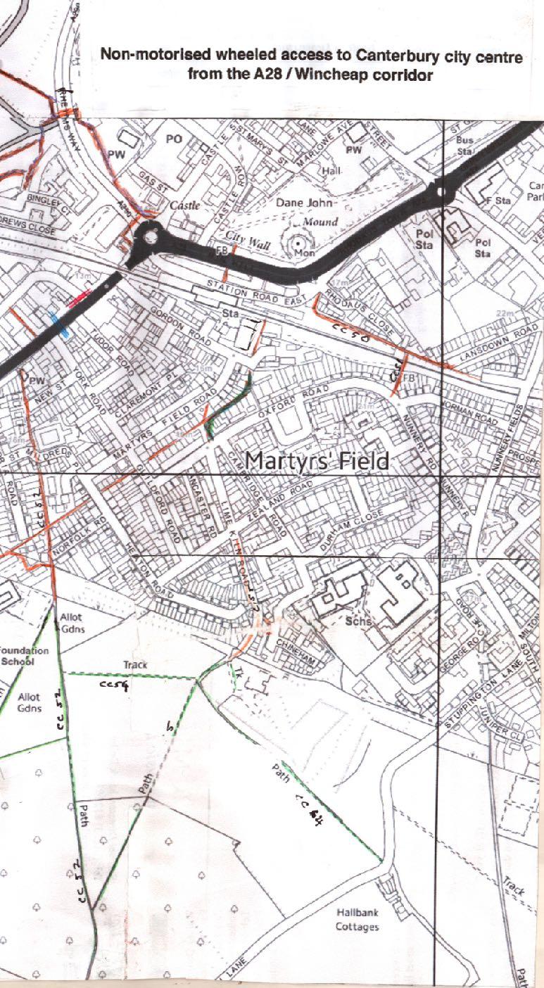
5 Getting to central Canterbury: Routes under Rheims Way and over Pin Hill There are three entry points, but not all useable or convenient for all categories 1 From Bingley Island, Bingley Court and St Andrews Close, over a wooden bridge across the River Stour, to a concreted path on the north side of the underpass beside the river under Rheims Way. The path emerges on the east of Rheims Way with steps up to Rope Walk on the left, or over a wooden footbridge to the right and a sloped path up to Castle Street. Signed Cyclists dismount, so suitable for all five categories but inconvenient for shopper trikes, and access to Rope Walk is only for bicyclists and pedestrians with pushchairs who are prepared to bump up the steps. The underpass path between a wall and the river may be too narrow to allow two wider vehicles to pass without caution. 2 Underpass at the west side of Wincheap roundabout, under Rheims Way. Signed Cyclists dismount, so suitable for all five categories but inconvenient for shopper trikes. East from Wincheap and west from Castle Street approaches by sloping ramps commencing on pedestrian pavements, so bicycles and shopper trikes should be dismounted even before reaching the ramps. 3 Pedestrian path and bridge from Station Road East to the City Wall pedestrian and cycle path and on to the bus station or down the left-hand slope to Castle Row. Signed Cyclists dismount. Suitable for all five categories therefore, but inconvenient for shopper trikes.
6 From the south and west there is no access via Canterbury East Station (except for unencumbered pedestrians who can take the steps down to and up from the tunnel under the tracks, and then only when the gate to the London-bound platform accessed from Gordon Road is unlocked - which it usually is not). Mobility scooters, wheelchairs and pushchairs must approach from Wincheap up Station Road East. Bicycles and shopper trikes are expected to enter Station Road East from Wincheap by circling the Wincheap Roundabout, but this route is very dangerous, so they should dismount and walk their machines along the pedestrian pavement under the railway bridge and then remount when in Station Road East, In Station Road East (which is oneway for motor traffic) there is a contra flow cycle lane which allows cycles to come from Canterbury East Station to Wincheap against the traffic flow 4 Pedestrian bridge between Oxford Road Path (CC51) and Lansdowne Road Path (CC50) then into Station Road East and to the path and bridge to the City Wall. This narrow bridge over the railway is reached by many steep steps at each end. Pushchairs need to be folded up and the child carried. There are grooved narrow ramps for manoeuvring bicycle wheels on the steps at each end. How difficult this may be will depend on the weight of the bike and the strength of the cyclist. Not useable by shopper trikes, mobility scooters or wheelchairs.


7 Crossing the River Stour to National Cycle Route Path, Route 18 1 At the foot of Tonford Lane in Thanington. There is a wide slatted footbridge over the river, approached at each end by several very wide steps leading to National Cycle Path, Route 18. Suitable for bicycles and pedestrians with pushchairs who are prepared bump up and down the steps. Not suitable for shopper trikes, mobility scooters or wheelchairs.
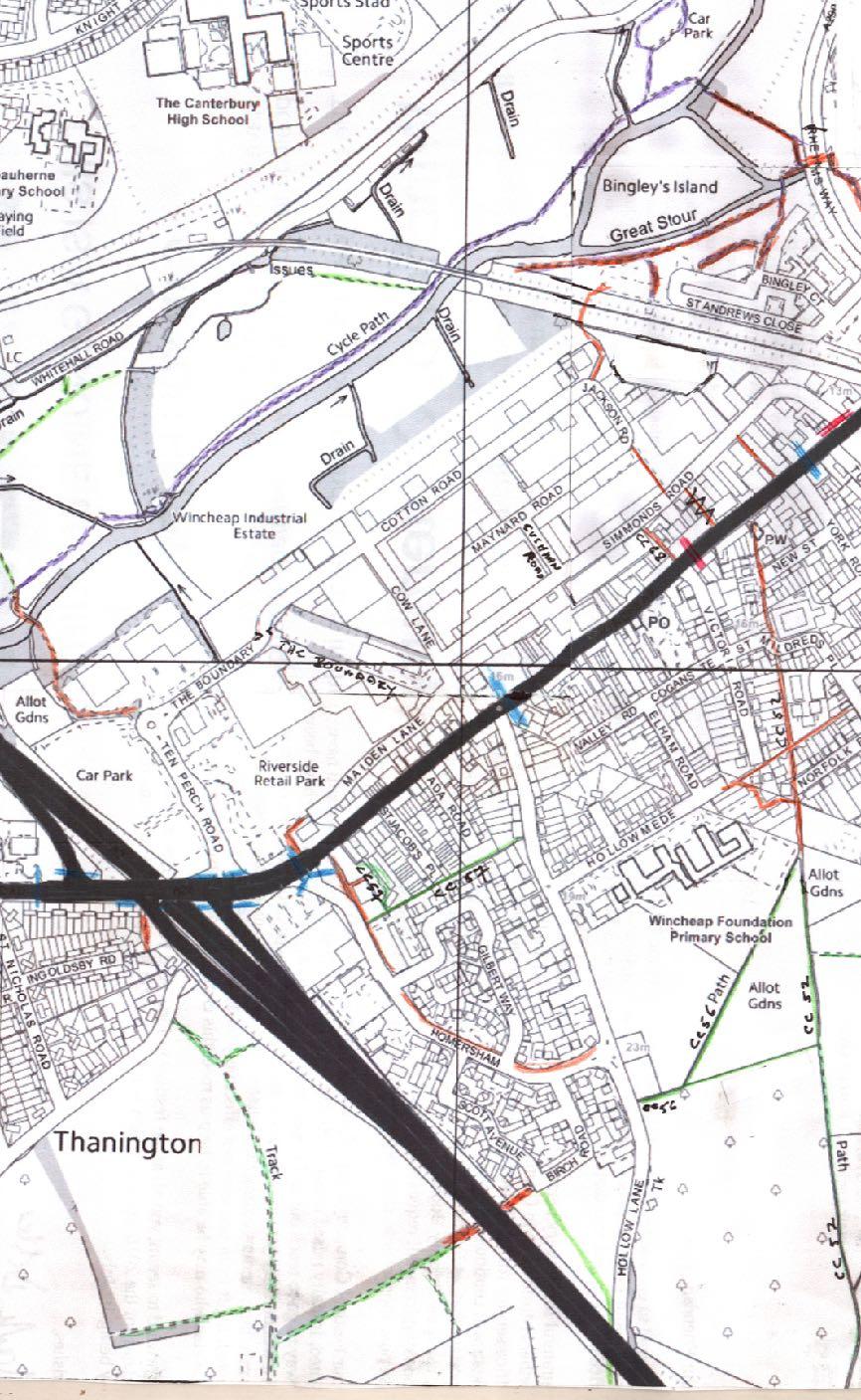
8 2 From the north end of Ten Perch Road. There is a cycle and foot path leading to a bridge across the river and on to National Cycle Path, Route 18, suitable for all five categories. The National Cycle Path does not lead directly to the city centre, but provides access via Westgate Gardens to West Gate and St Dunstan s and on to Canterbury West train station 3 Take the Cotton Road/Jackson Road path ( Horse and Goats Tunnel ) under the railway line to St Andrews Close, across the carpark, cross the footbridge over the river west of Rheims Way, and turn left to the path joining the National Cycle Path. Suitable for all five categories
 near St Nicholas Road.")
9 Crossing the A28: cat s cradles of traffic light systems 1 There are no pedestrian crossings on the western extension of the A28 through Thanington Without until the two traffic light systems each with a staggered central pedestrian island and two sets of pedestrian lights for east- and west-bound traffic, adjacent to the Thanington Recreation Centre (TRC) near St Nicholas Road. These are a long way east of the Tonford Lane footbridge. Suitable for mobility scooters, wheelchairs and pushchairs, but only for bicycles and shopper trikes if the rider dismounts. 2 To reach the path at the north end of Ten Perch Road or the Horses and Goats Tunnel via Jackson Road. If the A28 is crossed from south to north near the TRC, the A2 north-bound slip road must be crossed (pedestrian light). On the eastern side of the A2 bridge, cross the left turning from the A28 into Ten Perch Road, the straight entrance into and exit from Ten Perch Road and the left-turn exit from Ten Perch Road. All three have pedestrian light controls and islands between the lanes. Bicycles and shoppers may choose to enter Ten Perch Road at this point, as do the Park & Ride cars and shuttle buses, and traffic for the Riverside Retail Park. 3 Alternatively, remain on the south side of the A28, cross the A2 north-bound exit (pedestrian lights for left and right turning traffic, pedestrian island between), across the A2 bridge to the A2 south-bound exit (pedestrian lights for traffic entering from the left, straight across from Ten Perch Road and entering from the right (light system, pedestrian island between). Suitable for mobility scooters, wheelchairs and pushchairs, but for bicycles and shopper trikes only if the rider dismounts 4 Moving east from the Ten Perch Road junctions to the traffic light system at the junction of the A28 and Homersham, there are pedestrian crossings for the traffic turns left and the right out of Homersham, and one for the left turn from the A28 into Homersham, all three with pedestrian lights and islands. From the central pedestrian island take the pedestrian crossing over the A28 with a staggered central pedestrian island and two sets of pedestrian lights for east- and west-bound traffic. Suitable for mobility scooters, wheelchairs and pushchairs, but for bicycles and shopper trikes only if the rider dismounts.
10 5 Take the signed pedestrian pathway slightly to the east of the A28/Homersham junction down the slope into Morrison s carpark. Although signed for pedestrians this path appears on a number of cycle way maps as a cycle path. Hypothetically suitable for all five categories. Cross the carpark to the north exit by Morrison s petrol station, turn left into The Boundary, proceed to the north end of Ten Perch Road and onto the path leading to the National Cycle Path. 6 Pedestrian crossing controlled by lights to the east of Cow Lane and Hollow Lane junctions with A28 Wincheap. This gives access from south of Wincheap to Cow Lane and thence to Cotton Road to the Horses and Goats Tunnel, or back west via The Boundary to the north end of Ten Perch Road. Alternatively, a left turn from Cow Lane into Maiden Lane gives access to the pedestrian/cycle path into Morrison s carpark - provided that the door at the western end of Maiden Lane has not been shut and bolted outside trading hours. There is a Public Right of Way CC57 leading from Homersham to the northern end of Hollow Lane, avoiding the polluted A28 road and pedestrian pavement when approaching the Cow Lane junction from the west. However, there are steps at the Hollow Lane end of this path, so it is not useable for shopper trikes, mobility scooters and wheelchairs and, as it is little more than an alleyway, it is not suitable for ridden bicycles.

11 7 Unmarked pedestrian crossing with an island between lanes (no lights) between Victoria Road and Biggleswade Passage south of the A28, giving access to Simmonds Road via path CC68 Coopers Lane beside No 122 Wincheap. The Simmonds Road end of this passage is signed as a pedestrian pathway. Cross Simmonds Road to take Simmonds Road Path to Jackson Road and the Horses and Goats Tunnel. Should be suitable for all categories, BUT On 20th May 2017 we left the following message on KCC s Public Rights of Way website: The surface at the Simmonds Road end of this footpath has been entirely broken up and lifted into house-brick size chunks. Now entirely unsuitable for bikes, wheelchairs, mobility scooters or pushchairs, and almost impassable for pedestrians. It's been in this state for some weeks. (Warning It is feasible to access Simmonds Road from Wincheap via the west side of Elite Garages. However, this is private property and not a public path. There is a red-circled sign on the building with a red diagonal line through a pedestrian figure, and another at the entrance on Simmonds Road.) 8 Pedestrian crossing controlled by lights between York Road and Tudor Road junctions to the south and west of the Simmonds Lane junction with A28 Wincheap. Once across Wincheap turn west to the Spring Gardens pathway and then west again to Simmonds Road Passage, or right to Simmonds Lane and either follow Simmonds Lane to Simmonds Lane Pathway, to Jackson Road and the Horses and Coast Tunnel via Simmonds Road Path. Or, cross the Simmonds Road junction with A28 Wincheap (without lights, central pedestrian island) and continue on the pedestrian pavement to the Wincheap underpass. Suitable for all categories, provided bicycles and shopper trikes are dismounted on pedestrian pavements. The pedestrian pavement on the north side of Wincheap, east of the railway bridge outside Coombs Ltd, slopes sideways towards the roadway, is in poor repair, and is hazardous for both pedestrians and wheeled vehicles.
12
13
14

15 Canterbury City Council s Plans for new cycle paths For a CCC map: and search for proposed cycle routes. 1 Wincheap to South Canterbury Including Public Right of Way CC56 from its junction with CC52 to Hollow Lane to be upgraded to a cycle path, and Public Right of Way CC52 from Hollowmede to its junction with CC54, and CC54 to its junction with CC55 to be upgraded to cycle paths. Estimated cost: 100,000. Comment Pentland Homes Ltd currently are building 52 dwellings between Hollow Lane and CC56 where it extends west of an allotments area. Planning permission was awarded with a condition that PHL preserves and enhances CC56, so presumably PHL will contribute to all or part of the 100,000. On 13th May 2017 we left the following message on KCC s Public Rights of Way website: At the point where CC56 turns into the orchard and towards Hollow Lane there is a fence across it: paling, heavy wire and barbed wire. The lower and middle wires have been bent back to get access, but the upper wire and a strand of barbed wire above it remain, at about eye height on an adult, necessitating people to crouch down to get through the narrow gap. The north-east / south-west section of CC56 nearly is not being used as much as formerly: vegetation is beginning to impinge, and there is "weathered" litter along the path. Query: when building by Pentland Homes is completed, will the east-west section of CC56 lie alongside the new estate boundary, or will it continue to run through the orchard?
16 2 Thanington to Hollow Lane. To provide a mainly off-road alternative to the A28 and link two large residential areas. Estimated cost: 50,000. This utilises the farmers underpass under the A2 at Birch Road. The CCC map marks to be upgraded rough tracks west of the underpass. It also appears to incorporate Hollow Lane from the Homersham junction north to the Hollowmede. Comment These same tracks are marked as cycle paths on Pentland Properties Ltd s plan for Thanington Park, so presumably PPL will bear the entirety of that cost. East of the underpass Birch Road (which is partly pedestrianised and borders a park with a children s play area) joins Homersham just west of its junction with Hollow Lane. The roundabout at this point has been enlarged and enhanced to deal with traffic from Pentland Homes Ltd s development. Public right of Way CC56 joins Hollow Lane just north of the roundabout, quite literally through a hedge. It is impossible for drivers to see walkers, or walkers to see traffic, until walkers are actually on the roadway. Perhaps some of the 50,000 could be used to make this junction safe. Comment No part of Hollow Lane is suitable as a bicycle or shopper tricycle route. It is narrow for all its length. North of the Hollowmede junction, it is bordered by terraced houses and residents cars parked on the west side. Between Hollowmede and the junction with Homersham, the surface is badly potholed. Cars are parked on the west side (particularly when lessons at Wincheap Foundation Primary School are starting or finishing) so that it is often difficult for cars from opposite directions to pass, and there is no pedestrian pathway on the east side (and PPL has not been required to provide one) so pedestrians with or without pushchairs, mobility scooters, and wheelchairs cross from east to west all along this section. South of the Homersham junction it is a winding and overshadowed country lane with no footpaths on either side and very limited sight lines. 3 Wincheap to Canterbury East Railway Station. From Oxford Road, north-east along Lime Kiln Road to the east end of Gordon Road. This would provide pedestrian and cycle access from the south side of the railway station. The train operating company will be encouraged to open up the gated access to the London bound platform. Estimated cost: 30,000. Comment: This enhancement to the cycle path will not facilitate access to the bridge across Pin Hill for any of the categories of vehicles under consideration in this report. Comment: Currently this is a narrow, winding section of Lime Kiln Road between private properties, and used by motor traffic (including HGVs), cycles and pedestrians. The sight-lines are limited It is difficult to see what the 30,000 can spent on. Perhaps on the path and part cycle route running straight from the east end of Hollowmede along back alleys and garage-access roads to join Lime Kiln Road where it turns at Martyrs Field? This path is badly potholed and uneven. The section between Heaton Road and Guildford Road is unlit at night, which makes both walking and cycling very hazardous. To view current public rights of way mentioned here: and search for public rights of way, then click on rights of way map ; enlarge the Canterbury section of the map, and search on the left hand menu by the CC number.
The Wincheap Society
 The Wincheap Society s on sections of: Thanington 4th Arm Slip Road, Walking, Cycling & Horse-Riding Assessment & Review Report, by Peter Brett Associates, October 2017, on behalf of Pentland Properties
Drawing 5269/GA01: A2/A28 Coast bound off-slip - Wincheap Scheme
 Drawing 5269/GA01: A2/A28 Coast bound off-slip - Wincheap Scheme Notes and queries by the Wincheap Society, May 2017 Comments 1 Off the A2: Approaching the A28 junction from the north, new slip road marked
Bulwell Cycling Consultation
 Bulwell Cycling Consultation Image 1 Bulwell Bogs (Sutton, 2015) As part of a final year research project, I am seeking feedback on proposals for cycling improvements in Bulwell. This consultation is not
Signs. signs, signals and road markings. in this chapter
 3 signs, signals and road markings in this chapter Signs regulatory signs school, playground and crosswalk signs lane use signs turn control signs parking signs reserved lane signs warning signs object
Chapter 4 Route Window C3 Hyde Park and Park Lane shafts. Transport for London
 Chapter 4 Route Window C3 Hyde Park and Park Lane shafts Transport for London HYDE PARK AND PARK LANE SHAFTS 4 Route Window C3 Hyde Park and Park Lane shafts Introduction 4.1 In this route window, which
Public Consultation on Braintree Integrated Transport Package (ITP) HAVE YOUR. Consultation open from 24 September to 5 November 2018 SAY
 HAVE YOUR. Consultation open from 24 September to 5 November 2018 SAY") Public Consultation on Braintree Integrated Transport Package (ITP) HAVE YOUR SAY Consultation open from 24 September to 5 November 2018 Contents Introduction 3 Background 4 Springwood Drive Roundabout
Public Consultation on Braintree Integrated Transport Package (ITP) HAVE YOUR SAY Consultation open from 24 September to 5 November 2018 Contents Introduction 3 Background 4 Springwood Drive Roundabout
Copenhagen Cycling Map. Red Lines Cycling facilities
 Copenhagen Cycling Map Red Lines Cycling facilities Copenhagen Cycling Facilities Design Approaches Transportation without Pollution Copenhagen s Strategy Where Cycling is one of the top key activities
Improving Thetford Cycling Provision. In and Around Thetford
 Improving Cycling Provision In and Around Thetford Presentation to Thetford Town Council July 2015 About Me Lecturer in Mathematics at the University of East Anglia Keen recreational cyclist Volunteer
01. VICINITY OF GREENBRAE POC: EXISTING CONDITIONS
 01. VICINITY OF GREENBRAE POC: EXISTING CONDITIONS Existing Bus Stop Existing US101 On-ramp Existing POC Old Redwood Highway Rich Street City ROW Environmental Study Limit Industrial Way NO DESIGNATED
General Design Factors
 Chapter 3: 3-1.0 Introduction General Design Factors Mn/DOT s goals include encouraging and accommodating safe bicycling. From a design perspective, these goals are achieved by first having an understanding
The Wincheap Society s comments on, and objections to, CA//17/02718
 To: Canterbury City Council Planning Department [Letter dated] 30 December 2017 The Wincheap Society s comments on, and objections to, CA//17/02718. The document that accompanies this letter contains our
Report from Embassy Visit to Copenhagen May David Arditti
 Report from Embassy Visit to Copenhagen May 2013 David Arditti Standard CPH cycle track, one-way 1.5 2m wide, 5cm above carriageway, 5cm below footway Basic one-way cycle track protected by car parking
Chapter 3 DESIGN SPECIFICATIONS
 Brampton PathWays Planning and Design Guidelines 27 Chapter 3 DESIGN SPECIFICATIONS 3.1 CLASS 1 MULTI-USE PATH Off-road multi-use trails are the backbone of the Brampton PathWays Network. They are typically
Submission on Clontarf to City Centre Cycle Route with signatures of 1,493 people
 Submission on Clontarf to City Centre Cycle Route with signatures of 1,493 people Route should use a fully segregated two-way cycle path Contact details Cian Ginty - editor, IrishCycle.com - cian.ginty@gmail.com
Ballston Station Multimodal Study WMATA and Arlington County. Meeting Minutes
 Date of Meeting: June 10, 2010 Location: Ballston Metrorail Station and NRECA Building 4301 Wilson Blvd, Arlington, VA Subject: Ballston Station Multimodal Study Stakeholder Meeting #1 Summary: This first
Neighbourhood Development Plan: Ashtead INTRODUCTION 2 SUMMARY CONCLUSION CAR USE AND CONGESTION IN ASHTEAD 4
 CONTENTS Page INTRODUCTION 2 SUMMARY CONCLUSION 3 1.0 CAR USE AND CONGESTION IN ASHTEAD 4 1.1 Car Ownership and Methods of Travel to Work 4 1.2 Traffic Congestion in Ashtead 4 2.0 PARKING FACILITIES AND
Derby Cycling Group, c/o 126, Station road, Mickleover, Derby, DE3 9FN. Date: 20 th November, 2018.
 Your Ref: Derby City Council Air Quality - Preferred Option Nov 2018 Derby Cycling Group, c/o 126, Station road, Mickleover, Derby, DE3 9FN Date: 20 th November, 2018. 1. Introduction: 1.1. Derby Cycling
High frequency bus services operating to Little Island; Creation of a new Park and Ride site and train station at North Esk;
 Cork County Council 7 th December 2018 Dear Adrian O Neill (aoneill@jbbarry.ie) The Transport and Mobility Forum, Cork (TMF) is a representative group of organisations who have a common interest in sustainable
RAILWAY SAFETY. Please click on any of the links below to go directly to your specified topic within this document.
 RAILWAY SAFETY Please click on any of the links below to go directly to your specified topic within this document. Facts about Railway Property and Trains Railway Signs, Devices, and Warnings Railway Safety
Guide to the Cycle Enfield Public Consultation on Enfield Town. Produced by the Save Our Enfield Town Campaign Group
 Guide to the Cycle Enfield Public Consultation on Enfield Town Produced by the Save Our Enfield Town Campaign Group What s in this guide? Introduction Page 3 What Enfield Council says about Option 1 Page
Regulatory traffic signs
 Section 21: Regulatory traffic signs This section includes the signs that show a road regulation is in place. These must be obeyed. Regulatory signs show the course a driver must follow and an action they
THE CORPORATION OF THE CITY OF BELLEVILLE BY-LAW NUMBER
 THE CORPORATION OF THE CITY OF BELLEVILLE BY-LAW NUMBER 2017-146 A BY-LAW TO REGULATE BICYCLES, SKATEBOARDS, IN-LINE SKATES, ROLLER SKATES, E- BIKES, SEGWAYS AND OTHER CONVEYANCES DRAWN, PROPELLED OR DRIVEN
What is the status of the CPR Yards Crossing Study?
 September 2015 Project Advisory Committee (PAC) Sectors RESIDENTS Centennial Community Improvement Association Dufferin Residents Association of Winnipeg William Whyte Residents Association LOCAL BUSINESS
Parental Responsibilities
 Bicycle riding is a fun way to exercise and enjoy the outdoors. To remain safe on Illinois roads, bicyclists must obey the same traffic safety laws that govern vehicle drivers. No amount of bicycle safety
SANDGATE PRIMARY SCHOOL Updated School Travel Plan January 2017
 SANDGATE PRIMARY SCHOOL Updated School Travel Plan January 2017 (Original Plan completed January 2006) DCSF No. 886/2545 School Travel Planner: Beverley Thompson School Business Manager beverley.thompson@sandgate.kent.sch.uk
Unit Five : Driving In Neighborhoods
 Unit Five : Driving In Neighborhoods What Are We Going To Do Today? Students will be able to describe the skills necessary to How safely and do legally you make drive in a residential How do area. you
European Student Competition VOICE Vulnerable Road Users Organizations in Cooperation Across Europe
 European Student Competition VOICE Vulnerable Road Users Organizations in Cooperation Across Europe Name of task: Modernization of Grochowska street in Warsaw Area of Grochowska and Minska crossroad Full
BEST PRACTICES FOR ACCESSIBLE TRANSPORT. C G B (Kit) Mitchell
 Mitchell") BEST PRACTICES FOR ACCESSIBLE TRANSPORT by C G B (Kit) Mitchell Independent mobility is necessary for independent living Many people with disabilities use cars, either as driver or passenger Those who
BEST PRACTICES FOR ACCESSIBLE TRANSPORT by C G B (Kit) Mitchell Independent mobility is necessary for independent living Many people with disabilities use cars, either as driver or passenger Those who
Vermont Permit Test Flash Cards
 Vermont Permit Test Flash Cards Study online at quizlet.com/_aormb are the most likely places for car and motorcycle collisions to occur. intersections are areas around trucks where cars disappear 2. :
SHOTLEY BRIDGE VILLAGE TRUST
 SHOTLEY BRIDGE VILLAGE TRUST Traffic & Parking Study - 2009 The Parking Lot, a focus group of the Shotley Bridge Village Trust, has undertaken this study. Evidence was gathered, through surveys during
SITE OBSERVATION FORM
 Sequential # Site ID: Sequential Number in pencil Injury Site B. Additional Site D. Additional Site E. Site type will be completed by the Study Coordinator after the Observation Form is completed. SITE
Non-Motorized Transportation 7-1
 Non-Motorized Transportation 7-1 Transportation facilities no longer mean just accommodating a vehicle powered by a combustion engine. Pedestrian and non-motorized facilities are important modes of travel
HISTON ROAD Have your say on better public transport, cycling and walking journeys
 HISTON ROAD Have your say on better public transport, cycling and walking journeys Have your say: Please complete the survey inside this leaflet or online at www.greatercambridge.org.uk/histonconsultation
Saturday 3 November 2018 City Race Euro Tour Offerton Sprint. The Important Stuff - If you don t read anything else, read this!
 Saturday 3 November 2018 City Race Euro Tour Offerton Sprint The Important Stuff - If you don t read anything else, read this! Do NOT cross the boundaries or enter or attempt to cross terrain areas shown
CHECKLIST 2: PRELIMINARY DESIGN STAGE AUDIT
 CHECKLIST 2: PRELIMINARY DESIGN STAGE AUDIT 2.1 General topics 2.1.1 Changes since previous audit Do the conditions for which the scheme was originally designed still apply? (for example, no changes to
Chelmsford City Growth Package
 Chelmsford City Growth Package Public Consultation Document Volume 2 West Chelmsford July - August 2017 Chelmsford City Growth Package Public Consultation Document - Volume 2 - West Chelmsford Contents
Road Traffic Signs in Germany
 Warning signs Road Traffic Signs in Germany General danger Curve left Curve right Double curve Double curve Accident hazard Sliding danger Winter sports along road Soft shoulder Rough road edge Steep upgrade
Heartwood Forest, in Sandridge, Hertfordshire, is a place where everyone can find space, peace, wildlife and miles of beautiful woodland to explore.
 Heartwood Forest Accessibility Statement September 2016 Purpose: This accessibility statement outlines the available facilities and access information for Heartwood Forest. Welcome We, the Woodland Trust,
MARKHOUSE ROAD IMPROVEMENTS
 MARKHOUSE ROAD IMPROVEMENTS www.enjoywalthamforest.co.uk Waltham Forest is changing and we want you to be part of it. Thanks to a funding pot of 27million from Transport for London, we re delivering the
Tonight is for you. Learn everything you can. Share all your ideas.
 Strathcona Neighbourhood Renewal Draft Concept Design Tonight is for you. Learn everything you can. Share all your ideas. What is Neighbourhood Renewal? Creating a design with you for your neighbourhood.
Controlled. Semi-Controlled PAGE 01 CHAPTER 12 INTERSECTIONS
 PAGE 01 CHAPTER 12 INTERSECTIONS You will cross many intersections while driving. Intersections are especially dangerous because vehicles are crossing each other s driving path. Many crashes happen at
Rhebogue Neighbourhood Greenway. Road Safety Audit Stage 2
 Rhebogue Neighbourhood Greenway Road Safety Audit Stage 2 Report Number: 12/007/00/00057 July 2014 Mid West National Road Design Office Lissanalta House, Dooradoyle County Limerick Tel: 061 496 800 Fax:
Devonport City Cycling Network Strategy
 Devonport City Cycling Network Strategy 2010-2013 Devonport City Cycling Network Strategy Introduction In February 2010 a draft master plan for cycleways was presented to the community. The feedback received
Background. Caversham a vision for the future. Joint public meeting arranged by:
 Joint public meeting arranged by: Sharing our Streets Caversham a vision for the future and Caversham Traders Association This presentation followed a presentation by Simon Beasley, Network Manager for
ACV Community Engagement Feb/Mar 2015: Summary (Infrastructure issues highlighted in red)
") Ashtead Choral Society Best answer: Nothing (a follow up spoken comment was that it s just right Transport A solution to end the on street parking in Craddocks Parade area and surrounding roads. Traffic
Ashtead Choral Society Best answer: Nothing (a follow up spoken comment was that it s just right Transport A solution to end the on street parking in Craddocks Parade area and surrounding roads. Traffic
2015 Hertfordshire Triathlon Summer Sunday 30 th August
 Dear Race Entrant, Race Details This is your race information pack for the Hertfordshire Triathlon Summer and the Hetfordshire Triathlon Club Champs. ActiveTrainingWorld would like to thank Triathlon Zone,
National Cycle Network Route 81 Wolverhampton Cross City Route August 2005
 Page 12 Buses often stop in Lichfield Street and there is no space to pass. Should an NCN route be following a road which is heavily congested with buses and diesel fumes? 14. Railway Drive The dropped
The Hundred Parishes
 The Hundred Parishes Walks from railway stations number 9 6.4 miles (10kms) from Bishop s Stortford to Stansted Mountfitchet Start: Bishop s Stortford station (Grid Reference TL492209) (ample parking and
The Mendip Way. Route Directions and Maps Wells to Frome
 The Mendip Way Route Directions and Maps Wells to Frome Website: www.mendiphillsaonb.org.uk Email: mendip@mendiphillsaonb.org.uk Facebook & Twitter: @MendipHillsAONB Phone: 01761462338 1 Wells to Shepton
ON ROAD CYCLE TRAINING
 ON ROAD CYCLE TRAINING A guide to safer cycling On road cycle training A guide to safer cycling 4 5 6 7 8 9 0 4 5 Starting and finishing a journey Road positioning Passing parked and slower vehicles Passing
2016 Hertfordshire Triathlon Spring Sunday 28 th August
 Dear Race Entrant, Race Details This is your race information pack for the Hertfordshire Triathlon Spring and the Hertfordshire Triathlon Club Champs. ActiveTrainingWorld would like to thank Moveology,
THE PROPOSED NETWORK RAIL (ESSEX AND OTHERS LEVEL CROSSING REDUCTION) ORDER DEPARTMENT FOR TRANSPORT REFERENCE: TWA/17/APP/05
 ORDER DEPARTMENT FOR TRANSPORT REFERENCE: TWA/17/APP/05") OBJ/148/W 005 E05 CROSSING, FULLERS END THE PROPOSED NETWORK RAIL (ESSEX AND OTHERS LEVEL CROSSING REDUCTION) ORDER PUBLIC INQUIRY, 18 OCTOBER 2017 DEPARTMENT FOR TRANSPORT REFERENCE: TWA/17/APP/05 OBJECTION
OBJ/148/W 005 E05 CROSSING, FULLERS END THE PROPOSED NETWORK RAIL (ESSEX AND OTHERS LEVEL CROSSING REDUCTION) ORDER PUBLIC INQUIRY, 18 OCTOBER 2017 DEPARTMENT FOR TRANSPORT REFERENCE: TWA/17/APP/05 OBJECTION
OLDER PEOPLE INDEPENDENT MOBILITY FOR LIVEABLE COMMUNITIES. Christopher G B (Kit) Mitchell
 Mitchell") OLDER PEOPLE INDEPENDENT MOBILITY FOR LIVEABLE COMMUNITIES by Christopher G B (Kit) Mitchell Independent mobility is necessary for a high quality of adult life In developed countries, the automobile has
OLDER PEOPLE INDEPENDENT MOBILITY FOR LIVEABLE COMMUNITIES by Christopher G B (Kit) Mitchell Independent mobility is necessary for a high quality of adult life In developed countries, the automobile has
Mobility Scooter Challenges
 Mobility Scooter Challenges to accessibility in Sooke A Mini-AWARENESS Campaign Sooke, BC By Carol Mallett & Bill Jones February 10, 2015 Mobility Scooters DEFINITION A mobility scooter is an amazingly
Angel Drove carpark 3/day
 GETTING TO ELY ( A on the map below marks the city centre; for a larger scale see the map at the end of the directions, where there are also details of car parking and pedestrian access to the venue) Angel
THE ROAD TO LONDON From Roman Baldock From Medieval Baldock From Tudor Baldock
 THE ROAD TO LONDON What would you say if I stopped you in the street and asked you the way to London? You d probably direct me to the roundabout by Tesco s, tell me to go up the hill along London Road
2014/2015 BIKE ROUTE PLAN 83 AVENUE PROTECTED BIKE LANE
 About the Project 2014/2015 BIKE ROUTE PLAN The City of Edmonton is planning a major bike route on the south side of Edmonton. This bike route is one part of a plan to provide citizens with transportation
Thanington 4 th Arm Slip Road
 Walking, Cycling & Horse-Riding Assessment & Review Report On behalf of Pentland Properties Project Ref: 39183/2001 Rev: 1 Date: October 2017 Office Address: Calgarth House, 39-41 Bank Street, Ashford
LOCAL CIRCUIT EM1: EAST MALLING & BARMING HEATH. N 2m ROADS: Significant roads PATHS: Starting direction Barming Longsole Mission Church
 Ditton Church Scott Close LOCAL CIRCUIT EM1: EAST MALLING & BARMING HEATH 6 Community Centre F Open fields (see 'Introductory Notes') 1m 88 Direction label (as in the walk notes) East Malling Church -
ACCESSIBLE LOADING ZONES AND PROTECTED BIKE LANES: A UNIVERSAL DESIGN APPROACH. Accessibility Coalition Dec. 2016
 ACCESSIBLE LOADING ZONES AND PROTECTED BIKE LANES: A UNIVERSAL DESIGN APPROACH Accessibility Coalition Dec. 2016 A myth exists that only able-bodied individuals can ride bicycles. In reality, people with
LEA BRIDGE ROAD - A STREET FOR EVERYONE Public consultation document
 LEA BRIDGE ROAD - A STREET FOR EVERYONE Public consultation document TELL US Bakers Arms to Leyton Green Road (Section D, E, F) Leyton Green Road to Whipps Cross Roundabout (Section G) YOUR VIEWS www.enjoywalthamforest.co.uk
Frome Street Bicycle Route
 The Adelaide City Council invites engagement from the community about Frome Street Bicycle Route Project Summary Adelaide City Council is seeking feedback on design options to construct bicycle facilities
Creating walkable, bikeable and transit-supportive communities in Halton
 Creating walkable, bikeable and transit-supportive communities in Halton By presenting current research and best practices, the information in this paper is meant to support and broaden discussion on how
The plan should be reviewed periodically i.e. each term in a school, following incidents or at least annually on other sites.
 Schools and Children s Services Sites Traffic Management Plan Guidance This guidance has been produced to assist headteachers and managers of LCC premises to identify and control the risks associated with
Signage and condition of road and pavements on both sides of Chesil Street
 Signage and condition of road and pavements on both sides of Chesil Street Tuesday 26 July and Tuesday 2nd August 2016, both at 6 p.m. Audited by: Janet Berry, Angela Stevenson, Mike Slinn, Phil Gagg,
SEA LIFE Brighton: Access Statement May 2015
 SEA LIFE Brighton: Access Statement May 2015 INTRODUCTION The SEA LIFE Centre is situated in the heart of Brighton right next to Brighton Pier. It can be seen from the main route into Brighton; London
TS 109 DURHAM ROAD QTC PHASE 4 PROJECT PROPOSAL. Page 1
 TS 109 DURHAM ROAD QTC PHASE 4 PROJECT PROPOSAL Page 1 Table of Contents 1.0 Introduction... 3 2.0 Project Overview... 3 3.0 Project Proposals... 4 3.1 Enfield Road / Durham Road Junction... 3 5 3.2 Summerfield
Kingswood Primary School s Travel Plan
 Kingswood Primary School s Travel Plan Kingswood Primary School Cayser Drive Kingswood Maidstone Kent ME17 3QF 01622 842674 DCSF number 886-2578 Travel Plan Co-ordinator- Darren Waters ( headofschool@kingswood.kent.sch.uk)
PAGHAM NEIGHBOURHOOD PLAN INFRASTRUCTURE GROUP
 PAGHAM NEIGHBOURHOOD PLAN INFRASTRUCTURE GROUP SUMMARY OF FINDINGS AND PRIORITIES PARKING There was a high level of response to this topic which included many aspirations to provide car parking near to
CHECKLIST 5: ROADWORK TRAFFIC SCHEME AUDIT
 CHECKLIST 5: ROADWORK TRAFFIC SCHEME AUDIT 5.1 General items 5.1.1 Alignment Are the roadworks located safely with respect to horizontal and vertical alignment? If not, does works signing cater for this?
ECONOMY PEOPLE ENVIRONMENT
 Report Back on Local Transit Improvements May 29, 2013 ECONOMY PEOPLE ENVIRONMENT Intro Council Requested Report Back Topics Progress on Planning for Broadway Subway False Creek Bridges Local Transit Improvements
laws AnD rules of the road ight-of-way rules General Information Respect Respecting respect Pedestrians Important:
 LAWS AND RULES OF THE ROAD Right-of-Way Rules General Information Right-of-way rules, together with courtesy and common sense, help to promote traffic safety. It is important to respect the right-of-way
A future cycle route network for North Staffordshire mb/08/16 Need for a strategy. Existing cycle route network
 Need for a strategy 1. The government s aim is to double cycling levels nationally by 2025 [note 1]. This would bring significant health, environmental, economic and traffic benefits [note 2]. It is widely
DESIGN CODE. Enterprise West Harlow London Road North Design Code 21
 DESIGN CODE Enterprise West Essex @ Harlow London Road North Design Code 21 4 MAXIMUM BUILDING HEIGHTS 4.1 Table 4A sets out maximum building height standards for each character area within the LDO boundary.
Dorridge & District Residents Association A Walk Along The Green Belt From Dorridge to Catherine-de-Barnes
 Dorridge & District Residents Association A Walk Along The Green Belt From Dorridge to Carine-de-Barnes The starting section of this walk through open fields would be destroyed by building of motorway
Your Safety is Important
 Your Safety is Important This booklet gives road safety advice to users of Mobility Scooters. These can have three or four wheels and must not travel at more than 10km per hour on level ground, with a
Traffic signs used, including signs giving orders, warning signs, direction signs, information signs and road works signs.
 Traffic signs Traffic signs used, including signs giving orders, warning signs, direction signs, information signs and road works signs. Although The Highway Code shows many of the signs commonly in use,
Bedfordshire County Council Cycle Parking Guidance Annex 1 Development standards Annex 2 Parking dimensions and layouts
 Bedfordshire County Council Cycle Parking Guidance Annex 1 Development standards Annex 2 Parking dimensions and layouts Page 1 of 10 August 2006 Annex 1 Development standards Developers should supply the
Traffic Signs and Signals
 CHAPTER FOUR Traffic Signs and Signals Traffic signs control traffic flow, making streets and highways safer for drivers, bicyclists and pedestrians. These signs, which are posted by the Indiana Department
The Cabinet Member for Highways & Streetscene. Aurang Zeb - Head of Highways & Transport
 LONDON BOROUGH OF RICHMOND UPON THAMES Cabinet Member Decision DATE: January 2012 REPORT OF: LEAD OFFICER: SUBJECT: WARDS: The Cabinet Member for Highways & Streetscene Aurang Zeb - Head of Highways &
T R A F F I C S K IL L S 101
 page 1/5 GENERAL INSTRUCTIONS Mark your answers on the answer sheet provided. DO NOT make any marks on the test. Please read the following definitions and assumptions carefully before answering the test
Nottingham Cycle City Frequently Asked Questions
 Nottingham Cycle City Frequently Asked Questions About the scheme How much money is to be spent on cycling? And where is the money from? We have 6.1 million in Growth Fund which we will be investing directly
Bicycle and Pedestrian Facilities Toolbox (Excerpt from Figure 3.1)
") Appendix B Neighborhood Connections Summaries This Appendix is a supplement to the information presented in Chapter 3 Connect People. The Appendix includes a summary or profile for each of the proposed
Appendix B Neighborhood Connections Summaries This Appendix is a supplement to the information presented in Chapter 3 Connect People. The Appendix includes a summary or profile for each of the proposed
What Is a Complete Street?
 Session 5 Charleen Zimmer, AICP, Zan Associates May 5-7, 2010 What Is a Complete Street? May 2010 5-1 Not a Complete Street More of a Complete Street May 2010 5-2 Benefits of Complete Streets Safety for
A127/A130 Fairglen Interchange Improvement Schemes. Information Leaflet February 2017
 A127/A130 Fairglen Interchange Improvement Schemes Information Leaflet February 2017 1 2 Foreword By Councillor Kevin Bentley Essex is continuing to grow as a vibrant economic hub and as a fantastic place
Side Roads and Other Non-Signalised Junctions
 Green Surfacing Sections of the Cycle Superhighway are marked with green paint these highlight sections where people cycling the Superhighway are likely to come into contact with walkers, drivers, or other
City of Coronado Bicycle Map, Schools, Traffic Signals and Crossing Guard Locations
 City of Coronado Bicycle Map, Schools, Traffic Signals and Crossing Guard Locations Early Childhood Development Center Crossing Guard - AM Crossing Guard - PM Coronado Middle Village Elementary Coronado
Maynooth Cycling Submission on North South Corridor
 Maynooth Cycling Submission on North South Corridor Maynooth Cycling welcomes the intention to improve facilities and quality of service for pedestrians and cyclists in Maynooth. In particular, we strongly
CURBSIDE ACTIVITY DESIGN
 5 CURBSIDE ACTIVITY DESIGN This chapter provides design guidance for separated bike lanes adjacent to curbside activities including parking, loading and bus stops. Typical configurations are presented
Road Markings. Lecture Notes in Transportation Systems Engineering. Prof. Tom V. Mathew
 Road Markings Lecture Notes in Transportation Systems Engineering Prof. Tom V. Mathew 1 Overview The essential purpose of road markings is to guide and control traffic on a highway. They supplement the
Footpath design. A guide to creating footpaths that are safe, comfortable, and easy to use
 Footpath design A guide to creating footpaths that are safe, comfortable, and easy to use November 2013 Contents Introduction / 1 Zoning system / 2 Width / 4 Height / 5 Surface / 5 Footpath elements /
Sandyford Cycle Route (Kilgobbin / Drummartin Link Road)
") Sandyford Cycle Route (Kilgobbin / Drummartin Link Road) Public Consultation Report on Submissions Client: Dun Laoghaire-Rathdown County Council Date: May 2018 Job Number: 15_116B Clifton Scannell Emerson
Sandyford Cycle Route (Kilgobbin / Drummartin Link Road) Public Consultation Report on Submissions Client: Dun Laoghaire-Rathdown County Council Date: May 2018 Job Number: 15_116B Clifton Scannell Emerson
Improving Cyclist Safety at the Dundas Street West and Sterling Road Intersection
 STAFF REPORT ACTION REQUIRED Improving Cyclist Safety at the Dundas Street West and Sterling Road Intersection Date: August 17, 2012 To: From: Wards: Reference Number: Public Works and Infrastructure Committee
North Buckhead Civic Association. Recommendations For Wieuca Road
 North Buckhead Civic Association Recommendations For Wieuca Road October 7, 2009 Blank Page Page 2 of 16 Table of Contents 1. BACKGROUND 4 2. TRAFFIC SIGNALS AND ALL WAY STOPS 5 3. SPEED LIMITS AND SPEED
1 st and 2 nd Street Couplet FAQ s
 1 st and 2 nd Street Couplet FAQ s Q. Will the proposed roundabout at Flume/2nd/1 st Streets affect access to businesses nearby?... 2 Q. What if the project isn t received well by the community after construction?...
5 CIRCULATION AND STREET DESIGN
 5 CIRCULATION AND STREET DESIGN This chapter describes circulation and streetscape improvements proposed for the Northwest Chico Specific Plan Area. It includes detailed design specifications for existing
St Peter s Catholic Primary School ACTIVE TRAVEL POLICY
 St Peter s Catholic Primary School ACTIVE TRAVEL POLICY Information for Parents/Carers about travelling to and from school We are aware that travel to and from St Peter s can be challenging at times. We
Martlesham Heath: January 23 rd 2014
 Public meetings - Roads & Transport responses Three public meeting were held in which members of the public were invited to give their views. This document contains the comments received. For each meeting
The Colchester Orbital Project Obstacle Audit (barriers to access on the Orbital)
") The Colchester Orbital Project Obstacle Audit (barriers to access on the Orbital) (Autumn 2016) The Orbital map can be seen here: The Colchester Orbital Online Map (obstacles indicated in red) Explanatory
The Colchester Orbital Project Obstacle Audit (barriers to access on the Orbital) (Autumn 2016) The Orbital map can be seen here: The Colchester Orbital Online Map (obstacles indicated in red) Explanatory
Walking Audit Supporting Information
 Walking Audit Supporting Information Planning to do a walking audit of your streets? Here s some helpful suggestions to help get you started. 1. Preparing for your audit Decide where you want to walk.