7 NE 145TH STREET STATION TOD POTENTIAL
|
|
|
- Jemima Snow
- 5 years ago
- Views:
Transcription
1 7 NE 145TH STREET STATION TOD POTENTIAL Key Findings The 145th Street Station area has limited TOD potential, primarily because of its location in an area that is currently zoned predominantly single-family residential. With a public golf course occupying over 20 percent of the station area and rights-of-way occupying 24 percent of the station area, redevelopment in this area is unlikely to be significant enough to support a transitoriented community. The City of Shoreline Comprehensive Plan includes new goals and policies aimed at redevelopment near the proposed station. In the future, this station area is intended to include large residential components mixed with complementary commercial and office uses. The southern half of the station area is within the City of Seattle. There are no Seattle plans and policies supporting TOD at this location. The existing access to the station is limited due physical barriers such as the Jackson Park Golf Course and I-5. The major east-west connection to the station, NE 145th Street, has narrow sidewalks and some accessibility barriers. It is possible improvements along this street could improve access to the station. Table 7-1 summarizes the assessment for the NE 145th Street Station. Table 7-1. TOD Assessment for NE 145th Street Station Factor Existing conditions supporting TOD Transit-supportive plans and policies Station access Potential development opportunities TOD potential Rating Limited Moderate Limited Limited Limited 7.1 Station Area The NE 145th Street Station is located on the east side of I-5 between the freeway and 5th Avenue NE within the Shoreline city limits, with approximately half of the station area located in Shoreline and half located within the Seattle city limits to the south as shown in Figure 7-1. The station is accessed from a plaza between 5th Avenue NE and the station. NE 145th Street is the east-west connection across I-5. Using the existing street network, the nearest additional crossing is approximately 0.75 miles to the north at NE 155th Street. Station Area Transit-oriented Development Potential Report 7-1
2 The NE 145th Street Station area has a primarily suburban single-family development pattern, with a few places of worship, schools, and park/recreation facilities as represented in Figure 7-1. Of significance are the Jackson Park Golf Course, encompassing the southeast quadrant of the station area and Lakeside School campus, serving approximately 900 students and faculty and located south of NE 145th Street west of I-5. Just beyond the 0.5 mile station area is the commercial node at NE 145th Street and 15th Avenue NE. This area currently contains commercial uses of varying scales from a large QFC grocery store to small, independent businesses. North and south of NE 145th Street along 15th Avenue NE are low-rise multifamily developments and the Fircrest Campus in Shoreline. Connections to activity centers are described in Section 7-4, Station Access. Northwest of the station along 1st Avenue N are three places of worship, Twin Ponds Park, and two Aegis facilities providing assisted living and memory care. The conceptual station design currently requires the use of public property and the acquisition of private property to construct the facility. This may be refined as the design progresses. A parking garage of up to 500 stalls is planned to support this station and this number may be refined as the design progresses. 7-2 Station Area Transit-oriented Development Potential Report


3 Figure 7-1. NE 145th Street Station Context Station Area Transit-oriented Development Potential Report 7-3
4
5 7.2 Existing Conditions Supporting TOD This section assesses the existing conditions around the NE 145 th Street Station and how conducive they are to supporting TOD, as summarized in Table 7-1. Three elements are included in this assessment: population and employment within a 15-minute walk; mix of existing uses; and existing station area character. Section 5.2 describes how existing conditions supporting TOD are assessed. Based on existing conditions, this station has limited support for TOD. Population and Employment Compared to other station areas within the, the NE 145th Street Station has a strong number of residents that could access the station within a 15-minute walk and a moderate number of employees within that same walk shed, primarily east of the station near 15th Avenue NE. Developed land near the NE 145th Street Station is primarily low-density housing in compact neighborhoods. Despite nearly half of the station area consisting of parks and rights-of-way, this station area has the second highest number of residents within the walk shed. There is little land zoned for commercial use within 0.5 miles of the station, however there is a commercial area at NE 145th Street and 15th Avenue NE that is within the 15-minute walk shed. Population and employment statistics are depicted in Table 7-2. Approximately fifty-six percent of existing households are owner-occupied, and the average household size is 2.4 people. Table Population and Employment within a 15-minute Walk of NE 145th Street Station 2010 Population 5,600 Employment 1,100 Balanced Mix of Uses This station area has a limited mix of uses based on existing zoning. This is based on today s zoning requirements and doesn t reflect changes that could be made in the future. Figure 7-2 illustrates the existing land uses based on zoning information and closely resembles what is on the ground today. The station area is dominated by single-family development (43 percent) and the institutional uses are churches and the Lakeside School campus. The southeast quadrant of the station area is dominated by the Jackson Park Golf Course and almost one-half Station Area Transit-oriented Development Potential Report 7-5
6 of the station area is unlikely to redevelop due to the existing parks and open space and rightof-way uses. Existing Station Area Character The NE 145th Street Station area has limited future development potential based on the existing station area character. This is based on today s built environment and doesn t reflect changes that could be made in the future. The station is within the Shoreline city limits and is on the west edge of the Ridgecrest neighborhood. On the west side of I-5 is Shoreline s Parkwood neighborhood, and directly south of the station is Seattle s Pinehurst neighborhood. Neighborhood boundaries are illustrated in Figure B-1, Attachment B. The surrounding area is primarily single-family with two major park facilities: Jackson Park Golf Course to the south of the station location, and Twin Ponds Park to the northwest of the station. Street-front character was not assessed because there is no commercial development near the station. The residential block sizes are long east of the station approximately 250 feet by 800 feet. To the south and west of the station, the typical block size is 300 feet by 600 feet. There is some discontinuity of the street grid, primarily where parks and schools interrupt the pattern. 7-6 Station Area Transit-oriented Development Potential Report


7 Figure 7-2. Zoning Designations and Composition within 0.5 Miles of NE 145th Street Station Station Area Transit-oriented Development Potential Report 7-7
8 7.3 Transit-supportive Plans and Policies The NE 145th Street Station has moderate existing transit-supportive plans and policies based on three elements described below. Adopted Plans and Policies The cities of Seattle and Shoreline have citywide policies and goals that support transit uses, which are discussed in Sections 3.2 and 3.3. City of Seattle Seattle has no specific adopted plans and policies supporting TOD. The Seattle Transit Master Plan, Seattle Pedestrian Master Plan, and Seattle Bicycle Master Plan, as described for the NE 130th Street Station in Section 6.3, provide some general goals and policies encouraging the relationship between transportation and land use, but include nothing specific related to NE 145th Street Station. It is possible that if a station were to be located at NE 145th Street the City of Seattle could undertake planning activities consistent with their adopted planning goals and policies around transit hubs. City of Shoreline The City of Shoreline Comprehensive Plan (City of Shoreline 2012) has citywide policies and goals that support transit uses; they are discussed in Section 3.3. The NE 145th Street Station area is specifically described as a light rail station study area in the Comprehensive Plan. Specific policies that apply to these study areas are included in Section 3.3. The City of Shoreline also has a number of specific plans and policies supporting TOD, as described below. City of Shoreline Light Rail Guiding Principles Shoreline s Light Rail Guiding Principles, adopted in 2011, support light rail stations that are easily accessible by foot, bicycle, bus, or car. The principles also state that land uses around stations should support a transition to transit-oriented communities over time and that the transit system should also foster economic prosperity. The Guiding Principles were the foundation for the Light Rail Station Area Planning Framework Policies, described below. Light Rail Station Area Planning Framework Policies for Shoreline The Station Area Planning Framework Policies, adopted in 2012, provide guidance for Shoreline s planning and development of areas surrounding light rail stations. 7-8 Station Area Transit-oriented Development Potential Report
9 Relevant policies include the development of land use regulations at the NE 145th Street and NE 185th Street stations. The NE 155th Street Station area is not included in the policy regarding land use regulations. In the future, these two station areas are intended to include large residential components mixed with complementary commercial and office uses. A transition from higher density uses to surrounding single-family zones is encouraged. Station areas are defined as the area within a 0.5-mile walk shed from a station and will be evaluated for supportive multifamily housing (R-18 [18 units/acre] and greater). Within a 0.25-mile walk shed of a station, the City will evaluate higher residential densities to support light rail (R-48 [48 units/acre] or greater). The Framework Policies also include specific policies supporting TOD. The Framework Policies are now incorporated into the City of Shoreline Comprehensive Plan, described in Section 3.3. City of Shoreline Transportation Master Plan The City of Shoreline 2011 Transportation Master Plan, provides goals and policies for development of the City s transportation system based on growth assumptions through Included as part of the Transportation Master Plan are the Bicycle Plan, Pedestrian Plan, Transit Plan, and Master Street Plan. Specific goals and policies relevant to the include modifying City land use policies and development regulations, as needed, to create the underlying zoning that will result in a development of the stations as desired and promoting livable neighborhoods around light rail stations through land use patterns, transit service, and transportation access. City of Shoreline Environment Sustainability Strategy The Environmental Sustainability Strategy (City of Shoreline 2008) which was adopted in 2008 by the City of Shoreline, includes guiding principles that support the, including managing expected growth in a sustainable way and concentrating new growth in proximity to services and transit. Development Requirements The NE 145th Street Station is in the City of Shoreline, but the 0.5-mile radius station area extends south into the Seattle city limits. The general zoning designations and supporting requirements are fairly consistent between these two cities. A summary table of applicable development requirements can be found in Tables C-2 and C-3, Attachment C (City of Shoreline 2008). Most of the station area is single-family residential, with a range of lot sizes but similar height and density limits within these two cities. Seattle limits density in the single-family zone surrounding the station to 7,200 square feet, and Shoreline limits density to six dwelling units Station Area Transit-oriented Development Potential Report 7-9
10 per acre (R-6), equating to approximately 7,260 square feet. There is a small area of R-8 (eight dwelling units per acre) on the west side of I-5. Shoreline and Seattle both allow accessory dwelling units, which provide the opportunity for property owners to develop an additional housing unit on their property. Requirements for these accessory dwelling units are similar in each city, and the result could be some added density in the single-family neighborhoods surrounding the station. On the west side of I-5, north of North 145th Street, is the Aegis senior residence facility as well as a few religious institutions. The Aegis facility is located in the R-24 zone, which allows up to 24 units per acre and heights up to 40 feet. The religious institutions are located in R-12 and R- 18 zones that allow 12 and 18 units per acre, respectively. The most prominent nonresidential cluster within the station area is at NE 145th Street and 15th Avenue NE. Much of this business district falls outside the 0.5-mile station area radius but is included in this discussion because some of the parcels are within the station area. Shoreline and Seattle have similar development requirements in this area, focusing uses on communityrelated businesses intended to serve the surrounding residential area. In Seattle, the Midrise Multifamily zone (MR) allows residential and some ground-floor commercial uses with a height limit of 60 feet and FAR of 3.2. A few parcels are zoned Commercial (C1-65), with a height limit of 65 feet and FAR of The FAR for a development would be increased if the project is mixed use. In Shoreline near NE 145th Street and 15th Avenue NE, the Community Business zone (CB) extends along 15th Avenue NE. Permitted uses are similar to the uses permitted in the C1-65 zone in Seattle and include some commercial and multifamily residential uses with a height limit of 60 feet. Design Guidelines Design Review is required in MR zones within Seattle, and it is possible that new projects developed in commercial and multifamily zones may be required to go through Seattle Design Review, as described in Section 6.3. There are no specific design guidelines for development in Shoreline. 7.4 Station Access Station access to the NE 145th Street Station is limited based on an assessment of the four elements described below. Sidewalks are not continuous, where they exist they are not always buffered from traffic, some crossings are unprotected and the distance between arterials is great. Residential streets lack sidewalks and the connection to the nearest activity center, Lakeside School, is unprotected. Of all the station alternatives, the NE 145th Street Station has the second highest number of people within a 15-minute walk and about the median number of jobs. This area lacks a bicycle network connecting to the station. Currently, KCM and ST 7-10 Station Area Transit-oriented Development Potential Report
11 operate transit to this station area, with connections to destinations including Everett, downtown Seattle and the eastside, as well as nearby locations. Pedestrian Station access for pedestrians occurs primarily along arterials, as shown in Figure 7-3. There is one connection across I-5 within the 0.5-mile station area, along NE 145th Street. The existing sidewalks on the NE 145th Street crossing of I-5 are narrow and not buffered from traffic, although the sidewalks along the arterials to the west and east of I-5 are buffered. Pedestrians traveling to the station from the west must cross I-5 access ramps and the I-5 overpass. There is direct access to the station from the north side of NE 145th Street, but there is no marked crosswalk from the south side of NE 145th Street to the station, which requires pedestrians to cross 5th Avenue NE and backtrack. The major arterials are spaced approximately 0.5 miles apart, and for the most part, the residential streets in the station area lack sidewalks. Figure 7-5 shows the 15-minute walk shed at the NE 145th Street Station. Pedestrians can walk to the commercial district at NE 145th Street and 15th Avenue NE and to the commercial district along SR 99/Aurora Avenue N within 15-minutes. The terrain is relatively flat, but the sidewalks are not buffered from traffic. Table 7-3 shows the number of residents and employees within the walk shed. Of all the station alternatives, the NE 145th Street Station has the second highest number of residents within a 15-minute walk, but its employment numbers are at about the median for all stations. There are two identified activity centers located within the station area and the pedestrian connection to each of those is described below. There are other community destinations near the NE 145 th Street, as shown in Figure 7-1. Lakeside School Campus (#5, Figure 7-3): It is approximately 0.25 miles from the station to the closest building on the campus of this private school. The current walk path heading west from the station includes unbuffered sidewalks on the I-5 overpass and on the north side of NE 145th Street. There is a back entrance to the school on 4th Avenue NE; however, there is no pedestrian path to 4th Avenue NE across NE 145th Street and the freeway ramps. 4th Avenue NE serves primarily as a driveway for the school and lacks sidewalks. To cross safely at a signalized intersection with a marked crosswalk, pedestrians would need to continue west to 1st Avenue NE. Access to the school would then be along 1st Avenue NE, which has a narrow walking path on the east side, encroached on by parked cars. Commercial Area at 15th Avenue NE and NE 145th Street (#6, Figure 7-3). A 0.5-mile walk route connects the NE 145th Street Station near I-5 and this small commercial area, which is Station Area Transit-oriented Development Potential Report 7-11
12 bordered by a residential neighborhood on the north side of the street and a golf course to the south. The sidewalks are narrow and directly next to the curb with no buffer. Bicycle Access Currently there are no designated bicycle facilities leading to the station. The City of Seattle is updating the Seattle Bicycle Plan and anticipates completion late It is possible access improvements to the NE 145th Street Station area will be included in this update. However, this assessment is based on existing conditions. The nearest bicycle lanes are an unconnected pair on N 155th Street and 15th Avenue NE; when approaching the station, bicyclists would have to ride in a traffic lane. Station access for bicyclists occurs primarily along arterials, as shown in Figure 7-4. There are two connections across I-5 within 1.0 miles of the station at NE 130th Street and NE 155th Street. Bicyclists traveling to the station from the west must cross I-5 access ramps and the I-5 overpass along NE 145th Street. Figure 7-5 shows the 15-minute bicycle shed at the NE 145th Street Station. Within a 15- minute bicycle ride from the station, bicyclists can reach North City and Lake City Way NE/Bothell Way NE to the east and beyond SR 99 to the west. Also within the bicycle shed are Shorecrest High School and the Fircrest Campus. Bicyclists can also ride from the northern edge of the Northgate Regional Center to the NE 145th Street Station, although the planned Northgate Station is located a few blocks outside of the 15-minute bicycle shed. Table 7-3 shows the number of residents and employees within the bicycle shed. The population within a 15-minute bicycle ride is second only to the NE 130th Street Station, while the number of jobs is about at the median for all station alternatives. Transit Access Two local King County Metro routes connect east of Lake Washington to the NE 145th Street Station area and the routes also serve the NE 130th Street Station area. There are three King County Metro 900 series, Dial-a-Ride routes that serve the Lakeside School. There are five King County Metro routes that serve the NE 145th Street Station. These routes serve downtown Seattle, University District, and First Hill. At the north end these routes serve Shoreline, Richmond Beach, Lake Forest Park, and Horizon View. ST Express operates three routes serving the NE 145th Street station area. One route travels north from downtown Seattle, passing through the University District, Mountlake Terrace, Lynnwood, Ash Way, and Everett with half hour service all day. A second route serves the same destinations on Sunday. Another similar route operates to Ash Way without stopping at NE 7-12 Station Area Transit-oriented Development Potential Report
13 145th Street in the peak period, peak direction. One additional route operates between downtown Seattle and Everett. The existing North Jackson Park-and-Ride is located in the station area, as illustrated in Figure 7-1. This facility is just adjacent to the NE 145th Street Station; accessed from 5th Avenue NE it contains 68 parking spaces. The existing South Jackson Park-and-Ride is located approximately 0.5 miles south of the station. It is unlikely that a commuter will park this far from a station and walk. This station will include associated parking currently projected at approximately 500 parking stalls. This number may be refined as the design progresses. Station Area Transit-oriented Development Potential Report 7-13


14 Figure 7-3. Existing Pedestrian Conditions within 0.5 Miles of NE 145th Street Station 7-14 Station Area Transit-oriented Development Potential Report

15 Figure 7-4. Existing Bicycle Conditions within 1 Mile of NE 145th Street Station Station Area Transit-oriented Development Potential Report 7-15


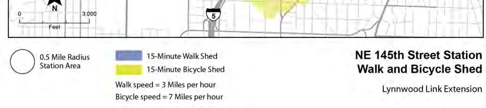
16 Figure Minute Walk Shed and 15-Minute Bicycle Shed at NE 145th Street Station 7-16 Station Area Transit-oriented Development Potential Report
17 Table Population and Employment within 15-minute Walk Shed and 15-minute Bicycle Shed at NE 145th Street Station 15-Minute Walk Shed 15-Minute Bicycle Shed 2010 Population 2010 Employment 2010 Population 2010 Employment NE 145th Street Station 5,600 1,100 37,400 11,100 Parking A parking inventory of on-street and off-street parking within 0.25 miles of the station indicates a total of 800 spaces (see Table 7-4). Fifty-six percent of the available parking is on-street, and no parking is time-restricted. An existing surface park-and-ride adjacent to the station site is 94 percent utilized; off-street parking associated with Lakeside School is 100 percent utilized. Overall, mid-day utilization is 46 percent of all available parking. The North Jackson Park-and-Ride is located just adjacent to the NE 145th Street Station, accessed from 5th Avenue NE and contains 68 parking spaces. Table 7-4. Parking Supply and Utilization near the NE 145th Street Station Area Parking Supply Midday Utilization No Restrictions Time-Restricted Total Vehicles % Utilization On-Street % Off-Street % Note: Data were collected in May Utilization was counted between 9 am and 11 am and between 1 pm and 4 pm. Similar to the NE 130th Street Station, the 0.25-mile radius station area encompasses singlefamily developments, a golf course, and schools and religious institutions. Current parking requirements in this area include one to two off-street parking spaces per unit. The City of Shoreline Planning Director may reduce parking requirement by up to 50 percent if parking demand can be adequately met by available parking in proximity to transit routes, commute trip reduction programs, and other measures. Bicycle parking is required for developments over a certain size. Table C-3, Attachment C, provides a summary of general parking requirements. 7.5 Potential Development Opportunities The NE 145th Street Station offers limited development opportunities. The proposed NE 145th Street Station is located north of NE 145th Street east of I-5 and directly south of an existing park-and-ride. A station at this location currently requires the acquisition of Station Area Transit-oriented Development Potential Report 7-17
18 private property to construct the facility. This may be refined as the design progresses. A parking garage of up to 500 stalls is planned for this station and this number may be refined as the design progresses. NE 145th Street is the border between Seattle and Shoreline. All property to the north of NE 145th Street is in Shoreline and all property to the south is in Seattle. The half-mile station area is dominated by established single-family neighborhoods. The largest private property owner in this station area is Lakeside School, which owns approximately 30 acres across I-5 to the southwest of the station. Lakeside School has made significant infrastructure investments in its property and it is unlikely to be redeveloped in the foreseeable future. With the exception of a small sliver of land at the edge of the station area, the publicly owned Jackson Park Golf Course covers the entire southeast quadrant. This sliver, consisting mostly of commercial and multifamily development, is concentrated around the intersection of NE 145th Street and 15th Avenue NE and represents the densest development in the station area. This area contains a few potential TOD properties with low improvement-to-total assessed value. The only other area that offers TOD potential is made up of a few moderately large parcels with relatively low improvement-to-total assessed values, located along I-5 to the north of NE 147th Street; however, this area has very little existing commercial or multifamily development. Preliminary Market Assessment The most likely market segments were assessed at a preliminary level and are represented in Table 7-5. Section provides details on how these markets were assessed. Since this is a preliminary assessment, a rating for station area market assessment was not determined and is not included in the Potential Development Opportunities rating, above. More analysis may be required for certain market segments as noted in the summary table. Table 7-5. Summary Conclusion of Preliminary Market Assessment by Market Segment for NE 145th Street Station Market Segment Office Market Retail Market Apartment Market Lodging Market Summary Conclusion No evidence exists to support speculative office development in the foreseeable future. Long-term demand will be a function of employment and development activity in competing areas. The station area is moderately well suited to attract neighborhood-oriented retail in the mid- to long-term. From a demand perspective, the station area will likely support apartment development. Further analysis is needed to determine the financial feasibility of new construction. There may be enough long-term demand to support a small limited service hotel. Further analysis is warranted Station Area Transit-oriented Development Potential Report
19 Office Vacancy in the office market area bounded by Lake Washington to the east, Puget Sound to the west, N 205th Street to the north, and N/NE 95th Street to the south is currently at 7.4 percent, with an average asking rental rate of $22 per square foot. The most significant projects built within this market over the last decade include two medical office buildings located close to the Northwest Hospital, and the 67,000 square foot Shoreline City Hall. Over this same period, there has only been one non-medical office building with over 10,000 square feet constructed by the private sector. Going forward, the market is unlikely to attract speculative development in the short- to mid-term. Long-term demand will likely be limited to a few select locations. The station area itself is solidly residential and currently contains less than 10,000 square feet of office space. Although this is partially a function of zoning, the economics of redeveloping existing residential structures to free up land for office development is not readily financially feasible under current conditions. The station area does offer a few of the amenities that office users look for such as immediate and freeway access and connectivity to office supportive retail. While it is difficult to forecast market conditions beyond five years, there is no evidence to support a significant increase in mid- to long-term demand. Should employment growth increase beyond current estimates, the station area may attract a small amount of office space long-term. Retail Most of the existing retail space within the market area bounded by Lake Washington to the east, Puget Sound to the west, N 205th Street to the north, and N/NE 95th Street to the south, is concentrated around the Northgate Mall, along Highway 99, along Lake City Way, and around major 15th Avenue NE intersections. Vacancy currently sits below 5 percent in all age buildings, with an average asking rental rate of $18 per square foot. Asking rental rates for buildings constructed over the last five years average $23 per square foot. The station area itself is moderately well suited to attract neighborhood-serving retail; particularly at major, signalized intersections along NE 145th Street. This street offers relatively high traffic volumes and is one of the major east/west connector streets from Highway 99 to Lake City Way. Developers positioning projects to attract national and regional tenants however, are more likely to favor locations that offer proximity to larger retail clusters and exposure to more prominent arterials. Apartment The North Seattle/Shoreline market is currently experiencing historically low vacancies and rising rental rates. Vacancy in all age buildings is at 4 percent and vacancy in buildings delivered over the last five years is around 3 percent. Rental rates in buildings delivered within the last five years average $1.70 per square foot. Although this market currently favors landlords, with Station Area Transit-oriented Development Potential Report 7-19
20 over 1,000 units in construction or in the planning stages, the market is at risk of becoming over-saturated, which would put downward pressure on rents. If vacant commercial land were available within the station area, from a demand perspective, apartment development would be supported, particularly on sites close to the intersection of NE 145th Street and 15th Avenue NE. This area already contains existing apartment projects, offers proximity to retail, is close to amenities such as a public golf course and park, offers a reasonably short commute to major employers such as the Northgate Mall, and offers direct access to I-5. Although demand likely exists for apartment development within the station area, more study is needed to determine if rents will support new construction. Lodging There is evidence of short-term demand for additional hotel rooms along the section of I-5 that runs from Northgate to Lynnwood. The most promising sites offer; easy access to demand generators such as malls, hospitals, universities and other large employment centers; direct north and south freeway access; freeway visibility; and proximity to compatible retail offerings. Highway oriented sites close to the Northgate Mall and Alderwood Mall (in Lynnwood) offer these amenities and are attracting developer interest as illustrated by planned hotel projects at both of these locations. Although there aren t any significant demand generators along I-5 between the two malls, local demand may support a limited amount of hotel development due to a gap in offerings. Currently, the Studio Six extended stay hotel in Mountlake Terrace is the only highway oriented hotel serving this section of I-5. The station area itself is a moderately attractive location for hotel development. On the positive side, traffic volumes on NE 145th Street are relatively high, it offers direct north and south freeway access, and it is directly connected to Highway 99 and Lake City Way via NE 145th Street. On the negative side, the station area is not located near a major demand generator, contains little commercial activity, and lacks sufficient residential density to support a hotel that depends exclusively on local demand. In conclusion, preliminary analysis suggests that there may be enough demand to support a small (80 to 100 units) limited service hotel within the station area long-term Station Area Transit-oriented Development Potential Report
BEAR CREEK PARK AND RIDE
 BEAR CREEK PARK AND RIDE 7760 178th Pl NE, Redmond, WA 98052 700 Average weekday transit boardings 283 Parking spaces Owned by King County Metro Served by Sound Transit and King County Metro Bear Creek
CONNECTING PEOPLE TO PLACES
 CONNECTING PEOPLE TO PLACES 82 EAST BENCH MASTER PLAN 07 Introduction The East Bench transportation system is a collection of slow moving, treelined residential streets and major arteries that are the
Interim Transit Ridership Forecast Results Technical Memorandum
 Interim Transit Ridership 401 South Jackson Street Seattle, WA 98104-2826 September 2012 Table of Contents 1 INTRODUCTION... 1-1 1.1 Project Background... 1-1 2 RIDERSHIP FORECASTS... 2-1 2.1 System Ridership
PRINCE GEORGE S PLAZA METRO AREA PEDESTRIAN PLAN
 PRINCE GEORGE S PLAZA METRO AREA PEDESTRIAN PLAN May 28, 2008 Agenda Welcome and introductions Project overview and issue identification Planning context and strengths Design challenges and initial recommendations
City of Wayzata Comprehensive Plan 2030 Transportation Chapter: Appendix A
 A1. Functional Classification Table A-1 illustrates the Metropolitan Council s detailed criteria established for the functional classification of roadways within the Twin Cities Metropolitan Area. Table
Agenda. Overview PRINCE GEORGE S PLAZA METRO AREA PEDESTRIAN PLAN
 PRINCE GEORGE S PLAZA METRO AREA PEDESTRIAN PLAN May 28, 2008 Agenda Welcome and introductions Project overview and issue identification Planning context and strengths Design challenges and initial recommendations
Land Use and Transportation Town Hall September 17, 2018
 Land Use and Transportation Town Hall September 17, 2018 Welcome! Tonight s Agenda: 7:00-7:30 OVERVIEW PRESENTATIONS 7:30-8:15 BREAKOUT SESSIONS 8:15 - End TOWN HALL CITIZEN S TIME Purpose of Tonight s
4. ENVIRONMENTAL IMPACT ANALYSIS 9. TRANSPORTATION AND TRAFFIC
 4. ENVIRONMENTAL IMPACT ANALYSIS 9. TRANSPORTATION AND TRAFFIC 4.9.1 INTRODUCTION The following section addresses the Proposed Project s impact on transportation and traffic based on the Traffic Study
CITY OF COCOA BEACH 2025 COMPREHENSIVE PLAN. Section VIII Mobility Element Goals, Objectives, and Policies
 CITY OF COCOA BEACH 2025 COMPREHENSIVE PLAN Section VIII Mobility Element Goals, Objectives, and Policies Adopted August 6, 2015 by Ordinance No. 1591 VIII MOBILITY ELEMENT Table of Contents Page Number
Executive Summary Route 30 Corridor Master Plan
 Route Corridor Master Plan Project Overview The Route Corridor Master Plan is a coordinated multimodal transportation and land use plan for the entire stretch of Route through East Whiteland Township,
summary of issues and opportunities
 1 summary of issues and opportunities EXECUTIVE SUMMARY CHAPTER 2: HISTORY - 3: LAND USE This first chapter is an overview of lessons learned from analysis of the existing conditions on El Camino as well
3.0 Future Conditions
 3.0 Future Conditions In order to be able to recommend appropriate improvements to the transportation system of the Town, it is important to first understand the nature and volume of traffic that is expected
INNER LOOP EAST. AIA Rochester Annual Meeting November 13, 2013 TRANSFORMATION PROJECT. Bret Garwood, NBD Erik Frisch, DES
 INNER LOOP EAST TRANSFORMATION PROJECT AIA Rochester Annual Meeting November 13, 2013 Bret Garwood, NBD Erik Frisch, DES Why? We are building a city that encourages walking, biking and enjoying the outdoor
Project Narrative. Albuquerque, NM. July 31, 2015
 Project Narrative Albuquerque, NM July 31, 2015 1 Project Identification As the first bus rapid transit (BRT) project in New Mexico, the Albuquerque Rapid Transit (ART) line will run through the heart
Chapter 5 Future Transportation
 Chapter 5 Future Transportation The Future Land Use Plan identifies the desired land use designations. The land uses desired for Crozet depend, in large part, on the success of the transportation system,
PEDESTRIAN ACTION PLAN
 ATTACHMENT 2 CITY OF SANTA MONICA PEDESTRIAN ACTION PLAN CITY OF SANTA MONICA PEDESTRIAN ACTION PLAN This page intentionally left blank EXECUTIVE SUMMARY CHAPTER 1 EXECUTIVE SUMMARY Setting the Stage
SECTION 1 - TRAFFIC PLANNING
 SECTION 1 - TRAFFIC PLANNING 1.1 TRAFFIC OPERATIONS 1.1.1 Roadway Functional Classification The Multnomah County Comprehensive Framework Plan s Policy 34: Trafficways and the Functional Classification
2010 Pedestrian and Bicyclist Special Districts Study Update
 2010 Pedestrian and Bicyclist Special Districts Study Update Pedestrian and Bicyclist Special Districts Program Overview H-GAC s Special Districts Program aims to provide strategic investments in pedestrian
ATTACHMENT 4 - TDM Checklist. TDM Checklist Overview
 ATTACHMENT 4 - TDM Checklist TDM Checklist Overview The proposed checklist rates developments on the degree to which they are TDM and transit supportive. Points are assigned based on the level of transit
Bicycle and Pedestrian Advisory Committee (BPAC) November 21, 2013
 November 21, 2013") Bicycle and Pedestrian Advisory Committee (BPAC) November 21, 2013 OVERALL LAND USE CONCEPT Overall Broadway Valdez District: 95.5 acres (35.1 acres right-of ways + 60.4 acres developable land) Plan Subareas:
Bicycle and Pedestrian Advisory Committee (BPAC) November 21, 2013 OVERALL LAND USE CONCEPT Overall Broadway Valdez District: 95.5 acres (35.1 acres right-of ways + 60.4 acres developable land) Plan Subareas:
Clackamas County Comprehensive Plan
 ROADWAYS The County s road system permits the movement of goods and people between communities and regions, using any of a variety of modes of travel. Roads provide access to virtually all property. They
HENDERSON DEVELOPMENT 213, 217, 221, 221 ½, 223 HENDERSON AVENUE and 65 TEMPLETON STREET OTTAWA, ONTARIO TRANSPORTATION OVERVIEW.
 HENDERSON DEVELOPMENT 213, 217, 221, 221 ½, 223 HENDERSON AVENUE and 65 TEMPLETON STREET OTTAWA, ONTARIO TRANSPORTATION OVERVIEW Prepared for: 2294170 Ontario Inc. February 2, 2017 117-652 Report_1.doc
Transportation Impact Study for Abington Terrace
 Transportation Impact Study for Abington Terrace Abington Township, Montgomery County, PA Sandy A. Koza, P.E., PTOE PA PE License Number PE059911 Prepared by McMahon Associates, Inc. 425 Commerce Drive,
ADOT Statewide Bicycle and Pedestrian Program Summary of Phase IV Activities APPENDIX B PEDESTRIAN DEMAND INDEX
 ADOT Statewide Bicycle and Pedestrian Program Summary of Activities APPENDIX B PEDESTRIAN DEMAND INDEX May 24, 2009 Pedestrian Demand Index for State Highway Facilities Revised: May 29, 2007 Introduction
Chapter 7. Transportation. Transportation Road Network Plan Transit Cyclists Pedestrians Multi-Use and Equestrian Trails
 Chapter 7 Transportation Transportation Road Network Plan Transit Cyclists Pedestrians Multi-Use and Equestrian Trails 7.1 TRANSPORTATION BACKGROUND The District of Maple Ridge faces a number of unique
SETTINGS AND OPPORTUNITIES MOBILITY & ACCESS
 7 mobility & access how do people use el camino what is it like to drive on el camino/to park along el camino what is the pedestrian experience like what is the role of transit along the corridor what
Anniedale- Tynehead NCP Best Practices in Transportation Planning Summary
 Anniedale- Tynehead NCP Best Practices in Transportation Planning Summary The City of Surrey Anniedale-Tynehead NCP Best Practices Transportation Summary This document provides a summary of the Bunt &
Capital and Strategic Planning Committee. Item III - B. April 12, WMATA s Transit-Oriented Development Objectives
 Capital and Strategic Planning Committee Item III - B April 12, 2018 WMATA s Transit-Oriented Development Objectives Page 24 of 76 Washington Metropolitan Area Transit Authority Board Action/Information
This page intentionally left blank.
 This page intentionally left blank. COMMUNITY Glenpool Community Overview Glenpool Glenpool is a city of nearly 12,000 residents located in Tulsa County southwest of Tulsa and Jenks. The city is growing
Prepared For: Shieldbay Developments Inc. c/o Matson, McConnell Ltd. 2430A Bloor Street West Toronto, Ontario M6S 1P9.
 Prepared For: Shieldbay Developments Inc. c/o Matson, McConnell Ltd. 2430A Bloor Street West Toronto, Ontario M6S 1P9 Prepared By: URS Canada Inc. 4 th Floor, 30 Leek Crescent Richmond Hill, Ontario L4B
Solana Beach Comprehensive Active Transportation Strategy (CATS)
") Solana Beach Comprehensive Active Transportation Strategy (CATS) 3.0 Goals & Policies The Solana Beach CATS goals and objectives outlined below were largely drawn from the Solana Beach Circulation Element
Solana Beach Comprehensive Active Transportation Strategy (CATS) 3.0 Goals & Policies The Solana Beach CATS goals and objectives outlined below were largely drawn from the Solana Beach Circulation Element
RZC Appendix 8A Marymoor Subarea Street Requirements
 RZC Appendix 8A Marymoor Subarea Street Requirements For additional design details for Marymoor Subarea infrastructure, refer to the 2017 Marymoor Subarea Infrastructure Planning Report. STREET REQUIREMENTS
Garden City State Street Corridor Existing Conditions October 2012
 Garden City State Street Corridor Existing Conditions October 2012 Prepared by Garden City Development Services Leon Letson, Missy Harris & Jenah Thornborrow 6015 Glenwood Street Garden City, Idaho 83714
12/13/2018 VIA
 12/13/2018 VIA EMAIL Daniel Abbes, Assistant Planner City of Sacramento community Development Department 300 Richards Blvd., 3 rd Floor Sacramento, CA 95811 RE: Bruceville Apartments (P18-073) Dear Mr.
Employment 8,881 17,975 9,094. Households 18,990 31,936 12,946
 This section describes the future transportation environment of the UW Tacoma campus and surrounding area. A description of the future conditions on campus in terms of the street system, traffic and intersection
Overview. Existing Conditions. Corridor Description. Assessment
 Overview A study of the 23 rd Street corridor was undertaken to document the existing conditions, analyze traffic operations, and recommend remedies for deficient situations Although 23 rd Street is frequently
Sixth Line Development - Transit Facilities Plan
 Memorandum Date: November 13, 2012 To: From: c.c. Subject: Rob Freeman (Freeman Planning) Kevin Phillips Sixth Line Development - Transit Facilities Plan 33016631 This memo was prepared to review the transit
In station areas, new pedestrian links can increase network connectivity and provide direct access to stations.
 The Last Mile Planning for Pedestrians Planning around stations will put pedestrians first. Making walking to stations safe and easy is important; walking will be a part of every rapid transit Accessible
NORTH SEATTLE SUBJECT PROPERTY DEVELOPMENT SITE. Dane Erickson TH AVE NE SEATTLE, WA 98125
 NORTH SEATTLE DEVELOPMENT SITE 11514 15 TH AVE NE SEATTLE, WA 98125 Dane Erickson 206.769.2013 Dane@urbanseattle.com Property Description Offering Urban Commercial Partners is pleased to offer the property
Feasibility Study. Expo-Downtown Bicycle Connector
 Feasibility Study Expo-Downtown Bicycle Connector May 2017 Table of Contents Introduction... 2 Project Goals... 2 Study Scope... 2 Community Engagement... 3 Project Description... 6 Considerations... 6
ANGLE LAKE DISTRICT STATION AREA PLAN
 SCHOOL ANGLE LAKE DISTRICT STATION AREA PLAN ADOPTED JULY 2015 TABLE OF CONTENTS Introduction... 1 Existing Conditions... 4 Economic Opportunity... 15 Community Vision... 18 Urban Design Framework... 22
South King County High-Capacity Transit Corridor Study
 HIGH-CAPACITY TRANSIT CORRIDOR STUDY South King County Corridor South King County High-Capacity Transit Corridor Study Corridor Report August 2014 South King County High Capacity Transit Corridor Report
APPENDIX G: INTERSECTION NEEDS AT OKEECHOBEE BOULEVARD
 APPENDIX G: INTERSECTION NEEDS AT OKEECHOBEE BOULEVARD INTERSECTION NEEDS AT SR 7 and OKEECHOBEE BOULEVARD SR 7 Extension Project Development and Environment (PD&E) Study From Okeechobee Boulevard (SR
City of Novi Non-Motorized Master Plan 2011 Executive Summary
 City of Novi Non-Motorized Master Plan 2011 Executive Summary Prepared by: February 28, 2011 Why Plan? Encouraging healthy, active lifestyles through pathway and sidewalk connectivity has been a focus
Land Use and Urban Design
 35th ST 36th ST 37th ST 39th ST 40th ST 41st ST 34th ST 35th ST 36th ST 37th ST 38th ST 39th ST 40th ST Land Use and Urban Design Map 3: Corridors Land uses have evolved over many decades to accommodate
Omaha s Complete Streets Policy
 Omaha s Complete Streets Policy (Adopted August 2015) VISION To create great places and enhance our quality of life, the City of Omaha will provide safe, accessible streets for all users. Complete Streets
Illustrated Principles of Good Planning
 Illustrated Principles of Good Planning The Miami 21 Zoning Code incorporates time-tested planning principles into the zoning regulations of our City. These are principles that make for better neighborhoods,
Plant City Walk-Bike Plan
 Plant City Walk-Bike Plan Plant City Commute Mode Share 2.2% 1.4% 2.9% Drove alone 10.2% Carpooled Public transportation (0.1%) Walked Used a Bike (0.4%) 82.9% Taxicab, motorcycle, or other means Worked
Report. Typical Sections. City of Middleton, WI
 Report Typical Sections City of Middleton, WI December 2006 Report for City of Middleton, Wisconsin Typical Sections repared by: Traffic Associates LLC and STRAND ASSOCIATES, INC. 910 West Wingra Drive
INTERMODAL TRANSPORTATION PLAN
 INTRODUCTION INTERMODAL TRANSPORTATION PLAN Effective intermodal transportation implies a public policy for actively decreasing the demand for automobile trips and consequently reducing automobile related
Traffic Impact Memorandum. May 22, 2018
 BISHOP PROFESSIONAL DEVELOPMENT BUILDING Proposed Land-use Change & Parking Modification 3601 SW 31st Street Topeka, Kansas 66614 CFS Project No. 185077 Traffic Impact Memorandum May 22, 2018 Prepared
REGIONAL BICYCLE AND PEDESTRIAN DESIGN GUIDELINES
 REGIONAL BICYCLE AND PEDESTRIAN DESIGN GUIDELINES November 16, 2011 Deb Humphreys North Central Texas Council of Governments Bicycle and Pedestrian Advisory Committee Snapshot of the Guide 1. Introduction
CENTENNIAL NEIGHBOURHOODS SECONDARY PLAN STUDY CITY OF HAMILTON SPECIFIC MAP COMMENTS FROM DECEMBER 1st PUBLIC INFORMATION CENTRE #2
 OPTION #2 - MIXED USE MEDIUM DENSITY OPTION #3 - MIXED USE MEDIUM AND HIGH DENSITY Look at other uses besides industrial along Barton Street over the long term. Residential facing waterfront over long
City of Homewood Transportation Plan
 City of Homewood Transportation Plan Prepared for: City of Homewood, Alabama Prepared by: Skipper Consulting, Inc. May 2007 TABLE OF CONTENTS INTRODUCTION... 1 BACKGROUND INFORMATION... 1 EXISTING TRANSPORTATION
Comments EXECUTIVE SUMMARY
 Comments 1. Under any Alternatives, MCDOT should provide better at-grade pedestrian crossing of Georgia Avenue and Forest Glen Road, including improved crosswalks with wider medians and adequate signal
complete streets design and construction standards public primer City of Edmonton
 complete streets design and construction standards public primer City of Edmonton introduction Complete Streets are streets for everyone: people who walk, wheel, bike, take transit, or drive. They are
Public Meeting #1 January 30, 2018
 Public Meeting #1 January 30, 2018 Meeting Outline Mayor s Introduction Presentation Q&A Group Activities Wrap-up Presentation Outline Introduction Existing Conditions Market Assessment Break-out Setup
TRAFFIC ACTION PLAN. North Central Neighborhood CITY OF SAN MATEO
 TRAFFIC ACTION PLAN North Central Neighborhood CITY OF SAN MATEO Draft February 2017 Table of Contents Introduction... 1 The Traffic Forum Process... 4 Neighborhood Traffic Issues... 6 Neighborhood Recommendations
Vision: Traditional hamlet with an attractive business/pedestrian friendly main street connected to adjacent walkable neighborhoods
 N D. Focus Area II Vision: Traditional hamlet with an attractive business/pedestrian friendly main street connected to adjacent walkable neighborhoods Transit Road Focus Area II is located in the Hamlet
Figure 4-10: Pedestrian Improvements Types of Potential Station Area Improvements - Place-Making Improvements
 INCORPORATE FEATURE PAVIN IN CROSSWALK AND INTERSECTION FIELDS Identifies high-priority pedestrian areas and create a station identity through colorful and interesting patterns ADD CURB EXTENSIONS Extending
ACTIVE TRANSPORTATION
 ACTIVE TRANSPORTATION Mobility 2040 Supported Goals Improve the availability of transportation options for people and goods. Support travel efficiency measures and system enhancements targeted at congestion
CHAPTER 4: IDENTIFICATION OF ROAD SYSTEM DEFICIENCIES: TRANSPORTATION PLANNING MODEL
 CHAPTER 4: IDENTIFICATION OF ROAD SYSTEM DEFICIENCIES: TRANSPORTATION PLANNING MODEL I. INTRODUCTION Transportation planning models are the primary tools used to predict future travel conditions. With
See Figure 38, Existing Nonmotorized Connections.
 Nonmotorized Connections Existing Nonmotorized Connections Pedestrian, vehicle and bike traffic access and movements are confined primarily to Penny Drive on campus. Due to the steep slope along the length
EXECUTIVE SUMMARY: TRANSIT-ORIENTED DEVELOPMENT IN SMITHS FALLS, ONTARIO; A COMPARISON BETWEEN TWO SITES
 EECUTIVE SUMMARY: TRANSIT-ORIENTED DEVELOPMENT IN SMITHS FALLS, ONTARIO; A COMPARISON BETWEEN TWO SITES Topic and Purpose In 2007, the Mayor of Ottawa s Task Force on Transportation suggested adding a
DRAFT - CITY OF MEDFORD TRANSPORTATION SYSTEM PLAN Roadway Cross-Sections
 Roadway Cross-Sections Medford s roadway cross-section standards apply to new and reconstructed roads. The crosssections take into consideration roadway function and operational characteristics, including
Exhibit 1 PLANNING COMMISSION AGENDA ITEM
 Exhibit 1 PLANNING COMMISSION AGENDA ITEM Project Name: Grand Junction Circulation Plan Grand Junction Complete Streets Policy Applicant: City of Grand Junction Representative: David Thornton Address:
5 CIRCULATION AND STREET DESIGN
 5 CIRCULATION AND STREET DESIGN This chapter describes circulation and streetscape improvements proposed for the Northwest Chico Specific Plan Area. It includes detailed design specifications for existing
Grove Hall Business District Parking Analysis
 Grove Hall Business District Parking Analysis February 2014 Prepared for The Roxbury Great Neighborhoods Partnership Nuestra Comunidad Development Corporation Dudley Square Main Streets Greater Grove Hall
6.0 PEDESTRIAN AND BICYCLE FACILITIES 6.1 INTRODUCTION 6.2 BICYCLE DEMAND AND SUITABILITY Bicycle Demand
 6.0 PEDESTRIAN AND BICYCLE FACILITIES 6.1 INTRODUCTION Bicycle and pedestrian travel along and in the vicinity of the corridor is part of the vision of Somerset and Hunterdon counties and the integrated
Traffic Assessment for Woodhaven Redevelopment. City of Rome Oneida County, New York. March 2, 2018
 March 2, 2018 Traffic Assessment for Woodhaven Redevelopment City of Rome Oneida County, New York Prepared for: City of Rome 198 N. Washington Street Rome, NY 13440 Prepared by: C.T. MALE ASSOCIATES 50
7/23/2017 VIA . Michael Hanebutt City of Sacramento Community Development Department 300 Richards Boulevard, 3 rd Floor Sacramento, CA 95811
 7/23/2017 VIA EMAIL Michael Hanebutt City of Sacramento Community Development Department 300 Richards Boulevard, 3 rd Floor Sacramento, CA 95811 RE: 65 th Street Apartments (DR17-220) Dear Mr. Hanebutt:
BETHEL ROAD AND SEDGWICK ROAD CORRIDOR STUDY
 DRAFT PLAN City Council Meeting August 14, 2017 STUDY AREA Sedgwick Corridor State Route 160, principal arterial with Class 3 access management designation, commuter and freight route, connection to SR
Goodlettsville Bicycle and Pedestrian Plan Executive Summary
 Goodlettsville Bicycle and Pedestrian Plan July 2010 In Cooperation with the Nashville Area Metropolitan Planning Executive Organization Summary Introduction Progressive and forward thinking communities
MEETING Agenda. Introductions. Project Overview. Key Study Components. Alternative Station Concepts. Preferred Station Concept. Next Steps.
 City GARLAND Council ROADVISION Briefing STUDY VISION STUDY Dallas, TX April 8, 2010 1 1 MEETING Agenda Introductions Project Overview Key Study Components Alternative Station Concepts Preferred Station
Chapter 6 Transportation Plan
 Chapter 6 Transportation Plan Transportation Plan Introduction Chapter 6 Transportation Plan Transportation Plan Introduction This chapter describes the components of Arvada s transportation system, comprised
ACTION TRANSMITTAL No
 Transportation Advisory Board of the Metropolitan Council of the Twin Cities ACTION TRANSMITTAL No. 2016-15 DATE: January 14, 2016 TO: TAC Planning Committee PREPARED BY: Steven Elmer (651) 602-1756 SUBJECT:
CITY OF ALPHARETTA DOWNTOWN MASTER PLAN TRAFFIC EVALUATION
 CITY OF ALPHARETTA DOWNTOWN MASTER PLAN TRAFFIC EVALUATION June 2015 CITY OF ALPHARETTA DOWNTOWN MASTER PLAN TRAFFIC EVALUATION Introduction The Alpharetta Downtown Master Plan was developed in the fall
CONNECTIVITY PLAN. Adopted December 5, 2017 City of Virginia Beach
 CONNECTIVITY PLAN Adopted December 5, 2017 City of Virginia Beach CONTENTS 1.0 Background & Purpose... 2 2.0 Existing Inventory & Analysis... 3 ViBe District Existing Walking Conditions... 4 3.0 ViBe District
2.0 Existing Conditions
 20 2.0 Existing Conditions 2.1 Land Use, Future Growth Patterns, Physical Barriers Geographic Overview Sutter County s land use pattern is characterized by extensive agricultural areas, significant natural
Magnolia Place. Traffic Impact Analysis. Prepared for: City of San Mateo. Prepared by: Hexagon Transportation Consultants, Inc.
 Magnolia Place Traffic Impact Analysis Prepared for: City of San Mateo Prepared by: Hexagon Transportation Consultants, Inc. Updated January 4, 2010 Table of Contents 1. Introduction...1 2. Existing Conditions...6
C C C
 C-012-001 Thank you for your support for the creation of new public space and nonmotorized access between downtown and the waterfront through the Overlook Walk, the East-West Connections, and the Promenade.
Perryville TOD and Greenway Plan
 Perryville TOD and Greenway Plan Greenway Glossary Pathway: A bicycle and pedestrian path separated from motorized vehicular traffic by an open space, barrier or curb. Multi-use paths may be within the
3105 Alderwood Mall Blvd, Lynnwood, WA FOR SALE PAUL SLEETH th Street SW. Alderwood Mall Parkway
 3105 Alderwood Mall Blvd, Lynnwood, WA 98036 196th Street SW Alderwood Mall Alderwood Mall Parkway FOR SALE PAUL SLEETH 206.518.9547 paul.sleeth@ngkf.com BILLY SLEETH 206.518.9567 billy.sleeth@ngkf.com
SANTA CLARA COUNTYWIDE BICYCLE PLAN August 2008
 SANTA CLARA COUNTYWIDE BICYCLE PLAN August 2008 To assist VTA and Member Agencies in the planning, development and programming of bicycle improvements in Santa Clara County. Vision Statement To establish,
A Selection Approach for BRT Parking Lots Nicolls Road Corridor Parking Study
 A Selection Approach for BRT Parking Lots Nicolls Road Corridor Parking Study Chirantan Kansara, P.E. Engineering Construction Design Planning 2018 ITE Northeastern District Annual Meeting Lake George,
Southwest Bus Rapid Transit (SW BRT) Functional Planning Study - Executive Summary January 19 LPT ATTACHMENT 2.
 Functional Planning Study - Executive Summary January 19 LPT ATTACHMENT 2.") Southwest Bus Rapid Transit (SW BRT) Functional Planning Study - Executive Summary 2011 January 19 1 of 19 Introduction This executive summary presents the results of the Southwest Bus Rapid Transit (SW
Southwest Bus Rapid Transit (SW BRT) Functional Planning Study - Executive Summary 2011 January 19 1 of 19 Introduction This executive summary presents the results of the Southwest Bus Rapid Transit (SW
10/30/2012 VIA
 10/30/2012 VIA EMAIL David Hung, Associate Planner Community Development Department, Current Planning Division City of Sacramento 300 Richards Blvd., 3 rd Floor Sacramento, CA 95811 RE: The Cannery On-Site
Contents. Champaign-Urbana Mass Transit District Stop Placement Guidelines
 Contents Champaign-Urbana Mass Transit District Introduction... 1 Stop Spacing... 2 Rural... 2 Low Density Suburban... 2 General Urban... 2 Urban Core... 2 Operational Safety... 3 Stop Placement... 4 Nearside
INTRODUCTION THOROUGHFARE SYSTEM CLASSIFICATIONS
 INTRODUCTION The thoroughfare plan will assist public officials in the development of a specialized system for efficient and safe movement of vehicular traffic while minimizing potential conflicts with
A Matter of Fairness: ROCOG s Environmental Justice Protocol. What is Mobility Limitation?
 No Person Left Behind What is Mobility Limitation? What is the Access Limitation? Environmental Justice population should be provided adequate mobility & access to meet their needs; Identify acceptable
COWETA HIGH SCHOOL AND EAST HIGHWAY 51
 COWETA HIGH SCHOOL AND EAST HIGHWAY 51 Lack of sidewalks along Ben Lumpkin Rd. Lack of crosswalks and ramps at intersection. Hwy 51 is wide to cross as a pedestrian. No ADA compliance or connection to
CITY OF BURIEN, WASHINGTON MEMORANDUM
 DATE: November 2, 2011 CITY OF BURIEN, WASHINGTON MEMORANDUM TO: FROM: SUBJECT: Burien Planning Commission Charles W. Chip Davis, AICP, Senior Planner Recommendation on Revised Comprehensive Plan Transportation
This document may be reprinted or extracted without permission, provided credit to the City of Pasadena Department of Transportation
 TRANSPORTATION IMPACT ANALYSIS CURRENT PRACTICE & GUIDELINES Prepared by: Transportation Complete Streets Division Department of Transportation 20150925 This document may be reprinted or extracted without
Technical Memorandum TRAFFIC IMPACT STUDY. RIDLEY ROAD CONVENIENCE STORE Southampton County, VA. Prepared for: Mr. David Williams.
 Technical Memorandum TRFFIC IMPCT STUDY RIDLEY ROD CONVENIENCE STORE Southampton County, V Prepared for: Mr. David Williams By: Charles Smith, P.E., PTOE EPR Charlottesville, V July 2014 1 TBLE OF CONTENTS
CURBSIDE ACTIVITY DESIGN
 5 CURBSIDE ACTIVITY DESIGN This chapter provides design guidance for separated bike lanes adjacent to curbside activities including parking, loading and bus stops. Typical configurations are presented
Town of Bethlehem. Planning Assessment. Bethlehem Town Board
 Town of Bethlehem US 9W Corridor Transportation Planning Assessment Presented e to: Bethlehem Town Board June 2009 Overview Study Background Route 9W Corridor Conditions and Improvements Selkirk Bypass
APPENDIX A: Complete Streets Checklist DRAFT NOVEMBER 2016
 APPENDIX A: Complete Streets Checklist DRAFT NOVEMBER 2016 Complete Streets Checklist MetroPlan Orlando s Complete Streets Checklist is an internal planning tool for staff to further implementation of
ADA Transition Plan. City of Gainesville FY19-FY28. Date: November 5, Prepared by: City Of Gainesville Department of Mobility
 ADA Transition Plan FY19-FY28 Date: November 5, 2018 Prepared by: City Of Gainesville Department of Mobility 1.0 INTRODUCTION 1.1 BACKGROUND The federal statute known as the Americans with Disabilities
Transportation Corridor Studies: Summary of Recommendations
 Transportation Corridor Studies: Summary of Recommendations Route 4 Corridor Study: Route 10 Corridor Study: Route 44 Corridor Study: Route 175 Corridor Study: Route 5/15 Corridor Study: Rentschler Field
CHAPTER 7 ACCESS MANAGEMENT. Background. Principles of Access Management. Hennepin County Transportation Systems Plan (HC-TSP)
") CHAPTER 7 ACCESS MANAGEMENT Background Principles of Access Management Hennepin County Transportation Systems Plan (HC-TSP) Chapter 7 Access Management 7.1 Background Access management has become an important
CHAPTER 7 ACCESS MANAGEMENT Background Principles of Access Management Hennepin County Transportation Systems Plan (HC-TSP) Chapter 7 Access Management 7.1 Background Access management has become an important