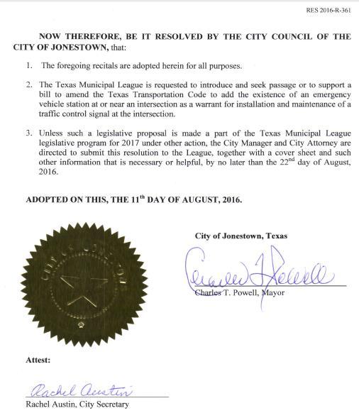
City of Jonestown Transportation Capital Improvement Plan
|
|
|
- Stephany Collins
- 5 years ago
- Views:
Transcription
1 City of Jonestown Transportation Capital Improvement Plan T h e p u r p o s e o f t h i s d o c u m e n t i s t o i d e n t i f y a n d p r i o r i t i z e t r a n s p o r t a t i o n i m p r o v e m e n t s w h i c h a r e n e e d e d f o r t h e s a f e t y a n d w e l f a r e o f t h e c i t i z e n s o f J o n e s t o w n, T e x a s P r e p a r e d b y t h e J o n e s t o w n T r a n s p o r t a t i o n C o m m i t t e e Approved by the Jonestown City Council at their meeting of August 25, 2016
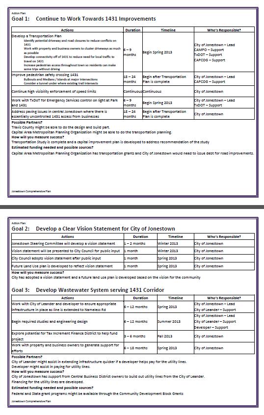
2 Members City of Jonestown, Texas Hwy 1431 Corridor Committee Brenda Sies Paul Johnson Anthony Macina James Quinn Jim Etherton With Assistance from: o Marilee Pfannstiel o Ron Wilde Mission The mission of the Committee is to identify projects on Highway 1431 within the city limits. Two categories of projects will be identified: 1. The first category includes those projects which could be funded and built within the next 0 to 5 years. These will be referred to as the Short Term projects. The limits of study for this category is: From the Georgetown Dr/Ridgeway St intersection To the Deer Canyon Road intersection 2. The second category of projects will include those projects which are considered Long Term projects which will not be funded until more than 5 years from now. The study area limits along 1431 for these projects may go beyond the study area of the Short Term projects. The Committee will consider the following factors when identifying the purpose and definition of each project: Safety (Pedestrians, cars, bikes) o Lighting o Sidewalks along 1431 o Street Cross-walks Control/directing Growth while protecting existing businesses and residences Use of roadway features to Identify and Define the City of Jonestown
3 o Features to be considered: Signs, Bridge with sign over 1431; Landscaping, Building Architecture, etc Utility issues o Water/sewer o Fire Protection o Drainage (on the roadway and off the road) Adjacent Land Use o That area outside the TxDOT Right of Way as required to accomplish the improvements to 1431 as determined to be good for the city Past Efforts More information is needed as to recent events related improvements to the traffic signals. There have been some conversations between Travis County and TxDOT regarding this topic. Efforts to Date 1. Review of Mission for Committee 2. Review of previous studies and documents 3. TxDOT Project development process 4. MPO funding Process 5. Identification of Candidate projects 6. Prioritized List of Projects Input from the City Council 1. Need turn lanes in the median of 1431 for left turn movements 2. Need signal at Park Drive Input from the Community

4 Vision of the City of Jonestown in 2033 Jonestown is a small, yet vibrant community with a thriving economy and sustainable environment. Located at the eastern edge of the Hill Country, Jonestown's greatest treasure is its breathtaking topography, with views of the hills, canyons and Lake Travis. The City has developed strategies to retain its scenic visual assets through viewshed zoning, tax incentives for development, conservation restrictions, and designating particular vistas as areas of critical concern. Like other areas where development is carefully managed rather than being allowed to occur unhindered, Jonestown's views are a drawing card with high economic value. To better manage growth as nearby land turned into suburbs, residents and stakeholders desired to be known as "The Entertainment Capital of the North Shore." The City leveraged this theme to encourage development of music venues, art and artisan shopping, restaurants, and schools with a summer-camp feel for learning music or crafts, mixed with fishing, boating, hiking, birding and other outdoor activities. The goal was to achieve growth that supports residents and attracts local visitors with the feel of a small town that is relaxed yet up-to-date. Jonestown remains predominantly residential, with working families, retirement households, seasonal visitors, and transient visitors. Various organizations and associations drive that Hill Country pioneer sense of individual responsibility where citizen volunteers willingly take on roles that are the responsibilities of local government. We treasure our rich mix of ages, occupations and income levels and work to maintain the second home, retiree and summer visitor communities attracted here by the city's outstanding natural resources and landscape. The City has adopted flexible residential zoning regulations, such as "granny" units zoning, allowing families to provide for aging parents or other relatives. The City has encouraged development that does not rely on lakeside business for survival. Commercial development occurs along the major highway route that splits the city, FM Effective long-term planning has resulted in commercial clusters along the highway, rather than one long commercial strip through the community. Transportation is designed to provide walking, biking and vehicular routes, with particular attention paid to safe pedestrian movement crossing FM Jonestown recognizes that the majority of its citizens may still travel outside of town for employment, but has encouraged the nationwide trend of home-based enterprises for arts and crafts workers, construction contractors, computer programmers, scientists and other knowledge workers, especially those whose products and services are exported beyond the


5 city. In addition to business incentives, Jonestown has established a low-rent tradesman's park where home-based businesses can relocate when they outgrow their original locations and has added multiple-use zoning to encourage multi-story development with residential spaces over retail or office. Since the Hill Country is now recognized as one of the top agricultural tourist areas, second only to California's Napa Valley, Jonestown has partnered with other communities in the region to host cultural events including theater, music, the arts, and the environment celebrating seasonal food, wine, and wildflowers. Some people lived in the area and enjoyed the relaxing outdoor environment before Lake Travis was constructed and filled in the 1950's. While the City of Jonestown was only incorporated in 1985, the community character reflects the independent pioneer spirit found throughout the Hill Country. Lacking strong historic overtones, the City of Jonestown is forward-looking, embracing change, seeking growth and development that demonstrates the best of yesterday intertwined with tomorrow. Past Reports
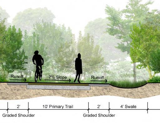
6 Short Term (2016 to 2020) List of Projects and Action Items August 17, 2016 Scope Cost Funding Source Major Constraints Initial Steps Signal on 1431 at Park Street Extend Turn Lanes to the East & West of downtown Restripe existing median downtown Mainstreet Access/turnlanes Downtown Lighting Study of potential Jonestown Bypass CAMPO Meetings to explore funding opportunities Study of opportunity to complete internal roadway loops Sidewalk and landscaping along Park Rd from 1431 to Jones Brothers Park Secondary connection of roads in Jonestown300 Coordinate with Street Committee to discuss local road needs and priorities Long Term (2021 and beyond) Modify light to provide red light for 1431 traffic when emergency vehicle needs access or when pedestrian needs to cross From G'town to Lura; Perhaps extend turn lane from E Reed Parks to Easy St. Will require p'ment widening and possible R/W acquisition. Eliminate suicide lane Add/fix light poles downtown to increase light levels for safety reasons To consider future growth and need for emergency vehicle access Understand the process and next steps that Jonestown should take Goal is to eliminate deadends Buck Run to Deer Canyon $250,000 Combination of City, State and Federal funding $5,000,000 Not Determined $250,000 Not Determined $1,000,000 Not Determined $2,000,000 Not Determined $100,000 Not Determined Current Texas Law requires that certain historical counts related to vehicular traffic, pedestrians, crashes and deaths be such to justify a fully operational signal. Currently, emergency vehicle operational needs are not an allowable consideration to justify a new signal. Funding Funding Funding Funding Funding TxDOT was contacted to find out that the current plan only involves to small pole mounted yellow flashing lights on the side of the road. No modifications to the existing flashing lights are planned. A meeting was held with CAMPO to discuss the need for the project. New State legislation is being proposed which will justify the signal. Secure Funding Secure Funding Secure Funding Secure Funding Secure Funding No Cost NA Scheduling Paul & Marilee to set up No Cost NA Scheduling $500,000 Not Determined Funding Secure Funding Possible for cost to be paid by other parties Not Determined Funding Secure Funding No Cost NA Scheduling Set Meeting Date Scope Cost Funding Source Major Constraints Initial Steps Pedestrian tunnel under 1431 Construction Not Determined Secure Funding
7 City of Jonestown, Texas Need, Purpose & Definition Of Proposed Signal on 1431 at Park Street August 8, 2016 PROJECT NAME: Signal on 1431 at Park Street Project Status: Currently a flashing yellow light is on continuous blinking for both directions of FM The intersection does not meet the Texas State Law metrics required for a fully operational signal. This intersection provides the best location for the citizens of Jonestown to cross FM 1431 in a non-motorized mode. Since FM 4131 is a high volume and high speed (50 MPH+) facility and acts as a major divide through the middle of the City, there is no safe way for pedestrians, or those in wheelchairs, or those on bikes to safely cross the highway. NEED: The proposed action is necessary to correct an existing safety hazards. Currently there are citizens who can t drive who need to walk across 1431 to reach city services such as the library, city hall, and social services. There is not one protected cross-walk on 1431 in the city. People in wheelchairs are crossing 1431 at this location with no protection. Emergency vehicles which are based on Park Street are delayed in responding to emergency calls due to the combination of no signal, high speed / high volume traffic on 1431 and the steep road approaching Families wanting to cross the street have to get in their car to make a 300 ft trip. There are high volumes of turning movements in the summer when those accessing Jones Brothers Park drive through this intersection. Many are pulling boats on trailers while making the turns. Sight distances are also a problem due to the horizontal and vertical road curves on Traffic projections indicate near term rapid increase in daily volumes on 1431 PURPOSE: Modify signal to provide protection for: Emergency vehicle access to 1431 Pedestrian ability to cross 1431 Turning vehicles when turning left on Park Street PROJECT REQUIREMENTS: Project requires approval from TxDOT since highway FM 1431 is a state facility. TxDOT indicates that they require state legislation that will add to basis for justification to allow them to approve. The City is working with TML to secure new legislation. The City of Jonestown is preparing to fund a portion of the project cost. PROJECT SCOPE: Design and construct new signal that will address NEED. It should address: Pedestrian movements New signal poles Emergency vehicle access Adjustment of existing lighting Left turn movements through intersection Pedestrian signal heads Re-striping of pavement for turn lanes, stop bars, cross-walk, etc MODAL INTERRELATIONSHIPS: The proposed action will interface with and serve CAPMETRO para-transit vehicles which use this intersection

8
9

10

11

12

13

14

15

16
17

18

19 Funding
20 Discussion with TxDOT New Traffic Signal on Hwy 1431 Jim Etherton called the Austin District of TxDOT on April 1, 2016 and spoke to David Baroi who is the TxDOT Project Manager for the new signal being considered at the intersection of Park Road and Highway 1431 in Jonestown. Mr. Baroi is in the Austin TxDOT District office lacated on I-35 just north of highway 183. His phone number is Mr. Baroi indicated that Texas law required that certain conditions be satisfied before a fully operational signal could be provided. These required conditions include consideration of: Number and type of accidents Volume of pedestrian and vehicular traffic Number of fatalities Other factors Mr. Baroi said that the intersection did not meet the minimum requirements. After consulting with others at TxDOT, it was felt that they did not have the legal basis for providing a change in the existing flashing yellow signal which is now in place. As an alternative, a concept is being developed to assist emergency vehicles when they need to gain access to highway This alternative involves the placement of two pole-mounted signs which will include yellow lights which will flash only when a button is pushed at a remote site. The button will be located in the Travis County Fire Department building which is on Park Road close to the intersection. The two pole-mounted signs will be placed on the side of Highway 1431, one will be located east of the intersection facing west-bound traffic and one will be placed west of the intersection facing east-bound traffic. The intent of these improvements is to alert motorists of the emergency vehicle s need to access Mr. Baroi said that the Fire Department will have to procure and pay for the equipment which will stay in the fire station. He indicated that it should be operational in about a year from now. Jim Etherton shared the many reasons why a more robust solution was needed by citing: The need for the actual stopping of 1431 traffic to allow fire trucks to turn left onto 1431 to travel west-bound The inability of Jonestown citizens to walk across 1431 The need to better connect the two halves of the city by providing a safer crossing location
21 The high traffic which uses this intersection to gain access to and from Jones Brothers Park during many high traffic periods during the year The lack of ability to access city and county services because of the above issues Mr Baroi stated that he understood but that his hands were tied.
22

23

24

25
PEDESTRIAN ACTION PLAN
 ATTACHMENT 2 CITY OF SANTA MONICA PEDESTRIAN ACTION PLAN CITY OF SANTA MONICA PEDESTRIAN ACTION PLAN This page intentionally left blank EXECUTIVE SUMMARY CHAPTER 1 EXECUTIVE SUMMARY Setting the Stage
Corpus Christi Metropolitan Transportation Plan Fiscal Year Introduction:
 Introduction: The Safe, Accountable, Flexible, Efficient Transportation Equity Act: A Legacy for Users (SAFETEA-LU) has continued the efforts started through the Intermodal Surface Transportation Efficiency
CITY OF BLOOMINGTON COMPLETE STREETS POLICY
 CITY OF BLOOMINGTON COMPLETE STREETS POLICY POLICY OBJECTIVE: The City of Bloomington will enhance safety, mobility, accessibility and convenience for transportation network users of all ages and abilities,
MAG Town of Cave Creek Bike Study Task 6 Executive Summary and Regional Significance Report
 Page 1 MAG Town of Cave Creek Bike Study Task 6 Executive Summary and Regional Significance Report August 1, 2012 MAG Project #481 Page 2 Task 6 Executive Summary and Regional Significance Report Introduction
Safe Routes to School Action Plan Aberdeen, Idaho
 Background Aberdeen, Idaho is a largely agricultural community of nearly 2,000 people and is located in the southeast portion of the state on the western edge of American Falls Reservoir. The community
Exhibit 1 PLANNING COMMISSION AGENDA ITEM
 Exhibit 1 PLANNING COMMISSION AGENDA ITEM Project Name: Grand Junction Circulation Plan Grand Junction Complete Streets Policy Applicant: City of Grand Junction Representative: David Thornton Address:
City of Novi Non-Motorized Master Plan 2011 Executive Summary
 City of Novi Non-Motorized Master Plan 2011 Executive Summary Prepared by: February 28, 2011 Why Plan? Encouraging healthy, active lifestyles through pathway and sidewalk connectivity has been a focus
Agenda. Overview PRINCE GEORGE S PLAZA METRO AREA PEDESTRIAN PLAN
 PRINCE GEORGE S PLAZA METRO AREA PEDESTRIAN PLAN May 28, 2008 Agenda Welcome and introductions Project overview and issue identification Planning context and strengths Design challenges and initial recommendations
HOOPA DESIGN FAIR 4. IMPLEMENTATION PHASES & FUNDING
 4. IMPLEMENTATION PHASES & FUNDING HOOPA DESIGN FAIR 4-1 4. IMPLEMENTATION PHASES & FUNDING Phase One Development 1. Implementation The Conceptual Plan recommends five concept elements to revitalize downtown
Vision: Traditional hamlet with an attractive business/pedestrian friendly main street connected to adjacent walkable neighborhoods
 N D. Focus Area II Vision: Traditional hamlet with an attractive business/pedestrian friendly main street connected to adjacent walkable neighborhoods Transit Road Focus Area II is located in the Hamlet
AMATS Complete Streets Policy
 AMATS Complete Streets Policy Table of Contents: Section 1. Definition of Complete Streets Section 2. Principles of Complete Streets Section 3. Complete Streets Policy Section 4. Consistency Section 5.
Goal 3: Foster an environment of partnerships and collaboration to connect our communities and regions to one another.
 Non-Motorized Transportation Plan (NMTP) Draft Vision, Goal and,, Tri-County Regional Planning Commission (TCRPC) Purpose The purpose of the Tri-County Regional Planning Commission (TCRPC) Non-Motorized
REGIONAL BICYCLE AND PEDESTRIAN DESIGN GUIDELINES
 REGIONAL BICYCLE AND PEDESTRIAN DESIGN GUIDELINES November 16, 2011 Deb Humphreys North Central Texas Council of Governments Bicycle and Pedestrian Advisory Committee Snapshot of the Guide 1. Introduction
BETHEL ROAD AND SEDGWICK ROAD CORRIDOR STUDY
 DRAFT PLAN City Council Meeting August 14, 2017 STUDY AREA Sedgwick Corridor State Route 160, principal arterial with Class 3 access management designation, commuter and freight route, connection to SR
NM-POLICY 1: Improve service levels, participation, and options for non-motorized transportation modes throughout the County.
 Transportation PRINCE WILLIAM COUNTY 2008 COMPREHENSIVE PLAN NON-MOTORIZED PLAN CONTENTS Goals, Policies, and Action Strategies Table 4 (Bike Facility Classifications and Descriptions) Table 5 (Bike Facility
Perryville TOD and Greenway Plan
 Perryville TOD and Greenway Plan Greenway Glossary Pathway: A bicycle and pedestrian path separated from motorized vehicular traffic by an open space, barrier or curb. Multi-use paths may be within the
AIRPORT ROAD ENVIRONMENTAL ASSESSMENT
 WELCOME TO PUBLIC INFORMATION CENTRE #1 AIRPORT ROAD ENVIRONMENTAL ASSESSMENT From Braydon Boulevard/Stonecrest Drive to Countryside Drive November 23, 2017 6:30 PM 8:30 PM Please sign in and fill out
Comments The Plan for Port Whitby
 Comments The Plan for Port Whitby April 24th, 2013 Community Meeting #2 Summary Report Prepared by GLPi April 29th, 2013 1 Introduction The purpose of the Port Whitby Secondary Plan Update, Community Improvement
Chapter 5 Future Transportation
 Chapter 5 Future Transportation The Future Land Use Plan identifies the desired land use designations. The land uses desired for Crozet depend, in large part, on the success of the transportation system,
Broad Street Bicycle Boulevard Design Guidelines
 Broad Street Bicycle Boulevard Design Guidelines Building from the strategies introduced in the 2013 Bicycle Transportation Plan and community input received thus far, City Transportation Staff have identified
Roadway Classification Design Standards and Policies. Pueblo, Colorado November, 2004
 Roadway Classification Design Standards and Policies Pueblo, Colorado November, 2004 Table of Contents Page Chapter 1. General Provisions 1.1 Jurisdiction 3 1.2 Purpose and Intent 3 1.3 Modification 3
Complete Streets. Designing Streets for Everyone. Sarnia
 Complete Streets Designing Streets for Everyone Sarnia Complete Streets ~ Sarnia ~ 2018 Introduction Our City is made up of a network of streets that we use to go for a walk, cycle to work, drive to the
East Burke Transportation, Safety and Capacity Improvements
 East Burke Transportation, Safety and Capacity Improvements The purpose of this project is to increase mobility and improve safety for pedestrians, cyclists, and motor vehicles along VT Route 114 in the
2015 Florida Main Street Annual Conference. Complete Streets Equal Stronger Main Streets
 WHAT ARE COMPLETE STREETS? CASE STUDIES COMPLETING YOUR MAIN STREET 2015 Florida Main Street Annual Conference St. Petersburg, Florida August 19, 2015 WHAT ARE COMPLETE STREETS? CASE STUDIES COMPLETING
AGENDA REPORT. Issue: Discussion of potential improvements on Barnwell Road at Niblick Drive
 AGENDA REPORT To: From: By: Honorable Mayor and City Council Members Warren Hutmacher, City Manager Tom Black, Public Works Director Date: March 23, 2016 Agenda: March 28, 2016 WORK SESSION AGENDA: Barnwell
Executive Summary Route 30 Corridor Master Plan
 Route Corridor Master Plan Project Overview The Route Corridor Master Plan is a coordinated multimodal transportation and land use plan for the entire stretch of Route through East Whiteland Township,
Capital Metro Downtown Multimodal Station
 Capital Metro Downtown Multimodal Station Open House December 11, 2015 Project Goals & Objectives 1 2 3 4 Address near- and long- term MetroRail operational needs Address existing safety issues and modal
Bay to Bay Boulevard Complete Streets Project
 Bay to Bay Boulevard Complete Streets Project Dale Mabry Highway to Bayshore Boulevard February 08, 2018 Photo Source: Tampa Bay Times Alessandra Da Pra Meeting Format Introduction Resurfacing Information
FONTAINE AVENUE STUDY Final Report
 FONTAINE AVENUE STUDY Final Report March 28, 2005 FONTAINE AVENUE STUDY City of Charlottesville March 28, 2005 Renaissance Planning Group Kenneth Schwartz, FAIA, AICP Director of Design Leigh Wilkerson,
FINAL PLAN APPENDIX D CITY OF BERKELEY BIKE PLAN D-1
 CITY OF BERKELEY BIKE PLAN D-1 . Proposed Programs D.1. EDUCATION This appendix presents the recommended bicycle-related programs for the City of Berkeley. The recommendations are organized in four E s:
Omaha s Complete Streets Policy
 Omaha s Complete Streets Policy (Adopted August 2015) VISION To create great places and enhance our quality of life, the City of Omaha will provide safe, accessible streets for all users. Complete Streets
Performance Criteria for 2035 Long Range Transportation Plan
 Minimizing Impacts on Natural, Historic, Cultural or Archeological Resources 2035 LRTP Weighting Factor: 7% Objective 1.1: Use appropriate planning and design criteria to protect and enhance the built
Chapter 5. Complete Streets and Walkable Communities.
 Chapter 5. Complete Streets and Walkable Communities. 5.1 Description of Complete Streets. Cities throughout the world, and specifically the United States, are coming to embrace a new transportation and
SAN FRANCISCO MUNICIPAL TRANSPORTATION AGENCY
 THIS PRINT COVERS CALENDAR ITEM NO. : 12 DIVISION: Sustainable Streets BRIEF DESCRIPTION: SAN FRANCISCO MUNICIPAL TRANSPORTATION AGENCY Approving various bicycle improvements and traffic modifications
CITY OF COCOA BEACH 2025 COMPREHENSIVE PLAN. Section VIII Mobility Element Goals, Objectives, and Policies
 CITY OF COCOA BEACH 2025 COMPREHENSIVE PLAN Section VIII Mobility Element Goals, Objectives, and Policies Adopted August 6, 2015 by Ordinance No. 1591 VIII MOBILITY ELEMENT Table of Contents Page Number
WELCOME!! WAIMEA REGIONAL SAFETY STUDY COMMUNITY MEETING PEL 2 DECEMBER 5, 2018 WAIMEA ELEMENTARY SCHOOL
 WELCOME!! WAIMEA REGIONAL SAFETY STUDY COMMUNITY MEETING PEL 2 DECEMBER 5, 2018 WAIMEA ELEMENTARY SCHOOL TONIGHT S AGENDA Welcome and Introductions Recap PEL 1 Meeting: What is this study? What are the
HARRISON STREET/OAKLAND AVENUE COMMUNITY TRANSPORTATION PLAN
 HARRISON STREET/OAKLAND AVENUE Community Workshop #4: Draft Plan Review December 3, 2009 D E S I G N, C O M M U N I T Y & E N V I R O N M E N T INTRODUCTIONS Key Project Staff: Alisa Shen, Project Manager,
Mainstreet Master Plan Land Use
 Mainstreet Master Plan 04 Land Use Top Recommendations Active Uses: Promote active ground-floor uses such as retail, restaurants, galleries and personal services with interactive storefronts for Mainstreet
Environment and Public Works Committee Presentation
 Mixed Use Centers Complete Streets Guidelines Project Environment and Public Works Committee Presentation December 10, 2008 Project Objectives: Conduct an inter-departmental and agency process to study
How To Encourage More Efficient Transportation in Brazilian Cities
 How To Encourage More Efficient Transportation in Brazilian Cities Todd Litman Victoria Transport Policy Institute Presented Seminar on Discouraging The Use Of Cars São Paulo, Brazil 3 September 2013 Creating
Transportation Master Plan Advisory Task Force
 Transportation Master Plan Advisory Task Force Network Alternatives & Phasing Strategy February 2016 BACKGROUND Table of Contents BACKGROUND Purpose & Introduction 2 Linking the TMP to Key Council Approved
5. Pedestrian System. Accomplishments Over the Past Five Years
 5. Pedestrian System Accomplishments Over the Past Five Years The Alamo Area Metropolitan Planning Organization (MPO) and its partner agencies recognize the importance of improving pedestrian mobility.
4. ENVIRONMENTAL IMPACT ANALYSIS 9. TRANSPORTATION AND TRAFFIC
 4. ENVIRONMENTAL IMPACT ANALYSIS 9. TRANSPORTATION AND TRAFFIC 4.9.1 INTRODUCTION The following section addresses the Proposed Project s impact on transportation and traffic based on the Traffic Study
WELCOME. Purpose of the Open House. Update you on the project. Present a draft recommended plan. Receive your input
 WELCOME Purpose of the Open House The Town of Smiths Falls has initiated the Beckwith Street Redevelopment Plan that includes the preparation of a streetscape functional design for the renewal of Beckwith
Road Diets. Presented by: Cristine Gowland, P.E. LADOTD District 62 March 2, 2016
 Road Diets Presented by: Cristine Gowland, P.E. LADOTD District 62 March 2, 2016 FHWA s 9 Proven Safety Countermeasures 1. Safety Edge 2. Roundabouts 3. Corridor Access Management 4. Backplates with Retroreflective
WELCOME TO OPEN HOUSE # 1 June 14, 2017
 Langstaff Road Weston Road to Highway 7 Class Environmental Assessment Study WELCOME TO OPEN HOUSE # 1 June 14, 2017 Please sign in and join our mailing list Purpose of Open House #1 & Study Area York
EXECUTIVE SUMMARY. Vision
 Vision Walking and bicycling in Salt Lake City will be safe, convenient, comfortable, and viable transportation options that connect people to places, foster recreational and economic development opportunities,
Bicycle Master Plan Goals, Strategies, and Policies
 Bicycle Master Plan Goals, Strategies, and Policies Mobilizing 5 This chapter outlines the overarching goals, action statements, and action items Long Beach will take in order to achieve its vision of
General Plan Circulation Element Update Scoping Meeting April 16, 2014 Santa Ana Senior Center, 424 W. 3rd Street, Santa Ana, CA 92701
 General Plan Circulation Element Update Scoping Meeting April 16, 2014 Santa Ana Senior Center, 424 W. 3rd Street, Santa Ana, CA 92701 Meeting Agenda 1. Purpose of Scoping Meeting 2. Project Overview 3.
MINERAL AVENUE CORRIDOR ASSESSMENT STUDY IMPLEMENTATION STRATEGY
 MINERAL AVENUE CORRIDOR ASSESSMENT STUDY IMPLEMENTATION STRATEGY INTRODUCTION City Personnel Sign-in Sheet Comment Forms Please Write Down Any Feedback INTRODUCTION List of Topics for Presentation Study
TRANSPORTATION & MOBILITY
 TRANSPORTATION & MOBILITY ROADWAY SYSTEM There are approximately 40 miles of roadways in Manitou Springs. For planning purposes, roadways are typically assigned a functional classification which defines
DRAFT BUENA VISTA 2020 TRANSPORTATION PLAN
 DRAFT BUENA VISTA 2020 TRANSPORTATION PLAN DEVELOPED BY THE TRANSPORTATION PLANNING DIVISION OF THE VIRGINIA DEPARTMENT OF TRANSPORTATION IN COOPERATION WITH THE U.S. DEPARTMENT OF TRANSPORTATION, FEDERAL
IMPLEMENTATION STRATEGIES
 GEORGETOWN SIDEWALK MASTER PLAN 34% of funding is dedicated to Downtown Overlay District sidewalks 28% of funding is recommended within 1/4 mile of Southwestern University 26% of funding is recommended
Chapter 2: Standards for Access, Non-Motorized, and Transit
 Standards for Access, Non-Motorized, and Transit Chapter 2: Standards for Access, Non-Motorized, and Transit The Washtenaw County Access Management Plan was developed based on the analysis of existing
Dr. M.L. King, Jr. Street North Complete Streets Resurfacing Opportunities HOUSING, LAND USE, AND TRANSPORTATION COMMITTEE MARCH 22, 2018
 Dr. M.L. King, Jr. Street North Complete Streets Resurfacing Opportunities HOUSING, LAND USE, AND TRANSPORTATION COMMITTEE MARCH 22, 2018 What s Happening The City plans to mill and resurface Dr. M.L.
City of Vestavia Hills Traffic Calming Policy for Residential Streets
 City of Vestavia Hills Traffic Calming Policy for Residential Streets PURPOSE: The purpose of the Traffic Calming Policy for Residential Streets is to address safety concerns related to vehicular traffic
CONNECTING PEOPLE TO PLACES
 CONNECTING PEOPLE TO PLACES 82 EAST BENCH MASTER PLAN 07 Introduction The East Bench transportation system is a collection of slow moving, treelined residential streets and major arteries that are the
Complete Streets Workshop Follow-up. April 27, 2011 Rockledge City Hall
 Complete Streets Workshop Follow-up April 27, 2011 Rockledge City Hall Agenda Complete Streets draft briefing presentation and sample policy language Share your Complete Streets projects and post workshop
Complete Streets: Policy Framework Complete Streets: Implementation Plans A more Complete Street: Laurier Bike Lane Pilot Project
 Complete Streets Initiatives City of Ottawa Complete Streets: Policy Framework Complete Streets: Implementation Plans A more Complete Street: Laurier Bike Lane Pilot Project Zlatko.Krstulic@Ottawa.ca May
Solana Beach Comprehensive Active Transportation Strategy (CATS)
") Solana Beach Comprehensive Active Transportation Strategy (CATS) 3.0 Goals & Policies The Solana Beach CATS goals and objectives outlined below were largely drawn from the Solana Beach Circulation Element
Solana Beach Comprehensive Active Transportation Strategy (CATS) 3.0 Goals & Policies The Solana Beach CATS goals and objectives outlined below were largely drawn from the Solana Beach Circulation Element
RiNo Railroad Crossing Connectivity Analysis. Stakeholder Workshop June 29, 2017
 RiNo Railroad Crossing Connectivity Analysis Stakeholder Workshop June 29, 2017 Ideas and Considerations Presented at Stakeholder Workshop Primary Focus: 38 th Street (between Walnut & Wynkoop) 1 Basic
Pennsylvania Avenue (CR 484) Design Alternatives Study
 Design Alternatives Study") MEMORANDUM Pennsylvania Avenue (CR 484) Design Alternatives Study Prepared for: APRIL 2016 Prepared By TABLE OF CONTENTS Project Background... 2 Previous Concept... 2 Existing Conditions... 4 New Alternatives...
MEMORANDUM Pennsylvania Avenue (CR 484) Design Alternatives Study Prepared for: APRIL 2016 Prepared By TABLE OF CONTENTS Project Background... 2 Previous Concept... 2 Existing Conditions... 4 New Alternatives...
Making Great Urban Streets Confessions of a Highway Engineer. Timothy R. Neuman.. P.E. Chief Highway Engineer CH2M HILL
 Making Great Urban Streets Confessions of a Highway Engineer Timothy R. Neuman.. P.E. Chief Highway Engineer CH2M HILL Isn t this a Great Street? Characteristics of a Great Street It is a transportation
Living Streets Policy
 Living Streets Policy Introduction Living streets balance the needs of motorists, bicyclists, pedestrians and transit riders in ways that promote safety and convenience, enhance community identity, create
Lee s Summit Road Improvement Study Public Open House June 7, 2007 Summary of Comment Card Responses
 Lee s Summit Road Improvement Study Public Open House June 7, 2007 Summary of Comment Card Responses Introduction At the Lee s Summit Road Improvement Study Public Open House held Thursday, June 7, 2007
NJDOT Complete Streets Checklist
 Background The New Jersey Department of Transportation s Complete Streets Policy promotes a comprehensive, integrated, connected multi-modal network by providing connections to bicycling and walking trip
TOWN OF MORAGA MORAGA WAY AND CAMINO PABLO/CANYON ROAD IMPROVEMENTS Town Council Meeting March 13, 2019
 TOWN OF MORAGA MORAGA WAY AND CAMINO PABLO/CANYON ROAD IMPROVEMENTS Town Council Meeting March 13, 2019 1 Edric Kwan, Public Works Director Josh Peterman, Principal, Fehr and Peers Shawn Knapp, Senior
Municipal Class EA To Address Traffic Congestion On The Ontario Street Corridor (Grand Bend) Public Information Meeting June 4, 2018
 Public Information Meeting June 4, 2018") Municipal Class EA To Address Traffic Congestion On The Ontario Street Corridor (Grand Bend) Public Information Meeting June 4, 2018 Background Agenda Traffic Study Update Class EA Alternatives Bridge
Municipal Class EA To Address Traffic Congestion On The Ontario Street Corridor (Grand Bend) Public Information Meeting June 4, 2018 Background Agenda Traffic Study Update Class EA Alternatives Bridge
North Shore Transportation Improvement Strategy
 North Shore Transportation Improvement Strategy Preliminary, Near-term Recommendation 2016 April Transportation Improvement Strategy (TIS) Comprehensive and Analytical A multi-modal transportation strategy
Item to be Addressed Checklist Consideration YES NO N/A Required Description Complete Streets Guidelines
 Passaic County Complete Streets Checklist - Concept Development Project Name Item to be Addressed Checklist Consideration YES NO N/A Required Description Complete Streets Guidelines Existing Plans Have
City of Ann Arbor Pedestrian Safety & Access Task Force
 City of Ann Arbor Pedestrian Safety & Access Task Force (PSATF) Community Wide Meeting Wednesday, July 8th 6:30 to 8:30 PM Multi purpose Room, Downtown Library www.a2gov.org/pedsafety The Greenway Collaborative,
AGENDA ITEM NO. 5b HCAOG TAC meeting of May 8, 2014
 Humboldt County Association of Governments Eureka, CA, 95501 AGENDA ITEM NO. 5b HCAOG TAC meeting of May 8, 2014 DATE: May 1, 2014 TO: HCAOG Technical Advisory Committee (TAC) FROM:, SUBJECT: Letters of
1.0 EXECUTIVE SUMMARY
 1.0 EXECUTIVE SUMMARY The Active Transportation Plan is a guide to accomplish the Town s vision for developing a network of sidewalks, on-road bicycle facilities, and trails that allow for safe and convenient
Everyone is a Pedestrian
 Everyone is a Pedestrian Improving Pedestrian Safety in Texas Transportation and Trinity River Project Committee 26 May 2015 Everyone is a Pedestrian Federal Highway Administration [ FHWA ] Programs to
ALLEY 24 TRAFFIC STUDY
 ALLEY 24 TRAFFIC STUDY in City of Frostburg, Maryland January 2013 3566 Teays Valley Road Hurricane, WV Office: (304) 397-5508 www.denniscorporation.com Alley 24 Traffic Study January 2013 Frostburg, Maryland
Appendix C. TRAFFIC CALMING PROGRAM TOOLBOX
 Appendix C. TRAFFIC CALMING PROGRAM TOOLBOX PHASE I...2 Do Not Enter Sign...3 One-Way Sign...4 Turn Prohibition...5 Pavement Markings...6 Speed Monitoring Trailer...7 Neighborhood Speed Watch...8 Police
Road Diets: Reconfiguring Streets for Multi-Modal Travel
 Road Diets: Reconfiguring Streets for Multi-Modal Travel Tom Grant, P.E., PTOE What is a Road Diet? Reconfiguration of travel lanes to benefit all roadway users (i.e., Complete Street) Reclaiming the space
Completing the Vision
 Villas of Positano Completing the Vision North A1A Lane Reconfiguration N. Surf Rd. Redirection of Traffic Margaritaville Resort March 4, 2014 1 Completing The Vision Project Limits Hollywood Blvd. to
INNER LOOP EAST. AIA Rochester Annual Meeting November 13, 2013 TRANSFORMATION PROJECT. Bret Garwood, NBD Erik Frisch, DES
 INNER LOOP EAST TRANSFORMATION PROJECT AIA Rochester Annual Meeting November 13, 2013 Bret Garwood, NBD Erik Frisch, DES Why? We are building a city that encourages walking, biking and enjoying the outdoor
Roundabouts and Access Management
 Roundabouts and Access Management ABSTRACT This paper discusses the implementation of a series of four roundabouts on a suburban arterial serving a strip commercial area. The project is located on South
Advancing Transportation Choices in Des Moines. MPO Environmental Roundtable January 9, 2018
 Advancing Transportation Choices in Des Moines MPO Environmental Roundtable January 9, 2018 Presented by Jennifer McCoy, PE, PTOE City Traffic Engineer Agenda Des Moines Area Transportation Planning Connect
Roadway Design Manual
 Roadway Design Manual Manual Notice Archive by Texas Department of Transportation (512) 302-2453 all rights reserved Manual Notice 2009-1 From: Manual: Mark A. Marek, P.E Roadway Design Manual Effective
Project Description Form 8EE
 Project Description Form 8EE Basic Project Information Submitting Jurisdiction/Agency: Town of Dumfries Project Title: Route 1 (Fraley Blvd) Widening: Brady's Hill Road to Dumfries Road Project Location:
I-20 ODESSA-MIDLAND CORRIDOR STUDY. Public Meeting for Schematic Design
 I-20 ODESSA-MIDLAND CORRIDOR STUDY Public Meeting for Schematic Design The environmental review, consultation, and other actions required by applicable Federal environmental laws for this project are being,
CHAPTER 1 INTRODUCTION
 CHAPTER 1 INTRODUCTION Chapter Table of Contents THE 2017 HOUSTON BIKE PLAN 1-1 HOUSTON BIKEWAYS PROGRAM 1-2 HISTORY OF BICYCLE PLANNING IN HOUSTON 1-3 BICYCLE LEVEL OF COMFORT 1-3 EXISTING PLANS, PROGRAMS
Bikeway action plan. Bicycle Friendly Community Workshop March 5, 2007 Rochester, MN
 Bikeway action plan Summary The was held on March 5, 2007 at the Rochester Mayo Civic Center. The workshop was hosted by Rochester-Olmsted County Planning Department in collaboration with the League of
CONNECTIVITY PLAN. Adopted December 5, 2017 City of Virginia Beach
 CONNECTIVITY PLAN Adopted December 5, 2017 City of Virginia Beach CONTENTS 1.0 Background & Purpose... 2 2.0 Existing Inventory & Analysis... 3 ViBe District Existing Walking Conditions... 4 3.0 ViBe District
Report Purpose To seek Council s approval of the Wye Road Functional Planning Study (January 2015).
.") COUNCIL MEETING Meeting Date: March 10, 2015 Agenda Item #: 13.1 Wye Road Functional Planning Study (January 2015) Report Purpose To seek Council s approval of the Wye Road Functional Planning Study (January
COUNCIL MEETING Meeting Date: March 10, 2015 Agenda Item #: 13.1 Wye Road Functional Planning Study (January 2015) Report Purpose To seek Council s approval of the Wye Road Functional Planning Study (January
APPENDIX A: Complete Streets Checklist DRAFT NOVEMBER 2016
 APPENDIX A: Complete Streets Checklist DRAFT NOVEMBER 2016 Complete Streets Checklist MetroPlan Orlando s Complete Streets Checklist is an internal planning tool for staff to further implementation of
Providing an Efficient and Multi-modal Transportation System
 Providing an Efficient and Multi-modal Transportation System Welcome and Introductions The Plan Process Transportation Overview Workshop Discussions Report Out and Next Steps AGENDA Comprehensive Plan
Non-Motorized Transportation 7-1
 Non-Motorized Transportation 7-1 Transportation facilities no longer mean just accommodating a vehicle powered by a combustion engine. Pedestrian and non-motorized facilities are important modes of travel
Town of Superior. Superior Trails Plan
 Part 1 Base Information 1. Project Title US 36 Bikeway Extension 2. Project Start/End points or Geographic Area Provide a map with submittal, as appropriate 3. Project Sponsor (entity that will construct/
Frequently Asked Questions
 Frequently Asked Questions Business US 190 in Copperas Cove From Avenue D to Constitution Drive What is access management? A. Access Management is a growing effort by government agencies to improve how
Better Market Street Project Update. Urban Forestry Council September 17, 2014
 Better Market Street Project Update Urban Forestry Council September 17, 2014 Project Area Limits Better Market Street Schedule Market Street City s busiest transit corridor Over 85 buses per hour 14 surface
CITY MANUALS AND STANDARDS REVIEW
 GEORGETOWN SIDEWALK MASTER PLAN CITY MANUALS AND STANDARDS REVIEW RESOURCES AND STANDARDS As part of the Master Plan process, a review and evaluation of current City documents and policies relevant to
12 RECOMMENDATIONS Road Improvements. Short Term (generally the next five years)
") 12 RECOMMENDATIONS Recommendations are based on the technical analysis of existing and future road and active transportation conditions, the results of the review of existing City policies and public feedback.
12 RECOMMENDATIONS Recommendations are based on the technical analysis of existing and future road and active transportation conditions, the results of the review of existing City policies and public feedback.
BICYCLE PROGRAM IMPLEMENTATION UPDATE. Transportation and Trinity River Project Council Committee June 13, 2016
 BICYCLE PROGRAM IMPLEMENTATION UPDATE Transportation and Trinity River Project Council Committee Purpose 01 Provide background and a status update on onstreet bicycle facility planning and implementation
RESOLUTION NO ?? A RESOLUTION OF THE CITY OF NEPTUNE BEACH ADOPTING A COMPLETE STREETS POLICY
 RESOLUTION NO. 2018-?? A RESOLUTION OF THE CITY OF NEPTUNE BEACH ADOPTING A COMPLETE STREETS POLICY WHEREAS, safe, convenient, and accessible transportation for all users is a priority of the City of Neptune
Overview. Illinois Bike Summit IDOT Complete Streets Policy Presentation. What is a Complete Street? And why build them? And why build them?
 Overview Illinois Bike Summit IDOT Complete Streets Policy Presentation Aren Kriks, P.E. District One Bicycle Coordinator and Bureau of Programming Project Engineer History of Complete Streets IDOT Policy
Welcome. Thank you for your interest in the Lewis & Clark Viaduct Concept Study
 Welcome Thank you for your interest in the Lewis & Clark Viaduct Concept Study Please use the arrows in the upper left hand corner to navigate through the presentation. Use the envelope icon to ask a question