City Road Master Plan. Engagement Summary. June melbourne.vic.gov.au/cityroad
|
|
|
- Willis Todd
- 5 years ago
- Views:
Transcription

1 City Road Master Plan Community Engagement Summary June 2014 melbourne.vic.gov.au/cityroad

2
3 CONTENTS Executive Summary 5 1. Introduction 6 2. Community Engagement Overview 8 3. Participants Positive Experiences Negative Experiences Next Steps 30 June 2014 Disclaimer This report is provided for information and it does not purport to be complete. While care has been taken to ensure the content in the report is accurate, we cannot guarantee it is without flaw of any kind. There may be errors and omissions or it may not be wholly appropriate for your particular purposes. In addition, the publication is a snapshot in time based on historic information which is liable to change. The City of Melbourne accepts no responsibility and disclaims all liability for any error, loss or other consequence which may arise from you relying on any information contained in this report.

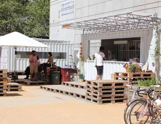
4 Testing Grounds and Arts Centre, City Road
5 Executive Summary The need for a City Road Master Plan The City of Melbourne is leading the development of a draft City Road Master Plan that aims to better balance the road s two key roles as both an important transport link and a people friendly place. This project is a key action from the Southbank Structure Plan, 2010 and responds to the changing role of the road as Southbank grows. Community Engagement Community engagement was conducted from mid-february to mid-march The purpose of the engagement was to raise awareness of the project, develop an understanding of the community s current experiences of City Road and gather information to feed into the development of the draft master plan. The community were invited to share their experiences of City Road online via an interactive map on Participate Melbourne and in person at the Boyd Community Hub during a one-week drop-in in February. Who got involved? In total, 182 experiences were shared via the interactive map on Participate Melbourne by 103 different people (1.8 experiences per person). In addition to describing their experience, people were asked a few simple questions including their age category, why they were on City Road, by what transport mode they were travelling and how the experience made them feel. A summary of the key findings is outlined below: 90 per cent of experiences were negative and 10 per cent were positive experiences. The most common emotion generated by the experiences was unsafe (37 per cent) and frustrated (23 per cent). Participants ranged in age from the age group through to 75+ with the highest level of participation from the age group. Most experiences were shared by pedestrians (50 per cent) followed by cyclists (19 per cent) and drivers/car passengers (19 per cent). The majority of experiences were contributed by residents (66 per cent), followed by workers (12 per cent) and people passing through (9 per cent). What did the community tell us? The current design and layout of City Road present many issues for its users, as summarised below: City Road is an undesirable place to be with 90 per cent of experiences shared by residents being negative and 89 per cent of experiences shared by pedestrians being negative. City Road is a difficult place to get around for all users (pedestrians, cyclists, public transport users and drivers). There is a strong desire to see improvements to City Road. What are the next steps? Information captured in the first phase of community engagement will inform the draft master plan to be released for community engagement later in the year. The focus of the master plan will be on delivering public realm improvements within the road space and footpaths. It will explore options to change the layout and design of the road to address issues such as pedestrian safety, cycling access, transport movement & access, street character and quality, tree planting, water management and public transport provision.
6 1. Introduction Background Southbank is the fastest growing suburb in the City of Melbourne, with a significant amount of large-scale residential and mixed use developments recently completed, under construction or scheduled. This amplifies the need to improve the quality of the public realm in City Road. The City Road master plan will guide public realm improvements towards the creation of a civic spine in line with the Southbank Structure Plan, It will have to address issues relating to both transport and urban design and balance the needs of various users and stakeholders. The City Road Master Plan is identified in Council s Annual Plan 2013/14 as Priority Action Develop a City Road Master Plan in line with Southbank Structure Plan objectives. Scope The focus of the master plan will be on delivering public realm improvements within the road space and footpaths. It will explore options to change the layout and design of the road to address issues such as pedestrian safety, cycling access, transport movement & access, street character and quality, tree planting, water management and public transport provision. Changes to planning controls that affect private land use and development are not within the scope of this project. Study Area & Management City Road is under the shared management of the City of Melbourne and VicRoads. It is a declared arterial route and provides an important connection between Port Phillip Bay and the city. The study area includes the length of City Road within the City of Melbourne, from the West Gate Freeway in the west to St Kilda Road in the east. It also includes Alexandra Avenue to the intersection with Linlithgow Avenue. In total, the length of the road is approximately two kilometres. Process This project is being undertaken in four stages. Community engagement was undertaken as part of Stage 1. Stage 2 will involve the development of a draft master plan which, subject to the approval of the Future Melbourne Committee, will be available for public comment in stage 3. The feedback from the broader community will be considered and will inform a final Master Plan in stage 4. Due to the nature and scale of the project, the City of Melbourne is working with a number of stakeholders. A Steering Committee has been established comprising representatives from VicRoads, the Department of Transport Planning and Local Infrastructure (DTPLI), Public Transport Victoria (PTV), City of Port Phillip and City of Melbourne. Members of these organisations have been involved in two workshops to date to establish key priorities for their organisation, along with collective issues and opportunities for City Road. City Road TimeLine Community Engagement We Are Here Draft Master Plan Community Engagement Final Master Plan 6 melbourne.vic.gov.au/cityroad

7 Community Engagement The City of Melbourne conducted community engagement from mid-february to mid-march During this period, community members were invited to share their experiences of City Road via Participate Melbourne. Many people also joined in the conversation with City of Melbourne officers at the Boyd Community Hub during the week of the 24 February All the information captured through the first stage of engagement will be used to inform the development of a draft City Road Master Plan. This report provides a summary of the key findings from this first phase of community engagement. City Road Alexandra Avenue City Road Figure 1.1: City Road Master Plan Study Area City Road Master Plan Community Engagement Summary June
8 2. Community Engagement Overview Engagement Approach The purpose of the community engagement was to: Raise awareness of the City Road Master Plan Project. Develop an understanding of the community s current experiences of City Road. Gather qualitative data to feed into the development of the draft Master Plan. To achieve these objectives the community engagement consisted of two main components: 1. Participate Melbourne - an online community engagement hub to allow broad participation. This featured an interactive map that allowed the public to share their current experiences of City Road in specific locations along the study area. This was open for contribution for one month from 17 February to 17 March 2014 and generated 1372 visits during this time. 2. A week-long drop-in at the Boyd Community Hub during the week 24 February to 1 March 2014 which allowed the community to discuss the project with City of Melbourne staff and provide comments through Participate Melbourne, written surveys and post-it notes. City Road Master Plan Figure 2.1: Engagement Postcard 8 melbourne.vic.gov.au/cityroad

9 Sharing an experience on the online map, BOYD Spreading the Word The community engagement was promoted by the City of Melbourne through a range of mediums to reach as many people who live on, visit and use City Road as possible, including: Postcards and posters were distributed to the Boyd Community Hub, local businesses and residential towers along City Road. The City of Melbourne website directed visitors to the Participate Melbourne page as well as providing information about the Boyd drop-in. Promotion in the Boyd Community Hub E-Newsletter. Social media featured on City of Melbourne Facebook and Twitter accounts. to key stakeholders. The project was also promoted by external organisations and media outlets including: An editorial in the Southbank News Changes ahead for City Road 17 February Article featured in Urban Melbourne online blog 28 February 2014 entitled City of Melbourne wants people to share their City Road Experiences. Promotion of online engagement by Bicycle Network Victoria in weekly electronic newsletter in the loop. Promotion through CrowdSpot website and electronic newsletter to CrowdSpot networks (including Twitter and Facebook). Media Release 19 February Online Visits to participate Melbourne 103 People shared their experience of city road Via participate 14 People provided written comments via /survey City Road Master Plan Community Engagement Summary June

10 Interactive Map The main community engagement tool was Participate Melbourne, which featured an embedded interactive map of City Road. Participants were able to select a location to pin their experiences on the interactive map. These experiences appeared as green faces representing positive experiences and red faces for negative experiences. Map features included the ability to zoom in to specific locations to see greater street detail, upload images, view other people s experiences and comment on, or support them. It also featured a live activity feed which allowed participants to keep up to date with the latest activity. As well as describing their experience, participants were asked a few simple questions including their age category; why they were on City Road; by what transport mode they were travelling and how their experience made them feel. The data captured allowed for a qualitative analysis of the issues experienced by different users and modes of travel and identification of clusters of negative experiences and problem areas. All quotes within this report are taken from this community engagement exercise. Figure 2.2: Final Interactive Map showing distribution of all negative and positive experiences along the study area and live activity feed on the right hand side of the screen 10 melbourne.vic.gov.au/cityroad

11 182 Spots dropped on THE map 42 COMMENTS on OTHERS EXPERIENCES 399 Supports FOR EXPERIENCES on map Importantly, the interactive map started a public conversation around issues experienced along City Road and some of the potential opportunities for improvement. Contributors went into great detail to describe their experiences. Some experiences generated numerous comments and supports, clearly striking a chord with other users. The comments captured on the map start to show the many competing opinions and how any solution presented in the master plan will have to balance the needs of various road users. Figure 2.3: A negative experience on the interactive map City Road Master Plan Community Engagement Summary June
 projected onto the wall.")
12 Boyd Drop-In During the engagement period, members of the public were invited to a week-long dropin at the Boyd Community Hub on City Road, where they had the opportunity to discuss the City Road Master Plan project with City of Melbourne staff. An informal space was created in the foyer, with the main feature being the interactive map (Participate Melbourne) projected onto the wall. Participants contributed their experiences using the computer and i-pad provided, handwritten surveys, as well as sharing any further thoughts on post-it notes on the City Road notice board. Hosting the event at Boyd allowed for many interesting and insightful discussions with a broad cross section of the community - both those informed about the engagement and those passing by. Many people commented on how Boyd had created a new heart for the growing Southbank neighbourhood thanks to the extensive range of community services offered and the popularity of the cafe for locals, workers and visitors. This sentiment came through in some of the positive experiences shared online. The engagement generated a lot of interest from a well-informed and passionate user group who experience City Road in their day to day lives. Boyd Community Hub drop-in, City Road 12 melbourne.vic.gov.au/cityroad

13 Notes on the City Road Master Plan notice board Figure 2.4 A word cloud from notes posted by the public during the drop-in City Road Master Plan Community Engagement Summary June
14 3. Participants In total, 182 experiences were shared on the online map by 103 different contributors (average of 1.8 experiences per person). Of those 90 per cent were negative and 10 per cent were positive. The most common emotion generated by these experiences was unsafe (37 per cent) and frustrated (23 per cent) while the positive emotions (happy/relaxed/hopeful) were in the minority at only 7 per cent. The engagement generated involvement from the age group right through to 75+, but the highest level of participation was generated by the and age groups. Most experiences were shared by pedestrians (50 per cent), followed by cyclists (19 per cent) and drivers/car passengers (19 per cent). The majority of experiences were contributed by residents (66 per cent), followed by workers (12 per cent) and people passing through (9 per cent). Positive Experiences 10 % Angry Sad happy relaxed hopeful % 37 Unsafe 90 Other Neutral Negative Experiences Frustrated Figure 3.1: Percentage of positive and negative experiences shared online Figure 3.2: Percentage of experiences shared online by emotion 14 melbourne.vic.gov.au/cityroad
15 Who got involved? Figure 3.3: The number of experiences shared online by age of participant Motorcyclists Public Transport Users Other Drivers/ passengers Bike riders Pedestrians Figure 3.4: The number of experiences shared online by mode of transport Business Owner Visitors Other Commuters Students People passing through Workers residents Figure 3.5: The number of experiences shared online by reason for visit City Road Master Plan Community Engagement Summary June
, appreciation of remaining industrial architecture, the street providing for a variety of")
16 4. Positive Experiences People used the positive experience category to share actual experiences as well as ideas to improve City Road. Some of those included praise for community facilities like Boyd and Testing Grounds (see overview opposite), appreciation of remaining industrial architecture, the street providing for a variety of lifestyles, the vibrancy of life in Southbank and proximity to transport and amenities. There was also recognition of recent improvements to the area but a desire to see more. Roughly half of the 19 positive experiences recorded were outlining opportunities for improvements to City Road. There was a strong desire to see more community services and facilities in City Road and Southbank to cater to the local resident population, such as open space, playgrounds, a supermarket and a post office. Improving pedestrian amenity and connectivity, activating the space under Kings Way and providing bike lanes to allow people to cycle safely were all suggestions. Boyd is a safe refuge, however more green parks are needed for kids. Karen, resident I chose to live in this building because of its proximity to transport and amenities like Boyd. Love the vibrancy and ease of life as a pedestrian. Margaret, resident Testing Grounds, City Road 16 melbourne.vic.gov.au/cityroad
 from Southbank and surrounding suburbs including South Yarra and South Melbourne.")
17 Kere Kere Cafe at BOYD, City Road Boyd Community Hub The Boyd Community Hub opened its doors to the Southbank community in July Since then, they have received on average over 7000 visitors per month (approximately 230 per day) from Southbank and surrounding suburbs including South Yarra and South Melbourne. Testing Grounds At the eastern end of City Road is a recent project on the State- Government owned Y-Site known as Testing Grounds. It is a free, openair art space used for a variety of purposes by locals and visitors alike, including recreation space, workshops, art installations, music performances, a bar and food venue (with temporary food trucks). This concept has quickly gained popularity and created a community-focused facility in the eastern end of City Road. Useful community services along the street front such as a post office, chemist, supermarket, doctor/dentist, hardware shop and restaurants which are easily accessible to the local residents would enhance the area. Mark, resident Using vacant land to create temporary public space like Testing Grounds is a fantastic idea. Initiatives like this is why I love Melbourne. Garrath, resident City Road Master Plan Community Engagement Summary June

18 5. Negative Experiences An undesirable place to be During the community engagement, the City of Melbourne asked participants what the main reason was for their visit to City Road. Overwhelmingly, people who commented the most were local residents 120 of a total of 182 comments were made by residents. Of these comments, 90 per cent expressed a negative experience of City Road. Predominantly, these residents were commenting on their experience as pedestrians in the street. In their comments, they emphasised that City Road is not a desirable place to be in. The predominant emotions expressed by this group were unsafe (32 per cent), frustrated (22 per cent), angry (16 per cent) and sad (10 per cent). Sad Other happy relaxed 12 hopeful 8 32 Angry 10 % Unsafe Frustrated Figure 5.1: Emotions expressed by residents on City Road (120 comments) Sturt Street, City Road 18 melbourne.vic.gov.au/cityroad

19 City Road Walking from Whiteman Street (home) to the Boyd Centre - the journey is not a relaxing and pleasant experience as a local resident. There is no feeling of a planned clustering of retail versus food versus office mix. It is a very mixed bag of businesses that do not relate. Importantly, there is no green space or pedestrian friendly pathway to make the journey to the Boyd Centre a pleasant one for local residents. Local Journeyman, resident The noise from the many trucks using City Road is offensive, not only in terms of its decibel level, but also its occurrence throughout the day and night. Truck access to City Road should be restricted, only permitted between the hours of 7am and 7pm. Dan, resident The tramstop and crossing under Kings Way is awful. There is poor drainage which results in the tram stop and pedestrian crossing being flooded after heavy rain. Melanie, visitor This stretch of road should be planted with the same type of plant, shrub or tree to give it a distinctive feel to tie it all in together as one street. It also needs some street furniture or lighting that has a more residential feel. Rodney, resident City Road Master Plan Community Engagement Summary June
20 A difficult place to get around We asked participants what their mode of transport was when using City Road. In order, the people who chose to comment were pedestrians (50 per cent of comments), cyclists (19 per cent) and drivers (19 per cent). A smaller number of comments were also received from motorcyclists, public transports users and others (transport mode not specified). As ninety per cent of all comments were negative, it is fair to conclude that across all transport modes, there is discontent with the experience of people getting around and through City Road. Yarra River Alexandra Avenue Clarendon Street City Road Queens Bridge Street West Gate Freeway Power St City Road Southbank Boulevard Sturt Street St Kilda Road Figure 5.2: Locations of experiences shared on online map 20 melbourne.vic.gov.au/cityroad

21 Alexandra Avenue The area around the tram stop under Kings Way is extremely neglected, but highly utilised. With no convenient crossing, pedestrians and public transport users have to dash across the road without a clear line of sight where traffic is coming from. Leonora, resident If cycling north, turning right onto Balston St is hectic on a bike - hard to get across to the right hand lane, and then stuck in the middle of the road between two busy lanes of traffic. HJ, commuter I m a very experienced cyclist, but this intersection (City Road/ Queens Bridge Street) is one of the scariest in Melbourne. Steve, passing through The traffic build up here (Alexandra Avenue) is consistently congested and causes motorists to take risks. The left lane turning over the bridge is banked up, while the toll lane is often unused. Drivers are stopping, weaving, veering out suddenly. This is a poorly planned road. Marielle, resident City Road Master Plan Community Engagement Summary June
22 The Pedestrian Experience Relaxed/Happy Key Findings City Road is perceived as a significant pedestrian barrier, separating Southbank into two halves, in particular, disconnecting the Arts precinct from the Yarra River precinct. The predominance of traffic (noise, physical proximity) dramatically influences the pedestrian experience of City Road. Generally perceived as an unsafe and frustrating experience for pedestrians. Other Angry Sad % Frustrated Unsafe Figure 5.3: Emotions expressed by pedestrians on City Road (91 comments). Yarra River Alexandra Avenue Clarendon Street City Road Queens Bridge Street West Gate Freeway Power St City Road Southbank Boulevard Sturt Street St Kilda Road Figure 5.4: Location of experiences shared by pedestrians 22 melbourne.vic.gov.au/cityroad

23 Kings Way undercroft, City Road A summary of the issues affecting the pedestrian experience are outlined below. Intersections are particularly challenging for pedestrians - slip lanes increase crossing distances and reduce safety. The walking environment is generally unpleasant and unwelcoming. Key features that contribute to this experience are: Few benches, bins, water fountains, open space. Poor quality materials and finishes. Inconsistent width of footpaths. Poor amenity of undercroft spaces and lack of lighting (West Gate Freeway, Kings Way, St. Kilda Road). Visual clutter of overhead power lines. Perception that vehicles frequently speed, particularly on approach from Alexandra Avenue through St Kilda Road underpass and fail to see pedestrian crossing outside the Mantra hotel. Lack of way finding signage - this is exacerbated by the irregular street pattern in Southbank that makes it difficult to navigate through the suburb. There are few crossing opportunities resulting in people crossing at unsignalised points (e.g. Clarke Street, Alexandra Avenue). Frequency of driveway crossovers - this includes access to off-street car parking which creates potential conflicts between vehicles and pedestrians. Poor connection from St. Kilda Road to City Road. High level of noise from freight and other vehicle traffic. Flooding, particularly at western end of City Road. Few permeable surfaces along City Road. Lack of consistent tree planting. Footpaths blocked off temporarily by construction of new developments. Pedestrian crossing delays at intersections due to long traffic light cycles which prioritise vehicle flow. No automatic pedestrian crossing activation. I feel unsafe using the pedestrian crossing outside the Mantra hotel. You have to make sure the cars are actually stopping before you cross, as I have seen many that don t see the lights and drive through the red. Jane, resident Walking along City Road to Boyd is unpleasant. It doesn t feel like a pedestrian access area. The traffic is high, noise is high, the pollution is evident - therefore it is not a pleasant experience to walk down with children. Marielle, resident City Road Master Plan Community Engagement Summary June
24 The Cycling Experience Key Findings No dedicated cycle infrastructure on City Road or Alexandra Avenue. Generally perceived as unsafe for cyclists. Identified as an alternate east-west route to the congested Southbank Promenade but currently not designed for this role. Sad Frustrated Other 3 9 Positive 9 6 % 74 Unsafe I don t use City Rd on my bike, as I feel unsafe, but I would love to be able to. Jane, resident Figure 5.5: Emotions expressed by cyclists on City Road (35 comments). Yarra River Alexandra Avenue Clarendon Street Queens Bridge Street Power St City Road Southbank Boulevard Sturt Street City Road West Gate Freeway Existing Bicycle network Figure 5.6: Location of experiences shared by cyclists 24 melbourne.vic.gov.au/cityroad


25 Clarendon Street intersection, City Road A summary of the issues affecting the cycling experience are outlined below. There is currently no dedicated bicycle infrastructure/ lanes on City Road or Alexandra Avenue. Southbank Promenade is over crowded with pedestrians and cyclists. An alternative east-west route is required for commuter cyclists. Poor cyclist safety from lack of dedicated cycle infrastructure and fast speed of vehicles. Some cyclists use the footpaths. No intersection priority. Poor signage for cyclists in City Road/ Alexandra Avenue and connecting streets. Existing bike lane on Queens Bridge Street ends before City Road intersection leaving cyclists feeling vulnerable. People want to cycle but currently feel unsafe doing so. Desire to see better east-west bicycle connections through Southbank, particularly once Ferrars Street Primary School opens. Bus lane shared with bikes in City Road (east bound). Bike Paths are lacking along City Road and are needed on both side of the road so that people can travel safely with a clean and healthy means of transport. Angelo, resident Better connections and a cycle lane from Swan Street Bridge along City Road to South Melbourne, would encourage me to use this route on the way home from work instead of dodging pedestrians along Southgate and Southbank resident City Road Master Plan Community Engagement Summary June
26 The Public Transport Passenger Experience Key Findings Limited public transport provision on City Road with no connections to South Melbourne (key destination for locals everyday shopping needs). Interchanges and public transport stops generally perceived to be poor quality, unsafe and lacking visibility. Public transport stops not Disability Discrimination Act compliant. Relaxed/Happy Frustrated Angry Figure 5.7: Emotions expressed by public transport passengers (8 comments) 2 Unsafe Yarra River Clarendon Street City Road Queens Bridge Street 55 West Gate Freeway Power St City Road Southbank Boulevard Sturt Street 1 Alexandra Avenue Bus Routes Tram Routes Figure 5.8: Location of experiences shared by public transport passengers 26 melbourne.vic.gov.au/cityroad
. Lack of way-finding at transport interchanges.")
27 West Gate Freeway undercroft, City Road A summary of the issues affecting the public transport passenger experience are outlined below. Generally limited public transport in comparison to Hoddle grid. Public transport does not connect people to key destinations (e.g South Melbourne Market). Lack of way-finding at transport interchanges. Quality, safety and visibility of public transport interchanges is generally poor (bus stops and tram stops). Poor efficiency of services. Tram stops are not Disability Discrimination Act compliant. Tram stops under Kings Way are very unpleasant and subject to flooding. Public transport is better to the west of Power Street where there is access to two tram routes and buses. There is limited public transport east of Power Street. No public transport that directly connects the Arts Precinct to South Melbourne Market and Port Melbourne / Bay Street. There are a number of older residents in Southbank who depend on public transport. Local resident City bound tram stop feels dangerous at night time. Pigeons use tram travellers as target practice. Not well lit. I often will choose to walk to Flinders and then get a tram and walk an additional 30 mins home than wait for the 55 tram which takes me to my door. Natalie, worker City Road Master Plan Community Engagement Summary June
28 The Driving Experience Key Findings Generally perceived as a frustrating experience. Confusion at intersections around lane selection/way-finding, particularly at Southbank Boulevard and Power Street. Conflicts between local access to off-street car parking, traffic flow and pedestrian activity. Lack of short-term parking near Boyd. Queuing to go over Swan Street Bridge has significant congestion impacts for Alexandra Avenue and back to City Road. Unsafe 22 Angry 28 Helpless 3 % 47 Frustrated Figure 5.9: Emotions expressed by drivers on City Road (34 comments) Yarra River Alexandra Avenue Clarendon Street City Road Queens Bridge Street West Gate Freeway Power St City Road Southbank Boulevard Sturt Street St Kilda Road Figure 5.10: Location of experiences shared by drivers 28 melbourne.vic.gov.au/cityroad

29 Southbank Boulevard intersection, City Road A summary of the issues affecting the driving experience are outlined below. There is a lack of short-term parking for Boyd users. Entry into apartment building car parks off City Road is challenging for drivers. East of Power Street, City Road is used as an alternative to the CityLink Burnley Tunnel for placarded vehicles and over sized vehicles. It is also the alternative route in times of tunnel closure. Perception that vehicles frequently speed on approach from Alexandra Avenue and through St Kilda Road underpass. Drivers emerging from St Kilda Road underpass have difficulty knowing which lane to be in to enter the Hoddle Grid. Swan Street Bridge congestion causes queuing up of traffic along Alexandra Avenue with drivers trying to merge into left lane at last minute. City Road and Alexandra Avenue form a major CityLink exit into the Central City. Consequently, there are far greater traffic flows on these sections of the road often resulting in congestion during peak periods. Drivers often experience confusion over which lane to be in at intersections. Nobody knows which lane to be in at these junctions (Power Street) - the people who want to go straight ahead either get caught in the left turning traffic or sent off to the right as we wanted to avoid the left turners. Very confusing! Lisa, resident Insufficient traffic capacity on Swan Street Bridge causes queuing back along Alexandra Avenue blocking the intersection of Linlithgow Avenue. Dave, worker City Road Master Plan Community Engagement Summary June

30 6. Next Steps Information captured through the first phase of community engagement will inform the draft master plan to be released for formal community engagement later in The master plan will also be informed by key stakeholder priorities and must be considered within the context of a number of background documents, the work of various organisations over the past 10 years including: Southbank Plan, 2006 (Department of Transport Planning and Local Infrastructure) SmartRoads Network Operating Plan, 2012 (VicRoads) Fishermans Bend Urban Renewal Area Draft Vision, 2013 (Places Victoria) Montague Structure Plan, 2012 (City of Port Phillip) Yarra River Corridor Pedestrian and Cycling Safety Plan, 2013 (City of Melbourne) Plan Melbourne, 2014 (Department of Transport Planning and Local Infrastructure) Melbourne Arts Precinct Blueprint, 2014 (Arts Precinct Working Group, State Government of Victoria) Southbank Developer Contribution Plan - Public Realm Design Intent for Streets and Local Centres, 2014 (City of Melbourne) The City of Melbourne has also commissioned a new study to further understand the current traffic and transport issues and opportunities. Register with Participate Melbourne to be kept informed of the City Road Master Plan project - melbourne.vic.gov.au/participate. Pedestrians in City Road
31
 Translation services National Relay Service: If you are deaf, hearing impaired or speechimpaired, call us via the National Relay Service:")
32 How to contact us Online: melbourne.vic.gov.au Telephone: am to 6pm, Monday to Friday (public holidays excluded) Translation services National Relay Service: If you are deaf, hearing impaired or speechimpaired, call us via the National Relay Service: Teletypewriter (TTY) users phone then ask for am to 5pm, Monday to Friday (Public holidays excluded) In person: Melbourne Town Hall - Administration Building 120 Swanston Street, Melbourne 7.30am to 5pm, Monday to Friday (Public holidays excluded) In writing: City of Melbourne GPO Box 1603 Melbourne VIC 3001 Australia Fax: melbourne.vic.gov.au
1. TRANSFORM CITY ROAD WEST INTO A GREAT CENTRAL city street
 1. TRANSFORM CITY ROAD WEST INTO A GREAT CENTRAL city street Understanding City Road West City Road West (between Clarendon Street and ower Street) is a local street, and can be significantly enhanced
City Road draft Master Plan
 City Road draft Master Plan Community engagement summary SEPTEMBER - OCTOBER 2015 participate.melbourne.vic.gov.au/cityroad A connected city We manage movement in and around our growing city to help people
TRAVEL PLAN: CENTRAL EUROPEAN UNIVERSITY CAMPUS REDEVELOPMENT PROJECT TRAVEL PLAN. Central European University Campus Redevelopment Project.
 TRAVEL PLAN Central European University Campus Redevelopment Project Page 1 Table of Contents Introduction... 3 Background... 7 Building Users... 7 Transportation in Community Consultation... 7 Summary
Speed Limits in the Hoddle Grid
 Speed Limits in the Hoddle Grid Recent History of speed limits March 2013 Docs # 7738485 1 Introduction Muncipalities have power to Erect speed limit signs BUT Municipalities DO NOT have the power to approve
AUTOMATED AND ZERO EMISSION VEHICLES HOW THEY MIGHT RESHAPE OUR STREETS
 AUTOMATED AND ZERO EMISSION VEHICLES HOW THEY MIGHT RESHAPE OUR STREETS BACKGROUND: This study is a collaboration between Urban Circus (Visualisation) and Ethos Urban (Urban Design) Ideas were workshopped
AUTOMATED AND ZERO EMISSION VEHICLES HOW THEY MIGHT RESHAPE OUR STREETS
 AUTOMATED AND ZERO EMISSION VEHICLES HOW THEY MIGHT RESHAPE OUR STREETS STURT ST BALLARAT WATERGARDENS TAYLORS LAKES SIMPSON ST YARRAVILLE CHAPEL ST SOUTH YARRA RINGWOOD STATION MONASH FREEWAY SA NSW VIC
Tonight is for you. Learn everything you can. Share all your ideas.
 Strathcona Neighbourhood Renewal Draft Concept Design Tonight is for you. Learn everything you can. Share all your ideas. What is Neighbourhood Renewal? Creating a design with you for your neighbourhood.
LEA BRIDGE ROAD - A STREET FOR EVERYONE Public consultation document
 LEA BRIDGE ROAD - A STREET FOR EVERYONE Public consultation document TELL US Bakers Arms to Leyton Green Road (Section D, E, F) Leyton Green Road to Whipps Cross Roundabout (Section G) YOUR VIEWS www.enjoywalthamforest.co.uk
Submission Cover Sheet Mordialloc Bypass Project EES IAC
 Submission Cover Sheet Mordialloc Bypass Project EES IAC 61 Request to be heard?: yes Full Name: Organisation: Affected property: Attachment 1: Attachment 2: Attachment 3: Comments: Lucinda Bertram Aspendale
Welcome! Public Open House on UBC s Transportation Plan
 1 Welcome! Public Open House on UBC s Transportation Plan Public open house hours: to When it comes to on-campus transportation, what do you think is working well and what are some opportunities for improvement?
2. Context. Existing framework. The context. The challenge. Transport Strategy
 Transport Strategy Providing quality connections Contents 1. Introduction 2. Context 3. Long-term direction 4. Three-year priorities 5. Strategy tree Wellington City Council July 2006 1. Introduction Wellington
BYRES ROAD: PUBLIC REALM Public Consultation
 Public Consultation Introduction As a vibrant commercial, shopping and residential location within the heart of the West End Byres Road is an important destination. Its proximity to the University of Glasgow
122 Avenue: 107 Street to Fort Road
 : 107 Street to Fort Road November 24, 2015 4:30 8:00 p.m. Meeting Purpose Summarize project work completed to date Share results of public input from Phase 1 Share the draft concept plan and proposed
SH3 Waitara to Bell Block
 SH3 Waitara to Bell Block NZ Transport Agency August 2017 Community feedback report Copyright information This publication is copyright NZ Transport Agency. Material in it may be reproduced for personal
High frequency bus services operating to Little Island; Creation of a new Park and Ride site and train station at North Esk;
 Cork County Council 7 th December 2018 Dear Adrian O Neill (aoneill@jbbarry.ie) The Transport and Mobility Forum, Cork (TMF) is a representative group of organisations who have a common interest in sustainable
21.07 TRANSPORT CONNECTIVITY AND INFRASTRUCTURE
 21.07 TRANSPORT CONNECTIVITY AND INFRASTRUCTURE 21.07-1 Connectivity and Choice Transport connectivity and mode choice are critical to achieving productive, sustainable and socially just cities. Travel
Bristol City Council has produced a draft Bristol Transport Strategy document.
 Bristol Transport Strategy Summary Document Introduction Bristol City Council has produced a draft Bristol Transport Strategy document. The Strategy fills a gap in transport policy for Bristol. We have
Douglas Land Use and Transportation Strategy (DLUTS) Summary. August 2013
 Summary. August 2013") Douglas Land Use and Transportation Strategy (DLUTS) Summary August 2013 Background Douglas is a large and popular residential suburb of approximately 30,000 persons on the periphery of Cork City along
Douglas Land Use and Transportation Strategy (DLUTS) Summary August 2013 Background Douglas is a large and popular residential suburb of approximately 30,000 persons on the periphery of Cork City along
Baseline Survey of New Zealanders' Attitudes and Behaviours towards Cycling in Urban Settings
 Baseline Survey of New Zealanders' Attitudes and Behaviours towards Cycling in Urban Settings Highlights 67% of urban New Zealanders, 18 years of age or more own or have access to a bicycle that is in
Your views are important. Please fill in a form before you leave. Or alternatively
 Drum Property Group is delighted to welcome you to this exhibition which sets out our initial proposals for a mixed-use development at Stead s Place, Edinburgh. We are keen to hear the views of local people
City of Perth Cycle Plan 2029
 Bicycling Western Australia s response City of Perth Cycle Plan 2029 2012-2021 More People Cycling More Often ABOUT BICYCLING WESTERN AUSTRALIA Bicycling Western Australia is a community based, not-for-profit
Launceston's Transport Futures. Greater travel options for the people of Launceston
 Launceston's Transport Futures Greater travel options for the people of Launceston Final Draft 13 Jan 2014 1 Page Number Executive summary 3 What is Transport Futures? 4 Vision 6 Economy, access and liveability
Governance and Priorities Committee Report For the July 2, 2015 Meeting
 CITY OF VICTORIA For the July 2, 2015 Meeting To: Governance and Priorities Committee Date: From: Subject: Brad Dellebuur, A/Assistant Director, Transportation and Parking Services Executive Summary The
Bikeway action plan. Bicycle Friendly Community Workshop March 5, 2007 Rochester, MN
 Bikeway action plan Summary The was held on March 5, 2007 at the Rochester Mayo Civic Center. The workshop was hosted by Rochester-Olmsted County Planning Department in collaboration with the League of
University of Victoria Campus Cycling Plan Terms of Reference. 1.0 Project Description
 University of Victoria Campus Cycling Plan Terms of Reference 1.0 Project Description The Campus Cycling Plan, a first for the University, will provide a comprehensive and coordinated approach to support
Terwillegar Drive Expressway Draft Concept Plan
 Terwillegar Drive Expressway Draft Concept Plan Anthony Henday Drive to Whitemud Drive November 28 5:00-8:00 p.m. December 1 10:00 a.m. - 3:00 p.m. Let s Talk Today you can: Learn about the new direction
Centennial Neighbourhoods Transportation Management Plan Summary of Phase 1 Consultation. Overview of Issues
 1 Centennial Neighbourhoods Transportation Management Plan Summary of Phase 1 Consultation The Centennial Neighbourhoods Transportation Management Plan (CNTMP) is being undertaken to support the Secondary
GLEN EIRA CITY COUNCIL. MURRUMBEENA Transforming our neighbourhood together our concepts based on your ideas
 GLEN EIRA CITY COUNCIL MURRUMBEENA Transforming our neighbourhood together our concepts based on your ideas 1 WHAT HAVE WE HEARD? WHAT NOW? Stage one Tell us what you love about your shopping strip November
Pre-Plan Consultation Summary
 Transportation Master Plan Pre-Plan Consultation Summary Thursday July 7, 2011 Presentation ti Outline Consultation Objectives Scope of Consultation Who Responded? What did we hear? How well did we connect?
Tuesday, September 25 th Mount Holly Municipal Complex 400 East Central Avenue 5:30pm to 7:30pm. Activity Stations o Where do you Live?
 Meeting Information Overview The public workshop for the Mount Holly Comprehensive Bicycle Plan occurred on September 25, 2018. The drop-in workshop allowed attendees to participate in a series of interactive
DRAFT for a State Policy for Healthy Spaces and Places
 DRAFT for a State Policy for Healthy Spaces and Places 1 DRAFT State Policy for Healthy spaces and Places 1. Purpose To encourage the use and development of land that builds healthy communities through
How walk, bike, and transit friendly is your neighbourhood?
 How walk, bike, and transit friendly is your neighbourhood? What is an 8-80 City? 8-80 Cities are communities built for everyone regardless of age or ability. These communities reflect social equality
Devonport City Cycling Network Strategy
 Devonport City Cycling Network Strategy 2010-2013 Devonport City Cycling Network Strategy Introduction In February 2010 a draft master plan for cycleways was presented to the community. The feedback received
Comments The Plan for Port Whitby
 Comments The Plan for Port Whitby April 24th, 2013 Community Meeting #2 Summary Report Prepared by GLPi April 29th, 2013 1 Introduction The purpose of the Port Whitby Secondary Plan Update, Community Improvement
Frome Street Bicycle Route
 The Adelaide City Council invites engagement from the community about Frome Street Bicycle Route Project Summary Adelaide City Council is seeking feedback on design options to construct bicycle facilities
E4 Cycle Route Exeter University to Redhayes Bridge. - Recommendations from Exeter Cycling Campaign
 E4 Cycle Route Exeter University to Redhayes Bridge - Recommendations from Exeter Cycling Campaign 1.0 Introduction Exeter Cycling Campaign has prepared this report to provide recommendations for Devon
CLOSED. The draft concept design has been broken down into 5 categories for the purpose of this survey:
 Old Strathcona s neighbourhood renewal process is now at the draft concept design phase. Over the last several months, the city has been gathering local knowledge and resident input that has been used
Design Workshops Summary of all Feedback January 2017
 Histon Road Corridor Design Workshops Summary of all Feedback January 2017 CITY DEAL AND GROWTH Commitment to Growth: Government, County, City and District Emerging Local Plans: 33,000 new homes 45,000
4.1 Introduction. 4.2 Aspects of walkable communities
 4 Community walkability Community walkability Making communities walkable Urban form Feeling secure 4.1 Introduction Walkability describes the extent to which the built environment is walking-friendly.
Exhibit 1 PLANNING COMMISSION AGENDA ITEM
 Exhibit 1 PLANNING COMMISSION AGENDA ITEM Project Name: Grand Junction Circulation Plan Grand Junction Complete Streets Policy Applicant: City of Grand Junction Representative: David Thornton Address:
Classification Criteria
 SCHEDULE D TO RECOMMENDED OFFICIAL PLAN AMENDMENT NO. 40 SCHEDULE C-4 Road Criteria Criteria Traffic Service Objective Land Service/Access Typical Daily Traffic Volume Flow characteristics Travel Speed
UNDERSTANDING WALKING NETWORKS TO ENABLE SMARTER CHOICES IN TRANSPORT PLANNING IN DUNDEE. Gillian Iversen Atkins
 UNDERSTANDING WALKING NETWORKS TO ENABLE SMARTER CHOICES IN TRANSPORT PLANNING IN DUNDEE Gillian Iversen Atkins 1. INTRODUCTION 1.1. Smarter Choices, Smarter Places The Smarter Choices agenda encourages
Strategy for Walking & Cycling Action Plan
 Strategy for Walking & Cycling Action Plan To achieve higher levels of walking and cycling activity, the destinations which people access have to be available within suitable distances and designed to
City of Toronto Complete Streets Guidelines
 Round One This is a summary of the Complete Streets Guidelines Survey posted on June 18 th, 2015 and live until July 2 nd, 2015. The survey was designed to solicit feedback on the draft Complete Streets
PERSONALISED TRAVEL PLANNING IN MIDLETON, COUNTY CORK
 PERSONALISED TRAVEL PLANNING IN MIDLETON, COUNTY CORK Elaine Brick Principal Transport Planner AECOM Abstract Smarter Travel funding was awarded to the Chartered Institute of Highways and Transportation
Living Streets response to the Draft London Plan
 Living Streets response to the Draft London Plan Contents Living Streets response to the Draft London Plan... 1 About Living Streets... 2 Summary... 2 Consultation response... 3 Chapter 1: Planning London
MILTON ROAD LLF PROJECT UPDATE
 Greater Cambridge City Deal MILTON ROAD LLF PROJECT UPDATE 9 th May 2017 Project objectives Comprehensive priority for buses in both directions wherever practicable; Additional capacity for sustainable
FAQ s Walsh Road / Ferguson Road Pilot Scheme
 FAQ s Walsh Road / Ferguson Road Pilot Scheme What is happening? Traffic calming measures are being installed as a pilot. Temporary Bollards will be installed to the east of 1 Ferguson Road and a Temporary
Nanaimo Transportation Master Plan. Phase 1 Consultation Summary
 Nanaimo Transportation Master Plan Phase 1 Consultation Summary Transportation Advisory Committee Meeting Wednesday December 12, 2012 Agenda Study Update Phase 1 Consultation Process Phase 1 Consultation
Bicycle Facilities Planning
 Bicycle Facilities Planning Overview Types of Cyclists Purpose for Riding Types of Facilities Bike Lanes Bicycle Boulevards Cycle Tracks Intersections Signals Signing and Marking Discussion Types of Bicyclists
Introduction. Prince Street Cycling Ambition Fund Public Realm Project
 Introduction The (CAF) project will create a high quality, 8-80 s cycle route up the west side of Prince Street from Cumberland Road, over Prince Street bridge to the Centre. This is part of the City Centre
CHECKLIST 2: PRELIMINARY DESIGN STAGE AUDIT
 CHECKLIST 2: PRELIMINARY DESIGN STAGE AUDIT 2.1 General topics 2.1.1 Changes since previous audit Do the conditions for which the scheme was originally designed still apply? (for example, no changes to
Mumford Terminal Replacement Opportunities Neighbourhood Open House. we are here. PHASE 2 Identifying and Evaluating Candidate Sites
 Welcome Replacement Opportunities Neighbourhood Open House. AGENDA PURPOSE 1. REVIEW the information boards 2. DISCUSS aspects of the project with the project team 3. SHARE your thoughts on replacement
CHIEF PEGUIS TRAIL EXTENSION WEST
 1 PRELIMINARY DESIGN OF THE CHIEF PEGUIS TRAIL EXTENSION WEST Public Information Session June 6, 2017 Welcome 1 Thank you for attending today s public information session. The following boards provide
Creating walkable, bikeable and transit-supportive communities in Halton
 Creating walkable, bikeable and transit-supportive communities in Halton By presenting current research and best practices, the information in this paper is meant to support and broaden discussion on how
Transportation Assessment
 Transportation Assessment Midtown Open House February 10, 2018 Overview Midtown in Focus Overview & Purpose of Today Transportation Assessment overview Summary of Transportation work to date Review & Analysis
NEW TOWN RETAIL PRECINCT UPGRADE
 The City of Hobart is seeking feedback from the community on the streetscape concept for the New Town Retail Precinct upgrade project. The concept designs have been developed by the City of Hobart in response
IAN WHITE ASSOCIATES. Crawley Station Gateway Public Realm
 IAN WHITE ASSOCIATES Crawley Station Gateway Public Realm contents 1. objectives & client brief 2. site appraisal 3. best practice guidance 4. design concept 1. objectives & client brief Crawley Train
o n - m o t o r i z e d transportation is an overlooked element that can greatly enhance the overall quality of life for the community s residents.
 N o n - m o t o r i z e d transportation is an overlooked element that can greatly enhance the overall quality of life for the community s residents. 84 Transportation CHAPTER 11 INTRODUCTION Transportation
Update June 2018 OUR 2017 PUBLIC ENGAGEMENT
 Update June 2018 Hi, Let s Get Wellington Moving (LGWM) is developing a Recommended Programme of Investment (RPI) that meets our programme objectives and supports the city s and region s growth. As part
A CHANGING CITY. of Edmonton, it is essential that it reflects the long-term vision of the City.
 A CHANGING CITY By the year 2040, Edmonton will be home to more than 1 million people. To accommodate growth and support a healthy and compact city, we need a new approach to development/redevelopment
CITY OF BLOOMINGTON COMPLETE STREETS POLICY
 CITY OF BLOOMINGTON COMPLETE STREETS POLICY POLICY OBJECTIVE: The City of Bloomington will enhance safety, mobility, accessibility and convenience for transportation network users of all ages and abilities,
DESIGN CODE. Enterprise West Harlow London Road North Design Code 21
 DESIGN CODE Enterprise West Essex @ Harlow London Road North Design Code 21 4 MAXIMUM BUILDING HEIGHTS 4.1 Table 4A sets out maximum building height standards for each character area within the LDO boundary.
Berwick Health and Education Precinct: Casey Amendment C207 (Part 1) Submission to Planning Panels Victoria
 Submission to Planning Panels Victoria") Berwick Health and Education Precinct: Casey Amendment C207 (Part 1) Submission to Planning Panels Victoria August 2018 CONTENTS 1 Executive summary... 1 2 Summary of the amendment... 2 3 Submission...
Berwick Health and Education Precinct: Casey Amendment C207 (Part 1) Submission to Planning Panels Victoria August 2018 CONTENTS 1 Executive summary... 1 2 Summary of the amendment... 2 3 Submission...
NOTES FROM JUNIOR COUNCIL ORIENTATION SESSION HELD ON MONDAY, JANUARY 22, 2018, AT 3:30 PM IN COUNCIL CHAMBERS, CITY HALL
 CITY OF KAMLOOPS Junior Council Meeting Agenda March 12, 2018, at 3:30 pm in Council Chambers, 7 Victoria Street West, Kamloops, BC Page 1. APPROVAL OF THE AGENDA 2. MINUTES Attachment Recommendation:
HAMILTON BIKING PLAN OUR VISION: A BIKE FRIENDLY CITY
 HAMILTON BIKING PLAN 2015-2045 OUR VISION: A BIKE FRIENDLY CITY INTRODUCTION Biking as a travel option is experiencing a resurgence internationally and in New Zealand, growing as a familyfriendly and healthy
Public Event 1 Community Workshops
 Public Event 1 Community Workshops Nov. 24 & Dec. 3, 2016 Welcome Workshop Purpose We re looking to you for ideas and insights to help guide future transportation infrastructure planning in the Park Lawn
March Maidstone Integrated Transport Strategy Boxley Parish Council Briefing Note. Context. Author: Parish Clerk 2 March 2016
 Context. Author: Parish Clerk 2 The Draft Integrated Transport Policy (DITS) sets out a vision and objectives, and identifies a detailed programme of interventions to support the Maidstone Borough Local
CHAPTER 3: Vision Statement and Goals
 Davidson Walks & Rolls: Active Transportation Master Plan CHAPTER 3 Contents: Overview Vision Statement Measurable Goals Public Outreach CHAPTER 3: Vision Statement and Goals Overview The vision statement
STONY PLAIN ROAD STREETSCAPE
 Jasper Place Revitalization Strategy: Vision The people involved in the Jasper Place Revitalization Strategy envision: Goal 1: Feeling safe in our community Create a community where feeling safe is common--where
Hamilton Transportation Master Plan Public Consultation. Public Information Centre One Summary
 Hamilton Transportation Master Plan Public Consultation Public Information Centre One Summary Table of Contents Introduction 1 Purpose 2 What Was Presented 2 Who Came to the Meeting 2 The Breakout Sessions
Byron Avenue. Public Meeting. Thursday June 16, Traffic Calming Design Sherbourne Road to Island Park Drive
 Byron Avenue Traffic Calming Design Sherbourne Road to Island Park Drive Public Meeting Thursday June 16, 2016 Our Lady of Fatima Parish 153 Woodroffe Avenue 6 9pm 1 Project Summary Area Projects Background
Chelmsford City Growth Package
 Chelmsford City Growth Package Public Consultation Document Volume 2 West Chelmsford July - August 2017 Chelmsford City Growth Package Public Consultation Document - Volume 2 - West Chelmsford Contents
5. RUNNINGWAY GUIDELINES
 5. RUNNINGWAY GUIDELINES These guidelines should be considered collectively when making runningway decisions. A runningway is the linear component of the transit system that forms the right-of-way reserved
Travel Planning WC & NWCD Cycling Group. Thursday 2 nd July Amanda Holden
 Travel Planning WC & NWCD Cycling Group Thursday 2 nd July Amanda Holden 1 Today s workshop What is Travel Planning? University Travel Plan NWCD Travel Plan Targets Cycling Initiatives Other Travel Plan
Ormond & McKinnon Walks Response to Draft Glen Eira Community Plan
 Response to Draft Glen Eira Community Plan We would like to take this opportunity to thank Glen Eira City Council for the opportunity to comment on the Glen Eira Draft Community Plan. Below is an outline
Transit boulevard: A new road type for Sydney s Growth Centres
 Transit boulevard: A new road type for Sydney s Growth Centres Cleaver, M. A., de Roos, M. P., NSW Centre for Road Safety, Roads and Traffic Authority, NSW Collins, G., Network Services, Roads and Traffic
Active Transportation Facility Glossary
 Active Transportation Facility Glossary This document defines different active transportation facilities and suggests appropriate corridor types. Click on a facility type to jump to its definition. Bike
George Street Concept Design
 George Street Concept Design City of Sydney with Gehl Architects This document sets out the design principles that will guide the detailed design of George Street. It outlines strategies and concepts for
Physical Implications of Complete Streets Policies
 Presentation Overview Physical Implications of Complete Norm Cox, ASLA, LLA Landscape Architect Ann Arbor, Michigan, 10:45 to Noon What Are Complete Streets? What Matters to Bicyclists and Pedestrians
Active Travel Towns Funding Scheme Project Proposal. Sligo. Sligo Local Authorities
 Active Travel Towns Funding Scheme 2014-2016 Project Proposal for Sligo by Sligo Local Authorities Introduction Over the last two years, Sligo Local Authorities have implemented years 1 & 2 of their 5
Neighbourhood Walkability Checklist How walkable is your community?
 Template letter This template is a guide to writing to your local council. You can change it in any way you feel necessary. Don t forget to attach the checklist and any photographs, maps or sketches you
4 DISRUPTION MANAGEMENT PLAN HIGHWAY 7 RAPIDWAY CONSTRUCTION BETWEEN BAYVIEW AVENUE AND WARDEN AVENUE TOWNS OF MARKHAM AND RICHMOND HILL
 4 DISRUPTION MANAGEMENT PLAN HIGHWAY 7 RAPIDWAY CONSTRUCTION BETWEEN BAYVIEW AVENUE AND WARDEN AVENUE TOWNS OF MARKHAM AND RICHMOND HILL The Transportation Services Committee recommends the adoption of
Active Travel Survey for Bridgend and Pencoed towns. Page description:
 Active Travel Survey for Bridgend and Pencoed towns Page description: Bridgend County Borough Council want to hear from you on how you think we can improve facilities for walking and cycling in and around
Background. Caversham a vision for the future. Joint public meeting arranged by:
 Joint public meeting arranged by: Sharing our Streets Caversham a vision for the future and Caversham Traders Association This presentation followed a presentation by Simon Beasley, Network Manager for
50 Avenue S.W. Corridor Study Glenmore Aquatic Centre Drop-In Event
 Project overview The City of Calgary is conducting a transportation corridor study of 5 Avenue S.W., between Crowchild Trail and 4A Street S.W. In 29, it was reclassified as a Parkway under the Calgary
Lee s Summit Road Improvement Study Public Open House June 7, 2007 Summary of Comment Card Responses
 Lee s Summit Road Improvement Study Public Open House June 7, 2007 Summary of Comment Card Responses Introduction At the Lee s Summit Road Improvement Study Public Open House held Thursday, June 7, 2007
CLOSED. Highlights of the Final Concept Design:
 The final Concept Design is the result of many months of listening, learning, creating, balancing, and understanding different needs and viewpoints, as well as incorporating technical requirements and
Complete Streets for Niagara A working method to visualize the creation of a complete street June 20th, 2013
 Complete Streets for Niagara A working method to visualize the creation of a complete street June 20th, 2013 C O N T E N T S Introduction and background of the report What is a complete street? What can
Winnipeg Walk Bike Projects Downtown Tire Talk - Summary
 Winnipeg Walk Bike Projects Downtown Tire Talk - Summary Downtown Projected Bike Lane System Connecting The Forks to the Exchange District (Fort Street, Garry Street & The Forks to Assiniboine Connection)
St Elizabeth s Primary School
 St Elizabeth s Primary School 55 Effingham St, Tarrangindi QLD 4121 2 Table 1: School overview School Name: St Elizabeth s Primary School Address: 55 Effingham St, Tarragindi, QLD 4121 Grades at the school:
AIRPORT ROAD ENVIRONMENTAL ASSESSMENT
 WELCOME TO PUBLIC INFORMATION CENTRE #1 AIRPORT ROAD ENVIRONMENTAL ASSESSMENT From Braydon Boulevard/Stonecrest Drive to Countryside Drive November 23, 2017 6:30 PM 8:30 PM Please sign in and fill out
RESOLUTION NO ?? A RESOLUTION OF THE CITY OF NEPTUNE BEACH ADOPTING A COMPLETE STREETS POLICY
 RESOLUTION NO. 2018-?? A RESOLUTION OF THE CITY OF NEPTUNE BEACH ADOPTING A COMPLETE STREETS POLICY WHEREAS, safe, convenient, and accessible transportation for all users is a priority of the City of Neptune
Pattullo Bridge Replacement Project Community Connections Phase 2 Consultation. Appendix 3: Open House Display Boards
 Replacement Project Community Connections Phase 2 Consultation Appendix 3: Open House Display Boards November 2016 Welcome! Welcome to the Replacement Project Public Open House We Want to Hear from You
Circulation in Elk Grove includes: Motor vehicles, including cars and trucks
 Circulation, as it is used in this General Plan, refers to the many ways people and goods move from place to place in Elk Grove and the region. Circulation in Elk Grove includes: Motor vehicles, including
CONNECTING PEOPLE TO PLACES
 CONNECTING PEOPLE TO PLACES 82 EAST BENCH MASTER PLAN 07 Introduction The East Bench transportation system is a collection of slow moving, treelined residential streets and major arteries that are the
EXECUTIVE SUMMARY Callan Park accommodates travel from a wide range of transport modes, including walking, cycling, bus and light rail.
 TRANSPORT AND ACCESS EXECUTIVE SUMMARY Callan Park accommodates travel from a wide range of transport modes, including walking, cycling, bus and light rail. Whilst there are some walking facilities within
Major Bike Routes 102 Avenue Workshop April 21, 2015
 Major Bike Routes 102 Avenue Workshop April 21, 2015 Our Purpose Today Provide context on how Major Bike Routes fit into Edmonton s future Share information on what we heard in our last phase, and how
Broad Street Bicycle Boulevard Design Guidelines
 Broad Street Bicycle Boulevard Design Guidelines Building from the strategies introduced in the 2013 Bicycle Transportation Plan and community input received thus far, City Transportation Staff have identified
Saskatchewan Drive Roadway Rehabilitation and Shared-Use Path Widening
 Saskatchewan Drive Roadway Rehabilitation and Shared-Use Path Widening We are here today to present the draft plan for the Saskatchewan Drive Roadway Rehabilitation and Shared-Use Path Widening project