Waterfront Trail; Lynde Creek to Pickering
|
|
|
- Arthur Casey
- 5 years ago
- Views:
Transcription
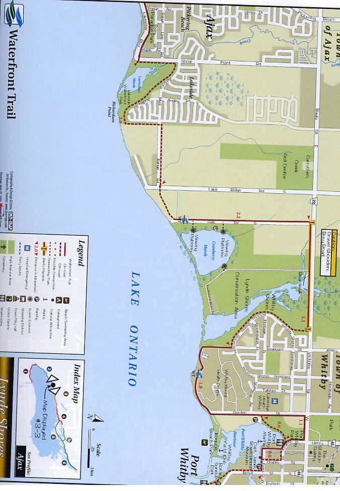
1 Waterfront Trail; Lynde Creek to Pickering Ride starts at Lynde Creek C.A., Whitby Victoria St. (caution - busy road!) Halls Rd gravel path gravel path (towards Lk. Ontario) Driving Directions to Lynde Creek Conservation Area *Highway 401 to Brock Rd., Whitby *South on Brock Rd. for 300 m to Victoria St. *West on Victoria St. for 2.7 km. *Look for Conservation Area sign on the south side of the road Ontario Blvd Waterfront Trail (unmarked) Waterfront Trail (unmarked) Shoal Point Rd Waterfront Trail (unmarked) Waterfront Trail (unmarked) keep following Lake Ontario! Duffin's Creek Bridge (town of Pickering) Waterfront Trail Waterfront Trail (at Brock Rd.) follow W-T signs for next 4.3 km! Bayly Rd. busy road - follow sidewalk! (turn right for Tim Hortons! Waterfront Trail (at Gingerbread Nursery Sch.) follow W-T signs for next 4.9 km! Rouge Beach Park (city of Scarborough) 2006 Ganaraska Freewheelers (
2
3
4
. 25 km Lawrence Avenue. After 12 km of battling the traffic along Kingston Road, you will arrive at the Lawrence Avenue intersection.")
. Lawrence Avenue starts off quite busy, but becomes progressively quieter as it heads east.")
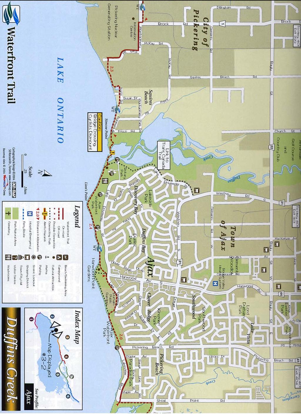
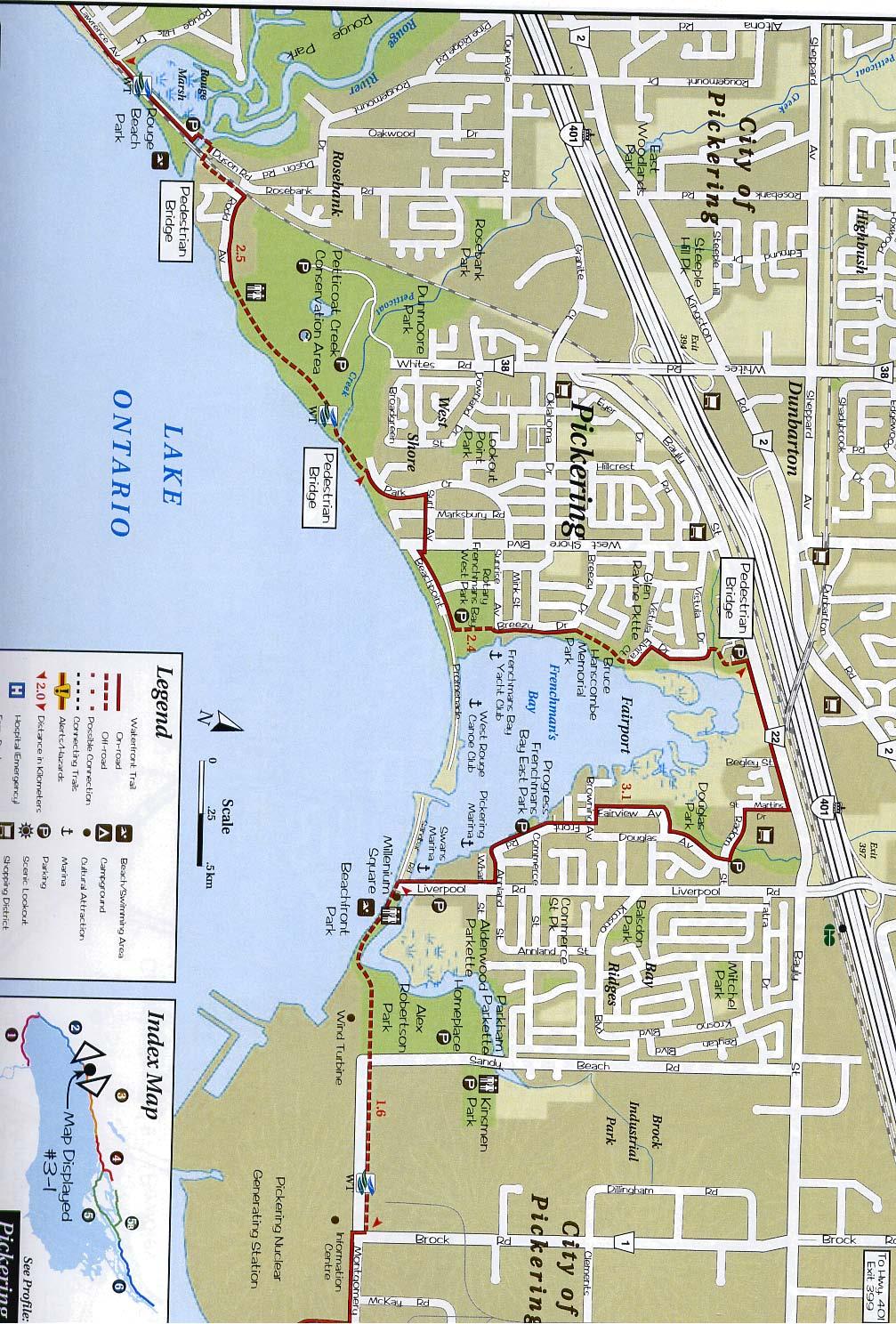
5 Toronto to Oshawa Page 2 of 4 05/10/2006 Kingston Road will be the worst that you will encounter between Toronto and Montréal! 24 km Guildwood train station (VIA and GO). 25 km Lawrence Avenue. After 12 km of battling the traffic along Kingston Road, you will arrive at the Lawrence Avenue intersection. Try and not miss this one since you need to turn right here. There is a McDonald's restaurant at the intersection, and if you notice the Morningside Mall you have gone too far! (In a further 2 km, Kingston Road becomes a divided highway that funnels traffic directly onto Highway #401). Lawrence Avenue starts off quite busy, but becomes progressively quieter as it heads east. 30 km Rouge Hill GO station. Lawrence Avenue now becomes two lanes and much quieter. By now you could be wondering if you will ever make it through the city to the Town of Pickering. If 30 km of urban cycling is not your cup of tea, there is an inexpensive alternative, and that is to take the 'GO Train' from Toronto's Union Station to the Rouge Hill station. You can take your bike on the train at most, but not all, times. 31 km Lawrence Avenue ends at Rouge Hills Rd., and straight ahead you will see the road to the Rouge Beach Park. The road ends at the Rouge River, but there is a pedestrian bridge across it. 32 km Turn right immediately after crossing the bridge and head under the train tracks, as this is where the Waterfront Trail recommences. You will, however, have to climb a few steps and traverse a 25 metre section of dirt before turning left on Bella Vista Road and then (almost immediately) right on Rodd Avenue. It is important that you follow the Waterfront Trail for the next 16 km, so be sure to watch for the blue/green signs! 33 km The Waterfront Trail heads into the Petticoat Creek Conservation Area and becomes a designated trail for the next kilometre. 34 km Shortly after crossing Petticoat Creek on a desigated cycling/hiking bridge, the Waterfront Trail follows a mixture of quiet suburban streets and desigated trails along the west shore of Frenchman's Bay until it reaches busy Bayly Street. 36 km Bayly Street. For the next kilometre, you will have no choice but to follow busy Bayly Street as it heads east adjacent to Highway #401. There is, however, a footpath on the south side of the road that you may wish to use. 37 km Be sure to turn right on St. Martin's Street (and not on Begley Street) and then follow the Waterfront Trail as it winds its way through quiet residential streets en route to Lake Ontario. 39 km When you reach Lake Ontario, you will find that there is a dedicated trail along the waterfront that takes you right past the largest wind turbine in North America. This wind turbine is part of the Pickering Nuclear Power Station complex 40 km Alex Robertson Community Park. and the Pickering Nuclear Generating

6 Toronto to Oshawa Page 3 of 4 05/10/2006 Station. The Information Centre at the power station is open from Monday to Friday. Tours are possible, but must be pre-arranged by calling At the power station, there is an excellent paved bike path immediately north of the road. 41 km Brock Road. Here, the bike path crosses over to the south side of the road. 42 km The road ends, but the bike path continues to head east through a delightfully wooded area, very close to Lake Ontario. 44 km Duffin's Creek, where you cross from Pickering to Ajax. Once in Ajax, you will find yourself riding on a paved trail almost on the edge of Lake Ontario. You will quickly realize that the City of Ajax has done an excellent job at preserving its Lake Ontario waterfront. 45 km Ajax Waterfront Park. 48 km The designated trail now heads north (away from Lake Ontario) for a short distance before merging with Shoal Point Rd. After 100 m of road riding (and shortly after crossing a bridge) look for the paved trail to resume on your right. If you come to Ashbury Blvd., you have gone too far! 50 km At the end of the housing development you will come to a fork in the trail. Continue to ride east along the (new and unmarked) trail that follows the Lake Ontario shoreline. 51 km The trail ends at Lakeridge Rd. where you turn left and head north, away from the lake. 53 km Turn right at the lights on to Durham Rd. 22 (Victoria Street). This is a very busy road with no paved shoulder, and you must travel east on it for the next 2 km. You are now in the town of Whitby 54 km Lynde Shore Conservation Area. Between here and Bowmanville there are numerous protected wetlands. Great if you are a bird watcher! 55 km After battling the traffic of Victoria St. for 2 km, you will come to a set of lights and Seaboard Gate (a road), where you will turn right. Be sure to turn right again after cycling for a mere 200 m onto Whitby Shores Greenway, and in a further 200 m you will notice a paved trail to the right of the road. Follow this trail in the same direction (south-west) as you were riding. 56 km The paved trail now heads away from the subdivision and follows the marsh south towards Lake Ontario. You will find yourself riding between the lake and the Whitby Mental Health Centre (to the north). 58 km As you leave the Whitby Mental Health Centre lands, you should follow the paved trail on the right-hand side of the road (Gordon Street). In another 500 m, the Waterfront Trail turns east through parkland. Be sure to follow the Waterfront Trail signs all the way from here to Oshawa. 59 km Port Whitby harbour. Follow the Waterfront Trail signs through quiet residential streets for the next kilometre. 60 km The paved trail re-commences and becomes the Whitby Lions Promenade. 61 km Rotary Sunrise Lake Park (at Lake Ontario). The Waterfront Trail leaves this scenic area by following a boardwalk along the beach. After 300 m of boardwalk, you will reach Heydenshore Park. This is a delightful section as you have 6 km of dedicated trail that runs primarily through parkland.
Durham Region Cycling Coalition DRCC. Promoting Safe Cycling Throughout Durham Region
 Durham Region Cycling Coalition DRCC Promoting Safe Cycling Throughout Durham Region Who Are We? Founded in 2015, as a voice for the Region s 5 largest cycling clubs (1,500 + active members) Oshawa Cycling
Comments The Plan for Port Whitby
 Comments The Plan for Port Whitby April 24th, 2013 Community Meeting #2 Summary Report Prepared by GLPi April 29th, 2013 1 Introduction The purpose of the Port Whitby Secondary Plan Update, Community Improvement
Welcome and Purpose of Meeting
 Welcome and Purpose of Meeting Waterfront Trail Connection Lake Shore Cycling Improvements There is a gap in the Waterfront trail along Lake Shore Blvd West between Norris and First St We are looking at
distance 96km (60m) easy
 easy") Experience Rating easy distance 96km (60m) Cycling route: 96km (60 miles) Cycling in: The Great Waterway, Stormont, Dundas and Glengarry Number of days cycling: 2 Recommended number of nights stay: 2 Experience
Experience Rating easy distance 96km (60m) Cycling route: 96km (60 miles) Cycling in: The Great Waterway, Stormont, Dundas and Glengarry Number of days cycling: 2 Recommended number of nights stay: 2 Experience
STAGE #3 TRANSITION 1 at Camp Keystone
 STAGE #3 SWIM STAGE #3 TRANSITION 1 at Camp Keystone Mount bike AFTER bump T1 Changing Tent STAGE #3 Camp Keystone to Marineland 68 MILE BIKE STAGE #3 68 MILE BIKE Mile 0-10 SAG 0.0 Turn RIGHT out of T1.
Town of Whitby Official Plan Review OVERVIEW
 Town of Whitby Official Plan Review Presentation at Special Meeting of Council Whitby (Municipal Building) November 28 th, 2007 Brooklin (St. Thomas Anglican Church) December 6 th, 2007 OVERVIEW What is
Lawrence Avenue West Speed Limit Amendment
 STAFF REPORT ACTION REQUIRED Lawrence Avenue West Speed Limit Amendment Date: March 31, 2011 To: From: Wards: Reference Number: Etobicoke York Community Council Acting Director, Transportation Services
Durham Region Cycling Coalition DRCC
 Durham Region Cycling Coalition DRCC Bruce MacDonald - Executive Director Promoting Safe Cycling Throughout Durham Region Where Are We? Large Region East of Toronto Population 600,000 + & growing fast
Controlled. Semi-Controlled PAGE 01 CHAPTER 12 INTERSECTIONS
 PAGE 01 CHAPTER 12 INTERSECTIONS You will cross many intersections while driving. Intersections are especially dangerous because vehicles are crossing each other s driving path. Many crashes happen at
Markham Sports, Entertainment and Cultural Centre Transportation Overview
 Markham Sports, Entertainment and Cultural Centre Transportation Overview ARENA LOCATION 2 3 TRANSPORTATION VISION IN MARKHAM On April 12, 2011, Markham Council adopted a long-term Transportation Vision
DRAFT. System Components. Greenway Trails. Introduction. Trail Types. Zebulon Greenway Master Plan
 5 System Components Wakefield Street Photo Simulation showing Sharrows Introduction The Master Plan identifies various system components that, together, create a comprehensive greenway system. These components
We support several of Regional Municipality of Durham Transportation Master Plan Directions such as
 OATAC-17-26 Relates to Item 1 of the O.A.T.A.C. Report (DS-17-164) We support several of Regional Municipality of Durham Transportation Master Plan Directions such as Direction 3: Make walking and cycling
Guildwood Village Traffic Response Prepared by City of Toronto Transportation Department
 Guildwood Village Traffic Response Prepared by City of Toronto Transportation Department 1. Traffic Impacts Associated With Improvements to the Lake Shore East GO Transit Rail Corridor Proposed by Metrolinx
Durham Region Long Term Transit Strategy
 Durham Region Long Term Transit Strategy An adaptive, safe, reliable, frequent, accessible and desirable transit system that shapes and connects Durham Region and beyond in an economically and environmentally
Traffic Control Signals Review McCowan Road and Bridlegrove Drive
 REPORT FOR ACTION Traffic Control Signals Review McCowan Road and Bridlegrove Drive Date: September 21, 2016 To: Scarborough Community Council From: Director, Transportation Services, Scarborough District
Durham Region Cycling Coalition DRCC
 Durham Region Cycling Coalition DRCC Promoting Safe Cycling Throughout Durham Region WHO ARE WE? Founded in 2015, as a voice for the Region s 5 largest cycling club (1,500 + active members) Oshawa Cycling
ACTIVE TRANSPORTATION
 Increasing ACTIVE TRANSPORTATION in Uxbridge Monday, September 21, 2015 Trudy Ledsham Suzanne Kershaw Surgeon General s Call to Action 50% of trips to Uxbridge High School are by car (DMG, TTS 2011) 2014
2. AJAX TODAY: EXISTING TRANSPORTATION CONDITIONS
 2. AJAX TODAY: EXISTING TRANSPORTATION CONDITIONS 2.1 Socio-Economic Profile The 2011 Census of Canada reported a population of approximately 110,000 people in the Town of Ajax, which represents an increase
Bicycle and Pedestrian Facilities Toolbox (Excerpt from Figure 3.1)
") Appendix B Neighborhood Connections Summaries This Appendix is a supplement to the information presented in Chapter 3 Connect People. The Appendix includes a summary or profile for each of the proposed
Appendix B Neighborhood Connections Summaries This Appendix is a supplement to the information presented in Chapter 3 Connect People. The Appendix includes a summary or profile for each of the proposed
Parks, Open Space, Trails and Recreation Master Plan
 5.3 DEFINITIONS AND VOCABULARY In order to fully understand the range of trails that have been developed, and should be developed, throughout the community, a vocabulary needs to be established for the
Active Transportation Route Descriptions
 Active Transportation Route Descriptions Route 1 Active Transportation (AT) Route 1 runs east-west along Bath Road and Concession Street. Auden Park, Lemoine Point, Mile Square, Bayridge West, Bayridge
Chevrolet Silverado 250 Weekend Canadian Tire Motorsport Park August 29-31, 2014 Official Schedule
 Chevrolet Silverado 250 Weekend Canadian Tire Motorsport Park August 29-31, 2014 Official Schedule IMSA Registration Hours Fri., 8/29 7:00 am - 4:30 pm Sat., 8/30 7:30 am - 3:00 pm Sun., 8/31 8:00 am -12:00
Leg #1 (GUNLOCK AND LOADED) Miles
 Miles") Leg #1 (GUNLOCK AND LOADED)- 6.07 Miles Difficulty: Easy to Moderate This is a nice leg for those who like running downhill. It s a beautiful run down the Santa Clara River canyon to the point where the
Leg #1 (GUNLOCK AND LOADED)- 6.07 Miles Difficulty: Easy to Moderate This is a nice leg for those who like running downhill. It s a beautiful run down the Santa Clara River canyon to the point where the
Seaside Greenway South - Assessment Ride 2
 Seaside Greenway South - Assessment Ride 2 HUB Cycling Vancouver UBC Local Committee - Seaside South Working Group Vancouver@bikehub.ca August 2, 2016 Executive Summary The HUB Vancouver UBC Local Committee
DS The Honourable George Smitherman Minister of Energy and Infrastructure 900 Bay Street, 4th Floor Hearst Block TORONTO ON M7A2E1
 October 31,2008 DS-08-494 &;kplu.,.&l" ->w4a'c-= - Ci;rw +* The Regional Municipality of Durham Clerk's Department 605 ROSSLAND RD. E. PO BOX 623 WHITBY ON L1 N 6A3 CANADA 905-668-7711 1-800-372-1102 Fax:
APPENDIX 2 LAKESHORE ROAD TRANSPORTATION REVIEW STUDY EXECUTIVE SUMMARY
 APPENDIX 2 LAKESHORE ROAD TRANSPORTATION REVIEW STUDY EXECUTIVE SUMMARY Appendix 2 City of Mississauga Lakeshore Road FINAL REPORT Transportation Review Study December 2010 EXECUTIVE SUMMARY Study Purpose
City of Waterloo Complete Streets Policy
 City of Waterloo Complete Streets Policy Chris Hodgson P. Eng City of Waterloo Complete Streets Forum 2011 April 28-29 Toronto Waterloo context: Current population Major employers Universities and student
Proposed Bridge Street East Bicycle Lanes Public Open House Thursday, April 27, 2017
 WELCOME Proposed Bridge Street East Bicycle Lanes Public Open House Thursday, April 27, 2017 Purpose of the Open House The purpose of this Open House is to gain public input on the bicycle lanes proposed
3.9 Recreational Trails and Natural Areas
 3.9 Recreational Trails and Natural Areas 3.9.1 Introduction Parks and other recreational facilities such as trails, bicycle routes, and open space are important community resources. This section discusses
WalkShop. Highland Creek Village
 On June 5, 2014, 15 people participated in a for the Transportation Master Plan. The purpose of the was to receive feedback from a diverse range of local stakeholders and document existing transportation
2. THAT the Mayor and Corporate Officer be authorized to execute all documents related to this matter.
 COUNCIL REPORT Report No. PRC 016-2016 EXECUTIVE COMMITTEE Date: March 2, 2016 File No: 6240-01 To: From: Subject: Mayor and Council Heidi Enns, General Manager, Parks, Recreation and Culture BikeBC Program
Devonport City Cycling Network Strategy
 Devonport City Cycling Network Strategy 2010-2013 Devonport City Cycling Network Strategy Introduction In February 2010 a draft master plan for cycleways was presented to the community. The feedback received
Durham Region Cycling Coalition DRCC
 Durham Region Cycling Coalition DRCC Promoting Safe Cycling Throughout Durham Region WHO ARE WE? Founded in 2015, as a voice for the Region s 5 largest cycling club (1,200 + active members) Oshawa Cycling
Dowling/Beaty Cycling Route
 Public Meeting #2 Dowling/Beaty Cycling Route May 17, 2017 6:00 p.m. 8:00 p.m. Parkdale Public Library - Auditorium 1303 Queen Street West How to Participate Share your questions, ideas and concerns We
Rabbit Lake. Recreational Trail. Tour Guide
 Rabbit Lake Recreational Trail Tour Guide Rabbit Lake Trail RABBIT LAKE RECREATIONAL TRAIL HISTORICAL WALKING TOUR The Rabbit Lake Trail system is partially inclusive, accessible and paved. This trail
Cyclists and Bikeways: What s your match? A guide to bikeway options for a variety of cyclists
 Cyclists and Bikeways: What s your match? guide to bikeway options for a variety of cyclists The workshop and this resource were made possible by funding from the Province of Ontario via the Ministry of
10.0 CURB EXTENSIONS GUIDELINE
 10.0 CURB EXTENSIONS GUIDELINE Road Engineering Design Guidelines Version 1.0 March 2017 City of Toronto, Transportation Services City of Toronto Page 0 Background In early 2014, Transportation Services
FDOT Treasure Coast Traffic Impact Report April 7 through April 14, 2017
 April 7, 2017 Chuck McGinness, 954 777 4302 chuck.mcginness@dot.state.fl.us FDOT Treasure Coast Traffic Impact Report April 7 through April 14, 2017 TREASURE COAST Construction and maintenance related
Welcome. The Brooklin Secondary Plan and Transportation Master Plan are collectively referred to as the Brooklin Study.
 Welcome The Town of Whitby is undertaking a study to prepare a Secondary Plan and Transportation Master Plan to guide and manage growth in the Brooklin area. The Brooklin Secondary Plan and Transportation
Unit Six: Driving Faster with More Risk URBAN, SUBURBAN, AND RURAL DRIVING
 Unit Six: Driving Faster with More Risk URBAN, SUBURBAN, AND RURAL DRIVING What Is The Impact Of Distraction? Objectives For Unit Six Students will be able to describe the skills necessary to What safely
Start / Finish. Version 2
 Start / Finish Version 2 Gosford (Start) to Woy Woy Head South down Etna Street, crossing Henry Parry Drive, then Mann St, Gosford, where Etna St becomes Racecourse Road. Follow this road all the way
Chapter 3 DESIGN SPECIFICATIONS
 Brampton PathWays Planning and Design Guidelines 27 Chapter 3 DESIGN SPECIFICATIONS 3.1 CLASS 1 MULTI-USE PATH Off-road multi-use trails are the backbone of the Brampton PathWays Network. They are typically
INITIAL BUSINESS CASE REPORT
 DURHAM-SCARBOROUGH BUS RAPID TRANSIT STUDY INITIAL BUSINESS CASE REPORT DURHAM Prepared for Metrolinx by IBI Group Spring 2018 Table of Contents Executive Summary... ES-1 Introduction... ES-1 Study Overview...
Pattullo Bridge Replacement Project Community Connections Phase 2 Consultation. Appendix 3: Open House Display Boards
 Replacement Project Community Connections Phase 2 Consultation Appendix 3: Open House Display Boards November 2016 Welcome! Welcome to the Replacement Project Public Open House We Want to Hear from You
Building a Liveable Ottawa 2031 Backgrounder 5: Barrhaven/Riverside South/Leitrim
 Building a Liveable Ottawa 2031 Backgrounder 5: Barrhaven/Riverside South/Leitrim Wards 3 and 22 Official Plan Transportation Master Plan Cycling Plan Pedestrian Plan October 2013 ottawa.ca/liveableottawa
distance Easy/Moderate
 Experience Rating Easy/Moderate distance 40km (25m) Cycling route: 40km (25 miles) Cycling in: The Great Waterway, Prince Edward County Number of days cycling: 1 Recommended number of nights stay: 2 Experience
West Dimond Blvd Upgrade Jodhpur Street to Sand Lake Road
 West Dimond Blvd Jodhpur St to Sand Lake CSS Transportation Project Summary Municipality of Anchorage Project # 05 005 Project Manager: John Smith, P.E. (MOA PM&E) Project Administrator: Julie Makela,
Active Transportation and Safe Roads Advisory Committee Agenda April 26, :00 PM Committee Room One Whitby Municipal Building.
 Active Transportation and Safe Roads Advisory Committee Agenda April 26, 2018 4:00 PM Committee Room One Whitby Municipal Building Page 1. Disclosures of Interest 2. Approval of Previous Minutes 2.1 Minutes
MONTGOMERY METROPOLITAN PLANNING ORGANIZATION (MPO) BICYCLE AND PEDESTRIAN PLAN
 BICYCLE AND PEDESTRIAN PLAN") MONTGOMERY METROPOLITAN PLANNING ORGANIZATION (MPO) BICYCLE AND PEDESTRIAN PLAN May 22, 2012 TIMELINE May 1 May 15: Bicycle and Pedestrian Subcommittee Review of Draft Bicycle and Pedestrian Plan May 24:
MONTGOMERY METROPOLITAN PLANNING ORGANIZATION (MPO) BICYCLE AND PEDESTRIAN PLAN May 22, 2012 TIMELINE May 1 May 15: Bicycle and Pedestrian Subcommittee Review of Draft Bicycle and Pedestrian Plan May 24:
Engineering - Bicycle and Pedestrian
 Capital Improvement Plan Project Summary # Bikeways Program 781,000 860,000 900,000 933,000 933,000 933,000 # Cannonball Path 1,200,000-780,000 - - - # Capital City Trail - 70,000 - - 910,000 - # Goodman
The following notes describe comments received that were written/drawn on maps by workshop participants.
 Stakeholder Workshop Additional Feedback Received Maps and Comment Forms October 5, 2016 The following notes describe comments received that were written/drawn on maps by workshop participants. MAP 1 MAP
EXECUTIVE SUMMARY: TRANSIT-ORIENTED DEVELOPMENT IN SMITHS FALLS, ONTARIO; A COMPARISON BETWEEN TWO SITES
 EECUTIVE SUMMARY: TRANSIT-ORIENTED DEVELOPMENT IN SMITHS FALLS, ONTARIO; A COMPARISON BETWEEN TWO SITES Topic and Purpose In 2007, the Mayor of Ottawa s Task Force on Transportation suggested adding a
APPENDIX E Needs Assessment
 APPENDIX E Needs Assessment Active Transportation Needs Assessment Technical Background This appendix provides the technical background supporting the findings presented in Section 3 of the report. Developed
Chapter 5 Future Transportation
 Chapter 5 Future Transportation The Future Land Use Plan identifies the desired land use designations. The land uses desired for Crozet depend, in large part, on the success of the transportation system,
PROJECT KEY TYPICAL SECTION 1 =60
 6 WASHINGTON BLVD - BETWEEN NE 1ST ST AND NE 3RD ST Washington Boulevard is a low volume, low speed one-way road, signed for no street between NE 1st Street and NE 2nd Street, and closed to traffic between
APPENDIX G: INTERSECTION NEEDS AT OKEECHOBEE BOULEVARD
 APPENDIX G: INTERSECTION NEEDS AT OKEECHOBEE BOULEVARD INTERSECTION NEEDS AT SR 7 and OKEECHOBEE BOULEVARD SR 7 Extension Project Development and Environment (PD&E) Study From Okeechobee Boulevard (SR
Welcome to the Open House
 Leslie Street Between 19 th Avenue and Stouffville Road Addendum to Class Environmental Assessment Study Welcome to the Open House Please sign in at the front desk. March 28, 2017 Richmond Green Sports
Lawrence Loop SWOT Analysis
 Alignment: A1 (Map Color: Red) Description: This alignment connects to the Sandra Shaw Trail on the north side of the pond and heads north through undeveloped property and then west to Michigan Street
Cycle Tourism Regional Research Project 2016 Counters: An Important Part of Methodology
 Cycle Tourism Regional Research Project 2016 Counters: An Important Part of Methodology National Bicycle Tourism Conference November 2016 www.ontariobybike.ca 2016 Transportation Options ONTARIO, CANADA
Urban Planning and Land Use
 Urban Planning and Land Use 701 North 7 th Street, Room 423 Phone: (913) 573-5750 Kansas City, Kansas 66101 Fax: (913) 573-5796 Email: planninginfo@wycokck.org www.wycokck.org/planning To: From: City Planning
By Gloria Hildebrandt Photographed by Mike Davis except where noted
 FOLLOWING THE FISH: Owen Sound s Salmon Run By Gloria Hildebrandt Photographed by Mike Davis except where noted SALMON LIVE IN THE GREAT LAKES and the rivers of the Niagara Escarpment that drain into the
Duwamish Way-finding and CTR Report
 V. North Tukwila When the North Tukwila Manufacturing and Industrial Center was designated in 1992 as part of the region s land use and transportation plan, the plan called for the area to set a light-rail
APPENDIX L: COST ESTIMATING TOOLS
 APPENDIX L: COST ESTIMATING TOOLS Rural Arterial From LRE MOT * Mobilization * Subtotal Scope Contingency (25%) Total PE Design (15%) CEI (15%) Total Project ** New (2-Lane Roadway) with 5' Paved Shoulders
City of Windsor RIVERSIDE DRIVE VISTA IMPROVEMENT PROJECT. Class Environmental Assessment
 DSR wt C/SSR wt I/B C/SSR wt DSR wt DSR C/DSR I/B C/SSR C/B/E C/SSR C/SSR 35 Character Type Predominant Land Use Typical Riverside Drive Cross-Section Extent Civic / Single Sided Residential C/SSR Public
This page intentionally left blank.
 This page intentionally left blank. COMMUNITY Glenpool Community Overview Glenpool Glenpool is a city of nearly 12,000 residents located in Tulsa County southwest of Tulsa and Jenks. The city is growing
Detailed Descriptions and Maps of Woodside s Nature Trails
 Detailed Descriptions and Maps of Woodside s Nature Trails Access Mill Road Trail Park along Anderson Mill road. Signs on West Pleasant Colony and Anderson Mill road clearly point to the beginning of the
Toronto Complete Streets Guidelines
 88 90 5.1 Cycling Design Principles 92 5.2 Context-sensitive Cycling Facilities 96 5.3 Key Cycling Elements Cycling infrastructure provides choice in how people are able to move around the city. Cyclists
Highway 56 Traffic Study Rymal Road to Cemetery Road
 January 31, 2018 6:00 pm 8:00 pm Highway 56 Traffic Study Rymal Road to Cemetery Road City of Hamilton Public Meeting 2 2 Purpose of Public Meeting To review and obtain public input and comments on the
APPENDIX 1 CITY OF CALGARY SHARE THE PATHWAY PROGRAM
 APPENDICES APPENDIX 1 CITY OF CALGARY SHARE THE PATHWAY PROGRAM Share the Pathway Share the pathway and share the responsibilities. Those who use the pathway get along better when they show courtesy and
Lee County Department of Transportation 1500 Monroe Street Fort Myers, FL (239) (239) Fax
 (239) Fax") Lee County Department of Transportation 1500 Monroe Street Fort Myers, FL 33901 (239) 533-8580 (239) 485-8520 Fax RoadWatch Update December 20, 2018 January 2, 2019 Alva Bridge & Big Carlos Pass Bridge:
Lee County Department of Transportation 1500 Monroe Street Fort Myers, FL 33901 (239) 533-8580 (239) 485-8520 Fax RoadWatch Update December 20, 2018 January 2, 2019 Alva Bridge & Big Carlos Pass Bridge:
Active Transportation Facility Glossary
 Active Transportation Facility Glossary This document defines different active transportation facilities and suggests appropriate corridor types. Click on a facility type to jump to its definition. Bike
TRANSPORTATION NEEDS ASSESSMENT
 TRANSPORTATION NEEDS ASSESSMENT A travel demand analysis was carried out to determine the operational issues and the potential benefit that adding traffic capacity would have on the road network. All the
TO\fH,:>-1 0 ::: 'l, Regional Clerk's Office
 YLgion I TO\fH,:>-1 0 ::: E 'l, Regional Clerk's Office A;..::S:_:T_G:::::":.!.W~I~L~l:'!IM~B~U~R!JYC..'.J Corporate Services Department March 27, 2015 Mr. Fernando Lamanna Town Clerk Town of East Gwillimbury
Traffic and Transport Assessment
 Traffic and Transport Assessment Section 96 Residential Subdivision, Davis Road Tarneit CG120370 Prepared for Stockland Pty Ltd 19 February 2013 Document Information Prepared for Stockland Pty Ltd Project
West Village Mobility & Integration
 West Village Mobility & Integration PRESENTED TO TOPCA Town Hall November 9, 2017 [7189-21] Port Credit 2 West Village + Mobility AWalkable Community A CompleteCommunity A SustainableCommunity 3 Mobility
Classification Criteria
 SCHEDULE D TO RECOMMENDED OFFICIAL PLAN AMENDMENT NO. 40 SCHEDULE C-4 Road Criteria Criteria Traffic Service Objective Land Service/Access Typical Daily Traffic Volume Flow characteristics Travel Speed
Sharing London s roads
 Sharing London s roads Advice for drivers and cyclists MAYOR OF LONDON Transport for London Sharing London s roads 1 Introduction and drivers need to work together to share London s roads safely. By following
Trail and Driving Directions
 Trail and Driving Directions GETTING TO THE START: FROM CADILLAC: Follow M-55 west from US131 for 20.9 miles to the corner of M-37 and M-55 FROM THE INTERSECTION OF M-55 AND M-37: Head west on M-55 2.7
Implementation challenge 2: Is there room for Complete Streets? Does street classification enable Complete Streets?
 Implementation challenge 2: Is there room for Complete Streets? Does street classification enable Complete Streets? 1 Do we have to widen roads to fit everything? 2 There s room; it needs to be recaptured
North Kitsap Trails Association: String of Pearls Trails Survey Results July 13, 2010
 North Kitsap Trails Association: String of Pearls Trails Survey Results July 13, 2010 Who Responded to the Survey and Where Do They Live? The NKTA String of Pearls Trails Survey was completed online using
Falls Lake Trail (A part of the NC Mountains-to-Sea Trail) East to West
 East to West") Falls Lake Trail (A part of the NC Mountains-to-Sea Trail) East to West Section 1 (Falls of the Neuse Rd to Raven Ridge Rd) 0.0 mi Parking area of the Tailrace Fishing Area, just below the dam, off Falls
Falls Lake Trail (A part of the NC Mountains-to-Sea Trail) East to West Section 1 (Falls of the Neuse Rd to Raven Ridge Rd) 0.0 mi Parking area of the Tailrace Fishing Area, just below the dam, off Falls
JANUARY 2017 STUDY UPDATE. Logan City, Cache Co., CMPO
 JANUARY 2017 STUDY UPDATE Logan City, Cache Co., CMPO Purpose of the presentation To provide an update on the status of the Study To present the Study Purpose and Need To present the results of Level 1
Ajax: The Road to Complete Streets
 Ajax: The Road to Complete Streets Hubert Ng, Senior Transportation Planner Elysia Leung, Transportation Demand Management Coordinator Complete Streets Forum October 1, 2015 Overview 1 2 Introduction to
CENTENNIAL NEIGHBOURHOODS SECONDARY PLAN STUDY CITY OF HAMILTON SPECIFIC MAP COMMENTS FROM DECEMBER 1st PUBLIC INFORMATION CENTRE #2
 OPTION #2 - MIXED USE MEDIUM DENSITY OPTION #3 - MIXED USE MEDIUM AND HIGH DENSITY Look at other uses besides industrial along Barton Street over the long term. Residential facing waterfront over long
Prepared For: Shieldbay Developments Inc. c/o Matson, McConnell Ltd. 2430A Bloor Street West Toronto, Ontario M6S 1P9.
 Prepared For: Shieldbay Developments Inc. c/o Matson, McConnell Ltd. 2430A Bloor Street West Toronto, Ontario M6S 1P9 Prepared By: URS Canada Inc. 4 th Floor, 30 Leek Crescent Richmond Hill, Ontario L4B
PEDESTRIAN ACCOMMODATIONS DPS 201 AT INTERCHANGES
 PEDESTRIAN ACCOMMODATIONS DPS 201 AT INTERCHANGES UNDERSTANDING THE ISSUES Intersections of freeway ramp terminals at crossroads are the most critical components of an interchange Challenge: balance mobility
Winnipeg Walk Bike Projects Downtown Tire Talk - Summary
 Winnipeg Walk Bike Projects Downtown Tire Talk - Summary Downtown Projected Bike Lane System Connecting The Forks to the Exchange District (Fort Street, Garry Street & The Forks to Assiniboine Connection)
PART III Neighborhood Priority Lists INTRODUCTION
 City of South Lake Tahoe General Plan Policy Document PART III s INTRODUCTION South Lake Tahoe is made up of a series of unique and distinct neighborhoods. The General Plan public outreach program focused
Tour de Wyoming 2015 Route Overview:
 Tour de Wyoming 2015 Route Overview: Route Overview: Gather in Sundance on July 11 Day 1 (July 12): Sundance to Newcastle via Upton Day 2 (July 13): Newcastle to Custer via Wind Cave NP Day 3 (July 14):
Obey Creek PEDESTRIAN CIRCULATION EAST WEST PARTNERS PEDESTRIAN CIRCULATION CREEK SIDE LANE SLIP STREET SCOTT MURRAY MAIN STREETS EAST/WEST
 THE VILLAGE AT PEDESTRIAN CIRCULATION MAIN STREETS NORTH/SOUTH MAIN STREETS EAST/WEST SLIP STREET CREEK SIDE LANE PEDESTRIAN CIRCULATION DESCRIPTION: Circulation through the downtown of is organized by
TRANSPORTATION ALTERNATIVES PROGRAM: SELECTED PROJECTS AND FUNDING ALLOCATIONS
 ITEM #9: TRANSPORTATION ALTERNATIVES PROGRAM: SELECTED PROJECTS AND FUNDING ALLOCATIONS The Transportation Alternatives Program (TAP) created by MAP-21 requires that 50% of the program funds received by
Non-Motorized Transportation 7-1
 Non-Motorized Transportation 7-1 Transportation facilities no longer mean just accommodating a vehicle powered by a combustion engine. Pedestrian and non-motorized facilities are important modes of travel
APPENDIX 4 PEDESTRIAN FACILITY DESIGN INFORMATION
 APPENDIX 4 PEDESTRIAN FACILITY DESIGN INFORMATION 96 EXHIBIT 1 97 EXHIBIT 2 Guidelines for Installing Sidewalks Source: Design and Safety of Pedestrian Facilities, Institute of Transportation Engineers,
U.S. HIGHWAY 50 IMPROVEMENT PROJECT
 U.S. HIGHWAY 50 IMPROVEMENT PROJECT in the City of South Lake Tahoe Project Purpose and Need Planned Improvements Project Cost and Delivery Schedule Proposed Construction Staging Project Partners: HIGHWAY
US287 Asset Inventory Fort Collins. Figure 5-1 Fort Collins Bridges and Traffic Signals
 Chapter 5: City of Fort Collins US287 through Fort Collins is known as College Avenue, runs for approximately 9.25 miles, and bisects the City north to south. Within the City, US287 is a principal arterial.
Nanaimo Transportation Master Plan. Phase 1 Consultation Summary
 Nanaimo Transportation Master Plan Phase 1 Consultation Summary Transportation Advisory Committee Meeting Wednesday December 12, 2012 Agenda Study Update Phase 1 Consultation Process Phase 1 Consultation
MAP BOOKLET IMPORTANT CONTACTS SUNDAY 24 MARCH In an emergency please call 000 Medics. Event contacts
 SUNDAY 24 MARCH 2019 Help raise funds for the Cancer Centre for Children at The Children s Hospital at Westmead MAP BOOKLET IMPORTANT CONTACTS In an emergency please call 000 Medics (02) 8005 MEDIC or
FAYETTE COUNTY. Fayette County Active Transportation Profile REGIONAL ACTIVE TRANSPORTATION PLAN FOR SOUTHWESTERN PENNSYLVANIA
 REGIONAL ACTIVE TRANSPORTATION PLAN FOR SOUTHWESTERN PENNSYLVANIA 1 2 ACTIVE TRANSPORTATION AT A GLANCE Trails + Bike Routes 4 miles 73 miles 130 miles 90 miles Parkland Parkland Trail Off Street Trail
OTO BIKE/PED PLAN REPORT
 OTO BIKE/PED PLAN REPORT 6/30/2012 Implementation in FY2012 This report outlines the bike/ped accomplishments related to the OTO Bike/Ped Plan. Activities occurring during the 2012 Fiscal Year, July 1,
Ivey Tangerine Leadership Centre
 PEDESTRIAN SAFETY & RISK MANAGEMENT WORKSHOP ONTARIO TRAFFIC COUNCIL Ivey Tangerine Leadership Centre June 20, 2018-9:00am 4:00pm 130 King St. West, Toronto Workshop Overview While active transportation