MEETING PURPOSE WHAT WILL WE DO TODAY? WHAT WILL WE LEARN TODAY? GATHER INPUT ABOUT THE TYPE OF IMPROVEMENTS YOU WOULD LIKE TO SEE
|
|
|
- Crystal Foster
- 5 years ago
- Views:
Transcription

1 MEETIG PURPOSE PLAED IMPROVEMETS FOR SYRACUSE STREET We value your feedback. We are reaching out to you this evening to learn more about the project and provide feedback on the upcoming planned improvements. WHAT WILL WE LEAR TODAY? WHAT WILL WE DO TODAY? THE VARIOUS BICYCLE FACILITY OPTIOS FOR SYRACUSE STREET GATHER IPUT ABOUT THE TYPE OF IMPROVEMETS YOU WOULD LIKE TO SEE SHARE YOUR THOUGHTS OLIE:
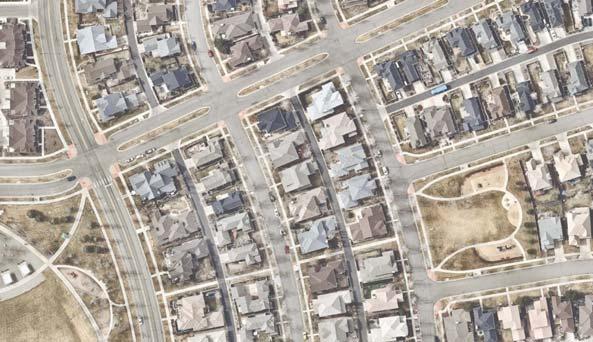
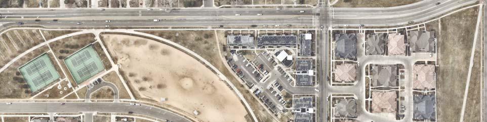
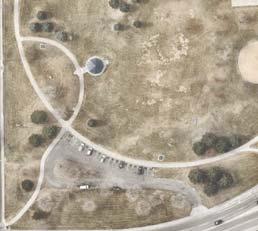
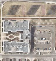
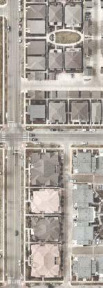
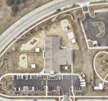
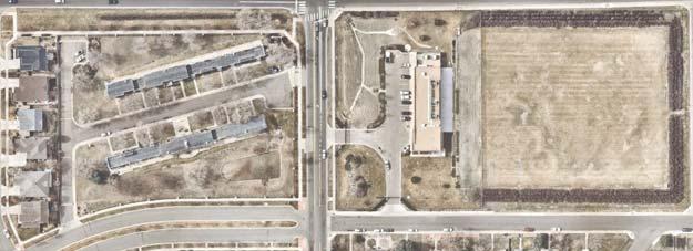
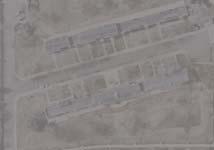
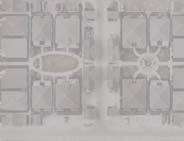
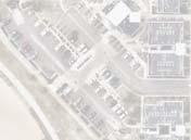
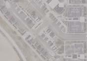
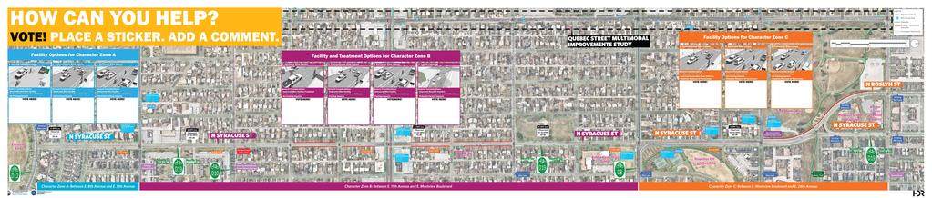
2 ABOUT THE PROJECT PLAED IMPROVEMETS FOR SYRACUSE STREET As part of Denver Moves: Bicycles, the City and County of Denver is developing new bicycle facilities along Syracuse Street (D9 Bicycle Route) between 8th Ave. and th Ave. We are evaluating the corridor to help identify low stress bicycle facility improvements that: COMPLEMET FUTURE IMPROVEMETS O QUEBEC ST. FROM TH AVE. TO TH AVE. COECT BICYCLE ETWORKS AD RTD BUS SERVICES IMPROVE ITERSECTIO SAFETY AD OPERATIOS FOR CYCLISTS, PEDESTRIAS, AD DRIVERS STAPLETO OFF LEASH DOG PARK ,000 FEET E TH PL 0 E TH AVE E RD AVE FRED THOMAS PARK S T A P L E T O ASHLEY ELEMETARY SCHOOL PRIMROSE SCHOOL AT STAPLETO / ACHOR CETER FOR BLID CHILDRE E TH AVE E 9TH AVE E 7TH AVE E TH AVE E COLFAX AVE SYRACUSE ST ZIO TEMPLE CHURCH MCICHOLS PARK E MOTVIEW BLVD QUEBEC STREET MULTIMODAL IMPROVEMETS STUDY E TH AVE D9 E TH AVE E TH AVE L O W R Y orth to th Ave. E TH AVE E 8TH AVE CRESCET PARK South to 8th Ave. C O L F A X E A S T QUEBEC ST


3 BICYCLE FACILITIES BIKEWAY OPTIOS FOR SYRACUSE STREET Shared Lane Markings Advisory Bike Lanes Conventional Bike Lanes Signs and pavement markings are the minimum treatments necessary visibly designate a roadway for both bicyclists and motorists remain on the designated route. Advisory bike lanes are bicycle priority areas delineated by dashed white lines cannot pass each other in both directions without crossing the advisory Bike lanes designate an exclusive space for bicyclists through the use of pavement markings and signage. The bike lane is located adjacent to motor vehicle travel lanes and is used in the same direction as motor TREATMET OPTIOS DESIG CRITERIA DESIG CRITERIA SHARED LAE MARKIGS OR SHARROWS Indicate a shared environment and sometimes direction and alerts CETER TWO-WAY TRAVEL LAE: - RECOMMEDED WIDTH Opposing vehicles to negotiate space. DESIRED BIKE LAE DIMESIOS: FEET WIDTH Minimum dimensions vary with curbface conditions: motor vehicle drivers to the potential presence of bicyclists. SUGGESTED BICYCLE AREA Provides positioning guidance for bicyclists outside of the door zone PROVIDES A WAYFIDIG ELEMET ALOG BIKE ROUTES ADVISORY BIKE LAE: -7 RECOMMEDED WIDTH Provide positioning guidance for bicyclists DASHED LAE LIES Permits encroachment as needed. foot minimum width when no curb and gutter is present. foot minimum width when adjacent to curb and gutter, or feet more than the gutter pan width if the gutter pan is wider than feet. foot minimum when adjacent to on-street parking, with consideration of a - foot parking-side buffer. eighborhood bikeway routes are sometimes circuitous, and clear route directions are important to provide. SIGAGE IDICATES TO BICYCLISTS THAT THEY ARE O A DESIGATED BIKEWAY Makes motorists aware of the bicycle route. HIGH UTILIZATIO PARKIG OR FREQUET CURB EXTESIOS Defines the edge of the travelway. PEOPLE DRIVIG YIELD TO BICYCLISTS Drivers must pass with care. O COTIUOUS CETERLIE Promotes safer vehicle passing maneuvers by giving bicyclists more clearance. REDUCE CAR DOOR COFLICTS Separation between bike lane striping and parking boundary reduces risks. BIKE LAE SIGAGE AD MARKIGS Bike lane signage may be located at the beginning and end bike of a lane. Symbol markings are used to define the bike lane and designate that portion of the street for preferential use by bicyclists, and shall be placed outside of the motor vehicle tread path at the far side beyond intersections, driveways, and merging areas in order to minimize wear. ADVISORY BIKE LAES Hanover, H TH STREET COVETIOAL BIKE LAE DASHED LIES AT BUS STOPS AD SIGALIZED ITERSECTIOS Alert cyclists to potential conflicts with transit and turning vehicles at designated stops and intersections.


 0 ft - 0 ft Typical")


4 BICYCLE FACILITIES BIKEWAY OPTIOS FOR SYRACUSE STREET Buffered Bike Lanes Protected Bike Lanes Buffered bike lanes are conventional bicycle lanes paired with a designated horizontal buffer space VHSDUDWLQJ WKH ELF\FOH ODQH IURP the adjacent motor vehicle travel lane and/or parking lane. Protected bicycle lanes are physically separated bike lanes that allow bicycle movement along the street. Separation for protected bicycle lanes is SURYLGHG WKURXJK SK\VLFDO EDUULHUV EHWZHHQ WKH ELH ODQH DQG WKH YHKLFXODU WUDYHO ODQH 7KHVH EDUULHUV FDQ LQFOXGH EROODUGV SODQWHU VWULSV UDLVHG FXUEV or on-street parking lanes. Protected bike lanes may use a variety of vertical elements to physically separate the bikeway from adjacent travel ODQHV %DUULHUV PD\ EH UREXVW FRQVWUXFWHG HOHPHQWV VXFK DV FXUEV RU PD\ EH PRUH LQWHULP LQ QDWXUH VXFK DV ÁH[LEOH GHOLQHDWRU SRVWV Delineator Posts/Bollards Parking Concrete Barrier or Raised Median in Typical Curb Height Continuous (Can allow drainage gaps) 0 ft - 0 ft Typical Spacing Planting Strips (optional) Continuous Spacing ft Typical Minimum ft Preferred in Preferred Minimum Planters Raised Lane in - in Height Typical Maintain consistent space between planters ft Preferred Minimum ft Typical Source: FHWA Separated Bike Lane Planning and Design Guide. 0. DESIG CRITERIA DESIG CRITERIA DESIG CRITERIA BIKE TRAVEL AREA DIMESIOS: FEET MIIMUM WIDTH BUFFER DIMESIOS: FEET WIDTH PREFERRED TRAVEL LAE BUFFER PARKIG SIDE BUFFER CHAMPA STREET BUFFERED BIKE LAE BIKE LAE SIGS Optional features such as signage may be located at the beginning and end of a marked bike lane. TH STREET OE-WAY PROTECTED BIKE LAE Travel lane buffer () and parking side buffer () can be combined. BICYCLE LAE SYMBOL MARKIGS ITEGRATE LADSCAPIG AD STORMWATER MAAGEMET The presences of landscaping in medians, planters and safety islands increases comfort for users and enhances the streetscape environment. BUFFER DIMESIOS:. FEET MIIMUM WIDTH COSIDER MAITEACE EEDS In constrained conditions, the barrier type may need to be removable to allow for regular maintenance. 7 minimum clear zone distance between curb and separation element to allow for maintenance. BARRIER PLACEMET Where possible, physical barriers such as bollards or removable curbs should be oriented towards the inside edge of the buffer to provide as much extra width as possible for bicycle use. WHE EXT TO PARKIG, ACCOMMODATE OPEIG DOORS Allow for feet of space in the buffer space to allow for opening doors and passenger unloading. The desired minimum width is feet and should be marked with solid white lines with interior diagonal cross hatching. For clarity at driveways or loading zones, consider a dotted line for the buffer boundary where cars are expected to cross. Separation between bike lane striping and parking to reduce risks of car door conflicts. Should be placed at the beginning and end of a protected bicycle lane and at periodic intervals along the facility based on engineering judgment to define the bike direction. Creates a lower-stress facility for bicycle riders on busier streets. PHYSICAL SEPARATIO Vertical separation treatments such as parking lanes, bollards, movable planters or raised curbs may be utilized. Buffer should be marked with solid white lines with interior diagonal cross hatching. For clarity at driveways or minor street crossings, consider a dotted line for the buffer boundary where cars are expected to cross. In constrained conditions, the minimum width for a buffer is foot 8 inches. MAXIMIZE EFFECTIVE OPERATIG SPACE Place curbs or delineator posts as far from the through bikeway space as practicable. Allow for adequate shy distance from vertical elements to maximize useful space. In areas with high bicycle volumes or uphill sections to facilitate safe passing behavior, the minimum desired width is 7 feet. Where bicyclist volumes are high, bicycle speed differentials are significant, or where side-by-side riding is desired. Preferred bicycle travel area dimensions is 7 feet wide. -WAY PROTECTED LAE DIMESIOS: FEET MIIMUM WIDTH IDIAAPOLIS CULTURAL TRAIL PROTECTED BIKE LAE Indianapolis, I


5 SPOT TREATMETS OTHER ELEMET OPTIOS FOR SYRACUSE STREET 7 Bike Box 8 Intersection Crossing Markings restrict certain movements for motorized travel to discourage the use of neighborhood bikeway corridors for through travel by automobiles by the route. Lower vehicle volumes increase bicyclists comfort and reduce signalized intersection that provides bicyclists with a safe and visible space phase. Motor vehicles must queue behind the white stop line at the rear of the bike box. Bike boxes requires restricting right turn on red vehicle movements. Bicycle pavement markings through intersections guide bicyclists on a safe and direct path through the intersection and provide a clear boundary between the paths of through bicyclists and vehicles in the adjacent lane. TYPE MARKIGS TYPE MARKIGS TREATMET OPTIOS MEDIA ISLAD Creates pinchpoint for traffic in the center of the roadway and offers shorter crossing distances for pedestrians when used in tandem with a marked crossing. CHICAE Slows drivers by requiring vehicles to shift laterally through narrowed lanes and which avoids uninterrupted sightlines. PICHPOIT/CHOKER/CURB EXTESIO Restrict motorists from operating at high speeds on local streets by visually narrowing the roadway. EIGHBORHOOD TRAFFIC CIRCLE Reduces speed of traffic at intersections by requiring motorists to move cautiously through conflict points. DESIG CRITERIA BIKE BOX A box formed by transverse lines to hold queuing bicyclists, typically 0- feet deep from the back of the crosswalk to the motor vehicle stop bar. Use of green colored pavement is optional for enhanced awareness. STOP LIES Used to indicate the point behind which motor vehicles are required to stop at traffic signals. PAVEMET MARKIGS Centered in the bike box to designate the space for bikes only. STOP HERE O RED SIG (MUTCD R0-) Used to reinforce observance of stop line for vehicles and should be postmounted at the stop line to reinforce observance for motorists. In addition, a o Turn on Red (MUTCD R0-) shall be installed overhead on a signal pole to prevent vehicles from entering the bike box. DESIG CRITERIA CROSSIG PAVEMET MARKIGS Used to designate bicycle crossing space at intersections. CROSSIG LAE STRIPE DIMESIOS: FEET TYPICAL Should match width and positioning of the leading bike lane. DASHED LIE SPACIG Consists of inch, foot long dashed white lines with - foot gaps from the center of the dashed line. Distributing markings across travel lanes to avoid vehicular tire paths will result in reduced wear and maintenance. STREET TREES arrow a driver s visual field and creates a consistent rhythm and canopy along the street, which provides a unified character and facilitates place recognition. IGRESS LAE (OPTIOAL) Used to provide access to the box and define the bicycle space,-0 feet back of the stop bar. EIGHBORHOOD TRAFFIC CIRCLE Madison, Wisconsin SHARROW SYMBOL Shared lane markings identify the route as a neighborhood bikeway, can guide users through jogs, and provide lane position guidance for bicyclists. BIKE BOX OPTIOAL SIG (MUTCD MODIFIED R0-) Used to remind right turning motorists to yield the right-of-way to pedestrians and bicyclists. TH STREET ITERSECTIO MARKIGS


,")


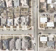

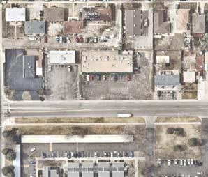
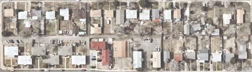


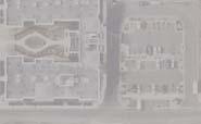


6 EXISTIG PEDESTRIA FACILITIES ACCESSIBILITY, SAFETY AD COMFORT ISSUES When evaluating pedestrian facilities, various elements should be considered including sidewalk condition and GLPHQVLRQV LQWHUVHFWLRQ DFFHVVLELOLW\ DQG WKH QXPEHU RI SRWHQWLDO FRQÁLFWV SRLQWV DVVRFLDWHG ZLWK GULYHZD\V and curbs cuts. A Missing and arrow walks Missing walks: Between th Ave. and Colfax Ave. (East side), Intermittent between Colfax Ave. and 7th Ave., Roslyn St. between th Ave. and th Ave. (West side), Syracuse St. between th Ave. and rd Ave. (West side) C Driveways and Curb Cuts B Accessibility In general, most intersections do not appear to be functionally accessible lacking Americans with Disabilities Act (ADA) curb ramps, detectable warning tiles and/or has inaccessible slopes. These include th Ave., th Ave., th Ave. and 7th Ave. arrow walks: Between th Ave. and th Ave. Due to commercial and residential accesses, there are a high number of driveways/curb cuts between th Ave. and th Ave. (West side), th Ave. and th Ave. (West ), th Ave. and Colfax Ave. (East side) Colfax Ave. and th Ave., 9th Ave. and Montview Blvd. (West side), and between Montview Blvd. and nd Ave. (West side) Multiple Driveways Inaccessible Corner QUEBEC STREET MULTIMODAL IMPROVEMETS STUDY 800 Character Zone C: Between E. Montview Boulevard and E. th Avenue AV Character Zone B: Between E. th Avenue and E. Montview Boulevard E TH AVE E MOTVIEW BLVD E 7TH AVE E TH AVE E TH AVE E TH AVE E TH AVE SPRUCE ST E TH Character Zone A: Between E. 8th Avenue and E. th Avenue SPRUCE ST Stapleton Off Leash Dog Park TH PL 00 Ashley Elementary School E ST AVE 00 PRIVATE RD E TH AVE E 8TH PL E 8TH AVE E 9TH AVE SYRACUSE CT 00 SYRACUSE ST E TH AVE AVE feet 0 Zion Temple Church Anchor Center For Blind Children SYRACUSE ST SYRACUSE ST SYRACUSE ST 0 Primrose School at Stapleton Mcichols (William H) Park SYRACUSE ST Crescent Park Fred Thomas Park ROSEMARY ST ROSEMARY ST ROSEMARY ST ROSLY ST E RD AVE ROSEMARY ST ROSEMARY ST E D AVE E 9TH E PL H AV E 8TH E 8T E COLFAX AVE A - Missing and/or narrow sidewalks CT SLY RO ROSLY ST E TH AVE OF TH ROSLY ST ROSLY CIR ROSLY ST ROSLY ST ICH ER C - Driveways/Curb Cuts E PL B - Intersection lacks ADA curb ramps, detectable warning tiles and/or has inaccessible slopes E ST AVE QUICE ST ST QUICE ST QUICE ST E BATAVIA PL E 8TH PL Missing and/or arrow walks E 9TH AVE E 9TH AVE E 0TH AVE E RICHTHOFE PL High umber of Driveways/Curb Cuts LY OS R View looking south towards E. th Ave. of several driveways that create an unsafe and uncomfortable pedestrian environment E TH AVE E 0TH AVE Inaccessible Intersection View of an inaccessible intersection at the southwest corner of E. th Ave. and Syracuse St. E TH AVE Lack of sidewalks between Colfax Ave. and E. th Ave. E TH AVE Missing walk SYRACUSE CT SPRUCE ST
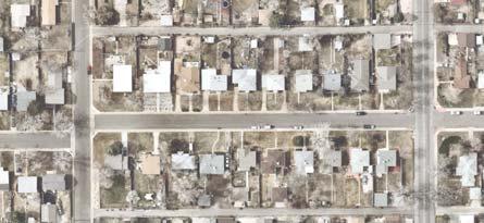
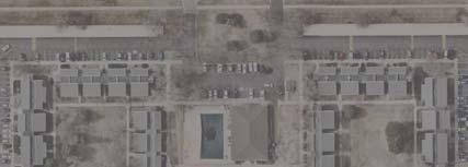
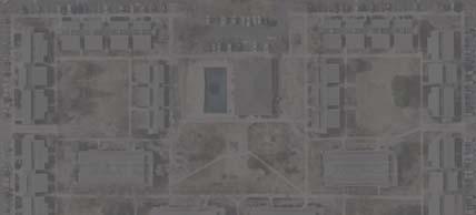
7 EXISTIG PARKIG UTILIZATIO ALOG SYRACUSE STREET Zone A 8th Ave. to th Ave. Zone B th Ave. to Montview Blvd. Zone C Montview Blvd. to th Ave. During the weekday early morning, midday and late evening, and on Sunday during the late morning, the maximum parking utilization in Character Zone A was. The maximum parking utilization observed on the west side of the street was % during the weekday early morning/late evening and on the east side the street during weekday early morning/late evening. o major parking restrictions exist. During the weekday early morning, midday and late evening, and on Sunday during the late morning, the maximum parking utilization in Character Zone B was %. The maximum parking utilization observed on the west side of the street was % during Sunday late morning and % on the east side of the street during Sunday late morning. Both locations are between Colfax Ave. and 7th Avenue near Zion Temple Church. During the weekday early morning, midday and late evening, and on Sunday during the late morning, the maximum parking utilization in Character Zone C was. The maximum parking utilization observed on the west side of the street was % during Sunday late morning and on the east side of the street during the weekday early morning/late evening. o major parking restrictions exist.. Weekday Early Morning/ Late Evening* *Represents the greatest utilization of both time periods. Weekday Midday. Sunday Late Morning Crescent Park Crescent Park Crescent Park 8th Avenue 8th Avenue 8th Avenue West East West 8th Place 8th Place % % 8% % 9th Avenue 9th Avenue % th Avenue th Avenue 8% Parking is restricted on the west side of the street between 7th Ave. and Montview Blvd. and on the east side between 9th Ave. and Montview Blvd. There is a weekday passenger loading zone (7am- pm) on the east side in front of Ashley Elementary School. th Avenue th Avenue % 8% 8% % % East West East 8th Place % % 8% 8% 9th Avenue th Avenue th Avenue th Avenue th Avenue % 8% th Avenue th Avenue % Colfax Avenue Colfax Avenue Syracuse Street % % % % 8% 8% % th Avenue % th Avenue % Colfax Avenue th Avenue th Avenue % % Syracuse Street % % th Avenue Zion Temple Church Zion Temple Church Syracuse Street Character Zone A: 8th Ave - th Ave Character Zone B: th Ave - Montview Blvd. Character Zone C: Montview Blvd. - th Ave 7th Avenue 7th Avenue Mcichols (William H) Park O PARKIG % O PARKIG 8% 8% 8% Mcichols (William H) Park O PARKIG 7th Avenue 9th Avenue 9th Avenue Montview Boulevard Montview Boulevard % % % % 9% O PARKIG % % % O PARKIG % % 9th Avenue Montview Boulevard nd Avenue nd Avenue nd Avenue rd Avenue rd Avenue rd Avenue th Avenue th Avenue th Avenue th Avenue % th Avenue th Avenue Roslyn Street % Roslyn Street % % Roslyn Street % % O PARKIG % % 8% % Zion Temple Church Mcichols (William H) Park Ashley Elementary School Ashley Elementary School Ashley Elementary School Greenway Park Greenway Park Greenway Park Thomas (Fred ) Park Thomas (Fred ) Park Thomas (Fred ) Park % % th Avenue th Avenue th Avenue % Primrose School at Stapleton & Anchor Center for Blind Children Primrose School at Stapleton & Anchor Center for Blind Children Primrose School at Stapleton & Anchor Center for Blind Children % of Parking Utilized* - - % - % Parking Restricted Greatest Utilization *Parking utilization was recorded during the week of September, 0
8
Cycle Track Design Best Practices Cycle Track Sections
 Design Best Practices Sections It is along street segments where the separation and protection methods of cycle tracks offer more comfort than conventional bicycle lanes, and are more attractive to a wide
Broad Street Bicycle Boulevard Design Guidelines
 Broad Street Bicycle Boulevard Design Guidelines Building from the strategies introduced in the 2013 Bicycle Transportation Plan and community input received thus far, City Transportation Staff have identified
Active Transportation Facility Glossary
 Active Transportation Facility Glossary This document defines different active transportation facilities and suggests appropriate corridor types. Click on a facility type to jump to its definition. Bike
Off-road Trails. Guidance
 Off-road Trails Off-road trails are shared use paths located on an independent alignment that provide two-way travel for people walking, bicycling, and other non-motorized users. Trails specifically along
DRAFT Montgomery County Bicycle Master Plan Design Toolkit
 DRAFT Montgomery County Bicycle Master Plan Design Toolkit Fall 2016 Sidepaths Sidepaths are shared use paths located parallel to and within the road right-of-way providing twoway travel for walking, bicycling,
Appendix C. TRAFFIC CALMING PROGRAM TOOLBOX
 Appendix C. TRAFFIC CALMING PROGRAM TOOLBOX PHASE I...2 Do Not Enter Sign...3 One-Way Sign...4 Turn Prohibition...5 Pavement Markings...6 Speed Monitoring Trailer...7 Neighborhood Speed Watch...8 Police
Bicycle Facilities Planning
 Bicycle Facilities Planning Overview Types of Cyclists Purpose for Riding Types of Facilities Bike Lanes Bicycle Boulevards Cycle Tracks Intersections Signals Signing and Marking Discussion Types of Bicyclists
REGIONAL BICYCLE AND PEDESTRIAN DESIGN GUIDELINES
 REGIONAL BICYCLE AND PEDESTRIAN DESIGN GUIDELINES November 16, 2011 Deb Humphreys North Central Texas Council of Governments Bicycle and Pedestrian Advisory Committee Snapshot of the Guide 1. Introduction
Southside Pilot Proposal
 To improve bicycle access and mobility to UC Berkeley, Downtown Berkeley, and the Southside area, a pilot project could include a two-way parking-protected cycle track. Turn pockets and island bus stops
Appendix 3 Roadway and Bike/Ped Design Standards
 Appendix 3 Roadway and Bike/Ped Design Standards OTO Transportation Plan 2040 4/20/2017 Page A3-1 Adopted Standards The adopted OTO Design Standards and Major Thoroughfare Plan are contained herein.
Designing On Road Bikeways
 Module B Learning Outcomes: Describe features of on road bikeways Select design criteria for on road bikeways in various contexts Bicycle Characteristics Height Handlebar 36 44 in Eye 60 in Operating 100
CURBSIDE ACTIVITY DESIGN
 5 CURBSIDE ACTIVITY DESIGN This chapter provides design guidance for separated bike lanes adjacent to curbside activities including parking, loading and bus stops. Typical configurations are presented
G AT E WAY PLAN. Community BRIEFING KIT GATEWAY BIKE
 G AT E WAY PLAN GATEWAY BIKE Community BRIEFING KIT PLAN August 2016 TABLE OF CONTENTS INTRODUCTION... 1 THE BENEFITS OF A BIKEABLE COMMUNITY... 2 ECONOMY...2 SAFETY...3 HEALTH...3 HOUSEHOLD SPENDING...3
Watertown Complete Streets Prioritization Plan. Public Meeting #1 December 14, 2017
 Watertown Complete Streets Prioritization Plan Public Meeting #1 December 14, 2017 Goals for Public Meeting Overview of MassDOT Complete Streets Funding Program Educate the community on Complete Streets
Color your stress away
 Color your stress away Learn about the Bicycle Master Plan s comfortable, low-stress bicycling network in Montgomery County. Unwind as you color the bicycling scenes. Check out montgomeryplanning.org/bikeplan
Guidance. ATTACHMENT F: Draft Additional Pages for Bicycle Facility Design Toolkit Separated Bike Lanes: Two-Way to One-Way Transitions
 ATTACHMENT F: Draft Additional Pages for Bicycle Facility Design Toolkit Separated Bike Lanes: Two-Way to One-Way Transitions This treatment provides a transition from two-way separated bike lanes to one-way
5 CIRCULATION AND STREET DESIGN
 5 CIRCULATION AND STREET DESIGN This chapter describes circulation and streetscape improvements proposed for the Northwest Chico Specific Plan Area. It includes detailed design specifications for existing
El Camino Real Specific Plan. TAC/CAC Meeting #2 Aug 1, 2018
 El Camino Real Specific Plan TAC/CAC Meeting #2 Aug 1, 2018 Land Use Alternatives Goals and Tradeoffs Parks & open space Housing Retail & services Civic spaces Parking Community gathering spaces 3 Alternatives
Appendices. Appendix A: Design Guidelines
 Appendix A: Design Guidelines This appendix is intended to assist in the selection and design of bicycle facilities. The following pages pull together best practices by facility type from public agencies
DRAFT FOR DISCUSSION PURPOSED ONLY, 10/26/13 MOBILITY PLAN UPDATE DESIGN TOOLBOX
 DRAFT FOR DISCUSSION PURPOSED ONLY, 10/26/13 MOBILITY PLAN UPDATE DESIGN TOOLBOX Tool #1: Bike Lane Portion of the roadway designated for preferential use by bicyclists. One-way facilities that typically
What Is a Complete Street?
 Session 5 Charleen Zimmer, AICP, Zan Associates May 5-7, 2010 What Is a Complete Street? May 2010 5-1 Not a Complete Street More of a Complete Street May 2010 5-2 Benefits of Complete Streets Safety for
On-Street Bicycle Facilities
 On-Street Bicycle Facilities A. General 12B-3 Design Manual Chapter 12 - Sidewalks and Bicycle Facilities 12B - Bicycle Facilities Cyclists have similar access and mobility needs as other transportation
STEERING COMMITTEE MEETING June 17, Streetscape Overview Burlington Comprehensive Master Plan
 STEERING COMMITTEE MEETING June 17, 2015 Streetscape Overview Burlington Comprehensive Master Plan 1 Introduction Slide This slide show was presented to the Burlington Steering Committee on June 17, 2015
Agenda. Overview PRINCE GEORGE S PLAZA METRO AREA PEDESTRIAN PLAN
 PRINCE GEORGE S PLAZA METRO AREA PEDESTRIAN PLAN May 28, 2008 Agenda Welcome and introductions Project overview and issue identification Planning context and strengths Design challenges and initial recommendations
Alternative Traffic Calming Methods
 Alternative Traffic Calming Methods In-street Pedestrian Crossing Sign Cost: approximately $300 per sign not including the installation cost Advantages of in-street pedestrian crossing signs 1. Typically
Small Town & Rural Multimodal Networks
 Small Town & Rural Multimodal Networks Fred Young, PLA Andrea Clinkscales, AICP, PMP Alta Planning + Design Funding Partners Project Team Existing Design Guidance AASHTO Flexibility Guide 2004 AASHTO Bike
NORTH DOWNTOWN N EAST WEST
 ORTH DOWTOW CHURCH STREET ALTERATE o. 1 BIKE LAES, O-STREET PARKIG, SIDEWALK AD MULTI-USE PATH This alternate incorporates a 5-foot sidewalk along the eastern side of Church Street, a 10-foot Multi-Use
C/CAG. Sunnybrae Elementary School Walking and Bicycling Audit. San Mateo-Foster City School District JUNE 2013
 Sunnybrae Elementary School Walking and Bicycling Audit JUNE 2013 San Mateo-Foster City School District C/CAG City/County Association of Governments of San Mateo County SUNNYBRAE ELEMENTARY SCHOOL WALKING
A Insert design-related public comment here.
 Design Guidelines A Insert design-related public comment here. - Public Comment, 2016 This regional plan focuses on connecting regional nodes, such as Wilmington, NC (Gary Shell Cross-City Trail shown
On Road Bikeways Part 1: Bicycle Lane Design
 On Road Bikeways Part 1: Bicycle Lane Design Presentation by: Nick Jackson Bill Schultheiss, P.E. September 04, 2012 FOLLOW THE CONVERSATION ON TWITTER Toole Design Group is live tweeting this webinar
City of Seattle Edward B. Murray, Mayor
 City of Seattle Edward B. Murray, Mayor Department of Transportation Scott Kubly, Director Eastlake Community Council 117 E Louisa St. #1 Seattle, WA 98102-3278 January 28, 2016 RE: Roosevelt to Downtown
City of Vallejo Traffic Calming Toolbox
 City of Vallejo Traffic Calming Toolbox June 1, 2013 Final Table of Contents Introduction... 1 Non-Physical Devices... 3 High-Visibility Crosswalk... 3 In Pavement Lighted Crosswalk... 4 Rapid Flashing
Caltrans Sloat Boulevard Pedestrian Safety Project Response to Community Questions, Comments & Concerns
 Caltrans Sloat Boulevard Pedestrian Safety Project Response to Community Questions, Comments & Concerns Revised: May 10, 2016 The California Department of Transportation (Caltrans) is planning various
Bicycle Boulevards and Neighborhood Greenways
 Bicycle Boulevards and Neighborhood Greenways Traffic Safety is Improving for Everyone 90 80 70 60 50 40 30 20 10 0 PORTLAND: TOTAL TRAFFIC FATALITIES 1986-2008 1986 1987 1988 1989 1990 1991 1992 1993
Central Avenue Bikeway Traffic and Safety Impact Assessment
 FEBRUARY 2018 Lead Agency: San Diego Association of Governments (SANDAG) 401 B Street, Suite 800 San Diego, CA 92101 Contact: Chris Carterette, AICP, Project Manager 619.699.7319 chris.carterette@sandag.org
LANCASTER CITY BICYCLE NETWORK
 LANCASTER CITY BICYCLE NETWORK Downtown Merchants Meeting Wednesday, July 19, 2017 http://www.lancasteratp. DOWNTOWN WALKABILITY ANALYSIS What changes can be made, in the least amount of time, and for
INTRODUCTION. Intersections Treatments
 Table of Contents Introduction Bikeway Facility Types Off-Street Trails Stream Valley Park Trails Sidepaths Separated Bike Lanes Buffered Bike Lanes Conventional Bike Lanes Advisory Bike Lanes Bikeable
Complete Streets Design Considerations. Second Street Corridor Complete Streets Workshop and Assessment Manchester, NH April 26, 2013
 Complete Streets Design Considerations Second Street Corridor Complete Streets Workshop and Assessment Manchester, NH April 26, 2013 2 nd Street Existing Information Average Annual Daily Traffic Volumes
Duwamish Way-finding and CTR Report
 V. North Tukwila When the North Tukwila Manufacturing and Industrial Center was designated in 1992 as part of the region s land use and transportation plan, the plan called for the area to set a light-rail
OBJECTIVE: Improve safety by designing all bicycle facilities to the latest AASHTO bicycle guidelines and 2009 MUTCD Standards.
 DESIGN AND APPLICATION OF GUIDELINES AND STANDARDS The Citizen Advisory and Technical Advisory Committees identified improving safety by providing consistent bicycle facilities throughout the region as
Task 4 Wayfinding Elements, Placement and Technical Guidance 4.1 Wayfinding Elements
 1836 Blake Street Denver, CO 80202 720.524.7831 ww.altaplanning.com MEMO 3 Task 4 Wayfinding Elements, Placement and Technical Guidance 4.1 Wayfinding Elements Based on field reconnaissance, best practices
PRINCE GEORGE S PLAZA METRO AREA PEDESTRIAN PLAN
 PRINCE GEORGE S PLAZA METRO AREA PEDESTRIAN PLAN May 28, 2008 Agenda Welcome and introductions Project overview and issue identification Planning context and strengths Design challenges and initial recommendations
DRAFT - CITY OF MEDFORD TRANSPORTATION SYSTEM PLAN Roadway Cross-Sections
 Roadway Cross-Sections Medford s roadway cross-section standards apply to new and reconstructed roads. The crosssections take into consideration roadway function and operational characteristics, including
CONCEPT ALTERNATIVE 1 (BICYCLE BOULEVARD ON BROAD WITH TRAFFIC DIVERSION)
") RAMOA FOOTHILL MEIECKE MILL 1" = 350' TRAFFIC DIVERTER MEIECKE BETO MURRAY SATA ROSA SERRAO MISSIO CETER WEST VEABLE MISSIO MISSIO ALMOD MOUTAI VIEW CETER LICOL CETER LICOL COCEPT ALTERATIVE 1 ( O WITH
RAMOA FOOTHILL MEIECKE MILL 1" = 350' TRAFFIC DIVERTER MEIECKE BETO MURRAY SATA ROSA SERRAO MISSIO CETER WEST VEABLE MISSIO MISSIO ALMOD MOUTAI VIEW CETER LICOL CETER LICOL COCEPT ALTERATIVE 1 ( O WITH
Chapter 4 TOOLBOX AND SAMPLE BIKE BOULEVARD LAYOUT
 Chapter 4 TOOLBOX AND SAMPLE BIKE BOULEVARD LAYOUT OVERVIEW This chapter describes a cohesive set of strategies to create a bicycle boulevard, namely to make streets safer and more efficient for bicycle
APPENDIX A: Complete Streets Checklist DRAFT NOVEMBER 2016
 APPENDIX A: Complete Streets Checklist DRAFT NOVEMBER 2016 Complete Streets Checklist MetroPlan Orlando s Complete Streets Checklist is an internal planning tool for staff to further implementation of
4.1 CONTEXT. The existing terrain and sight conditions will affect available sight lines and approach speeds of bicyclists and motorists.
 4 INTERSECTION DESIGN This chapter provides key principles that should be used to develop and evaluate design approaches and treatments that will result in intersections that support all ages and abilities
ARLINGTON COUNTY PAVEMENT MARKING SPECIFICATIONS
 DEPARTMENT OF ENVIRONMENTAL SERVICES ARLINGTON COUNTY PAVEMENT MARKING SPECIFICATIONS MAY 2017 Table of Contents 1. General... 2 2. Design Criteria... 3 3. Marking Plan Preparation... 4 Exhibits... 5 MK
5. RUNNINGWAY GUIDELINES
 5. RUNNINGWAY GUIDELINES These guidelines should be considered collectively when making runningway decisions. A runningway is the linear component of the transit system that forms the right-of-way reserved
General Design Factors
 Chapter 3: 3-1.0 Introduction General Design Factors Mn/DOT s goals include encouraging and accommodating safe bicycling. From a design perspective, these goals are achieved by first having an understanding
Public Information Centre
 WELCOME Public Information Centre Father Tobin Road Lougheed Middle School - Library Wednesday November 7, 2012 7:00 p.m.to 9:00 p.m. Please sign in Neighbourhood Traffic Calming Guide Background The City
Chapter 4 On-Road Bikeways
 Chapter 4: 4-1.0 Introduction On-Road Bikeways This chapter provides guidelines to help select and design safe on-road bikeways. On-road bikeways include bicycle lanes, shared lanes, shoulders, and wide
Designing Pedestrian Facilities for Accessibility. Module 3 Curb Ramps & Blended Transitions
 Module 3 & Other Purpose: Allow pedestrians to transition between the street and sidewalks, islands, etc. Typically installed at: Intersections (1 ramp at each end of each crosswalk) Mid-block crossings
FOCUS AREA 1 - Alberta Avenue Pocket Park 3 (121 Ave and 92 St)
") FOCUS AREA 1 - Alberta Avenue Pocket Park 3 (121 Ave and 92 St) New benches Plant evergreen trees Widen existing sidewalk from 1.5m to 1.8m Marked crosswalk 1.8m wide sidewalk Add pedestrian oriented lights
FOCUS AREA 1 - Alberta Avenue Pocket Park 3 (121 Ave and 92 St) New benches Plant evergreen trees Widen existing sidewalk from 1.5m to 1.8m Marked crosswalk 1.8m wide sidewalk Add pedestrian oriented lights
Bowman-Melton Associates, Inc. june 2011
 2011 dallas bike plan ADDENDUM Bowman-Melton Associates, Inc. Complete Streets Initiative Design and policy guidance june 2011 2 2011 Dallas Bike Plan Complete Streets Initiative Design and Policy Guidance
INTERSECTION DESIGN TREATMENTS
 Designing for Bicyclist Safety INTERSECTION DESIGN TREATMENTS LEARNING OUTCOMES Understand intersection design options and features Select appropriate design feature for a bikeway in a given context C1
Orange Center Elementary School
 Drag and drop pic and stretch/crop to the limits of the blue rectangle (delete this text box) Orange Center Elementary School Drag and drop pic and stretch/crop to the limits of the blue rectangle (delete
Safe Routes to School: Munroe Elementary Walk Audit Report. Image: Drexel, Barrell & Co.
 Safe Routes to School: Munroe Elementary Walk Audit Report Image: Drexel, Barrell & Co. April 12, 2016 OVERVIEW As part of the 2014/2015 Denver Safe Routes to School (SRTS) Program, WalkDenver coordinated
Who is Toole Design Group?
 2018 AASHTO Bike Guide Status Update NCHRP 15 60 Amalia Leighton Cody, PE, AICP & Kenneth Loen, PE Washington APWA October 4, 2018 Who is Toole Design Group? TDG is a full service engineering, planning
e. 173rd/AVALON bicycle boulevard Shaker Heights Review Meeting - May 9, 2013
 e. 173rd/AVALON bicycle boulevard Shaker Heights Review Meeting - May 9, 2013 Transforming a neighborhood barrier into Greater Cleveland s First Bicycle Boulevard Project Schedule Phase 1 Site Visit (Documentation
RIVERSIDE DRIVE: 21st to 41st
 RIVERSIDE DRIVE: 21st to 41st Traffic Calming, Parking Lane, and Bike Lane Traffic Calming Options Traffic Calming Design Alternatives and Recommendations by Road Section Parking Lane & Bike Lane Guidance
Mission-Geneva Transportation Study Community Workshop 2 July 8, 2006
 Community Workshop 2 July 8, 2006 Small Group Workbook 1 Basic Improvements on Mission Street Streetscape. Pedestrian-scale lighting; landscaping; community art on utility boxes; more (possibly unique)
Transportation Planning Division
 Transportation Planning Division Presentation Outline Study Tasks Recap of Previous Meetings Data Collected Focus Areas within Study Limits Design Principles Tool Box Recommended Concepts Schedule Moving
CHAPTER 16 PEDESTRIAN FACILITIES DESIGN AND TECHNICAL CRITERIA TABLE OF CONTENTS
 CHAPTER 16 PEDESTRIAN FACILITIES DESIGN AND TECHNICAL CRITERIA TABLE OF CONTENTS Section Title Page 16.1 General... 16-1 16.1.1 AASHTO Reference... 16-1 16.1.2 ADA Requirements... 16-1 16.2 Sidewalks...
DRAFT. Scholls Ferry Road Conceptual Design Plan Technical Memorandum Multi-Modal Examples. Multnomah County 1600 SE 190th Avenue Portland, OR 97233
 Technical Memorandum Multi-Modal Examples Prepared for 1600 SE 190th Avenue Portland, OR 97233 December 2008 CITATION This project is partially funded by a grant from the Transportation and Growth Management
Multimodal Through Corridors and Placemaking Corridors
 68 Multimodal Through Corridors and Placemaking Corridors Corridors have different functions in a region. Some corridors are used to get smoothly and rapidly through a region or to get quickly to major
North Avenue Corridor Study
 North Avenue Corridor Study Advisory Committee Meeting #6 July 1, 2014 Agenda Concept Revisions based on Advisory Committee feedback Review of New Concept Scoring & Costs Concept Discussion/Questions Voting:
Omaha s Complete Streets Policy
 Omaha s Complete Streets Policy (Adopted August 2015) VISION To create great places and enhance our quality of life, the City of Omaha will provide safe, accessible streets for all users. Complete Streets
Memo. Introduction. Memphis STP Pedestrian Sidewalk Project
 Memo Memphis STP Pedestrian Sidewalk Project To: Kyle Wagenshutz, City of Memphis From: Matthew Berkow, Collin Chesston, and Anne Eshleman, Alta Planning + Design Date: June 2014 Re: Photo Inventory Introduction
Complete Streets Policy DAVID CRONIN, P.E., CITY ENGINEER
 Complete Streets Policy DAVID CRONIN, P.E., CITY ENGINEER Complete Streets City Commission adopted a Complete Streets policy in 2012 Complete Streets are road networks that are designed for all users:
Appendix C. City of Fort Collins Recommended Bicycle Design Guidelines. Appendix C: Recommended Bicycle Design Guidelines 1
 Appendix C City of Fort Collins Recommended Bicycle Design Guidelines Appendix C: Recommended Bicycle Design Guidelines 1 This appendix provides general design considerations for implementation of bicycle
City Snapshot September 27, 2018
 1 City Snapshot September 27, 2018 Respondent Introduction Thank you for providing data for the PlacesForBikes City Rating program! The information you provide will be used to understand the progress your
TRAFFIC CALMING GUIDE FOR TORONTO CITY OF TORONTO TRANSPORTATION SERVICES DIVISION
 TRAFFIC CALMING GUIDE FOR TORONTO CITY OF TORONTO TRANSPORTATION SERVICES DIVISION CITY OF TORONTO TRANSPORTATION SERVICES DIVISION 2016 TRAFFIC CALMING GUIDE FOR TORONTO TABLE OF CONTENTS Introduction
Figure 5-1 Complete Street Zones. Roadside. May include frontage, pedestrian throughway, furnishings and curbside areas.
 Design Guidelines 5 The design guidelines presented in this section provide descriptions related to the form and function of the four Complete Streets zones: roadside, parking, roadways and lanes, median,
ATTACHMENT NO. 11. RRLRT No. 2. Railroad / Light Rail Transit Technical Committee TECHNICAL COMMITTEE: Busway Grade Crossings STATUS/DATE OF ACTION
 ATTACHMENT NO. 11 RRLRT No. 2 TECHNICAL COMMITTEE: TOPIC: Railroad / Light Rail Transit Technical Committee Busway Grade Crossings STATUS/DATE OF ACTION RRLRT TC Draft: 06/23/2011 RRLRT TC Approval: 06/27/2014
Toole Design Group is live tweeting this webinar
 On Road Bikeways Part I1: Non-Bike Lane Design Presentation by: Bill Schultheiss, P.E. Tina Fink, P.E. September18, 2012 FOLLOW THE CONVERSATION ON TWITTER Toole Design Group is live tweeting this webinar
Rolling Out New Bike Facilities Within the North Bethesda & White Flint Area
 Rolling Out New Bike Facilities Within the North Bethesda & White Flint Area Rolling Out New Bike Facilities Within the North Bethesda & White Flint Area Agenda Designing for all Cyclists Background on
MARTIN LUTHER KING JR. WAY
 OCTOBER 2011 40 Vision and Goals The Martin Luther King, Jr. Way Illustrative Master Plan that follows has been developed through a process of community involvement. It expresses a long term vision for
Safe Streets. City of Lake Forest Park. March 21, 2017
 Safe Streets City of Lake Forest Park March 21, 2017 1 01 WELCOME 2 Agenda WELCOME WHAT IS THIS PROJECT? CONTEXT DRAFT CITYWIDE PROJECTS EXERCISE INTRODUCTION 3 02 WHAT IS THIS PROJECT? 4 WHAT IS THIS
CITY OF SARATOGA SPRINGS PEDESTRIAN CROSSING TOOLBOX
 CITY OF SARATOGA SPRINGS PEDESTRIAN CROSSING TOOLBOX This toolbox is to be used to guide pedestrian crossing improvements within the City of Saratoga Springs. Details for each crossing type are provided.
MEMORANDUM. Date: 9/13/2016. Citywide Crosswalk Policy
 MEMORANDUM Date: 9/13/2016 Re: Citywide Crosswalk Policy Foreword Through the s Circulation Element and Complete Streets Policy, it is the City s goal to promote walking trips and provide safe facilities
THE OFFICIAL GUIDE TO CYCLING SAFELY IN PHILADELPHIA
 B IKE NICE THE OFFICIAL GUIDE TO CYCLING SAFELY IN PHILADELPHIA A partnership of the City of Philadelphia and the Bicycle Coalition of Greater Philadelphia ABOUT VISION ZERO & BIKE NICE It s a great day
Appendix A. Knoxville TPO Greenway Signage Guidelines. Appendix A: Knoxville TPO Greenway Signage Guidelines Knox to Oak Ridge Greenway Master Plan
 Appendix A Knoxville TPO Greenway Signage Guidelines 75 Overview: Adequate signing and marking are essential on shared-use paths, especially to alert bicyclists to potential conflicts and to convey regulatory
CURB EXTENSIONS BULB OUTS DPS 201 NECKDOWNS
 CURB EXTENSIONS BULB OUTS DPS 201 NECKDOWNS WHY WHEN & WHERE When Limited Sight Distance Pedestrians & Vehicles Vehicles and Signs Want to put two curb ramps in Discourage High speed turning High number
Derby Street. Project Updates. Salem, Massachusetts
 Derby Street Project Updates Salem, Massachusetts September 13, 2017 Project Limits Derby Street Project Objectives 1. Improve complete streets elements on Derby Street 2. Improve sidewalks on finger streets
Report. Typical Sections. City of Middleton, WI
 Report Typical Sections City of Middleton, WI December 2006 Report for City of Middleton, Wisconsin Typical Sections repared by: Traffic Associates LLC and STRAND ASSOCIATES, INC. 910 West Wingra Drive
Completing the Street: Denning Drive
 Completing the Street: Denning Drive Public Workshop and Walking Audit Winter Park Civic Center May 12, 2016 Completing the Street What Makes This a Complete Street? Completing the Street Complete Streets
DISTRIBUTION: Electronic Recipients List TRANSMITTAL LETTER NO. (17-01) MINNESOTA DEPARTMENT OF TRANSPORTATION. MANUAL: Road Design English Manual
 MINNESOTA DEPARTMENT OF TRANSPORTATION. MANUAL: Road Design English Manual") DISTRIBUTION: Electronic Recipients List MINNESOTA DEPARTMENT OF TRANSPORTATION DEVELOPED BY: Design Standards Unit ISSUED BY: Office of Project Management and Technical Support TRANSMITTAL LETTER NO.
DISTRIBUTION: Electronic Recipients List MINNESOTA DEPARTMENT OF TRANSPORTATION DEVELOPED BY: Design Standards Unit ISSUED BY: Office of Project Management and Technical Support TRANSMITTAL LETTER NO.
WELCOME Public Information Centre
 WELCOME Public Information Centre Fernforest Drive Brampton Soccer Centre Community Room #2 Tuesday January 19, 2016 6:30 p.m.to 9:00 p.m. Please sign in Neighbourhood Traffic Calming Guide Background
MAG Town of Cave Creek Bike Study Task 6 Executive Summary and Regional Significance Report
 Page 1 MAG Town of Cave Creek Bike Study Task 6 Executive Summary and Regional Significance Report August 1, 2012 MAG Project #481 Page 2 Task 6 Executive Summary and Regional Significance Report Introduction
TRAFFIC CALMING TOOLBOX
 TRAFFIC CALMING TOOLBOX Traffic control devices are those official signs and striping placed in the public right-of-way and recognized by the public such as STOP signs, curve warning signs, centerline
CHAPTER 1 STANDARD PRACTICES
 CHAPTER 1 STANDARD PRACTICES OBJECTIVES 1) Functions and Limitations 2) Standardization of Application 3) Materials 4) Colors 5) Widths and Patterns of Longitudinal Pavement Marking Lines 6) General Principles
Meadow Woods Elementary School
 Drag and drop pic and stretch/crop to the limits of the blue rectangle (delete this text box) Meadow Woods Elementary School Drag and drop pic and stretch/crop to the limits of the blue rectangle (delete
Town of Windsor Pedestrian Crossing Guidelines
 Town of Windsor Pedestrian Crossing Guidelines Prepared for: Town of Windsor Engineering Department 301 Walnut Street Windsor, Colorado 80550 For More Information, please contact: Engineering Department
Aurora Urban Street Standards For Transit Oriented Developments and Urban Centers
 Aurora Urban Street Standards For Transit Oriented Developments and Urban Centers I. Purpose These standards will be applied to create a safe, comfortable, pleasant and pedestrian-friendly multi-modal
700 Multi-Modal Considerations
 700 Multi-Modal Considerations Table of Contents 701 Railroads... 7-1 701.1 Background... 7-1 701.2 Crossing At-Grade... 7-1 701.2.1 General... 7-1 701.2.2 Railroad Parallel to Highway... 7-1 701.3 Lateral
CONNECTIVITY PLAN. Adopted December 5, 2017 City of Virginia Beach
 CONNECTIVITY PLAN Adopted December 5, 2017 City of Virginia Beach CONTENTS 1.0 Background & Purpose... 2 2.0 Existing Inventory & Analysis... 3 ViBe District Existing Walking Conditions... 4 3.0 ViBe District
2014/2015 BIKE ROUTE PLAN 83 AVENUE PROTECTED BIKE LANE
 About the Project The City of Edmonton is planning a major bike route on the southside of Edmonton. The Strathcona Bike Route will connect the communities of Strathcona, Garneau and the University area,
Fulton Market Streetscape
 Fulton Market Streetscape Ogden Avenue to Halsted Street Public Meeting Recommended Improvements December 10th, 2014 Meeting Purpose and Goals Present Existing Conditions Community Input and Charrette
Observations and Ideas: Toomer s Corner Streetscape Improvements
 Observations and Ideas: Toomer s Corner Streetscape Improvements AUBURN DOWNTOWN MASTER PLAN planning downtown s future August 26, 2013 Observations: Vertical Clutter at Corners 6 3 7 5 9 2 8 4 1 Excess