bycycle ashlynne camuti
|
|
|
- Calvin Fleming
- 6 years ago
- Views:
Transcription


1 bycycle ashlynne camuti
2 PROBLEM STATEMENT + HYPOTHESIS Bikers need a way to forecast route conditions because unexpected conditions can lead to a stressful and delayed ride. We believe that by providing a simple pre-ride forecast for commuters, we will achieve greater route efficiency, skimming minutes off planning and ride time.
3 USER RESEARCH
4 TARGET AUDIENCE Urban commuter cyclists + bike enthusiasts
5 USER INTERVIEWS [4] interviews were conducted with individuals who bike frequently for commuting, exercise, and fun. Each person approaches biking uniquely but similarities can be drawn between them to discern primary motivations and pain points.
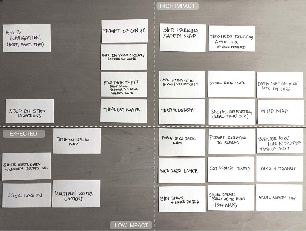
6 KEY GOALS + TAKEAWAYS USER GOALS TAKEAWAYS - Find efficient routes for commuting with minimal effort - Bike as means for quick transport to multiple destinations - Ride for leisure and discovery of new places - [pain point] Users have limited trust in bike infrastructure - [pain point] It s difficult to plan social activities around bikeability because of safety concerns - [pain point] concerns: theft, popped tires, drivers - Despite pain points, bikers are going to bike because it s efficient, economical, and enjoyable
![CAROLINE I just didn t have time to think about traffic this morning I was already late to my first meeting and the closed road made me even later [with frustration] GOALS + NEEDS PAIN POINTS Age: 32](/docs-images/72/67047088/images/7-0.jpg "Occupation: Industrial Designer Income: $80k Residence: San Francisco Education: College Grad Other Info: Works hard, plays hard, bikes hard - Commute efficiency - Rides to multiple destinations -")
7 CAROLINE I just didn t have time to think about traffic this morning I was already late to my first meeting and the closed road made me even later [with frustration] GOALS + NEEDS PAIN POINTS Age: 32 Occupation: Industrial Designer Income: $80k Residence: San Francisco Education: College Grad Other Info: Works hard, plays hard, bikes hard - Commute efficiency - Rides to multiple destinations - Needs to keep bike and all of its parts - Unpredictable infrastructure - Stress in biking vs no biking - Safety concerns

8 FRANKLIN My co-worker told me I can take my bike on the train and bike to school from there. Sweet! GOALS + NEEDS PAIN POINTS Age: 27 Occupation: High School Teacher Income: $45k Residence: San Francisco Education: Masters in Education Other Info: Weekend musician, daytime statistician - Bike as alternate/addition to transit commute - Rides socially - Rides for enjoyment - Weather - New route = more planning - Different route = unfamiliar territory


9 COMPETITIVE ANALYSIS GOOGLE MAPS WAZE GET THERE BY BIKE Point A to B directions for bike navigation with consideration to bike infrastructure and road type. Outsmarting traffic by collecting and sharing real-time information from drivers. Data sharing component allows users to alert other users of traffic, accidents, police activity, etc. App intends to help commuters get from A to B while providing information or iconography indicating elements that can make a ride bad.
10 USER FLOW, IA, FEATURES

11 PAPER PROTOTYPE
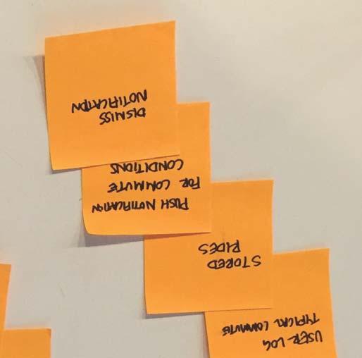
12 USER FLOW FLOWING THROUGH A DAY IN THE [BIKE] LIFE OF CAROLINE HOME wake up silence alarm check commute status + weather route congestion push prompt to open app select suggested alternative route view and absorb route [thought > action] [safe?] contemplate schedule and plan for concert after work open app enter venue address review theft v visual + id safe zones plan to ride + park 2 blocks from venue morning routine bike to work + avoid closures park bike in WORK \\ EOD WORK retrieve bike open app enter venue address map route check conditions bike to show park safely
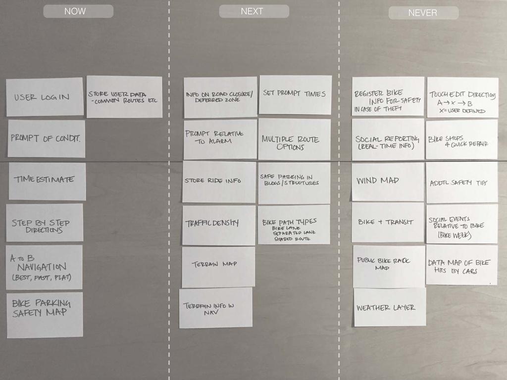
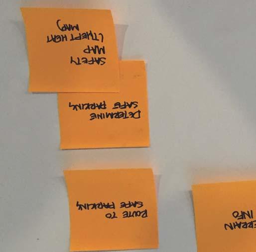
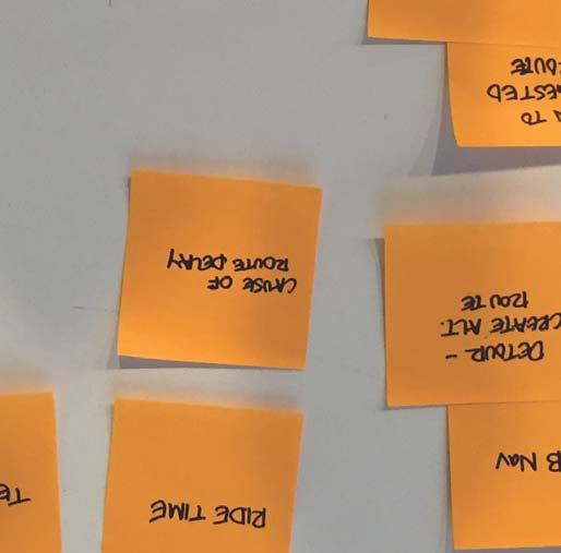
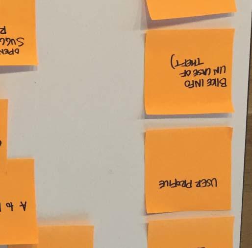
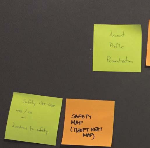
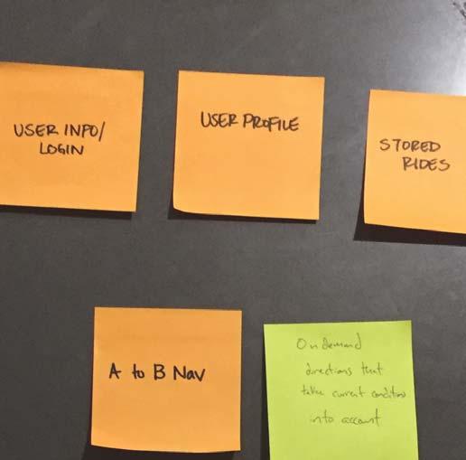
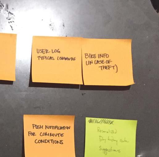
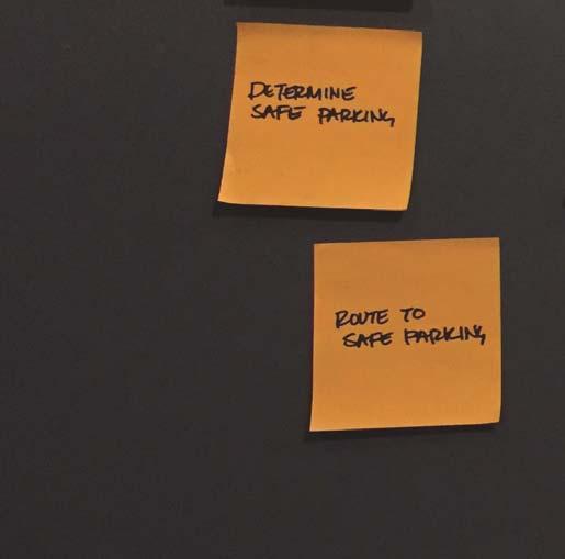
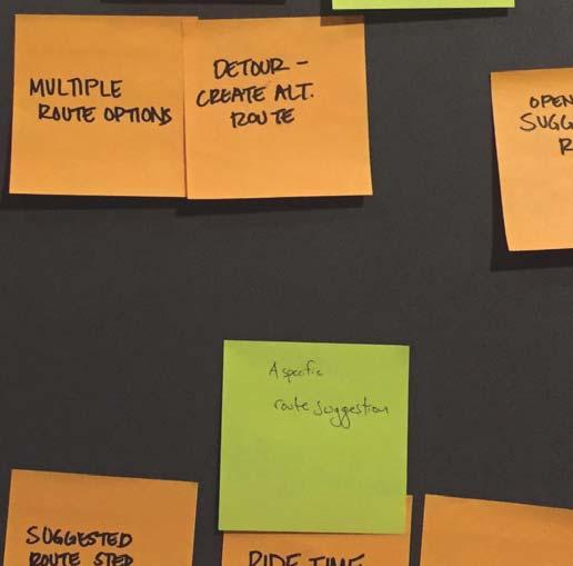
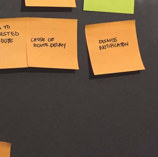
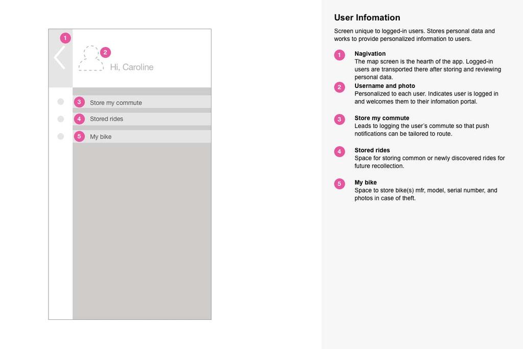
13 SITE MAP ONBOARDING USER INFO ROUTE FORECAST A TO B NAVIGATION STORE COMMUTE NORMAL VS ALT. ROUTE STEP BY STEP MAP WITH START/END TIME MULTIPLE OPTIONS PUSH NOTIFICATIONS CAUSE OF DELAY TERRAIN MAP STORED RIDES USER CREATED ROUTE MY BIKE THEFT HEAT MAP SERIAL NUMBER PARKING INFO PHOTOS
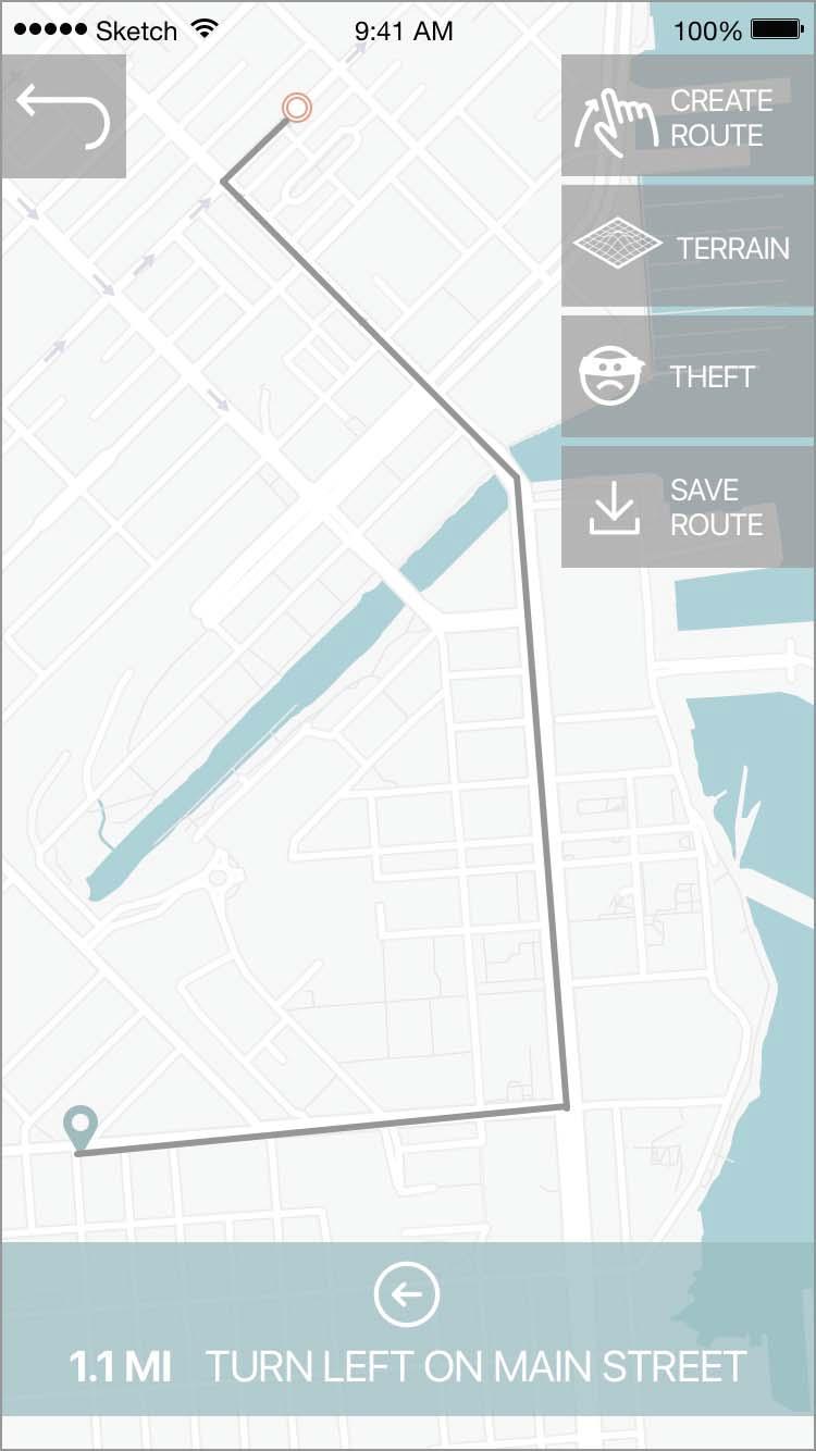
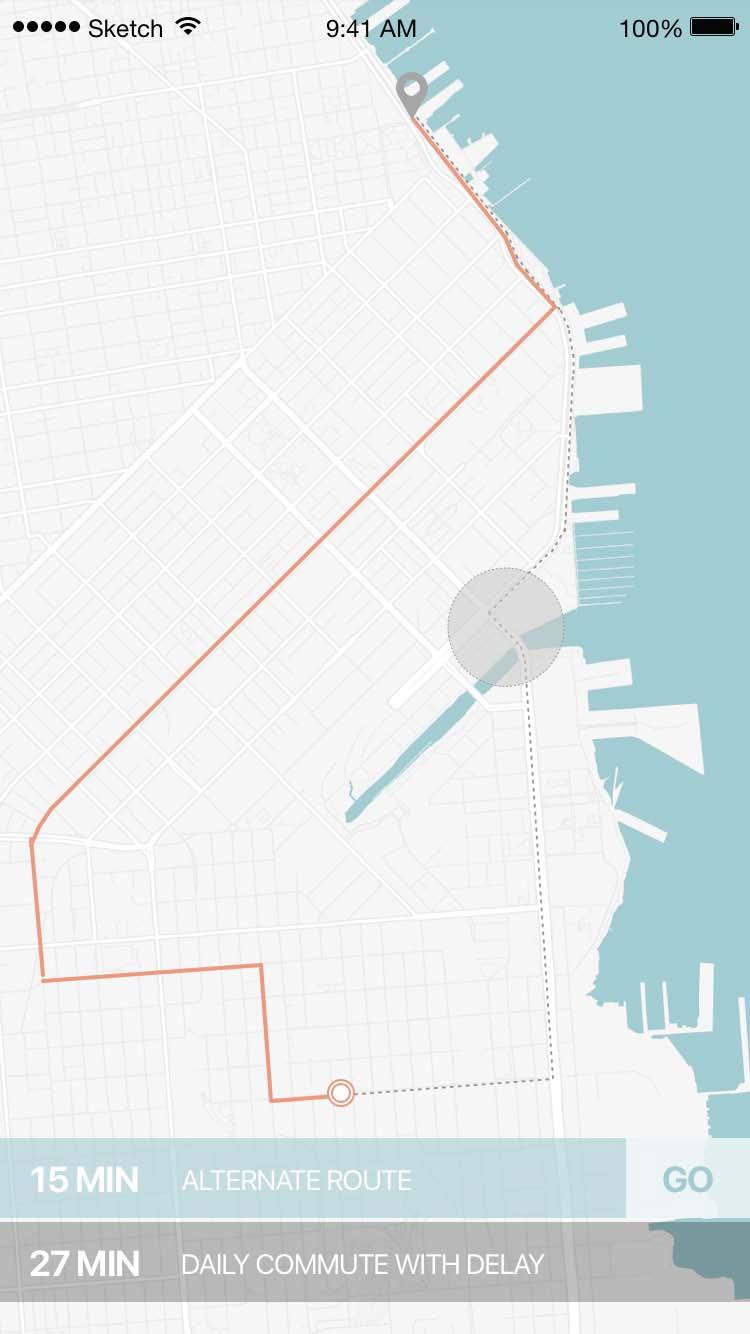
14 FEATURES FOR MVP ROUTE FORECASTING NAVIGATION THEFT MAPPING A prompt is featured before each commute. It appears to the user before they have to think about opening the app, making it harder to forget to check the route before, thus saving time before and during a ride. Two levels of navigation: A to B; A to B with user detours - where users are able to swipe an extension or reroute though an area that isn t on the direct to point B route. Tertiary feature which incorporates data from reported bike thefts in particular areas and creates a zoomable heat map so users can quickly glance at an area and assess safety relative to bike parking.

15 HI FI PROTOTYPE
16 CONSTRAINTS TIME User has limited time to absorb information before embarking on ride. More time spent looking at the app beforehand = less time available for riding. TECHNOLOGY Step by step directions are difficult to access while biking without creating a safety hazard or requiring use of additional accessories for the bike.
17 NEXT STEPS - Social network integration - Apple watch / wearable integration + direction interface - Real time traffic data reporting - Weather + wind map layer
18 APPENDIX


19 Competitive Analysis Google Maps Direct Strava Indirect Waze Indirect Get There By Bike Direct COMPETITIVE RESEARCH Look & Feel Clean, comfortable, clarity of information Web and app feel different. Basing this on the app.. Clean lines. Interesting light style on record screen and darker interfaces on all of the data organization and social screens. Whimsical and childish. Less of a line weight hierarchy when looking the map. Clean and simple upon initial log-in. Map (Google) with bike info looks cleaner and more connected than Google s bike maps. IA + Ease of Navigation Takes a minute to hop around the app and find things like terrain, satellite. Just updated to move these options to top bar instead of side bar in direction mode. Though two different approaches to navigation layout - in resting mode and in nav mode. Clear how user walks through navigation and directions with pin drops for each step as needed. Information is great - logs a lot of data and presents it in interesting ways to the users. Not as intuitive to navigate. Requires a bit of jumping around to be familiar with transitions from main record page to social feed, route info, etc. A lot of information and features are available and almost hidden to users. Information is great - easy to identify icons on map and link to more information. More difficult to choose route and access directions. Information is overloaded at this point taking the simple route to an extreme of eta, conditions, eta over time if one chooses to leave later. Pretty clear where features are though takes more effort to memorize visual indications and icons. (purple = bike lane; red= bike route; what s the difference?) Includes information for dangerous intersections, stolen bikes (though can t locate icons), sheltered parking, bike friendly businesses. Directions are harder to access and clearly interpret as it is just a list - but the list is there and it allows pin drops for each step of the directions like Google. There is a bookmark category that seems purpose-less. User Goals Point A to B directions. For bikers, least hilly route (though can t find anywhere where this is stated in the app.) Provide users with a system to record and map rides. Sharing is a major component and leads to a pool of rides for users to choose from in planning future rides. Audience is definitely athletes. Heavy focus on training, creating goals, personal best segments, etc. Users experience better routes based on the effects of shared information, outsmarting traffic. Also Waze is adding a new feature to propose shared rides for commuters (less relevant for bike research) Provide information and routes for cyclists to get around the city safely, from point A to parking. It also includes road information (bike lane, shared path, even bike shares). Notable Features Clear indication of routes. Visual hierarchy when in bike mode. Visual distinction of road types in map mode. Social integration feature. Ride recording and mapping. Saving data for future recollection. Logs segments for future self-competition Social integration, accident reporting, weather reports, route predictions based on above, etc. Information indicating stolen bikes, safe parking, dangerous intersections, etc. This is the first app thus far in research to consider all of these things. Product Goals (Value Prop) Provide point A to B directions for bike commuters with consideration to bike infrastructure and road type when putting together routes. Audience is definitely athletes. Heavy focus on training and personal challenges. Social integration/route sharing is also targeted. Outsmarting traffic by collecting and sharing real-time information from drivers. Product was created to help urban commuters get from point A to B with safe directions and sensitivity to some of the elements that can lend a bike rider to being bad (from personal user research) What works well? Route layout, step by step directions. Multiple route options factoring in distance. Visual of road types with click and zoom into street view options. Social integration/sharing capabilities. Data storage, route mapping. Easy to use record screen. Social integration and community generated responses. Easy to identify situations that may be of interest to the user. There are filters for each specific layer of info so the user can choose what appears on their map. The intended information contained in the app really comes close to solving many of the problems cyclists face. It s minimal in design and easy to understand the developer s goals (you can even contact them directly if you have more questions - though shouldnt have to because app should be well enough designed) What can be improved? Can t pull up terrain graph in app directions - only web and hard to find in web. Though information is included in the map for protected lanes, shared road, trails, etc, the graphics are disjointed and don t appear as full routes. Easy to record rides, but a bit more difficult in navigating through them and through the app. Not designed for point to point directions. Routes can be made online and then uploaded, but not available to do in the app. Presents too much information to easily travel through. Especially since it is an app for cars and all navigation and information is combed through while in motion. Because there is so much info, it s more difficult to access critical features - like directions. The visual design, while cutesy, is overwhelming and uncomfortable to move through after coming from a cleaner app (like Google). The navigation through the app needs a little work. Though the intention for the information is clearly there, the visual components that could make it more effective and useful are hard to identify and access. There isn t a clear hierarchy for understanding which layer or category is most critical to the designer of the app.

20 DETAILED PERSONA FRANKLIN Demographic info Age: 26 Occupation: High School Teacher Income: $60,000 Residence: San Francisco Education: MS of Stats Other Info: Weekend musician, daytime statistician Day in the life Franklin just accepted a position as a high school statistics teacher in Mountain View, CA. At the end of his first week, a few of his colleagues invite him to grab dinner and drinks after school on Friday. Franklin has been driving to school from San Francisco, a change from his previous commute which was a short, lovely bike ride across a residential area of the city. Joe, a fellow math teacher, recommends that he take his bike down on the train so they can bike to the restaurant together. Friday, Franklin plans takes Joe s advice and bikes to the train. He checks a map before setting out. Mid-way through his ride, it starts to rain. He never thinks to check because he trusts in the California drought. He pulls over to put on his raincoat and feels safety concerns after noticing a drug deal feet away on the sidewalk. He jumps back on his bike and makes it to the train station. An hour later, he arrives to class a bit wet but is in a cheery mood after having time to read and relax on the train. After work, Franklin and Joe bike to the restaurant together and relive Franklin s successful first week. Key goals Pain points Alternative commute Social integration Riding for enjoyment Weather New route = more planning Different route = unfamiliar territory

21 DETAILED PERSONA CAROLINE Demographic info Age: 32 Occupation: Industrial Designer Income: $90,000 Residence: San Francisco Education: College Grad Other Info: Works hard, plays hard, bikes hard. Day in the life Tuesday morning, Caroline wakes up for work in her downtown San Francisco apartment. She checks her phone and realizes she s late for a meeting that was scheduled at 11pm the night prior. With little time to think, she scrambles to shower, eat, pack her things, and rush to the office. She s going to check-out restaurants in her friend Rachel s new neighborhood after work, so contemplates whether she should bike like usual or take other transport. Last time she was in the area, she had a wheel stolen. With no time to spare, she grabs her bike and flies to the office. Mid-ride she is detoured by traffic, being forced to take unfamiliar side streets. This speed bump causes her to be 15 minutes late for her meeting with no time to stop at the espresso machine. Key goals Pain points Commute efficiency Travel to multiple destinations Keep all of the bike parts Unpredictable infrastructure Stress in biking vs no biking Safety concerns
22 USER FLOW SKETCH FLOWING THROUGH A DAY IN THE [BIKE] LIFE OF CAROLINE HOME [thought > action] wake up silence alarm check commute status + weather notification of route congestion push prompt to open app select suggested alternative route view and absorb route [thought > action] [safe?] contemplate schedule and plan for concert after work open app enter venue address review theft visual + id safe zones plan to ride + park 2 blocks from venue morning routine bike to work + avoid closures park bike in office WORK \\ EOD WORK retrieve bike from office open app enter venue address map route check conditions bike to show park safely
23 FEATURE PRIORITIZATION


24 IA CARD SORTING


25 WIREFRAME SKETCHES
26 ANNOTATED WIREFRAMES
27 ANNOTATED WIREFRAMES
28 ANNOTATED WIREFRAMES
Interactive Solution: Bike Link. Bike Link. Project: Interactive Solution DSGN 397, Spring 2014 Grace Anderson, Nicole Rogers, Jason Tea
 Process Bike Link Project: Interactive Solution DSGN 397, Spring 2014 Grace Anderson, Nicole Rogers, Jason Tea Brief & Requirements Brief - Biking in Bellingham The city of Bellingham has established itself
Nicole Rogers Grace Anderson Jason Tea. Bike Link. Connecting Bikers in Bellingham
 Nicole Rogers Grace Anderson Jason Tea Bike Link Connecting Bikers in Bellingham Bike Link Creative Brief The city of Bellingham has established itself as a place for tourism and a community of green commuters.
METROPOLITAN TRANSPORTATION PLAN OUTREACH: INTERACTIVE MAP SUMMARY REPORT- 10/03/14
 METROPOLITAN TRANSPORTATION PLAN OUTREACH: INTERACTIVE MAP SUMMARY REPORT- 10/03/14 INTRODUCTION This document summarizes the results of the online interactive mapping exercise implemented by MIG for the
Appendix C 3. Bicycle / Pedestrian Planning
 Appendix C 3. Bicycle / Pedestrian Planning BICYCLE/PEDESTRIAN PLANNING 2005 Master Plan GOAL: Provide for safe and convenient bicycle and pedestrian circulation throughout the City. Develop a city-wide
MASTER BICYCLE AND PEDESTRIAN PLAN
 VILLAGE OF NORTHBROOK MASTER BICYCLE AND PEDESTRIAN PLAN DRAFT PLAN OPEN HOUSE May 2, 2018 AGENDA 1. Community Engagement 2. Vision and Goals 3. General Structure of Plan 4. Recommendations Overview 5.
CHAPTER 7.0 IMPLEMENTATION
 CHAPTER 7.0 IMPLEMENTATION Achieving the vision of the Better Streets Plan will rely on the ability to effectively fund, build and maintain improvements, and to sustain improvements over time. CHAPTER
EXECUTIVE SUMMARY... vii 1 STUDY OVERVIEW Study Scope Study Area Study Objectives
 Contents EXECUTIVE SUMMARY... vii 1 STUDY OVERVIEW... 1-1 1.1 Study Scope... 1-1 1.2 Study Area... 1-1 1.3 Study Objectives... 1-3 2 EXISTING CONDITIONS... 2-1 2.1 Existing Freeway Conditions... 2-4 2.1.1
Chapter 5. Complete Streets and Walkable Communities.
 Chapter 5. Complete Streets and Walkable Communities. 5.1 Description of Complete Streets. Cities throughout the world, and specifically the United States, are coming to embrace a new transportation and
COASTAL RAIL TRAIL ROSE CREEK BIKEWAY PROJECT COMMUNITY WORKSHOP #2 AUGUST 15, 2013
 COASTAL RAIL TRAIL ROSE CREEK BIKEWAY PROJECT COMMUNITY WORKSHOP #2 AUGUST 15, 2013 CHRIS CARTERETTE, AICP PROJECT MANAGER Chris.Carterette@sandag.org Direct: 619-699.7319 REGIONAL PLANNING BACKGROUND
ABOUT THIS STUDY The Tenderloin-Little Saigon Community-Based Transportation Plan
 ABOUT THIS STUDY The Tenderloin-Little Saigon Community-Based Transportation Plan The Greater Tenderloin Community Study Milestones October Community based organizations (Tenderloin Housing Clinic and
WALK- AND bike-friendly TURLOCK
 WALK- AND bike-friendly TURLOCK Ideas to Encourage Walking and Biking Benefits to the COMMUNITY Get Connected People who walk and bike have many more opportunities for casual interactions with friends
City of Davis East Covell Corridor Plan
 Community Open House #2 January 22, 2014 6:00 8:00 p.m. Veterans Memorial Center, Club Room City of Davis Introduction The (ECCP) is a taking a comprehensive look at the existing transportation systems
AS91430: Cycleways Waiopehu College Year 13 Geography Matt Reeves
 AS91430: Cycleways Waiopehu College Year 13 Geography Matt Reeves December 2017 AS91430: Cycleways Cycling is an activity that a large proportion of our national population decides to enjoy and participate
Know Before You Go THE HOUSTON SUPER BOWL HOST COMMITTEE S COMPLETE TRANSPORTATION GUIDE TO SUPER BOWL LI IN HOUSTON, TX
 Know Before You Go THE HOUSTON SUPER BOWL HOST COMMITTEE S COMPLETE TRANSPORTATION GUIDE TO SUPER BOWL LI IN HOUSTON, TX Travel Tips Houston is ready, prepared and excited to welcome you to Super Bowl
EXECUTIVE SUMMARY. Vision
 Vision Walking and bicycling in Salt Lake City will be safe, convenient, comfortable, and viable transportation options that connect people to places, foster recreational and economic development opportunities,
Creating walkable, bikeable and transit-supportive communities in Halton
 Creating walkable, bikeable and transit-supportive communities in Halton By presenting current research and best practices, the information in this paper is meant to support and broaden discussion on how
Matt Dykstra PSU MGIS Program
 Matt Dykstra PSU MGIS Program Outline Background Objective Existing Research Methodology Conclusions Significance and Limitations Two-way cycle track: Streetsblog.org Background What is bicycle infrastructure?
The Challenge How do we create a San Diego where we all move freely?
 Introduction Overview Team SafeD took part in the 2017 Design for San Diego (D4SD) Civic Design Challenge on Mobility. We focused on improving pedestrian and biker safety in popular nightlife areas of
in the pop-up survey after drawing it. UPLOAD PHOTOS when you add a route or point or by clicking on an existing route or point.
 Introduction As part of the first phase for the West Elizabeth Enhanced Travel Corridor Plan an online interactive map WikiMap was created and available for input. A link to the WikiMap was distributed
Eliminate on-street parking where it will allow for a dedicated bus only lane %
 Traffic Dashboard Priorities Survey Responses Introduction 1) Are you familiar with bus rapid transit (BRT)? a. No, BRT is new to me. 597 23.5% b. I ve heard of BRT, but I don t know much about it. 1,136
STONY PLAIN ROAD STREETSCAPE
 Jasper Place Revitalization Strategy: Vision The people involved in the Jasper Place Revitalization Strategy envision: Goal 1: Feeling safe in our community Create a community where feeling safe is common--where
Chapter 2. Bellingham Bicycle Master Plan Chapter 2: Policies and Actions
 Chapter 2 Bellingham Bicycle Master Plan Chapter 2: Policies and Actions Chapter 2: Policies and Actions The Bicycle Master Plan provides a road map for making bicycling in Bellingham a viable transportation
Hennepin County Bicycle and Pedestrian Planning
 Hennepin County Bicycle and Pedestrian Planning 1 Value of bicycle and sidewalk systems Safety Livability Mobility Health Personal Finances Economic Sustainability Clean Air Recreation Parking and congestion
Purpose and Need. Chapter Introduction. 2.2 Project Purpose and Need Project Purpose Project Need
 Chapter 2 Purpose and Need 2.1 Introduction The El Camino Real Bus Rapid Transit (BRT) Project (Project) would make transit and other transportation improvements along a 17.6-mile segment of the El Camino
INTRODUCTION TO SIGNAL TIMING & TRAFFIC CONTROL
 INTRODUCTION TO SIGNAL TIMING & TRAFFIC CONTROL 1 WHO ARE WE? 2 WHAT ARE WE GOING TO DO TODAY? Learn about transportation engineering and careers offered. Introduce essential concepts about signal timing.
The Wiggle Route in Context
 The Wiggle Route in Context In a city of hills, the Wiggle is an important route because it winds its way along the flattest streets from Market to the Panhandle, bringing residents to local parks and
Winnipeg Walk Bike Projects Downtown Tire Talk - Summary
 Winnipeg Walk Bike Projects Downtown Tire Talk - Summary Downtown Projected Bike Lane System Connecting The Forks to the Exchange District (Fort Street, Garry Street & The Forks to Assiniboine Connection)
Guide to Creating Walking Route Maps for Safe Routes to School
 Guide to Creating Walking Route Maps for Safe Routes to School Walking one mile to and from school each day is two-thirds of the recommended daily physical activity for children and youth. This guide will
Community & Transportation Preferences Survey
 Community & Transportation Preferences Survey Webinar: August 5, 2015 Hugh Morris, AICP, LEED Realtor.org Jennifer Dill, Ph.D. trec.pdx.edu 1 Introduction National Association of Realtors Over 1,000,000
Exhibit 1 PLANNING COMMISSION AGENDA ITEM
 Exhibit 1 PLANNING COMMISSION AGENDA ITEM Project Name: Grand Junction Circulation Plan Grand Junction Complete Streets Policy Applicant: City of Grand Junction Representative: David Thornton Address:
PEDALING FORWARD. A Glance at the SFMTA s Bike Program for SFMTA.COM
 PEDALING FORWARD A Glance at the SFMTA s Bike Program for 2017-2021 SFMTA.COM INTRODUCTION About This Booklet More people from all walks of life see their bicycle as a more convenient way to get where
Rerouting Mode Choice Models: How Including Realistic Route Options Can Help Us Understand Decisions to Walk or Bike
 Portland State University PDXScholar TREC Friday Seminar Series Transportation Research and Education Center (TREC) 4-1-2016 Rerouting Mode Choice Models: How Including Realistic Route Options Can Help
Community & Transportation Preferences Survey U.S. Metro Areas, 2015 July 23, 2015
 Community & Transportation Preferences Survey U.S. Metro Areas, 2015 July 23, 2015 Realtor.org trec.pdx.edu 1 Highlights: Generation gaps in everyday travel Only 71% of Millennials like driving (the lowest
FACT SHEET VirginiaDOT.org
 FACT SHEET VirginiaDOT.org Interstate 64 East Hampton Roads Bridge-Tunnel (HRBT) Paving Project Hampton/ Norfolk Contractor: Basic Construction (part of the I-64 paving project in Hampton) Contract Amount:
Balboa Area Transportation Demand Management
 Balboa Area Transportation Demand Management April 2016 Presented by: Jeff Tumlin What Are We Aiming For? Transportation is not an end in itself. It is merely a means by which we support the community.
Facilitating Suburban Bike-to-Rail
 Facilitating Suburban Bike-to-Rail PRESENTATION TO PETALUMA PEDESTRIAN AND BICYCLE ADVISORY COMMITTEE BJORN GRIEPENBURG SEPTEMBER 2, 2015 Overview WHY DOES BIKE-TO-RAIL MATTER? - Context & Literature RESEARCH
MatchPlay Meet. Book. Play!
 Meet. Book. Play! Prototype App Design Case Study Bryan Peebler July 2016 is an app that helps golfers find and organize golf rounds with other compatible golfers I developed the prototype over 3 weeks,
Typical Rush Hour Commute. PennyforTransportation.com
 Typical Rush Hour Commute In the News Overview of the Plan Collaborative plan with projects in every community Prioritizing connectivity and congestion relief Dedicated transportation-specific funding;
GIS Based Non-Motorized Transportation Planning APA Ohio Statewide Planning Conference. GIS Assisted Non-Motorized Transportation Planning
 The Purpose of GIS Assisted Network GIS Assisted Non-Motorized Transportation 2011 APA Ohio Statewide Conference Friday, 10:45 AM to Noon Focus on near-term projects wwwgreenwaycollabcom The purpose of
Kevin Manaugh Department of Geography McGill School of Environment
 Kevin Manaugh Department of Geography McGill School of Environment Outline Why do people use active modes? Physical (Built environment) Factors Psychological Factors Empirical Work Neighbourhood Walkability
Bicycle Master Plan Goals, Strategies, and Policies
 Bicycle Master Plan Goals, Strategies, and Policies Mobilizing 5 This chapter outlines the overarching goals, action statements, and action items Long Beach will take in order to achieve its vision of
iride is the world s most advanced, most comprehensive ski and snowboard app. We use technology to improve your riding.
 iride is the world s most advanced, most comprehensive ski and snowboard app. We use technology to improve your riding. This is no ordinary wintersports app. iride uses technology to give you a better
City of Hamilton s Transportation Master Plan (TMP) Public Consultation 3 December 2015
 Public Consultation 3 December 2015") City of Hamilton s Transportation Master Plan (TMP) Public Consultation 3 December 2015 McPhail Transportation Planning Services Ltd. AGENDA 6:00 7:00 pm Viewing Boards / Q & A with the Team 7:00 7:50
City of Hamilton s Transportation Master Plan (TMP) Public Consultation 3 December 2015 McPhail Transportation Planning Services Ltd. AGENDA 6:00 7:00 pm Viewing Boards / Q & A with the Team 7:00 7:50
Physical Implications of Complete Streets Policies
 Presentation Overview Physical Implications of Complete Norm Cox, ASLA, LLA Landscape Architect Ann Arbor, Michigan, 10:45 to Noon What Are Complete Streets? What Matters to Bicyclists and Pedestrians
Governance and Priorities Committee Report For the July 2, 2015 Meeting
 CITY OF VICTORIA For the July 2, 2015 Meeting To: Governance and Priorities Committee Date: From: Subject: Brad Dellebuur, A/Assistant Director, Transportation and Parking Services Executive Summary The
Practicing what we preach in POMONA! Daryl Grigsby, Public Works Director, City of Pomona, California
 Practicing what we preach in POMONA! Daryl Grigsby, Public Works Director, City of Pomona, California Who lives in Pomona? 150,000 people: Young average age 26, 34% under 18 years old, and only 6.5% over
Plant City Walk-Bike Plan
 Plant City Walk-Bike Plan Plant City Commute Mode Share 2.2% 1.4% 2.9% Drove alone 10.2% Carpooled Public transportation (0.1%) Walked Used a Bike (0.4%) 82.9% Taxicab, motorcycle, or other means Worked
CONNECTING PEOPLE TO PLACES
 CONNECTING PEOPLE TO PLACES 82 EAST BENCH MASTER PLAN 07 Introduction The East Bench transportation system is a collection of slow moving, treelined residential streets and major arteries that are the
Monroe Street Reconstruction Business Focus Group Notes July 18, 2016, HotelRED
 Monroe Street Reconstruction Business Focus Group Notes July 18, 2016, HotelRED Total participants: 31 Focus Group Conversation #1: During this exercise, participants talked in small table groups in response
Transportation Master Plan Advisory Task Force
 Transportation Master Plan Advisory Task Force Network Alternatives & Phasing Strategy February 2016 BACKGROUND Table of Contents BACKGROUND Purpose & Introduction 2 Linking the TMP to Key Council Approved
cyclingincities opinion survey ABOUT THE STUDY WHO DID WE ASK? WHAT DID WE DO?
 cyclingincities opinion survey ABOUT THE STUDY Using a bicycle for transportation is good for the environment, and it also offers personal health benefits. Cycling is also feasible, since more than 80%
Online Open House Survey Report. December 2016
 December 216 I. OVERVIEW & OUTREACH SUMMARY Introduction Washington County evaluated long-term transportation investments and strategies as part of the Transportation Futures Study. The purpose of the
CITY OF BLOOMINGTON COMPLETE STREETS POLICY
 CITY OF BLOOMINGTON COMPLETE STREETS POLICY POLICY OBJECTIVE: The City of Bloomington will enhance safety, mobility, accessibility and convenience for transportation network users of all ages and abilities,
BERKELEY BICYCLE PLAN UPDATE
 BERKELEY BICYCLE PLAN UPDATE Bicycle Subcommittee of the Berkeley Transportation Commission March 30, 2015 3M Multi-Modal Plan, St. Paul, MN Photo Credit: Bike Walk Wichita SCOPE 1. Existing Conditions
If drivers and cyclists can be alerted of potential incidents ahead of time the roads will be safer for all users.
 Cyclists in Brisbane are involved in far too many incidents, both when cycling on roads and when cycling n dedicated bikeways. 46 cyclists have died on Australian roads since 2015. But it isn t just vehicles
Bike Flemingdon Park and Thorncliffe Park Public Consultation Report
 Bike Flemingdon Park and Thorncliffe Park Public Consultation Report January 2018 Prepared by: Robyn Shyllit Senior Public Consultation Coordinator Public Consultation Unit, City of Toronto Contents Executive
Moving Ahead. (Community Engagement) Chapter Three
 Chapter Three") 3 Community Chapter Three Moving Ahead (Community Engagement) engagement provided an exciting opportunity to engage Redwood City residents, workers, and business owners people who walk, bike, take transit,
3 Community Chapter Three Moving Ahead (Community Engagement) engagement provided an exciting opportunity to engage Redwood City residents, workers, and business owners people who walk, bike, take transit,
3.9 Recreational Trails and Natural Areas
 3.9 Recreational Trails and Natural Areas 3.9.1 Introduction Parks and other recreational facilities such as trails, bicycle routes, and open space are important community resources. This section discusses
HOW TO USE THE URBI APP. A brief guide to using the urbi app
 HOW TO USE THE URBI APP A brief guide to using the urbi app Summary Download the app How to register.. The urbi app The main menu Payments and access Your Rides Settings Help section Hiring a bike Riding
2018 Transportation Survey October 17, Prepared by:
 Transportation Survey October 17, Prepared by: Overview Methodology Systemwide results Strengths/Weaknesses by mode Importance of possible improvements Conclusions Methodology 500 Chittenden County residents
Proposed White Flint Separated Bike Lane Network September 2015
 Proposed White Flint Separated Bike Lane Network September 2015 Abstract This report includes a proposed separated bike lane network for the White Flint Sector Plan area. Separated bike lanes create a
ESP 178 Applied Research Methods. 2/26/16 Class Exercise: Quantitative Analysis
 ESP 178 Applied Research Methods 2/26/16 Class Exercise: Quantitative Analysis Introduction: In summer 2006, my student Ted Buehler and I conducted a survey of residents in Davis and five other cities.
FAIRBANKS MARINE CO-PILOT HANDS-FREE SAILING WITHOUT COMPROMISE
 FAIRBANKS MARINE CO-PILOT HANDS-FREE SAILING WITHOUT COMPROMISE WHAT IS AN AUTO-PILOT? WHY DOES IT MATTER? -Anyone who hasn t sailed before COMPETITIVE LANDSCAPE while the electric autopilot maintains
Pocatello Regional Transit Master Transit Plan Draft Recommendations
 Pocatello Regional Transit Master Transit Plan Draft Recommendations Presentation Outline 1. 2. 3. 4. What is the Master Transit Plan? An overview of the study Where Are We Today? Key take-aways from existing
PURPOSE AND NEED SUMMARY 54% Corridor Need 1. Corridor Need 2. Corridor Need 3. Corridor Need 4. Corridor Need 5
 SUMMARY PURPOSE AND NEED Chapel Hill Transit ridership has increased Buses operate every 4 minutes and have standing room only Exceeding seated capacity by 12% Corridor Need 1 by more than 20 percent between
Charlottesville Bike-Ped Steering Committee Meeting Notes 2/26/2015 Master Plan Update
 Charlottesville Bike-Ped Steering Committee Meeting Notes 2/26/2015 Master Plan Update Streets that Work meeting in December Progress since September SC meeting o Policy o Ped highlights o Bike planning
Southside Pilot Proposal
 To improve bicycle access and mobility to UC Berkeley, Downtown Berkeley, and the Southside area, a pilot project could include a two-way parking-protected cycle track. Turn pockets and island bus stops
Submission Cover Sheet Mordialloc Bypass Project EES IAC
 Submission Cover Sheet Mordialloc Bypass Project EES IAC 61 Request to be heard?: yes Full Name: Organisation: Affected property: Attachment 1: Attachment 2: Attachment 3: Comments: Lucinda Bertram Aspendale
Our Mission What We Stand For
 Our Mission The San Diego County Bicycle Coalition advocates for and protects the rights of all people who ride bicycles. We promote bicycling as a mainstream, safe, and enjoyable form of transportation
GIS Based Data Collection / Network Planning On a City Scale. Healthy Communities Active Transportation Workshop, Cleveland, Ohio May 10, 2011
 The Purpose of GIS Based Network Planning GIS Based Data Collection / Network Planning Healthy Communities Active Transportation Conference Tuesday, May 10, 2011 10:00 AM Norman Cox, LLA, ASLA. Ann Arbor,
phoenix regional bike share program sponsorship
 phoenix regional bike share program sponsorship High visibility opportunities to promote a healthy lifestyle and sustainable transportation in the Phoenix area what is bike share? Bike share programs are
BUILDING THE CASE FOR TRAVEL OPTIONS IN WASHING TON COUNTY. Image: Steve Morgan. Image: Steve Morgan
 BUILDING THE CASE FOR TRAVEL OPTIONS IN WASHING TON COUNTY Image: Steve Morgan Image: Steve Morgan Image: TriMet Image: TriMet WHAT ARE TRAVEL OPTIONS PROGRAMS? Travel options programs encourage residents,
CITY OF ABBOTSFORD TRANSPORTATION AND TRANSIT MASTER PLAN
 CITY OF ABBOTSFORD TRANSPORTATION AND TRANSIT MASTER PLAN EXECUTIVE COMMITTEE MONDAY, OCTOBER 2, 2017 TRANSPORTATION & TRANSIT AGENDA 1. Plan Overview 2. Shaping Influences 3. Existing Conditions and What
Frequently Asked Questions (FAQ)
") Frequently Asked s (FAQ) Study Process... 2 Rapid Transit Service and Operations... 5 Public Consultation... 8 Business Impacts... 8 Design and Property Impacts... 9 Construction Impacts...12 Traffic,
Frequently Asked s (FAQ) Study Process... 2 Rapid Transit Service and Operations... 5 Public Consultation... 8 Business Impacts... 8 Design and Property Impacts... 9 Construction Impacts...12 Traffic,
FLETCHER AVENUE PEDESTRIAN AND BICYCLIST BEHAVIOR CHANGE FORMATIVE RESEARCH PROJECT
 FLETCHER AVENUE PEDESTRIAN AND BICYCLIST BEHAVIOR CHANGE FORMATIVE RESEARCH PROJECT EXTENT OF CHANGES IN PEDESTRIAN AND BICYCLIST ATTITUDES AND BEHAVIORS DIRECTLY AFTER A COMPLETE STREETS PROJECT IN FLORIDA
City of Novi Non-Motorized Master Plan 2011 Executive Summary
 City of Novi Non-Motorized Master Plan 2011 Executive Summary Prepared by: February 28, 2011 Why Plan? Encouraging healthy, active lifestyles through pathway and sidewalk connectivity has been a focus
City of Wausau Wausau Center Urban Design and Transportation Master Plan. Design Workshop // October 18, 2018
 City of Wausau Wausau Center Urban Design and Transportation Master Plan Design Workshop // October 18, 2018 Design Workshops // October 15-18 Workshop Study Evaluate circulation and parking patterns around
Chapter 5 Future Transportation
 Chapter 5 Future Transportation The Future Land Use Plan identifies the desired land use designations. The land uses desired for Crozet depend, in large part, on the success of the transportation system,
BETHEL ROAD AND SEDGWICK ROAD CORRIDOR STUDY
 DRAFT PLAN City Council Meeting August 14, 2017 STUDY AREA Sedgwick Corridor State Route 160, principal arterial with Class 3 access management designation, commuter and freight route, connection to SR
Performance Metrics: [Making lemonade out of federal and state Requirements]
![Performance Metrics: [Making lemonade out of federal and state Requirements]](/thumbs/86/93321209.jpg "Performance Metrics: [Making lemonade out of federal and state Requirements]") Performance Metrics: [Making lemonade out of federal and state Requirements] AMPO Performance Panel I October 18, 2017 Jeff Pollack, AICP, ENV SP Transportation Planning Director, Corpus Christi MPO Member
Performance Metrics: [Making lemonade out of federal and state Requirements] AMPO Performance Panel I October 18, 2017 Jeff Pollack, AICP, ENV SP Transportation Planning Director, Corpus Christi MPO Member
Performance Criteria for 2035 Long Range Transportation Plan
 Minimizing Impacts on Natural, Historic, Cultural or Archeological Resources 2035 LRTP Weighting Factor: 7% Objective 1.1: Use appropriate planning and design criteria to protect and enhance the built
Pre-Plan Consultation Summary
 Transportation Master Plan Pre-Plan Consultation Summary Thursday July 7, 2011 Presentation ti Outline Consultation Objectives Scope of Consultation Who Responded? What did we hear? How well did we connect?
NM-POLICY 1: Improve service levels, participation, and options for non-motorized transportation modes throughout the County.
 Transportation PRINCE WILLIAM COUNTY 2008 COMPREHENSIVE PLAN NON-MOTORIZED PLAN CONTENTS Goals, Policies, and Action Strategies Table 4 (Bike Facility Classifications and Descriptions) Table 5 (Bike Facility
Open House #1 Summary
 Open House #1 Summary Date: Tuesday, December 09, 2014 Time: Location: 6PM TO 8PM Centennial High School Cafeteria, 3505 SE 182 nd Ave., Gresham, OR The first public open house event for the US 26: Outer
Public Information Centre
 WELCOME Public Information Centre Father Tobin Road Lougheed Middle School - Library Wednesday November 7, 2012 7:00 p.m.to 9:00 p.m. Please sign in Neighbourhood Traffic Calming Guide Background The City
511 Public Information Materials for America s Cup Partners
 Joseph P. Bort MetroCenter 101 Eighth Street, Oakland, CA 94607-4700 511 Public Information Materials for America s Cup Partners Logo and Messaging Guidelines 2 Talking Points 4 Fact Sheet 5 Text for Partner
EXECUTIVE SUMMARY: TRANSIT-ORIENTED DEVELOPMENT IN SMITHS FALLS, ONTARIO; A COMPARISON BETWEEN TWO SITES
 EECUTIVE SUMMARY: TRANSIT-ORIENTED DEVELOPMENT IN SMITHS FALLS, ONTARIO; A COMPARISON BETWEEN TWO SITES Topic and Purpose In 2007, the Mayor of Ottawa s Task Force on Transportation suggested adding a
Bellevue Downtown Association Downtown Bike Series
 Bellevue Downtown Association Downtown Bike Series Meeting 2 Franz Loewenherz Andreas Piller Kyle Potuzak Chris Long October 26, 2017 Today s Agenda: 1) Meeting Purpose 2) 9/28 Meeting Recap 3) Candidate
Proposed. City of Grand Junction Complete Streets Policy. Exhibit 10
 Proposed City of Grand Junction Complete Streets Policy Exhibit 10 1 City of Grand Junction Complete Streets Policy Vision: The Complete Streets Vision is to develop a safe, efficient, and reliable travel
Cecil County, Maryland. Bicycle Master Plan
 Cecil County, Maryland Bicycle Master Plan Overview Background Schedule and Tasks Network Assessment Network Identification Next Steps Schedule and Tasks May 2011 Plan Scoping and Mobilization Data Collection
Display Boards Including Five Refined Design Concepts
 APPENDIX D Workshop Session 3 Sign-in sheets Agenda Booklet Display Boards Including Five Refined Design Concepts PowerPoint Presentation Questions Recorded Discussion of Preference Exercise AGENDA
Case Interview End-to-end Secrets Program
 Case Interview End-to-end Secrets Program Austin Bicycle Case Performance No.1 For more free and detailed materials on Management Consulting Preparation, visit: www.mconsultingprep.com 2014 MConsultingPrep,
Gold Team: Tempe Transportation. Group Members: Melissa Dobroski, Skylie Dosier, Jake Damle, Joseph Dean
 Gold Team: Tempe Transportation Group Members: Melissa Dobroski, Skylie Dosier, Jake Damle, Joseph Dean Outline Order of presentation: Introduction: Whats the Problem? Riding the 81 Line & Surveys Commuter
PROJECT FACT SHEET March 21, 2018
 SITE CHALLENGES & PROJECT BACKGROUND In 2014, the City of Aspen identified the Castle Creek Bridge and Hallam Street corridor as a deficient link in Aspen s bicycle and pedestrian network. Safe and efficient
DRAFT MOVING FORWARD RHODE ISLAND BICYCLE MOBILITY PLAN 2018 PREPARED FOR PREPARED BY IN ASSOCIATION WITH
 RHODE ISLAND MOVING FORWARD BICYCLE MOBILITY PLAN 2018 PREPARED FOR PREPARED BY IN ASSOCIATION WITH T AF CHAPTER 1 D R INTRODUCTION CHAPTER 3 ARTICULATES VISION Bicycling is safe, fun and practical in
Living Streets Policy
 Living Streets Policy Introduction Living streets balance the needs of motorists, bicyclists, pedestrians and transit riders in ways that promote safety and convenience, enhance community identity, create
Memorandum. Fund Allocation Fund Programming Policy/Legislation Plan/Study Capital Project Oversight/Delivery Budget/Finance Contract/Agreement Other:
 Memorandum Date: November 20, 2017 To: Transportation Authority Board From: Eric Cordoba Deputy Director Capital Projects Subject: 12/5/17 Board Meeting: San Francisco Freeway Corridor Management Study
Improve the livability of our streets by
 Pedestrian and Traffic Calming Policy March 2018 2 of 6 Neighborhood Traffic Calming Policy The City of Aspen continually strives to protect multimodal function while maintaining a high standard of safety.
INCREASING SCHOOL-YEAR ROAD SAFETY: PROVEN STRATEGIES YOU CAN USE NOW
 INCREASING SCHOOL-YEAR ROAD SAFETY: PROVEN STRATEGIES YOU CAN USE NOW Presenter Cam Reed Territory Manager All Traffic Solutions ABOUT CAM REED Cam spent 15 years in law enforcement, most of those years
Board-Approved Funding Awards for Cycle 4 Active Transportation Grant Program Projects (in Order of Project Rankings) Approved on
 Approved on") CAPITAL Large Category Projects Board-Approved Funding Awards for Cycle 4 Active Transportation Grant Program Projects (in Order of Project Rankings) Approved on 07-27-18 1 La Mesa University Ave Pedestrian
CAPITAL Large Category Projects Board-Approved Funding Awards for Cycle 4 Active Transportation Grant Program Projects (in Order of Project Rankings) Approved on 07-27-18 1 La Mesa University Ave Pedestrian