Williamsburg Area Bicycle Rides
|
|
|
- Lynne Turner
- 6 years ago
- Views:
Transcription


1 Williamsburg Area Bicycle Rides USB Flash Drive Included Published by the Williamsburg Area Bicyclists
2


3 Williamsburg Area Bicycle Rides (2016 revised edition) Published by Williamsburg Area Bicyclists wabonline.org
4 Liability Disclaimer The information in this book has been compiled by the Williamsburg Area Bicyclists and is accurate to the best of their knowledge. Bicycling does involve risk and even though all rides included in this book have been ride-tested by our Club, the Williamsburg Area Bicyclists assumes no risk for accidents to riders who use these routes. Copyright 2016 Williamsburg Area Bicyclists Williamsburg Area Bicycle Rides - This book is copyrighted and all rights are reserved. Printed in the United States of America. Except for the maps and cuesheets, which are subject to the provisions of the Open Data Commons Open Database License (opendatacommons.org/licenses/odbl/), no part of this book may be reproduced, copied or reused in any form for public or private use without prior written permission from the publisher. Copying and printing of the maps and cuesheets is permitted. This book is sold as is, without warranty of any kind, either expressed or implied, respecting its contents, and neither the authors, the Williamsburg Area Bicyclists nor its dealers or distributors shall be liable to the purchaser or any other person or entity with respect to any liability, loss or damage caused or alleged to be caused directly or indirectly by this book. This book is dedicated to the 300 plus members of the Williamsburg Area Bicyclists and especially to the club officers and board members, whose untiring efforts have made cycling in Williamsburg a wonderful experience. Text - Jim Homerosky and Neal Robinson Maps and Cuesheets - Rick Nevins Layout - Gary Smith Picture credits - Rick Nevins (20, 26a, 29b, 38, 53, 56, 81, 90b); Gary Smith (8a, 8b, 14a, 14b, 17, 23, 26b, 42a, 42b, 45a, 45b, 48a, 48b, 51a, 51b, 60a, 60b, 66a, 74, 78, 81, 90a, 90b, 95); Nancy Carter (Cover - A, 70b); Mary Turnbull (Cover - A, 8b, 11a, 11b, 11c, 11d); Michael Kaspareck (Cover - B, 63a, 63b, 67b, 67c); Johnny Townsend (33a, 33b); Douglas W Reynolds, Jr. (30a, 36, 71a); Greater Williamsburg Chamber & Tourism Alliance (5a, 5b) Routes created with the aid of Ride With GPS ( Maps created with OpenStreetMap contributors ( and Maperitive (maperitive.net). Cuesheets created with Cuesheet Generator and Ride With GPS. Thanks to Tom and Maggie King for their help in the original route book and Nancy Carter and Julie Pieretti for their work on the revision in ISBN First Printing, January 2005 Second Printing, May 2009 Revised Version Printing, April, 2016 Williamsburg Area Bicyclists P.O. Box 2222 Williamsburg, Virginia wabonline.org i
5 Contents A Guide to Cycling Routes in and around Williamsburg, Virginia...1 Local Bike Shops...2 Selecting a Ride...3 Cycling Laws of Virginia...4 Bicycle Safety...4 A Very Short History of Jamestown and Williamsburg...5 Area Attractions...6 Annual Area Cycling Events...7 Williamsburg Area Bicyclists...8 Rides at a Glance...9 Overview of Rides...10 Pictures from the Annual Pedal the Parkway Event...11 Directions to the Starting Locations...12 Rides, Maps and Cuesheets Historic Williamsburg...14 College Landing Park...17 Queens Lake Loop...20 Williamsburg Winery Ride...23 Redoubt Park...26 On to Yorktown...30 Yorktown Battlefields...33 A Fine and Dandy Ride...36 Dare to Ride...39 Historic Jamestowne Island...42 Lake Powell Powhatan Loop...45 Chippokes Plantation State Park...48 James City Jaunt to Freedom Park...51 Little Creek Reservoir...54 Little Creek Reservoir Bigger Hills...57 Upper James City County...60 Three County Challenge...63 James City County Park Tour...67 Charles City County Metric Century...71 Colonial Parkway...74 Surry...78 Surry County Tour...81 Smithfield Bakery...84 Charles City Country Tour...87 Providence Forge...90 Virginia Capital Trail...93 ii
6 iii
7 A Guide to Cycling Routes in and around Williamsburg, Virginia Introduction Williamsburg has many fascinating and beautiful bicycle routes for riders of all skill levels, from casual riders to racing enthusiasts. For bicyclists who love history, Williamsburg offers a unique opportunity to combine great biking with a visit to one of America s most historic areas. There are good, safe streets for short bike trips as well as quiet, scenic, country roads through farmland and woodlands for extended trips. And there are many choices for overnight accommodation from the historic Williamsburg Inn to charming Bed and Breakfasts to chain motels. Over a million people visit Williamsburg each year to take advantage of the many attractions in our city. Many of these visitors are cyclists who like to ride during their stay but are unfamiliar with our area s best cycling routes. This book was compiled for both local and visiting cyclists and should help them choose a bike route which best fits their needs. In designing our book, we have tried to include as many types of rides as possible. The rides vary in length and difficulty and are labeled as such. Some rides are designed so cyclists can visit historic sites and combine biking with history. Where possible, we have designed rides on roads less traveled so that recreational cyclists will feel comfortable. Williamsburg is a bike friendly community, and many roads in and around our city have dedicated bike lanes. To the greatest extent possible, the twenty-six bike rides presented in this book utilize this fine network, which provides for a safe and enjoyable cycling experience. Not many places in America offer the experience of biking in such an historic area. We hope you will enjoy our city and your visit to Tidewater Virginia. Happy Cycling, The Williamsburg Area Bicyclists How to use this book First, browse through the book to see which rides interest you and which one is of appropriate skill level. Next, check the area map to see where the ride starts note that many rides start outside of Williamsburg and the area map will show you the location of the ride s starting point. Rides which start outside Williamsburg include driving directions. Finally, all rides in this book are loop rides, that is, they start and end in the same place. Rides which start/end outside Williamsburg have adequate parking for cars. Page 1


8 Listed below are the four bicycle shops in Williamsburg. Local Bike Shops BikeBeat 4640 Monticello Avenue Williamsburg, VA Phone: Website: BikeBeat is located in the Monticello Market Place shopping center about one mile west of Williamsburg on Monticello Avenue. BikeBeat offers sales and repair but does not rent bikes. Bikes Unlimited 230 Monticello Avenue Williamsburg, VA Phone: Website: Bikes Unlimited is located within two blocks of the intersection of Richmond Road and Monticello Avenue. Bikes unlimited offers sales, repairs and bike rentals. Conte s Bike Shop 5212 Monticello Ave Williamsburg, VA Phone: Website: Conte s is located in the New Town shopping area at the intersection of Monticello Avenue and Courthouse Street. Conte s offers sales, repairs and bike rentals. Red Barn Bicycles New Kent Highway Barhamsville, VA Phone: Website: Red Barn Bicycles is located 17 miles west of Williamsburg, about a mile from I-64 exit 227 on Route 30 toward West Point. Look for a small red barn behind a white house on the left at the James City / New Kent County line. Page 2
9 Selecting a Ride All rides are classified as to the level of difficulty. We are flatlanders here in the Williamsburg area but we do have some hills. For mountaineers our hills are mere mounds in the road but for fellow flatlanders they may be enough to get your heart monitor beeping. All rides in this book fall under one of four different classifications. They are: A. Easy a short, easy, flat ride with a length of ten miles or less; suitable for families or beginners. B. Casual a ride over flat terrain with a few rolling hills; with lengths between 10 and 20 miles; suitable for casual cyclists. C. Moderate a longer ride with some short hills; lengths between 20 and 40 miles; suitable for more experienced cyclists. D. Challenging longer rides with some short, steep hills; difficulty due to length of ride; some roads with higher speed traffic conditions; lengths between 30 and 65 miles; suitable for most experienced cyclists. All rides in this book, with the exception of the Yorktown Battlefield and Historic Jamestowne rides which have one-way roads, can be ridden in either direction. We recommend cycling in the direction stated as we designed all rides so that they offer the best and safest cycling experience. Where possible, we have used right turns to avoid crossing busy roads. We have indicated stores and restaurants along the routes for possible rest stops. Some stores are not open on Sunday so take some snacks if you need refreshment. Take lots of drinking water as it may not be available on every ride. Off-road biking is available around Williamsburg, but we have not addressed it in this book as our club is primarily made up of road cyclists. There are some off-road trails in the area, and local cycle shops can provide information. The media included with this book (USB flash drive) contains PDF files with maps and cuesheets that are designed to be printed and taken along when you ride. An odometer (or GPS computer) is helpful to ensure you make the correct turns by checking the mileage at the turn. Wherever possible, both route numbers and road names are indicated on the cuesheets. All routes have been road-tested by our Club members and are used on our Club rides. Whenever possible, we have made our cuesheet narrative biker-friendly so that you do not have to stop to decipher the meaning of the map or cuesheet. Many of the rides in our book have been designed so that they may be combined with other rides, thus offering longer alternatives. Likewise, our maps show other roads (all paved) that could be used as shortcuts. If you have a suitable GPS computer, turn by turn navigation is an alternative to the cuesheets. GPX and TCX files for this purpose are provided on the included media. It is beyond the scope of this book to explain how to use a GPS computer for turn by turn navigation. Read the instructions provided with your GPS computer to learn how to load either the GPX or TCX file and activate navigation. The rides can be done without an odometer by following the map and cuesheet. Page 3
10 Cycling Laws of Virginia The laws which govern cycling in Virginia are similar to those of other states. The Virginia codes pertaining to bicycling are outlined on the Virginia Department of Transportation web site. Some of the accepted rules of cycling in Virginia are: ride single file on busy roads and as far to the right as safely practicable (Virginia does allow riding side by side, but for safety reasons, we encourage single file riding); stop for all stop signs and red lights; don t ride the wrong way on a one-way street; if riding after sunset, have a proper light on your bicycle, both front and rear; give hand signals, and/or audible signals if in a group, when turning and stopping. Bicycle Safety Bicycling is an ideal way to see the Tidewater area, its historic sites and cultural attractions. What can be more fulfilling than a ride on a country road on a summer morning? By exercising caution and using good judgment, you can enjoy a safe ride which can be both physically and emotionally stimulating. Bicycle safety starts with a good helmet. ALWAYS WEAR YOUR HELMET WHILE CYCLING. Most of the more than 800 bicycle fatalities which occur each year in the U.S. are a result of head injuries, some of which could be prevented by wearing a good, approved bicycling helmet. If you do not have a bike helmet, go to your local bike shop and get one. Ride defensively even though you may have the right-of-way. Always yield to automobiles as you will certainly lose in a collision with one. Another important rule of bike safety is to make sure your bike is in good mechanical condition. Have your bike checked out at least once a year at your local bike shop to see that your brakes are working properly, your tires and chain are in top condition and all other mechanical parts are working properly. A tune-up is good insurance against trouble on the road. Before you start your ride follow the suggestions by the League of American Bicyclists: Check tires for proper inflation. Use a pump with a pressure gauge to inflate tires to the proper pressure. Lightly lubricate your chain and derailleur. Squeeze your front brake and push forward; the rear wheel should rise. Then squeeze the rear brake and push forward: the rear tire should skid. Your brake levers should not touch the handlebars when squeezed with full force. Make sure brake pads are in the correct position (contacting only the rim and not the tire when engaged) and brake cables are not frayed. Check that quick release wheels are on securely and that the levers point to the rear of the bicycle to prevent accidental release. Spin the wheels. They should rotate evenly and not touch the frame, brakes or fenders. Handlebars, seat, cranks, racks and pedals should be securely fastened. Let the bicycle fall from 3-4 inches off the ground and listen for rattles or loose parts. Check your baggage for loose ends that might enter spokes or other moving parts. Take more water and energy food than you think you will need. Follow the rule that marathon runners live by: eat before you are hungry and drink before you are thirsty. Page 4


11 A Very Short History of Jamestown and Williamsburg In May of 1607, a group of Englishmen sailed the Atlantic Ocean from London and anchored their three ships in a river off an island in North America. They named the island Jamestowne and the river The James in honor of their King, James I. They were in search of gold and silver but they found disease, danger and desolation instead. Under the leadership of Captain John Smith the colony became the first permanent English-speaking colony in North America. Tobacco became the gold of the English New World and the colony prospered with the abundance of land and slave labor. By the end of the 17th Century, it was evident that Jamestowne was not the best location for England s growing colony, so the capital was moved to nearby Middle Plantation. The new city was named Williamsburg in honor of the reigning monarch, William III. During the Revolutionary War, the capital was moved again to its present location, Richmond, and Williamsburg became a sleepy, southern town of no apparent importance. In the early 20th century, The Reverend W.A.R. Goodwin, rector of Bruton Parish Church, and the philanthropist John D. Rockefeller, Jr. transformed Williamsburg into what is now the largest outdoor living museum in America. Williamsburg is both a family and biking friendly city. Families can enjoy a multitude of activities in the Williamsburg area. Many of these activities are shown on the List of Area Attractions page, with contact information for each one. Most of these attractions are close to the routes listed in this book. As a recently designated Bike Friendly City by the League of American Bicyclists, Williamsburg offers many safe cycling routes within the city. Page 5
12 Area Attractions Here is a partial list of area attractions; more detailed information can be found at com. Historic Jamestowne Island - Part of the Colonial National Historic Park and site of the first capital of Virginia. Excellent museum Jamestown Settlement - a living history museum with excellent displays and the three replica ships, Discovery, Godspeed and Susan Constant Yorktown Battlefield - Part of the Colonial National Historic Park and site of Lord Cornwallis defeat in the Revolutionary War Yorktown Victory Center - a living history museum with displays of Colonial life during the Revolutionary War Scheduled to become the American Revolution Museum at Yorktown in Fall, Yorktown - a small town on the York River which was the site of the decisive battle of the Revolutionary War. Many original buildings and an enjoyable dock area James River Plantations - 17th Century plantations along the James River. Shirley Plantation - still a working plantation and home to the Carter Family - com, Berkeley Plantation - birthplace of Benjamin Harrison, 9 th U. S. President and site of the first Thanksgiving celebration, December 4, Piney Grove at Southall s Plantation - a collection of buildings that exemplify regional architectural styles Westover - an outstanding example of Georgian architecture on the James River Sherwood Forest Plantation - the home of President John Tyler All have entrance fees. Williamsburg - site of Colonial Williamsburg ( College of William & Mary (www. wm.edu), Virginia Shakespeare Festival ( two annual art shows (aofta.org, and many restaurants - com. Busch Gardens - great theme park with many thrill rides and restaurants; just south of Williamsburg - www. seaworldparks.com/buschgardens, Water Country USA - a water park for great family fun in the summer Page 6
13 Cycle NC Coastal Ride - late April Annual Area Cycling Events Rides along the coast of northern North Carolina. Limited lodging capacity means you must register as early as possible. - cnc.ncsports.org/springcncride/ Pedal the Parkway First Saturday in May. The Williamsburg Area Bicyclists organizes this event in collaboration with the Colonial National Historical Park. The Colonial Parkway from Williamsburg to Jamestown is closed to cars and open only to bicycles and pedestrians from 8 AM to 1 PM. Don t miss this once a year opportunity to enjoy the Parkway free of motor traffic - Cap2Cap Ride - Second Saturday in May This ride showcases the Virginia Capital Trail, connecting Jamestown (first capital) and Richmond (presentday capital) - virginiacapitaltrail.org/cap2cap-ride Smithfield Challenge - late May Rides on quiet and lightly-traveled, mostly flat roads from Smithfield through Isle of Wight County - www. pbabicycling.org/smithfieldchallenge Tour de Chesapeake - late May A family-friendly cycling event located in Mathews County, on Virginia s Middle Peninsula - tourdechesapeake.org Bike Virginia - late June The premier bicycling event for exploring the scenery and communities of Virginia. Held each year in a different part of the state - bikevirginia.org The Surry Century mid September Sponsored by the Peninsula Bicycling Association, this event offers rides of 25, 50, 75 and 100 miles in Surry County - pbabicycling.org/surrycenturyrides Heart of Virginia Bike Festival - early September Sponsored by the Richmond Area Bicycling Association, the rides of this event in Hanover County explore some of the beautiful countryside north of Richmond - James City County Park to Park Bicycle Tour - late July An event which highlights the many parks in James City County - Trails Page 7


14 Williamsburg Area Bicyclists The Williamsburg Area Bicyclists is a club in the Williamsburg area whose members cycling skills range from beginner to racing level. Started in 1998 with 126 charter members, the club has grown to over 300 members. Because of the diversity of our members, we offer various levels of rides during the week and on weekends so that any cyclist can enjoy riding with other people of like skills. Over the years, our club has sponsored an Adopt-a-Highway Program, many advocacy efforts, bike rodeos for children and special rides throughout the year. Working with James City County Parks and Recreation, WAB co-sponsors the annual Park to Park Bicycle Ride in July. In May, WAB organizes a cycling activity for each day of the month starting with Pedal the Parkway, a community event to allow cyclists of all ages to ride the Colonial Parkway between Jamestown and Williamsburg free of all motor traffic. The club organizes many other rides throughout the year. Our club meets on the second Tuesday of each month, except June, July and August, with an optional dinner preceding the business meeting and program presentation. It also publishes a monthly newsletter the Flying Wheel, which is available on our website. All are welcome. The mission of the Williamsburg Area Bicyclists is to promote and encourage the use of the bicycle as a means of recreation, fitness and transportation; encourage the development and utilization of facilities for bicycling on public lands; and provide information in the interest of bicycle safety. Contact us at info@wabonline.org, or write to Williamsburg Area Bicyclists, Box 2222, Williamsburg, VA Also check out our web site at and please feel free to visit us on our Facebook page at A typical WAB meeting Page 8 Giving away free helmets

15 Rides at a Glance Williamsburg Yorktown EASY CASUAL MODERATE CHALLENGING Historic Williamsburg College Landing Park Redoubt Park Yorktown Battlefields Queens Lake Loop Williamsburg Winery Ride Yorktown Battlefields A Fine and Dandy Ride On to Yorktown Dare to Ride Jamestown Settlement Chickahominy Riverfront Park Little Creek Reservoir Recreation Aea Chippokes Plantation State Park Historic Jamestowne Island Lake Powell Powhatan Loop Chippokes Plantation State Park James City Jaunt to Freedom Park Little Creek Reservoir Little Creek Reservoir - Bigger Hills Upper James City County James City County Park Tour Charles City County Metric Century Three County Challenge Surry Surry County Tour Smithfield Bakery Charles City Charles City Country Tour Providence Forge Virginia Capital Trail Colonial Parkway Starting points Page 9
16 Overview of Rides Williamsburg Rides Starting from Merchants Square Historic Williamsburg: A short loop around the College of William & Mary and the Colonial Williamsburg Historic Area. Easy (6.2 miles) College Landing Park: A short beginner ride on the Colonial Parkway and on South Henry St. bike lanes with a stop at College Landing Park. Easy (4.9 miles) Queens Lake Loop: A casual ride through the Queens Lake residential area with a return ride on the Colonial Parkway. Casual (12.70 miles) Williamsburg Winery Ride: A casual ride on the Colonial Parkway towards Jamestown with a return on Treasure Island and Lake Powell Roads. Includes a stop at the Williamsburg Winery. Casual (12.3 miles) Redoubt Park: A short and flat ride to Redoubt Park, which features a Civil War fortification, plus a loop around Colonial Williamsburg looking for Civil War points of interest. Easy (5.5 miles) On to Yorktown: A picturesque ride using Penniman Rd. and the Colonial Parkway to Yorktown and back, with an opportunity to explore several historical attractions in Yorktown. Moderate (28.4 miles) Yorktown Rides Starting from York Hall (Old Courthouse) Yorktown Battlefields: A short, historically informative ride through the Yorktown Battlefields, with an option of adding 3 miles by doing the French Encampment loop. Easy (9.1 miles) or Casual (12.5 miles) A Fine and Dandy Ride: A ride taking in the Dandy Loop area of York County. Casual (17.4 miles) Dare to Ride: A ride through the Dandy, Seaford and Dare areas of York County. Moderate (30.3 miles) Jamestown Rides Starting from the Jamestown Settlement Parking Area Historic Jamestowne Island: A very safe and scenic ride around Jamestown Island on the tour roads. Entrance Fee. Easy (8.1 or 6.1 miles) Lake Powell Powhatan Loop: A relaxing ride in the Lake Powell area with an optional stop at the Williamsburg Winery. The ride returns on the winding Powhatan Creek multi-use trail and the beginning section of the Virginia Capital Trail. Casual (13.9 miles) Chippokes Plantation State Park: An enjoyable ferry ride across the James River starts this ride into Surry County. From there it proceeds to the state park, which features a plantation house and a display of antique farm and forestry equipment. Moderate (15.3 miles) James City Jaunt to Freedom Park: A moderate ride around Jolly Pond loop and through Freedom Park and on the Virginia Capital Trail. Moderate (25.6 miles) Little Creek Reservoir Rides Starting from Little Creek Reservoir Recreation Area Little Creek Reservoir: An easy spin around the picturesque Little Creek Reservoir. Easy (9.6 miles) Little Creek - Bigger Hills: A little more demanding ride taking in the Little Creek Reservoir ride with the Jolly Pond loop added on. Several hills will challenge. Moderate (22.9 miles) Upper James City County: A ride through the rural areas of northern James City and New Kent Counties, featuring many horse farms. Moderate (28.1 miles) Three County Challenge: A pleasant but challenging ride through James City, New Kent and York Counties. Challenging (49.9 miles) Rides starting from the Chickahominy Riverfront Park James City County Park Tour: A ride which takes in most of the parks in James City County, as well as York River State Park and Williamsburg s Waller Mill Park. This tour also includes several dedicated paved multi-use paths in the area. Challenging (62.5 miles) Page 10
 Surry Rides - Starting at Chippokes Plantation State Park Surry: An easy spin through the rural Surry County farmlands of peanuts, cotton and soybeans. Casual (19.")
 Smithfield Bakery: One of the bike club s most popular rides, due to the mild terrain with just a few short rollers, but primarily due to the refreshment opportunities in Smithfield.")
 Charles City Rides Starting from Charles City County Government Building Charles City Country Tour: A very rural spin on the Glebe, Sandy Point and Wilcox Neck Roads of Charles City County,")
 Various Starting Points Virginia Capital Trail: An easy to challenging ride, depending on how far you go, on a dedicated, paved pedestrian and bicycle trail that connects the Commonwealth s")
17 Charles City County Metric Century: A metric century through much of rural Charles City County. Includes about nine miles on the Virginia Capital Trail. Challenging (63.1 miles) Surry Rides - Starting at Chippokes Plantation State Park Surry: An easy spin through the rural Surry County farmlands of peanuts, cotton and soybeans. Casual (19.9 miles) Surry County Tour: Some of the same roads as the Surry ride but with the addition of more miles north and west of Surry along pleasant and lightly traveled roads. Moderate (28.4 miles) Smithfield Bakery: One of the bike club s most popular rides, due to the mild terrain with just a few short rollers, but primarily due to the refreshment opportunities in Smithfield. Challenging (42.8 miles) Charles City Rides Starting from Charles City County Government Building Charles City Country Tour: A very rural spin on the Glebe, Sandy Point and Wilcox Neck Roads of Charles City County, as well as about seven miles on the Virginia Capital Trail. Moderate (29.1 miles) Providence Forge: An extended Charles City Country Tour ride, augmented by a loop north to Providence Forge. Challenging (42.6 miles) Various Starting Points Virginia Capital Trail: An easy to challenging ride, depending on how far you go, on a dedicated, paved pedestrian and bicycle trail that connects the Commonwealth s past and present capitals of Jamestown and Richmond along the Scenic Route 5 corridor. Good starting points are the eastern terminus across from Jamestown Settlement, the Chickahominy Riverfront Park at the western border of James City County, the Charles City County Government Center at Charles City Courthouse, the Four Mile Creek Trailhead at Four Mile Creek Park in Henrico County and the Riverfront Parking Lot on Wharf Street in Richmond. Pictures from the Annual Pedal the Parkway Event Page 11
18 Directions to the Starting Locations Merchants Square (Williamsburg Rides) From I-64 exit 238, follow Rt. 143 East for approximately ½ mile. Turn right at the stoplight on Rt. 132 South. Follow for 2.2 miles (during this stretch, note Rt. 132 Y that goes left) until you reach Duke of Gloucester Street in Colonial Williamsburg. All the Williamsburg rides leave from the Merchants Square shopping area just to the right (west) of Rt. 132 / Henry Street. Parking is limited (and has time limits) in the lots around Merchants Square. If you are not staying at a hotel close to the area, then we recommend parking at the Colonial Williamsburg Visitor Center. It is located on Rt. 132 Y noted above and has abundant free parking. It is about 1 mile from the Merchants Square starting location. York Hall (Old Courthouse) (Yorktown Rides) From Merchants Square, take Rt. 132 South / Henry Street for ¼ mile. Turn left on Newport Avenue and go another ¼ mile. Turn left again to enter the Colonial Parkway towards Yorktown. Follow the Colonial Parkway for about 13.3 miles. At the end of the Parkway and at the stop sign, turn left on Ballard Street. Follow Ballard Street for ½ mile until you reach Main Street. York Hall, the Old Courthouse, is in front of you and to the right. Continue on Ballard Street and enter the lot behind York Hall. Parking is free. Jamestown Settlement Parking Area (Jamestown Rides) From Merchants Square, head south on Henry Street. Go one block and turn right on Francis Street. Go one block and turn right on S. Boundary Street. Continue one block and turn left on Jamestown Road. Follow Jamestown Road for 5.4 miles and turn left on Rt Enter the parking area on the right for Jamestown Settlement and park farthest away from the museum building, opposite the kiosk for the Virginia Capital Trail. There is plenty of free parking. Little Creek Reservoir Recreation Area (Little Creek Reservoir Rides) From Merchants Square, head north on Rt. 132 North / Henry Street. Continue for about 1 mile and turn left at the stoplight on Rt. 60 / Bypass Road. Follow for 1.2 miles and continue straight where Richmond Road merges from the left. Follow Rt. 60 / Richmond Road for 8.5 miles and turn left on Rt. 610 / Forge Road in Toano. Follow Forge Road for 2.2 miles and turn left on Rt. 766 / Lakeview Drive. Continue for 0.4 mile and turn right into the first entrance for the Little Creek Reservoir Recreation Area. This entrance has a snack machine, restrooms and free parking. Chippokes Plantation State Park (Surry Rides): From Merchants Square, head south on Henry Street. Go one block and turn right on Francis Street. Go one block and turn right on S. Boundary Street. Continue one block and turn left on Rt. 31 South / Jamestown Road. Follow Rt. 31 / Jamestown Road for approximately 6 miles until you reach the Jamestown Scotland Ferry. The free ferry takes approximately 20 minutes to cross the James River and leaves about every ½ hour. When you depart the ferry, continue on Rt. 31, but at the top of the hill make a slight left onto State Rte 656, then slight left onto State Rte 637 (Pleasant Point Rd). After 1.5 miles, continue onto State Rte 636, after.8 miles turn left onto State Rte 637, after.9 miles turn left onto State Rte 634 (Alliance Rd), after 1.2 miles turn left onto State Rte 665 (Chippokes Park Rd), then turn left to enter the park. The Virginia State Parks require a vehicle parking fee, which is generally paid for at the entrance by placing the fee in an envelope, tearing off the hang tag parking permit and depositing the envelope in a slot at the entrance gate. Charles City County Government and School Administration Building (Charles City Rides): From Merchants Square, follow Rt. 132 North / Henry St. for approximately 0.3 mile. Turn left at the stoplight on Lafayette Street. Follow for 1 mile and continue straight at the stoplight on Monticello Avenue, crossing Richmond Road. Follow Monticello Avenue for about 6.5 miles, and continue straight on Rt. 5 West where Rt. 5 / John Tyler Highway merges from the left. Follow Rt. 5 West for approximately 16 miles and turn left at the flashing light on Rt. 644 / Courthouse Road. Continue on Courthouse Road for 0.3 mile and turn left onto an access Page 12
19 road that leads to the parking area behind the Government and School Administration Building. A new parking lot for Capital Trail riders is being built behind the old courthouse building, now a museum. Chickahominy Riverfront Park (James City County Park Tour and Charles City County Metric Century) From Merchants Square, head south on N Henry St. At the first stoplight, turn right onto Francis St, right onto S Boundary St, then sharp left onto Jamestown Rd at the V-intersection in front of the College of William and Mary (caution: traffic from the left has right-of-way). Drive 1.5 miles on Jamestown Road, then turn right at the first stoplight (Walsingham Academy on left) onto John Tyler Ln. At the first stop sign, turn left onto John Tyler Hwy (caution: traffic from the left has right-of-way). Drive straight at the Rt. 199 intersection, then 8 miles on John Tyler Hwy to Chickahominy Riverfront Park on the right, just ahead of the bridge. There are lots of free parking spaces. Page 13


20 Historic Williamsburg Starting Point: Merchants Square Difficulty: Easy Distance: 6.2 miles Climb: 155 feet Terrain: Mostly flat. Several hills will challenge beginners. Description: This is a very easy ride around the Colonial Williamsburg Historic Area and through The College of William & Mary. Pick up a Colonial Williamsburg This Week guide at the ticket office, corner of Duke of Gloucester and Henry Streets - it will help identify the many buildings, gardens and attractions in the historic area. Pay attention to the map and cues, as many of the road names, particularly in the historic area, are not marked. By following the tour as described, you ll pass near or in front of practically every major historic building. Keep in mind, that in order to enter the historic buildings, you will need to purchase a ticket. Cycling through the area and entering shops and restaurants, however, is permissible and free of charge. Halfway through the ride, you ll find several deli/cafes. The next several miles take you through the beautiful campus of The College of William & Mary, before passing the Williamsburg Lodge and Inn on the way back to Merchants Square. Restrooms are available at the ride s start and at many places along the route. Please note: W&M students take the right-of-way on crosswalks, sometimes without looking! Page 14

21 Page 15


22 Page 16

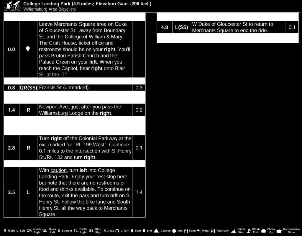
23 College Landing Park Starting Point: Merchants Square Difficulty: Easy Distance: 4.9 miles Climb: 206 feet Terrain: Mostly flat. Several hills will challenge beginners. Description: This is an easy ride that starts and ends in the colonial area and heads south on the Colonial Parkway. The Parkway riding, although on coarse embedded river rock paving, is always enjoyable and beautiful, especially in the spring and fall. Just before Rt. 199, you turn off the Parkway and head back towards Williamsburg on South Henry Street s bike lane. Turn left off of S. Henry into College Landing Park and enjoy great views of College Creek. After your break, continue up a short hill on S. Henry Street and follow the bike lane back to Merchants Square. Restrooms are available at the ride s start. Page 17

24 Page 18

25 Page 19

26 Queens Lake Loop Starting Point: Merchants Square Difficulty: Casual Distance: 12.7 miles Climb: 366 feet Terrain: Mostly flat. Several hills will challenge beginners. Description: Starting in the colonial area, the Queens Lake Loop takes the cyclists on an easy ride to the Queens Lake District of York County. The few hills are easily manageable, even for beginners. Expect to experience some, but not heavy traffic. Halfway through the ride, stop at the spillway area of Queens Lake to take in nice views of the lake as well as Queens Creek and its marina. About ½ way through the ride, take a break at New Quarter Park. The route utilizes the Colonial Parkway for a mile and a half on the return ride back to Merchants Square. The tour could be extended with additional cycling through the Historic District of Colonial Williamsburg. Restrooms are available at the ride s start. Page 20

27 Page 21


28 Page 22

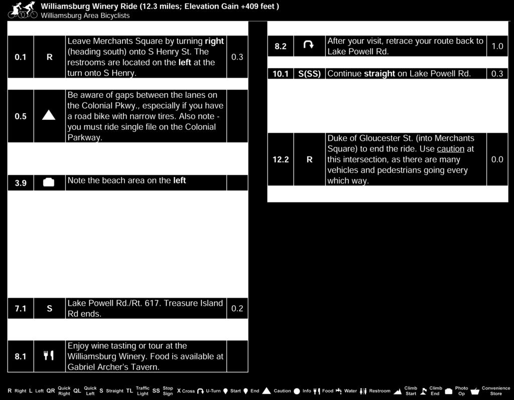
29 Williamsburg Winery Ride Starting Point: Merchants Square Difficulty: Casual Distance: 12.3 miles Climb: 409 feet Terrain: Mostly flat. A few gentle hills. Description: Starting in the colonial area, the Williamsburg Winery Ride is an easy spin down to the James River via the Colonial Parkway. There are a few small hills on the Parkway, but they are easily manageable. When you reach the James River at mile 3.5, consider a stop at the beach area on the left side of the Parkway. Pay close attention to your odometer for the turnoff to Treasure Island Road. A stop at the Williamsburg Winery is always pleasant - whether for a winery tour, wine tasting, lunch, or just the delightful spin through the vineyards. Use caution crossing Rt. 199 on your way back to Merchants Square on Jamestown Road. Restrooms are available at the ride s start and at the Williamsburg Winery. Page 23

30 Page 24

31 Page 25


32 Redoubt Park Starting Point: Merchants Square Difficulty: Easy Distance: 5.5 miles Climb: 102 feet Terrain: Mostly flat. A couple of modest hills, yet within anyone s capability. Description: This is an easy ride around the Colonial Williamsburg Historic Area to visit Redoubt Park, a restored Civil War fortification. Along the way, the ride visits area Civil War points of interest. After all, Williamsburg s history did not stop in colonial times. The city of Williamsburg was captured early in the Civil War and was occupied by Union forces for the majority of the war. The Battle of Williamsburg on May 5, 1862 was a key event in the Peninsula Campaign. Redoubt Park preserves one of the original fortifications and is open free to the public during daylight hours. Restrooms are available at the ride s start and finish as well as at the Quarterpath Recreation Center on Quarterpath Road. Page 26

33 Page 27


34 Page 28

35 Page 29


36 On to Yorktown Starting Point: Merchants Square Difficulty: Moderate Distance: 28.4 miles Climb: 853 feet Terrain: Gently rolling. Description: Starting in the colonial area, this scenic ride takes the cyclist, well, on to Yorktown. There are no difficult hills, but do expect a number of gentle rollers. The Colonial Parkway does contain some areas where the road surface is notoriously rough, but most riders feel the experience of cycling such a historic and picturesque byway is worth the few rattles. Once in Yorktown, consider touring the Battlefields and Encampment Tour Roads if you re looking for a few extra miles. You can also take in the Watermen s Museum, the Yorktown Victory Center or eat at one of the many eateries along Water Street. Since the ride on out to the Colonial Parkway was via Penniman Road, the return trip will take the Colonial Parkway all the way to Williamsburg for more variety. The Colonial Parkway can carry considerable traffic, especially during evening rush hour, but the road s extra width makes the cycling fairly comfortable. The market at mile 2.9 early into the ride is a good place to pick up supplies if you need any. Restrooms are available at the ride s start and at various locations in Yorktown. Page 30

37 Page 31


38 Page 32


39 Yorktown Battlefields Starting Point: York Hall (Old Courthouse), Yorktown Difficulty: Easy (9.1 miles), Casual (12.5 miles) Distance: 9.1 or 12.5 miles Climb: 277 feet Terrain: Mostly flat. A few gentle hills. Description: This short and easy ride leaving from Historic Yorktown primarily follows the Battlefield and Allied Encampment Tours, part of the Colonial National Historic Park. Though many cyclists bike the tour roads without a pass, please keep in mind that an entrance fee is indeed required, and that the Williamsburg Area Bicyclists recommend you purchase a park permit before you enter the Tour Roads. You can purchase a 7-day, yearly or a combination pass that also admits you to Historic Jamestowne. The tour is mostly flat with a few hills that are not very difficult, even for beginners. Interpretive signs are located all along the tour offering insight to the Siege of Yorktown, the last major battle of the American Revolution. Consider extending your bike tour with short out-and-backs to Redoubts 9 and 10, the Moore House and General Washington s Headquarters. These stops are highlighted on the Park brochure/map, which will make your tour of the battlefield area more meaningful. You can pick up your permit and park brochure at the Yorktown Visitor Center either before your ride or during, as it is located just ½-mile into the ride. Those wishing for 3.4 additional miles should complete the French Encampment Loop. Traffic is extremely light, slow and one-way through most of this tour. Use caution of the short segments along Goosley and Cook Roads. Restrooms are available at the Yorktown Visitor Center. Page 33

40 Page 34


41 Page 35

42 A Fine and Dandy Ride Starting Point: York Hall (Old Courthouse), Yorktown Difficulty: Casual Distance: 17.4 miles Climb: 230 feet Terrain: Flat, with several gentle slopes. Description: This easy ride out of Historic Yorktown is basically an out-and-back ride to York County s Dandy area, a peninsula bounded by Back Creek and the York River. Mostly residential, the route carries relatively light traffic making it extremely popular with local cycling clubs. There are no stores along the route but you can find a restroom at Back Creek Park along Goodwin Neck Road. If you are looking to extend your ride, you can enter the Historical Tour Road by turning left at mile 15.0 into Surrender Field. Keep in mind that bicyclists should possess a park pass to bike the tour roads (see ride 9). Restrooms can be found at various businesses in Yorktown as well as the Yorktown Visitor Center ½-mile into the ride. Page 36

43 Page 37


44 Page 38

45 Dare to Ride Starting Point: York Hall (Old Courthouse), Yorktown Difficulty: Moderate Distance: 30.3 miles Climb: 383 feet Terrain: Flat, with several gentle slopes. Description: Dare to Ride takes the Dandy Loop and extends it to the popular biking areas of Seaford and Dare. Mostly residential, but be prepared for more traffic in the Seaford area and use caution when biking narrow Seaford Road. The route passes several stores that make convenient rest stops. If you are looking to extend your ride, you can enter the Historical Tour Road by turning left at mile 28.2 into Surrender Field. Keep in mind that bicyclists should possess a park pass to bike the tour roads (see the Yorktown Battlefield ride). Restrooms can be found at various businesses in Yorktown as well as the Yorktown Visitor Center ½-mile into the ride and the several stores along the route. Page 39

46 Page 40


47 Page 41


48 Historic Jamestowne Island Starting Point: Jamestown Settlement Difficulty: Easy Distance: 8.1 or 6.1 miles Climb: 47 feet Terrain: Flat. Description: This short tour of Jamestown Island is the easiest and safest bike tour offered in this book. Because of the 15 mph speed limit posted on the Island Tour Roads, this is your best choice if you are beginner or have young children. The island offers two loops: a shorter one of 3 miles and a longer 5 mile version. When starting at the Jamestown Settlement Parking Area as described here, you add on another 1.5 miles each way biking to and from the island loops. If you re really looking at a shorter length, then consider driving into the Park and starting at the Island Information Center. You can cycle as few as 3 miles. The route on the island is in a fee area. Pay the fee inside the Island Information Center. Page 42

49 Page 43


50 Page 44


51 Lake Powell Powhatan Loop Starting Point: Jamestown Settlement Difficulty: Casual Distance: 13.9 miles Climb: 326 feet Terrain: Mostly flat. A few gentle grades. Description: This short ride takes in the Lake Powell area, several miles of the Colonial Parkway and several miles on both the Powhatan Creek Trail and the Virginia Capital Trail. The ride makes a pit stop at the Williamsburg Winery, where you can take a tour of the winery, sample some of the local wines or enjoy a lunch, indoors or out. Be very careful when crossing Rt. 199 at mile 7.9. The Powhatan Creek Trail goes through a beautiful wooded and natural creek bed where abundant wildlife may be observed. The Church on the Main at mile 12 along this trail is the site of a church dating back to the mid 1700 s. Unfortunately not much remains of the church except an outline of the foundation. Restrooms are available at the start and at the Williamsburg Winery. Page 45

52 Page 46


53 Page 47


54 Chippokes Plantation State Park Starting Point: Jamestown Settlement Difficulty: Casual Distance: 15.3 miles Climb: 597 feet Terrain: Mostly flat with a few short hills. Description: The Lower Peninsula may be bounded by the James and York Rivers, but the Jamestown-Scotland Ferry makes for an interesting and delightful excursion to Surry County. The ferry, which is free for cars and bikes, sails approximately every half-hour and takes about twenty minutes to cross the James River. The ride will take you to Chippokes Plantation State Park where you can tour the Chippokes Mansion or a small Farm and Forestry Museum. Restrooms are available at the ride s start, at Chippokes State Park and on the ferry. Consider coupling this route with one of the several others in this book that start at Chippokes if you d like a longer ride. Page 48

55 Page 49


56 Page 50


57 James City Jaunt to Freedom Park Starting Point: Jamestown Settlement Difficulty: Moderate Distance: 25.6 miles Climb: 715 feet Terrain: Mostly flat. A few hills on the Jolly Pond Loop. Description: Though more housing developments continue to sprout in James City County, areas of cool, shady woodlands still remain that make for relaxing cycling. The Jolly Pond and Brick Bat areas are two such areas and are featured on this moderately short tour. This ride also goes to Freedom Park where you can enjoy the beautiful Botanical Gardens and learn about a rare settlement of freed slaves in the 18 th century. You will exit Freedom Park on the paved 2-mile Freedom Park trail that connects to Jolly Pond Road. If you re looking for something shorter, consider eliminating the Jolly Pond Loop, or on your return from Jolly Pond, backtrack directly to Jamestown, eliminating the Brick Bat segment. The ride can be done in either direction. Restrooms are available at the Jamestown Settlement and at Freedom Park. Page 51

58 Page 52


59 Page 53

60 Little Creek Reservoir Starting Point: Little Creek Reservoir Recreation Area Difficulty: Easy Distance: 9.6 miles Climb: 292 feet Terrain: Mostly flat. A few rollers. Description: This is a very easy, low traffic ride around the Little Creek Reservoir and is best ridden in the clockwise direction as shown in the map and cuesheet. After the first few miles, cyclists have an opportunity to stop at a store along Rt. 60 in Toano. Pick up food and drinks to enjoy at a rest stop along the lake or after the ride at the Recreation Area. The second half of the ride is more scenic. Enjoy the lake views as you pedal across the reservoir and through the more wooded areas of the park. Restrooms and snacks are available at the ride s start. Page 54

61 Page 55

62 Page 56

63 Little Creek Reservoir Bigger Hills Starting Point: Little Creek Reservoir Recreation Area Difficulty: Moderate Distance: 22.9 miles Climb: 927 feet Terrain: Mostly flat, with about four hills thrown in for challenge. Description: This tour contains the same route as the Little Creek Reservoir route but with an added loop around Jolly Pond. This route also stops by Freedom Park and traverses the paved Freedom Park Trail. Though the ride is relatively short and traffic is mostly light, the hills make the ride unsuitable for beginner riders. Cyclists will want to maintain a safe speed on the descents, as there are tight turns to negotiate at the bottom of several hills. The nice water views and peace and quiet at Jolly Pond and Little Creek Reservoir provide good opportunities for rest stops. Restrooms and snacks are available at the ride s start and at Freedom Park. Page 57

64 Page 58


65 Page 59


66 Upper James City County Starting Point: Little Creek Reservoir Recreation Area. Difficulty: Moderate Distance: 28.1 miles Climb: 1002 feet Terrain: Mostly gentle, with a few hills for variety. Description: This tour takes the cyclist into the rural areas of northern James City and New Kent Counties. Use caution on the latter segment of Croaker Road as well as the 1.5 mile stretch on Richmond Road / Rt. 60. The last few miles include an easy and enjoyable spin around Little Creek Reservoir. Restrooms are available at the ride s start. Page 60

67 Page 61


68 Page 62


69 Three County Challenge Starting Point: Little Creek Reservoir Recreation Area. Difficulty: Challenging Distance: 49.9 miles Climb: 2000 feet Terrain: Moderate, with hills scattered throughout the ride. Description: The Three County Challenge is a rather long and fairly challenging ride through the rural regions of James City, New Kent and York Counties. Water views are numerous, which include Diascund Creek Reservoir, Little Creek Reservoir, Waller Mill Reservoir, and Barlows Pond. Several stores are located along the route as well as numerous ideal locations for rest stops. Restrooms are available at the ride s start. Page 63

70 Page 64


71 Page 65


72 Page 66


73 James City County Park Tour Starting Point: Chickahominy Riverfront Park. Difficulty: Challenging Distance: 62.5 miles Climb: 1930 feet Terrain: Moderate, with hills scattered throughout the ride. Description: This tour visits most of the fine Parks that are available in James City County. There are a few spots where you ll find some traffic but this route is carefully designed to route you along safer roads and streets. There may be more climbing that you might expect in this area, but no terribly long or difficult climbs primarily going down and up from creek beds. In addition to stops at five area parks (Freedom Park, Little Creek Reservoir Park, Upper County Park, York River State Park and Waller Mill Park), this tour also visits several dedicated paved multi-use paths in the vicinity. These include the Virginia Capital Trail, Freedom Park Trail, Waller Mill Bike Path and Powhatan Creek Trail. There are convenience stores along the route (see map), as well as food opportunities, especially in the latter parts of the route along Richmond Road and Ironbound Road. Page 67

74 Page 68

75 Page 69

76 Page 70


77 Charles City County Metric Century Starting Point: Chickahominy Riverfront Park Difficulty: Challenging Distance: 63.1 miles Climb: 2099 feet Terrain: Moderate, with hills scattered throughout the ride. Description: This tour is a true metric century traversing much of rural Charles City County. You ll find lightly traveled roads and some moderate climbing. Several rest stops and two possible lunch spots are included. About nine miles are on the Virginia Capital Trail which goes from Jamestown to Richmond. Cul s Courthouse Grill in Charles City at about mile 45 is a local club favorite and caters to all the bicyclists on the Virginia Capital Trail. Page 71

78 Page 72


79 Page 73

80 Colonial Parkway Starting Point: Various (see map) Difficulty: Easy to Moderate Distance: 23 miles (37 KM) (full length one way) Climb: 220 feet (full length one way) Terrain: Mostly flat with several gradual climbs. Description: The Colonial National Historic Parkway is 23-mile scenic limited-access roadway that connects the Historic Triangle towns of Jamestown, Williamsburg and Yorktown. The parkway was completed in 1957 and is operated by the National Park Service. The center lane of this three-lane roadway is used only for passing and the maximum speed limit is 45 MPH. The road surface is made of river gravel set in concrete, which causes a relatively bumpy ride on high-pressure road bike tires, but worth it. There are distance markers on the side of the parkway every kilometer starting at Yorktown. These are also noted on the map. The Colonial Parkway scenery is spectacular and several routes in this book incorporate parts of the parkway. There is about a one-mile stretch of the Parkway that tunnels underneath Colonial Williamsburg where bicycles are not permitted. Unfortunately this is not marked in the Eastbound Direction (Jamestown to Yorktown) in advance of the last exit, so planning ahead to bypass the tunnel is prudent. In the following pages you will find detailed routes to bypass the tunnel on lightly traveled streets in Colonial Williamsburg. Restrooms are available at Jamestown Settlement, in Colonial Williamsburg and in Yorktown. Great restaurants are also available in Williamsburg and in Yorktown. There are two short bicycle paths that connect from the parkway to secondary roads near Jamestown. They are marked on the map. These paths can be used to connect to either Neck-O-Land Road or Treasure Island Road. The latter road enables a pleasant ride to the Williamsburg Winery. There are open seams on the Parkway that present hazards for skinny tire road bicycles. Be mindful and cross the seams at an angle. Also be aware that bicycles are to ride single file on the Parkway. The part of the parkway from Williamsburg to Jamestown normally has less traffic than that from Williamsburg to Yorktown, which can get quite busy at times. Page 74

81 Page 75

82 Page 76


83 Page 77

84 Surry Starting Point: Chippokes Plantation State Park. Difficulty: Casual Distance: 19.9 miles Climb: 631 feet Terrain: Mostly flat. A couple of small, easy hills. Description: The Surry ride is an easy spin through the rural Surry County farmlands of peanuts, cotton and soybean. Visit the Farm & Forestry Museum near the start/end to see exhibits representing various stages of farm life. There aren t any other attractions along this route, but there isn t much traffic either. You ll appreciate the solitude of this region it s a welcome reprieve from the busier peninsula. Restrooms are available at the Visitor s Center at the ride s start and in the Surry Government Center when it is open. There are also several restaurants and convenience stores in Surry. Page 78

85 Page 79


86 Page 80

87 Surry County Tour Starting Point: Chippokes Plantation State Park. Difficulty: Moderate Distance: 28.4 miles Climb: 1041 feet Terrain: Mostly flat. Some moderate rolling hills. Description: This Tour includes some of the same roads as the Surry ride but adds more miles north and west of Surry through pleasant and lightly traveled roads in rural Surry County. As with the other rides starting a Chippokes, either before or after the ride you may want to visit the Farm & Forestry Museum near the start/end to see exhibits representing various stages of farm life. Restrooms are available at the Visitor s Center at the ride s start and in the Surry Government Center when it is open. There are also several restaurants and convenience stores in Surry. Page 81

88 Page 82


89 Page 83

90 Smithfield Bakery Starting Point: Chippokes Plantation State Park. Difficulty: Challenging Distance: 42.8 miles Climb: 1207 feet Terrain: Mostly flat, with some moderate rolling hills. Description: This ride in Surry and Isle of Wight Counties is one of the bike club s most popular. Though fairly long at 42.7 miles, this ride is best classified as moderate, as the terrain is very mild and contains just a few short rollers. The bakery is one of the club s favorite lunch stops and you won t leave disappointed (or hungry). There s also a small museum in town that s free and delightful to stroll through. Restrooms are available at the ride s start in the Park Visitors Center, and you will pass a convenience store twice at mile 3.8 and again at There are also two sightseeing opportunities on this ride. Visit the Farm & Forestry Museum near the start/end to see exhibits representing various stages of farm life. Visit Bacon s Castle at mile 37.4 to tour the nation s oldest brick dwelling and site of a political uprising in Page 84

91 Page 85


92 Page 86


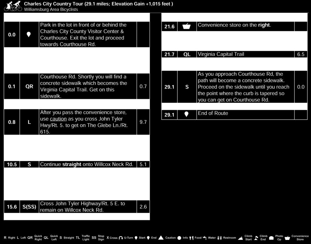
93 Charles City Country Tour Starting Point: Charles City County Government and School Difficulty: Moderate Administration Building. Distance: 29.1 miles Climb: 1015 feet Terrain: Mostly flat. A few long but gradual grades. Description: This is a moderate ride through the rural farms and woodlands of Charles City County and about seven miles on the Virginia Capital Trail. Use caution crossing Route 5 in several places. This route offers ideal cycling conditions: low traffic, well maintained country roads and plenty of peace and quiet. Consider combining your bike tour with a visit to one of the popular plantations that abound near Route 5. There are also two popular lunch spots on the routes. Cul s Courthouse Grill at the start/end has become a local cyclist favorite. The other option is the Blue Heron Restaurant at Rivers Rest Marina at about mile 18. Here you can enjoy lunch on the deck overlooking the marina on the Chickahominy River. Page 87

94 Page 88

95 Page 89


96 Providence Forge Starting Point: Charles City County Government and Difficulty: Challenging School Administration Building Distance: 42.6 miles Climb: 1480 feet Terrain: Moderate. A few long, gradual grades with a few steeper hills. Description: The Providence Forge ride duplicates the first 24 miles of the Charles City Country Tour and then turns north to offer cyclists a welcome break at one of several stores in Providence Forge. The challenge is more due to the ride s length than its terrain. Use caution crossing Route 5, on a 2-mile section of Rt. 155 and on the short segment of Route 60. The rest of the route offers ideal cycling conditions: low traffic, well maintained country roads and plenty of peace and quiet. Consider combining your bike tour with a visit to one of the popular plantations that abound near Route 5 or plan a lunch at Cul s Courthouse Grill (at the start/end) or the Blue Heron Restaurant at about mile 19. Page 90

97 Page 91


98 Page 92

 entirely on the trail.")
99 Virginia Capital Trail Starting Point: Various. Difficulty: Easy to Challenging Distance: Up to 52 miles (one way). Terrain: Mostly flat. Some moderate rolling hills. Description: The Virginia Capital Trail is a dedicated, paved pedestrian and bicycle trail that connects the Commonwealth s past and present capitals of Jamestown and Richmond along the Scenic Route 5 corridor. The Trail traverses approximately 52 miles, four jurisdictions, and more than 400 years of history along one of the first inland routes in North America. Many of the rides in this book incorporate sections of the Virginia Capital Trail. However one can now complete a true 100-mile century (out and back) entirely on the trail. Parking is available at various locations along the trail (see map), so you can tailor a route based upon your preferences. Popular start points near Williamsburg are the Jamestown Settlement and the Chickahominy Riverfront Park. Both sites have abundant parking and nearby restrooms. Cul s Courthouse Grille in Charles City is a favorite lunch destination and caters to bicyclists on the trail. Parking and restrooms are also available at Charles City if you decide to start there and explore the trail further west towards Richmond. If you d like to mix some history with your bicycling, consider a stop by one of the many plantations that are convenient to the trail. Page 93

100 Page 94

101 Page 95

102 Williamsburg Area Bicycle Rides offers 26 bicycle routes in and around the Williamsburg, Virginia region. Grab this guidebook and hit the road on a tour loaded with extraordinary scenery and fascinating history. These carefully designed routes, which range from 5 to 63 miles, offer: Full color professionally designed maps Detailed cuesheets, many with route distance options Full color photos Difficulty, distance, terrain and climb information for each route Local attractions, history, festivals and events Whether you are an emerging enthusiast, experienced racer or just looking for a safe family ride, you ll find routes in the Williamsburg area that are perfect for your ability level and interest. Bonus! Enclosed is a credit-card sized USB flash drive containing printable PDF files of the maps and cuesheets in this book. It also contains GPS navigation files (both GPX and TCX)! Published by: Williamsburg Area Bicyclists P.O. Box 2222 Williamsburg, VA Page 96 Profits from sales used to promote bicycling in the Williamsburg area
T R A F F I C S K IL L S 101
 page 1/5 GENERAL INSTRUCTIONS Mark your answers on the answer sheet provided. DO NOT make any marks on the test. Please read the following definitions and assumptions carefully before answering the test
Local Guide. Napa Valley Tour de Cure. Sunday, May 3, Questions? Contact Us Tom Hall 888-DIABETES, 7460 diabetes.
 Local Guide Napa Valley Tour de Cure Sunday, May 3, 2009 Questions? Contact Us Tom Hall, 7460 thall@diabetes.org 1900 Powell Street, Ste. 120 Emeryville, CA 94608 Route Highlights 100 miles: 50 miles:
Bicycle Safety Presented by: Name
 e l c y c Bi Safety Presented by: Name Questions? Who should wear a helmet? Little kids Where and when should a helmet be worn? Answers! Everyone. Every time. Everywhere. Moms & Dads On the bike path
BikeEd Need to Know: Teenager / Adult
 BikeEd Need to Know: Teenager / Adult Always Practice bike handling skills to better control your bike Wear a helmet, fitted correctly Perform ABC Quick Check on your bike before each ride Ride on the
Williamsburg Convention. October 16-19, 19, Williamsburg Hospitality House. At the
 Williamsburg Convention October 16-19, 19, 2003 At the Williamsburg Hospitality House Hosted by Jim and Betty Villers Special thanks to Dieter Ritter for his support and thanks to the Mercedes-Benz Corporation
BASIC BIKE COMMUTING. A guide for getting started
 BASIC BIKE COMMUTING A guide for getting started Why Bike? The average American spends 55 minutes a day behind the wheel of an automobile and over $7,500 a year on transportation costs. Bicycles, however,
Group Riding Techniques
 Group Riding Techniques Revised: 2017 01 26 A. Group Riding Terminology Thanks to the Ottawa Bicycle Club for allowing us to use content from their website! A.1 Groups and Packs A group is several cyclists
I Cycle Safely. A Little Book with a Big Message
 I Cycle Safely A Little Book with a Big Message Cycle Safely Program Why Cycle? It s fun! It s healthy! It s good for the environment! Here is your own I Cycle Safely pocket book. It s a little book with
EVENT GUIDE. Event Guide 1
 EVENT GUIDE Event Guide 1 Welcome to the V Foundation s Inaugural Victory Ride to Cure Cancer! Thank you for being a part of this special event. To prepare for the event and to know what to expect before,
NEVADA BICYCLING GUIDE
 NEVADA BICYCLING GUIDE BE BICYCLE SAFE EVERY TIME YOU RIDE LET S ALL BE SAFE TOGETHER. In Case of Emergency Contact: Name: Phone: Relationship: REMEMBER TO ALWAYS, BE SAFE AND BE SEEN! Before you head
-Lexington Mayor, Jim Gray
 DWIN Ride on over to Lexington, and enjoy some of the most beautiful countryside anywhere. Our trails and major roadway bike lanes have helped achieve bronze-level status from the League of American Bicyclists,
Broaddus Loop. Lufkin & Angelina County Bicycle Route. Total Miles:
 Lufkin & Angelina County Bicycle Route Total Miles: 72.6 www.visitlufkin.com Route Directions: Segment Distance Direction of Total Distance Road Traveled (miles) Turn (miles) Start Lufkin High School
Denmark East Jutland Biking Tour 2019 Individual Self-Guided 7 days / 6 nights
 Denmark East Jutland Biking Tour 2019 Individual Self-Guided 7 days / 6 nights Aarhus was been named European Capital of Culture 2017 - and not without reason. It boasts of cozy cobblestone streets, charming
Parental Responsibilities
 Bicycle riding is a fun way to exercise and enjoy the outdoors. To remain safe on Illinois roads, bicyclists must obey the same traffic safety laws that govern vehicle drivers. No amount of bicycle safety
Organize a rodeo in your community by following the steps below: 1. Decide when and where to have your rodeo.
 A bicycle rodeo is a skills course for kids designed to be fun, interactive, and noncompetitive. A rodeo is a great way to introduce bike handling and traffic safety skills in a controlled environment
August 26 th Bike Pittsburgh presents. Southside Riverfront Park 1 S. 18th St. (Under the Birmingham Bridge)
") Bike Pittsburgh presents August 26 th 2018 Southside Riverfront Park 1 S. 18th St. (Under the Birmingham Bridge) 7am 8am 9am 10am START TIMES 62 Mile BikePGH Challenge 40 Mile Alco Parking Grand Tour 25
Bike Pittsburgh presents August 26 th 2018 Southside Riverfront Park 1 S. 18th St. (Under the Birmingham Bridge) 7am 8am 9am 10am START TIMES 62 Mile BikePGH Challenge 40 Mile Alco Parking Grand Tour 25
A LIFESTYLE FOR A LIFETIME
 Membership A LIFESTYLE FOR A LIFETIME Located in the heart of some of nature s most masterful handiwork, Two Rivers Country Club is full of all the things that make life special an inviting atmosphere,
Biking is good for your health and the environment too. Have fun and ride safely! young cyclist s guide
 Biking is good for your health and the environment too. Have fun and ride safely! young cyclist s guide what this guide is about Biking is a fun activity that gives you the freedom to go places. It s a
Gravel Bike Guide Haywood County
 Gravel Bike Guide Haywood County Haywood County is an ideal place for bicycling on gravel roads, because 37% or 129,994 acres of Haywood County is federal property, including portions of the Pisgah National
Calaveras Big Trees State Park--South Grove Loop
 Copyright 1999 by Jeff Robinson. You are free to use and reproduce this description for personal, not-for-profit, and not-forbusiness use. Any reproduction other than for personal use, including businesses,
Bicycle. for parents and youth
 Bicycle & Pedestrian Safety for parents and youth A project of Traffic Safe Communities Network (TSCN) in Santa Clara County In collaboration with the Trauma Center at Stanford University Medical Center,
Cycling handbook Your guide to cycling in Oakville
 Cycling handbook Your guide to cycling in Oakville 05 Ensure a proper fit 11 Safety and preparedness 17 Where can I ride? 23 Cycling laws and rules 35 Bikes and public transit 38 For more information A
RAINSTORM Welcome to our 12th year! Host hotel. Indiana State Park Inns. Laundry service
 RAINSTORM 2019 Host hotel Hampton Inn Richmond, 455 Commerce Road, Richmond, Indiana, 47374. Phone: 765-966-5200. The option to reserve a room at the host hotel was available when you registered. You may
Freewheelers (7-8) Mechanics (7-8) Food Cart. Seekers (7-8) Food Cart. Cruisers (5-6) Food Cart. Seekers (7-8) Girls Mechanics (7-8) Food Cart
 Mechanics (7-8) Food Cart. Seekers (7-8) Food Cart. Cruisers (5-6) Food Cart. Seekers (7-8) Girls Mechanics (7-8) Food Cart") 3 day camp 4 day camp Week 1 6/10-6/14 Week 2 6/17-6/21 Week 3 6/24-6/28 Week 4 7/1-7/3 Week 5 7/8-7/11 Week 6 7/15-7/19 Week 7 7/22-7/26 Week 8 7/29-8/2 Week 9 8/5-8/9 Week 10 8/12-8/16 Week 11 8/19-8/23
3 day camp 4 day camp Week 1 6/10-6/14 Week 2 6/17-6/21 Week 3 6/24-6/28 Week 4 7/1-7/3 Week 5 7/8-7/11 Week 6 7/15-7/19 Week 7 7/22-7/26 Week 8 7/29-8/2 Week 9 8/5-8/9 Week 10 8/12-8/16 Week 11 8/19-8/23
DATE: June 22, General Release SUBMITTED BY: LAND DEVELOPMENT SERVICES. RE: City Centre Survey Results
 DATE: June 22, 2018 TO: General Release SUBMITTED BY: LAND DEVELOPMENT SERVICES RE: City Centre Survey Results The following is a summary of preliminary findings for the Community Identity and Vision survey.
This is the Quick Start Guide for the Optibike Pioneer Allroad electric bicycle. The Guide provides for basic information required to ride the
 This is the Quick Start Guide for the Optibike Pioneer Allroad electric bicycle. The Guide provides for basic information required to ride the Allroad. It is not intended to be an extensive manual. It
Italy Tuscany in One Hotel Bike Tour 2018 Individual Self-Guided 8 days/7 nights
 Italy Tuscany in One Hotel Bike Tour 2018 Individual Self-Guided 8 days/7 nights Traveltripjourney.blogspot.com Simply thinking about this popular region puts a smile on a lot of people s faces! The many
Birmingham Bicycle Club
 Birmingham Bicycle Club Ride Leader Guidelines Thank you for your interest in leading a ride for the Birmingham Bicycle Club! Group rides are a major offering of our club. Ride leaders provide the opportunity
Jersey Shore Touring Society Rider Guidelines Revision 1.0 Last Updated 5/9/2008
 Jersey Shore Touring Society Rider Guidelines Revision 1.0 Last Updated 5/9/2008 Version History VERSION NUMBER REVISION DATE EDITOR SUMMARY OF CHANGE 0.1 3/5/2008 Laury Wills Initial Draft 0.2 3/11/2008
Traffic Signs and Signals
 CHAPTER FOUR Traffic Signs and Signals Traffic signs control traffic flow, making streets and highways safer for drivers, bicyclists and pedestrians. These signs, which are posted by the Indiana Department
Team Pit Set-up Teams may set up their pits starting Saturday at 11:00 am. Pre-Ride Saturday and Sunday. Race Day Support. Volunteering at our Events
 RACE 3 Browns Creek April 27-28, 2019 1910 E Broad St, Elizabethtown, NC 28337 Race Description Singletracks.com states that Browns Creek has everything your looking for in a bike trail. Punchy climbs,
Bicycles and Pedestrians on ISU Campus. Indiana State University Police
 Bicycles and Pedestrians on ISU Campus Indiana State University Police FASTEST Transportation On Campus There has been an increase in cyclists and pedestrians on campus as student enrollment continues
North Dakota State University Bicycle Safety & Rules of the Road
 North Dakota State University Bicycle Safety & Rules of the Road I. Introduction Bicycling is a fun and healthy exercise. Before riding your bicycle on roadways, take time to learn the rules. Many bicyclists
BICYCLE SAFETY: A PARENT S GUIDE
 BICYCLE SAFETY: A PARENT S GUIDE Thank you for partnering with the Newport Beach Police Department to help make your child a safer bicyclist. BE A ROLL MODEL LEARN. As a parent, it is important that you
Route 12 Companion Map East Cavalry Field 5.2 miles
 Bicycling Gettysburg National Military Park Route 12 Companion Map East Cavalry Field 5.2 miles For expert road bicyclists only. NOT FOR CHILDREN. Sue Thibodeau Bicycling Gettysburg National Military Park:
Bicycle Safety Skills
 Bicycle Safety Skills Presented by: MassBike Cape and Islands Chapter MassBike John Fallender December 20, 2010 Cape & Islands Chapter 1 Welcome to Cape Cod 2 Bikes are vehicles? What does that mean? That
[DRAFT] Bicycle Parking & Removal
![[DRAFT] Bicycle Parking & Removal](/thumbs/78/76931309.jpg "[DRAFT] Bicycle Parking & Removal") [DRAFT] Bicycle Parking & Removal Policy Type: Administrative Responsible Office: VCU Office of Sustainability, Facilities Management, Division of Administration Initial Policy Approved: MM/DD/YYYY Current
[DRAFT] Bicycle Parking & Removal Policy Type: Administrative Responsible Office: VCU Office of Sustainability, Facilities Management, Division of Administration Initial Policy Approved: MM/DD/YYYY Current
City of Coronado Bicycle Map, Schools, Traffic Signals and Crossing Guard Locations
 City of Coronado Bicycle Map, Schools, Traffic Signals and Crossing Guard Locations Early Childhood Development Center Crossing Guard - AM Crossing Guard - PM Coronado Middle Village Elementary Coronado
2016 Brown County Epic Mountain Bike Festival General Information
 2016 Brown County Epic Mountain Bike Festival General Information Brown County Epic Registration Information *2016 Epic Rides will take place on Saturday again this year. Event camping offered Thursday
Controlled. Semi-Controlled PAGE 01 CHAPTER 12 INTERSECTIONS
 PAGE 01 CHAPTER 12 INTERSECTIONS You will cross many intersections while driving. Intersections are especially dangerous because vehicles are crossing each other s driving path. Many crashes happen at
Everyday Hazards for School Bus Drivers. Reference Guide and Test
 1 Everyday Hazards for School Bus Drivers Reference Guide and Test 2 Introduction One of the most important and often overlooked issues for school bus drivers is hazards. During the course of the video,
Androscoggin River Trail Access Sites. Mahoosucs. 168 miles from its source at Lake Umbagog to Merrymeeting Bay
 Androscoggin River Trail Access Sites Mahoosucs 168 miles from its source at Lake Umbagog to Merrymeeting Bay Trail Under Construction More than 40 Public Access Sites Available Androscoggin River Watershed
Portugal Biking Experiences Cycling through the North of Portugal. Looking for unique biking tours? Check out our website at
 Portugal Biking Experiences Cycling through the North of Portugal Looking for unique biking tours? Check out our website at www.authentictrails.com. About us 16 years of ground experience in destination
Germany - Baltic Sea, Hanseatic Cities & Old Salt Route Cycle Tour 2018 Individual Self-Guided 8 days/ 7 nights
 Germany - Baltic Sea, Hanseatic Cities & Old Salt Route Cycle Tour 2018 Individual Self-Guided 8 days/ 7 nights This tour takes you along the Baltic Coast cycle path from Lübeck to Wismar. Both Hanseatic
CITY OF ARVADA BICYCLE FACILITY NEEDS
 CITY OF ARVADA BICYCLE FACILITY NEEDS The City of Arvada is interested in your ideas and needs as a bicyclist. Your input will help ensure a high level of service for all bicyclists. Did you notice an
49 th DALMAC. Dick Allen Lansing to Mackinaw. Photo from the Little Traverse Wheelway
 49 th DALMAC Dick Allen Lansing to Mackinaw Photo from the Little Traverse Wheelway Wednesday, August 28 Sunday, September 1, 2019 TRI-COUNTY BICYCLE ASSOCIATION SHARE THE ROAD! SHARE THE APPLICATION!
VIRGINIA VAGABONDS AVA 365
 MAP TO PIG POINT START POINT: VIRGINIA VAGABONDS AVA 365 Five Seasonal Walking Events January 1 thru June 30, 2013 A AWARDS MAP TO SOUTH MILLS START POINT: SANCTION: These events are sanctioned by the
Germany Bike Adventure Mosel Rhine 2019 Individual Self-Guided 7 days / 6 nights
 Germany Bike Adventure Mosel Rhine 2019 Individual Self-Guided 7 days / 6 nights A cycling tour along the Moselle cycle route not only makes a wine connoisseur s heart beat faster. The Moselle is one of
Currie Rd to Davidson Park
 Currie Rd to Davidson Park 3 hrs 7.2 km One way Moderate track 28m Starting at Currie Rd in Forestville, this walk follows Middle Harbour to Davidson Park, under Roseville Bridge. There are two optional
Comments EXECUTIVE SUMMARY
 Comments 1. Under any Alternatives, MCDOT should provide better at-grade pedestrian crossing of Georgia Avenue and Forest Glen Road, including improved crosswalks with wider medians and adequate signal
DRAFT. System Components. Greenway Trails. Introduction. Trail Types. Zebulon Greenway Master Plan
 5 System Components Wakefield Street Photo Simulation showing Sharrows Introduction The Master Plan identifies various system components that, together, create a comprehensive greenway system. These components
When on the road When turning When avoiding hazards. This is NOT a straight line: This is NOT a straight line: This is NOT a straight line:
 RIDE IN A STRAIGHT LINE When on the road When turning When avoiding hazards This is NOT a straight line: This is NOT a straight line: This is NOT a straight line: STAY TOGETHER No more than bike length
Application to AASHTO to recognize six suggested relocations of U.S. Bicycle Route 1 in the Northern Virginia District.
 September 7 th, 2007 Application to AASHTO to recognize six suggested relocations of U.S. Bicycle Route 1 in the Northern Virginia District. Acting District Administrator Mr. Morteza Salehi has endorsed
Bicycle Book. This book belongs to. Name. Address. Telephone number. Make of bicycle. Color of bicycle. Serial number.
 Bicycle Book Bicycle Book This book belongs to Name Address Telephone number Make of bicycle Color of bicycle Serial number License number Other identifying marks Transportation and Public Works Road Safety
Encouragement. Chapter 4. Education Encouragement Enforcement Engineering & Facilities Evaluation & Planning. Encouragement Chapter 4
 Encouragement Education Encouragement Enforcement Engineering & Facilities Evaluation & Planning Photo above: Children show off their ribbons at the Tour de Virginia Beach. Virginia Beach Bikeways and
Table of Contents Introduction. 2 Purpose of the Plan...2 The Benefits of Walking and Bicycling...3 Vision and Goals of the Plan...
 BICYCLE AND This plan was created through a grant from the Healthy Communities Program with the cooperation of the City of Cynthiana, Cynthiana Main Street, Cynthiana-Harrison County-Berry Joint Planning
BICYCLE RULES OF THE ROAD
 ILLINOIS ILLINOIS ILLINOIS ILLINOIS ILLINOIS ILLINOIS ILLINOIS ILLINOIS BICYCLE RULES OF THE ROAD Jesse White Secretary of State Bicycle riding is a great way to get into shape and enjoy the outdoors.
What are the Qualities that make Newark a Bicycle Friendly Community? What are aspects that make Newark less Bicycle Friendly?
 What are the Qualities that make Newark a Bicycle Friendly Community? Many stores are within biking distance (1) Lots of bike lanes and new trail Existing bike routes (2) Designated bike lanes on Del ave.
France South Burgundy Bike Tour 2018 Individual Self-Guided 8 days / 7 nights
 France South Burgundy Bike Tour 2018 Individual Self-Guided 8 days / 7 nights Famous wines of Côte d Or and one of the most varied and finest cuisines of France are the first things you think of when hearing
Heartwood Forest, in Sandridge, Hertfordshire, is a place where everyone can find space, peace, wildlife and miles of beautiful woodland to explore.
 Heartwood Forest Accessibility Statement September 2016 Purpose: This accessibility statement outlines the available facilities and access information for Heartwood Forest. Welcome We, the Woodland Trust,
Fish Lake Team Relay Course Information 2016
 Fish Lake Team Relay Course Information 2016 Fish Lake Team Relay Course Information 2016 The Fish Lake Team Relay begins at Fish Lake Lodge on the shores of beautiful Fish Lake located in Sevier County,
WALK- AND bike-friendly TURLOCK
 WALK- AND bike-friendly TURLOCK Ideas to Encourage Walking and Biking Benefits to the COMMUNITY Get Connected People who walk and bike have many more opportunities for casual interactions with friends
Promoting Cycle Tourism
 Contents of Workshop Who are you & where do you come from? Promoting Cycle Tourism Katharine Taylor, Sustrans Colin Simpson, The Highland Council What is Cycle Tourism? What has your area got to offer
Niagara Cycling Tourism. Presented by: Susan Morin Prepared by Karine Whittingham May 5th, 2014
 Niagara Cycling Tourism Presented by: Susan Morin Prepared by Karine Whittingham May 5th, 2014 Agenda! Why Cycling Tourism! Economic Impact! Objective & Activities! Stakeholders! Product Development! Bicycle
Belgium Bruges for Kids Bike Tour (2018) Individual Self-guided 7 days / 6 nights
 Individual Self-guided 7 days / 6 nights") Belgium Bruges for Kids Bike Tour (2018) Individual Self-guided 7 days / 6 nights A truly surprising holiday! The region between the Belgian coast and the stunning city of Bruges is a very special one,
Belgium Bruges for Kids Bike Tour (2018) Individual Self-guided 7 days / 6 nights A truly surprising holiday! The region between the Belgian coast and the stunning city of Bruges is a very special one,
Corpus Christi Metropolitan Transportation Plan Fiscal Year Introduction:
 Introduction: The Safe, Accountable, Flexible, Efficient Transportation Equity Act: A Legacy for Users (SAFETEA-LU) has continued the efforts started through the Intermodal Surface Transportation Efficiency
OUR WORLD... SARDINIA ROAD CYCLING S E P T E M B E R
 WELCOME TO OUR WORLD... SARDINIA ROAD CYCLING 1 5-2 2 S E P T E M B E R 2 0 1 8 Sardinia cycling OVERVIEW Mellow Jersey has teamed up with SardiniaCycling to offer an enchanting experience in this popular
Winnipeg Walk Bike Projects Downtown Tire Talk - Summary
 Winnipeg Walk Bike Projects Downtown Tire Talk - Summary Downtown Projected Bike Lane System Connecting The Forks to the Exchange District (Fort Street, Garry Street & The Forks to Assiniboine Connection)
BP MS 150: New Rider Orientation
 BP MS 150: New Rider Orientation November 19, 2014 Remember why we ride To STOP MS MS is an autoimmune disease that affects the central nervous system of nearly half a million Americans. Currently there
Tour de Moore Classic
 Tour de Moore Classic Rider s Guide Classic North Carolina Bike Rides Contents Tour de Moore Classic North Carolina Classic Rides RIDERS GUIDE Welcome Rider Information Schedule of Events Ride Maps History
Bike Safety It Starts With You!
 The law defines the bicycle as a vehicle that belongs on the road. Riding on the road means that you are mixing with other traffic, and it is only safe when all vehicles in traffic use the same rules of
Trails that Transform: The Economic Impact of Bicycle Tourism
 Trails that Transform: The Economic Impact of Bicycle Tourism September 2016 Economic Growth Summit Alta Planning + Design Nation s leading team of bicycle, pedestrian, greenways, and trails planning and
distance Easy/Moderate
 Experience Rating Easy/Moderate distance 40km (25m) Cycling route: 40km (25 miles) Cycling in: The Great Waterway, Prince Edward County Number of days cycling: 1 Recommended number of nights stay: 2 Experience
Hampton Roads Pedestrian and Bicycle Advisory Committee
 Hampton Roads Pedestrian and Bicycle Advisory Committee Virginia Bicycle and Pedestrian Advisory Committee April 22, 2015 Carl E. Jackson, AICP Transportation Planning Specialist Hampton Roads District
Swamp Road Residents Study
 Swamp Road Residents Study SRRG Meeting with PennDot and Elected Officials Newtown and Wrightstown, PA April 25, 2008 Newtown Township Section of Swamp Road Limited Public Funds No reconstruction of a
Denmark Best of Northern Zealand Bike Tour 2018 Individual Self-Guided 7 days / 6 nights
 Denmark Best of Northern Zealand Bike Tour 2018 Individual Self-Guided 7 days / 6 nights Start and finish in Copenhagen, the Bike Capital of the World. Experiencing Copenhagen on your bike is something
Islands of New England
 Valdosta State University Continuing Education presents Islands of New England June 3 10, 2016 For more information contact Jane Shelton South Georgia Travel Inc. (229) 244-2324 jane@sgatravel.com 8 Days
SAFETY GUIDE FOR SCHOOL CHILDREN & PARENTS. toronto.ca/visionzeroto #VisionZeroTO
 SAFETY GUIDE FOR SCHOOL CHILDREN & PARENTS toronto.ca/visionzeroto #VisionZeroTO VISION ZERO ROAD SAFETY PLAN Toronto s Vision Zero Road Safety Plan is a five-year strategy for eliminating traffic-related
4. Are the turns marked? The turns are not marked.
 Pinelands Preservation Alliance 17 Pemberton Rd, Southampton NJ 08088 609 859 8860 www.pinelandsalliance.org 2016 Tour de Pines FAQs Are you thinking about riding the Tour de Pines but have some questions?
Executive Summary Leadership Cincinnati Class 34. Project: Cinci Bikes
 Executive Summary Leadership Cincinnati Class 34 Project: Cinci Bikes Team Members: Martha Schickledorrf, Jim Kee, Brian Sullivan, Nancy Strassel, Scott Isenhart, Valerie Landell Concept The Cinci Bikes
ADDENDUM TO THE VISUAL EFFECTS ASSESSMENT FOR THE PROPOSED DOMINION VIRGINIA POWER SURRY TO SKIFFES CREEK 500 kv TRANSMISSION LINE
 ADDENDUM TO THE VISUAL EFFECTS ASSESSMENT FOR THE PROPOSED DOMINION VIRGINIA POWER SURRY TO SKIFFES CREEK 500 kv TRANSMISSION LINE GREEN SPRINGS BATTLEFIELD VDHR File No. 2011-2071 Prepared for: Dominion
Copyright by Home by School.com (Third Conversion, LLC). All rights reserved. Published by Third Conversion, LLC
. All rights reserved. Published by Third Conversion, LLC") Copyright 2010-2012 by Home by School.com (Third Conversion, LLC). All rights reserved. Published by Third Conversion, LLC No part of this publication may be reproduced or transmitted in any form or by
Copyright 2010-2012 by Home by School.com (Third Conversion, LLC). All rights reserved. Published by Third Conversion, LLC No part of this publication may be reproduced or transmitted in any form or by
Androscoggin River Trail Access Sites. Mahoosucs. 168 miles from its source at Lake Umbagog to Merrymeeting Bay
 Androscoggin River Trail Access Sites Mahoosucs 168 miles from its source at Lake Umbagog to Merrymeeting Bay Trail Under Construction More than 40 Public Access Sites Available Androscoggin River Watershed
ONTARIO BY BIKE NETWORK
 Business Name: ONTARIO BY BIKE NETWORK Participant Registration Registration is also available and preferred on-line: www.ontariobybike.ca/join-the-network Business Category: Accommodations (incl. Campgrounds)
2015 Brown County Epic Mountain Bike Festival General Information
 2015 Brown County Epic Mountain Bike Festival General Information Brown County Epic Registration Information * Changes in 2015 Epic Rides will take place on Saturday! Demos on Saturday and Sunday Registration
Italy Tuscany in One Hotel Bike Tour 2019 Individual Self-Guided 8 days/7 nights
 Italy Tuscany in One Hotel Bike Tour 2019 Individual Self-Guided 8 days/7 nights Traveltripjourney.blogspot.com Simply thinking about this popular region puts a smile on a lot of people s faces! The many
France Provence Epicure Bicycle Tour 2019 Individual Self- Guided 7 days / 6 nights
 France Provence Epicure Bicycle Tour 2019 Individual Self- Guided 7 days / 6 nights Breath-taking sights of the Mont Ventoux or the lovely hills of the Vaucluse with the famous wine growing area Cote du
Members Guide. Thank you for joining the Bicycle Club of Philadelphia! This guide is designed to answer the most common questions members have.
 Members Guide Most of the information in this Guide comes from the following references available to BCP members: Quick Release (QR) the BCP monthly Newsletter BCP Website www.phillybikeclub.org Email
Bike to School Week: When: Where: Who: 2017 Mayors Ride: National Bike Week: bismanbikes #bismanbikes When: Where:
 Event Highlights Bike to School Week: Join millions of student nationwide by riding your bike to school during national Bike to School Week and Bike Day. Police Officers from Bismarck and Mandan will be
Scotland The Moray Coast and Whisky Bike Tour 2019 Individual Self-guided 8 days / 7 nights
 Scotland The Moray Coast and Whisky Bike Tour 2019 Individual Self-guided 8 days / 7 nights From Inverness, the Capital of the Highlands travel east along the quiet roads of Moray. There are many historical
The TransAm Eastern Express
 The TransAm Eastern Express Welcome to the newest offshoot of the Adventure Cycling Association s historic, TransAmerica Bicycle Route across the U.S. This variation of the TransAm is a natural counterpart
Tour de Wyoming 2015 Route Overview:
 Tour de Wyoming 2015 Route Overview: Route Overview: Gather in Sundance on July 11 Day 1 (July 12): Sundance to Newcastle via Upton Day 2 (July 13): Newcastle to Custer via Wind Cave NP Day 3 (July 14):
157 Chapter 6: Bicycles
 Chapter 6: Bicycles 157 158 Bicycle use continues to increase as more people use a bicycle for transportation, recreation, physical fitness and energy conservation. Cyclists must obey the rules of the
THE OFFICIAL GUIDE TO CYCLING SAFELY IN PHILADELPHIA
 B IKE NICE THE OFFICIAL GUIDE TO CYCLING SAFELY IN PHILADELPHIA A partnership of the City of Philadelphia and the Bicycle Coalition of Greater Philadelphia ABOUT VISION ZERO & BIKE NICE It s a great day
Growing Bicycle Travel & Tourism for Economic Development Jeff Miller, VP North America
 Growing Bicycle Travel & Tourism for Economic Development Jeff Miller, VP North America 202-445-4415 Jeff@CycleLifeHQ.com 1 2 3 4 Growing Bicycle Travel & Tourism for Economic Development Jeff Miller,
PRE-RIDE LOGISTICS. Summary of Key Rider Information SCHEDULED REST/WATER STOP
 Summary of Key Rider Information - Be on time and follow the schedule - Mandatory must wear the bib number on the back of your jersey (attached to the back pocket) at all times, and bike frame number on
Contents. Bicyclist Pocket Guide. Quick Reference. 2nd Edition. GeorgiaBikes.org. 1. Legal Status of Bicyclists Rules of the Road 7
 Bicyclist Pocket Guide 2nd Edition 2013 GeorgiaBikes.org 2 Contents 1. Legal Status of Bicyclists 6 2. Rules of the Road 7 3. Safe Cycling 17 4. Crashes 24 Quick Reference Bicycles are vehicles and have
I Cycle Safely. A Little Book with a Big Message
 I Cycle Safely A Little Book with a Big Message Cycle Safely Program Why Cycle? It s fun! It s healthy! It s good for the environment! Here is your own I Cycle Safely pocket book. It s a little book with
Bar Harbor Route 3 Gateway Project Advisory Committee September 21, 1-3 PM Atlantic Oakes Hotel Minutes
 Bar Harbor Route 3 Gateway Project Advisory Committee September 21, 1-3 PM Atlantic Oakes Hotel Minutes Attending: Dick Cough, Edith Milbury, James Blanchard, Chris Fogg, Paul MacQuinn Millard Billings,
2018 Summer Bike to Work Day Station Host Toolkit
 2018 Summer Bike to Work Day Station Host Toolkit Contents Contact information:... 2 About Bike to Work Day... 3 2018 Bike to Work Day Details... 4 Commitment... 4 Dates to Remember... 5 Station Co-hosts