HILLSBOROUGH COUNTY PUBLIC WORKS TECHNICAL MANUALS AND SPECIFICATIONS 2 YEAR MANDATORY UPDATES (2017) COMMENTS & RESPONSES COMMENT / JUSTIFICATION
|
|
|
- Mariah Walton
- 6 years ago
- Views:
Transcription


1 Services Division 1 County Staff 1.1 Recommend adding a paragraph advising the EOR/developer that all streets within and contiguous to a proposed development must be coordinated with other existing or planned roadways. For additional information refer to LDC A- 16. County to add language to 1.1 County will revise Section 1.4 and County Staff 1.4 & Sections to be updated to reflect new review procedures & 2.1 Please note that FDOT s Plans Preparation Manual and Design Standards are currently under review and are likely to include recommendations from the new Complete Streets Handbook. County acknowledges comment; because these updates are still in draft form we will look to address at a later date.


2 Services Division Staff suggests incorporating a context-based classification for functional classification, per FDOT s Complete Streets Handbook. Staff strongly recommends that the rationale and compelling reasons for sidewalk design exceptions be further defined/clarified and encourages consideration of the approval decision extending beyond the County Engineer. The effect of numerous sidewalk waivers has resulted in gaps in the sidewalk network and expensive subsequent retrofits, particularly in areas that infill over time. Because the Complete Streets Handbook is just coming into fruition and is still in Draft form, it may be wise to wait to implement certain aspects as a rule. Section 1.6 identifies the Florida Green Book as guidelines for establishing the functional classification. Recommend waiting until this 2013 addition is updated, which is being done now to see if any of these changes are adopted here. All Design exceptions are reviewed by PWD staff in great detail and a recommendation is provided to the County Engineer to consider. To exclude a sidewalk it must be approved by the Land Use Hearing Officer. If other agencies need to be consulted they are contacted for their input prior to sending to the County Engineer and recommendations to the hearing Officer. New language will be added to Section & The County is encouraged to consider design speeds based on context classification (Complete Streets Handbook) and revising the TTM to incorporate FDOT s forthcoming guidance for establishing speed in Speed Zoning of Highways, Roads, and Streets in Florida (Speed Zone) (Topic Number ). The Green Book is currently being updated and these things are being considered. Because the Complete Streets Handbook is just coming into fruition it may be wise to wait for a while to implement certain aspects The County is encouraged to add the FDOT Complete Streets Handbook as a reference guide. County to add FDOT s Complete Streets Handbook to 2.1. (See next comment) County to include new language in 2.1, remove all other text references that state except for the requirements of CQC) within all chapters and add Hillsborough County Public Works Specifications for Construction. 8 County Staff 2.1 & 8.0 Several locations in the TTM (especially on 8.0) include a statement about the requirements to meet the FDOT specs except for the requirement of CQC. This has been causing confusion at the field regarding the QC tests required.
3 Services Division 9 County Staff 2.2 Recommend adding a sentence or paragraph informing/directing the EOR that no exceptions within the right of way, such us median islands, shall be plotted as right of way or easement control by any other entity different to the County. County to add statement to 2.2. County to provide specific details (TD-16 7 of 7) on root zone sidewalk protection options and placement of shade/street trees Staff suggests widening the minimum right of way widths to allow for tree planting areas between the curb and sidewalk. If an increase in width is not possible, staff recommends providing root zone protection in the sidewalk/curb and utilizing other best practices for maintaining healthy trees.

 shall comply with the required level of the classification. Is this referring to the proposed road connecting to the existing road or to the existing road?")
4 Services Division County to revise Table 2-1 and all Typical Section Titles to match table. 11 County Staff Table 2-1 The title within the table for TS-7 does not match the title on the typical section itself. Also, other section names may change if other suggested revisions are made. Ensure all typical section names in the table match the names on the section. Also, ensure that any other changes made to the typical sections or new sections added are reflected in the table. County to reference new Section 13 in and County Staff This paragraph is not very clear. Is the first sentence the road(s) shall comply with the required level of the classification. Is this referring to the proposed road connecting to the existing road or to the existing road? If it is referring to the existing road, is this paragraph directing the developer to update the existing road based on the added ADT? If so please make this paragraph clear and concise to what is being requested The County may want to consider language be added requiring a design speed analysis be reviewed if a roadway is identified as a High Crash Roadway. This section of the Manual is referring strictly to new roadways that would not be identified as a High Crash Roadway. This could be considered in Section 12 or our new Section 13, Review of Substandard Roadways.

5 Services Division County agrees and will update County Staff Issues with sidewalk being damaged from large lawn equipment and utility trucks driving on it has been observed since the County reduced the required sidewalk thickness from six inches to four inches. Recommend requiring six-inch sidewalk again for all sidewalk on collectors and arterials.

6 Services Division This protection is for the sidewalk. County is proposing a new paragraph under this section to address shade trees, sidewalk protection options and will reference the new details in this section. County will also add note to TS- 3, TS-4, TS-5, and TS The County may want to consider adding a new Section that speaks to protection of street trees along/adjacent to sidewalks. The length of the required protection is recommended to be five feet on either side of the centerline (longitudinally) of the required tree. This type of protection could be provided in the Typical Sections drawings. Tree protection areas may also reduce the need for ongoing sidewalk maintenance, as well as the associated cost Another method to alleviate traffic would be to promote the development of a local road network. Staff recommends dead end streets and cul-se-sacs be discouraged for subdivisions and planned developments where opportunity for connection to adjacent properties exists. County to add new Complete Streets subsection. Dead end streets and cul-de-sacs are discouraged in subdivisions and planned developments where opportunity for connection to adjacent properties exists.
7 Services Division County to add a paragraph to address that the developer should consider connectivity of pedestrians between developments and provide sidewalks and trails through buffer walls at appropriate locations With respect to buffer walls, staff suggests allowing the opportunity for consideration of openings for a non-motorized trail or sidewalk to create connections between residential areas and schools, parks and light commercial areas. County acknowledges and will update Please delete the reference to the MPO Comprehensive Bicycle Plan and replace with the more recent Pedestrian & Bicycle High Crash Areas Strategic Plan for Unincorporated Hillsborough County Roads (2012) and/or the forthcoming Vision Zero Action Plan (2017), which is currently being reviewed by County staff County Staff Many of the referenced documents for minimum standards have been updated. For example, various American Association of State Highway and Officials (AASHTO) guides have added details on selecting the best facility, allowing for narrowing motor vehicle lanes to create bicycle lanes, and guidance for road diets. Narrower travel lanes may be appropriate in some cases to enhance safety and reduce traffic speeds. The County may also want to consider lowering design speeds for all road classifications in urban settings, per the Speed Zone guidance outlined above. Adding a section on mid-block crossings, including desired spacing in urban and suburban areas, would help increase safety and improve pedestrian access. Recommend clarifying this paragraph as follows: Driveways that have or are anticipated to have a significant amount of daily traffic (greater than 400 vehicles per day) shall be designed as commercial driveways with radial returns and no drop curbs. Staff recommends including crosswalk markings for each leg of the intersection and bicycle detection loops. Acknowledged and will review for any needed updates. This section identifies minimum lanes widths that are consistent with the Green Book for collectors and nonresidential/commercial roads. Subdivision streets design/speeds are set per County ordinance as allowed by State Statue at 25MPH. This would have to go to the BOCC for approval. No changes are recommended. In Section 2 Design Elements, the County references FDOT s Traffic Engineering Manual, which provides guidance in this area. County does not recommend any modifications at this time. County to update Crosswalk markings are being done for all legs at signalized intersections. Each intersection is reviewed to determine what markings are really needed. Installation of bike loops have not been implemented and is not standard practice at this time. Recommend looking at this for future implementation.


8 Services Division Recommend revising and The County may want to consider a minimum width of 6-8 feet for pedestrian refuges in roadways with medians, especially in urban and suburban areas. This is per the Institute of Engineers (ITE) s Designing Walkable Urban Thoroughfares: A Context Sensitive Approach. County to update Website Submittal Suggest clarification that 25 radius is only required where a local road intersects a collector road, not at intersections of local roads To minimize pedestrian crossing distance and reduce speeds in urban settings, the County may want to consider smaller radii as noted in the Florida Department of (FDOT) s Complete Streets Handbook and design manuals. Because Complete Streets is still considered new concepts and FDOT and others are working through details, County recommends waiting for the next update to incorporate major changes to geometrics and curb returns. Projects will be considered individually if new concepts are being proposed that don t meet today s criteria. County to update County Staff 5.3 Recommend adding statement not allowing curb inlets to be placed within handicap drop curb locations or on curb returns. 28 Website Submittal 5.5 Suggest clarification that this criterion applies to collector road intersections and not to local subdivision streets. Or County needs internal discussion between PW and NatRes. No changes. The Engineer of Record is to ensure landscaping does not conflict with sight distance. 29 County Staff 5.6 Traffic analysis needed to support reduced queue? Yes, an analysis is needed to support using the minimum ques lengths. No queue lengths are allowed less than the minimum without a design exception. No changes recommended.
9 Services Division County to update TD County Staff 5.8 & TD-7 Section 5.8 states that the profile shall meet Index 515, however, TD-7 states that this only applies to driveways on collector roads and above. Better guidance in the TTM is suggested. 31 County Staff 5.8 This statement conflicts with Standard Index 515. Not all driveways are concrete. In rural areas most driveways are asphalt and in urban areas great majority of driveways are concrete. However most commercial driveways are constructed with radii and can be built with asphalt or concrete. This may be a better way to address this subject. County to add the word concrete to and update TD-7. See comment above.
10 Services Division County to revise and add drawings TD-13 (2 of 4), TD-13 (3 of 4) and TD-13 (4of 4). Illuminated Street Lighting Bracket arm Detail sheets: The illuminated street name sign bracket arm assembly detail used by FDOT District 7 in the past was analyzed to support illuminated street name signs up to 18 square feet with 130 mph wind loading. The D7 Preferences Index is no longer available; however, the details are provided as needed. Recommend the county to add the details as part of the TTM under TD-13. Details provided with this comment. Recommend verbiage to be changed as follows For fabrications and structural details refer to the Typical Detail TD-13 for Internally Illuminated Street Name Signs. 32 County Staff


11 Services Division County to update County Staff Recommend including a pavement design similar to Chapter 12 for offsite option 3 that provides a design without engineering due diligence.

12 Services Division 34 Website Submittal 8.3 C 35 County Staff Remove SOIL CEMENT BASE SHALL BE USED FOR ON- SITE LOCAL ROADS. Would like the County to consider the review of in place soil cement that has been installed over the last 3-5 years and determine and consider the use of plant produced soil cement to be allowed on all types of roadways. On February 20, 2017, a LDC Hearing denied construction of a timber bridge as part of a subdivision construction permit. Recommend adding a note to 9.3 indicating that no vehicle timber bridges are allowed. When walkways are to be used by both pedestrians and bicyclists, staff recommends enhancing the width to 10 feet, consistent with minimum trail width. The County currently allows soil cement on onsite local roads/subdivision streets per Section 8.3. The County does not recommend allowing soil cement for other roadways due to issues with reflective cracking of the soil cement that is transferred up through the asphalt. No changes recommended. County to add Section Although larger walkways are preferred, cost can be considerable. Additional analysis is required to determine when it would be required to be 10 feet. County to change to and add new Sidewalk Protection from Street Trees language as County Staff 10.4 Recommend adding a requirement to protect trees. Also suggest adding typical section drawings.


13 Services Division County to update Section 12 title, Section 12.6 title and add language for Cross Section Elements. 38 County Staff 12.0 Recommend changing Section 12 s name to Off-Site and On- Site Collectors. Also recommend adding guidance on how to plot roadway cross sections. Request all underground existing utilities must be plotted on all cross section. County to add statement to County Staff Recommend adding sentence directing developers to reference the LDC to comply with the Access Management requirements. County to add language to County Staff 2.5 Recommend adding the following paragraph. A typical section must be provided for each proposed road. Additional typical sections must also be provided for each section of a road for which design elements vary significantly to warrant the need of additional typical sections.

14 Services Division 41 County Staff County Staff County Staff County Staff A more complete list of what is required to be included in a complete set of roadway plans is FDOT PPM Vol. II Chapter 2, Table 2.1. Recommend adding Chapter to Also recommend adding a statement about coordinates being tied to the BL of Survey and/or CL of Construction to the State Plane Coordinates. Recommend adding the following section: Proposed right of way lines must clearly be shown and labeled on the proposed design plans and updated throughout the design phase. The TTM does not really address pavement design for a new collector roadway. Section 8.1.1, directs design for new collector roadway to Section 12. Section 12.9 indicates 3 options that could be used; however, options 2 & 3 apply to widening only. Option 1 is a design based off of traffic counts, but a new roadway does not have traffic counts. This should be more clearly defined Recommend replacing a minimum of one inch milling and resurfacing is required from the paragraph with a minimum of 1 for design speeds 35 MPH or less, and a minimum of 1.5 for design speeds over 35 MPH, milling and resurfacing is required Recommend replacing a minimum of one inch milling and resurfacing is required from the paragraph with a minimum of 1 for design speeds 35 MPH or less, and a minimum of 1.5 for design speeds over 35 MPH, milling and resurfacing is required Recommend replacing a minimum of one inch milling and resurfacing is required from the paragraph with a minimum of 1 for design speeds 35 MPH or less, and a minimum of 1.5 for design speeds over 35 MPH, milling and resurfacing is required Recommend replacing a minimum of one inch milling and resurfacing is required from the paragraph with a minimum of 1 for design speeds 35 MPH or less, and a minimum of 1.5 for design speeds over 35 MPH, milling and resurfacing is required. County to update and add new language under County to update County to revise Option 1 statement in County states cores may be required in to determine the condition for recommendations. County to add new language to

15 Services Division County to revise and County Staff Recommend replacing the following paragraph: All existing pavement markings shall be removed by means of milling and resurfacing a minimum of 1 of asphalt. No water blasting will be allowed. Remove paragraph County to add page to Appendix E with instructions. 46 County Staff Appendix E Recommend adding on Appendix E, instructions for presenting the Soil and Materials Final Report Package for projects asbuilt/close out packages.

16 Services Division There is a contradiction between the TTM and UAG regarding the percent of compaction and the proctor tests. 47 County Staff Appendix E 48 Website Submittal TS-3 There is also contradiction on the compaction requirements defined on the UAG language and the requirements on the Appendix L (Density Testing Schedule) Also recommend revising the TTM Appendix E - Testing Schedule, to reflect the NS concrete (sidewalk, curb & Gutter, traffic separator and dich pavement) acceptance as per FDOT 347. The width of sod should be reduced from 2' 8" to 1' or 2'. The strip of sod is temporary and is removed when the builder grades the right of way and sods the lot. Also please provide clarification regarding restoration of right of way and if sod is the only option or if seed and mulch or hydro seeding is acceptable. County to update testing schedule and all references to ensure consistency. County to revise County to also update TS-2, TS-3, TS-4, TS-5, TS-6, TS-7, TS-8, TS-9, TND-2, TND-3, TND-4, TND-5, TND-6, and TND-7. See comment County Staff TS-3 Suggest adding a flat area behind sidewalk. County to update Drawing TS-3 and TS-9. See comment 15.
17 Services Division County to update TS-7, TS-8, TND-4, TND-5, TND-6, TND TS 7 & TS-8 The typical sections for 2L local rural road and 2LD rural collector indicate a five-foot shoulder as a bike lane; staff suggests clarifying that this means a striped and marked bike lane. 51 County Staff TS-8 The AADT specification (in the middle of the page just below the road base) specifies 5,000 to Less Than 10,000 AADT. What happens above 10,000 AADT? There is no typical which addresses this for rural sections (unlike for urban sections). Suggest creating a 4-lane rural typical. Although it will be rarely used, it will be helpful in determining right-of-way preservation requirements for those roadways shown as a future 4-lane roadway on the Hillsborough County Corridor Preservation Plan (for example, certain roads in the Plant City area). There has not been a need in the past and we don t believe a new four-lane rural typical will be proposed by a developer. No changes recommended.
18 Services Division 52 County Staff TS-9 53 County Staff TS Website Submittal TND-5 TD-1 (2 of 2) If this typical section is only for subdivisions with less than or equal to 10 lots (presumably residential), then why is there a non-residential roadway lane width provided? In the middle of the page just below the road base, recommend modifing as follows RESIDENTIAL SUBDIVISION WITH LESS THAN OR EQUAL TO 10 LOTS. Delete nonresidential land and right-of-way width references. The title of this typical section is too similar to the title of TS-7, which confuses both applicants and staff. Consider renaming the typical section so it more closely mirrors its counterpart TS- 10. Sidewalks are not shown within the typical section. Consider adding a 6 paved shoulder (to accommodate sidewalk requirement), otherwise place note indicating how required sidewalks are to be provided. Regarding a typical section for 4LD urban collector, the County may want to consider 7-foot buffered bike lanes given the 45 mile per hour maximum design speed. The handicapped signage has also changed slightly. Index 17355, sht 2, FTP is different than what is currently shown, and I could not find a parking sign pole that matched the current detail. Commercial site could use this typical. County to update TS-9 title LOW VOLUME PUBLIC ROADS (MINOR SUBDIVISIONS WITH 10 LOTS OR LESS) County to add note to TS WHERE REQUIRED BY THE HILLSBOROUGH COUNTY LAND DEVELOPMENT CODE, SIDEWALKS ARE TO BE PLACED WITHIN OR OUTSIDE OF THE PROPOSED RIGHT-OF-WAY WITHIN AN EASEMENT APPROVED BY THE COUNTY. County to update TND-4, TND-5, TND-6 and TND-7. County to replace current handicapped signage with updated FDOT STD and make a note to allow for FDOT approved aluminum round tube post. 56 County Staff TD-3 Recommend including a better definition of Temporary. County to add note to TD-3 referencing Section 2.10 of.

19 Services Division County to add note to TD-9 requiring all existing sidewalk to be connected. County will also remove MAX column within the table. Recommend adding additional sidewalk to residential road and connecting it to existing road. 57 County Staff TD-9 Consider removing maximum requirements for length A they are not needed and conflicts with the maximum driveway length specification for residential developments within Section A.3. of the Hillsborough County Land Development Code. 58 County Staff TD-9 Regarding the minimum length table, we have received this question from several developers/consultants: does the minimum amount change depending on whether the development is single or multi-family?. In addition, FDOT representatives have expressed concern that this detail does not provide sufficient minimums from developments on state roadways and suggest a clarification as to that issue as well. County to update TD-9. See graphic above.
20 Services Division 59 County Staff TD-9 60 County Staff TD-9 61 County Staff TD-9 62 County Staff TD-9 Regarding the minimum length table, the dimension A lengths specified are being halved by some or all plan reviewers if a development provides two entry lanes (i.e. an entry lane for guests and a separate lane for residents). If this is something we wish to formalize, and it makes sense in terms of real world operation, then it should be something we note. In addition, if the developer provides two gated entrances each with two lanes, are these minimum amounts permitted to be ¼ of the original amount? May want to cross-reference that regardless of the minimum A distances allowed per the table, the minimum throat depth standards within Section G. also apply and may be controlling if greater than the table minimums. Same comment regarding minimums on state roadways also applies (see above comment). Regarding note 1 under For Public Residential Development, this does not make sense. If a guardhouse is physically within a public ROW then the degree to which it is overhanging would be 100%. We do not permit privately owned islands in the middle of a public ROW. Consider clarifying that guardhouses within a public ROW shall be ornamental only, unmanned, and require a ROW use permit and maintenance agreement to construct within the public ROW. Regarding note 3 under For Public Residential Development. If the County is going to allow installation of ornamental gates in the public right-of-way, the County should specify that a ROW use and maintenance agreement is required. This is the same issue as for guardhouses, so suggest merging the two into a single note. Regarding note 4 under For Public Residential Development. As written, this is redundant (see note 3). Consider replacing with language provided at right that provides additional clarification as to which measurements apply. County to update TD-9. See graphic above. County to update TD-9. See graphic above. County to update TD-9. See graphic above. County to update TD-9. See graphic above. 63 County Staff TD-12 The County will be stopping the placement of the logo on street signs once the existing inventory is depleted. County to revise TD-12, 1 of 2 and remove TD-12, 2 of 2.

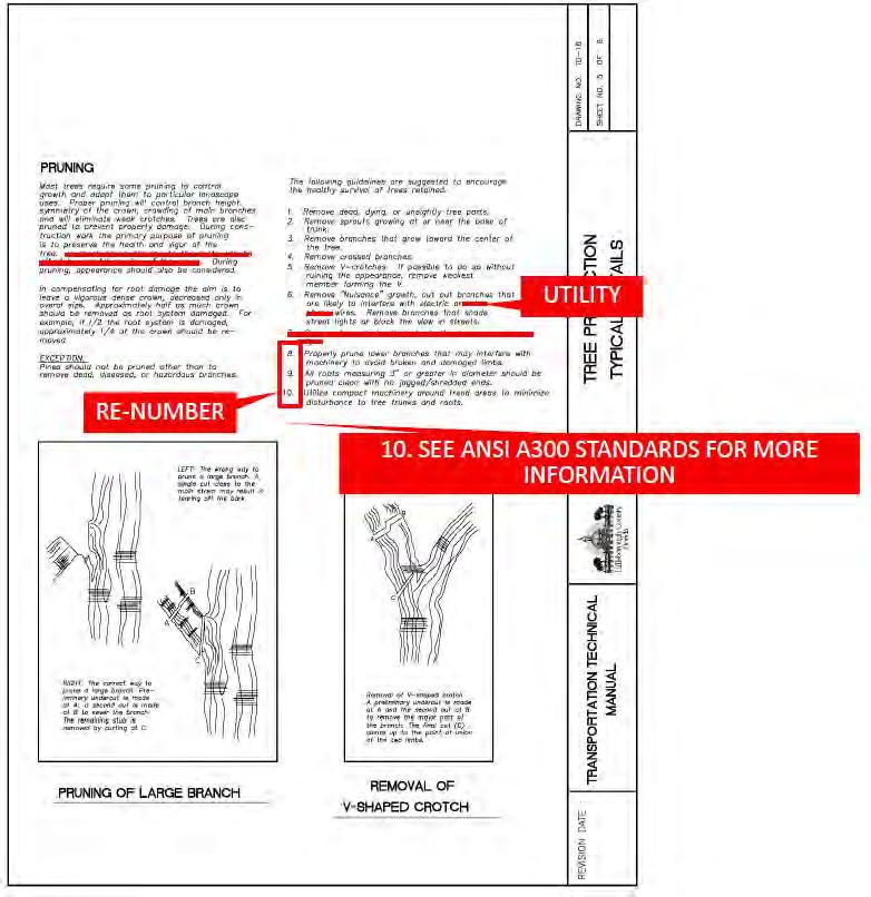
21 Services Division County to update TD-15 (2 of 2) and all TD-16 drawings. Please review the existing details in the TTM against the current FDOT details to confirm that the existing details are still acceptable. FDOT has new Tree protection standard, Index 542, that is not as detailed as currently shown in TTM. 64 Website Submittal TD-16

22 Services Division
23 Services Division 65 County Staff TD-18 Recommend not allowing inlet s to be placed in curb return. County to add Inlet not to be placed in curb return. to note 3 on TD The County may also want to consider integrating references to the new Mobility Fee process into the TTM, where appropriate. This would help clarify the process for the development community. The intent for this manual is to provide design guidance for subdivision and site development projects. No changes are recommended. 67 County Staff 13.0 (New) Hillsborough County has existing roads that are considered substandard with respect to current design criteria for new roadways. New developments impact these roads. At this time these impacts require the roadways be improved to insure safe user operations. Recommend developing a procedure for analyzing substandard roads to insure safe user operations given different constraints and providing guidance on what will be required of developers. County to add new Chapter 13 to address substandard roadways.
Revisions to Larimer County Urban Area Street Standards (2016 Update)
") 1.9.2 B 1-18 Street Construction Policy 1.14 (new) 1-29 Complete Streets in Fort Collins 4.1.1 04-01 General 4.1.3 04-01 Capacity and Safety Issues 4.1.3 B 04-02 Pedestrian Traffic Considerations 4.1.4
1.9.2 B 1-18 Street Construction Policy 1.14 (new) 1-29 Complete Streets in Fort Collins 4.1.1 04-01 General 4.1.3 04-01 Capacity and Safety Issues 4.1.3 B 04-02 Pedestrian Traffic Considerations 4.1.4
CHAPTER 16 PEDESTRIAN FACILITIES DESIGN AND TECHNICAL CRITERIA TABLE OF CONTENTS
 CHAPTER 16 PEDESTRIAN FACILITIES DESIGN AND TECHNICAL CRITERIA TABLE OF CONTENTS Section Title Page 16.1 General... 16-1 16.1.1 AASHTO Reference... 16-1 16.1.2 ADA Requirements... 16-1 16.2 Sidewalks...
This Chapter sets forth the minimum design, technical criteria and specifications to be used in the preparation of all roadway plans.
 4.1 GENERAL This Chapter sets forth the minimum design, technical criteria and specifications to be used in the preparation of all roadway plans. These Roadway Standards are for new construction and modification
Access requests to County streets and roadways are processed through one of the following methods:
 13.1 GENERAL APPLICATION PROCESS Access requests to County streets and roadways are processed through one of the following methods: A. Planned Developments may set general locations for access points.
Roadway Classification Design Standards and Policies. Pueblo, Colorado November, 2004
 Roadway Classification Design Standards and Policies Pueblo, Colorado November, 2004 Table of Contents Page Chapter 1. General Provisions 1.1 Jurisdiction 3 1.2 Purpose and Intent 3 1.3 Modification 3
APPENDIX A: Complete Streets Checklist DRAFT NOVEMBER 2016
 APPENDIX A: Complete Streets Checklist DRAFT NOVEMBER 2016 Complete Streets Checklist MetroPlan Orlando s Complete Streets Checklist is an internal planning tool for staff to further implementation of
Town of Mooresville, North Carolina Neighborhood Traffic Calming and Control Device Policy
 Town of Mooresville, North Carolina Neighborhood Traffic Calming and Control Device Policy Adopted January 6, 2014 Town of Mooresville Development Services Department TOWN OF MOORESVILLE NEIGHBORHOOD TRAFFIC
Multimodal Design Guidance. October 23, 2018 ITE Fall Meeting
 Multimodal Design Guidance October 23, 2018 ITE Fall Meeting Introductions Jessica Wilson TDOT Multimodal Division Office of Multimodal Planning Program Supervisor Jessica.L.Wilson@tn.gov Ali Hangul TDOT
SECTION 3 STREET DESIGN
 3.01 GENERAL SECTION 3 STREET DESIGN For purposes of geometric and structural design, streets shall be classified according to the following table. The City Engineer will determine the class of all proposed
Driveway Design Criteria
 Design Manual Chapter 5 - Roadway Design 5L - Access Management 5L-4 Driveway Design Criteria A. General For efficient and safe operations, access drives and minor public street intersections can be improved
South Carolina Department of Transportation. Engineering Directive
 South Carolina Department of Transportation Engineering Directive Directive Number: ED-22 Effective: December 16, 2009 Subject: References: Purpose: This Directive Applies to: Considerations for Bicycle
Appendix 3 Roadway and Bike/Ped Design Standards
 Appendix 3 Roadway and Bike/Ped Design Standards OTO Transportation Plan 2040 4/20/2017 Page A3-1 Adopted Standards The adopted OTO Design Standards and Major Thoroughfare Plan are contained herein.
Roadway Design Manual
 Roadway Design Manual Manual Notice Archive by Texas Department of Transportation (512) 302-2453 all rights reserved Manual Notice 2009-1 From: Manual: Mark A. Marek, P.E Roadway Design Manual Effective
West Dimond Blvd Upgrade Jodhpur Street to Sand Lake Road
 West Dimond Blvd Jodhpur St to Sand Lake CSS Transportation Project Summary Municipality of Anchorage Project # 05 005 Project Manager: John Smith, P.E. (MOA PM&E) Project Administrator: Julie Makela,
Chapter 2: Standards for Access, Non-Motorized, and Transit
 Standards for Access, Non-Motorized, and Transit Chapter 2: Standards for Access, Non-Motorized, and Transit The Washtenaw County Access Management Plan was developed based on the analysis of existing
APPENDIX L: COST ESTIMATING TOOLS
 APPENDIX L: COST ESTIMATING TOOLS Rural Arterial From LRE MOT * Mobilization * Subtotal Scope Contingency (25%) Total PE Design (15%) CEI (15%) Total Project ** New (2-Lane Roadway) with 5' Paved Shoulders
Public Information Meeting. Orange Camp Road. Dr. Martin Luther King Jr. Beltway to I-4. Presented by: Volusia County August 2, 2018
 Public Information Meeting Orange Camp Road Dr. Martin Luther King Jr. Beltway to I-4 Presented by: Volusia County August 2, 2018 1 Project Goals To improve the operations and safety for Orange Camp Road
Geometric Design Tables
 Design Manual Chapter 5 - Roadway Design 5C - Geometric Design Criteria 5C-1 Geometric Design Tables A. General The following sections present two sets of design criteria tables - Preferred Roadway Elements
County of Greenville South Carolina. Traffic Calming Program Neighborhood Traffic Education Program and Speed Hump Program
 County of Greenville South Carolina Traffic Calming Program Neighborhood Traffic Education Program and Speed Hump Program (rev) August 2008 I. PURPOSE The potential negative impacts from vehicular traffic
Street Paving and Sidewalk Policy
 City Commission Policy 600 Street Paving and Sidewalk Policy DEPARTMENT: Public Works DATE ADOPTED: June 7, 1995 DATE OF LAST REVISION: December 10, 2014 Policy No. 600.01 AUTHORITY: PASS City of Tallahassee-Leon
GEOMETRIC DESIGN STANDARDS FOR NEW RESIDENTIAL SUBDIVISION STREETS TABLE 1A CG-6 CURB AND GUTTER SECTION
 TABLE 1A CG-6 CURB AND GUTTER SECTION HORIZONTAL AND VERTICAL CONTROLS CURB AND GUTTER ROADWAYS MAXIMUM 3:1 CUT OR FILL SLOPE CURVE DATA MIN. SIGHT DISTANCE PROJECTED TRAFFIC VOLUME (ADT) MIN. DESIGN SPEED
Access Management in the Vicinity of Intersections
 Access Management in the Vicinity of Intersections FHWA-SA-10-002 Technical Summary Photo: Ralph Bentley (used with permission) 0 Access Management is: The design, implementation and management of entry
MAG Town of Cave Creek Bike Study Task 6 Executive Summary and Regional Significance Report
 Page 1 MAG Town of Cave Creek Bike Study Task 6 Executive Summary and Regional Significance Report August 1, 2012 MAG Project #481 Page 2 Task 6 Executive Summary and Regional Significance Report Introduction
SECTION 14: LANDSCAPING AND BEAUTIFICATION
 SECTION 14: LANDSCAPING AND BEAUTIFICATION RULE 14.1 GENERAL PROVISIONS 14.1.1 The rules and guidelines contained in this section have been established to provide proper guidelines for the beautification
City of Elizabeth City Neighborhood Traffic Calming Policy and Guidelines
 City of Elizabeth City Neighborhood Traffic Calming Policy and Guidelines I. Purpose: The City of Elizabeth City is committed to ensure the overall safety and livability of residential neighborhoods. One
INDEX. Geometric Design Guide for Canadian Roads INDEX
 Acceleration lane, see Lanes, Acceleration Access, 8.1 Access Management and Functional Classification 8.2 Access Management by Design Classification 8.3 Access Configuration 8.4 Building Set-Back Guidelines
Complete Streets. Designing Streets for Everyone. Sarnia
 Complete Streets Designing Streets for Everyone Sarnia Complete Streets ~ Sarnia ~ 2018 Introduction Our City is made up of a network of streets that we use to go for a walk, cycle to work, drive to the
WYDOT DESIGN GUIDES. Guide for. NHS Arterial (Non-Interstate)
") WYDOT DESIGN GUIDES Guide for NHS Arterial (Non-Interstate) 2014 GUIDE FOR NATIONAL HIGHWAY SYSTEM (NHS) HIGHWAYS (NHS ARTERIALS, Non-Interstate) PRESERVATION REHABILITATION RECONSTRUCTION INTRODUCTION
WYDOT DESIGN GUIDES Guide for NHS Arterial (Non-Interstate) 2014 GUIDE FOR NATIONAL HIGHWAY SYSTEM (NHS) HIGHWAYS (NHS ARTERIALS, Non-Interstate) PRESERVATION REHABILITATION RECONSTRUCTION INTRODUCTION
Access Location, Spacing, Turn Lanes, and Medians
 Design Manual Chapter 5 - Roadway Design 5L - Access Management 5L-3 Access Location, Spacing, Turn Lanes, and Medians This section addresses access location, spacing, turn lane and median needs, including
10.0 CURB EXTENSIONS GUIDELINE
 10.0 CURB EXTENSIONS GUIDELINE Road Engineering Design Guidelines Version 1.0 March 2017 City of Toronto, Transportation Services City of Toronto Page 0 Background In early 2014, Transportation Services
WYDOT DESIGN GUIDES. Guide for. Non-NHS State Highways
 WYDOT DESIGN GUIDES Guide for Non-NHS State Highways 2014 GUIDE FOR Non-NATIONAL HIGHWAY SYSTEM (Non-NHS) STATE HIGHWAYS PRESERVATION REHABILITATION RECONSTRUCTION INTRODUCTION This Guide is directed to
Long Island Rail Road Expansion Project Floral Park to Hicksville
 Long Island Rail Road Expansion Project Floral Park to Hicksville Final Environmental Impact Statement Appendix 1-D Complete Streets Policy Checklist April 2017 0902ML PIN: Project Location: 18A-4 Floral
Off-road Trails. Guidance
 Off-road Trails Off-road trails are shared use paths located on an independent alignment that provide two-way travel for people walking, bicycling, and other non-motorized users. Trails specifically along
CHAPTER 3A. GENERAL PAGE CHAPTER 3B. PAVEMENT AND CURB MARKINGS PAGE
 Virginia Supplement to the 2009 MUTCD Revision 1 Page TC-3-1 PART 3. MARKINGS CHAPTER 3A. GENERAL PAGE Section 3A.01 Functions and Limitations Section 3A.02 Standardization of Application Section 3A.03
Route 47 (North Main Street) Reconstruction
 Reconstruction") TOWN OF SUNDERLAND Route 47 (North Main Street) Reconstruction Presented by Lou Rabito, P.E. Presented to Town of Sunderland June 11, 2018 Project Overview MassDOT Project No. 607245 Resurfacing and Related
TOWN OF SUNDERLAND Route 47 (North Main Street) Reconstruction Presented by Lou Rabito, P.E. Presented to Town of Sunderland June 11, 2018 Project Overview MassDOT Project No. 607245 Resurfacing and Related
City of Margate, Florida. Neighborhood Traffic Management Manual
 City of Margate, Florida Neighborhood Traffic Management Manual Table of Contents Page No. I. INTRODUCTION... 1 II. TRAFFIC CALMING REQUEST AND PROCESSING PROCEDURES... 2 1. COMPLETE AND SUBMIT PROJECT
REGIONAL BICYCLE AND PEDESTRIAN DESIGN GUIDELINES
 REGIONAL BICYCLE AND PEDESTRIAN DESIGN GUIDELINES November 16, 2011 Deb Humphreys North Central Texas Council of Governments Bicycle and Pedestrian Advisory Committee Snapshot of the Guide 1. Introduction
Complete Streets Policy DAVID CRONIN, P.E., CITY ENGINEER
 Complete Streets Policy DAVID CRONIN, P.E., CITY ENGINEER Complete Streets City Commission adopted a Complete Streets policy in 2012 Complete Streets are road networks that are designed for all users:
Gordon Proctor Director Policy on Accommodating Bicycle and Pedestrian Travel on ODOT Owned or Maintained Facilities
 Approved: Policy: 20-004(P) Responsible Office: Planning Gordon Proctor Director Policy on Accommodating Bicycle and Pedestrian Travel on ODOT Owned or Maintained Facilities I. POLICY STATEMENT: This policy
Living Streets Policy
 Living Streets Policy Introduction Living streets balance the needs of motorists, bicyclists, pedestrians and transit riders in ways that promote safety and convenience, enhance community identity, create
Hennepin County Pedestrian Plan Public Comment Report
 Hennepin County Pedestrian Plan Public Comment Report On May 31, 2013, the draft Hennepin County Pedestrian Plan was released for a 45-day public comment period ending July 15, 2013. The county received
TRAFFIC STUDY GUIDELINES Clarksville Street Department
 TRAFFIC STUDY GUIDELINES Clarksville Street Department 9/1/2009 Introduction Traffic studies are used to help the city determine potential impacts to the operation of the surrounding roadway network. Two
Access Management Regulations and Standards
 Access Management Regulations and Standards Efficient highway operation Reasonable property access Concept of Access Management The way to manage access to land development while simultaneously preserving
Access Management Regulations and Standards
 Access Management Regulations and Standards January 2014 Efficient highway operation Reasonable property access Concept of Access Management The way to manage access to land development while preserving
Road Diets: Reconfiguring Streets for Multi-Modal Travel
 Road Diets: Reconfiguring Streets for Multi-Modal Travel Tom Grant, P.E., PTOE What is a Road Diet? Reconfiguration of travel lanes to benefit all roadway users (i.e., Complete Street) Reclaiming the space
PUBLIC WORKS DEPARTMENT SIGN AND MARKING PROCEDURES AND GUIDELINES
 PUBLIC WORKS DEPARTMENT SIGN AND MARKING PROCEDURES AND GUIDELINES 2015 FORWARD The Revised Code of Washington (RCW) 47.36, Traffic Control Devices, requires the Washington State Department of Transportation
City of Roseville Section 13 Design Standards. _Bikeways January 2016 SECTION 13 BIKEWAYS
 SECTION 13 BIKEWAYS 13-1 GENERAL The City of Roseville bikeway standards are designed to insure that transportation and recreational bikeways are constructed in a manner that would provide a safe and comfortable
Prince George s County plans, policies, and projects
 Prince George s County plans, policies, and projects Over 250 projects for trails, bikeways, designated bike lanes and sidewalk construction Trail projects that improve access to Metro Sidewalk and trail
5 CIRCULATION AND STREET DESIGN
 5 CIRCULATION AND STREET DESIGN This chapter describes circulation and streetscape improvements proposed for the Northwest Chico Specific Plan Area. It includes detailed design specifications for existing
Transportation Planning Division
 Transportation Planning Division Presentation Outline Study Tasks Recap of Previous Meetings Data Collected Focus Areas within Study Limits Design Principles Tool Box Recommended Concepts Schedule Moving
Central Arkansas Regional Transportation Study Area ROADWAY DESIGN STANDARDS And Implementation Procedures
 Central Arkansas Regional Transportation Study Area ROADWAY DESIGN STANDARDS And Implementation Procedures These standards have been prepared for the use of all jurisdictions to incorporate into their
November 2012: The following Traffic and Safety Notes were revised:
 CHANGE LIST for MDOT Traffic and Safety, TRAFFIC AND SAFETY NOTES Located at http://mdotcf.state.mi.us/public/tands/plans.cfm JANUARY 2014: The following Traffic and Safety Note was added: Note 705A Angled
DRAFT - CITY OF MEDFORD TRANSPORTATION SYSTEM PLAN Roadway Cross-Sections
 Roadway Cross-Sections Medford s roadway cross-section standards apply to new and reconstructed roads. The crosssections take into consideration roadway function and operational characteristics, including
Proposed. City of Grand Junction Complete Streets Policy. Exhibit 10
 Proposed City of Grand Junction Complete Streets Policy Exhibit 10 1 City of Grand Junction Complete Streets Policy Vision: The Complete Streets Vision is to develop a safe, efficient, and reliable travel
TOWN OF PORTLAND, CONNECTICUT COMPLETE STREETS POLICY
 TOWN OF PORTLAND, CONNECTICUT COMPLETE STREETS POLICY I. VISION, GOALS & PRINCIPLES VISION To improve the streets of Portland making them safer and more accessible for all users including pedestrians,
Construction Specifications Manual
 Isle of Wight County Pedestrian and Bicycle Master Plan Construction Specifications Manual Adopted August 20, 2009 Introduction The Isle of Wight County Pedestrian and Bicycle Facilities Master Plan was
Plant City Walk-Bike Plan
 Plant City Walk-Bike Plan Plant City Commute Mode Share 2.2% 1.4% 2.9% Drove alone 10.2% Carpooled Public transportation (0.1%) Walked Used a Bike (0.4%) 82.9% Taxicab, motorcycle, or other means Worked
CONNECTIVITY PLAN. Adopted December 5, 2017 City of Virginia Beach
 CONNECTIVITY PLAN Adopted December 5, 2017 City of Virginia Beach CONTENTS 1.0 Background & Purpose... 2 2.0 Existing Inventory & Analysis... 3 ViBe District Existing Walking Conditions... 4 3.0 ViBe District
APPENDIX G SIGNAGE AND STRIPING SUPPLEMENT
 APPENDIX G SIGNAGE AND STRIPING SUPPLEMENT DOUGLAS COUNTY SIGNAGE AND STRIPING SUPPLEMENT TO DOUGLAS COUNTY ROADWAY DESIGN & CONSTRUCTION STANDARDS UPDATED MAY 2018 TABLE OF CONTENTS 1.00: GENERAL REQUIREMENTS...
5/31/2016 VIA . Arwen Wacht City of Sacramento Community Development Department 300 Richards Blvd., 3 rd Floor Sacramento, CA 95811
 5/31/2016 VIA EMAIL Arwen Wacht City of Sacramento Community Development Department 300 Richards Blvd., 3 rd Floor Sacramento, CA 95811 RE: El Pollo Loco (P16-028) Dear Ms. Wacht: WALKSacramento has reviewed
Recommended Roadway Plan Section 2 - Land Development and Roadway Access
 Recommended Roadway Plan Section 2 - Land Development and Roadway Access SECTION 2 Land Development and Roadway Access 2.1 Land Use and Access Management The Federal Highway Administration (FHWA) defines
NJDOT Complete Streets Checklist
 Background The New Jersey Department of Transportation s Complete Streets Policy promotes a comprehensive, integrated, connected multi-modal network by providing connections to bicycling and walking trip
Roadway Design Manual
 Roadway Design Manual Revised December 2013 2013 by Texas Department of Transportation (512) 302-2453 all rights reserved Manual Notice 2013-1 From: Manual: Mark A. Marek, P.E Roadway Design Manual Effective
RURAL HIGHWAY SHOULDERS THAT ACCOMMODATE BICYCLE AND PEDESTRIAN USE (TxDOT Project ) June 7, Presented by: Karen Dixon, Ph.D., P.E.
 June 7, Presented by: Karen Dixon, Ph.D., P.E.") RURAL HIGHWAY SHOULDERS THAT ACCOMMODATE BICYCLE AND PEDESTRIAN USE (TxDOT Project 0-6840) June 7, 2016 Presented by: Karen Dixon, Ph.D., P.E., TTI Team: Kay Fitzpatrick, Raul Avelar, & Subasish Das Project
RURAL HIGHWAY SHOULDERS THAT ACCOMMODATE BICYCLE AND PEDESTRIAN USE (TxDOT Project 0-6840) June 7, 2016 Presented by: Karen Dixon, Ph.D., P.E., TTI Team: Kay Fitzpatrick, Raul Avelar, & Subasish Das Project
ACTIVE TRANSPORTATION
 ACTIVE TRANSPORTATION Mobility 2040 Supported Goals Improve the availability of transportation options for people and goods. Support travel efficiency measures and system enhancements targeted at congestion
Appendix T CCMP TRAIL TRAFFIC & TRANSPORTATION DESIGN STANDARD
 Appendix T CCMP 3.3.4 TRAIL TRAFFIC & TRANSPORTATION DESIGN STANDARD 3.3.4 Trail Traffic and Transportation Design Multi-use trails have certain design standards, which vary depending on the agency that
Memo. Introduction. Memphis STP Pedestrian Sidewalk Project
 Memo Memphis STP Pedestrian Sidewalk Project To: Kyle Wagenshutz, City of Memphis From: Matthew Berkow, Collin Chesston, and Anne Eshleman, Alta Planning + Design Date: June 2014 Re: Photo Inventory Introduction
APPROVE A RESOLUTION ADOPTING A COMPLETE STREETS POLICY
 STAFF REPORT MEETING DATE: September 13, 2016 TO: FROM: City Council Bob Brown, Community Development Director Russ Thompson, Public Works Director Patrick Filipelli, Management Analyst 922 Machin Avenue
SECTION 1 - TRAFFIC PLANNING
 SECTION 1 - TRAFFIC PLANNING 1.1 TRAFFIC OPERATIONS 1.1.1 Roadway Functional Classification The Multnomah County Comprehensive Framework Plan s Policy 34: Trafficways and the Functional Classification
Classification Criteria
 SCHEDULE D TO RECOMMENDED OFFICIAL PLAN AMENDMENT NO. 40 SCHEDULE C-4 Road Criteria Criteria Traffic Service Objective Land Service/Access Typical Daily Traffic Volume Flow characteristics Travel Speed
INDOT Complete Streets Guideline & Policy
 INDOT Complete Streets Guideline & Policy INTRODUCTION The Complete Streets guidelines build upon multiple efforts and promote a multimodal transportation system that is integrated and sustains land use
CHAPTER 1 GENERAL DESIGN
 CHAPTER 1 GENERAL DESIGN 1.0 INTRODUCTION The purpose of this Manual is to provide its users with the current, uniform procedures and guidelines for the application and design of safe, convenient, efficient
Implementing Complete Streets in Ottawa. Project Delivery Process and Tools Complete Streets Forum 2015 October 1, 2015
 Implementing Complete Streets in Ottawa October 1, 2015 The Essentials Complete Streets Implementation Framework will become part of the routine delivery of City transportation projects Approach uses every
Does It Work? THE BENCHMARKING PROJECT. State Department of Transportation Project Assessment. Bill Wilkinson and Bob Chauncey
 THE BENCHMARKING PROJECT Does It Work? State Department of Transportation Project Assessment Bill Wilkinson and Bob Chauncey National Center for Bicycling & Walking 1506 21 st Street NW, Washington, DC
APPENDIX B(1) SUBDIVISION STREET DESIGN GUIDE. SECTION B(1) 1 INTRODUCTION Introduction... B(1)-1
 SUBDIVISION STREET DESIGN GUIDE. SECTION B(1) 1 INTRODUCTION Introduction... B(1)-1") APPENDIX B(1) SUBDIVISION STREET DESIGN GUIDE SECTION B(1) 1 INTRODUCTION Introduction... B(1)-1 SECTION B(1) 2 DESIGN REQUIREMENTS Projected Traffic / Operational / Capacity Analysis... B(1)-2 Functional
APPENDIX B(1) SUBDIVISION STREET DESIGN GUIDE SECTION B(1) 1 INTRODUCTION Introduction... B(1)-1 SECTION B(1) 2 DESIGN REQUIREMENTS Projected Traffic / Operational / Capacity Analysis... B(1)-2 Functional
City of Albert Lea Policy and Procedure Manual 4.10 ALBERT LEA CROSSWALK POLICY
 4.10 ALBERT LEA CROSSWALK POLICY PURPOSE: Pedestrian crosswalks are an integral part of our transportation infrastructure. To be effective and promote safety, marked crosswalks must be installed after
M-58 HIGHWAY ACCESS MANAGEMENT STUDY Mullen Road to Bel-Ray Boulevard. Prepared for CITY OF BELTON. May 2016
 M-58 HIGHWAY ACCESS MANAGEMENT STUDY Prepared for CITY OF BELTON By May 2016 Introduction Missouri State Highway 58 (M-58 Highway) is a major commercial corridor in the City of Belton. As development has
City of Vallejo Traffic Calming Toolbox
 City of Vallejo Traffic Calming Toolbox June 1, 2013 Final Table of Contents Introduction... 1 Non-Physical Devices... 3 High-Visibility Crosswalk... 3 In Pavement Lighted Crosswalk... 4 Rapid Flashing
County of Spartanburg South Carolina
 County of Spartanburg South Carolina Traffic Calming Program June 2012 (Revised/Program on Hold) PURPOSE The potential negative impacts from vehicular traffic on residential roads have been a longstanding
Road Diets FDOT Process
 Florida Department of TRANSPORTATION Road Diets FDOT Process Humberto Castillero, PE, PTOE Roadway Design Office Purpose of Guide Develop a statewide lane elimination review process Balance state & local
BPP / SUB
 Development Services Department Project/File: Lead Agency: Site address: Millwell Place Subdivision/ BPP15-0031/ SUB15-0064 This is a preliminary plat application to allow for the development of 68 building
Bicyclist Signing Guidelines
 Bicyclist Signing Guidelines April, 2009 1 Introduction This paper describes the Montana Department of Transportation s (MDT) current practices related to bicyclist safety and signing issues and presents
MOVING PASSAIC COUNTY
 MOVING PASSAIC COUNTY COMPLETE STREETS GUIDELINES OCTOBER 2012 Prepared By: Passaic County Department of Planning and Economic Development with assistance from Parsons Brinckerhoff PASSAIC COUNTY COMPLETE
GOAL 2A: ESTABLISH AND MAINTAIN A SAFE, CONVENIENT, AND EFFICIENT MULTI-MODAL TRANSPORTATION SYSTEM TO MOVE PEOPLE AND GOODS THROUGHOUT THE CITY.
 2. TRANSPORTATION ELEMENT The purpose of this element is to assist in establishing an adequate transportation system within the City and to plan for future motorized and non-motorized traffic circulation
TRANSPORTATION STANDARDS
 INTRODUCTION LOCAL STREETS ON-STREET PARKING SIDEWALKS STREET LIGHTING STREET FURNISHINGS TRAFFIC CALMING STREET TREES MEDIAN PLANTING BOULEVARD LOCATIONS VILLAGE CENTER STREET LOCATIONS RESIDENTIAL STREET
Chapter 4 TOOLBOX AND SAMPLE BIKE BOULEVARD LAYOUT
 Chapter 4 TOOLBOX AND SAMPLE BIKE BOULEVARD LAYOUT OVERVIEW This chapter describes a cohesive set of strategies to create a bicycle boulevard, namely to make streets safer and more efficient for bicycle
NEIGHBOURHOOD TRAFFIC COMMITTEE POLICY AND PROCEDURE
 The City of Vaughan 2141 Major Mackenzie Drive Vaughan, Ontario Canada L6A 1T1 Tel (905) 832-2281 NEIGHBOURHOOD TRAFFIC COMMITTEE POLICY AND PROCEDURE REVISED JUNE 2010 APPLICABILITY The Neighbourhood
Brian D. Hare, P.E. Bureau of Design PennDOT PA APA Annual Conference Investing in a Sustainable Future October 5, 2009
 Brian D. Hare, P.E. Bureau of Design PennDOT 2009 PA APA Annual Conference Investing in a Sustainable Future October 5, 2009 1 What is Smart Transportation? Photographer: heyjude. Used through license
Closing Plenary Session
 TRAFFIC SAFETY CONFERENCE Closing Plenary Session June 9, 2017 Las Colinas, TX Order of Report Out June 9, 2017 Las Colinas, TX Distracted Driving Prioritized Countermeasures Countermeasure 4a Systemically
Item to be Addressed Checklist Consideration YES NO N/A Required Description Complete Streets Guidelines
 Passaic County Complete Streets Checklist - Concept Development Project Name Item to be Addressed Checklist Consideration YES NO N/A Required Description Complete Streets Guidelines Existing Plans Have
5. RUNNINGWAY GUIDELINES
 5. RUNNINGWAY GUIDELINES These guidelines should be considered collectively when making runningway decisions. A runningway is the linear component of the transit system that forms the right-of-way reserved
City of Saline. Complete Streets Ordinance
 City of Saline Complete Streets Ordinance September 13 and 20, 2010 CARLISLE/WORTMAN ASSOCIATES What Are Complete Streets? Complete streets are designed to serve everyonemotorists as well as pedestrians
This page intentionally left blank.
 This page intentionally left blank. COMMUNITY Coweta Community Overview Coweta Coweta, a residential community located in Wagoner County, is a suburb of Tulsa situated southeast of the metropolitan area
On Road Bikeways Part 1: Bicycle Lane Design
 On Road Bikeways Part 1: Bicycle Lane Design Presentation by: Nick Jackson Bill Schultheiss, P.E. September 04, 2012 FOLLOW THE CONVERSATION ON TWITTER Toole Design Group is live tweeting this webinar
Inspector MUST Sign and Date Each Inspection
 Work Area: Applicant: Mercer County Department of Transportation - Highways Division Application and Permit for Road Work in Mercer County, New Jersey NO. East Windsor Ewing Hamilton Hopewell Lawrence
Who is Toole Design Group?
 2018 AASHTO Bike Guide Status Update NCHRP 15 60 Amalia Leighton Cody, PE, AICP & Kenneth Loen, PE Washington APWA October 4, 2018 Who is Toole Design Group? TDG is a full service engineering, planning
Chapter 6: Along the Street
 Chapter 6: Along the Street This section describes the types of infrastructure that should be in place along school routes to make walking and bicycling to school safer. Sidewalks In communities with sidewalks,
Active Transportation Facility Glossary
 Active Transportation Facility Glossary This document defines different active transportation facilities and suggests appropriate corridor types. Click on a facility type to jump to its definition. Bike
Fleur Drive Reconstruction
 Fleur Drive Reconstruction October 29, 2018 1 Agenda: Fleur Drive Reconstruction Project Scope & Cost Overview Fleur Drive Cross Section Elements - Travel Lane Widths - Sidewalk Widths - Parkway Widths
Overview. Illinois Bike Summit IDOT Complete Streets Policy Presentation. What is a Complete Street? And why build them? And why build them?
 Overview Illinois Bike Summit IDOT Complete Streets Policy Presentation Aren Kriks, P.E. District One Bicycle Coordinator and Bureau of Programming Project Engineer History of Complete Streets IDOT Policy