Curb Versus Median Bus Lanes: The Yonge Street Case Study
|
|
|
- Gabriel Peters
- 5 years ago
- Views:
Transcription
1 Curb Versus Median Bus Lanes: The Yonge Street Case Study Andrew Shea, McCormick Rankin Corporation Dale Turvey, McCormick Rankin Corporation (Presenter) Paper prepared for presentation at the Transit/Transportation Corridors Without Boundaries Session 2006 Annual TAC Conference Charlottetown, Prince Edward Island
2 ABSTRACT The City of Toronto is placing a greater emphasis and priority on the development of higher-order public transit operations to respond to increased travel demand in a sustainable fashion. This study is focused on addressing the short-term ten-year needs within the Yonge Street corridor, recognizing the adopted long-term proposal to extend the Yonge Subway. Although extension of the Yonge Subway is in the City of Toronto s long-term plan, the TTC has identified other corridors as priorities for subway extensions. Over the next ten years, significant growth in population north of Steeles Avenue is expected. In order to identify surface transit opportunities for improvements on Yonge Street between Steeles Avenue and Finch Avenue, the City of Toronto, together with the TTC and GO Transit have initiated a Class Environmental Assessment, which is being carried out according to Schedule C. The impact assessment recognized that the preferred alternative should allow for the integration of transit services with the proposed Yonge Street Transitway north of Steeles avenue by York Region. The Study, at the time of writing this paper, has not concluded which approach to implementing surface transit improvements will be used. This paper focuses on the constraints, analyses, and trade-offs between competing objectives that occurred during the development of design concepts, and identify practical lessons and generic conclusions that can be applied to similar studies. The initial screening process of assessment factors revealed that the design alternatives exhibit significant differences in the following assessment factors: - transit system performance; - disruption of present land use development; - traffic infiltration into the adjacent residential neighbourhoods; - traffic delay; - road safety; - access to adjacent businesses; - fire, police and emergency services access; and - construction cost The procedures applied to quantify the implications of alternative design concepts appear to have been successful in providing reasonable estimates of the potential impacts and communicating these potential impacts in meaningful terms to the various stakeholders. 1
3 1.0 INTRODUCTION Study Background and Purpose The City of Toronto is placing a greater emphasis and priority on the development of higher-order public transit operations to respond to increased travel demand in a sustainable fashion. The Yonge Street corridor from south of Steeles Avenue to Finch Avenue has been identified as a high priority to enhance the attractiveness of public transit by a number of municipal and provincial agencies, including the Central Ontario Smart Growth Panel, the Toronto Transit Commission (TTC), the Greater Toronto Services Board (GTSB), GO Transit and York Region. The City s recently adopted Official Plan places major emphasis on increasing transit ridership and Council has determined improved transit operations need to be examined both to potentially alleviate current conditions but also to respond to the forecast growth in demand. This study is focused on addressing the short-term ten-year needs within the corridor recognizing the adopted long-term proposal to extend the Yonge Subway. Although extension of the Yonge Subway is in the City of Toronto s long-term plan, the TTC has identified other corridors as priorities for subway extensions. Over the next ten years, significant population growth north of Steeles Avenue is expected. In order to identify surface transit opportunities for improvements on Yonge Street between Steeles Avenue and Finch Avenue, the City of Toronto, together with the TTC and GO Transit have initiated a Municipal Class Environmental Assessment, which is being carried out according to Schedule C. The impact assessment recognized that the preferred alternative should allow for the integration of transit services with the proposed Yonge Street Transitway north of Steeles Avenue by York Region. The Study, at the time of writing this paper, has not concluded which approach to implementing surface transit improvements will be used. This paper will rather focus on the constraints, analyses, and trade-offs between competing objectives that occurred during the development of design concepts, and identify practical lessons and generic conclusions that can be applied to similar studies. Present Corridor Conditions Within the Study Area (illustrated in Figure 1), Yonge Street is a 7-lane road comprised of three lanes in each direction plus a median two-way left-turn lane. Sidewalks and paved boulevards are provided on each side of the road. All of these features are provided within a 33m right-of-way. The curb lanes operate as High Occupancy Vehicle (HOV 3+) lanes in peak hours. The HOV lanes were implemented in 1993 to increase the person-trip capacity of the roadway while improving transit operations. For the most part, the initiative has proven effective. 2
4 Local, or all-stop, buses operate in the curb HOV lanes in peak hours allowing them to bypass some congestion and serve passengers at curbside stops. However, operations in the curb HOV lanes can, at times, be hampered by the inherent conflicts with rightturning vehicles accessing the many private establishments fronting onto Yonge Street. Express buses tend to operate in the mixed traffic lanes to avoid delays caused by local buses stopping to serve passengers and allow an easier transition into the northbound leftturn lane at Steeles Avenue and the southbound left-turn lane at Bishop Avenue. Local buses typically experience difficulty in accessing the left-turn lanes at these points due to the need to cross over two lanes of congested traffic in peak periods. A number of transit routes are operated by the Toronto Transit Commission (TTC), GO Transit, York Region Transit (YRT), and Brampton Transit (BT) within the Yonge Street corridor. The TTC operates a number of regular transit routes on Yonge Street, Bathurst Street, Finch Avenue, Steeles Avenue, Cummer Avenue, Moore Park Avenue and Hilda Avenue. Many of these bus routes connect with the northern terminus of the Yonge Subway line at the Finch station. This terminal acts as a major transfer point, particularly for north-south commuters, providing a connection between bus and subway operations. Two commuter parking lots are located within the adjacent Hydro Electric Power Corridor (HEPC) providing a total of 2,900 parking spaces as well as a passenger pickup/drop-off facility. GO Transit and York Region Transit also operate buses on Yonge Street. These buses originate in York Region and travel north-south via Bathurst Street, Yonge Street, and Bayview Avenue to Steeles Avenue. South of Steeles Avenue, all GO Transit and YRT buses operate on Yonge Street. The GO Finch Bus Terminal is located on the east side of Yonge Street, north of Bishop Avenue adjacent to the TTC Finch Subway station. In total, 117 buses are operated southbound during the AM peak hour on Yonge Street carrying approximately 3,000 passengers to the TTC Finch Subway station, and 1,500 passengers to the GO Finch Bus Terminal. During the AM peak hour, 57% of the approximately 7,900 southbound person trips use transit. Future residential and commercial development forecasts indicate that the demand in the corridor from the north will reach levels of approximately 17,200 in the AM peak hour, to be shared between Bathurst Street, Yonge Street, and Bayview Avenue and the intermediate collector/local roadways. The existing roadway network provides a capacity of approximately 9,600 person-trips per hour, per direction. If transit mode-share remains as is today, the resulting roadway capacity deficiency of 1,100 person-trips per hour, per direction is expected. Problem Statement Based on the analysis of existing conditions and future transportation deficiencies, transportation solutions are necessary to improve current transit operations along Yonge Street between Steeles Avenue and Finch Avenue and address projected capacity deficiencies in the Yonge Street corridor by
5 2.0 DEVELOPMENT OF ALTERNATIVE DESIGN CONCEPTS The development of a wide range of alternative design concepts reflected the input of members of the public and technical advisory staff. Early concepts included operational changes such as one-way conversion of Yonge Street, reversible lanes, and physical changes such as roadway widening, curb Reserved Bus Lanes (RBLs), median RBLs and contraflow RBLs. A preliminary screening of these preliminary options was conducted based on their operational benefits and drawbacks. It was determined that one-way conversion of Yonge Street through the study area would be operationally infeasible due to the two-way operation of segments upstream and downstream of the study area. Roadway widening was considered to be extremely expensive due to property requirements, and too disruptive to the established businesses and residents in the corridor. Barrier-separated curb RBLs were discarded, as they would have a significant impact on adjacent businesses. The guided median RBL concept was eliminated from further consideration due to the barrier effect on emergency vehicle access. Through the preliminary screening process, the curb and median RBL design concepts appeared to offer the greatest potential to address the transportation requirements while minimizing the negative impacts to the community. Selected Design Concepts Curb Reserved Bus Lanes Given that Yonge Street currently features curb HOV lanes within the Study Area, the change to full Reserved Bus Lanes (RBLs) would largely be an operational change, with minor physical modifications to address location-specific issues. The existing curb lanes would be re-painted and re-signed to full RBLs 24-hours a day, 7- days a week. Although this would displace users of the HOV lanes in peak hours estimates indicate that there are approximately 400 vehicles operating in the curb lanes during the peak hour (including legitimate HOVs, taxis, buses, and violators) which would be redistributed to the other two general traffic lanes or to alternative routes. The potential impact of the reassignment of this traffic was not considered sufficient to preclude consideration of this concept. In order for Curb RBLs to function effectively, they need to be able to accommodate both all-stops and express bus services. Curbside bus bays would therefore be introduced to allow all-stops buses to serve passengers outside of the stream of express buses, thereby minimizing the delays to express buses and avoiding forcing them to move into the general purpose lanes. The Curb RBL concept is not a pure Curb RBL operation, as median reserved bus lanes would be provided northbound at Steeles Avenue and southbound at Bishop Avenue to facilitate the left-turning movements of transit vehicles through these congested intersections. 4
6 The curb lane, although intended for use only by transit vehicles, would allow for general traffic use strictly for those vehicles making right turns into private accesses or at crossing streets. Toronto s current by-law allows these vehicles to enter the curb lane within 50m in advance of their turn. At key intersections, notably those with heavy rightturning movements, additional right-turn lanes would be provided to accommodate some queuing right-turning vehicles without delaying the through transit vehicles. This would require that right-turning vehicles cross the stream of buses to enter the right turn lane. This configuration is illustrated in Figure 2. Median Reserved Bus Lanes The Median RBL concept was developed to provide an alternative design concept that would separate buses from general traffic operations to the maximum feasible extent. This concept would see the median two-way left-turn lane replaced by a raised median, adjacent to which would be placed reserved bus lanes. This configuration is illustrated in Figure 3. Similar to many streetcar lines (Spadina Avenue or Queen s Quay, for example) in the City of Toronto, this concept would require the construction of median island stops/platforms to allow passengers to wait safely within the roadway to access bus services operating in the median. Again, the existing curb HOV lanes would be reassigned to the general traffic lanes. By relocating bus operations to the median of the roadway, the access/egress movements to and from private establishments fronting onto Yonge Street, would not impact transit operations. Left-turn movements for general traffic across the facility would be physically restricted by the centre boulevard at all locations except signalized intersections. 3.0 APPROACH TO IMPACT ASSESSMENT ANALYSIS Identification of Assessment Factors The approach taken to identify key issues for the study involved a number of sources. These included public consultation, agency contacts, recent similar investigations within the City of Toronto, and the relevant experience of the consultant. Early in the study, a Public Information Centre was held, allowing potentially affected residents, business owners, and commuters the opportunity to provide input into the study regarding the analysis, development and selection of a preferred solution, as well as voice concerns regarding changes that may occur in the study area. This public consultation process formed a valuable method for gathering information and identifying potential areas for improvement to the transportation network in the study area, and formed a vital component in establishing comparison factors and determining the significance of impacts of alternative design concepts. 5
7 City and other technical advisory staff provided input throughout the study process. The technical advisory staff provided expertise and guidance in all aspects of public transportation, traffic operations, pedestrian and cyclist environment, and urban planning as they relate to the study. The City of Toronto has carried out similar studies in recent years for the development of median Light Rail Transit (LRT) facilities, most notably the Spadina Streetcar line and the St. Clair West Streetcar line. Both of these studies examined the impacts of developing a median transit facility in a fully developed urban arterial corridor, and thus provided a background in the potential impacts that could result from the construction of a median facility on Yonge Street. McCormick Rankin Corporation (MRC) has been involved in Bus Rapid Transit projects in Canada, the United States, Australia, New Zealand, and in the United Kingdom. These projects have included a variety of situations, both in exclusive rights-of-way and on arterial streets, and in rural and urban settings. These previous studies provided an extensive knowledge base and experience applicable to this investigation. The Key Issues The initial screening process of assessment factors indicated that the decision-making process must address the impacts of the design concepts under the following assessment factors: transit system performance; disruption of present land use development; traffic infiltration into the adjacent residential neighbourhoods; traffic delay; road safety; access to adjacent businesses; fire, police and emergency services access; and construction cost The impact assessment procedures applied in quantifying these factors are highlighted in the remainder of this paper. 6
8 4.0 SUMMARY OF IMPACT ASSESSMENT OF ALTERNATIVE DESIGN CONCEPTS The preliminary impact assessment examined the broad range of assessment factors. These included impacts to the transportation network, social environment and City policies, economic environment, natural environment, and costs. Each of these broad factors was comprised of a series of sub-factors, resulting in a total number of 30 assessment factors. Each design concept was assessed under each criterion to determine the magnitude of the impact, the incidence of the impact and the significance of the impact. The impact assessment procedure allowed the Project Team to screen out those factors that exhibited similar impacts under all alternatives and therefore did not provide a basis for selecting a preferred concept or impacts that were not considered significant. This screening process then resulted in a comparison of only those factors that exhibited significant and varying impacts between design alternatives, thereby streamlining and clarifying the assessment procedure. Transit System Performance The existing transit travel times, based on average travel times collected during site surveys, have shown that transit trips throughout the corridor can vary within a range of approximately +/- 3 minutes. This is due to localized queuing for turning movements at both the Steeles Avenue intersection and the Bishop Avenue intersection. Queuing in these areas can affect both northbound and southbound buses, and result in an overall reduction in transit service reliability. The Yonge Street Corridor was analyzed using micro-simulation modelling software (VISUM/VISSIM) and reflected the anticipated dynamics of the traffic conditions during the AM peak period (6AM-9AM). This model was quite extensive, covering an area of approximately 20 km 2, and included the future North York Service Road a ring road covering the southern half of the study area and beyond, designed to enhance access to developments along the Yonge Street corridor. The base-case model was validated according to observed travel times between Steeles Avenue and Finch Avenue/TTC Finch Terminal/GO Finch Bus Terminal in order to establish a basis to assess future transit operations and the impact on the general traffic. Following validation of the base-case model, the existing configuration, Curb, and the selected design concepts were input and simulated for a future scenario, using forecast traffic volumes for a horizon year of Future traffic volumes were established based on a VISUM travel demand model developed by McCormick Rankin Corporation, and validated against the City of Toronto s EMME/2 travel demand model for the 2011 AM peak period scenario. This allowed the impacts of these alternative facility concepts to be compared against the future scenario without any improvements. 7
9 The results identified opportunities to provide localized improvements to the design concepts to address areas of concern. Given the number of traffic signals in the corridor (7), the length of the study area (2 km), and the peak hour traffic volumes (approximately 2,900 vehicles during the peak hour in the peak direction, 2003) to compete with, it is expected that the travel time savings under either alternative would be minimal somewhere in the order of seconds per trip. Under a curb RBL alternative, by not ultimately separating transit operations from general traffic operations general traffic could legitimately use the lane to access private establishments and crossing streets the uncertainty of arrival times currently experienced in the HOV lanes would remain. Implementation of a Curb RBL would not address the issue of delays caused by queuing at both Steeles Avenue and Bishop Avenue as transit vehicles would be required to enter the general purpose lanes to access left-turn lanes at these specific intersections. Overall, the Curb RBL concept would have a marginal increase in the current transit system operating capacity. The median RBL option which minimizes conflicts with general traffic provides predictable and reliable travel times through the corridor. This plays a significant role in attracting ridership surveys have shown that one of the key factors affecting a person s decision to use public transit is (along with travel time) the reliability of the transit service (Source: TTC Building a Transit City, 2005). Importantly, the introduction of a Median RBL concept would have a significant impact on transit system capacity; upwards of 50%. Traffic Infiltration In Adjacent Residential Neighbourhoods The transportation analysis, conducted using the expanded VISSIM micro-simulation model, was focussed on the level-of-service implications for general area traffic patterns, with particular attention being paid to the possible diversion of traffic away from Yonge Street and other arterial roads to collector and local streets. The impact of the alternative design concepts with respect to forced relocation of turning movements and access to adjacent businesses is addressed elsewhere in this paper. The 24-hour travel demand data was examined to isolate the through and destined trips within the corridor based on the estimated zonal trip interchanges. The destined trips were then examined by trip purpose to identify the magnitude of trips destined within the adjacent residential neighbourhoods and the employment/shopping/ personal business trips with an origin/destination to the development fronting on Yonge Street. These estimates were compared with the current traffic volumes along the arterial and collector street network through the use of the micro simulation model. The degree of the traffic diversion was inferred through an analysis of traffic patterns on the local street network. On the basis of the forecast intensification of development combined with the future level of service provided, the magnitude of the diversion of through vehicle trips from Yonge Street was predicted. 8
10 Traffic Delay/Level-of-Service Level-of-service may be evaluated in several different ways, depending upon the context. For this analysis, three separate measures were used to assess traffic level of service changes along Yonge Street. Delay-based level-of-service at key intersections. This measure has emerged as a de facto norm for level-of-service analyses, as evidenced by the primary methodologies and outputs of the Highway Capacity Manual (HCM 2000) and the SYNCHRO suite, the most commonly used methodologies today. For this analysis, the macroscopic delay-estimation procedures in HCM 2000 and SYNCHRO were replaced by the microscopically-simulated delays from the VISSIM model. Although delay is a measure that is relatively easily understood by transportation system users, it has several deficiencies as an exclusive performance measure. The key drawback of delay-based level-of-service as a measure is that it does not behave in a linear fashion and therefore provides little indication of how close an intersection is to capacity conditions. Delay increases relatively slowly until capacity levels are approached and exceeded, at which point it increases at higherthan-exponential rates. Other complications involve the role that cycle length plays in determining average delay. With longer cycle lengths, despite the fact that the street may be practically free of traffic, good levels-of-service cannot be achieved. Travel time changes along the corridor. This provided a good overall measure of the ability of vehicular traffic to traverse the corridor. Travel times were assessed using the VISSIM microsimulation software to identify the impacts of implementing a median transit facility on both transit and general traffic travel times between Steeles Avenue and Finch Avenue. Given the minor operational changes involved in converting the curb lanes from HOV to complete Reserved Bus Lanes (RBLs), travel time changes were estimated to be minimal. Volume/capacity ratios at key intersections. To address the shortcomings of delaybased level-of-service as a performance measure, it was considered beneficial to combine it with volume-capacity ratios. This type of analysis enables the identification of how much capacity headroom is available, in a linear fashion, and gives a clearer indication of where an intersection sits with respect to its absolute vehicular capacity. For this analysis, the overall intersection volume/capacity ratio as reported by HCM 2000 was used. Key advantages are that it accounts for all critical (conflicting) lane groups and it is independent of signal timing, requiring only a suitable phasing arrangement to be decided upon. When the levels-of-service for the northbound and southbound (through-traffic only, in this case) approaches to the intersections along Yonge Street are considered, based on micro-simulation, the only truly critical situations across the four scenarios involve the Yonge/Steeles intersection, in particular with respect to the southbound movement. 9
11 In addition, the metering effect of the intersections at the north and south limits of the corridor must be recognized in the assessment of the impacts. The Yonge/Steeles intersection meters southbound traffic entering the portion of the Yonge Street corridor of interest to this study. This metering effect will be increased with implementation of a median transit facility as intersection green-time will be required to accommodate exclusive transit phases. The net result of this metering effect will be significant southbound queues north of Steeles Avenue. Similarly, the Yonge/Avondale intersection meters northbound traffic entering the Yonge Street corridor within the study area. Disruption of Present Land Use Development The Yonge Street corridor imposes many physical constraints on the development of transportation improvements. Properties along Yonge Street and adjacent communities are fully established, leaving little available property for the development of transportation improvements. To a certain degree, these constraints controlled the physical attributes of design concept elements such as: lane widths; stop configurations; intersection configurations; and sidewalk/boulevard treatments. Every effort was made to limit the disruption to present development in the corridor. Measures taken to limit the disruption to existing development included: the removal of the boulevard at bus stops in place of bus bays and at intersections in place of localized widening for additional turning lanes; selecting a minimum lane width of 3.5m for all through lanes; limiting median widths in median RBL design concepts to 3m; limiting sidewalk/boulevard width to a maximum of 4m, and incorporating streetscaping elements with limited width requirements; and the removal of 1.5m curb cycle lanes from early design concepts an analysis of cyclist level-of-service determined that, under either a Curb or Median RBL facility, installation of 1.5m wide standard curb cycle lanes would not provide a significant improvement to cyclist comfort in the corridor. Through these measures, the impact of the design concepts was minimized in an absolute and relative sense. The impacts of either a curb RBL facility or a median RBL facility were determined to be approximately equal. However, as the property impacts of the alternatives are situated in different locations, the Median RBL facility would result in the elimination of approximately 350 private parking spaces throughout the corridor. The Curb RBL design concept would affect approximately 270 private parking spaces. Given that the corridor contains in the order of 6400 private parking spaces, the impact of these alternatives (of approximately 5%) was not considered significant. However, by looking 10
12 at each property individually it became evident that some businesses with limited parking may experience significant impacts, and therefore mitigation measures (such as sidestreet parking) would have to be developed. Road Safety The objectives of the road safety analysis were to examine existing operational and geometric conditions of the study area to establish the factors which contribute to a higher than average collision rate for all modes of transportation, including pedestrians and cyclists, and to identify what, if any, impacts the alternative design concepts would have on the collision rates. Given that the Curb RBL alternative would result in no significant operational change, it was determined that it would have little impact on the corridor s collision rates. To determine the impacts of the Median RBL alternative, collision experience from a similar recent study was drawn upon for guidance. Collision experience on Spadina Avenue was reviewed for a period of three years prior to and following the construction of a median Light Rail Transit (LRT) system. The effects of implementing this type of facility on Spadina Avenue on vehicular operations would be similar to those experienced on Yonge Street under a median RBL facility alternative, and therefore could be used as a basis for forecasting the safety implications of such a facility on Yonge Street. The before and after review of the Spadina Avenue experience suggested that the frequency of collisions have not changed, rather the type and location of collisions have been affected. As expected, the introduction of positive separation between the transit lanes and the general traffic lanes has reduced the right angle and left-turn collisions at mid-block locations. The introduction of a median transit facility appears to have increased the sideswipe/overtaking collisions. This may be attributable to the varied horizontal alignment necessary to introduce the transit boarding platforms. However, physical changes at the intersection have reduced the right angle collisions significantly. Access to Adjacent Businesses The fundamental point is whether any of the proposed surface transit improvements would potentially affect the viability of the present commercial developments. Traffic diversion could result from the elimination of turning movements or access restrictions, forcing drivers to find alternative routes to their destinations. The analysis concentrated on the implications of the various design concepts that restricted present turning movements at the unsignalized intersections and the mid-block entrances to the commercial and residential development. Detailed traffic counts were taken over a 12-hour period (7:00 AM to 7:00 PM) measuring the volumes of traffic generated by the selected developments along the corridor. The traffic counts also provided data at the un-signalized intersections to estimate the distribution of traffic destined to local businesses and the vehicle volumes 11
13 generated by the adjacent neighbourhood. The current signalized intersections would not be affected by the proposed options. To forecast the possible implications on the businesses, the assessment was completed within segments of the corridor. The severity of the impact was also stratified by the type of business and/or development. If the development was residential or if the trip was non-discretionary (doctor/lawyer/car dealership), it can be postulated that the individual would be familiar with the access and adjust his/her route to allow a right-in manoeuvre. The implications are considered more severe where the access is being restricted to a discretionary type of trip (coffee shop, variety store, fast food operation). In these cases it is likely the customer would proceed to another location rather than consider out-of-the-way travel to access the location. However, a number of these types of businesses have a regular clientele. Accordingly, the customers plan their trip similar to a non-discretionary trip and adjust their approach to the location. The Curb RBL option was considered neutral related to business impacts and traffic infiltration, as it would not introduce any changes to the current accesses or intersections. Accordingly, the investigation related solely to the possible implications of the Median RBL design concept. Preliminary analyses indicated that the redistribution of trips under a Median RBL facility concept could potentially result in some traffic diversion. In order to mitigate this, the Median RBL concept was modified to allow drivers to perform U- turn manoeuvres at signalized intersections on protected left-turn phases. The revised analysis indicated that this treatment would provide an attractive alternative to infiltration through neighbouring communities, thereby minimizing the traffic diversion of accessrelated trips expected as a result of constructing a Median RBL facility. Fire, Police, and Emergency Services Access This impact assessment factor was focused on the degree to which the movement of emergency vehicles would be restricted in comparison to the present situation. A Curb RBL facility would have minimal impact on emergency vehicle circulation. Although a Median RBL facility would not allow unrestricted access for emergency vehicles across the facility, it would provide emergency vehicles (though use of the RBLs) a lesscongested path along the length of the corridor. In order to provide access across the facility, the intent under this concept would be to introduce median openings at regular intervals to minimize the implications. Construction Cost A series of typical sections were developed covering the range of cross-sections used in both the curb and median RBL concept. Each section was assigned a cost on a per-metre basis. Item unit costs were taken from recently completed projects in the Greater Toronto Area. These costs were applied to typical cross-sections assuming that the existing road base could be salvaged with complete re-paving and roadway widening. No significant excavation was assumed necessary in the corridor given the existing Yonge Street 12
14 vertical alignment would not have to be changed. Cost estimates were developed based on 1:1000 functional plans. An overall 25% contingency was applied to all construction costs to cover minor nonspecified items and to recognize the uncertainty connected with cost estimates made at this stage in the planning process. A further allowance of 40% was added to the construction cost to cover project management (10%), engineering (15%), and project contingency (15%). The Curb RBL facility was estimated to cost approximately $8M, exclusive of property. This would include a complete resurfacing of the roadway itself, construction of bus bays at stops, and installation of new sidewalk/boulevard treatment. The Median RBL facility was estimated to cost approximately $17M, exclusive of property. 5.0 CONCLUSION The procedures applied to quantify the implications of alternative design concepts appear to have been successful in providing reasonable estimates of the potential impacts and communicating these potential impacts in meaningful terms to the various stakeholders. 13


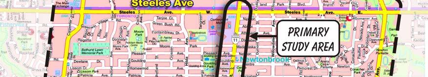


15 FIGURE 1 Study Area 14
16 FIGURE 2 Curb Reserved Bus Lane Design Concept 15
17 FIGURE 3 Median Reserved Bus Lane Design Concept 16
4 DISRUPTION MANAGEMENT PLAN HIGHWAY 7 RAPIDWAY CONSTRUCTION BETWEEN BAYVIEW AVENUE AND WARDEN AVENUE TOWNS OF MARKHAM AND RICHMOND HILL
 4 DISRUPTION MANAGEMENT PLAN HIGHWAY 7 RAPIDWAY CONSTRUCTION BETWEEN BAYVIEW AVENUE AND WARDEN AVENUE TOWNS OF MARKHAM AND RICHMOND HILL The Transportation Services Committee recommends the adoption of
APPENDIX 2 LAKESHORE ROAD TRANSPORTATION REVIEW STUDY EXECUTIVE SUMMARY
 APPENDIX 2 LAKESHORE ROAD TRANSPORTATION REVIEW STUDY EXECUTIVE SUMMARY Appendix 2 City of Mississauga Lakeshore Road FINAL REPORT Transportation Review Study December 2010 EXECUTIVE SUMMARY Study Purpose
Transportation Master Plan Advisory Task Force
 Transportation Master Plan Advisory Task Force Network Alternatives & Phasing Strategy February 2016 BACKGROUND Table of Contents BACKGROUND Purpose & Introduction 2 Linking the TMP to Key Council Approved
Operational Comparison of Transit Signal Priority Strategies
 Operational Comparison of Transit Signal Priority Strategies Revision Submitted on: November, 0 Author: Adriana Rodriguez, E.I Assistant Engineer Parsons Brinckerhoff 0 South Orange Avenue, Suite 00 Orlando,
CITY OF VAUGHAN EXTRACT FROM COUNCIL MEETING MINUTES OF OCTOBER 30, 2012
 CITY OF VAUGHAN EXTRACT FROM COUNCIL MEETING MINUTES OF OCTOBER 30, 2012 Item 31, Report No. 39, of the Committee of the Whole, which was adopted without amendment by the Council of the City of Vaughan
EXECUTIVE SUMMARY OF CALEDON TRANSPORTATION NEEDS STUDY
 EXECUTIVE SUMMARY OF CALEDON TRANSPORTATION NEEDS STUDY The Caledon Transportation Needs Study has been undertaken as a joint project by the Town of Caledon and the Region of Peel to determine the existing
Appendix 1 Transit Network Analysis
 Appendix 1 Transit Network Analysis APPENDIX 1 TRANSIT NETWORK ANALYSIS The purpose of this appendix is to provide an update on the transit network analysis as it pertains to: i. SmartTrack ii. Scarborough
DUNBOW ROAD FUNCTIONAL PLANNING
 DUNBOW ROAD FUNCTIONAL PLANNING Final Report August 3, 216 #31, 316 5th Avenue NE Calgary, AB T2A 6K4 Phone: 43.273.91 Fax: 43.273.344 wattconsultinggroup.com Dunbow Road Functional Planning Final Report
METHODOLOGY. Signalized Intersection Average Control Delay (sec/veh)
") Chapter 5 Traffic Analysis 5.1 SUMMARY US /West 6 th Street assumes a unique role in the Lawrence Douglas County transportation system. This principal arterial street currently conveys commuter traffic
Chapter 5 Traffic Analysis 5.1 SUMMARY US /West 6 th Street assumes a unique role in the Lawrence Douglas County transportation system. This principal arterial street currently conveys commuter traffic
York Region Population and Employment Growth
 March 1, 2016 1 York Region Population and Employment Growth York Region needs to comply with The Provincial Growth Plan and new forecasts introduced to 2036 and 2041 2 Regional Official Plan Review York
8 PROPOSED ROUNDABOUT DUFFERIN STREET AND KING VAUGHAN ROAD INTERSECTION CITY OF VAUGHAN
 8 PROPOSED ROUNDABOUT DUFFERIN STREET AND KING VAUGHAN ROAD INTERSECTION CITY OF VAUGHAN The Transportation Services Committee recommends the adoption of the recommendation contained in the following report
TRAFFIC IMPACT ANALYSIS
 TRAFFIC IMPACT ANALYSIS FOR THE CHAMPAIGN UNIT#4 SCHOOL DISTRICT PROPOSED HIGH SCHOOL (SPALDING PARK SITE) IN THE CITY OF CHAMPAIGN Final Report Champaign Urbana Urbanized Area Transportation Study 6/24/2014
ENHANCED PARKWAY STUDY: PHASE 2 CONTINUOUS FLOW INTERSECTIONS. Final Report
 Preparedby: ENHANCED PARKWAY STUDY: PHASE 2 CONTINUOUS FLOW INTERSECTIONS Final Report Prepared for Maricopa County Department of Transportation Prepared by TABLE OF CONTENTS Page EXECUTIVE SUMMARY ES-1
Main-McVay Transit Study: Phase 2 Options Definition and High Level Constraints Evaluation
 Main-McVay Transit Study: Phase 2 Options Definition and High Level Constraints Evaluation APRIL 2016 A collaborative study between: For Additional Information or to Comment If you would like additional
102 Avenue Corridor Review
 February 26, 2015 102 Avenue Corridor Review Transportation Association of Canada Road Safety Engineering Award Submission for the City of Edmonton Introduction Transportation Association of Canada Road
University Hill Transportation Study Technical Memorandum Alternatives Modeling and Analysis May 2007
 Technical Memorandum May 2007 Syracuse Metropolitan Transportation Council Edwards and Kelcey with Wallace Roberts and Todd Alta Planning and Design CONTENTS SECTION ONE- INTRODUCTION...1 SECTION TWO-
Scottsdale Road/Rural Road Alternatives Analysis (AA) Study. Arizona ITE/IMSA Spring Conference March 7, 2012
 Study. Arizona ITE/IMSA Spring Conference March 7, 2012") Scottsdale Road/Rural Road Alternatives Analysis (AA) Study Arizona ITE/IMSA Spring Conference March 7, 2012 Study Location and Duration Primary Study Corridor (major focus of effort) Rural Road and Scottsdale
Scottsdale Road/Rural Road Alternatives Analysis (AA) Study Arizona ITE/IMSA Spring Conference March 7, 2012 Study Location and Duration Primary Study Corridor (major focus of effort) Rural Road and Scottsdale
Southwest Bus Rapid Transit (SW BRT) Functional Planning Study - Executive Summary January 19 LPT ATTACHMENT 2.
 Functional Planning Study - Executive Summary January 19 LPT ATTACHMENT 2.") Southwest Bus Rapid Transit (SW BRT) Functional Planning Study - Executive Summary 2011 January 19 1 of 19 Introduction This executive summary presents the results of the Southwest Bus Rapid Transit (SW
Southwest Bus Rapid Transit (SW BRT) Functional Planning Study - Executive Summary 2011 January 19 1 of 19 Introduction This executive summary presents the results of the Southwest Bus Rapid Transit (SW
TRANSPORTATION NEEDS ASSESSMENT
 TRANSPORTATION NEEDS ASSESSMENT A travel demand analysis was carried out to determine the operational issues and the potential benefit that adding traffic capacity would have on the road network. All the
3 TRAFFIC CONTROL SIGNAL TIMING AND SYNCHRONIZATION
 Report No. 8 of the Transportation Services Committee Regional Council Meeting of October 20, 2011 3 TRAFFIC CONTROL SIGNAL TIMING AND SYNCHRONIZATION The Transportation Services Committee recommends:
Transportation Impacts: Toronto York Spadina Subway Extension
 STAFF REPORT ACTION REQUIRED Transportation Impacts: Toronto York Spadina Subway Extension Date: June 6, 2011 To: From: Wards: Reference Number: North York Community Council Director, Transportation Services
City of Hamilton s Transportation Master Plan (TMP) Public Consultation 3 December 2015
 Public Consultation 3 December 2015") City of Hamilton s Transportation Master Plan (TMP) Public Consultation 3 December 2015 McPhail Transportation Planning Services Ltd. AGENDA 6:00 7:00 pm Viewing Boards / Q & A with the Team 7:00 7:50
City of Hamilton s Transportation Master Plan (TMP) Public Consultation 3 December 2015 McPhail Transportation Planning Services Ltd. AGENDA 6:00 7:00 pm Viewing Boards / Q & A with the Team 7:00 7:50
In station areas, new pedestrian links can increase network connectivity and provide direct access to stations.
 The Last Mile Planning for Pedestrians Planning around stations will put pedestrians first. Making walking to stations safe and easy is important; walking will be a part of every rapid transit Accessible
Appendix B: Forecasting and Traffic Operations Analysis Framework Document
 Existing Conditions Report - Appendix Appendix B: Forecasting and Traffic Operations Analysis Framework Document This document defines the methodology and assumptions that will be used in the traffic forecasting
Richmond-Adelaide Cycle Tracks
 Public Drop-In Event Richmond-Adelaide Cycle Tracks June 25, 2018 12:00 p.m. 3:00 p.m. 4:30 p.m. 7:30 p.m. Metro Hall, Rotunda 55 John Street 1 Purpose of Event In Scope Communicate an update about the
WELCOME TO OPEN HOUSE # 1 June 14, 2017
 Langstaff Road Weston Road to Highway 7 Class Environmental Assessment Study WELCOME TO OPEN HOUSE # 1 June 14, 2017 Please sign in and join our mailing list Purpose of Open House #1 & Study Area York
5858 N COLLEGE, LLC N College Avenue Traffic Impact Study
 5858 N COLLEGE, LLC nue Traffic Impact Study August 22, 2016 Contents Traffic Impact Study Page Preparer Qualifications... 1 Introduction... 2 Existing Roadway Conditions... 5 Existing Traffic Conditions...
Welcome. The Brooklin Secondary Plan and Transportation Master Plan are collectively referred to as the Brooklin Study.
 Welcome The Town of Whitby is undertaking a study to prepare a Secondary Plan and Transportation Master Plan to guide and manage growth in the Brooklin area. The Brooklin Secondary Plan and Transportation
ROUTES 55 / 42 / 676 BUS RAPID TRANSIT LOCALLY PREFERRED ALTERNATIVE
 ROUTES 55 / 42 / 676 BUS RAPID TRANSIT LOCALLY PREFERRED ALTERNATIVE April, 2012 1 INTRODUCTION The need for transit service improvements in the Routes 42/55/676 corridor was identified during the Southern
Sixth Line Development - Transit Facilities Plan
 Memorandum Date: November 13, 2012 To: From: c.c. Subject: Rob Freeman (Freeman Planning) Kevin Phillips Sixth Line Development - Transit Facilities Plan 33016631 This memo was prepared to review the transit
Frequently Asked Questions (FAQ)
") Frequently Asked s (FAQ) Study Process... 2 Rapid Transit Service and Operations... 5 Public Consultation... 8 Business Impacts... 8 Design and Property Impacts... 9 Construction Impacts...12 Traffic,
Frequently Asked s (FAQ) Study Process... 2 Rapid Transit Service and Operations... 5 Public Consultation... 8 Business Impacts... 8 Design and Property Impacts... 9 Construction Impacts...12 Traffic,
EUCLID AVENUE PARKING STUDY CITY OF SYRACUSE, ONONDAGA COUNTY, NEW YORK
 EUCLID AVENUE PARKING STUDY CITY OF SYRACUSE, ONONDAGA COUNTY, NEW YORK CITY OF SYRACUSE DEPARTMENT OF PUBLIC WORKS 1200 CANAL STREET EXTENSION SYRACUSE, NEW YORK 13210 DRAFT REPORT DATE: November 13,
2.0 LANE WIDTHS GUIDELINE
 2.0 LANE WIDTHS GUIDELINE Road Engineering Design Guidelines Version 2.0.1 May 2018 City of Toronto, Transportation Services City of Toronto Page 0 Background In early 2014, Transportation Services initiated
TORONTO TRANSIT COMMISSION REPORT NO.
 Revised: March/13 TORONTO TRANSIT COMMISSION REPORT NO. MEETING DATE: January 28, 2014 SUBJECT: IMPROVING PEDESTRIAN SAFETY AND CUSTOMER JOURNEY TIMES: TRANSIT STOPS ACTION ITEM RECOMMENDATIONS It is recommended
Tonight is an opportunity to learn about the Study and ask questions of the Study Team members.
 Exhibit 1 Welcome Second Open House Tonight is an opportunity to learn about the Study and ask questions of the Study Team members. A first Public Open House was held on September 18th, 2013 which presented
5.0 Roadway System Plan
 Southwest Boise Transportation Study Page 16 5.0 Roadway System Plan The Roadway System Plan outlines roadway improvements in the Initial Study Area. It forecasts future deficiencies on the arterial system,
AMEC Earth and Environmental. Bovaird Drive Environmental Assessment. Traffic Study Final Report. August Excellence in Transportation Planning
 AMEC Earth and Environmental Bovaird Drive Environmental Assessment Traffic Study Final Report August Excellence in Transportation Planning AMEC Earth and Environmental Bovaird Drive Class EA Traffic
Executive Summary BEYOND THE B-LINE: RAPID TRANSIT LINE PHASE II - COMMERCIAL DRIVE WEST. Final Draft December 13, Appendix B BROADWAY/LOUGHEED
 BEYOND THE B-LINE: BROADWAY/LOUGHEED RAPID TRANSIT LINE PHASE II - COMMERCIAL DRIVE WEST Appendix B Executive Summary Final Draft December 13, 1999 UMA Lloyd Lindley Davidson Yuen Simpson Architects BROADWAY/LOUGHEED
Harbord Street and Hoskin Avenue Bicycle Lane Upgrades
 STAFF REPORT ACTION REQUIRED and Bicycle Lane Upgrades Date: April 22, 2014 To: From: Wards: Reference Number: Public Works and Infrastructure Committee General Manager, Transportation Services 19 and
Baseline Road Rapid Transit: Bayshore Station to Prince of Wales Drive
 Baseline Road Rapid Transit: Bayshore Station to Prince of Wales Drive Planning and Environmental Assessment Study Consultation Group Meetings May 2014 Presentation Agenda Study Overview Study Progress
Chapter 4 Traffic Analysis
 Chapter 4 Traffic Analysis PURPOSE The traffic analysis component of the K-68 Corridor Management Plan incorporates information on the existing transportation network, such as traffic volumes and intersection
WELCOME Public Information Centre
 WELCOME Public Information Centre Fernforest Drive Brampton Soccer Centre Community Room #2 Tuesday January 19, 2016 6:30 p.m.to 9:00 p.m. Please sign in Neighbourhood Traffic Calming Guide Background
122 Avenue: 107 Street to Fort Road
 : 107 Street to Fort Road November 24, 2015 4:30 8:00 p.m. Meeting Purpose Summarize project work completed to date Share results of public input from Phase 1 Share the draft concept plan and proposed
Los Altos Hills Town Council - June 18, 2015 Palo Alto City Council June 22, AGENDA ITEM #2.B Presentation
 Los Altos Hills Town Council - June 18, 2015 Palo Alto City Council June 22, 2015 AGENDA ITEM #2.B Presentation Previous Presentations Los Altos Hills Town Council in May 2014 and February 2015 Palo Alto
City of Homewood Transportation Plan
 City of Homewood Transportation Plan Prepared for: City of Homewood, Alabama Prepared by: Skipper Consulting, Inc. May 2007 TABLE OF CONTENTS INTRODUCTION... 1 BACKGROUND INFORMATION... 1 EXISTING TRANSPORTATION
Implementing Complete Streets in Ottawa. Project Delivery Process and Tools Complete Streets Forum 2015 October 1, 2015
 Implementing Complete Streets in Ottawa October 1, 2015 The Essentials Complete Streets Implementation Framework will become part of the routine delivery of City transportation projects Approach uses every
Shockoe Bottom Preliminary Traffic and Parking Analysis
 Shockoe Bottom Preliminary Traffic and Parking Analysis Richmond, Virginia August 14, 2013 Prepared For City of Richmond Department of Public Works Prepared By 1001 Boulders Pkwy Suite 300, Richmond, VA
WEST AND SOUTH WEST RING ROAD DOWNSTREAM TRAFFIC IMPACTS
 Page 1 of 9 EXECUTIVE SUMMARY Alberta Transportation ( AT ) is preparing to construct the final sections of the Calgary Ring Road. This includes the South West Ring Road ( SWRR ) (from Lott Creek Blvd
Highway 111 Corridor Study
 Highway 111 Corridor Study June, 2009 LINCOLN CO. HWY 111 CORRIDOR STUDY Draft Study Tea, South Dakota Prepared for City of Tea Sioux Falls Metropolitan Planning Organization Prepared by HDR Engineering,
4. ENVIRONMENTAL IMPACT ANALYSIS 9. TRANSPORTATION AND TRAFFIC
 4. ENVIRONMENTAL IMPACT ANALYSIS 9. TRANSPORTATION AND TRAFFIC 4.9.1 INTRODUCTION The following section addresses the Proposed Project s impact on transportation and traffic based on the Traffic Study
7 Yonge and Steeles Area Regional Transportation Study City of Markham and City of Vaughan
 Clause 7 in Report No. 17 of Committee of the Whole was adopted, without amendment, by the Council of The Regional Municipality of York at its meeting held on November 19, 2015. 7 Yonge and Steeles Area
Having held a public hearing, that Council approve:
 3. MODIFICATIONS TO MERIVALE ROAD FROM FALLOWFIELD ROAD TO OLD HIGHWAY 16 TO ACCOMMODATE THE GROWTH WITHIN THE SOUTH MERIVALE BUSINESS PARK - PUBLIC HEARING COMMITTEE RECOMMENDATIONS Having held a public
Existing Conditions. Date: April 16 th, Dan Holderness; Coralville City Engineer Scott Larson; Coralville Assistant City Engineer
 Date: April 16 th, 2015 To: From: Re: Dan Holderness; Coralville City Engineer Scott Larson; Coralville Assistant City Engineer Darian Nagle-Gamm, Traffic Engineering Planner Highway 6 (2 nd Street) /
Transportation Assessment
 Transportation Assessment Midtown Open House February 10, 2018 Overview Midtown in Focus Overview & Purpose of Today Transportation Assessment overview Summary of Transportation work to date Review & Analysis
Moving Cambridge. City of Cambridge Transportation Master Plan Public Consultation Centre. March 7, :00 8:00 PM.
 City of Cambridge Transportation Master Plan Public Consultation Centre March 7, 2018 5:00 8:00 PM Region of Waterloo City of Cambridge Transportation Master Plan Public Consultation Centre March 7, 2018
#!! "$% ##! &! # '#! % $ #!
 Executive Summary US Highway 16 (US 16) is the primary corridor connecting Rapid City to the Black Hills region. It serves a growing population of commercial and residential traffic, as well as seasonal
Improving Cyclist Safety at the Dundas Street West and Sterling Road Intersection
 STAFF REPORT ACTION REQUIRED Improving Cyclist Safety at the Dundas Street West and Sterling Road Intersection Date: August 17, 2012 To: From: Wards: Reference Number: Public Works and Infrastructure Committee
Chapter 3 BUS IMPROVEMENT CONCEPTS
 Chapter 3 BUS IMPROVEMENT CONCEPTS The purpose of this chapter is to describe potential bus improvement strategies and potential impacts or implications associated with BRT implementation within the existing
Capital Region Council of Governments
 March 23, 2018 Capital Region Council of Governments PROJECT CONCEPT REPORT Realignment of Swamp and Northfield Road s approaches to Route 44 (Boston Turnpike) Town of Coventry SUMMARY: The Town of Coventry
MoPac South: Impact on Cesar Chavez Street and the Downtown Network
 MoPac South: Impact on Cesar Chavez Street and the Downtown Network Prepared by: The University of Texas at Austin Center for Transportation Research Prepared for: Central Texas Regional Mobility Authority
Introduction Roundabouts are an increasingly popular alternative to traffic signals for intersection control in the United States. Roundabouts have a
 HIGH-CAPACITY ROUNDABOUT INTERSECTION ANALYSIS: GOING AROUND IN CIRCLES David Stanek, PE and Ronald T. Milam, AICP Abstract. Roundabouts have become increasingly popular in recent years as an innovative
Regional Transportation Needs Within Southeastern Wisconsin
 Regional Transportation Needs Within Southeastern Wisconsin #118274 May 24, 2006 1 Introduction The Southeastern Wisconsin Regional Planning Commission (SEWRPC) is the official areawide planning agency
Durham Region Long Term Transit Strategy
 Durham Region Long Term Transit Strategy An adaptive, safe, reliable, frequent, accessible and desirable transit system that shapes and connects Durham Region and beyond in an economically and environmentally
Welcome to the Open House
 Leslie Street Between 19 th Avenue and Stouffville Road Addendum to Class Environmental Assessment Study Welcome to the Open House Please sign in at the front desk. March 28, 2017 Richmond Green Sports
POLICY: TRAFFIC CALMING
 2006 MAY REFERENCE: COUNCIL APPROVED BY COUNCIL MAY 23, 2006 CITY OPERATIONS - NO. 608 POLICY: TRAFFIC CALMING A. All requests for traffic calming within the City shall be considered in accordance with
Figure 1: East West Connector Alignment Alternatives Concept Drawing
 Page 2 of 9 Figure 1: East West Connector Alignment Alternatives Concept Drawing The Montebello Drive extension will run north south and connect Wilsonville Road to the Boones Ferry Road to Brown Road
Title. Metropolitan Council Transportation Committee December 12, Brad Larson Metro District MnDOT
 Title Metropolitan Council Transportation Committee December 12, 2016 Evaluating the potential for Bus Rapid Transit and MnPASS Express Lanes in the southwest Metro Brad Larson Metro District MnDOT Background
Brian McHugh, Buckhead Community Improvement District. SUBJECT: Wieuca Road at Phipps Boulevard Intersection Improvements Project
 MEMO TO: FROM: Brian McHugh, Buckhead Community Improvement District Jagan Kaja, AICP, WSP Parsons Brinckerhoff SUBJECT: Wieuca Road at Phipps Boulevard Intersection Improvements Project DATE: October
2. NORTEL CARLING CAMPUS EXPANSION - PROPOSED MODIFICATIONS TO MOODIE DRIVE (REGIONAL ROAD 59) AND HIGHWAY 417 INTERCHANGE
 AND HIGHWAY 417 INTERCHANGE") 2. NORTEL CARLING CAMPUS EXPANSION - PROPOSED MODIFICATIONS TO MOODIE DRIVE (REGIONAL ROAD 59) AND HIGHWAY 417 INTERCHANGE COMMITTEE RECOMMENDATIONS AS AMENDED That Council approve: 1. The endorsement
2. NORTEL CARLING CAMPUS EXPANSION - PROPOSED MODIFICATIONS TO MOODIE DRIVE (REGIONAL ROAD 59) AND HIGHWAY 417 INTERCHANGE COMMITTEE RECOMMENDATIONS AS AMENDED That Council approve: 1. The endorsement
Tonight is for you. Learn everything you can. Share all your ideas.
 Strathcona Neighbourhood Renewal Draft Concept Design Tonight is for you. Learn everything you can. Share all your ideas. What is Neighbourhood Renewal? Creating a design with you for your neighbourhood.
WHITE PAPER: TRANSIT SERVICE FOR SOUTH SHAGANAPPI
 9/27/2012 TRANSIT PLANNING WHITE PAPER: TRANSIT SERVICE FOR SOUTH SHAGANAPPI 2012 Calgary Transit 1 Table of Contents Purpose... 3 Area of Change... 3 Background... 3 Access to destinations... 5 Connecting
Preliminary Transportation Analysis
 Preliminary Transportation Analysis Goals of a Robust, Multimodal Transportation Network Safe Accessible/Connected Efficient Comfortable Context-Sensitive Motor Vehicle: Continue to analyze the data to
Markham Sports, Entertainment and Cultural Centre Transportation Overview
 Markham Sports, Entertainment and Cultural Centre Transportation Overview ARENA LOCATION 2 3 TRANSPORTATION VISION IN MARKHAM On April 12, 2011, Markham Council adopted a long-term Transportation Vision
City of Wayzata Comprehensive Plan 2030 Transportation Chapter: Appendix A
 A1. Functional Classification Table A-1 illustrates the Metropolitan Council s detailed criteria established for the functional classification of roadways within the Twin Cities Metropolitan Area. Table
Wyldewood Estates. Pre-Application Public Engagement Summary of Issues and Responses
 Wyldewood Estates Pre-Application Public Engagement Summary of Issues and Responses March 2016 Executive Summary Morguard Residential Properties has been thoughtfully planning the redevelopment of Wyldewood
Corporate. Report COUNCIL DATE: June 26, 2006 NO: C012 COUNCIL-IN-COMMITTEE. TO: Mayor & Council DATE: June 22, 2006
 Corporate NO: C012 Report COUNCIL DATE: June 26, 2006 COUNCIL-IN-COMMITTEE TO: Mayor & Council DATE: June 22, 2006 FROM: General Manager, Engineering FILE: 0410-20(MoT/Gate) SUBJECT: Surrey Response on
SAN FRANCISCO MUNICIPAL TRANSPORTATION AGENCY
 THIS PRINT COVERS CALENDAR ITEM NO. : 11 DIVISION: Sustainable Streets BRIEF DESCRIPTION: SAN FRANCISCO MUNICIPAL TRANSPORTATION AGENCY Approving traffic modifications on Twin Peaks Boulevard between Christmas
REPORT CONCURRENCE. City Manager. The General Manager concurs with the recommendation of this report.
 COUNCIL REPORT Report No. ENG 08-018 Executive Committee Date: May 0, 018 File No: 5400-1 To: From: Subject: Mayor and Council Purvez Irani, Senior Transportation Engineer Bluejay Street Road Improvements
Dawson, Liu, Xu, Cheu, and Machemehl Page 1
 Dawson, Liu, Xu, Cheu, and Machemehl Page 1 Publish information: Eugene, D. H., H. Liu, and R.B. Machemehl (2011). Assessing the Feasibility of Converting Two Way Left Turn Lane into Bus Rapid Transit
Chapter 16: Traffic and Parking A. INTRODUCTION
 Chapter 6: Traffic and Parking A. ITRODUCTIO This chapter examines the potential traffic and parking impacts of the proposed Fresh Kills Park roads. The analysis of transit and pedestrians is presented
CHAPTER 7 ACCESS MANAGEMENT. Background. Principles of Access Management. Hennepin County Transportation Systems Plan (HC-TSP)
") CHAPTER 7 ACCESS MANAGEMENT Background Principles of Access Management Hennepin County Transportation Systems Plan (HC-TSP) Chapter 7 Access Management 7.1 Background Access management has become an important
CHAPTER 7 ACCESS MANAGEMENT Background Principles of Access Management Hennepin County Transportation Systems Plan (HC-TSP) Chapter 7 Access Management 7.1 Background Access management has become an important
Classification Criteria
 SCHEDULE D TO RECOMMENDED OFFICIAL PLAN AMENDMENT NO. 40 SCHEDULE C-4 Road Criteria Criteria Traffic Service Objective Land Service/Access Typical Daily Traffic Volume Flow characteristics Travel Speed
CITY OF HAMILTON PLANNING AND ECONOMIC DEVELOPMENT DEPARTMENT Transportation Planning and Parking Division
 CITY OF HAMILTON PLANNING AND ECONOMIC DEVELOPMENT DEPARTMENT Transportation Planning and Parking Division TO: Chair and Members Public Works Committee COMMITTEE DATE: June 18, 2018 SUBJECT/REPORT NO:
Simulating Street-Running LRT Terminus Station Options in Dense Urban Environments Shaumik Pal, Rajat Parashar and Michael Meyer
 Simulating Street-Running LRT Terminus Station Options in Dense Urban Environments Shaumik Pal, Rajat Parashar and Michael Meyer Abstract The Exposition Corridor transit project is a light rail project
Welcome. If you have any questions or comments on the project, please contact:
 Welcome This drop-in public open house is intended to provide information about the Bay Street bike lanes project. This project proposes a dedicated cycling facility along Bay Street between Aberdeen Avenue
Road Alterations - Wellington Street East, Church Street, and Front Street Intersection
 REPORT FOR ACTION Road Alterations - Wellington Street, Church Street, and Front Street Intersection Date: November 1, 2016 To: Toronto and York Community Council From: Director, Public Realm Section,
At each type of conflict location, the risk is affected by certain parameters:
 TN001 April 2016 The separated cycleway options tool (SCOT) was developed to partially address some of the gaps identified in Stage 1 of the Cycling Network Guidance project relating to separated cycleways.
Community Task Force March 14, 2018
 Community Task Force March 14, 2018 Welcome and Introductions Project Partners Regional Transportation District (RTD) City of Aurora Colorado Department of Transportation (CDOT) Denver Regional Council
3. EXISTING TRANSPORTATION CONDITIONS
 3. EXISTING TRANSPORTATION CONDITIONS Eglinton Avenue spans 35 kilometres across the centre of Toronto, from Kingston Road near Lake Ontario in the east to the Pearson Airport in the west. The corridor
2.2 TRANSIT VISION 2040 FROM VISION TO ACTION. Emphasize transit priority solutions STRATEGIC DIRECTION
 TRANSIT VISION 2040 FROM VISION TO ACTION TRANSIT VISION 2040 defines a future in which public transit maximizes its contribution to quality of life with benefits that support a vibrant and equitable society,
CITY OF OTTAWA ROADWAY MODIFICATION APPROVAL UNDER DELEGATED AUTHORITY
 RMA-2015-ATM-038 CITY OF OTTAWA ROADWAY MODIFICATION APPROVAL UNDER DELEGATED AUTHORITY DATE: April 22, 2015 SUBJECT Approval of Roadway Modifications Recommended through an Area Traffic Management Study
VIVA RETIREMENT COMMUNITIES OAKVILLE TRAFFIC IMPACT STUDY
 VIVA RETIREMENT COMMUNITIES OAKVILLE TRAFFIC IMPACT STUDY VIVA RETIREMENT COMMUNITIES OAKVILLE TRAFFIC IMPACT STUDY DECEMBER 2012 READ, VOORHEES & ASSOCIATES TORONTO, ONTARIO Read, Voorhees & Associates
Public Information Centre
 WELCOME Public Information Centre Father Tobin Road Lougheed Middle School - Library Wednesday November 7, 2012 7:00 p.m.to 9:00 p.m. Please sign in Neighbourhood Traffic Calming Guide Background The City
1. Provide a dedicated westbound approach bus lane at the intersection;
 3. MODIFICATIONS AT HIGHWAY 417 WESTBOUND OFF-RAMP/PINCREST ROAD - PUBLIC HEARING COMMITTEE RECOMMENDATIONS Having held a public hearing, that Council approve the preliminary design for the proposed modifications
Public Event 1 Community Workshops
 Public Event 1 Community Workshops Nov. 24 & Dec. 3, 2016 Welcome Workshop Purpose We re looking to you for ideas and insights to help guide future transportation infrastructure planning in the Park Lawn
Focused Traffic Analysis for the 200 Nellen Avenue Project
 March 13, 2017 Mr. Phil Boyle Town of Corte Madera 300 Tamalpais Drive Corte Madera, CA 94976-0159 Focused Traffic Analysis for the 200 Nellen Avenue Project Dear Mr. Boyle; W-Trans has completed a focused
Standing Committee on Policy and Strategic Priorities
 POLICY REPORT Report Date: January 15, 2019 Contact: Steve Brown Contact No.: 604.873.9733 RTS No.: 12955 VanRIMS No.: 08-2000-20 Meeting Date: January 30, 2019 TO: FROM: SUBJECT: Standing Committee on
ON STREET TRANSIT PRIORITY MEASURES PUTTING BUSES FIRST IN WINNIPEG
 ON STREET TRANSIT PRIORITY MEASURES PUTTING BUSES FIRST IN WINNIPEG David Wiebe, P.Eng. Associate, Dillon Consulting Limited (presenter) Dave Krahn, P.Eng. Partner, Dillon Consulting Limited 200-895 Waverley
Complete Street Analysis of a Road Diet: Orange Grove Boulevard, Pasadena, CA
 Complete Street Analysis of a Road Diet: Orange Grove Boulevard, Pasadena, CA Aaron Elias, Bill Cisco Abstract As part of evaluating the feasibility of a road diet on Orange Grove Boulevard in Pasadena,
Welcome to the McKenzie Interchange Project Open House!
 Welcome to the McKenzie Interchange Project Open House! Purpose of Open House To provide you with information regarding the project and for you to have the opportunity to share your input on design concepts.