ST ASAPH STREET POST CONSTRUCTION ROAD SAFETY AUDIT
|
|
|
- Luke Newman
- 5 years ago
- Views:
Transcription


1 REPORT ST ASAPH STREET POST CONSTRUCTION ROAD SAFETY AUDIT Prepared for Christchurch City Council 13 March 2017
2

3 This document has been prepared for the benefit of Christchurch City Council. No liability is accepted by this company or any employee or sub-consultant of this company with respect to its use by any other person. This disclaimer shall apply notwithstanding that the report may be made available to other persons for an application for permission or approval to fulfil a legal requirement. QUALITY STATEMENT PROJECT MANAGER AUDIT TEAM LEADER PREPARED BY CHECKED BY SAT REVIEWED BY SAT APPROVED FOR ISSUE BY... / / / /... / /... / / CHRISTCHURCH Hazeldean Business Park, 6 Hazeldean Road, Addington, Christchurch 8024 PO Box , Armagh, Christchurch 8141 TEL , FAX REVISION SCHEDULE Rev No Date Description Signature or Typed Name (documentation on file). Prepared by Checked by Reviewed by Approved by Status: Project No.: Child No.: March 2017 Our ref: P:\_2012 Onwards\Christchurch City Council\ CCC Cap Prog Grp Proj2 2015\St Asaph Street\RSA Report_St Asaph.docx
4 Christchurch City Council St Asaph Street CONTENTS 1 Introduction Safety Audit Definition and Purpose The Project The Road Safety Audit Team Previous Road Safety Audits Scope of This Road Safety Audit Report Format Documents Provided Disclaimer Safety Concerns General Issues Speed Environment / Operating Speed Parking Movements - Comment Left Turn Movements Into and out of access ways Lane Width Separator Formation Width and Height Delineation Line Markings Bus Stops Refuse Bins / Rubbish Collection Left Turn Signal Phase Ferry Road / St Asaph Street Intersection Vehicles entering Separated Cycleway Intersection Function Cycleway Markings Bus / Vehicle blocking Cycleway Madras Street / St Asaph Intersection Partial Implementation Audit Statement Response and Decision Statements Designer s Responses Safety Engineer s Comments (if applicable) Project No.: Child No.: 0106 Page 1 Our ref: RSA Report_St Asaph
5 4.3 Project Manager s Decisions Designer s Statement Safety Audit Close Out LIST OF TABLES Table 1-1: Concern Assessment Rating Matrix... 4 Table 1-2: Concern Categories... 4 LIST OF FIGURES Figure 1-1: Project Location... 2 Figure 2: Current Central City 30 km/h speed limit area Figure 2-3: Design Drawing of intersection Figure 2-4: Actual controls and markings installed APPENDICES Appendix A... 1 Project No.: Child No.: 0106 Page 2 Our ref: RSA Report_St Asaph
6 1 Introduction 1.1 Safety Audit Definition and Purpose A road safety audit is a term used internationally to describe an independent review of a future road project to identify any safety concerns that may affect the safety performance. The audit team considers the safety of all road users and qualitatively reports on road safety issues or opportunities for safety improvement. A road safety audit is therefore a formal examination of a road project, or any type of project which affects road users (including cyclists, pedestrians, mobility impaired etc.), carried out by an independent competent team who identify and document road safety concerns. A road safety audit is intended to help deliver a safe road system and is not a review of compliance with standards. The primary objective of a road safety audit is to deliver a project that achieves an outcome consistent with Safer Journeys and the Safe System approach, which is a safe road system increasingly free of death and serious injury. The road safety audit is a safety review used to identify all areas of a project that are inconsistent with a Safe System and bring those concerns to the attention of the client so that the client can make a value judgement as to appropriate action(s) based on the risk guidance provided by the safety audit team. The key objective of a road safety audit is summarised as: to deliver completed projects that contribute towards a safe road system that is increasingly free of death and serious injury by identifying and ranking potential safety concerns for all road users and others affected by a road project. A road safety audit should desirably be undertaken at project milestones such as: concept stage (part of business case); scheme or preliminary design stage (part of pre-implementation); detail design stage (pre-implementation or implementation); or pre-opening or post-construction stage (implementation or post-implementation). A road safety audit is not intended to be a technical or financial audit and does not substitute for a design check of standards or guidelines. Any recommended treatment of an identified safety concern is intended to be indicative only, and to focus the designer on the type of improvements that might be appropriate. It is not intended to be prescriptive and other ways of improving the road safety or operational problems identified should also be considered. In accordance with the procedures set down in the NZTA Road Safety Audit Procedures for Projects Guidelines - Interim release May 2013 the audit report should be submitted to the client who will instruct the designer to respond. The designer should consider the report and comment to the client on each of any concerns identified, including their cost implications where appropriate, and make a recommendation to either accept or reject the audit report recommendation. For each audit team recommendation that is accepted, the client will make the final decision and brief the designer to make the necessary changes and/or additions. As a result of this instruction the designer shall action the approved amendments. The client may involve a safety engineer to provide commentary to aid with the decision. Decision tracking is an important part of the road safety audit process. A decision tracking table is embedded into the report format at the end of each set of recommendations. It is to be completed by the designer, safety engineer, and client for each issue, and should record the designer s response, client s decision (and asset manager's comments in the case where the client and asset manager are not one and the same) and action taken. A copy of the report including the designer's response to the client and the client's decision on each recommendation shall be given to the road safety audit team leader as part of the important feedback loop. The road safety audit team leader will disseminate this to team members. Project No.: Child No.: 0106 Page 1 Our ref: RSA Report_St Asaph

7 1.2 The Project The following section details the nature of the project. Source: PublicInformationLeaflet-StAsaphStreet-fromFerryRoadtoAntiguaStreet This is the first project in Phase 2 of An Accessible City. The proposal connects Central City cycleways to other Major Cycleway Routes in Christchurch. It is also required to complete the one-way system westbound through the Central City. Enhanced cycling network: A separated cycleway is proposed on St Asaph Street between Ferry Road and Antigua Street. This is in preparation for future connectivity with proposed Major Cycle Routes. The proposed cycleway will also connect to other Central City key cycle routes. One of these is the cycleway already being constructed on Tuam Street. When finished the major east-west cycle routes at the southern end of Central City will be completed. Enhanced one-way street network: St Asaph Street is currently one-way and forms part of a westbound one-way main distributor street pairing with Tuam Street (carrying eastbound traffic). As an essential component of the travel network in the Central City, St Asaph Street remains a one-way corridor for the majority of its length with two westbound general traffic lanes throughout, supplemented by turning lanes at some intersections. This maintains the efficiency of St Asaph as a priority car and bus route. Enhanced environment: As outlined in the consultation plans, some enhancements to the landscaping are included such as new median islands and build-outs, replacement trees and improved lighting. Figure 1-1: Project Location Source: PublicInformationLeaflet-StAsaphStreet-fromFerryRoadtoAntiguaStreet Project No.: Child No.: 0106 Page 2 Our ref: RSA Report_St Asaph
8 1.3 The Road Safety Audit Team This road safety audit has been carried out in accordance with the NZTA Road Safety Audit Procedure for Projects Guidelines Interim release May 2013, by: Name Position Company National Specialist Road Safety Technical Director Civil Engineering MWH Beca 1.4 Previous Road Safety Audits The SAT are aware that a Detailed Design Road Safety Audit had been undertaken prior to the commencement of the construction. At the time of writing this report, the SAT had not sighted this RSA, nor its findings. Therefore, this RSA is undertaken as a fresh pair of eyes over the design and implementation. The SAT are aware, through site observations, that there have been changes to the design that have been incorporated into the final construction. The SAT are not aware if these changes have in themselves been reviewed for the impact on road user safety and functionality. Subsequent to the field inspections, and during the finalisation of this report, the SAT were provided a copy of the previous report for their information. The SAT note that the report provided did not have any designer s responses, or client decisions. It is assumed by the SAT that these have been undertaken as required under the Road Safety Audit Guidelines. 1.5 Scope of This Road Safety Audit This is a post construction Safety Audit. The SAT has generally limited their comments to works that have been completed only (refer to section 2). However, given a number of safety concerns raised to Council, the SAT has been requested to consider additional elements that may not necessarily be typically included in a RSA. These include: Consideration of the suggested amendments to design as detailed in Appendix A, The effect of the new street layout on deliveries necessary for business, The effect that the change of parking capacity has on the safe use of the street, The SAT therefore have utilised principles outlined in the accepted Safety Audit and Network Functionality (SANF) review process. The methodology for this Road Safety Audit (RSA) is in line with that specified in the NZTA Road Safety Audit Procedures for Projects Guideline, (Interim release May 2013) ), which utilises the Safe Systems approach. This approach includes the Safe System objectives that focus on the provision of forgiving roads and roadsides that are more accommodating of human error, and managing the crash forces to a level that the human body can tolerate without serious injury. It is recognised that while road safety audits of projects tend to be focused on the road and interrelationship of the driver with the road, all cornerstones of a safe system are important and intertwined. Key to the safe system approach is the consideration of vulnerable road users (pedestrians and cyclists) along with motorised road users. As defined in the NZTA guideline, the focus of the Safe System approach in Safety Auditing includes: Provide forgiving roads and roadsides Limit crash forces to prevent fatal and serious injuries Understand road user perception of roads and roadsides Consider both historic and predictive modelling The process used by the auditors included: 1. Undertaking a desktop analysis of the supplied plans and documentation, Project No.: Child No.: 0106 Page 3 Our ref: RSA Report_St Asaph
9 2. Undertaking an on-site review of the design to identify the impacts of the proposed design on the form and function of the road environment, 3. Observe the behaviours of all road users, 4. Undertaking an initial assessment of the items identified and the impacts on the road network, including an assessment of the ranking of concerns in accordance with the NZTA RSA Guidelines (2013 Interim Release), 5. Compiling a formal report for presentation to the project team. 1.6 Report Format The potential road safety problems identified have been ranked as follows. The expected crash frequency is qualitatively assessed on the basis of expected exposure (how many road users will be exposed to a safety issue) and the likelihood of a crash resulting from the presence of the issue. The severity of a crash outcome is qualitatively assessed on the basis of factors such as expected speeds, type of collision, and type of vehicle involved. Reference to historic crash rates or other research for similar elements of projects, or projects as a whole, have been drawn on where appropriate to assist in understanding the likely crash types, frequency and likely severity that may result from a particular concern. The frequency and severity ratings are used together to develop a combined qualitative risk ranking for each safety issue using the concern assessment rating matrix in Table 1-1. The qualitative assessment requires professional judgement and a wide range of experience in projects of all sizes and locations. Table 1-1: Concern Assessment Rating Matrix Severity (likelihood of death or serious injury) Frequency (probability of a crash) Frequent Common Occasional Infrequent Very likely Serious Serious Significant Moderate Likely Serious Significant Moderate Moderate Unlikely Significant Moderate Minor Minor Very unlikely Moderate Minor Minor Minor While all safety concerns should be considered for action, the client or nominated project manager will make the decision as to what course of action will be adopted based on the guidance given in this ranking process with consideration to factors other than safety alone. As a guide a suggested action for each concern category is given in Table 1-2. Table 1-2: Concern Categories Concern Serious Significant Moderate Minor Suggested action Major safety concern that must be addressed and requires changes to avoid serious safety consequences. Significant safety concern that should be addressed and requires changes to avoid serious safety consequences. Moderate safety concern that should be addressed to improve safety. Minor safety concern that should be addressed where practical to improve safety. In addition to the ranked safety issues it is appropriate for the safety audit team to provide additional comments with respect to items that may have a safety implication but lie outside the scope of the safety audit. A comment may include items where the safety implications are not yet clear due to insufficient detail for the stage of project, items outside the scope of the audit such as existing issues not impacted by the project or an opportunity for improved safety but not necessarily linked to the project itself. While Project No.: Child No.: 0106 Page 4 Our ref: RSA Report_St Asaph
10 typically comments do not require a specific recommendation, in some instances suggestions may be given by the auditors. The SANF review is required to fulfil two purposes; a road safety audit that takes into account all users, and an assessment of the network functionality of the MCR for all users. To fulfil the requirements of a safety audit the team has adopted the assessment system of the Road Safety Audit Procedures for Projects (Interim release May refer to Appendix B) with the ranking of each issue raised on a progressive scale of importance from minor, moderate, significant to serious. In accordance with this formal process, the SANF review includes under each safety issue identified a decision tracking box to document how each safety issue is addressed, and the decisions required of the design team going forward in the design. 1.7 Documents Provided The SAT was provided with the following documents for this audit. Plan Reference Sheets Title Rev Accessible City - C01 - RD Construction Issue 8 - CP Accessible City - R03, - RRD Construction Issue 8 - CP Accessible City R05 - RD Construction Issue 8 - CP Accessible City - R06 - RD Construction Issue 8 - CP Accessible City - R08 - RD Construction Issue 8 - CP Accessible City - R09 - RD Construction Issue 8 - CP Accessible City - R10 - RD Construction Issue 8 - CP Accessible City - R12 - RD Construction Issue 8 - CP Accessible City - R31 - RD Construction Issue 8 - CP Accessible City - R32 - RD Construction Issue 8 - CP Accessible City - R35 - RD Construction Issue 8 - CP Accessible City - R36 - RD Construction Issue 8 - CP Accessible City - R37 - RD Construction Issue 8 - CP Accessible City - R38 - RD Construction Issue 8 - CP Cover Sheet 13 Plan 1 Plan 1 Plan and Paving Plans 1 Plan and Paving Plans 1 Plan and Paving Plans 1 Plan and Long Section 1 Plan and Long Section 1 Road Marking Plan 1 Road Marking Plan 1 Tree Planting Plan 1 Tree Planting Plan 1 Tree Planting Plan 1 Planting Plan 1.8 Disclaimer The findings and recommendations in this report are based on an examination of available relevant plans, the specified road and its environs, and the opinions of the SAT. However, it must be recognised that eliminating safety concerns cannot be guaranteed since no road can be regarded as absolutely safe and no warranty is implied that all safety issues have been identified in this report. Safety audits do not constitute a design review nor are they an assessment of standards with respect to engineering or planning documents. Readers are urged to seek specific technical advice on matters raised and not rely solely on the report. While every effort has been made to ensure the accuracy of the report, it is made available on the basis that anyone relying on it does so at their own risk without any liability to the safety audit team or their organisations. Project No.: Child No.: 0106 Page 5 Our ref: RSA Report_St Asaph
11 2 Safety Concerns The reader is advised that many of these issues are inter-related, and as such the issues cannot be read in isolation. The SAT advise that technical advice from the relevant experts should be sought to fully understand the nature and extent of the issues raised. This Road Safety Audit has been presented to generally identify the road safety concerns raised as a result of the inspections. The SAT have met with Council project staff to discuss these issues, and to discuss verbally some of the remedial treatments proposed to address concerns raised by others. 2.1 General Issues select from the list The SAT undertook a series of site inspections at different times of the day, over a series of days, to assess the operating environment for different levels of traffic flows and times. This included morning peak, off-peak (daytime), evening peak, and off peak (night). In addition to this, the SAT individually observed the street during periods of wet night conditions. To fully understand the look and feel of the street, the SAT undertook numerous opportunities to drive through, as well as cycle through, the network to appreciate the environment first hand. This allowed the SAT to observe the operation and configuration of the street under different conditions, to determine if any identified issue is common to all times of the day, or specific to an isolated time frame or operating condition. The following sections outline issues that the SAT have observed, and offer a commentary on the specifics of the issues. This includes positive aspects that have been done well, and could be incorporated in further designs (where necessary). This later group have been identified as comments Speed Environment / Operating Speed Significant The SAT reviewed the new road formation of St Asaph Street, from the Ferry Road / St Asaph Street intersection, through to the Antigua Street / St Asaph Street intersection. The Antigua Street intersection was excluded from the audit as it is currently under redevelopment as part of the An Accessible City TP 1B project. The applied street design for St Asaph Street generally has a kerb to kerb dimension (between build outs) of 6.6 m allowing for the formation of two lanes of approximately 3.3 m width, along with kerbside parking (where applied) of approximately m width. A separated uni-directional cycle path of 2 m is provided along the southern kerb line of the original road alignment. This is separated from the parking spaces by a nominal 1.1m raised island. This width varies throughout the project depending on the width of the kerb build outs. This nominal separator width is the desirable width specified in the Christchurch City Council Cycle Design Guidelines: Part B; Design Principles Best Practice Guide. The SAT undertook a series of drive through exercises, and observed the progression speed of traffic under varying density of traffic flow. It was observed that under normal operating conditions, the posted speed limit of 50km/h could not be achieved due to the sequencing of the traffic signals, and the general nature of vehicle movements. Discussions with the CTOC Real Time Operations Team reveal that the normal progression of traffic along St Asaph Street is around 30 km/h (taken from their real-time monitoring of traffic signals). Off peak (day), the speed of progression is again determined by the complexity of parking movements along the street, and the signal phasing of the intersecting north-south streets. Typically, the signal phasing s are set by the SCATS system to determine the best optimisation of progression for all directions of travel. An override of the system to advance the progression of one street will often slow the progression of the opposing streets. Off peak night the phasing is set for a 30 km/h progression along the route. While a 50 km/h speed could be achieved between each intersection block (a distance of approximately 220 m), this would result in a stop at each intersecting cross roads intersection for the red phase. The introduction of the new kerb narrowing s (build outs) associated with the new design has incorporated elements required to correctly position the driver into the lane, minimise the risk of drivers Project No.: Child No.: 0106 Page 6 Our ref: RSA Report_St Asaph
 travel times, the inclusion of kerb side parking creates an element of street narrowing, visually reinforcing a busy street operating")


12 turning into the new cycle lane, along with the opportunity to provide street side parking facilities that are sheltered from the through lane. The SAT note that during peak travel times, and off peak (day) travel times, the inclusion of kerb side parking creates an element of street narrowing, visually reinforcing a busy street operating environment. Photo 1: Example of new constrained road environment. Note low conspicuity of kerb. Photo 2: Example of kerb build outs to achieve protection for parked vehicles, and correct placement of traffic signals. The SAT observe that the operating environment, and the progression speeds reinforce a speed slower than that legally posted at 50km/h. Physically, the through progression speed capable, given the signal sequencing is around 30 km/h. Observations on site reveal that cars undertaking a turn into properties currently appear to be rushed, with the driver concerned with the speed / proximity of following traffic. At higher speeds, this effect is amplified, resulting in rapid turn in movements. Similarly, the turn out movement requires the driver to identify a gap in the traffic stream. Typically they should be concentrating on the nearside lane, however it was noted on a few occasions where the driver departed directly across to the off side lane to undertake a right turn at the next intersection. Retaining the current 50 km/h through traffic speed, given the complexity of parking and turn movements, can result in more frequent nose to tail crashes, along with an increased risk of crashes with drivers turning left over the cycle lane, resulting in potentially high severity side impact crashes (cyclist into side of car, or car into side of cyclist). St Asaph Street is on the southern boundary of the central city 30 km/h cordon area (Refer to Figure 2). It is noted that Colombo Street has a 30 km/h speed limit southward to Moorhouse Avenue. Figure 2: Current Central City 30 km/h speed limit area. Project No.: Child No.: 0106 Page 7 Our ref: RSA Report_St Asaph
13 Recommendation(s) Given that the normal day progression speed is around 30 km/h, the SAT recommends that the legal speed limit be lowered to 30 km/h to better reflect the speed environment, and match the actual operating speed. Frequency Crashes are likely to be common Designer response Safety Engineer comment Client decision Severity Death or serious injury is likely Rating The safety concern is significant Action taken Parking Movements - Comment select from the list The St Asaph Street design substantially changes the layout of the street and the environment in which it operates, when compared to the wide open nature of the old street layout. The new design is conducive to the changed environment of the central city core, and is noted to be in keeping with the overall scheme plan for the central city. This plan places an equal emphasis on all modes of travel, be they motor vehicle, cycle or pedestrian. This includes the effect of the new environment to elements such as entering and exiting road side parking spaces. As stated in Section 2.1.1, the parking stall widths are approximately m in width. These parking stall widths typically encourage tight parking to the kerb face for private vehicles, with larger vehicles (up to 2.4 m in width) overhanging the marked stall space. Observations of parking movements throughout all site visits reveal that, as is typical for busy central city streets, drivers often drive past, stop and reverse into tight parking spaces. This requires following traffic to stop in their lane to allow this movement to occur. Where there is a suitable manoeuvre space, drivers were observed driving nose first into a parking space, and reversing to final position, with some drivers opting to drive onto and over the low kerbs to minimise the impact on the traffic. This movement is generally undertaken at a slow speed and also requires the following driver to slow and / or stop. Other vehicles, mainly 4WD / Ute type vehicles, drive over the kerb build outs into the parking bays. These parking movements are made more complex when the parking space is located on the right hand side of the road, as is with St Asaph Street. In this instance, the driver is on the kerb side, and has a better gauge of adjacent parked vehicle positions when entering. However, upon exit, the driver is placed on the off-side of the road traffic lane, and has poor rearward visibility due to the vehicle geometry, and the acute rearward view angle (over the shoulder, left side). This is typical for a one way street, and is appropriate for St Asaph Street as this movement is on the opposite side of the road from the cycle facility. The placement of street planters along the street assist with the definition of the reduced road corridor, and provide a level of speed management. These planters also provide protection from drivers undertaking (illegally passing on the right hand side of a vehicle that is in a traffic lane) at speed to advance along the parking shoulder. This situation would mainly occur at off peak times, or low traffic density. Project No.: Child No.: 0106 Page 8 Our ref: RSA Report_St Asaph


14 The planters installed generally have a sloped face (in respect to the traffic direction of travel) that assists drivers with entry and exit movements. The provision of perpendicular ends results in an impeded ability to easily enter and exit the parking space. Photo 3: Example of new planter north side. Note lack of plants installed to define vertical element. Photo 4 Submissions have been made concerning the risk of opening doors being impacted by through traffic. Generally, if an impact with a door occurs, it would result in vehicle damage only, especially at the current 30 km/h operating speed. The SAT do acknowledge that if a driver alighting from a parked vehicle took no care in exiting their vehicle, then there may be a risk of a glancing impact from a through vehicle. It is important to note that this could occur anywhere on the road network, and is not necessarily a function of the St Asaph Street design only. The SAT have reviewed this operation and note the following: 1. The driver of a parked vehicle must make sure that the road corridor is safe to open the door, 2. The definition of the parking space is generally well done with paint markings, 3. The position of through traffic is not well defined. Currently the lane is represented as the space between the road centreline and the edge of the parking space. The SAT consider that an appropriate form of marking or guidance is required to better position the through traffic to their lane, moving the passing traffic away from the parked vehicle, offering an increased margin for door opening. This would also offer a greater margin of safety for pedestrians walking out mid-block between parked vehicles to cross the road. Recommendation(s) Install an appropriate form of marking or guidance to better position the through traffic in their lane, moving the passing traffic away from the parked vehicle, offering an increased margin for door opening, and improved safety for people walking out from between parked vehicles. Frequency Crashes are likely to be infrequent Designer response Safety Engineer comment Client decision Severity Death or serious injury is unlikely Rating The safety concern is minor Project No.: Child No.: 0106 Page 9 Our ref: RSA Report_St Asaph


15 Frequency Crashes are likely to be infrequent Action taken Severity Death or serious injury is unlikely Rating The safety concern is minor Left Turn Movements Into and out of access ways Significant The access to properties to the south of St Asaph Street will be undertaken through a left turn in movement, over the newly formed separated cycle facility. It is noted that at most access points, the design has incorporated a kerb build-out to increase the tightness of the left turn, resulting in a lower speed as they enter onto the cycle facility that provides the priority through movement to the cyclist. While cycling through the facility, a member of the SAT also encountered a series of occasions where rapid braking was required to avoid a left turn movement undertaken by a driver of a vehicle. During these times, it was the slow speed created by the kerb build out that ensured that the crossing speeds were low, and a suitable reaction could be undertaken. Cyclists utilising the cycle facility do so from within a confined space, with little opportunity to undertake a lateral avoidance movement. It was observed that many commute cyclists were travelling at speeds estimated to be between 20 km/h and 30 km/h along the cycle facility. This operating speed for cyclists could result in turning drivers having difficulty in assessing gaps within the cycle stream. While on site the SAT were made aware of a left turn crash involving a car turning in front of a cyclist. This crash resulted in minor injuries not requiring medical attention (bruising / abrasions). The SAT immediately notified the Council of the crash and location for their attention. It is important to note that under the traffic regulations, the left turn driver is at all times required to give way to all cyclists and pedestrians undertaking a through movement along the street, irrespective of a separated cycleway or not. The SAT are mindful of the reduction in available parking created by the kerb build-outs along the street, and have considered these in relation to the streetscape, user safety and parking capacity. The SAT are of the mind that the kerb build outs are necessary for the correct positioning and orientation of left turn traffic, and to importantly protect the sight line to the right for exiting drivers. Photo 5: Example of left turn in protection offered by kerb build out. Note utilisation of this space for cycle parking and street art (installed by local business) Photo 6: Example of unprotected left turn in. Driver is positioned such that they cannot see back down cycle facility. As discussed, this left turn will be required to be undertaken from the through lane, and the driver will be subject to pressure to depart the traffic lane from traffic formed behind. Project No.: Child No.: 0106 Page 10 Our ref: RSA Report_St Asaph


16 The absence of any kerb build out at the left turn position will poorly position the driver undertaking the left turn, potentially resulting in poor visibility of approaching cyclists. Furthermore the allowance of a loading zone or parking space immediately adjacent to this turn location, will block all visibility of approaching cyclists, and block the visibility for exiting drivers, resulting in them having to nose out into the traffic stream with no sight of approaching traffic. This greatly increases the risk of blocking the cycle lane or side impact into exiting vehicles, with the potential for serious injury. The SAT have reviewed the applied markings and coloured surfacing at these left turn movement locations, and have a number of concerns on their impact. The green surfacing applied is well done, appropriate, and is consistent with all other cycle facilities currently being installed throughout Christchurch, and New Zealand. However, the SAT are concerned that the symbols applied are directed at the cyclist, and not the driver of an entering / exiting vehicle. It is not typically the role of the SAT to offer solutions to the problems identified. However, at the request of Council, the SAT have considered that nature of the risks present, and propose some typical solutions that may address (at least in part) the concerns raised. A recent study of the St Vincent Street separated facility in Nelson has demonstrated that the orientation of the cycle symbols to the entering / exiting driver, along with an arrow for the direction that the cyclist is approaching from, offers a suitable solution. Furthermore there is no signage applied warning the driver that there is a risk of a cyclist approaching from behind them (masked by the parked vehicles). While signs at every access may not be appropriate, at key locations they may offer the best solution. The SAT consider that there may be opportunity to explore a solid barrier line on the traffic side of the cycleway green markings to highlight that the driver is crossing over a separated facility. In some locations throughout NZ, this barrier line is formed through the use of a low profile black and yellow raised separator. Photo 7: Example of low profile raised separator at access Bi-directional facility, Quay Street, Auckland Photo 8: Example of cycle marking for access points The SAT consider that in some locations, the applied kerb build outs are long, and could be utilised for an additional parking space, or with a reconfiguration of the parking, allow the inclusion of a loading zone / short stay, all the while keeping sufficient build out to protect the left turn movement sight lines. It is important to note that under the traffic regulations, it is illegal to park closer than 1m to the edge of an access point. An independent safety review undertaken for Council, with respect to sight lines and parking for separated cycle ways, has stated that this offset should typically be 3m minimum to maintain an appropriate level of intervisibility. When considering this 3 m (minimum) set-back requirement many existing kerb build outs, should they be removed, would not result in sufficient length to allow an additional parking space to be formed. Recommendation(s) 1. An appropriate treatment barrier / warning system should be investigated to highlight the risk of approaching cyclists to the left turn driver crossing the separated cycle facility. 2. Appropriate pavement markings should be investigated and applied to warn drivers that they are crossing over a legal through movement by cyclists. Project No.: Child No.: 0106 Page 11 Our ref: RSA Report_St Asaph
17 3. That any remedial changes to the size / location of the kerb build outs retain the width at the entrance end to ensure that the driver undertakes the turn from within the through lane, minimising the risk of turning over a cyclist in the through movement on the separated cycle facility. 4. Each access way should be assessed individually to determine if additional parking spaces can be installed that maintain the desired level of safety for the left turn in / left turn out movement. Frequency Crashes are likely to be common Designer response Safety Engineer comment Client decision Severity Death or serious injury is likely Rating The safety concern is significant Action taken Lane Width Significant The lane configuration, and the complexity of parking movements, is very similar to many other one way streets in close proximity, in that to access the parking stalls, a vehicle will be required to either drive in / drive out (typical if there is clear space before / after the park), or reverse parking. In the case of the latter, any following traffic will be required to stop until the parking manoeuvre is complete, or the driver changes lanes if safe to do so. The lane widths of 3.3 are typical for the central city environment under the revised street layout for Christchurch. This is similar to other one way roads such as Tuam Street, Montreal Street (new layout) and Durham Street. Of note was observations of large vehicles parking in the shoulder parking spaces, with a portion of the vehicle overhanging the through traffic lane. In addition, the SAT observed on numerous occasions where large and small vehicles (typically delivery vehicles) were parked within the through lane, blocking traffic. This action contravenes the traffic regulations (unless for an emergency situation), and causes significant safety risks to users of the street. Poor lane discipline can result in through vehicles impacting with opening doors, people alighting from their vehicles, and greatly increases the risk of impact with pedestrians emerging from between two parked cars, where their view line along the street will be impacted by parked vehicles, especially HCV and SUV type vehicles. Project No.: Child No.: 0106 Page 12 Our ref: RSA Report_St Asaph

 this width is amplified as a result of low form kerbs installed, and the lack of verticality close to the road edge.")
18 Photo 9: Example of larger SUV overhanging parking space. Note door into edge of traffic lane. Photo 10: Example of illegal parking by delivery vehicles Of note to the SAT is the lack of kerbside edge definition of the lane, resulting in poor positioning of the vehicle relative to the traffic lane, and allowing drivers to encroach closer to parked vehicles. During off peak times (night and weekends) this width is amplified as a result of low form kerbs installed, and the lack of verticality close to the road edge. The SAT consider that the placement of an appropriate edge definition, encouraging better lane discipline, is required to ensure that the through driver maintains an appropriate offset from parked vehicles. Recommendation(s) Include an appropriate edge line treatment to reinforce lane position for the through traffic driver creating a buffer to the parking space, and minimise the risk of impact with pedestrians, alighting vehicle occupants and vehicle doors opening. Frequency Crashes are likely to be common Designer response Safety Engineer comment Client decision Severity Death or serious injury is likely Rating The safety concern is significant Action taken Separator Formation Width and Height Significant Refer also to Sections and The formation of the separator has been undertaken in accordance with best international practice, that being with a kerb formation on each side of the cycle facility, as shown in Photo 11 below. This style of formation presents multiple kerb steps requiring people to step up and down from, especially those alighting from vehicles, or crossing midblock. It is noted that typically these steps would be on the kerb line on each side of the road. Project No.: Child No.: 0106 Page 13 Our ref: RSA Report_St Asaph


19 This style of cycleway design is new to Christchurch, and will require some adaption by users to the new design. It is noted however that the placement of multiple kerbs and steps is not new. In places throughout the city there are central median islands, kerb build outs as part of local area traffic management etc. It is noted that this issue is at most risk on the mid-block sections. Mid-block the pedestrian will be concentrating on the identification and acceptance of a gap in traffic. This heavy concentration on the traffic may result in a lower level of awareness of the actual ground conditions and level changes. At intersections full cut down facilities are installed for pedestrians in accordance with best practice. The SAT noted that at a number of locations the new formation offered poor visual contrast to these changes in height. With the new formation, it may be difficult for elderly and visually impaired users to define the edges due to the lack of tonal contrast this instance. Key to this safety issue is the education element of what the new designs incorporate, and how they should be utilised. A well-developed education campaign would raise the awareness of the design, and how this should be used. The awareness of the change in separator height can be mitigated through a mixture of treatments. These include: 1. Education of the public of the new facilities, and behaviours expected 2. placement of an appropriate contrast tonal marking in high pedestrian use zones, 3. Better enhancement of the kerb build outs through the use of items such as planters and possible signage. Photo 11: Example of typical separator formation. Photo 12: Example of cycle facility raised to footpath level, with concrete edge treatments to define path. Recommendation(s) 1. Undertake an education program for the public of the use of the new facilities, and behaviours expected. 2. Placement of an appropriate contrast tonal marking on separators / cycle facility edge in high pedestrian use zones, 3. Better enhancement of the kerb build outs through the use of items such as planters and possible signage. Project No.: Child No.: 0106 Page 14 Our ref: RSA Report_St Asaph


20 Frequency Crashes are likely to be occasional Severity Death or serious injury is very likely Rating The safety concern is significant In the instance where a pedestrian loses their footing and falls onto the traffic lane, the risk of DSI is very likely, all other situations would generally be considered unlikely. Elderly typically have a higher level of fragility, and could sustain a higher level of injury. Designer response Safety Engineer comment Client decision Action taken Delineation Moderate The SAT undertook both a daytime and night time assessment of the St Asaph Street layout to understand the nature and level of guidance provided to the motorist. It was noted that the new kerb formation produced a grey on grey tone, offering poor contrast to highlight the kerb units. To counter this, the project has installed red kerb top RRPM markers on the faces that are visible to the approaching driver. This delineation is at approximately 100 mm above the road surface. Of concern to the SAT was the high proportion of RRPM s that were absent evident by the adhesion marks on the kerb top. This would indicate that the attachment adhesive utilised has failed under general use, and the effect of vehicles running over the low profile kerb to access car parks or driving into access ways. This overrun gets worse as more units are knocked off, resulting in a higher level of impacts onto the units, resulting in a greater level of loss. Photo 13: Example of RRPM loss Photo 14: Example of Red RRPM installed on kerb top. Recommendation(s) 1. Install appropriate delineation devices to highlight the kerb edges, especially during night time off-peak and weekend use. Project No.: Child No.: 0106 Page 15 Our ref: RSA Report_St Asaph


21 2. Undertake immediate remedial repairs of installed red RRPM s Frequency Crashes are likely to be occasional Designer response Safety Engineer comment Client decision Severity Death or serious injury is likely Rating The safety concern is moderate Action taken Line Markings Moderate Delineation can also take the form of road markings, where reflectorized road markings provide the level of channelization required for general night operations. It was observed that there was a very high level of poor road markings, resulting in an inconsistent and inappropriate level of guidance. This was found to be accentuated at night, especially during wet road conditions, where the old road markings (ones not refreshed) disappeared from view due to the wet surface and poor retro reflectivity. This will result in poor lane discipline for drivers as they will be unable to judge where the actual lane is. Photo 15: Example of old and ineffective pavement markings Manchester St / St Asaph St. Photo 16: Example of conflicting markings (including ghost markings from old road layout) In many instances the new road alignment has required the removal of the old road lane lines. These have been removed by abrasion, and have resulted in ghost markings that become more apparent during wet weather. This creates confusion as often two line systems will be visible. The removal of old markings should not be hard to the existing edge of the marking this only creates a line that will become more apparent in the wet. The following excerpt from the New Zealand Road Markers Federation recommends the following for line removal: 5.1 Supporting Principles 1. Where line markings are removed permanently, that this is done in such a way that the chance of the motorist being confused as to position on the carriageway, particularly in wet weather and poor lighting conditions is minimised. Widening and softening the edges of existing markings may do this. Project No.: Child No.: 0106 Page 16 Our ref: RSA Report_St Asaph
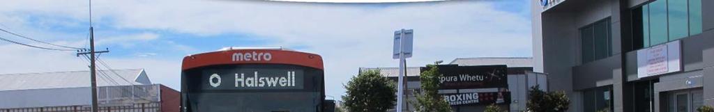
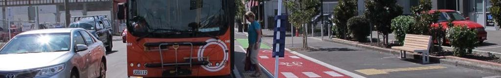
22 A new reconfiguration of a street such as this should be subject to a total remark of all lanes lines, and inclusion of additional edge lines (as required) to clearly define the new lanes. Given the poor performance of conventional markings during periods of wet weather and/or night conditions, it is recommended that an appropriate high profiled pavement marking system that performs well in wet conditions is incorporated for this, and all future projects of a similar nature. Recommendation(s) 1. That the project length is remarked utilising an appropriate high profiled pavement marking system that performs well in wet and / or dark conditions. 2. That all ghost markings be eliminated as much as possible noting the guidelines outlined by the Road Markers Federation, and that clear specifications be inserted into all future contracts of a similar nature. 3. Consider the use of temporary taped lane markings for future temporary works, or delay placing the final asphalt surfacing to minimise ghost markings. 4. Undertake a review of the specifications for all future major central city projects to ensure that an appropriate level or remark of all pavement markings is incorporated. Frequency Crashes are likely to be occasional Designer response Safety Engineer comment Client decision Severity Death or serious injury is likely Rating The safety concern is moderate Action taken Bus Stops Moderate The SAT note the introduction of a new and innovative treatment style for the cycle facility crossing over a bus stop. The SAT commend the approach. Key to this treatment style is the change of colour of the surfacing (red) and the placement of a compulsory Give Way control for cyclists approaching the bus stop. The provision of the cycle facility surface being at footpath level allows easy access for mobility impaired. The placement of seating away from the bus stop ensures that, in general, people waiting for the bus do so away from the through movement on the cycle facility. This control requires all cyclists to Give Way to passengers entering / exiting from a bus, when the bus is stationary at the bus stop. The current design has the bus timetable information installed on the pole immediately adjacent to the traffic lane side of the separator. This requires the pedestrian to cross over the cycle facility, read the information, and then cross back to the seating. This exposes the pedestrian to multiple opportunities for impact with a cyclist. The placement of the bus timetable on the footpath side of the cycle facility would minimise these conflicts. Project No.: Child No.: 0106 Page 17 Our ref: RSA Report_St Asaph
 1.")
23 Photo 17: Cyclists view on approach to bus stop. Note Give Way sign (circled) is lost in street furniture, and rubbish bin placed in the cycle facility. Photo 18: Bus patron utilising new facility. Note that they are in the shade of the bus and may not be clearly visible to cyclists using the system. Recommendation(s) 1. Install all bus timetable and route information on the footpath side of the cycle facility. 2. Ensure that all signs (esp Give Way) are located to optimise visibility. This will require an assessment of the sign location from the position where a user would be expected to readily observe a sign. Frequency Crashes are likely to be occasional Severity Death or serious injury is likely Rating The safety concern is moderate In the instance where a pedestrian steps inadvertently in front of a cyclist, the risk of DSI is likely. Elderly typically have a higher level of fragility, and could sustain a higher level of injury. Designer response Safety Engineer comment Client decision Action taken Refuse Bins / Rubbish Collection Moderate During the site inspections it was noted that there were instances of bins being placed within the separated cycle facility, or had fallen into the cycle facility following pickup. Project No.: Child No.: 0106 Page 18 Our ref: RSA Report_St Asaph

24 Photo 19: Example of rubbish bins placed in the cycle facility. Photo 20: Rubbish bins placed in the parking shoulder. Note bins topple into cycle lane and block entrance. This will result in cyclist s travel being compromised, with the risk of impact with a rubbish bin being high on collection day. The presence of vertical kerbs either side of the cycle facility restricts the cyclist s ability to safely take evasive action. Recommendation(s) Have all business be made aware of the required safe location for bins, and ensure that the rubbish collection contractors are informed on the safe placement of bins once emptied. Frequency Crashes are likely to be occasional Designer response Safety Engineer comment Client decision Severity Death or serious injury is likely Rating The safety concern is moderate Action taken Left Turn Signal Phase Significant It was observed on a number of instances and locations where the left turn motorist was held for the cycle through movement, yet no cyclists were present. This resulted in some motorists checking behind, while a number did not, before proceeding with the turn. There were instances observed where the motorist did not take any observance and compliance with the red left turn arrow, and turned directly in front of a cyclist s path, requiring the cyclist to brake hard. The SAT observed that there were advance detection loops installed on the cycle facility on the approach to an intersection. This assists in the recognition of cyclist approaching the intersection, and the correct phase being displayed. The SAT are mindful that having a priority cycle call on the red left turn arrow has advantages, and protects the through movement of cyclists. Given the separated nature of the cycle facility, and NZ traffic regulations requiring the formal control of left turn vehicles over the cycleway, this is considered Project No.: Child No.: 0106 Page 19 Our ref: RSA Report_St Asaph
25 appropriate, however could lead to frustration for an impatient driver. It is important to note that this style of left turn treatment is now being applied extensively throughout the central city as the Accessible City and Cycleway programs roll out. This will increase everyone s awareness of the required safe actions. Similarly, it was observed that there was a number of cyclists that chose to run the intersection while they had a red cycle symbol. This placed them directly exposed to a legal left turn movement by the motorist. It is the opinion of the SAT that a robust education campaign is required to the public and all users to highlight the safe operation of these left turn facilities. Recommendation(s) That the Council undertake an extensive education campaign on the new facilities, and the safe use expectations required of all users. This is to include deliveries, cyclists, motorists, and pedestrians. Frequency Crashes are likely to be common Designer response Safety Engineer comment Client decision Severity Death or serious injury is likely Rating The safety concern is significant Action taken 2.2 Ferry Road / St Asaph Street Intersection The reader is directed to consider that while each of the issues raised in this section has a specific rating identified, the cumulative effect of all of these items has resulted in an overall rating of Significant, and as such requires careful consideration and response that incorporates the elements to address all items Vehicles entering Separated Cycleway Moderate At the time of undertaking the site inspection, the SAT observed 3 vehicles drive down the separated cycleway within 30 minutes during the morning off peak travel time. All three vehicles had to reverse or turn and drive the wrong way out. These vehicles would have been blind to a cyclist entering from the Ferry Road (westbound) lane. Observations on site indicate that drivers are getting confused as to the westbound lane. This is due to the lack of physical separation, and apparent entry, at the cycle lane crossing. While close scrutiny of the intersection would reveal the cycle lane markings and coloured surface, to the approaching driver, requiring to make an instant decision, the clarity of the correct path is less defined. The designers should consider the placement of a vertical physical barrier (such as stick on bollards or hold loops) to visually restrict the entry into the cycleway. Project No.: Child No.: 0106 Page 20 Our ref: RSA Report_St Asaph

, in the interim it is strongly recommended the use of bollards to prohibit motorists")
26 Photo 21: The blue car comfortably driving along the 2 way cycle path. The man in the red top flagged down the car and got the driver to reverse back out of the cycle lane. Photo 22: The silver car on the right has just completed a 5 point turn at the Cashel Street end of the 2 way cycleway before heading back to Ferry Road. Recommendation(s) Improve the delineation and channelisation of Ferry Road traffic approaching the St Asaph Street intersection. While a wider review of the intersection layout and operation is recommended (discussed below in further detail), in the interim it is strongly recommended the use of bollards to prohibit motorists from accidentally accessing the cycle path. Frequency Crashes are likely to be occasional Designer response Safety Engineer comment Client decision Severity Death or serious injury is likely Rating The safety concern is moderate Action taken Intersection Function Significant The SAT understand the conflicting movements required at this intersection, and have considered these movements in relation to the current layout. Key to the safe operation of an intersection with complex movements such as this is the need to have the layout intuitive (as much as possible) to the road users. The SAT consider that the current intersection form does not deliver an intuitive layout, and requires multiple complex decisions to be made. Lack of visibility between westbound cyclist (Ferry) and westbound cyclist (St Asaph) when intersection running at capacity. Ferry cyclists required to give way to St Asaph cyclist Confusing signs for movements Multiple give way requirements that conflict for different users. Left turn driver into Ferry is required to give way (see Photo 25), yet in the same location cyclists are required to give way for eastbound movement. It is assumed that the give way requirement for cyclists is cyclist Project No.: Child No.: 0106 Page 21 Our ref: RSA Report_St Asaph
 is positioned in such a location that it legally applies (placed on the left side of the cycle lane) to the westbound cycle")

 from the Ferry Road Intersection.")

27 movement over the pedestrian crossing, however the sign also requires the cyclist to give way to left turn vehicles. The give way for the left turn movement (into Ferry Road) is positioned in such a location that it legally applies (placed on the left side of the cycle lane) to the westbound cycle movement. This conflicts with the priorities for the other approaches for the cycle lanes. Signs have been rotated to an incorrect direction Number of signs result in poor readability, blocked signs, conflicting / confusing layout. High number of signs causes confusion Photo 23: Confusing markings and signs Ferry Road / St Asaph Street intersection Photo 24: Confusing markings and signs Ferry Road / St Asaph Street intersection Photo 25: Confusing markings and signs Ferry Road / St Asaph Street intersection Photo 26: Example of cycle path exiting (eastbound) from the Ferry Road Intersection. Note pole damage to left. Recommendation(s) 1. That the designers undertake a review of the current design, noting these conflicts and constraints, and undertake a remedial design to address the issues. The signage needs to be intuitive and easy to read too much signage and the motorist/cyclists cannot absorb all the information in such a short decision time when entering the intersection. 2. It is strongly recommended that the design team observe driver behaviour on site to understand the conflicts and confusion that exist. Project No.: Child No.: 0106 Page 22 Our ref: RSA Report_St Asaph

28 Frequency Crashes are likely to be common Designer response Safety Engineer comment Client decision Severity Death or serious injury is likely Rating The safety concern is significant Action taken Cycleway Markings Significant Refer also to Section The cycle markings are confusing for the user. The green markings do not follow the path of the user as observed by the SAT. The ramp markings visually appear as a limit line reinforcing the indication that the cyclist is required to give way for the westbound movement. A review of the supplied plans indicate that the Detailed Design approved (refer to Figure 2-3) has the westbound (St Asaph) cyclist having to give way to the eastbound cyclist movement. The design drawing shows a large area of green surfacing covering the whole conflict zone at the Ferry Road intersection. It was observed that the green markings are confined to the path of the cycle lane only, reducing the effectiveness that total coverage would provide. Cyclists are approaching the intersection at generally 20km/h to 30km/h, however the markings (and signage) is reasonably complex and difficult to interpret when travelling at these speeds, especially when changing direction, and potentially giving way to other cyclists, motorists and pedestrians. The complex layout also coincides where vehicle stacking and buses entering St Asaph completely block the conflict zone of crossing cyclists. This is discussed further below. Figure 2-3: Design Drawing of intersection. Figure 2-4: Actual controls and markings installed. Project No.: Child No.: 0106 Page 23 Our ref: RSA Report_St Asaph
29 Recommendation(s) 1. The intersection layout needs to be reviewed to ensure the conflicting cycle movements are either avoided altogether or relocated so they do not occur at the same location as cars and buses queuing back on the Ferry Road approach to St Asaph Street. 2. Consider extending the St Asaph cycle lane further west across the Ferry Road intersection then merge into the existing 2 way path. 3. Consider extending the existing 2 way path further east along Ferry Road before crossing the eastbound cyclists to the north side of Ferry Road possibly as far down as at Barbadoes Street. 4. These changes will simplify the cycleway and minimises the conflict points, marking and signage. Frequency Crashes are likely to be common Designer response Safety Engineer comment Client decision Severity Death or serious injury is likely Rating The safety concern is significant Action taken Bus / Vehicle blocking Cycleway Significant Ferry Road is a dominant bus route. During the site inspections it was observed on numerous occasions that stacked vehicles waiting to turn from Ferry Road into St Asaph Street, be they cars or buses. A summary of issues is presented below: Bus s overhang facility multiple stack of vehicles causing cyclists to veer around and between vehicles, especially buses, Stacked buses blocking visibility for cyclist and eliminating cyclists ability to observe cyclists approaching along the system on Ferry Road approach to bi-directional facility, Drivers failing to look right upon exiting Ferry Road, driving directly into the path of an approaching cyclist on a permitted through movement, Project No.: Child No.: 0106 Page 24 Our ref: RSA Report_St Asaph
 Refer also to the recommendation in Section 2.2.3.")

30 Photo 27: Current design requires an exiting bus to straddle the new facility. Cyclists cannot see merging cyclists on opposite side of the bus Photo 28: Multiple cars parked over the new facility. This was observed at almost every time where vehicles queued for exit. Recommendation(s) Refer also to the recommendation in Section Due to the layout and operation of the intersection cyclists cannot safely use the cycleway as intended (including pedestrian using the zebra crossing). The existing layout needs to be revised to remove the conflicts and poor and unsafe interaction between all transport modes. Frequency Crashes are likely to be common Designer response Safety Engineer comment Client decision Severity Death or serious injury is likely Rating The safety concern is significant Action taken 2.3 Madras Street / St Asaph Intersection select from the list The Madras Street / St Asaph Street intersection will ultimately form the junction between two major cycle routes. To facilitate this, the new configuration has been installed, and temporary restrictions installed until full use is possible. The final configuration allows a signalised turn movement into and out of High Street Partial Implementation Significant The SAT acknowledge that the Madras Street / St Asaph Street intersection was incomplete in the implementation at the time of the RSA. It is understood that this portion of the project will be complete at a time when the linkage to the Tuam Street facility is complete, and approval for the new signals and controls for the Madras Street / St Asaph Street diagonal crossing has been approved for use. The SAT Have considered this partial implementation, and make the following comments: Project No.: Child No.: 0106 Page 25 Our ref: RSA Report_St Asaph

 have been observed aligning themselves for the westbound movement at the signals, from the inbound cycle lane.")
31 The outbound right turn movement lane is currently blocked by stick on bollards. However the SAT noted that cyclists were still using the inbound lane to exit over to High Street a movement that is not supported by signals control. Some traffic signal heads were covered to avoid confusion. It is understood that these aspects will become operational when the new crossing movement becomes active. Drivers entering into the bi-directional cycleway illegally (refer to Section 2.2.1) have been observed aligning themselves for the westbound movement at the signals, from the inbound cycle lane. A member of the SAT in the left hand most lane on St Asaph Street had a motorist advance from this position into the left hand lane, westbound. This is not a permitted movement, and could have resulted in a side swipe crash. Cyclists were observed using the inbound lane to bypass the red cycle phase, while St Asaph Street traffic is moving. There are incomplete line markings on the footpath that appear to be marked for removal these correspond to kerb cut-downs. The left hand traffic signal (westbound) for the cycle facility is partially masked by a preceding sign. The current dashed leader line between the St Asaph Street bi-directional facility, and the partially completed High Street facility. The current road markings do not give good guidance to the cyclists. The current line leads from the left hand side of the High street facility, onto the centre of the bi-directional facility. The use of a white line could miss-lead a driver. A change of colour to (say) green dashed would better represent the cycle path. The markings on Madras Street were incomplete, and resulted in what appeared to be an additional lane where cyclists were required to position for the northbound movement. Colouring of the road surface would be required to clearly define the cycle lanes to avoid motorists positioning themselves in the cycle lanes. Photo 29: Madras Street / St Asaph Street. Note footpath markings marked for removal? Photo 30: Sign masks primary traffic signal for cyclists. Project No.: Child No.: 0106 Page 26 Our ref: RSA Report_St Asaph

 The a full Road Safety Audit is undertaken of the completed installation at the time of opening (or immediately prior) Frequency Crashes are likely to be common Severity Death or")
32 Photo 31: Miss-aligned pavement markings for cyclists. Note this could be confused for conventional lane leader lines for drivers. Photo 32: Lack of green markings Madras Street. Given the incomplete nature of the current intersection, the SAT have not undertaken a full RSA for this component. This should be done once the facility is near to being opened, with the capacity to observe its full operation. Recommendation(s) The a full Road Safety Audit is undertaken of the completed installation at the time of opening (or immediately prior) Frequency Crashes are likely to be common Severity Death or serious injury is likely Rating The safety concern is significant This rating is based upon the risk that users will be unfamiliar with a signalised diagonal crossing, with cyclists entering into the intersection from a separated facility that will not be visible to drivers in the right hand most lane. Designer response Safety Engineer comment Client decision Action taken Project No.: Child No.: 0106 Page 27 Our ref: RSA Report_St Asaph
The Safe System Approach
 There are very few areas of public discussion and sentiment which generate as much consensus as road safety. Everyone wants safer roads for all users, and road safety is a key priority for governments,
At each type of conflict location, the risk is affected by certain parameters:
 TN001 April 2016 The separated cycleway options tool (SCOT) was developed to partially address some of the gaps identified in Stage 1 of the Cycling Network Guidance project relating to separated cycleways.
WAITEMATA GREENWAYS PRE-OPENING ROAD SAFETY AUDIT
 WAITEMATA GREENWAYS PRE-OPENING ROAD SAFETY AUDIT PREPARED FOR AUCKLAND TRANSPORT 20 December 2017 This document has been prepared for the benefit of Auckland Transport. No liability is accepted by this
Review of Guidelines for Cycleway Safety Fencing
 Review of Guidelines for Cycleway 1.0 PURPOSE 1.1 This document is meant to provide a review of available reference documents for determining appropriate fencing requirements for cycleway paths and shared
Section Outline Signalised Intersection Layout
 Advanced Planning and Design for Cycling Module 4 Intersections SECTION 2 SIGNALISED INTERSECTION LAYOUT Section Outline Signalised Intersection Layout Refresher: 6 elements of intersection design Providing
14. PROPOSED PEDESTRIAN CROSSING IMPROVEMENTS IN MOORHOUSE AVENUE
 165 14. PROPOSED PEDESTRIAN CROSSING IMPROVEMENTS IN MOORHOUSE AVENUE General Manager responsible: General Manager City Environment, DDI 941-8528 Officer responsible: Transport and Greenspace Unit Manager
Rhebogue Neighbourhood Greenway. Road Safety Audit Stage 2
 Rhebogue Neighbourhood Greenway Road Safety Audit Stage 2 Report Number: 12/007/00/00057 July 2014 Mid West National Road Design Office Lissanalta House, Dooradoyle County Limerick Tel: 061 496 800 Fax:
River Road - Proposed Road Safety Enhancement Measures
 City of Richmond Report to Committee To: From: Re: Public Works and Transportation Committee Victor Wei, P. Eng. Director, Transportation Date: June 6, 2017 River Road - Proposed Road Safety Enhancement
Response to further information request Ministry of Education Notice of Requirement (200 & 252 Park Estate Road)
") 21 Pitt Street PO Box 6345, Auckland 1141, New Zealand T: +64 9 300 9000 // F: +64 9 300 9300 E: info@beca.com // www.beca.com Auckland Council Private Bag 92300 Victoria Street West Auckland 1142 15 August
21 Pitt Street PO Box 6345, Auckland 1141, New Zealand T: +64 9 300 9000 // F: +64 9 300 9300 E: info@beca.com // www.beca.com Auckland Council Private Bag 92300 Victoria Street West Auckland 1142 15 August
NMT SAFE STUDY APPROACH
 24 May 2017 ADVOCATING THE NON MOTORISED TRANSPORT AGENDA CONTENT Content NMT road safety study approach NMT road safety study process NMT SAFE STUDY APPROACH THE NEED FOR NMT SAFETY STUDIES Is there is
Introduction Methodology Study area and data collection Results and recommendation Conclusion References
 Introduction Methodology Study area and data collection Results and recommendation Conclusion References It is formal procedure for assessing accident potential and safety performance in the provision
Guidelines for flush medians RTS 4
 Guidelines for flush medians RTS 4 November 1991 Reprinted July 2001 Land Transport Safety Authority PO Box 2840 Wellington Telephone: 04 494 8600 Facsimile: 04 494 8601 ISSN: 1170-5337 ISBN: 0-477-05267-3
Auckland Transport s responses to feedback on proposed upgrades to the intersection of Mercari way and Don Mckinnon Drive
 s to feedback on proposed upgrades to the intersection of way and Don Mckinnon Drive Points raised through feedback process 1 Congestion The proposal will improve traffic flow through the intersection
Sharrow Markings. Best Practice Guidance Note. February 2016
 Best Practice Guidance Note February 2016 Project: Title: Document Reference: Prepared by: Reviewed by: Revisions: Sharrow Markings Best Practice Guidance Note P:\NZTA\123 Best Practice Sharrow Guide\report\R1E160203
Part B Design Guidance / Principles _
 Part B Design Guidance / Principles www. landlab.co.nz Queenstown Town Centre Public Realm Design Guidelines Version 7 14 June 2018 Page 006 B1 Design Guidance & Best Practice The Queenstown Town Centre
Bus and Transit Lane Review Update
 Board Meeting / 25 February 2013 Agenda Item no.8(i) Bus and Transit Lane Review Update Glossary Auckland Transport New Zealand Transport Agency Transit Two Transit Three (AT) (NZTA) (T2) (T3) Executive
CHECKLIST 4: PRE-OPENING STAGE AUDIT
 CHECKLIST 4: PRE-OPENING STAGE AUDIT 4.1 General topics 4.1.1 Changes since previous audit; translation of design into practice General check: have any matters that have changed since a previous audit
Footpath design. A guide to creating footpaths that are safe, comfortable, and easy to use
 Footpath design A guide to creating footpaths that are safe, comfortable, and easy to use November 2013 Contents Introduction / 1 Zoning system / 2 Width / 4 Height / 5 Surface / 5 Footpath elements /
Appendix 12 Parking on footways and verges
 Appendix 12 Parking on footways and verges Legal position Parking on footways and verges whether wholly or partly is banned throughout London, unless signs are placed to allow parking. The ban requires
6. BREENS/GARDINERS/HAREWOOD INTERSECTION - SAFETY IMPROVEMENT PROJECT
 6. BREENS/GARDINERS/HAREWOOD INTERSECTION - SAFETY IMPROVEMENT PROJECT General Manager responsible: Officer responsible: Author: Jane Parfitt General Manager City Environment DDI 941 8656 Michael Aitken
10.0 CURB EXTENSIONS GUIDELINE
 10.0 CURB EXTENSIONS GUIDELINE Road Engineering Design Guidelines Version 1.0 March 2017 City of Toronto, Transportation Services City of Toronto Page 0 Background In early 2014, Transportation Services
Derby Cycling Group, c/o 126, Station road, Mickleover, Derby, DE3 9FN. Date: 20 th November, 2018.
 Your Ref: Derby City Council Air Quality - Preferred Option Nov 2018 Derby Cycling Group, c/o 126, Station road, Mickleover, Derby, DE3 9FN Date: 20 th November, 2018. 1. Introduction: 1.1. Derby Cycling
21. CHRISTCHURCH CYCLE LANES: PROPOSED COLOURED SURFACING CHANGE
 21. CHRISTCHURCH CYCLE LANES: PROPOSED COLOURED SURFACING CHANGE General Manager responsible: General Manager City Environment, DDI 941-8608 Officer responsible: Transport and Greenspace Manager Author:
SECTION 12 ROAD MARKINGS AND DELINEATION
 SECTION 12 20 June 2009 Part 3: Motorways and Expressways CONTENTS Reference Page Page Number Date SECTION 12: MARKINGS AND DELINEATION 12.1 GENERAL... 12-1 June 2009 12.1.1 INTRODUCTION... 12-1 June 2009
Appendix B Option 1 Design, Plans and Estimates
 19 Appendix B Option 1 Design, Plans and Estimates Opus International Consultants Ltd Design Details All options where designed using NZTA MOTSAM part 2, NCC Land development manual 2010 and Cycling
1 This technical note considers the issues associated with the use of tidal flow bus lanes on key public transport corridors in Cambridge.
 TECHNICAL NOTE: TIDAL FLOW BUS LANE OPTION ASSESSMENT Purpose 1 This technical note considers the issues associated with the use of tidal flow bus lanes on key public transport corridors in Cambridge.
SLOUGH Stage 3 Road Safety Audit of A4 London Road, M4 J5 to Sutton Lane
 SLOUGH Stage 3 Road Safety Audit of A4 London Road, M4 J5 to Sutton Lane Exception Report Client Officer Rudo Beremauro Date 20 January 2015 RSA /Project Sponsor s Contents Section 3 Project Sponsor's
CHECKLIST 2: PRELIMINARY DESIGN STAGE AUDIT
 CHECKLIST 2: PRELIMINARY DESIGN STAGE AUDIT 2.1 General topics 2.1.1 Changes since previous audit Do the conditions for which the scheme was originally designed still apply? (for example, no changes to
Appendix D Stage 1 Road Safety Audit
 N2 Monaghan Town to Emyvale Road Improvements Part 8 Application Description of Proposed Development Appendi D N2 Monaghan Town to Emyvale, County Monaghan Proposed Pavement and Minor Improvement Scheme
Issues at T junctions:
 TheSlade_PublicConsulationPlans_March2017.pdf These comments relate to junction designs in this phase of the project on The Slade. Comments begin with the northernmost junction: Girdlestone Rd and continue
Corporate. Report COUNCIL DATE: May 25, 1998 NO: R1500 REGULAR COUNCIL. TO: Mayor & Council DATE: April 27, 1998
 R1500 : Traffic Safety at 25 Avenue and 128 Street Intersection Corporate NO: R1500 Report COUNCIL DATE: May 25, 1998 REGULAR COUNCIL TO: Mayor & Council DATE: April 27, 1998 FROM: General Manager, Engineering
MILTON ROAD LLF PROJECT UPDATE
 Greater Cambridge City Deal MILTON ROAD LLF PROJECT UPDATE 9 th May 2017 Project objectives Comprehensive priority for buses in both directions wherever practicable; Additional capacity for sustainable
DESIGN CODE. Enterprise West Harlow London Road North Design Code 21
 DESIGN CODE Enterprise West Essex @ Harlow London Road North Design Code 21 4 MAXIMUM BUILDING HEIGHTS 4.1 Table 4A sets out maximum building height standards for each character area within the LDO boundary.
Frascati Road and Temple Hill Route Improvements. Outline Design Report to Accompany Public consultation
 Frascati Road and Temple Hill Route Improvements Outline Design Report to Accompany Public consultation September 2013 Background: Dún Laoghaire-Rathdown is committed to providing high quality pedestrian
Understanding school road safety
 Understanding school road safety 1. The purpose of these guidelines The safety of students travelling to and from school is one of the most important issues for school communities. Road environments around
Technical Director, Jacobs IHT Urban Design Panel. Challenge of MfS Acknowledgements visibility forward SSD side road SSD
 for Public Realm Schemes for Public Realm Schemes IHT London Branch evening meeting 30 September 009 Ken Huddart Kate Carpenter Technical Director, Jacobs IHT Urban Design Panel Kate Carpenter IHT Road
Economic and Social Council
 UNITED NATIONS E Economic and Social Council Distr. GENERAL TRANS/WP.1/2003/3/Rev.4 23 April 2004 ENGLISH Original: ENGLISH, FRENCH and RUSSIAN ECONOMIC COMMISSION FOR EUROPE INLAND TRANSPORT COMMITTEE
Economic and Social Council
 UNITED NATIONS E Economic and Social Council Distr. GENERAL 20 December 2006 ENGLISH Original: ENGLISH and FRENCH ECONOMIC COMMISSION FOR EUROPE INLAND TRANSPORT COMMITTEE Working Party on Road Traffic
CITY OF OTTAWA ROADWAY MODIFICATION APPROVAL UNDER DELEGATED AUTHORITY
 RMA-2015-ATM-038 CITY OF OTTAWA ROADWAY MODIFICATION APPROVAL UNDER DELEGATED AUTHORITY DATE: April 22, 2015 SUBJECT Approval of Roadway Modifications Recommended through an Area Traffic Management Study
Traffic Control Inspection Checklist Segment:
 Traffic Control Inspection Checklist Segment: Simon Contractors Simon Contractors Originator: Description Reviewed by: Initials Date Distribution: Traffic Quality Manager, Site Assistant Traffic Manager
DYNAMIC LANES FOR AUCKLAND
 Dynamic Lanes for Auckland MENEZES M. and INMAN R. Page 1 DYNAMIC LANES FOR AUCKLAND Authors: INMAN, Robert BA (Hons) Previously Auckland Transport Senior Traffic Engineer Now Aurecon Robert.Inman@aurecongroup.com
Cabinet Member for Highways & Streetscene. Highway Infrastructure Manager
 LONDON BOROUGH OF RICHMOND UPON THAMES DATE: AUGUST 2015 DECISION MAKER: LEAD OFFICER: SUBJECT: WARDS: Cabinet Member for Highways & Streetscene Highway Infrastructure Manager PROPOSED CYCLING IMPROVEMENTS
A105 Green Lanes junction with Bourne Hill / Hedge Lane
 Cycle Enfield - Section 5 A105 Green Lanes junction with Bourne Hill / Hedge Lane Stage 2 Road Safety Audit Ref: 2759.03.05/032/A105/BOR/2016 Prepared for: London Borough of Enfield By: Road Safety Audit,
Document 2 - City of Ottawa Pedestrian Crossover (PXO) Program
 Program") 40 Document 2 - City of Ottawa Pedestrian Crossover (PXO) Program OVERVIEW The City of Ottawa Pedestrian Crossover (PXO) Program provides the basis for PXO implementation in Ottawa. The program s processes
40 Document 2 - City of Ottawa Pedestrian Crossover (PXO) Program OVERVIEW The City of Ottawa Pedestrian Crossover (PXO) Program provides the basis for PXO implementation in Ottawa. The program s processes
8 PROPOSED ROUNDABOUT DUFFERIN STREET AND KING VAUGHAN ROAD INTERSECTION CITY OF VAUGHAN
 8 PROPOSED ROUNDABOUT DUFFERIN STREET AND KING VAUGHAN ROAD INTERSECTION CITY OF VAUGHAN The Transportation Services Committee recommends the adoption of the recommendation contained in the following report
Active Transportation Facility Glossary
 Active Transportation Facility Glossary This document defines different active transportation facilities and suggests appropriate corridor types. Click on a facility type to jump to its definition. Bike
ONE SIZE DOESN T FIT ALL RECONCILING OVERLAPPING TRANSPORT NETWORKS IN A CONSTRAINED URBAN ENVIRONMENT
 One Size Doesn t Fit All S Corbett, C Chenery Page 1 ONE SIZE DOESN T FIT ALL RECONCILING OVERLAPPING TRANSPORT NETWORKS IN A CONSTRAINED URBAN ENVIRONMENT Authors/Presenters: Sam Corbett, Principal Transport
Appendix C. TRAFFIC CALMING PROGRAM TOOLBOX
 Appendix C. TRAFFIC CALMING PROGRAM TOOLBOX PHASE I...2 Do Not Enter Sign...3 One-Way Sign...4 Turn Prohibition...5 Pavement Markings...6 Speed Monitoring Trailer...7 Neighborhood Speed Watch...8 Police
Low Level Cycle Signals used as repeaters of the main traffic signals Appendices
 Low Level Cycle Signals used as repeaters of the main traffic signals Appendices Track trial report This document contains the appendices to accompany the report from the first sub-trial of a larger track
Review of Local Area Traffic Management (LATM) Practices
 Practices") Review of Local Area Traffic Management (LATM) Practices Christine Gan 1 (Presenter); Peter Damen 1 1 ARRB Transport Research Biography Christine Gan joined ARRB Transport Research in 1999. She holds a
Review of Local Area Traffic Management (LATM) Practices Christine Gan 1 (Presenter); Peter Damen 1 1 ARRB Transport Research Biography Christine Gan joined ARRB Transport Research in 1999. She holds a
SH1/OTAIHANGA ROAD ROUNDABOUT
 Attachment 4 MacKays to Peka Peka (M2PP) Kāpiti Expressway SH1/OTAIHANGA ROAD ROUNDABOUT ROAD SAFETY AUDIT of the DETAIL DESIGN A REPORT PREPARED FOR NZ TRANSPORT AGENCY Hawke s Bay office: PO Box 28 208,
Coquitlam Cross-town Bike Route Improving Bicycle Facilities in a Mature Suburban Environment
 Coquitlam Cross-town Bike Route Improving Bicycle Facilities in a Mature Suburban Environment Sarah Rocchi, Vice-President, Projects, Opus International Consultants (Main Presenter) Catherine Mohoruk,
Design and Installation of Low Level Cycle Signals
 Transport for London Surface Transport Management System Document Guidance Note Design and Installation of Low Level Cycle Signals Document reference: SQA-0651 - Issue: Draft out of date information. 1
Guidelines for safe kerbline protection RTS 8
 Guidelines for safe kerbline protection RTS 8 Disclaimer While this document is believed to be correct at the time of publication, the Land Transport Safety Authority, Transit New Zealand and their employees
CITY OF SAINT JOHN TRAFFIC CALMING POLICY
 CITY OF SAINT JOHN TRAFFIC CALMING POLICY VERSION: 1.0 April 10, 2012 Pedestrians, Cyclists and Motorists Sharing Street Spaces CONTENTS INTRODUCTION... 3 POLICY GOAL... 3 POLICY OBJECTIVES... 3 GUIDING
WELCOME. Purpose of the Open House. Update you on the project. Present a draft recommended plan. Receive your input
 WELCOME Purpose of the Open House The Town of Smiths Falls has initiated the Beckwith Street Redevelopment Plan that includes the preparation of a streetscape functional design for the renewal of Beckwith
A105 South of Ecclesbourne Gardens to Oakthorpe Road
 Cycle Enfield - Section 1 A105 South of Ecclesbourne Gardens to Oakthorpe Road Stage 2 Road Safety Audit Ref: 2759.03.01/032/A105/BOR/2016 Prepared for: London Borough of Enfield By: Road Safety Audit,
RIGHT-OF-WAY INTERSECTIONS
 Infrastructure Give Cycling a Push INFRASTRUCTURE/ INTERSECTSIONS AND CROSSINGS RIGHT-OF-WAY INTERSECTIONS Overview Right-of-way mixed traffic is the simplest, most agreeable approach for cyclists on quiet
2.0 LANE WIDTHS GUIDELINE
 2.0 LANE WIDTHS GUIDELINE Road Engineering Design Guidelines Version 2.0.1 May 2018 City of Toronto, Transportation Services City of Toronto Page 0 Background In early 2014, Transportation Services initiated
PAEKĀKĀRIKI HILL ROAD / BEACH ROAD / SH1 INTERSECTION PROGRESS REPORT
 Chairperson and Committee Members ENVIRONMENT AND COMMUNITY DEVELOPMENT COMMITTEE 6 DECEMBER 2011 Meeting Status: Public Purpose of Report: For Decision PAEKĀKĀRIKI HILL ROAD / BEACH ROAD / SH1 INTERSECTION
Traffic calming regulations (Scotland)
") Traffic Advisory Leaflet 11/94 December 1994 Traffic calming regulations (Scotland) Introduction Traffic calming can help drivers to make their speeds appropriate to local conditions, through measures
Traffic Advisory Leaflet 11/94 December 1994 Traffic calming regulations (Scotland) Introduction Traffic calming can help drivers to make their speeds appropriate to local conditions, through measures
Appendix 5 Traffic Assessment
 Appendix 5 Traffic Assessment 44 Harrison Transportation Best Start Educare Shelly Bay Road Beachlands Transportation Assessment Report September 2017 PO Box 11 557 Palm Beach Papamoa 3151 Reference: 187
Improving Cyclist Safety at the Dundas Street West and Sterling Road Intersection
 STAFF REPORT ACTION REQUIRED Improving Cyclist Safety at the Dundas Street West and Sterling Road Intersection Date: August 17, 2012 To: From: Wards: Reference Number: Public Works and Infrastructure Committee
CURRENT ORIGINAL REFERENCE SECTIONS. (Typical Section) (Typical Section) The Parade Island Bay : Concept Option Summary Sheets.
 (Typical Section) The Parade Island Bay : Concept Option Summary Sheets.") ORIGINAL (Typical Section) CURRENT (Typical Section) 3,900 3,000 2,000 1,500 3,100 1,600 3,100 1,500 2,000 2,500 3,900 3,000 1,800 600 2,000 3,000 3,000 2,000 600 1,800 2,500 Existing Planting Traffic
ORIGINAL (Typical Section) CURRENT (Typical Section) 3,900 3,000 2,000 1,500 3,100 1,600 3,100 1,500 2,000 2,500 3,900 3,000 1,800 600 2,000 3,000 3,000 2,000 600 1,800 2,500 Existing Planting Traffic
Minor Amendments to the Street and Traffic By-law 2849 and Skateboards in Protected Bike Lanes
 ADMINISTRATIVE REPORT Report Date: October 31, 2017 Contact: Lon LaClaire Contact No.: 604.873.7336 RTS No.: 12241 VanRIMS No.: 08-2000-20 Meeting Date: November 15, 2017 TO: FROM: SUBJECT: Standing Committee
TGSI Tactile Ground Surface Indicators
 TGSI Tactile Ground Surface Indicators Introduction: This Design Note, No 11, provides guidelines and requirements for the use and installation of Tactile Ground Surface Indicators (TGSI s). References
The Ins and Outs of Roundabouts
 The Ins and Outs of Roundabouts Safety Auditors Perspective April 2000 TABLE OF CONTENTS PAGE Preface 3 Introduction 4 Road Safety Audits 5 List of Common Road Safety Problems at Roundabouts 6 Commonly
Our Approach to Managing Level Crossing Safety Our Policy
 Our Approach to Managing Level Crossing Safety Our Policy Our policy towards managing level crossing risk is: that we are committed to reducing the risk at level crossings where reasonably practicable
PROPOSED RESIDENTIAL SUBDIVISION
 PROPOSED RESIDENTIAL SUBDIVISION PART OF TARNEIT ROAD & 1121 DOHERTYS ROAD, TARNEIT Prepared For: TCG (RM) Developments Pty Ltd MARCH 2014 OUR REF: 16740R#1 PROPOSED RESIDENTIAL SUBDIVISION PART OF TARNEIT
CHAPTER 2G. PREFERENTIAL AND MANAGED LANE SIGNS
 2011 Edition - Revision 2 Page 275 Section 2G.01 Scope CHAPTER 2G. PREFERENTIAL AND MANAGED LANE SIGNS 01 Preferential lanes are lanes designated for special traffic uses such as high-occupancy vehicles
City of Perth Cycle Plan 2029
 Bicycling Western Australia s response City of Perth Cycle Plan 2029 2012-2021 More People Cycling More Often ABOUT BICYCLING WESTERN AUSTRALIA Bicycling Western Australia is a community based, not-for-profit
CHECKLIST 6: EXISTING ROADS: ROAD SAFETY AUDIT
 CHECKLIST 6: EXISTING ROADS: ROAD SAFETY AUDIT 6.1 Road alignment and cross-section 6.1.1 Visibility; sight distance Is sight distance adequate for the speed of traffic using the route? Is adequate sight
SECTION 12 ROAD MARKINGS AND DELINEATION
 SECTION 12 ROAD MARKINGS AND DELINEATION (Blank Page) MANUAL OF TRAFFIC SIGNS AND MARKINGS - Part III: Motorways and Expressways 12-1 12.1 GENERAL 12.1.1 INTRODUCTION The markings and delineation details
Public Works Committee Meeting Richard E. Mastrangelo Council Chamber November 20, 2017
 Public Works Committee Meeting Richard E. Mastrangelo Council Chamber November 20, 2017 Purpose of Meeting Why are we here? Project Recap/Updates Project Limits/Segments Road Diet Concept Lessons Learned
A plan for improved motor vehicle access on Railroad Avenue in Provincetown
 A plan for improved motor vehicle access on Railroad Avenue in Provincetown February 2011 A plan for improved motor vehicle access on Railroad Avenue in Provincetown INTRODUCTION AND PROBLEM IDENTIFICATION
Traffic Design Requirements for Road Murals
 Road Mural Uses A road mural can be used for street beautification/urban design purposes, but not as a traffic control or traffic calming device. However, a road mural may be used in conjunction with traffic
Chapter 2: Standards for Access, Non-Motorized, and Transit
 Standards for Access, Non-Motorized, and Transit Chapter 2: Standards for Access, Non-Motorized, and Transit The Washtenaw County Access Management Plan was developed based on the analysis of existing
Reducing Speed: The C-Roundabout
 Reducing Speed: The C-Roundabout Ivan Jurisich (PRESENTER) NZCE (Civil) BSc(Maths) MPhil (Civil Eng) Member of ITE Traffic Engineering Solutions Ltd Phone: +649 366 7532 Email: ivan.jurisich@tes.net.nz
CURBSIDE ACTIVITY DESIGN
 5 CURBSIDE ACTIVITY DESIGN This chapter provides design guidance for separated bike lanes adjacent to curbside activities including parking, loading and bus stops. Typical configurations are presented
Entry Treatments. Traffic Advisory Leaflet 2/94 August Introduction. Design. Vertical Deflections. Locations
 Traffic Advisory Leaflet 2/94 August 1994 Entry Treatments Introduction Entry treatments have been developed for use at side roads so that drivers leaving a major road are in no doubt that they are entering
CHAPTER 1 STANDARD PRACTICES
 CHAPTER 1 STANDARD PRACTICES OBJECTIVES 1) Functions and Limitations 2) Standardization of Application 3) Materials 4) Colors 5) Widths and Patterns of Longitudinal Pavement Marking Lines 6) General Principles
Traffic Calming Regulations
 Traffic Advisory Leaflet 7/93 August 1993 Traffic Calming Regulations Introduction Traffic calming can help drivers to make their speeds appropriate to local conditions, through measures which are self-enforcing.
EUCLID AVENUE PARKING STUDY CITY OF SYRACUSE, ONONDAGA COUNTY, NEW YORK
 EUCLID AVENUE PARKING STUDY CITY OF SYRACUSE, ONONDAGA COUNTY, NEW YORK CITY OF SYRACUSE DEPARTMENT OF PUBLIC WORKS 1200 CANAL STREET EXTENSION SYRACUSE, NEW YORK 13210 DRAFT REPORT DATE: November 13,
Loughborough University Travel Planning
 Document Ti tle Client Name Loughborough University Travel Planning Loughborough University Travel Plan Executive Summary 2015-2020 23 December 2015 Loughborough University Travel Planning Project no:
Christchurch City Council Assets & Network Unit Transport Technical Services & Design
 Date: 6 th May 2014 From: To: Bill Homewood Transportation Engineer TOC Subject: Main South Road / Carmen Road Optimisation Budget Category: Network Optimisation Appendices Appendix 1 - Turning Counts
SH1, Karo Drive Wellington Crash Reduction Study
 SH1, Karo Drive Wellington Crash Reduction Study A REPORT PREPARED FOR New Zealand Transport Agency Reference: 12334 January 2013 Hawke s Bay office: PO Box 28 208, Havelock North 4157 Tel: (06) 877 8040
Tonight is for you. Learn everything you can. Share all your ideas.
 Strathcona Neighbourhood Renewal Draft Concept Design Tonight is for you. Learn everything you can. Share all your ideas. What is Neighbourhood Renewal? Creating a design with you for your neighbourhood.
REGIONAL BICYCLE AND PEDESTRIAN DESIGN GUIDELINES
 REGIONAL BICYCLE AND PEDESTRIAN DESIGN GUIDELINES November 16, 2011 Deb Humphreys North Central Texas Council of Governments Bicycle and Pedestrian Advisory Committee Snapshot of the Guide 1. Introduction
Appendix F CAPITA Technical Audit
 Appendix F CAPITA Technical Audit West Hendon - Major Review of Technical Audit Responses 14 June 2016 Quality Management Quality Management Job No Project Location Title CS/086106 West Hendon - Major
QLDC Council 29 October Report for Agenda Item: 3
 QLDC Council 29 October 2015 Department: Infrastructure Beach Street Pedestrianisation Purpose Report for Agenda Item: 3 1 The purpose of this report is to obtain Council approval to consult over options
NZ Transport Agency Safer journeys for schools: guidelines for school communities 2
 NZ Transport Agency Safer journeys for schools: guidelines for school communities 2 Understanding road risk around schools 1. The purpose of these guidelines The safety of students travelling to and from
Pedestrian Crosswalk Audit
 1200, Scotia Place, Tower 1 10060 Jasper Avenue Edmonton, Alberta T5J 3R8 edmonton.ca/auditor Pedestrian Crosswalk Audit June 19, 2017 The conducted this project in accordance with the International Standards
102 Avenue Corridor Review
 February 26, 2015 102 Avenue Corridor Review Transportation Association of Canada Road Safety Engineering Award Submission for the City of Edmonton Introduction Transportation Association of Canada Road
Delivering the. Strategy 7.0
 7.0 Delivering the Strategy 7.1 Introduction This chapter presents a framework for the delivery of the strategy. Key challenges and opportunities are identified that will have an impact on the successful
City of Margate, Florida. Neighborhood Traffic Management Manual
 City of Margate, Florida Neighborhood Traffic Management Manual Table of Contents Page No. I. INTRODUCTION... 1 II. TRAFFIC CALMING REQUEST AND PROCESSING PROCEDURES... 2 1. COMPLETE AND SUBMIT PROJECT
Transit boulevard: A new road type for Sydney s Growth Centres
 Transit boulevard: A new road type for Sydney s Growth Centres Cleaver, M. A., de Roos, M. P., NSW Centre for Road Safety, Roads and Traffic Authority, NSW Collins, G., Network Services, Roads and Traffic
Road Markings. Lecture Notes in Transportation Systems Engineering. Prof. Tom V. Mathew. 1 Overview 1. 2 Classification 2
 Road Markings Lecture Notes in Transportation Systems Engineering Prof. Tom V. Mathew Contents 1 Overview 1 2 Classification 2 3 Longitudinal markings 2 3.1 Center line.....................................
Regional Cycle Programme Update
 Agenda Item 10 (ii) Regional Cycle Programme Update Glossary Auckland Council Auckland Transport Cycle Action Auckland New Zealand Transport Agency Regional Cycle Network (AC) (AT) (CAA) (NZTA) (RCN) Executive
Harriet Fraser Traffic Engineering & Transportation Planning
 Appendix 5: Traffic Assessment 71 26 February 2015 Mr James Beban Senior Resource Consents Planner Cuttriss Consultants Ltd PO Box 30429 Lower Hutt PO Box 40170 Upper Hutt 5140 P 04 526 2979 M 027 668
11 CHECKLISTS Master Checklists All Stages CHECKLIST 1 FEASIBILITY STAGE AUDIT
 11 CHECKLISTS 11.1 Master Checklists All Stages CHECKLIST 1 FEASIBILITY STAGE AUDIT 1.1 General topics 1. Scope of project; function; traffic mix 2. Type and degree of access to property and developments