Reglas generales del seminario
|
|
|
- John Lawson
- 5 years ago
- Views:
Transcription


1 Planning and Design of Bicycle Routes Seminar Alberto M. Figueroa Medina, PhD, PE Associate Professor of Civil Engineering UPR-Mayaguez Miguel Pellot Altieri, MSCE, PE Transportation Engineering Consultants Ladislao Ortiz, PE LOA Ingenieros Reglas generales del seminario Registro y evaluación del seminario Favor de poner celulares en silencio o vibración Localización de baños y salidas de emergencia. Tendremos un receso de 15 minutos a las 7:30 PM. 1


2 1. Describe effective engineering treatments for designing safe and inviting bicycle facilities. 2. Identify and explain the application of roadway analysis tools for the planning of bicycle facilities. 3. Discuss the development and design of recent bicycle facility projects. AASHTO Guide for the Development of Bicycle Facilities. 4th edition. FHWA The Bicycle Compatibility Index: A Level of Service Concept, Implementation Manual. Report FHWA-RD FHWA BIKESAFE: Bicycle Countermeasure Selection System. FHWA Manual on Uniform Traffic Control Devices 2009 with Revisions 1 and 2. Part 9 Traffic Control for Bicycle Facilities. Sprinkle Consulting Bicycle Level of Service: Applied Model. Florida. 2
3 Bicycles should be expected on roadways, except where prohibited, and on shared paths Essential elements for a successful and safe bicycle program Physical road infrastructure to support bicycle use Implementation of sound engineering measures Bicycle safety education and training Campaigns to encourage bicycle use Enforcement of the rules of the road, focused on both motorists and bicyclists USA fatalities in 2009; 1.9% of all fatalities PR 17 fatalities in 2009; 4.7% of all fatalities USA 2.05 bicyclist fatalities / 100k people PR 4.29 bicyclist fatalities / 100k people Source: NHTSA. 3


4 Estimate bicycle travel demand Identify bicycle rider needs Evaluate network connectivity and directness Analyze crash / conflict analysis Intersection safety Remove barriers Ease of implementation Promote system integration 2-8 Factors Influencing Biking Decisions Trip purpose Attitude Distance/time Trip barriers Rider skill and comfort Destination barriers Advanced Basic Children 4
5 Bicycle Trip Purpose Utilitarian / nondiscretionary - trips needed as part of a person s daily activities (commuter trips) Types of riders Choice bicycle users No access to private motor vehicle or driver permit No transit available Dependent on bicycle School riders School policies Safe routes to school Different rider skill levels Recreation / discretionary - trips made for exercise or leisure Types of riders All age groups Varying levels of comfort Short trips within a neighborhood Longer trips covering many miles Mountain bikers Utilitarian Trips Important route features: directness, connected and continuous facilities Commute trips Recreational Trips Important route features: visual interest, shade, protection from wind Loop trips; start and end trips are the same 1-10 mile trip length 1-50 mile trip length Short and long term parking is needed at destinations Flat topography desired Often lone riders Use bicycle as primary mode, may transfer to transit, may or may not have access to auto Typically may occur during morning and evening, at any hour of day Short-term parking Varied topography may be desired May ride in groups May drive by auto to reach start ride point Typically occur during weekends, or before and after commute hours 5


6 Experienced / Confident Riders Most are comfortable riding with vehicles Able to navigate streets like a motor vehicle Prefer a more direct route Avoid riding on sidewalks, ride with traffic flow Ride at speeds up to 25 mph on level roads and 45 mph on steep descents Ride longer distances Casual / Less Confident Riders Prefer shared-use paths, bicycle boulevards, or bike lanes May have difficulty gauging traffic, unfamiliar with road rules, may walk bike across intersections May use less direct routes to avoid high-traffic arterials May ride on sidewalks of no on-street facility is provided Ride at speeds around 8-12 mph Ride shorter distance: typical trip length is 1-5 miles 2-12 Best opportunity to promote bicycle commute travel in urban and suburban areas with large percentages of trips shorter than 2-miles Complements transit services to expand transit coverage area. 6

7 2-14 7


8 2-16 Shared road lanes Bike lane / shoulder Regular lane width Wide curb lane Boulevards/ separate path 8
9 Bicycle facilities improvements and provisions to accommodate or encourage bicycling, including parking and storage facilities, and shared roadways not specifically defined for bicycle use. Bicycle route roadway or bikeway designated by the jurisdiction with a unique route designation or Bike Route signs, along which bicycle guide signs may provide directional, distance, and destination information for bicyclists. Bikeway generic term for any road, street, path, or way which in some manner is specifically designated for bicycle travel, regardless of whether such facilities are designated for the exclusive use of bicycles or are to be shared with other modes. Shared lane lane of a traveled way that is open to both bicycle and motor vehicle travel. Bicycle lane portion of roadway that has been designated for preferential or exclusive use by bicyclists by pavement markings and signs (typically for one-way traffic in the same direction as adjacent travel lane). Shared use path bikeway physically separated from motor vehicle traffic from motor vehicle traffic by an open space or barrier and either within the highway right-of-way or within an independent right-of-way. May also be used by pedestrians and other non-motorized users. Typically twoway operation. Bicycle boulevard street segment, or contiguous street segments, that has been modified to accommodate through bicycle traffic and minimize through motor vehicles. 9

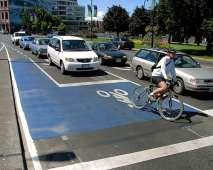
10 Average Daily Traffic Volume. 11/8/2012 No national standards; different State and local guidelines 2002 Review of North American and European guidelines Shared roads: low volumes/speeds Wide curb lanes: moderate volumes/speeds Bike lanes: higher volumes/speeds Separate path: special case 12,000 10,000 8,000 6,000 4,000 2, th Percentile Speed (mph) Normal lane Wide lane Bike lane or shoulder Facility selection is essentially a State/local policy decision Based on several factors: Road functional class and existing conditions Road cross section Traffic volumes and speeds Traffic mix and characteristics Driveway and access points Topography Existing and proposed land uses Expected users Facility cost 10

11 Facility type Shared lanes Wide curb lanes Marked shared lanes Paved shoulders Best use Minor roads w/ low volumes Motor vehicle design speed Traffic volume Intended use Other considerations Varies < 1,000 vpd Rural roads, or neighborhood and local streets Major roads > 25 mph > 3,000 vpd Arterials and collectors Space constrained with narrow lanes Speed limit 35 mph Variable Collectors and minor arterials Rural highways mph Variable Inter-city highways Bike lanes Major roads > 25 mph Speed differential is more important Bicycle boulevards Shared use paths Local roads with low volumes and speeds Speed limit 25 mph, speed differential < 15 mph Arterials and collectors < 3,000 vpd Residential roadways Linear corridors - - Separate path for bicyclists Alternative to busier roads Next three options are more desired High parking turnover Width depends on adjacent traffic Analyze intersection conflicts Grid network, avoid using frequent bike stops Path crossings Use of sidewalks for bicycle travel is unsatisfactory Conflicts are minor on residential streets Operating width 4 feet minimum for exclusive or preferential treatment 5 feet or more is desirable if there is a mix of traffic volumes and speeds, presence of buses and trucks Does not include shy distance Additional width for steep grades Min. 1.2 m (48 in) Desired 1.5 m (60 in) 11

12 Typically ride on right side of roadway on two-way roads Lateral position is determined by speed and usable width Obey stop and yield signs and rules Yield when changing lanes Overtake other vehicles on the left, except when Riding on a bike lane The vehicle to be overtaken is turning left Some states allow to pass on right when it is safe Approach intersections in the rightmost lane Several options for turning left at intersections Regular lane with no special bicycle provisions Wide curb lanes Roads with shared lane markings Roads with paved shoulders 12

 Caution with lane width 16 feet, cars can perceive it as two practical lanes Can often be installed by narrowing inside lane Not particularly attractive")
13 Roads with very low to low traffic volume and speeds 55 mph Travel Lane width (no shoulder is available for bicycles) 12 feet if no shoulder 14 feet min. desirable 15 feet on steep grades Paved shoulder width 4 feet min. desirable 5 feet min. in front of guardrails, curbs, or other roadside barriers Wider shoulders desired on roads with speeds > 50 mph Use where inadequate width exists for bike lane or shoulder (Width: feet) Caution with lane width 16 feet, cars can perceive it as two practical lanes Can often be installed by narrowing inside lane Not particularly attractive to bicyclists Inside travel lane Wide curb lane 3.6 m (12 ft) 4.2 m (14 ft) min. of usable lane width 13


14 Assist bicyclists with lateral positioning in a shared lane with on-street parallel parking in order to reduce the chance of a bicyclist s impacting the open door of a parked vehicle Assist bicyclists with lateral positioning in lanes that are too narrow for a motor vehicle and a bicycle to travel side by side within the same traffic lane, Alert road users of the lateral location bicyclists are likely to occupy within the traveled way, Encourage safe passing of bicyclists by motorists, and Reduce the incidence of wrong-way bicycling. Shall not be used on shoulders or in designated bicycle lanes. Street with on-street parallel parking Centers of the markings should be located at least 11 feet from the face of the curb, or from the edge of the pavement where there is no curb. Street without on-street parking and outside travel lane that is less than 14 feet wide Centers of the markings should be located at least 4 feet from the face of the curb, or from the edge of the pavement where there is no curb. If used, the Shared Lane Marking should be placed immediately after an intersection and spaced at intervals not greater than 250 feet thereafter. 14

 Wider shoulder on roads with speeds > 50 mph, with heavy truck traffic, or presence of obstructions 1.")
15 may be used on roadways where no bicycle lanes or adjacent shoulders usable by bicyclists are present and where travel lanes are too narrow for bicyclists and motor vehicles to operate side by side. The R4-11 sign may be used in locations where it is important to inform road users that bicyclists might occupy the travel lane. The Uniform Vehicle Code defines a substandard width lane as a lane that is too narrow for a bicycle and a vehicle to travel safely side by side within the same lane. Min. shoulder width: 4 feet (additional foot in front of guardrail, curb, or other objects) Wider shoulder on roads with speeds > 50 mph, with heavy truck traffic, or presence of obstructions 1.2 m (4 ft) min.* 3.6 m (12 ft) 3.6 m (12 ft) 1.2 m (4 ft) min.* * Min 1.5 m (5 ft) from face of guardrail, curb or other roadside barrier 15


16 No curb and gutter: 4 feet minimum If on-street parking present: 5 feet minimum With curb and gutter: 5 feet minimum (3 feet min. rideable surface, not including gutter pan) Parking permitted but not striped: 11 feet total with no curb; 12 feet total with curb 5 feet (1.5m) min. 7-8 ft 5-7 ft 7-8 ft 16
17 17
 spacing")


18 * max 150 mm (6-inch) spacing * Direction Direction Direction of travel of travel of travel A B C AVOID THIS! (rumble strips in bike lane) 18

19 Longitudinal pavement markings shall be used to define bicycle lanes. If used, bicycle lane word, symbol, and/or arrow markings should be placed at the beginning of a bicycle lane and at periodic intervals along the bicycle lane based on engineering judgment. The sign and supplementary plaques shall be used only in conjunction with marked bicycle lanes. If used, should be located in advance of the upstream end of the bicycle lane, at the downstream end of the bicycle lane, and at periodic intervals along the bicycle lane as determined by engineering judgment based on prevailing speed of bicycle and other traffic, block length, distances from adjacent intersections, and other considerations. 19


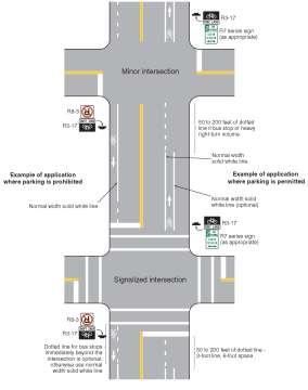
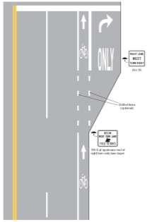
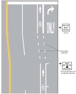
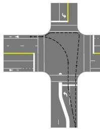
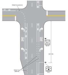
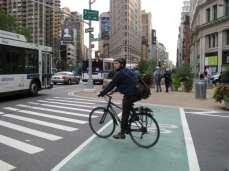
20 In locations where the roadway width does not allow two bike lanes Intersections provide a challenge from conflicts between right-turning vehicles and through-moving bicyclists. A through bicycle lane shall not be positioned to the right of a right-turn only lane or to the left of a left- turn only lane. 20

21 21


22 Multiple turn lanes are problems for bicyclists Should be avoided Loop detectors should be provided for bicyclists at intersections 22


23 Design or modify ramps to terminate closer to 90 Cross high-speed ramps in areas of good visibility Cross ramps at right angle 23


24 Inside radius = 9 m (30 ft) min. Bike Lanes - Interchanges Approximate angle 15 Bike lanes shall not be provided on the circular roadway 24

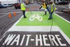
25 Colorized pavement Bike boxes Contra-flow bike lanes Buffered bike lanes Cycle tracks 25

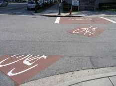
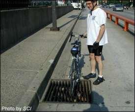
26 Photo by SCI 26


27 Reduces right-hook threat Assists left-turning bicyclists Alerts motorists to presence of bicyclists Eliminates RTOR 27

28 May provide more direct access in both directions Consider physical separation Must provide legal signing and striping Contraflow Lanes Hazard Issue Primary Field of View Primary Field of View Two-way bike lane 28


29 Provide more bicyclist comfort Provides more maneuvering space to avoid obstacles Can be placed on roads with high speeds or volumes parking turnover volume of heavy vehicles 29


30 Used on high-volume, highspeed roads with few turning conflicts Appealing to a wide range of bicyclists Reduces dooring risk Requires a large amount of space Requires investment at intersections Physical area separated from the road Typical widths: feet Diverse user mix Not always the best transportation corridors Grades <5% for long distances Centerline stripe is recommended 30
31 31

32 Shared Path Grade Separation Only place one in the center Should be spaced 60 inches apart 32

33 Bike Route Guide signs may be provided along designated bicycle routes to inform bicyclists of bicycle route direction changes and to confirm route direction, distance, and destination. The Bicycle Route sign shall contain a route designation and shall have a green background with a retroreflectorized white legend and border. Integral to planning: an inventory of existing conditions Documenting existing conditions Comparing alternatives Identifying design configurations for improvements to existing roads Prioritizing/programming improvements Creating bicycle maps How suitable are certain roads for bicycling? Bicycle Compatibility Index Bicycle Level of Service Bicycle Intersection Safety Index
34 Product of 1998 FHWA study Evaluates the capability of specific roadways to accommodate both motorists and bicyclists Developed for urban and suburban roadway segments Allows evaluation of existing facilities to determine what improvements may be required Can also determine the geometric and operational requirements for new facilities Empirical model that uses: Presence and width of shoulder or bike lane Vehicle traffic volume and speed Presence of vehicle parking Type of roadside development 2-67 Incorporates variables which bicyclists typically use to assess the "bicycle friendliness" of a roadway BCI = BL BLW CLW CLV OLV SPD PKG AREA + AF 34
35 BCI Score BLOS Bicycle Compatibility Level 1.50 A Extremely High B Very High C Moderately High D Moderately Low E Very Low > 5.30 F Extremely Low BCI = BL BLW CLW CLV OLV SPD PKG AREA + AF BL = presence of a bicycle lane or paved shoulder > 0.9 m; No = 0, Yes = 1 BLW = bicycle lane (or paved shoulder) width; m CLW = curb lane width; m CLV = curb lane volume, vphpd OLV = other lane(s) volume - same direction, vph SPD = 85th percentile speed of traffic, km/h 35
36 BCI = BL BLW CLW CLV OLV SPD PKG AREA + AF PKG = presence of a parking lane with more than 30% occupancy; No = 0, Yes = 1 AREA = type of roadside development; Residential = 1, Other type = 0 AF = f(t) + f(p) + f(rt); adjustment factors for large truck volumes, on-street parking turnover, and volume of right-turning vehicles, respectively 1 - Large trucks = all vehicles with 6 or more tires 2 Includes total number of right turns into driveways or minor intersections along the road 36

37 Multilane arterial road (2 lanes per direction) Curb lane width is 4.3 m AADT on this segment is 15,000 vpd Posted speed limit is 65 km/h 85th percentile speed during the peak-hour is 75 km/h Development primarily consists of retail centers and commercial businesses No on-street parking Large truck volume is 5 % Approximately 10 % of the vehicles turn right into driveways or minor streets Assume K = 0.10, D = 0.55 PHV = AADT x K x D = 15,000 x 0.1 x 0.55 = 825 vph CLV = PHV / N = 825 / 2 = 413 vph OLV = PHV - CLV = = 412 vph Assume T (truck % in curb lane) = 0.8 CLTV = PHV x HV x T = 825 x 0.05 x 0.8 = 33 tvph RTV = PHV x R = 825 x 0.1 = 83 vph AF = = 0.3 Ft = 0.3 Fp = 0.0 Frt =
 + (0.506 x 0) (0.264 x 0) + 0.3 = 4.")
38 BCI = BL BLW CLW CLV OLV SPD PKG AREA + AF = 3.67 (0.966 x 0) (0.41 x 0) (0.498 x 4.3) + (0.002 x 413) + ( x 412) + (0.022 x 75) + (0.506 x 0) (0.264 x 0) = 4.47 LOS E, Very Low Compatibility Developed in 1996 by Sprinkle Consulting and University of Florida Empirical model that uses: Road width Presence and width of shoulder or bike lane Vehicle traffic volume, speed, and type Pavement surface condition Presence of vehicle parking
39 Measures on-street conditions (not trails), for midblock cross-sections (not intersections) Research based on perception of comfort, safety for range of adults Both based on roadway corridor cross-sections and traffic conditions Numeric result, grade ranges A (best) to F (worst) Published in Transportation Research Record 1578 Bicycle LOS Level of Service BLOS Score A 1.5 B > 1.5 AND 2.5 C > 2.5 AND 3.5 D > 3.5 AND 4.5 E > 4.5 AND 5.5 F >
 / (4 x PHF) ADT D Kd PHF L = average daily traffic on the segment = Directional factor = peak to daily factor = Peak")
40 Bicycle LOS = ln (Vol 15 /L) SP t ( HV) (1/PR 5 ) (W e ) Vol 15 = volume of directional traffic in 15 minute period = (ADT x D x Kd ) / (4 x PHF) ADT D Kd PHF L = average daily traffic on the segment = Directional factor = peak to daily factor = Peak Hour Factor = total number of through lanes SP t = effective speed limit = ln(sp P -20) SP P HV PR 5 = Posted speed limit = percentage of heavy vehicles = FHWA s five point surface condition rating 40
 and Wl = 0 = Wv + Wl (1-2 x %OSPA) and Wl > 0 & Wps= 0 = Wv + Wl - 2 (10 x %OSPA) and Wl > 0 & Wps> 0 and bikelane")
41 Bicycle LOS = ln (Vol 15 /L) SP t ( HV) (1/PC 5 ) (W e ) W e = Average effective width of outside through lane; W t = Wv - (10 ft x %OSPA) and Wl = 0 = Wv + Wl (1-2 x %OSPA) and Wl > 0 & Wps= 0 = Wv + Wl - 2 (10 x %OSPA) and Wl > 0 & Wps> 0 and bikelane exists = total width of outside lane and shoulder/parking OSPA = % of segment with occupied on-street parking W l = width from outside lane stripe to pavement edge Wps = width of pavement striped for on-street parking Wv = effective width as function of traffic volume = Wt, if ADT > 4,000 = Wt ( x ADT), if ADT 4,000 vpd and if the street/ road is undivided and unstriped Retrofitting bike lanes on existing streets: Reduction of travel lane width Reduction in the number of travel lanes Removal, narrowing, or reconfiguration of parking Other design options 41

 Candidate")


42 Can be implemented up to 20,000 ADT with little traffic diversion Crash reductions (CMF 0.71 for all crashes) Candidate roads: Moderate traffic volumes Popular cycle routes Main Streets Streets with safety issues Historic streets 4 to 3 lanes 4 to 2 lanes 42

 W t")

43 Bicycle Level of Service Examples Bicycle LOS - Before ADT = 13,500 vpd Assume: K d = 0.10 D = 0.50 PHF = 1.00 L n = 2 PC 5 = 4 (good pavement) W t = 12 ft W l = 0 ft SP p = 30 mph 12' 12' 12' 12' BLOS Evaluation: LOS score Category 3.58 D 48' 43
44 Bicycle LOS - After ADT = 13,500 vpd Assume: K d = 0.10 D = 0.50 PHF = 1.00 L n = 1 PC 5 = 4 (good pavement) W t = 17 ft W l = 5 ft SP p = 30 mph 5' 12' 14' 12' 5' 48' BLOS Evaluation: LOS score Category 2.07 B Extra space benefits cyclists Striping particularly helpful in improving BLOS 44
45 Model is not used to predict bicycle crashes; it is a suitability model Model is based on the perceptions of safety of a typical bicyclist Model applies to roadway segments, not intersections Model represents the typical conditions along a roadway segment (averages, not anomalies) Driveways were not a significant factor Slope is not included in the model Signage is not included in the model New facility types cannot be evaluated (e.g., shared lane markings, cycle tracks, etc.) Develop in 2005 in the State of Florida Rate entire arterial sections Based on perceptions of bicyclists about level of safety, comfort, and travel efficiency (i.e., delay) provided by the bicycling environment Survey of 63 participants 45
46 Arterial BLOS = AvSegLOS NumUnsigpm AvSegLOS = distance-weighted average segment bicycle LOS along the facility NumUnsigpm = the number of unsignalized intersections per mile along the facility Develop in 2002 in the State of Florida LOS for bicycle through movements at intersections Based on the safety and comfort perception of 60 bicyclists riding through signalized intersections BLOS primary factors Roadway traffic volume Total width of outside through lane Intersection crossing distance 46
47 TM Int BLOS = Wt CD (Vol15 / L) TM Int BLOS = perceived hazard of shared-roadway environment through the intersection Wt = total width of outside through lane and bike lane (if present) CD = crossing distance, the width of the side street (including auxiliary lanes and median) Vol15 = volume of directional traffic during a 15- minute time period L = total number of through lanes on the approach to the intersection Bicycle LOS Real-time roadway segment ratings Bicyclists in real traffic situations Bicyclists could evaluate pavement; pavement condition was significant and used in model Bicycle Compatibility Index Bicyclists watched & rated video clips Most of the same factors identified as important Right-turn volumes were significant and included in model Parking turnover was significant and included in the model 47

48 Developed by FHWA in 2007 Allows prioritization of intersections with respect to pedestrian and bicycle safety Evaluates each approach leg for a group of intersections Bike ISI gives relative rankings according to potential bicyclist safety Selects sites with highest ISI values and conduct more in-depth safety evaluation 48
49 FOR THROUGH BICYCLE MOVEMENTS MAINADT =main street ADT, in 1,000s MAINHISPD = main street speed limit 35 mph, 1=yes TURNVEH= presence of turning vehicle traffic across the path of TH bicyclists, 1 = yes RTLANES = right-turn lanes on main street BL = bike lane indicator, 1=yes NOBL = no bike lane indicator, 1=yes CROSSADT = cross street ADT, in 1,000s SIGNAL = traffic signal indicator, 1=yes PARKING = on-street parking on main street indicator, 1=yes Source: 2007 FHWA FOR RIGHT-TURN BICYCLE MOVEMENTS MAINADT =main street ADT, in 1,000s RTCROSS = lanes for cyclists to cross to make a right turn CROSSLNS = through lanes on cross streets PARKING = on-street parking on main street indicator, 1=yes Source: 2007 FHWA 49

50 FOR LEFT-TURN BICYCLE MOVEMENTS MAINADT =main street ADT, in 1,000s SIGNAL = traffic signal indicator, 1=yes MAINHISPD = main street speed limit 35 mph, 1=yes LTCROSS = lanes for cyclists to cross to make a left turn BL = bike lane indicator, 1=yes NOBL = no bike lane indicator, 1=yes PARKING = on-street parking on main street indicator, 1=yes Source: 2007 FHWA Lesson Summary 50
Chapter 4 On-Road Bikeways
 Chapter 4: 4-1.0 Introduction On-Road Bikeways This chapter provides guidelines to help select and design safe on-road bikeways. On-road bikeways include bicycle lanes, shared lanes, shoulders, and wide
Planning Guidance in the 2012 AASHTO Bike Guide
 Planning Guidance in the 2012 AASHTO Bike Guide Presentation by: RJ Eldridge Peter Lagerwey August 22, 2012 WEBINAR 2: PLANNING GUIDANCE IN THE 2012 AASHTO BIKE GUIDE Today s Webinar Significant Updates
Active Transportation Facility Glossary
 Active Transportation Facility Glossary This document defines different active transportation facilities and suggests appropriate corridor types. Click on a facility type to jump to its definition. Bike
appendix b BLOS: Bicycle Level of Service B.1 Background B.2 Bicycle Level of Service Model Winston-Salem Urban Area
 appendix b BLOS: B.1 Background Winston-Salem Urban Area Bicycle Level of Service Level of Service (LOS) is a framework that transportation professionals use to describe existing conditions (or suitability)
General Design Factors
 Chapter 3: 3-1.0 Introduction General Design Factors Mn/DOT s goals include encouraging and accommodating safe bicycling. From a design perspective, these goals are achieved by first having an understanding
Appendix 3 Roadway and Bike/Ped Design Standards
 Appendix 3 Roadway and Bike/Ped Design Standards OTO Transportation Plan 2040 4/20/2017 Page A3-1 Adopted Standards The adopted OTO Design Standards and Major Thoroughfare Plan are contained herein.
Finding a bicycle route that offers a high Level of Service in Adelaide
 Finding a bicycle route that offers a high Level of Service in Adelaide Sekhar School of Natural and Built Environment, University of South Australia 1 Introduction Many community planners and policy makers
RURAL HIGHWAY SHOULDERS THAT ACCOMMODATE BICYCLE AND PEDESTRIAN USE (TxDOT Project ) June 7, Presented by: Karen Dixon, Ph.D., P.E.
 June 7, Presented by: Karen Dixon, Ph.D., P.E.") RURAL HIGHWAY SHOULDERS THAT ACCOMMODATE BICYCLE AND PEDESTRIAN USE (TxDOT Project 0-6840) June 7, 2016 Presented by: Karen Dixon, Ph.D., P.E., TTI Team: Kay Fitzpatrick, Raul Avelar, & Subasish Das Project
RURAL HIGHWAY SHOULDERS THAT ACCOMMODATE BICYCLE AND PEDESTRIAN USE (TxDOT Project 0-6840) June 7, 2016 Presented by: Karen Dixon, Ph.D., P.E., TTI Team: Kay Fitzpatrick, Raul Avelar, & Subasish Das Project
Access Management in the Vicinity of Intersections
 Access Management in the Vicinity of Intersections FHWA-SA-10-002 Technical Summary Photo: Ralph Bentley (used with permission) 0 Access Management is: The design, implementation and management of entry
Designing On Road Bikeways
 Module B Learning Outcomes: Describe features of on road bikeways Select design criteria for on road bikeways in various contexts Bicycle Characteristics Height Handlebar 36 44 in Eye 60 in Operating 100
Bicycle Facilities Planning
 Bicycle Facilities Planning Overview Types of Cyclists Purpose for Riding Types of Facilities Bike Lanes Bicycle Boulevards Cycle Tracks Intersections Signals Signing and Marking Discussion Types of Bicyclists
Multimodal Analysis in the 2010 Highway Capacity Manual
 Multimodal Analysis in the 2010 Highway Capacity Manual It s not just cars anymore! Jamie Parks, AICP HCAT Conference May 9-10, 2011 Multimodal LOS in the 2010 HCM History and background Overview of methods
Off-road Trails. Guidance
 Off-road Trails Off-road trails are shared use paths located on an independent alignment that provide two-way travel for people walking, bicycling, and other non-motorized users. Trails specifically along
Broad Street Bicycle Boulevard Design Guidelines
 Broad Street Bicycle Boulevard Design Guidelines Building from the strategies introduced in the 2013 Bicycle Transportation Plan and community input received thus far, City Transportation Staff have identified
On Road Bikeways Part 1: Bicycle Lane Design
 On Road Bikeways Part 1: Bicycle Lane Design Presentation by: Nick Jackson Bill Schultheiss, P.E. September 04, 2012 FOLLOW THE CONVERSATION ON TWITTER Toole Design Group is live tweeting this webinar
Cycle Track Design Best Practices Cycle Track Sections
 Design Best Practices Sections It is along street segments where the separation and protection methods of cycle tracks offer more comfort than conventional bicycle lanes, and are more attractive to a wide
Who is Toole Design Group?
 2018 AASHTO Bike Guide Status Update NCHRP 15 60 Amalia Leighton Cody, PE, AICP & Kenneth Loen, PE Washington APWA October 4, 2018 Who is Toole Design Group? TDG is a full service engineering, planning
Section 9A.07 Meaning of Standard, Guidance, Option, and Support
 2012 Edition Page 895 PART 9. TRAFFIC CONTROLS FOR BICYCLE FACILITIES CHAPTER 9A. GENERAL Section 9A.01 Requirements for Bicyclist Traffic Control Devices 01 General information and definitions concerning
South Carolina Department of Transportation. Engineering Directive
 South Carolina Department of Transportation Engineering Directive Directive Number: ED-22 Effective: December 16, 2009 Subject: References: Purpose: This Directive Applies to: Considerations for Bicycle
Bicycle and Pedestrian Level of Service Measures
 Bicycle and Pedestrian Level of Service Measures June 5, 2003 Midwest Transportation Planning Conference Ed Barsotti League of Illinois Bicyclists 630-978-0583 ed@bikelib.org www.bikelib.org Outline Why
Access Location, Spacing, Turn Lanes, and Medians
 Design Manual Chapter 5 - Roadway Design 5L - Access Management 5L-3 Access Location, Spacing, Turn Lanes, and Medians This section addresses access location, spacing, turn lane and median needs, including
Figure 3B-1. Examples of Two-Lane, Two-Way Marking Applications
 Figure 3B-1. Examples of Two-Lane, Two-Way Marking Applications A - Typical two-lane, two-way marking with passing permitted in both directions B - Typical two-lane, two-way marking with no-passing zones
APPENDIX A: Complete Streets Checklist DRAFT NOVEMBER 2016
 APPENDIX A: Complete Streets Checklist DRAFT NOVEMBER 2016 Complete Streets Checklist MetroPlan Orlando s Complete Streets Checklist is an internal planning tool for staff to further implementation of
PBIC Webinar. How to Create a Bicycle Safety Action Plan: Planning for Safety [IMAGE] Oct. 2, 2014, 2 pm
![PBIC Webinar. How to Create a Bicycle Safety Action Plan: Planning for Safety [IMAGE] Oct. 2, 2014, 2 pm](/thumbs/86/93953441.jpg "PBIC Webinar. How to Create a Bicycle Safety Action Plan: Planning for Safety [IMAGE] Oct. 2, 2014, 2 pm") PBIC Webinar How to Create a Bicycle Safety Action Plan: Planning for Safety [IMAGE] Bill Schultheiss, Vice President, Toole Design Peter Lagerwey, Regional Director, Toole Design Oct. 2, 2014, 2 pm Today
PBIC Webinar How to Create a Bicycle Safety Action Plan: Planning for Safety [IMAGE] Bill Schultheiss, Vice President, Toole Design Peter Lagerwey, Regional Director, Toole Design Oct. 2, 2014, 2 pm Today
A Traffic Operations Method for Assessing Automobile and Bicycle Shared Roadways
 A Traffic Operations Method for Assessing Automobile and Bicycle Shared Roadways A Thesis Proposal By James A. Robertson Submitted to the Office of Graduate Studies Texas A&M University in partial fulfillment
Implementing Complete Streets in Ottawa. Project Delivery Process and Tools Complete Streets Forum 2015 October 1, 2015
 Implementing Complete Streets in Ottawa October 1, 2015 The Essentials Complete Streets Implementation Framework will become part of the routine delivery of City transportation projects Approach uses every
DEFINITIONS Activity Area - Advance Warning Area Advance Warning Sign Spacing Advisory Speed Approach Sight Distance Attended Work Space
 DEFINITIONS Activity Area - that part of a TTC zone activity area where the work actually takes place. It consists of the work space, traffic space and one or more buffer spaces. Advance Warning Area -
REGIONAL BICYCLE AND PEDESTRIAN DESIGN GUIDELINES
 REGIONAL BICYCLE AND PEDESTRIAN DESIGN GUIDELINES November 16, 2011 Deb Humphreys North Central Texas Council of Governments Bicycle and Pedestrian Advisory Committee Snapshot of the Guide 1. Introduction
NJDOT Complete Streets Checklist
 Background The New Jersey Department of Transportation s Complete Streets Policy promotes a comprehensive, integrated, connected multi-modal network by providing connections to bicycling and walking trip
5. RUNNINGWAY GUIDELINES
 5. RUNNINGWAY GUIDELINES These guidelines should be considered collectively when making runningway decisions. A runningway is the linear component of the transit system that forms the right-of-way reserved
TRAFFIC CALMING GUIDE FOR TORONTO CITY OF TORONTO TRANSPORTATION SERVICES DIVISION
 TRAFFIC CALMING GUIDE FOR TORONTO CITY OF TORONTO TRANSPORTATION SERVICES DIVISION CITY OF TORONTO TRANSPORTATION SERVICES DIVISION 2016 TRAFFIC CALMING GUIDE FOR TORONTO TABLE OF CONTENTS Introduction
Chapter 3 DESIGN SPECIFICATIONS
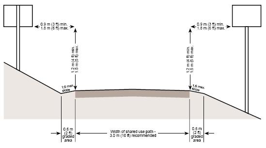
 Brampton PathWays Planning and Design Guidelines 27 Chapter 3 DESIGN SPECIFICATIONS 3.1 CLASS 1 MULTI-USE PATH Off-road multi-use trails are the backbone of the Brampton PathWays Network. They are typically
Bowman-Melton Associates, Inc. june 2011
 2011 dallas bike plan ADDENDUM Bowman-Melton Associates, Inc. Complete Streets Initiative Design and policy guidance june 2011 2 2011 Dallas Bike Plan Complete Streets Initiative Design and Policy Guidance
Acknowledgements. Mr. David Nicol 3/23/2012. Daniel Camacho, P.E. Highway Engineer Federal Highway Administration Puerto Rico Division
 Daniel Camacho, P.E. Highway Engineer Federal Highway Administration Puerto Rico Division Acknowledgements Mr. David Nicol Director, FHWA Office of Safety FHWA Office of Safety http://safety.fhwa.dot.gov/provencountermeasures/
CHAPTER 2G. PREFERENTIAL AND MANAGED LANE SIGNS
 2011 Edition - Revision 2 Page 275 Section 2G.01 Scope CHAPTER 2G. PREFERENTIAL AND MANAGED LANE SIGNS 01 Preferential lanes are lanes designated for special traffic uses such as high-occupancy vehicles
Section 1 Project Description
 Section 1 Project Description 1 1.0 Introduction The Fremont Recreational Pathway ( or Path) is a collaborative effort of Summit and Lake Counties, Colorado (Counties), and the Climax Molybdenum Company
This Chapter sets forth the minimum design, technical criteria and specifications to be used in the preparation of all roadway plans.
 4.1 GENERAL This Chapter sets forth the minimum design, technical criteria and specifications to be used in the preparation of all roadway plans. These Roadway Standards are for new construction and modification
(This page left intentionally blank)
") (This page left intentionally blank) 2011 Edition- Revision 2 Page 813 CHAPTER 9A. GENERAL Section 9A.01 Requirements for Bicyclist Traffic Control Devices 01 General information and definitions concerning
(This page left intentionally blank) 2011 Edition- Revision 2 Page 813 CHAPTER 9A. GENERAL Section 9A.01 Requirements for Bicyclist Traffic Control Devices 01 General information and definitions concerning
WYDOT DESIGN GUIDES. Guide for. Non-NHS State Highways
 WYDOT DESIGN GUIDES Guide for Non-NHS State Highways 2014 GUIDE FOR Non-NATIONAL HIGHWAY SYSTEM (Non-NHS) STATE HIGHWAYS PRESERVATION REHABILITATION RECONSTRUCTION INTRODUCTION This Guide is directed to
Multimodal Design Guidance. October 23, 2018 ITE Fall Meeting
 Multimodal Design Guidance October 23, 2018 ITE Fall Meeting Introductions Jessica Wilson TDOT Multimodal Division Office of Multimodal Planning Program Supervisor Jessica.L.Wilson@tn.gov Ali Hangul TDOT
WYDOT DESIGN GUIDES. Guide for. NHS Arterial (Non-Interstate)
") WYDOT DESIGN GUIDES Guide for NHS Arterial (Non-Interstate) 2014 GUIDE FOR NATIONAL HIGHWAY SYSTEM (NHS) HIGHWAYS (NHS ARTERIALS, Non-Interstate) PRESERVATION REHABILITATION RECONSTRUCTION INTRODUCTION
WYDOT DESIGN GUIDES Guide for NHS Arterial (Non-Interstate) 2014 GUIDE FOR NATIONAL HIGHWAY SYSTEM (NHS) HIGHWAYS (NHS ARTERIALS, Non-Interstate) PRESERVATION REHABILITATION RECONSTRUCTION INTRODUCTION
Physical Implications of Complete Streets Policies
 Presentation Overview Physical Implications of Complete Norm Cox, ASLA, LLA Landscape Architect Ann Arbor, Michigan, 10:45 to Noon What Are Complete Streets? What Matters to Bicyclists and Pedestrians
On-Street Bicycle Facilities
 On-Street Bicycle Facilities A. General 12B-3 Design Manual Chapter 12 - Sidewalks and Bicycle Facilities 12B - Bicycle Facilities Cyclists have similar access and mobility needs as other transportation
CHAPTER 1 STANDARD PRACTICES
 CHAPTER 1 STANDARD PRACTICES OBJECTIVES 1) Functions and Limitations 2) Standardization of Application 3) Materials 4) Colors 5) Widths and Patterns of Longitudinal Pavement Marking Lines 6) General Principles
DRAFT Montgomery County Bicycle Master Plan Design Toolkit
 DRAFT Montgomery County Bicycle Master Plan Design Toolkit Fall 2016 Sidepaths Sidepaths are shared use paths located parallel to and within the road right-of-way providing twoway travel for walking, bicycling,
CHAPTER 6H. TYPICAL APPLICATIONS
 Section 6H.01 Typical Applications Support: CHAPTER 6H. TYPICAL APPLICATIONS Chapter 6G contains discussions of typical temporary traffic control activities. Chapter 6H presents typical applications for
BICYCLE LEVEL OF SERVICE for URBAN STREETS. Prepared by Ben Matters and Mike Cechvala. 4/16/14 Page 1
 BICYCLE LEVEL OF SERVICE for URBAN STREETS Prepared by Ben Matters and Mike Cechvala 4/16/14 Page 1 Introduction The methodology used for the Bicycle (BLOS) analysis is from the Highway Capacity Manual
Appendix A: Crosswalk Policy
 Appendix A: Crosswalk Policy Appendix A: Crosswalk Policy Introduction This citywide Crosswalk Policy is aimed at improving pedestrian safety and enhancing pedestrian mobility by providing a framework
2.0 LANE WIDTHS GUIDELINE
 2.0 LANE WIDTHS GUIDELINE Road Engineering Design Guidelines Version 2.0.1 May 2018 City of Toronto, Transportation Services City of Toronto Page 0 Background In early 2014, Transportation Services initiated
10.0 CURB EXTENSIONS GUIDELINE
 10.0 CURB EXTENSIONS GUIDELINE Road Engineering Design Guidelines Version 1.0 March 2017 City of Toronto, Transportation Services City of Toronto Page 0 Background In early 2014, Transportation Services
MUTCD Part 6G: Type of Temporary Traffic Control Zone Activities
 MUTCD Part 6G: Type of Temporary Traffic Control Zone Activities 6G.01 Typical Applications Each temporary traffic control (TTC) zone is different. Many variables, such as location of work, highway type,
FEDERAL HIGHWAY ADMINISTRATION APPLICATION
 FEDERAL HIGHWAY ADMINISTRATION APPLICATION REQUEST FOR PERMISSION TO EXPERIMENT WITH A BICYCLE BOX INTERSECTION TREATMENT Submitted by: City of Columbus Department of Public Service Date: June 26, 2009
Bicycle and Pedestrian Connectivity Study. Old Colony Planning Council
 Bicycle and Pedestrian Connectivity Study Old Colony Planning Council Outline Why consider bike/peds in road designs? Why are measures needed? Connecting Land Use with Transportation Evaluation Tools:
ACTIVE TRANSPORTATION
 ACTIVE TRANSPORTATION Mobility 2040 Supported Goals Improve the availability of transportation options for people and goods. Support travel efficiency measures and system enhancements targeted at congestion
Multimodal Through Corridors and Placemaking Corridors
 68 Multimodal Through Corridors and Placemaking Corridors Corridors have different functions in a region. Some corridors are used to get smoothly and rapidly through a region or to get quickly to major
FHWA Bikeway Selection Guide
 FHWA Bikeway Selection Guide Tamara Redmon Federal Highway Administration Bill Schultheiss Toole Design Lauren Blackburn VHB March 26, 2019 PBIC Webinar pedbikeinfo.org @pedbikeinfo Housekeeping Problems
CHAPTER 3A. GENERAL PAGE CHAPTER 3B. PAVEMENT AND CURB MARKINGS PAGE
 Virginia Supplement to the 2009 MUTCD Revision 1 Page TC-3-1 PART 3. MARKINGS CHAPTER 3A. GENERAL PAGE Section 3A.01 Functions and Limitations Section 3A.02 Standardization of Application Section 3A.03
TRAFFIC CONTROLS FOR BICYCLE FACILITIES
 Part 9. TRAFFIC CONTROLS FOR BICYCLE FACILITIES TABLE OF CONTENTS Chapter 9A. GENERAL Page Section 9A.1 Requirements for Bicyclist Traffic Control Devices............................. 9A-1 9A.2 Scope.................................................................
Safety Impacts: Presentation Overview
 Safety Impacts: Presentation Overview The #1 Theme How Access Management Improves Safety Conflict Points The Science of Access Management By Treatment Studies Themes for Texas Access Management Improve
City of Wayzata Comprehensive Plan 2030 Transportation Chapter: Appendix A
 A1. Functional Classification Table A-1 illustrates the Metropolitan Council s detailed criteria established for the functional classification of roadways within the Twin Cities Metropolitan Area. Table
SECTION 1 - TRAFFIC PLANNING
 SECTION 1 - TRAFFIC PLANNING 1.1 TRAFFIC OPERATIONS 1.1.1 Roadway Functional Classification The Multnomah County Comprehensive Framework Plan s Policy 34: Trafficways and the Functional Classification
Connecting cyclists to work. Syracuse Metropolitan Transportation Council
 Connecting cyclists to work Syracuse Metropolitan Transportation Council Overview Prepared at request: NYS Department of Transportation (NYSDOT) Project Achievements Target group Purpose Process Recommendations
Report. Typical Sections. City of Middleton, WI
 Report Typical Sections City of Middleton, WI December 2006 Report for City of Middleton, Wisconsin Typical Sections repared by: Traffic Associates LLC and STRAND ASSOCIATES, INC. 910 West Wingra Drive
Road Diets: Reconfiguring Streets for Multi-Modal Travel
 Road Diets: Reconfiguring Streets for Multi-Modal Travel Tom Grant, P.E., PTOE What is a Road Diet? Reconfiguration of travel lanes to benefit all roadway users (i.e., Complete Street) Reclaiming the space
Public Information Centre
 WELCOME Public Information Centre Father Tobin Road Lougheed Middle School - Library Wednesday November 7, 2012 7:00 p.m.to 9:00 p.m. Please sign in Neighbourhood Traffic Calming Guide Background The City
INTRODUCTION THOROUGHFARE SYSTEM CLASSIFICATIONS
 INTRODUCTION The thoroughfare plan will assist public officials in the development of a specialized system for efficient and safe movement of vehicular traffic while minimizing potential conflicts with
INDEX. Geometric Design Guide for Canadian Roads INDEX
 Acceleration lane, see Lanes, Acceleration Access, 8.1 Access Management and Functional Classification 8.2 Access Management by Design Classification 8.3 Access Configuration 8.4 Building Set-Back Guidelines
CORE MPO Non-motorized Transportation Plan. Appendix D
 Appendix D Technical Report on Methodology of Bikeway Conditions Analysis: Bicycle Level of Service Model, version 2, for Segments This page is intentionally left blank. Methodology of Bikeway Conditions
DESIGN GUIDANCE 1. INTRODUCTION 2. PRIORITIZED STATEWIDE BICYCLE NETWORK
 DESIGN GUIDANCE 1 1. INTRODUCTION This document presents context sensitive guidance for the selection and maintenance of bikeway infrastructure along roadway facilities owned and maintained by NMDOT. The
OBJECTIVE: Improve safety by designing all bicycle facilities to the latest AASHTO bicycle guidelines and 2009 MUTCD Standards.
 DESIGN AND APPLICATION OF GUIDELINES AND STANDARDS The Citizen Advisory and Technical Advisory Committees identified improving safety by providing consistent bicycle facilities throughout the region as
DRAFT - CITY OF MEDFORD TRANSPORTATION SYSTEM PLAN Roadway Cross-Sections
 Roadway Cross-Sections Medford s roadway cross-section standards apply to new and reconstructed roads. The crosssections take into consideration roadway function and operational characteristics, including
MAG Town of Cave Creek Bike Study Task 6 Executive Summary and Regional Significance Report
 Page 1 MAG Town of Cave Creek Bike Study Task 6 Executive Summary and Regional Significance Report August 1, 2012 MAG Project #481 Page 2 Task 6 Executive Summary and Regional Significance Report Introduction
CURBSIDE ACTIVITY DESIGN
 5 CURBSIDE ACTIVITY DESIGN This chapter provides design guidance for separated bike lanes adjacent to curbside activities including parking, loading and bus stops. Typical configurations are presented
Driveway Design Criteria
 Design Manual Chapter 5 - Roadway Design 5L - Access Management 5L-4 Driveway Design Criteria A. General For efficient and safe operations, access drives and minor public street intersections can be improved
PART 9. TRAFFIC CONTROLS FOR BICYCLE FACILITIES TABLE OF CONTENTS
 2006 Edition Page TC9-1 PART 9. TRAFFIC CONTROLS FOR BICYCLE FACILITIES TABLE OF CONTENTS SECTIONS CHAPTER 9A. Section 9A.01 Section 9A.02 Section 9A.03 Section 9A.04 Section 9A.05 Section 9A.06 Section
Central Arkansas Regional Transportation Study Area ROADWAY DESIGN STANDARDS And Implementation Procedures
 Central Arkansas Regional Transportation Study Area ROADWAY DESIGN STANDARDS And Implementation Procedures These standards have been prepared for the use of all jurisdictions to incorporate into their
General References Definitions. (1) Design Guidance. (2) Supporting Information
 Design Guidance. (2) Supporting Information") Chapter 1240 Turning Roadways 1240.01 General 1240.02 References 1240.03 Definitions 1240.04 Turning Roadway Widths 1240.05 Documentation 1240.01 General The roadway on a curve may need to be widened to
Chapter 1240 Turning Roadways 1240.01 General 1240.02 References 1240.03 Definitions 1240.04 Turning Roadway Widths 1240.05 Documentation 1240.01 General The roadway on a curve may need to be widened to
Recommended Roadway Plan Section 2 - Land Development and Roadway Access
 Recommended Roadway Plan Section 2 - Land Development and Roadway Access SECTION 2 Land Development and Roadway Access 2.1 Land Use and Access Management The Federal Highway Administration (FHWA) defines
Highway Capacity and LOS. Reading Assignment: pgs
 Highway Capacity and LOS Reading Assignment: pgs. 170-200 We know from the previous section that traffic flows fairly well when Demand < Capacity. However, when demand approaches capacity, we begin to
CHAPTER 6H. TYPICAL APPLICATIONS
 2006 Edition Page 6H-1 CHAPTER 6H. TYPICAL APPLICATIONS Section 6H.01 Typical Applications Support: Whenever the acronym TTC is used in this Chapter, it refers to temporary traffic control. Standard: The
West Dimond Blvd Upgrade Jodhpur Street to Sand Lake Road
 West Dimond Blvd Jodhpur St to Sand Lake CSS Transportation Project Summary Municipality of Anchorage Project # 05 005 Project Manager: John Smith, P.E. (MOA PM&E) Project Administrator: Julie Makela,
Complete Streets Policy DAVID CRONIN, P.E., CITY ENGINEER
 Complete Streets Policy DAVID CRONIN, P.E., CITY ENGINEER Complete Streets City Commission adopted a Complete Streets policy in 2012 Complete Streets are road networks that are designed for all users:
Coquitlam Cross-town Bike Route Improving Bicycle Facilities in a Mature Suburban Environment
 Coquitlam Cross-town Bike Route Improving Bicycle Facilities in a Mature Suburban Environment Sarah Rocchi, Vice-President, Projects, Opus International Consultants (Main Presenter) Catherine Mohoruk,
Bicycle Boulevards and Neighborhood Greenways
 Bicycle Boulevards and Neighborhood Greenways Traffic Safety is Improving for Everyone 90 80 70 60 50 40 30 20 10 0 PORTLAND: TOTAL TRAFFIC FATALITIES 1986-2008 1986 1987 1988 1989 1990 1991 1992 1993
Geometric Design Tables
 Design Manual Chapter 5 - Roadway Design 5C - Geometric Design Criteria 5C-1 Geometric Design Tables A. General The following sections present two sets of design criteria tables - Preferred Roadway Elements
Section 3A.04 Colors. Section 3B.10 Approach Markings for Obstructions
 Section 3A.04 Colors Markings shall be yellow, white, red, or blue, or purple. The colors for markings shall conform to the standard highway colors. Black in conjunction with one of the above colors shall
G AT E WAY PLAN. Community BRIEFING KIT GATEWAY BIKE
 G AT E WAY PLAN GATEWAY BIKE Community BRIEFING KIT PLAN August 2016 TABLE OF CONTENTS INTRODUCTION... 1 THE BENEFITS OF A BIKEABLE COMMUNITY... 2 ECONOMY...2 SAFETY...3 HEALTH...3 HOUSEHOLD SPENDING...3
Why plan for bicycles?
 Local Bike Planning Basics: Products and Process Topics Ed Barsotti 630-978-0583 ed@rideillinois.org Why plan for bicycles? Why plan for bicycles? - Quality of life, popular - Economic development - Recreation
6.0 PEDESTRIAN AND BICYCLE FACILITIES 6.1 INTRODUCTION 6.2 BICYCLE DEMAND AND SUITABILITY Bicycle Demand
 6.0 PEDESTRIAN AND BICYCLE FACILITIES 6.1 INTRODUCTION Bicycle and pedestrian travel along and in the vicinity of the corridor is part of the vision of Somerset and Hunterdon counties and the integrated
International Journal of Mechanical Engineering and Technology (IJMET), ISSN 0976 INTERNATIONAL JOURNAL OF MECHANICAL ENGINEERING
, ISSN 0976 INTERNATIONAL JOURNAL OF MECHANICAL ENGINEERING") INTERNATIONAL JOURNAL OF MECHANICAL ENGINEERING AND TECHNOLOGY (IJMET) ISSN 0976 6340 (Print) ISSN 0976 6359 (Online) Volume 4, Issue 5, September - October (2013), pp. 244-249 IAEME: www.iaeme.com/ijmet.asp
INTERNATIONAL JOURNAL OF MECHANICAL ENGINEERING AND TECHNOLOGY (IJMET) ISSN 0976 6340 (Print) ISSN 0976 6359 (Online) Volume 4, Issue 5, September - October (2013), pp. 244-249 IAEME: www.iaeme.com/ijmet.asp
DRAFT. Scholls Ferry Road Conceptual Design Plan Technical Memorandum Multi-Modal Examples. Multnomah County 1600 SE 190th Avenue Portland, OR 97233
 Technical Memorandum Multi-Modal Examples Prepared for 1600 SE 190th Avenue Portland, OR 97233 December 2008 CITATION This project is partially funded by a grant from the Transportation and Growth Management
Proven Safety Countermeasures. FHWA Office of Safety January 12, :00 p.m. to 2:00 p.m. Eastern Time
 Proven Safety Countermeasures FHWA Office of Safety January 12, 2012 1:00 p.m. to 2:00 p.m. Eastern Time Introduction and Background While States should still be considering the application of all of the
Small Town & Rural Multimodal Networks
 Small Town & Rural Multimodal Networks Fred Young, PLA Andrea Clinkscales, AICP, PMP Alta Planning + Design Funding Partners Project Team Existing Design Guidance AASHTO Flexibility Guide 2004 AASHTO Bike
Guidance. ATTACHMENT F: Draft Additional Pages for Bicycle Facility Design Toolkit Separated Bike Lanes: Two-Way to One-Way Transitions
 ATTACHMENT F: Draft Additional Pages for Bicycle Facility Design Toolkit Separated Bike Lanes: Two-Way to One-Way Transitions This treatment provides a transition from two-way separated bike lanes to one-way
APPENDIX D LEVEL OF TRAFFIC STRESS METHODOLOGY
 APPENDIX D LEVEL OF TRAFFIC STRESS METHODOLOGY 01 WHAT IS LEVEL OF TRAFFIC STRESS? When people bicycle on roadways, they encounter varying levels of stress from traffic. A quiet residential street with
Classification Criteria
 SCHEDULE D TO RECOMMENDED OFFICIAL PLAN AMENDMENT NO. 40 SCHEDULE C-4 Road Criteria Criteria Traffic Service Objective Land Service/Access Typical Daily Traffic Volume Flow characteristics Travel Speed
INDOT Complete Streets Guideline & Policy
 INDOT Complete Streets Guideline & Policy INTRODUCTION The Complete Streets guidelines build upon multiple efforts and promote a multimodal transportation system that is integrated and sustains land use
9.1 FUNCTIONAL HIGHWAY SYSTEMS IN URBANIZED AREAS Principal Arterial Interstate Principal Arterial Non-Interstate
 Greater Bozeman Area Transportation Plan (2007 Update) Chapter 9: Recommended Major Street Network & Roadway Typical Sections 9.1 FUNCTIONAL HIGHWAY SYSTEMS IN URBANIZED AREAS The discussion in this Chapter
Clackamas County Comprehensive Plan
 ROADWAYS The County s road system permits the movement of goods and people between communities and regions, using any of a variety of modes of travel. Roads provide access to virtually all property. They
Railroad-Highway Grade Crossing Analysis for Corridor Planning Projects
 Railroad-Highway Grade Crossing Analysis for Corridor Planning Projects Word Count: 4,305 Submission Date: August 1, 2015 Author: Adriana Rodriguez, E.I Assistant Engineer Parsons Brinckerhoff 1420 South