North Wenatchee Transportation Master Plan
|
|
|
- Zoe Bailey
- 5 years ago
- Views:
Transcription


1 North Wenatchee Transportation Master Plan xpanding Regional Mobility nhancing Community Connections Improving Business Access QR Code As Adopted February 2011
2
 establishes the blueprint for improving transportation safety and traffic flow in a manner that supports economic growth in the SR 285 corridor")


3 What is the North Wenatchee Transportation Master Plan? The North Wenatchee Transportation Master Plan (Plan) establishes the blueprint for improving transportation safety and traffic flow in a manner that supports economic growth in the SR 285 corridor and the Wenatchee Valley. It identifies improvement projects, programs, and policy direction to enhance the transportation function of the corridor to support land use plans and economic development. The Plan focuses on North Wenatchee Avenue between US 2 and 5th Street north of downtown Wenatchee. The goal of the North Wenatchee Transportation Master Plan is to identify and implement strategies to improve transportation safety, traffic flow, and connectivity while enhancing the environment for businesses and residents in the corridor and accommodating planned growth and development within the Valley. The Plan was prepared by the Wenatchee Valley Transportation Council (WVTC) which sets regional transportation policy and priorities for the greater Wenatchee Valley. The Plan will be incorporated as a major element of Confluence 2030, the Metropolitan Transportation Plan. State, regional, and local agencies also will incorporate elements of the Plan into their transportation plans and Transportation Improvement Programs to support implementation of the improvement projects, programs, and policies. North Wenatchee Transportation Master Plan 1
, and Link Transit.")


4 Who was involved in preparing the Plan? WVTC as the region s Metropolitan Planning rganizing (MP) led the development of the Plan. WVTC s membership includes the region s cities, counties, and ports, as well as the Washington State epartment of Transportation (W), and Link Transit. These are the major providers and operators of transportation services in the Wenatchee Valley. WVTC s xecutive Board provided overall direction for the study. A project Steering Committee and Corridor Advisory Team were established at the outset of the planning process to guide development of the Plan. The Steering Committee and Corridor Advisory Team provided input on study issues, technical analyses, evaluation criteria, improvement strategies, and final recommendations. Steering Committee WVTC Staff City of Wenatchee Public Works epartment Planning epartment Police epartment Fire epartment Planning Commission Chelan County Public Works epartment Planning epartment Link Transit Corridor Advisory Team Business owners/managers Property wners Realtors Bicycle Advisory Board Port of Chelan Wenatchee owntown Association Chamber of Commerce Town Toyota Center Wenatchee Valley Medical Center Sunnyslope neighborhood Builders Washington State epartment of Transportation In addition to the more formal committees, the Plan incorporates input from the general public and other stakeholders. Input on corridor issues, types of solutions, selection criteria, and proposed improvements were obtained at two open houses and via the WVTC web site. A walking tour of the corridor was led by WVTC to allow stakeholders to experience the conditions and discuss potential improvement strategies. In addition, a drop-in session was held for business and property owners along the North Wenatchee Avenue to obtain input on the alternatives. 2 North Wenatchee Transportation Master Plan

5 What are the key issues addressed by the Plan? The Plan addresses a wide range of issues including transportation safety, traffic flow, freight mobility, transit service, pedestrian and bicycle travel, and accessibility to businesses. The project team identified existing issues in the corridor through analysis of technical data, field review of the corridor, and input from the Steering Committee, Corridor Advisory Team, and public. The team applied the regional travel demand forecasting model to provide insights into conditions 20 years in the future if no significant transportation improvements are made. The overarching issue is balancing the wide range of transportation functions that the existing North Wenatchee Avenue corridor serves, such as: Serving as one of only two regional access routes to/from Wenatchee including access to the hospital, state and regional parks, and downtown Wenatchee Providing access to retail and commercial businesses along North Wenatchee Avenue and immediately adjacent areas Serving truck access for fruit packing plants and other industrial and commercial uses Providing access to/from the Loop Trail,waterfront parks, and Town Toyota Center for a variety of travel modes Providing the spine for Link s Intercity regional transit service between Wenatchee and outlying communities and local transit service in North Wenatchee area Providing access to residential areas, parks, and schools in and adjacent to the highway corridor Serving these competing uses in one corridor has resulted in a range of specific issues that are projected to get substantially worse as the region continues to grow. Land Use/conomic Growth A primary function of a transportation system is to provide a means to connect between an origin and destination. The origin and destination can generally be tied to land use or activity such as residential, retail/commercial, industrial, recreational, institutional (e.g. schools, hospitals), and agricultural. Without adequate accessibility and connectivity, areas may become less desirable to live, work, shop, or recreate, which further reduces growth and economic development as envisioned in adopted plans. From that perspective, the Plan incorporates land use and economic development factors into the solutions. Some of the key issues related to land use and economic development include: Transportation safety and accessibility to businesses within the corridor Providing mobility through the corridor to connect with regional economic centers and institutional land uses Connectivity for various travel modes within the corridor to reduce the number of short auto trips Support a changing mix of the types and densities along different segments of the corridor North Wenatchee Avenue is home to a wide range of auto-oriented businesses that depend on the highway for access. North Wenatchee Transportation Master Plan 3


6 Traffic Flow Some of the most obvious issues in the North Wenatchee Avenue corridor are related to traffic flow and congestion. The public and stakeholders identified key issues at several intersections; these concerns were supported by technical analysis. Congestion and traffic flow issues at these locations result in traffic diverting from the corridor to parallel streets such as Western Avenue. They also result in difficulties for traffic entering or exiting businesses and side streets along the corridor. Key locations affected by poor traffic flow, traffic queues, and congestion include: North Wenatchee Avenue in the vicinity of Maiden Lane and orse Lake Road North Wenatchee Avenue at Miller Street and Maple Street awley Street at railroad crossing US 2/97 interchange with SR 285 and asy Street/ US 2 traffic signal Traffic flow in the vicinity of Maiden Lane was identified as a key issue. Transportation Safety North Wenatchee Avenue and its extension to US 2 experience a significant number of collisions each year. Many of the collisions can be related to the poor traffic flow and congestion which results in drivers making unsafe maneuvers or decisions. Important elements related to transportation safety that helped in defining the Plan include: Significant number of collisions at intersections related to congestion, traffic flows, and queues Collisions at mid-block locations such as driveways or in the center, two-way, left-turn lane Collisions resulting from changes in travel speeds as the corridor transitions from downtown Wenatchee to the freeway north of the Wenatchee River Conflicts between autos, trucks, and transit service Safety of pedestrians and bicyclists along North Wenatchee Avenue and traveling across the corridor A number of collisions in the corridor occur as a result of traffic entering and exiting businesses. 4 North Wenatchee Transportation Master Plan


7 Transit North Wenatchee Avenue serves as a primary service corridor for Link Transit. In particular the highway serves all regional, Intercity routes traveling north of the Wenatchee River. Transit service to businesses and residential areas along the corridor also uses portions of the highway or travels through major intersections along the highway. Issues related to transit service include: The need for consistency in travel speeds for transit to meet service objectives Reliability of maintaining scheduled stop times Improved pedestrian connectivity and accessibility to transit pportunities to increase transit share of travel through the corridor and to support future development in the corridor Consistent travel speeds on North Wenatchee Avenue are necessary to meet transit service objectives. Pedestrian and Bicycle Travel North Wenatchee Avenue serves an active business district, which is primarily auto-oriented. The high volume of traffic, number of trucks and other large vehicles, combined with substandard sidewalks greatly reduce the comfort for walking and bicycling in the corridor. The highway corridor also is a barrier for pedestrians and bicyclists wishing to connect between residential and other destinations west of North Wenatchee Avenue and the Loop Trail, parks, and other destinations along the waterfront. The Plan addresses these broad issues related to pedestrian and bicycle travel: Safety of pedestrian and bicycle travel within and crossing the corridor Connectivity of the pedestrian and bicycle systems and their connections to transit Improving pedestrian and bicycle access to and between businesses in the corridor nhancing accessibility between and across the corridor to access the Loop Trail, waterfront and parks The limited number of pedestrian and bicycle crossings of North Wenatchee Avenue create unsafe conditions. North Wenatchee Transportation Master Plan 5

8 What economic benefits will result from improving the corridor? Transportation improvements are among the largest public investments; therefore, it is critical to coordinate the transportation, land use, and economic development planning to assure they complement each other, as opposed to being contradictory. The Plan incorporated an economic analysis to provide a better understanding of the transportation implications on economic growth and vice versa. The economic analysis looked at the overall Wenatchee Valley region as well as the study corridor. Major findings of the economic analyses showed: Preserving and expanding highway capacity is needed to support the long-term viability of the owntown Wenatchee and Waterfront districts and other regional institutions nhancing access and circulation is needed to support growth of the auto-oriented businesses in the study corridor Improving multimodal connectivity between the highway corridor, waterfront, downtown, and the regional highway system will help create synergy between the districts Study Area Commercial Capacity What types of improvements were considered in developing the Plan? The wide range of multimodal transportation issues and economic factors required consideration and evaluation of a full range of improvement strategies. These strategies range from spot improvements within the corridor, enhancing use of other travel modes, to major regional solutions such as construction a new bridge of the Columbia River. Confluence 2030, the Metropolitan Transportation Plan for the Wenatchee Valley, identifies several regional transportation improvements that could be considered to serve the Valley in the long-term. These include options for new bridges over the Columbia River or extension of Western Avenue over the Wenatchee River. These options were studied as part of the North Wenatchee Transportation Master Plan to determine if they would resolve, at least to some degree, the future traffic issues along North Wenatchee Avenue. The analysis determined that the previously identified regional capacity projects would provide some improvement along the SR 285 corridor; however, they would not fully resolve the forecast capacity, traffic flow, or safety concerns. This led to additional types of multimodal improvement strategies to be evaluated within the study corridor: 6 North Wenatchee Transportation Master Plan


9 Traffic Flow Improvements Installation of traffic signals, roundabouts, or other types of traffic controls. Can also include addition of turn lanes. perational improvements also may include modifying traffic signals along a corridor or within a subarea. PRJCT TYP New Corridors Purpose: evelop new arterial and Upgrade xisting Roadways collector roadways to increase capacity and provide alternative routes to help separate through traffic from local traffic PRJCT TYP Add Lanes to Purpose: Roads and Bridges Adding travel lanes and More upgrading Public Transit pedestrian and bicycle facilities along North Wenatchee Transit Avenue and/or maintenance Upgrade service other roadways xisting enhancements needs. Roadways could include to increase capacity and traffic operations at intersections Upgrade xisting Roadways Improving existing roadways Add travel to lanes. meet Typically current would urbantype design standards, including pedestrian include improvements Purpose: to non-motorized facilities. and bicycle, Purpose: to PRJCT improve safety TYP and reduce maintenance costs Traffic Flow timing Improvements also may be considered Installing traffic more Transit signal service time enhancements for that traffic. could include signals, roundabouts, Widen Roads and & constructing Bridges turn Purpose: lanes to improve More efficiency Street Connections and safety Street Connections Construct new roadway system. roadway and non-motorized pedestrian Purpose: facilities. and bicycle facilities to improve access to businesses and reduce the reliance on Purpose: North Wenatchee Avenue for short local trips Public Transit timing More nhancements also Street may Connections be considered for transit service. Improve connectivity Increasing of the frequency non-motorized and reliability system. of transit service, as well as improving Purpose: Purpose: bus stops, shelters, and Major non-motorized Construction facilities. Projects developing a transit center were evaluated to support increase use of transit within and existing roadway Purpose: or system. constructing new interchanges, through the corridor Bicycle and Creative Pedestrian Use of Facilities Technology Upgrading existing Purpose: for transit service. Improve connectivity of and constructing new non-motorized system. sidewalks, over- and under-crossings, bike lanes, bike routes, Based Major on and Construction real-time trails, data as and well Projects information. conflict locations. as upgrading crosswalks, Purpose: signing, and markings Purpose: to improve connectivity existing or constructing and safety new for interchanges, pedestrian and bicycle travel and access to transit Interchange Modifications Improve travel safety and Revisions operations to by providing Creative the existing interchanges alternative Use travel of along routes Technology US and reducing 2 and the number of Access and riveway Modifications SR 285 to reduce Implement conflict locations. delays, technology improve to better safety, manage traffic Reduce irect Access to riveways operations and inform users of travel conditions. Before: and improving accessibility What to adjacent Based on real-time data Types and information. of Transportation Improvements Will Be Considered? irect and/or manage access along a corridor by development areas SR 285 North Wenatchee Avenue Transportation Master Plan Streetscape and Access riveway Modifications Installing medians, streetscape improvements, Purpose: and consolidation of driveways to enhance the identity of the reducing technologies. the number of conflict points. North Wenatchee Avenue corridor and improve safety for vehicles and pedestrian and bicycle travel Reduce irect Access to riveways Signalized Intersection: Purpose: Improve Traffic traffic Flow flow, Improvements improve safety, reduce traffic Signalized Intersection: Roundabout: delays, improve efficiency of traffic flow. Support Turn Lanes Improvement Installation Types of traffic signals, Considered roundabouts, or other in eveloping the Plan transit and/or freight movement at specific locations. types of traffic controls. Can also include addition of Before: turn lanes. perational improvements also may include modifying traffic signals along a corridor or within a subarea. After: Improve traffic flow, improve safety, reduce traffic Improve delays, existing improve roadways efficiency to of meet traffic current flow. Support design standards transit and/or including freight lane movement widths, non-motorized at specific locations. facilities, and parking. Upgrade roadway surface. Improve safety and functionality of existing roadway and provide for non-motorized travel. Reduce annual XAMPL Before: After: AK RT Roundabout: Turn Lanes ld Roadway: Reconstructed Roadway: Before: After: Bus Shelters: decreasing the time between buses, extending service to Improve nights and existing weekends, roadways and to changing meet current routes design to standards including lane widths, non-motorized ld Roadway: Reconstructed Roadway: improve access to neighborhoods. Widen facilities, Roads and parking. & Bridges Upgrade roadway surface. Before: After: Transit facility enhancements include items such as developing a transit center, improved bus stops and shelters, Improve and safety park and & ride functionality lots. Providing of existing separate roadway lanes or and rights-of-way provide for for non-motorized transit also would travel. be Reduce included. annual XAMPL Improve peration maintenance traffic and flow needs. intersection along a corridor improvements for general such as purpose queue More bypass Public traffic, lanes freight, Transit or and/or transit transit. adaptive Also traffic can signal Bus Shelters: improve traffic flow to/from side streets by providing Transit Bypass Lane: decreasing the time between buses, extending service Before: After: to Add nights travel and lanes. weekends, Typically and would changing include routes to BUS Before: Provide more B RT Construct improvements access reliability roadways to to non-motorized neighborhoods. and comfort to increase use of or extend existing facilities. transit to reduce number of private vehicles roadways on the to provide new connections. Typically would include Transit facility enhancements include items such as A RT developing Improve traffic a transit flow along center, a improved corridor for bus general stops and Better shelters, purpose Pedestrian traffic, and park freight, & ride & and/or Bicycle lots. Providing transit. Facilities Also separate can lanes Crosswalks: Pedestrian Facilities: After: Improve Construct or improve rights-of-way local traffic or upgrade access flow for transit to/from and sidewalks, also circulation would bike streets to lanes, be properties. by included. providing bike B RT Reduce routes, peration more signal and and use trails of time intersection arterial to for provide that or highway traffic. for improvements non-motorized such corridor for local travel. as traffic May queue also bypass and include lanes property installation or transit access. Provide or adaptive upgrading traffic alternative of curb signal routes A RT Before: Transit Bypass Lane: ramps, crosswalks, or grade separated facilities. B RT Construct roadways or extend existing roadways to provide new connections. Typically would include BUS A RT nhance Provide more safety reliability and connectivity and comfort for walking to increase or use of Major bicycling transit regional to within reduce improvements a community number of private can or connecting include vehicles modifying to on regional the After: destinations. Improve connections to transit service. constructing Improve local new access bridges, and or circulation constructing to properties. grade Pedestrian and Bicycle B RTFacilities separated Better Reduce Pedestrian use crossings of arterial of roadways & or Bicycle highway or corridor railroad Facilities tracks. for local Crosswalks: traffic and property access. Provide alternative routes river Information: Pedestrian Traffic Facilities: Management Center: A RT Construct or upgrade sidewalks, bike lanes, bike Implement Improve routes, travel and technology trails safety to provide to better and operations for manage non-motorized traffic by providing travel. operations alternative May also travel include and inform routes installation users of and reducing or travel upgrading conditions. the number of curb of ramps, crosswalks, or grade separated facilities. Major regional improvements can include modifying Improve the safety and efficiency of the operation of Variable Message Sign: the nhance constructing transportation safety new and system bridges, connectivity for or a constructing range for walking of travel grade or modes through bicycling separated adjusting within crossings a traffic community of control roadways or systems, connecting or railroad variable to tracks. regional message destinations. signing, Improve driver connections information, to and transit other service. technologies. Purpose: river Information: Traffic Management Center: consolidating driveways and controlling where turning M:\08\08271 SR 285 N Wenatchee Ave TMP\Graphics\perations.ai movements Purpose: are made. May include U-turn routes or use Improve of alternative the safety access and efficiency and circulation of the roadways. operation of the transportation system for a range of travel modes through adjusting traffic control systems, variable Create message a safer signing, and driver more efficient information, traffic and flow other by irect and/or manage access along a corridor by consolidating driveways and controlling where turning movements are SR 285 made. North Wenatchee May include Avenue U-turn Transportation routes Master or Plan M:\08\08271 SR 285 N Wenatchee Ave TMP\Graphics\perations.ai use of alternative access and circulation roadways. Purpose: Add Lanes XAMPL Upgraded Roadway New Street Connections Variable Message Sign: Before: What Types of Transportation Improvements Will Be Considered? AK RT After: CMBIN RIVWAYS RRIPING T LIMIT TURNING MVMNTS North Wenatchee Transportation Master Plan 7 After: CMBIN RIVWAYS AK RT LIMIT RIVWAY T ANAR WIT RRIPING T LIMIT TURNING MVMNTS AK RT


10 What criteria were used to select improvement strategies for inclusion in the Plan? An initial broad range of potential criteria were developed based on the analyses of existing conditions in the corridor and review of state, regional, and local transportation plans. The broad criteria were reviewed with the Steering Committee, Corridor Advisory Team, and public to establish the most critical success factors for guiding the North Wenatchee Transportation Master Plan. These are summarized in the accompanying box. Safety for all types of users ighway Mobility Moving people and goods along and through the corridor Urban Accessibility ability to access businesses, parks, the waterfront, residences, and other destinations within the corridor conomic Impacts and Benefits both regionally and within the study corridor Cost relative level of investment needed to implement the improvement strategies A screening process was used to evaluate how well individual projects and groups of projects helped meet the goal of the Plan. The evaluation included developing and analyzing travel forecasts and assessing future traffic operations and levels of congestion. The screening process also evaluated the ability of projects to improve safety, connectivity and accessibility within and across the corridor for different travel modes. In addition, order of magnitude cost estimates were taken into consideration. The initial evaluations led to creation of three system strategies. The initial strategies were presented at an open house and workshop. Input from the open house led to creation of a concept for a new parallel arterial corridor and bridge over the Wenatchee River east of the SF railroad tracks. The concept became known as the Confluence Parkway option. Three concepts were defined for the final screening process. These concepts provide a broad range of relative transportation benefits and levels of investment. Although specific improvements were included in only one of the concepts, individual projects could be combined or modified for inclusion in a different concept. This philosophy was maintained in development of the recommended Transportation Master Plan. 8 North Wenatchee Transportation Master Plan
11 Which concepts were selected for final screening? Minimal Improvements Concept Under this alternative, the City of Wenatchee would focus on basic improvements to the N Wenatchee Avenue corridor and adjacent streets south of This concept would rely on using the Wenatchee River. These existing transportation revenue would include improved sources and assumes no new taxes signing and markings, targeted or special funding programs for the improvements to traffic corridor improvements. operations and safety. Criteria Ratings Primary Criteria Ratings Safety Safety ighway Mobility ighway Urban Accessibility Mobility conomic Impacts and Benefits Urban Accessibility Cost $$$$$ $ conomic Impacts and Benefits Cost $$$$$ $ No major highway or roadway improvements would be developed north of the Wenatchee River. In this alternative nothing is proposed to address the identified safety and mobility issues at the US 2/asy Street signalized intersection. Modify North Wenatchee Avenue Concept Upgrade existing N Wenatchee Avenue corridor to maximize the existing 4-lane capacity by developing additional circulation roads and modifications along the corridor. Investments would include adding capacity at intersections and reconfiguring access to driveways with medians, U-turn routes, and turn restrictions. Criteria Ratings Primary Criteria Ratings Safety Safety ighway Mobility Urban ighway Accessibility Mobility conomic Impacts and Benefits Urban Accessibility Cost $$$$$ conomic Impacts and Benefits North of the Wenatchee River This option will require some this alternative maintains the additional funding to construct key existing free-flow connection elements of the concept. between US 2 and SR 285/N Wenatchee Avenue. To reduce existing and future safety issues, asy Street would cross over US 2 and new on and off-ramps would be constructed for access to the Sunnyslope and lds Station areas. Confluence Parkway Concept Increase capacity and connectivity by constructing a new parallel 2-lane arterial corridor connecting Miller Street to the uclid Avenue interchange with US 2. The existing interchange at US 2 / SR 285 would be reconstructed to straighten US 2 as the through route while maintaining capacity to/from Wenatchee and access to the Sunnyslope and lds Station areas. A major new source of funding and a coordinated regional effort will be needed to implement this concept. valuation Criteria Ratings evelop new corridor or modify existing corridor by adding capacity Cost $$$$$ Criteria Ratings Primary Criteria Ratings Safety Safety ighway Mobility Urban ighway Accessibility Mobility conomic Impacts and Benefits Urban Accessibility Cost $$$$$ conomic Impacts and Benefits Cost $$$$$ Least Meets Criteria Best Meets Criteria Improve existing corridor with medians and turn restrictions North Wenatchee Transportation Master Plan 9


12 What are the major components of the Transportation Master Plan? The North Wenatchee Transportation Master Plan includes an integrated set of multimodal transportation improvements to address the range of study issues. The most significant improvements include modifications to the interchanges along US 2 and SR 285 and construction of the new Confluence Parkway corridor. In addition, new over- and under-crossings are planned to reduce delays and conflicts between travel modes and to enhance traffic flow and safety. New major pedestrian and bicycle facilities are included, as is a new North Wenatchee Transit Center. The major improvements are supported by a wide range of other projects and programs to complete a functional multimodal transportation system to meet the existing and future travel demands and support economic development within the study corridor and throughout the region. As illustrated, the Plan consists of three major components: US 2 Corridor Confluence Parkway Corridor North Wenatchee Avenue Corridor The corridor improvements tie together to provide the overall transportation benefits to the region. The following summarizes the major improvements and additional components within each of the three corridors. Additional detail on individual improvement projects is included as an appendix to this report. 10 North Wenatchee Transportation Master Plan


13 US 2 Corridor & Connections to North Wenatchee The Plan identifies revisions to US 2 and the freeway section of SR 285 to improve safety and traffic flow on the regional highways while maintaining/enhancing accessibility to Wenatchee and the lds Station and Sunnyslope subareas. US 2/SR 285/asy Street US 2/uclid Avenue US 2 Corridor & Interchange Interchange The interchange of US 2/SR 285 will be reconstructed to allow eastbound traffic on US 2 to connect directly to the dabashian Bridge, eliminating the existing loop ramp. In addition, the traffic signal at US 2/asy Street would be eliminated to allow US 2 to operate as a fully limited-access freeway between Monitor and SR 28 in ouglas County. asy Street would be reconstructed to cross over US 2 to maintain connectivity between the lds Station and Sunnyslope subareas. New interchange ramps and local circulation roadways would be constructed to maintain capacity and connectivity between US 2 and the City of Wenatchee, as well as to/from the lds Station and Sunnyslope subareas The existing on- and off-ramps will be modified to provide additional capacity and reduce traffic conflicts associated vehicles entering and exiting US 2 to support changes in travel patterns that will result from the construction of the Confluence Parkway. asy Street crossing over US 2 allows safer, more effiient connectivity for local traffic Connections to North Wenatchee Additional Components In addition to the above major improvements, the Plan calls for upgrading asy Street to better serve travel patterns and access to/from US 2 and SR 285. ther projects include completing local access and circulation roads to improve connectivity between businesses for vehicles and pedestrian and bicycle travel. A new path for bicyclists and pedestrians would be constructed on the south side of US 2 to connect the Sunnyslope area with the Loop Trail via asy Street. Transit shelters and bus stops also would be developed and/or upgraded to enhance use of transit as the area develops. North Wenatchee Transportation Master Plan 11


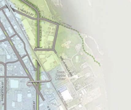
14 Confluence Parkway Corridor This component of the Plan targets increasing transportation capacity for autos, freight, and transit to enhance regional mobility. Confluence Parkway A new two-lane arterial corridor will be constructed by extending Miller Street south of the Wenatchee River to connect to uclid Avenue and US 2. The Miller Street intersection with the North Wenatchee Avenue would be modified to add capacity to provide for southbound traffic on Miller Street south of Maple Street. The new arterial will directly benefit regional traffic, freight, and Intercity transit service. A new bridge would be constructed over the Wenatchee River reducing the bottleneck on the existing bridge. Improvements include under-crossings of Miller Street with the mainline SF railroad tracks and with Walla Walla Avenue. The Loop Trail will be relocated and upgraded to enhance visibility and access near awley Street. North of the Wenatchee River the new roadway will connect to an improved uclid Avenue to provide regional access with US 2. Confluence Parkway Additional Components To support access and circulation to the waterfront, awley Street will need to be extended east of Miller Street to connect with a northern extension of Walla Walla Avenue adjacent to the existing park. North of the Wenatchee River a new intersection will be developed with the Parkway by extending Technology Center rive; the existing intersection of Penny Road and uclid Avenue also will be upgraded. These upgraded east-west roadways will improve connectivity and accessibility for trucks, general traffic, pedestrians, and bicyclists to the state park and industrial areas east of the railroad tracks. The new Confluence Parkway corridor shifts traffic away from North Wenatchee Avenue reducing congestion and improving safety. 12 North Wenatchee Transportation Master Plan


15 North Wenatchee Avenue Corridor Construction of the Confluence Parkway will greatly reduce forecast traffic volumes along North Wenatchee Avenue, allowing the highway to better serve existing and future businesses along the corridor. Therefore, improvements in the North Wenatchee Avenue corridor focus on improving safety, circulation/accessibility to businesses, and upgrading the look and feel of transportation facilities serving the business district. North Wenatchee Avenue This arterial highway is the spine of an auto-oriented business district from south of Miller Street to the Wenatchee River. The Plan identifies a range of enhancements to improve traffic flow including addition of turn lanes, installation of a new traffic signal, and improving traffic signal coordination. In addition, the Plan projects include incorporating landscaping, consolidating driveways, and restricting some turn movements to reduce the number of conflict points. ther improvements include improved signing, markings, and lighting in the corridor. Pedestrian and bicycle travel within and across the corridor will be enhanced with wider sidewalks, upgraded crosswalks, and improved signal detection of bicycles. Transit stops and shelters will also be constructed or upgraded as part of the roadway, intersection, and sidewalk improvements. SR 285/asy Street/Penny Road Northbound ff-ramp The existing northbound off-ramp from the Wenatchee River Bridge to lds Station directs most traffic to the intersection of Penny Road at asy Street. The Plan includes a project to modify the off-ramp to allow traffic to turn east and connect to Technology Center rive. This will increase the accessibility to the developing lds Station area, as well as a through connection to the Confluence Parkway corridor. Canal Trail A multi-use trail is proposed along the existing Pioneer Canal right-of-way on the west side of North Wenatchee Avenue between the Wenatchee River and Walnut Street. The trail would include an undercrossing of Maiden Lane to eliminate conflicts with traffic. In addition, the existing pedestrian facility on the west side of the Wenatchee River Bridge will be widened or a new facility will be constructed. These combined facilities provide a new corridor to improve safety and accessibility for pedestrians and bicyclists, as well as reducing conflicts with vehicular traffic. The trail also would provide access to transit stops near Maiden Lane. North Wenatchee Avenue in the Vicinity of Maiden Lane The segment of North Wenatchee Avenue near Maiden Lane and orse Lake Road was identified as one of the most critical safety and traffic flow issues in the study corridor. The Plan calls for constructing a new access road on the east side of North Wenatchee Avenue. This would allow modification of access points which are the source of many collisions. In addition, the intersection of North Wenatchee Avenue at Maiden Lane would be modified to increase capacity and reduce impacts of traffic backups. Pedestrian facilities and transit stops in the vicinity of Maiden Lane and orse Lake Road also would be upgraded. North Wenatchee Transportation Master Plan 13


16 awley Street Undercrossing The Plan recommends reconstructing awley Street to cross under the SF railroad tracks east of North Wenatchee Avenue. The undercrossing will reduce delays and improve safety for a full range of travel modes. The undercrossing also will facilitate potential changes to enhance transit service to the waterfront. Pedestrian and Bicycle vercrossing To improve the connectivity and safety for bicyclists and pedestrians, a new overcrossing will be constructed in the vicinity of Miller Street and North Wenatchee Avenue. The new facility will cross over North Wenatchee Avenue, Miller Street, and the railroad tracks connecting the Valley North Mall commercial district with the waterfront. The new overcrossing would also connect with the new transit center. North Wenatchee Transit Center and Transit Service To provide a focal point for improved transit service, a new transit center is proposed to be constructed in the vicinity of Miller Street and North Wenatchee Avenue. This location provides excellent access to the Confluence Parkway which would serve the Intercity regional transit routes. The transit center also would increase transit access to the Valley North Mall commercial district and waterfront via the new pedestrian and bicycle overcrossing. Local transit service for North Wenatchee also would be able to connect at the transit center to facilitate transfers and the overall connectivity of transit service in North Wenatchee. Bus pullouts would also be incorporated along North Wenatchee Avenue in the vicinity of Maple, McKittrick and awley Streets. North Wenatchee Avenue Corridor Additional Components An extensive list of additional multimodal projects and programs were identified to support the above major improvements to improve transportation within the North Wenatchee Avenue Corridor. The most significant of these additional components are the new collector and local access roadways. xisting streets will be reconstructed to collector standards to provide alternative east-west routes between Western Avenue and North Wenatchee Avenue. Completion of new north-south collector roadways to improve business access and circulation between neighborhoods also are included. The updated circulation roads also will include improved facilities for bicyclists and pedestrians. The Plan also includes a range of projects and programs for improving overall transportation service within the North Wenatchee Avenue corridor. These include traffic signal coordination, spot sidewalk repairs, upgrades to bus stops and shelters, and improved signing and markings. Improved pedestrian facilities along and crossing North Wenatchee Avenue will enhance safety and accessibility. For example, modified McKittrick Street as shown above 14 North Wenatchee Transportation Master Plan
17 What are the costs of the Plan? Preliminary estimates for the total of all roadway, intersection, transit center, and pedestrian and bicycle improvements are estimated to be between $190 and $230 million, in 2010 dollars. Growth in costs associated for the modified transit operations or street maintenance and operations are not included in this figure. Costs within each of the three sub-components of the Transportation Master Plan are summarized in the following table. Improvements in the US 2 corridor are estimated to be in the approximate range of $ $50.2 million, or 22% of the total. The majority of these costs are associated with the reconstruction of the US 2/SR 285/asy Street Interchange. Constructing the new Confluence Parkway and associated improvements are estimated to range between $ $88.6 million, or 38% of the total. Upgrading and improving the existing North Wenatchee Avenue corridor for better safety, traffic flow, and connectivity is estimated to cost between $ $92.3 million. This represents approximately 40% of the total Plan. Improvement Cost stimate Percent Range of Plan Costs 1 US 2 Corridor & Connections to North Wenatchee $ $50.2 million 22% US 2/SR 285/asy Street Interchange $ $40.0 million US 2/uclid Avenue Interchange $1.6 - $1.9 million US 2 Corridor Additional Components $6.8 - $8.3 million Confluence Parkway Corridor $ $88.6 million 38% Confluence Parkway $ $85.0 million Confluence Parkway Additional Components $2.9 - $3.6 million North Wenatchee Avenue Corridor $ $92.3 million 40% North Wenatchee Avenue $6.1 - $8.1 million SR 285 Northbound ff-ramp to asy Street $0.4 - $0.5 million Canal Trail $9.0 - $11.0 million awley Street Undercrossing $ $21.0 million Pedestrian and Bicycle vercrossing $ $12.0 million North Wenatchee Transit Center $ $15.0 million North Wenatchee Avenue Corridor Additional Components $ $24.7 million 1. Plan = Transportation Master Plan Grand Total $ $231.1million North Wenatchee Transportation Master Plan 15
18 ow might the Plan be funded? ue to the relatively high cost of the Plan, implementation will require a combination of local, regional, state, and/or federal funding, and certain elements may be implemented as part of private development. Funding for many of the lower cost capital improvement projects, as well as maintenance and operations, will likely come from local jurisdictions. The higher cost projects, such as the Confluence Parkway and US 2 interchange projects will require state or federal funding, or a major new regional funding source. The City of Wenatchee and Chelan County will be the primary local jurisdictions implementing many of the Plan improvements, particularly upgrading intersections, sidewalks, and local roadways, although local funding will always compete with other needs in other parts of the City and County. Many of the improvements will be eligible to compete for state Transportation Improvement Board and County Road Administration Board grants based on their ability to improve safety, traffic flow, and support economic development. ther grant programs exist to support implementation of pedestrian and bicycle improvement projects that are consistent with the Plan. It is recommended that the local jurisdictions work together and support each other in systematically pursuing grants for Plan improvements, as opposed to submitting applications that could adversely compete with each other. Local jurisdictions can also pursue loans through the Public Works Trust Fund or issue bonds (debt) to accelerate funding for high-priority components of the Plan. Certain improvements could be required by the City of Wenatchee as commercial properties develop or redevelop within the corridor. These could include construction of frontage and pedestrian improvements, or contributions toward new circulation/access roads. Future development could also be required to contribute funding for traffic safety, operations, or sidewalk improvements through SPA mitigation or to meet GMA concurrency standards. Link Transit may be able to assist in funding some of the improvements. Link Transit is funded primarily through local sales tax revenues, fare box revenues, and grants, and has a direct interest and benefit in improving the corridor in order to provide more reliable and effective transit service for their customers. Transit funding could be directed toward the new north-end Transit Center, improvements to bus stops/ shelters, and improving pedestrian and bicycle infrastructure near bus stops. Link also has identified the Confluence Parkway as the key element of the Plan that supports efficient operation of the intercity bus routes that do not need to stop at locations along North Wenatchee Avenue. Link Transit should review and continually evaluate grant funding programs that may be appropriate to accomplish the transit related elements of the Plan, and work with the City of Wenatchee, Chelan County, and W to help fund transit stop and service improvements that can be tied to other highway and roadway projects, such as additional bus pull-outs along North Wenatchee Avenue. WVTC and its member agencies will work together to pursue funding for regional and state highway improvements through the state legislature and through Congress. In particular, federal and/or state funding is appropriate and necessary for the US 2 interchange improvements and construction of the Confluence Parkway. These improvements are the core elements of the Plan and cannot be funded through existing and available local funding mechanisms. US 2 and the Confluence Parkway address key issues in the Metropolitan Transportation Plan and are consistent with federal and state transportation goals. 16 North Wenatchee Transportation Master Plan
19 Creation of a regional Transportation Benefit istrict could be considered to help fund some of the Plan Improvements, and to help provide matching funds for state and federal grants.verall, funding for the Plan will require a wide range of strategies. New, dedicated funding will be required from state or federal programs to complete the most significant projects while local jurisdictions can focus on funding the lower-cost improvement projects. WVTC will continue to work with its members in pursuing a systematic approach for implementing the Plan. ow will the Plan be Implemented? Short-Term Improvements The Transportation Master Plan has identified a list of projects that should be implemented within the next several years, as summarized in the following table. The City of Wenatchee would be lead agency for most of the short-term improvement projects. owever, the City must be supported by WVTC and other agencies to implement these improvements in recognition that they are part of a larger regional plan. epending on the availability of funding and time needed for environmental review, project design, and coordination with affected property and business owners some of these projects may take longer. ther projects not identified on this list also may be implemented at an earlier date depending on overall agency priorities and/or opportunities related to development or redevelopment of specific properties. Project Location (Limits) US 2 at asy Street Intersection Confluence Parkway (North Wenatchee Avenue to US 2) North Wenatchee Avenue Vicinity of Maiden Lane North Wenatchee Avenue at McKittrick Street North Wenatchee Avenue at Miller Street North Wenatchee Avenue/Miller Street Corridor (5th Street to Wenatchee River) North Wenatchee Avenue (Red Lion Inn to Miller Street) awley Street (North Wenatchee Avenue to Miller Street) McKittrick Street (North Wenatchee Avenue to Pine Street) Pedestrian and Bicycle vercrossing (Valley North Mall to waterfront) Walnut Street (Pine Street to Stella Avenue) North Wenatchee Avenue Corridor (Wenatchee River to Miller Street) Pine Street (Walnut Street to McKittrick Street) SR 285 Northbound ff-ramp to asy Street escription Upgrade signing and markings, as appropriate. Potentially eliminate right turn on red for southbound approach prior to constructing the overcrossing Prepare environmental review and preliminary design studies Construct access road and intersection modifications Install traffic signal and turn lanes Modify roadway and intersection to allow southbound traffic from Miller Street south of Maple Street Upgrade traffic signal interconnect system Upgrade and widen sidewalks Construct undercrossing of railroad and upgrade pedestrian and bicycle facilities Reconstruct roadway including pedestrian and bicycle facilities Construct pedestrian and bicycle overcrossing of North Wenatchee Avenue, Miller Street, and railroad tracks Reconstruct roadway including pedestrian and bicycle facilities Spot sidewalk and bicycle improvements; upgrade pedestrian and bicycle detection and markings; and audio pedestrian crossings Reconstruct roadway including pedestrian and bicycle facilities Provide direct off-ramp and roadway connection between asy Street and Technology Center rive North Wenatchee Transportation Master Plan 17
20 Confluence Parkway Phasing The Confluence Parkway will require several years of committed regional effort to implement. As an initial step, the Confluence Parkway corridor will need to be incorporated into regional and local agency plans. This will allow WVTC and its member agencies to proceed with environmental review and preliminary design studies. Final designs and right-of-way acquisition would then commence, followed by construction. Construction phasing will depend on the final design, funding availability, and right-ofway needs. Preliminary analyses indicate that initial improvements may focus on the segment of Miller Street between awley Street and North Wenatchee Avenue, including the Miller Street undercrossing of the railroad tracks and associated improvements. The Parkway improvements north of the Wenatchee River in the lds Station area would then be completed. The Parkway would then be opened to traffic following construction of a new bridge over the Wenatchee River and the connecting road segment from the bridge to awley Street. Where can I get more information on the North Wenatchee Transportation Master Plan? The Wenatchee Valley Transportation Council (WVTC) is the lead agency for the Transportation Master Plan. Jeff Wilkens, WVTC s xecutive irector, led the development of the Plan. is contact information is: Jeff Wilkens xecutive irector Wenatchee Valley Transportation Council 300 South Columbia Street Wenatchee, WA Phone: (509) mail: info@confluenceparkway.org Additional technical detail also can be found in the North Wenatchee Transportation Plan Study Report and Appendices. The Study Report is available online at Copies of the Plan are also available at the WVTC office, City of Wenatchee Public Works, and the Wenatchee and ast Wenatchee Libraries. 18 North Wenatchee Transportation Master Plan
21 Appendix: North Wenatchee Transportation Master Plan


22 North Wenatchee Transportation Master Plan Components FIGUR A-1 NT T SCAL US 2 Corridor & Connections to North Wenatchee Confluence Parkway Corridor North Wenatchee Avenue Corridor
 Project escription Modes Served Costs in millions US 2 Corridor & Connections to North Wenatchee Improvements $41.4 - $50.")


 Construct new parallel 2-lane arterial corridor by extending Miller Street to connect with to uclid Avenue,")

23 North Wenatchee Transportation Master Plan Cost stimates Adopted February 2011 FIGUR A-2 Project Ref No. Project Name (Limits) Project escription Modes Served Costs in millions US 2 Corridor & Connections to North Wenatchee Improvements $ $ US 2 / SR 285 / asy Street Interchange Reconstruct interchange of US 2 / SR 285 to straighten US 2 as the through route while maintaining capacity to/ from Wenatchee and accessibility to serve existing development and economic growth in the Sunnyslope and lds Station areas. Improve traffic safety and operations by eliminating the existing traffic signal at US2 / asy Street and constructing a new overcrossing of US 2. $33.0 to $ Modify US 2 / uclid Avenue Interchange Modify existing interchange to improve traffic flow and connections with new Confluence Parkway. $1.6 to $1.9 2 Improve traffic flow and safety to support economic development and accessibility to Loop Trail through improvements along asy Street, Penny Road, and constructing a new multi-use trail south of US 2 between asy Street and uclid Avenue. US 2 Corridor- Additional Components evelop and upgrade local circulation and access roads to support development of the area and improve safety and connectivity for pedestrians and bicyclists. $6.8 to $8.3 1 Construct improved transit stops and install shelters at priority bus stops to enhance accessibility of transit in the lds Station and Sunnyslope areas. Confluence Parkway Corridor Improvements $ $ Confluence Parkway (Miller Street/ North Wenatchee Avenue to uclid Avenue/US 2) Construct new parallel 2-lane arterial corridor by extending Miller Street to connect with to uclid Avenue, including a new bridge over the Wenatchee River. The new corridor will provide an alternative corridor to enhance regional mobility and add capacity for autos, trucks, and regional transit service. Improvements will include an undercrossing of the railroad tracks and Walla Walla Avenue to reduce delays and safety conflicts for vehicular and non-motorized travel. The Loop Trail will be relocated and improved. The Confluence Parkway will connect with the proposed Transit Center near Miller Street and North Wenatchee Avenue to further improve multimodal connectivity to regional attractions in Wenatchee. $70.0 to $ Confluence Parkway Corridor- Additional Components South of the Wenatchee River, awley Street will be extended to connect to Walla Walla Avenue to maintain and improve accessibility and connectivity between North Wenatchee Avenue and the waterfront. North of the Wenatchee River, Penny Road/uclid Avenue and Technology Center rive will be reconstructed to improve connections across the railroad tracks for trucks, autos, and enhance access to the Loop Trail and state park. $2.9 to $3.6 9 North Wenatchee Avenue Corridor Improvements $ $ North Wenatchee Avenue (South of Miller Street to Wenatchee River) Upgrade existing North Wenatchee Avenue to improve safety, operations, and transportation accessibility to support business access and economic development within the corridor. Improvements include intersection capacity, new traffic signals, traffic signal interconnects, wider sidewalks, streetscape and landscaping, access consolidation, street lighting, median safety improvements, and signing and marking upgrades. In addition, construct bus pullouts and upgrade transit stops and shelters along North Wenatchee Avenue as part of intersection, roadway, and standalone improvement projects. $6.1 to $ awley Street (North Wenatchee Avenue to Miller Street) Construct undercrossing of railroad tracks and upgrade non-motorized facilities to improve accessibility between North Wenatchee Avenue and waterfront and connections to Confluence Parkway. $17.8 to $ Pedestrian and Bicycle Bridge and Connections to Waterfront (North Wenatchee Avenue to Parks) Construct pedestrian and bicycle bridge over North Wenatchee Avenue, Miller Street, and railroad tracks to improve safety and accessibility between commercial development and waterfront, as well as connections to new transit center. $10.0 to $ North Wenatchee Transit Center and Transit Service SR 285 asy Street / Penny Road Northbound ff-ramp Construct new transit center in the vicinity of North Wenatchee Avenue / Miller Street / Confluence Parkway to provide a focal point for transit service and connectivity to North Wenatchee Avenue commercial area and waterfront. Relocate intercity, regional transit from North Wenatchee Avenue to Confluence Parkway to reduce delays along the corridor. Revise local transit service to use future roadway undercrossings at awley Street and/or Miller Street and upgraded circulation roads to enhance transit service coverage in corridor and areas west of North Wenatchee Avenue. Modify SR 285 northbound off-ramp to provide new direct connection to Technology Center rive to support growth and connectivity with lds Station area. $10.0 to $15.0 $0.40 to $0.500 Modes Served Autos Canal Trail (Wenatchee River to Walnut Street) Construct multi-use trail on west side on North Wenatchee Avenue using existing canal alignment and right-of-way including an undercrossing of Maiden Lane. In addition, widen or construct new pedestrian facility on west side of Wenatchee River Bridge. These improvements will provide a key non-motorized corridor to improve accessibility and safety for pedestrians and bicyclists within the North Wenatchee Avenue corridor and connectivity to the Loop Trail. $9.0 to $11.0 Pedestrians Transit North Wenatchee Avenue Corridor- Additional Components Construct system of frontage and circulation roadways and upgrade existing roadways to improve safety, operations, and accessibility to existing and future businesses. Improvements would include facilities for bicyclists, pedestrians, and transit service. Work with property owners and businesses to improve internal vehicular and non-motorized circulation within and between parking lots to reduce safety and operations impacts on adjacent arterials and collector roadways, and to support economic growth through redevelopment opportunities. $20.2 to $24.7 Bicycles Freight Grand Total $ $231.1
 Project escription FIGUR Adopted February 2011 A-3 Costs in millions Modes")


 Reconstruct and widen asy Street with median, new traffic")


")


24 North Wenatchee Transportation Master Plan Cost stimates Project Ref No. Project Name (Limits) Project escription FIGUR Adopted February 2011 A-3 Costs in millions Modes Served US 2 Corridor & Connections to North Wenatchee Improvements Reconstruct existing interchange to provide direct eastbound traffic flow on US 2 S1 1 Remove existing traffic signal at US 2/ asy Street and construct new overcrossing of US 2 at asy Street with pedestrian and bicycle facilities US 2 / SR 285 / asy Street Interchange $33.0 to $40.0 Construct new local circulation roads and ramps to connect lds Station and Sunnyslope to US 2 S2 2 Modify US 2 / uclid Avenue Interchange Modify interchange to improve connections with new Confluence Parkway $1.6 to $1.9 S3 asy Street (US 2 to Penny Road) Reconstruct and widen asy Street with median, new traffic signal, and pedestrian and bicycle facilities $2.7 to $3.3 S4 lds Station Circulation Roads Construct new and upgrade existing local roads to improve access and circulation roads within lds Station commercial and industrial areas $1.5 to $1.8 S5 lds Station Subarea Pedestrian and Bicycle Facilities Complete sidewalks and bicycle facilities on Penny Road, Chester Kimm Road, and lds Station Road $1.2 to $1.4 S6 asy Street / US 2 Pedestrian Facilities and Bicycle Route (Peters Street to uclid Avenue) Construct new pedestrian and bicycle pathway / trail along asy Street north of US 2 to uclid Avenue south of US 2 $1.3 to $1.6 S7 Transit Stops and Shelters Construct improved transit stops and install shelters at priority bus stops in lds Station and Sunnyslope areas $0.05 to $0.1 S8 US 2 / asy Street Intersection Upgrade traffic signing and markings $0.04 to $0.06 liminate right-turn on red for southbound approach Grand Total N AR Modes Served M S R G AR N VIW PL ALVIA PL ALVIA R LP TIL AV AR T IS N IS LL R NW5 LS ATIN R TC LS ATIN R X# IL US 2 & Connections to North Wenatchee Improvements TR A A N R CATAM ILL R R CATAM I R IS T MA L AT C IL N A RT TCNLGY CNTR R I LL UR U-Turn Route S5 AM Interchange Modification New Arterial or Collector Roadway New Access/ Circulation Road Upgrade xisting Roadway Roadway Median Treatment SP IL R L ASY ASY SC S7 Park & Ride UCLI AV GUNN R PNNY R R R PNNY PNNY New Bridge A S3 S1 SF Bicycles LGN S4 Transit 2 [ Freight SF INKS Pedestrians S6 M S8 UCLI AV [ S2 WAR PTRS SCL PTRS 2 Autos U SCL W PTRS $ $50.2 R G 97A [ FIGUR Pedestrian and Bicycle vercrossing or Trail Pedestrian and Bicycle Facilities Intersection Improvement With xisting Signal Intersection Improvement With New Signal Ramps/Roadway to be Removed Transit Center Project Reference Number


25 North Wenatchee Transportation Master Plan Cost stimates G U S G AR N S5 CP1 WAR LP TIL SP UR UCLI AV AR T RT N A IS N LGN New Bridge L 285 À ¾ NA1 Move intercity transit service from North Wenatchee Avenue to Confluence Parkway LS ATIN R L L R R AI I LL A TR R P IL $2.9 to $3.6 NW5 LS ATIN R AM N R CATAM ILL R Construct 2 lane collector road with pedestrian and bicycle facilities IS R IS T MA L AT C SF R A IL SF L PNNY R TCNLGY CNTR R Intercity Transit Service Park & Ride R R PNNY PNNY Widen and upgrade existing uclid Avenue north of Penny Road Interchange Modification New Arterial or Collector Roadway New Access/ Circulation Road Upgrade xisting Roadway Roadway Median Treatment CP1 $ $88.6 We nat che R LAK er iver U-Turn Route AWN TR N WRN AV S MAIN LN CP3 NW TC AW L Y CP1 A N MILLR PRSING PRINCTN PRINCTN Town Toyota Center NW3 NNMILLR MILLR Pedestrians Transit Confluence Parkway Corridor Improvements 9T WW AV IR NP SPRINGWATR AV A ILR SF NW23 AV V A C AT NC T AT V N NS N NA NW SII LA SS NW MIIS NM N NC PRSING NW4 TC SR 285 North Wenatchee Transportation Master Plan IL V VA A ALLA LLA AAW ALLW LLA W WA CNTL CNTL AV AV CP2 TACMA NNTACMA Modes Served Freight PT N MILLR PIN R A AIL R ILSRF N SF B L MAPL Bicycles Project Reference Number PRSING V A X# MCKITTRICK Autos Transit Center r Rive C AT N WALNUT bia lum Co Pedestrian and Bicycle vercrossing or Trail Pedestrian and Bicycle Facilities Intersection Improvement With xisting Signal Intersection Improvement With New Signal Ramps/Roadway to be Removed Walmart ome epot N WRN AV 1. Cost estimates not developed for transit service changes. R Grand Total N WRN AV CP3 ASY SC Upgrade and construct new signalized intersections at Penny Road/uclid Avenue and Technology Center rive / Confluence Parkway with pedestrian and bicycle connections to Loop Trail; close existing railroad crossing at lds Station Road awley Street / Park Connection (Miller Street to Walla Walla Avenue) GUNN R $70.0 to $85.0 Reconstruct Miller Street / North Wenatchee Avenue intersection to allow for southbound traffic and increased capacity UCLI AV INKS Realign existing railroad spur tracks in lds Station area to construct Parkway CP2 ALVIA CP1 3 Construct Miller Street undercrossing of railroad tracks and Walla Walla Avenue, including pedestrian and bicycle facilities and new traffic signal at awley Street 2 [ AV 2 [ Construct new bridge over Wenatchee River and undercrossing of railroad spur tracks S2 M Relocate and improve Apple Loop Trail between awley Street and Wenatchee River PTRS W PTRS ALVIA PL Construct new 2-lane arterial parallel to North Wenatchee Avenue by extending Miller Street to connect to uclid Avenue Confluence Parkway (Miller Street/ North Wenatchee Avenue to uclid Avenue/US 2) R M PTRS $ $88.6 R N AR ASY Confluence Parkway Corridor Improvements A-4 97A [ Costs in millions VIW PL Modes Served CATAM IL Project escription SCL Project Name (Limits) SCL Project Ref No. FIGUR Adopted February 2011 TT SS 9T 9T


 L NW7 PNNY R R R PNNY PNNY [ NW29 UCLI IL R A SP UR NW6 Systematically Upgrade Transit Stops and Shelters SF $0.4 to $0.")


 XX CATAM IL NW1 97A [ Projects listed in this Figure.")


 ome epot A Local Transit Service $0.8 to $1.")
26 North Wenatchee Transportation Master Plan Cost stimates Canal Trail (orse Lake Road to Walnut Street) Construct new multi-use trail along existing dike right-of-way with undercrossing of Maiden Lane $2.4 to $3.0 S R U WAR Move Intercity Transit to Confluence Parkway AV NW30 AR T RT IS N N A IS LGN New Bridge 285 À ¾ L Upgrade signal interconnect with adjacent signals at orse Lake Road and ome epot/walmart / Maiden Lane signals LS ATIN R L R AI A TR R LS ATIN R P IL Upgrade transit stops I LL AM NW5 N R CATAM ILL R SF L R $1.4 to $1.8 Upgrade crosswalks and pedestrian facilities at intersections R IS T MA L Modify intersections at orse Lake Road and Maiden Lane Widen intersection to provide two north-to-west left turn lanes and provide for U-turns Maiden Lane / North Wenatchee Avenue Intersection G G AR N TCNLGY CNTR R Modify access driveways and install medians NW8 2 Modify Local Transit Service (as appropriate with new roadways) AV Construct new northbound frontage road on east side of North Wenatchee Avenue to improve safety and operations AT C Maiden Lane / orse Lake Road Frontage Road (500 feet south of Maiden Lane to orse Lake Road) L NW7 PNNY R R R PNNY PNNY [ NW29 UCLI IL R A SP UR NW6 Systematically Upgrade Transit Stops and Shelters SF $0.4 to $0.5 GUNN R SC NW5 Modify SR 285 northbound off-ramp to provide new direct connection to Technology Center rive and Chester Kimm Road ASY INKS SR 285 asy Street / Penny Road Northbound ff-ramp UCLI AV $17.0 to $20.0 North Wenatchee Avenue Traffic Signal System Improvements LP TIL [ 2 NW25 NW28 PTRS W PTRS NW20 North Wenatchee Avenue Interim Pedestrian and Sidewalk Impromements PTRS Upgrade street lighting Construct undercrossing of railroad tracks and upgrade pedestrian and bicycle facilities M $1.5 to $2.0 A-5A TR PRJCTS R N AR ALVIA awley Street (North Wenatchee Avenue to Miller Street) Upgrade arterial corridor with wider sidewalks, streetscape, access consolidation, and median safety improvements Projects listed in Figure A-5B. ALVIA PL NW2 North Wenatchee Avenue (South of Miller Street to Wenatchee River) XX CATAM IL NW1 97A [ Projects listed in this Figure. North Wenatchee Avenue Corridor Improvements XX M Costs in millions ASY Modes Served VIW PL Project escription SCL Project Name (Limits) SCL Project Ref No. FIGUR Adopted February 2011 Interchange Modification New Arterial or Collector Roadway New Access/ Circulation Road Upgrade xisting Roadway Roadway Median Treatment NW26 $0.2 to $0.3 Upgrade crosswalks and pedestrian signals R AWN TR N WRN AV NW17 NW15 N MILLR Town Toyota Center NW3 NW19 NW27 SPRINGWATR AV WW AV IR NP Freight NW4 TC NW16 NW23 Transit Bicycles N MILLR PRSING NW22 PRSING NW1 A Pedestrians IL ILR CNTL CNTL AV AV Autos PT AV V A C AT NC TT S AT V N NS N NA NW SII LA SS NW MIIS NM N NC N WRN AV $ $42.2 L SF (see Figure A-5B for Grand Total) NW21 MAPL Modes Served Sub Total NW11 PRINCTN PRINCTN Construct passenger shelters at highest priority locations NW9 MCKITTRICK NW14 Y V VA LAA N WRN AV $0.05 to $0.10 Systematically upgrade transit stops AW L NW28 Project Reference Number AL LLA AAW ALLW LLA W WA Conduct evaluation of existing and additional transit stops along North Wenatchee Avenue to identify changes in conjunction with roadway, intersection, sidewalk and signal system upgrades NNMILLR MILLR NW12 NA1 Transit Center X# NW13 TACMA NNTACMA Review and adjust local transit service routing to reflect future railroad grade separations and circulation roads to serve new development, as appropriate NW18 PIN NA1 Increase mid-day and peak period intercity transit service WALNUT PRSING NW10 NW2 r Rive $6.6 to $8.0 Move intercity transit service from North Wenatchee Avenue to Confluence Parkway 1. Cost estimates not developed for transit service changes. TC NW6 NW1 bia lum Co Widen existing or construct new pedestrian facility on west side of Wenatchee River Bridge and upgrade sidewalk connection to orse Lake Road NW30 North Wenatchee Avenue Transit Stops and Shelters (5th Street to Wenatchee River Bridge) ome epot A Local Transit Service $0.8 to $1.0 Improve existing at-grade crossing of railroad tracks for bicycles R A AIL R ILSRF N SF B NW29 NW7 V A Intercity Transit Service MAIN LN C AT NW28 Pedestrian and Bicycle vercrossing or Trail Pedestrian and Bicycle Facilities Intersection Improvement With xisting Signal Intersection Improvement With New Signal Ramps/Roadway to be Removed NW8 Walmart NW26 Wenatchee Bridge Pedestrian Facilities (Chatham ill Road to orse Lake Road) Complete and upgrade sidewalks U-Turn Route N NW18 awley Street (North Wenatchee Avenue to Loop Trail) $1.3 to $1.6 er iver NW Reconstruct and upgrade roadway to collector standards including pedestrian and bicycle facilities NW1 NW13 Pine Street (Walnut Street to McKittrick Street) $3.2 to $3.9 R Reconstruct and upgrade roadway to collector standards including pedestrian and bicycle facilities We nat che LAK NW10 Walnut Street (Pine Street to Western Avenue) NW6 S Provide undercrossing of Maiden Lane for ike Trail (NW-6) TT SS 9T 9T North Wenatchee Avenue Corridor Improvements 9T
Basalt Creek Transportation Refinement Plan Recommendations
 Basalt Creek Transportation Refinement Plan Recommendations Introduction The Basalt Creek transportation planning effort analyzed future transportation conditions and evaluated alternative strategies for
Main-McVay Transit Study: Phase 2 Options Definition and High Level Constraints Evaluation
 Main-McVay Transit Study: Phase 2 Options Definition and High Level Constraints Evaluation APRIL 2016 A collaborative study between: For Additional Information or to Comment If you would like additional
5. RUNNINGWAY GUIDELINES
 5. RUNNINGWAY GUIDELINES These guidelines should be considered collectively when making runningway decisions. A runningway is the linear component of the transit system that forms the right-of-way reserved
Solana Beach Comprehensive Active Transportation Strategy (CATS)
") Solana Beach Comprehensive Active Transportation Strategy (CATS) 3.0 Goals & Policies The Solana Beach CATS goals and objectives outlined below were largely drawn from the Solana Beach Circulation Element
Solana Beach Comprehensive Active Transportation Strategy (CATS) 3.0 Goals & Policies The Solana Beach CATS goals and objectives outlined below were largely drawn from the Solana Beach Circulation Element
Executive Summary Route 30 Corridor Master Plan
 Route Corridor Master Plan Project Overview The Route Corridor Master Plan is a coordinated multimodal transportation and land use plan for the entire stretch of Route through East Whiteland Township,
San Jose Transportation Policy
 San Jose Transportation Policy Protected Intersections in LOS Policies to Support Smart Growth Presented by: Manuel Pineda City of San Jose Department of Transportation Bay Area Map San Francisco Oakland
Chapter 5 Future Transportation
 Chapter 5 Future Transportation The Future Land Use Plan identifies the desired land use designations. The land uses desired for Crozet depend, in large part, on the success of the transportation system,
o n - m o t o r i z e d transportation is an overlooked element that can greatly enhance the overall quality of life for the community s residents.
 N o n - m o t o r i z e d transportation is an overlooked element that can greatly enhance the overall quality of life for the community s residents. 84 Transportation CHAPTER 11 INTRODUCTION Transportation
City of Seattle Edward B. Murray, Mayor
 City of Seattle Edward B. Murray, Mayor Department of Transportation Scott Kubly, Director Eastlake Community Council 117 E Louisa St. #1 Seattle, WA 98102-3278 January 28, 2016 RE: Roosevelt to Downtown
Bus Rapid Transit Plans
 Twin Cities Region Bus Rapid Transit Plans ULI Minnesota Workshop Connecting Bus Rapid Transit to the Community December 15, 2009 John Levin Director of Service Development Metro Transit Metropolitan Area
ROUTES 55 / 42 / 676 BUS RAPID TRANSIT LOCALLY PREFERRED ALTERNATIVE
 ROUTES 55 / 42 / 676 BUS RAPID TRANSIT LOCALLY PREFERRED ALTERNATIVE April, 2012 1 INTRODUCTION The need for transit service improvements in the Routes 42/55/676 corridor was identified during the Southern
Highway 217 Corridor Study. Phase I Overview Report
 Highway 217 Corridor Study Phase I Overview Report November 3, 24 BACKGROUND AND OVERVIEW Study purpose The Highway 217 Corridor Study is developing multi-modal transportation solutions for traffic problems
Clackamas County Comprehensive Plan
 ROADWAYS The County s road system permits the movement of goods and people between communities and regions, using any of a variety of modes of travel. Roads provide access to virtually all property. They
Regional Transportation Needs Within Southeastern Wisconsin
 Regional Transportation Needs Within Southeastern Wisconsin #118274 May 24, 2006 1 Introduction The Southeastern Wisconsin Regional Planning Commission (SEWRPC) is the official areawide planning agency
Circulation in Elk Grove includes: Motor vehicles, including cars and trucks
 Circulation, as it is used in this General Plan, refers to the many ways people and goods move from place to place in Elk Grove and the region. Circulation in Elk Grove includes: Motor vehicles, including
City of Gainesville Transportation/Roadway Needs PROJECT SUMMARY
 A1 Roadway Resurfacing $23,846,000 TYPE: Preservation of existing system Roadway resurfacing A2 Signal Replacement $6,000,000 TYPE: Preservation of existing system Replace traffic signals. B1 W 6th St
PEDESTRIAN ACTION PLAN
 ATTACHMENT 2 CITY OF SANTA MONICA PEDESTRIAN ACTION PLAN CITY OF SANTA MONICA PEDESTRIAN ACTION PLAN This page intentionally left blank EXECUTIVE SUMMARY CHAPTER 1 EXECUTIVE SUMMARY Setting the Stage
Lee s Summit Road Improvement Study Public Open House June 7, 2007 Summary of Comment Card Responses
 Lee s Summit Road Improvement Study Public Open House June 7, 2007 Summary of Comment Card Responses Introduction At the Lee s Summit Road Improvement Study Public Open House held Thursday, June 7, 2007
4. ENVIRONMENTAL IMPACT ANALYSIS 9. TRANSPORTATION AND TRAFFIC
 4. ENVIRONMENTAL IMPACT ANALYSIS 9. TRANSPORTATION AND TRAFFIC 4.9.1 INTRODUCTION The following section addresses the Proposed Project s impact on transportation and traffic based on the Traffic Study
C C C
 C-012-001 Thank you for your support for the creation of new public space and nonmotorized access between downtown and the waterfront through the Overlook Walk, the East-West Connections, and the Promenade.
Bicycle Master Plan Goals, Strategies, and Policies
 Bicycle Master Plan Goals, Strategies, and Policies Mobilizing 5 This chapter outlines the overarching goals, action statements, and action items Long Beach will take in order to achieve its vision of
Environmental Assessment Findings & Recommendations. Public Hearing November 13, 2014
 Environmental Assessment Findings & Recommendations Public Hearing November 13, 2014 Welcome! Welcome and Introductions Project and Environmental Assessment Overview Public Comments Adjourn Purpose of
M-58 HIGHWAY ACCESS MANAGEMENT STUDY Mullen Road to Bel-Ray Boulevard. Prepared for CITY OF BELTON. May 2016
 M-58 HIGHWAY ACCESS MANAGEMENT STUDY Prepared for CITY OF BELTON By May 2016 Introduction Missouri State Highway 58 (M-58 Highway) is a major commercial corridor in the City of Belton. As development has
STUDY ADVISORY COMMITTEE. October 8, 2015
 STUDY ADVISORY COMMITTEE October 8, 2015 Study Purpose evaluate the long-term transportation strategies and investments needed to sustain the county s economic health and quality of life in the coming
Goal 3: Foster an environment of partnerships and collaboration to connect our communities and regions to one another.
 Non-Motorized Transportation Plan (NMTP) Draft Vision, Goal and,, Tri-County Regional Planning Commission (TCRPC) Purpose The purpose of the Tri-County Regional Planning Commission (TCRPC) Non-Motorized
Los Altos Hills Town Council - June 18, 2015 Palo Alto City Council June 22, AGENDA ITEM #2.B Presentation
 Los Altos Hills Town Council - June 18, 2015 Palo Alto City Council June 22, 2015 AGENDA ITEM #2.B Presentation Previous Presentations Los Altos Hills Town Council in May 2014 and February 2015 Palo Alto
CITY OF COCOA BEACH 2025 COMPREHENSIVE PLAN. Section VIII Mobility Element Goals, Objectives, and Policies
 CITY OF COCOA BEACH 2025 COMPREHENSIVE PLAN Section VIII Mobility Element Goals, Objectives, and Policies Adopted August 6, 2015 by Ordinance No. 1591 VIII MOBILITY ELEMENT Table of Contents Page Number
WEST AND SOUTH WEST RING ROAD DOWNSTREAM TRAFFIC IMPACTS
 Page 1 of 9 EXECUTIVE SUMMARY Alberta Transportation ( AT ) is preparing to construct the final sections of the Calgary Ring Road. This includes the South West Ring Road ( SWRR ) (from Lott Creek Blvd
5 CIRCULATION AND STREET DESIGN
 5 CIRCULATION AND STREET DESIGN This chapter describes circulation and streetscape improvements proposed for the Northwest Chico Specific Plan Area. It includes detailed design specifications for existing
City of Wayzata Comprehensive Plan 2030 Transportation Chapter: Appendix A
 A1. Functional Classification Table A-1 illustrates the Metropolitan Council s detailed criteria established for the functional classification of roadways within the Twin Cities Metropolitan Area. Table
3.0 PROJECT DESCRIPTION
 The following section of the Draft EIR contains a description of the proposed Elk Grove Boulevard/SR 99 Interchange Modification project, consistent with the requirements of CEQA Guidelines Section 15124.
NOTICE OF AVAILABILITY/NOTICE OF COMMENT PERIOD OF A DRAFT EIR/EIS/EIS FOR PUBLIC REVIEW AND HEARINGS
 Tahoe Transportation District 128 Market Street, Suite 3F Stateline, NV 89449 Phone: (775) 589-5500 www.tahoetransportation.org Federal Highway Administration 650 Capitol Mall, Suite 4-100 Sacramento,
WELCOME TO OPEN HOUSE # 1 June 14, 2017
 Langstaff Road Weston Road to Highway 7 Class Environmental Assessment Study WELCOME TO OPEN HOUSE # 1 June 14, 2017 Please sign in and join our mailing list Purpose of Open House #1 & Study Area York
Bicycle and Pedestrian Advisory Committee (BPAC) November 21, 2013
 November 21, 2013") Bicycle and Pedestrian Advisory Committee (BPAC) November 21, 2013 OVERALL LAND USE CONCEPT Overall Broadway Valdez District: 95.5 acres (35.1 acres right-of ways + 60.4 acres developable land) Plan Subareas:
Bicycle and Pedestrian Advisory Committee (BPAC) November 21, 2013 OVERALL LAND USE CONCEPT Overall Broadway Valdez District: 95.5 acres (35.1 acres right-of ways + 60.4 acres developable land) Plan Subareas:
Summary: Mercer County Princeton Avenue & Spruce Street Study January 2009
 Summary: Several recent studies have assessed potential development and redevelopment opportunities in the Mercer Crossing area of Trenton, Ewing, and Lawrence. This Princeton Avenue and Spruce Street
Route 7 Corridor Study
 Route 7 Corridor Study Executive Summary Study Area The following report analyzes a segment of the Virginia State Route 7 corridor. The corridor study area, spanning over 5 miles in length, is a multi
Access Management Regulations and Standards
 Access Management Regulations and Standards January 2014 Efficient highway operation Reasonable property access Concept of Access Management The way to manage access to land development while preserving
Southwest Bus Rapid Transit (SW BRT) Functional Planning Study - Executive Summary January 19 LPT ATTACHMENT 2.
 Functional Planning Study - Executive Summary January 19 LPT ATTACHMENT 2.") Southwest Bus Rapid Transit (SW BRT) Functional Planning Study - Executive Summary 2011 January 19 1 of 19 Introduction This executive summary presents the results of the Southwest Bus Rapid Transit (SW
Southwest Bus Rapid Transit (SW BRT) Functional Planning Study - Executive Summary 2011 January 19 1 of 19 Introduction This executive summary presents the results of the Southwest Bus Rapid Transit (SW
ACTIVE TRANSPORTATION
 ACTIVE TRANSPORTATION Mobility 2040 Supported Goals Improve the availability of transportation options for people and goods. Support travel efficiency measures and system enhancements targeted at congestion
SANTA MONICA BOULEVARD CORRIDOR
 CIRCULATION ELEMENT WHITE PAPER NO. 3 SANTA MONICA BOULEVARD CORRIDOR INTRODUCTION From the 1930s to the beginning of Los Angeles freeway era, Santa Monica Boulevard, (previously Route 66, the Beverly
City of Wilsonville 5 th Street to Kinsman Road Extension Project
 City of Wilsonville 5 th Street to Kinsman Road Walking Tour & Neighborhood Workshop Summary Report Public Outreach Overview On July 18 th, 2017, the City of Wilsonville hosted a neighborhood walking tour
STONY PLAIN ROAD STREETSCAPE
 Jasper Place Revitalization Strategy: Vision The people involved in the Jasper Place Revitalization Strategy envision: Goal 1: Feeling safe in our community Create a community where feeling safe is common--where
Welcome to the Quebec Alternatives Analysis Public Meeting
 Welcome to the Public Meeting Please sign in. Public Comment Please fill out a comment card and tell us what you think. Check back or comment any time at: www.quebecalternatives.com Project Area Technical
Route 29 Solutions Projects
 Route 29 Solutions Route 29 Solutions Projects www.route29solutions.org October 10, 2014 Route 29 Widening to Six Lanes Albemarle County This project will widen a 1.8-mile segment of Route 29 from four
TRAFFIC IMPACT ANALYSIS
 TRAFFIC IMPACT ANALYSIS FOR THE CHAMPAIGN UNIT#4 SCHOOL DISTRICT PROPOSED HIGH SCHOOL (SPALDING PARK SITE) IN THE CITY OF CHAMPAIGN Final Report Champaign Urbana Urbanized Area Transportation Study 6/24/2014
Chapter 7. Transportation. Transportation Road Network Plan Transit Cyclists Pedestrians Multi-Use and Equestrian Trails
 Chapter 7 Transportation Transportation Road Network Plan Transit Cyclists Pedestrians Multi-Use and Equestrian Trails 7.1 TRANSPORTATION BACKGROUND The District of Maple Ridge faces a number of unique
City of Moorhead Committee of the Whole Meeting
 City of Moorhead Committee of the Whole Meeting Corridor Study Limits Center Avenue (Red River to 8th Street) TH 10 (Red River to TH 336) TH 75 (20th Ave S to Main Avenue) 2 Study Need: Project Overview
Chapter 6 Transportation Plan
 Chapter 6 Transportation Plan Transportation Plan Introduction Chapter 6 Transportation Plan Transportation Plan Introduction This chapter describes the components of Arvada s transportation system, comprised
Living Streets Policy
 Living Streets Policy Introduction Living streets balance the needs of motorists, bicyclists, pedestrians and transit riders in ways that promote safety and convenience, enhance community identity, create
Omaha s Complete Streets Policy
 Omaha s Complete Streets Policy (Adopted August 2015) VISION To create great places and enhance our quality of life, the City of Omaha will provide safe, accessible streets for all users. Complete Streets
Route 79/Davol Street Corridor Study
 Route 79/Davol Street Corridor Study Fall River, MA Public Information Meeting #2 November 21, 2013 Fall River Heritage State Park Fall River, MA Agenda Welcome and Introductions Overview of Study Process
Princeton Avenue and Spruce Street Transportation and Site Access Enhancements Project
 Princeton Avenue and Spruce Street Transportation and Site Access Enhancements Project Mercer County Planning Division AECOM Transportation (formerly DMJM Harris) January 29, 2009 Agenda Project Status
CONNECTING PEOPLE TO PLACES
 CONNECTING PEOPLE TO PLACES 82 EAST BENCH MASTER PLAN 07 Introduction The East Bench transportation system is a collection of slow moving, treelined residential streets and major arteries that are the
Welcome. Thank you for your interest in the Lewis & Clark Viaduct Concept Study
 Welcome Thank you for your interest in the Lewis & Clark Viaduct Concept Study Please use the arrows in the upper left hand corner to navigate through the presentation. Use the envelope icon to ask a question
Transportation Master Plan Advisory Task Force
 Transportation Master Plan Advisory Task Force Network Alternatives & Phasing Strategy February 2016 BACKGROUND Table of Contents BACKGROUND Purpose & Introduction 2 Linking the TMP to Key Council Approved
Corpus Christi Metropolitan Transportation Plan Fiscal Year Introduction:
 Introduction: The Safe, Accountable, Flexible, Efficient Transportation Equity Act: A Legacy for Users (SAFETEA-LU) has continued the efforts started through the Intermodal Surface Transportation Efficiency
Develop a Multi-Modal Transportation Strategy (Theme 6)
") DEVELOP A MULTI-MODAL TRANSPORTATION STRATEGY (THEME 6) WHY IS THIS THEME ADDRESSED? Develop a Multi-Modal Transportation Strategy (Theme 6) Statement of Ideal Reduce resident and visitor reliance on single
DEVELOP A MULTI-MODAL TRANSPORTATION STRATEGY (THEME 6) WHY IS THIS THEME ADDRESSED? Develop a Multi-Modal Transportation Strategy (Theme 6) Statement of Ideal Reduce resident and visitor reliance on single
HARRISON STREET/OAKLAND AVENUE COMMUNITY TRANSPORTATION PLAN
 HARRISON STREET/OAKLAND AVENUE Community Workshop #4: Draft Plan Review December 3, 2009 D E S I G N, C O M M U N I T Y & E N V I R O N M E N T INTRODUCTIONS Key Project Staff: Alisa Shen, Project Manager,
Recommended Roadway Plan Section 2 - Land Development and Roadway Access
 Recommended Roadway Plan Section 2 - Land Development and Roadway Access SECTION 2 Land Development and Roadway Access 2.1 Land Use and Access Management The Federal Highway Administration (FHWA) defines
APPENDIX G: INTERSECTION NEEDS AT OKEECHOBEE BOULEVARD
 APPENDIX G: INTERSECTION NEEDS AT OKEECHOBEE BOULEVARD INTERSECTION NEEDS AT SR 7 and OKEECHOBEE BOULEVARD SR 7 Extension Project Development and Environment (PD&E) Study From Okeechobee Boulevard (SR
In station areas, new pedestrian links can increase network connectivity and provide direct access to stations.
 The Last Mile Planning for Pedestrians Planning around stations will put pedestrians first. Making walking to stations safe and easy is important; walking will be a part of every rapid transit Accessible
Highway 49, Highway 351 and Highway 91 Improvements Feasibility Study Craighead County
 Highway 49, Highway 351 and Highway 91 Improvements Feasibility Study Craighead County Executive Summary March 2015 Highway 49, Highway 351 and Highway 91 Improvements Feasibility Study Craighead County
Bikeway action plan. Bicycle Friendly Community Workshop March 5, 2007 Rochester, MN
 Bikeway action plan Summary The was held on March 5, 2007 at the Rochester Mayo Civic Center. The workshop was hosted by Rochester-Olmsted County Planning Department in collaboration with the League of
5.0 Roadway System Plan
 Southwest Boise Transportation Study Page 16 5.0 Roadway System Plan The Roadway System Plan outlines roadway improvements in the Initial Study Area. It forecasts future deficiencies on the arterial system,
TRANSPORTATION & MOBILITY
 TRANSPORTATION & MOBILITY ROADWAY SYSTEM There are approximately 40 miles of roadways in Manitou Springs. For planning purposes, roadways are typically assigned a functional classification which defines
Washington DC Section of ITE Project Briefing
 Washington DC Section of ITE Project Briefing November 5, 2015 Renée Hamilton, VDOT, Deputy District Administrator I-66 Outside the Beltway Improvement Area Project Location Virginia 2 Purpose and Need
Mission-Geneva Transportation Study Community Workshop 2 July 8, 2006
 Community Workshop 2 July 8, 2006 Small Group Workbook 1 Basic Improvements on Mission Street Streetscape. Pedestrian-scale lighting; landscaping; community art on utility boxes; more (possibly unique)
Non-Motorized Transportation 7-1
 Non-Motorized Transportation 7-1 Transportation facilities no longer mean just accommodating a vehicle powered by a combustion engine. Pedestrian and non-motorized facilities are important modes of travel
COWETA HIGH SCHOOL AND EAST HIGHWAY 51
 COWETA HIGH SCHOOL AND EAST HIGHWAY 51 Lack of sidewalks along Ben Lumpkin Rd. Lack of crosswalks and ramps at intersection. Hwy 51 is wide to cross as a pedestrian. No ADA compliance or connection to
Bluffdale/ UDOT South High-T Intersection Project Type Operations
 Bluffdale/ UDOT 14600 South High-T Intersection Project Type Operations 14600 South and Redwood Road $ 600,000 $ 550,000 This project is to install a new High-T intersection at Redwood Road and 14600 South
Outreach Approach RENEW SF served as the primary liaison with the North Beach community; the Chinatown. Executive Summary
 Executive Summary Executive Summary The Columbus Avenue Neighborhood Transportation Study s objective is to identify changes to transportation infrastructure and policies that could enhance the livability
Giles Run Connector Road
 Giles Run Connector Road Laurel Hill Adaptive Reuse Area to Laurel Crest Drive South County Federation Meeting June 14, 2016 History Connector road included in the Laurel Hill Comprehensive Plan amendment
CITY OF SEATTLE RESOLUTION. WHEREAS, the Washington State Department of Transportation (WSDOT) led the Seattle
 led the Seattle") SDOT SR0 Design Refinements RES August, 0 Version #D 0 CITY OF SEATTLE RESOLUTION..title A RESOLUTION relating to the State Route 0, Interstate to Medina Bridge Replacement and High Occupancy Vehicle Project;
SDOT SR0 Design Refinements RES August, 0 Version #D 0 CITY OF SEATTLE RESOLUTION..title A RESOLUTION relating to the State Route 0, Interstate to Medina Bridge Replacement and High Occupancy Vehicle Project;
SECTION 1 - TRAFFIC PLANNING
 SECTION 1 - TRAFFIC PLANNING 1.1 TRAFFIC OPERATIONS 1.1.1 Roadway Functional Classification The Multnomah County Comprehensive Framework Plan s Policy 34: Trafficways and the Functional Classification
Transportation Corridor Studies: Summary of Recommendations
 Transportation Corridor Studies: Summary of Recommendations Route 4 Corridor Study: Route 10 Corridor Study: Route 44 Corridor Study: Route 175 Corridor Study: Route 5/15 Corridor Study: Rentschler Field
INTERMODAL TRANSPORTATION PLAN
 INTRODUCTION INTERMODAL TRANSPORTATION PLAN Effective intermodal transportation implies a public policy for actively decreasing the demand for automobile trips and consequently reducing automobile related
El Paso County 2040 Major Transportation Corridors Plan
 El Paso County 2040 Major Transportation Corridors Plan Connect-our-County Online Transportation User Survey Preliminary Results June 24, 2010 Years of Residence 2. How many years have you LIVED HERE?
TRASBURG RANSPORTATION
 TRASBURG RANSPORTATION LAN DEVELOPED BY THE TRANSPORTATION PLANNING DIVISION OF THE VIRGINIA DEPARTMENT OF TRANSPORTATION IN COOPERATION WITH THE U.S. DEPARTMENT OF TRANSPORTATION, FEDERAL HIGHWAY ADMINISTRATION
New Measure A Expenditure Categories DEFINITIONS OF ELIGIBLE EXPENDITURES Adopted March 8, 2007
 New Measure A Expenditure Categories DEFINITIONS OF ELIGIBLE EXPENDITURES Adopted March 8, 2007 City Street and County Road Maintenance Program The preservation and keeping of public street and road rights-of-way
REVIEW OF LOCAL TRAFFIC FLOW / LONG RANGE PLANNING SOLUTIONS STUDY
 ITEM Town of Atherton TRANSPORTATION COMMITTEE STAFF REPORT TO: FROM: MEMBERS OF THE COMMITTEE ROBERT OVADIA, PUBLIC WORKS DIRECTOR DATE: FEBRUARY 12, 2019 SUBJECT: REVIEW OF LOCAL TRAFFIC FLOW / LONG
Chapter 5. Complete Streets and Walkable Communities.
 Chapter 5. Complete Streets and Walkable Communities. 5.1 Description of Complete Streets. Cities throughout the world, and specifically the United States, are coming to embrace a new transportation and
WELCOME. Stakeholder Involvement Group Meeting #2 Round Lake Public Works October 24, 2018
 WELCOME Stakeholder Involvement Group Meeting #2 Round Lake Public Works October 24, 2018 MEETING AGENDA 1. Welcome and Introductions 2. Study Progress Update 3. Problem Statement 4. Technical Analysis
Cherry Creek Transportation and Land Use Forum September 25, 2013 Meeting Summary
 Cherry Creek Transportation and Land Use Forum September 25, 2013 Meeting Summary I. LEAD-IN TO SMALL GROUP DISCUSSION, POLLING AND STEERING COMMITTEE/TECHNICAL TASK FORCE DISCUSSION The meeting began
Roads and Vehicular Traffic Design Principles. Roads and Vehicular Traffic Recommendations
 CIRCULATION AND PARKING roads and vehicular traffic The Campus Master Plan updates the campus transportation network through a multi-modal approach that encourages walking and biking while improving vehicular
RESOLUTION NO ?? A RESOLUTION OF THE CITY OF NEPTUNE BEACH ADOPTING A COMPLETE STREETS POLICY
 RESOLUTION NO. 2018-?? A RESOLUTION OF THE CITY OF NEPTUNE BEACH ADOPTING A COMPLETE STREETS POLICY WHEREAS, safe, convenient, and accessible transportation for all users is a priority of the City of Neptune
City of Davis East Covell Corridor Plan
 Community Open House #2 January 22, 2014 6:00 8:00 p.m. Veterans Memorial Center, Club Room City of Davis Introduction The (ECCP) is a taking a comprehensive look at the existing transportation systems
Town of Bethlehem. Planning Assessment. Bethlehem Town Board
 Town of Bethlehem US 9W Corridor Transportation Planning Assessment Presented e to: Bethlehem Town Board June 2009 Overview Study Background Route 9W Corridor Conditions and Improvements Selkirk Bypass
MCTC 2018 RTP SCS and Madera County RIFP Multi-Modal Project Eval Criteria GV13.xlsx
 MCTC 8 RTP SCS and Madera County RIFP Multi-Modal Project Eval Criteria GV.xlsx Madera County Transportation Commission Regional Transportation Plan / Sustainable Communities Strategy Multi-Modal Project
West Dimond Blvd Upgrade Jodhpur Street to Sand Lake Road
 West Dimond Blvd Jodhpur St to Sand Lake CSS Transportation Project Summary Municipality of Anchorage Project # 05 005 Project Manager: John Smith, P.E. (MOA PM&E) Project Administrator: Julie Makela,
Bridges and Arizona Crossings
 Circulation and Transportation 5-11 Discovery Street/Barham Drive. Discovery Street is planned 5.4.3 Specific Plan Circulation Improvements to be extended eastward from its terminus at Craven Road Circulation
Table #6 VISION CHARACTERISTICS
 Table #6 VISION White Flint is a place to live, work, play, shop, and walk with sufficient density to encourage quality redevelopment. Vibrant streets and consistent streetscapes are important. CHARACTERISTICS
Corporate. Report COUNCIL DATE: June 26, 2006 NO: C012 COUNCIL-IN-COMMITTEE. TO: Mayor & Council DATE: June 22, 2006
 Corporate NO: C012 Report COUNCIL DATE: June 26, 2006 COUNCIL-IN-COMMITTEE TO: Mayor & Council DATE: June 22, 2006 FROM: General Manager, Engineering FILE: 0410-20(MoT/Gate) SUBJECT: Surrey Response on
Frequently Asked Questions
 Frequently Asked Questions Business US 190 in Copperas Cove From Avenue D to Constitution Drive What is access management? A. Access Management is a growing effort by government agencies to improve how
Sixth Line Development - Transit Facilities Plan
 Memorandum Date: November 13, 2012 To: From: c.c. Subject: Rob Freeman (Freeman Planning) Kevin Phillips Sixth Line Development - Transit Facilities Plan 33016631 This memo was prepared to review the transit
BETHEL ROAD AND SEDGWICK ROAD CORRIDOR STUDY
 DRAFT PLAN City Council Meeting August 14, 2017 STUDY AREA Sedgwick Corridor State Route 160, principal arterial with Class 3 access management designation, commuter and freight route, connection to SR
Polk Streetscape Project
 What is this project? The Polk Streetscape Project is an effort to improve safety for everyone traveling on Polk Street between Union and McAllister streets. Also included in this project are paving, sewer
Terwillegar Drive Expressway Draft Concept Plan
 Terwillegar Drive Expressway Draft Concept Plan Anthony Henday Drive to Whitemud Drive November 28 5:00-8:00 p.m. December 1 10:00 a.m. - 3:00 p.m. Let s Talk Today you can: Learn about the new direction
TRANSPORTATION COMMISSION Agenda Staff Report
 TRANSPORTATION COMMISSION Agenda Staff Report Agenda Item No. 5.a DATE: JULY 31, 2014 TO: FROM: SUBJECT: TRANSPORTATION COMMISSION COMMUNITY DEVELOPMENT DEPARTMENT - PLANNING DRAFT OLYMPIC CORRIDOR PREFERRED
Environment and Public Works Committee Presentation
 Mixed Use Centers Complete Streets Guidelines Project Environment and Public Works Committee Presentation December 10, 2008 Project Objectives: Conduct an inter-departmental and agency process to study
Welcome. If you have any questions or comments on the project, please contact:
 Welcome This drop-in public open house is intended to provide information about the Bay Street bike lanes project. This project proposes a dedicated cycling facility along Bay Street between Aberdeen Avenue