Road Commission of Macomb County Long Range Master Plan Final Report
|
|
|
- David Clarke
- 5 years ago
- Views:
Transcription


1 Road Commission of Macomb County Long Range Master Plan Final Report Submitted to: Road Commission of Macomb County Submitted by: In association with: Langworthy Strader LeBlanc & Associates, Inc. April 2005
2 Road Commission of Macomb County Long Range Master Plan Addendum June 2005 Based on the input received at the public information meeting held on June 7, 2005 and additional information provided at the meeting, the following addendum is made to the Road Commission of Macomb County Long Range Master Plan : 1. The City of Sterling Heights provided the following updated comments: Widen 19 Mile from Ryan to Mound, which is in the Southeast Michigan Council of Governments (SEMCOG) Transportation Program (TIP) for 2006 Widen 19 Mile from Dequindre from Ryan in 2008 Widen 19 Mile from Mound to Van Dyke in A comment was given that maximum speed limits on dirt roads should be 35 miles per hour. 3. Armada Township provided their updated land use plan, The Township of Armada, Comprehensive Land Use Plan, adopted July 7, There was a comment made at the meeting about the excessive congestion due to traffic growth around the Village of Armada in the peak hours of the day. Most of the right-of-way for the roadways around Armada is consistent with the RCMC standard which is 120 foot right-of-way. North Road is proposed in the Armada Plan to be 150 foot right-of-way, but is listed in the RCMC Plan as a 120 foot right-of-way. Future coordination will continue between the Village of Armada, the Township of Armada, and the Road Commission of Macomb County.
3 Table of Contents Road Commission of Macomb County Long Range Master Plan Executive Summary Introduction Project History Project Area Existing Conditions Land Use Residential Commercial Industrial Mixed Use Downtowns Institutional Population and Employment Trends Population Employment Transportation Facilities Right-of-Way Volumes/Capacity Crashes Truck Route Map Pavement Sufficiency Bridge Conditions Non-Motorized Transit Overview of Community Plans Transportation s Public Involvement Existing Conditions Summary Future Conditions Future Land Use Future 2030 Roadway Conditions Future 2030 No-Build Roadway Conditions TRANPLAN Roadway s Future 2030 Build Condition Future Conditions Summary i
4 5.0 Short-Term, Mid-Term, and Long-Term Recommendations Short-Term Recommendations ( ) Mid-Term Recommendations ( ) Long-Term Recommendations ( ) Short-Term, Mid-Term, and Long-Term Recommendation Cost Estimates Proposed Right-of-Way and Roadway Classification Additional Roadways with ROW Role of Local and County Government in Transportation Planning Residential Road Design Access Management Traffic Impact Study Right-of-Way Preservation Corridor Planning and Management Local Community Master Plans Recommendations Summary Appendix A: Summary of Public Comments Appendix B: Short-Term, Mid-Term, and Long-Term Deficient Bridges Appendix C: Short-Term and Mid-Term Pavement Rankings Appendix D: Original Right-of-Way Map for Macomb County ii
5 List of Tables Table 3-1: Population Estimates within Macomb County Table 3-2: Employment Estimates within Macomb County Table 3-3: FHWA Functional Classification Percentage Guidelines Table 3-4: Macomb County Functional Classification Percentages Table 3-5: Average Daily Traffic Volumes by Functional Class Table 3-6: Volume-to-Capacity Level of Service Definitions Table 3-7: Reported 2001 Traffic Crashes for the State of Michigan and for the Five Highest Counties in Michigan Table 3-8: Critical Crash Location Summary Table 3-9: Crash Type Summary for the Top Nine Critical Crash Locations Table 3-10: Load Limitations When Restrictions are in Force Table 3-11: Posted Bridge Limits on Tandem Routes Table 3-12: Maximum Overall Truck Dimensions Table 3-13: Allowable Truck Loading and Dimensions Table 3-14: Community Transit...49 Table 3-15: Community Master Plans and Adoption Dates Table 5-1: Short-Term Recommendation Cost Estimates Table 5-2: Mid-Term Recommendation Cost Estimates Table 5-3: Long-Term Recommendation Cost Estimates Table 5-4: Driveway Spacing Guidelines iii
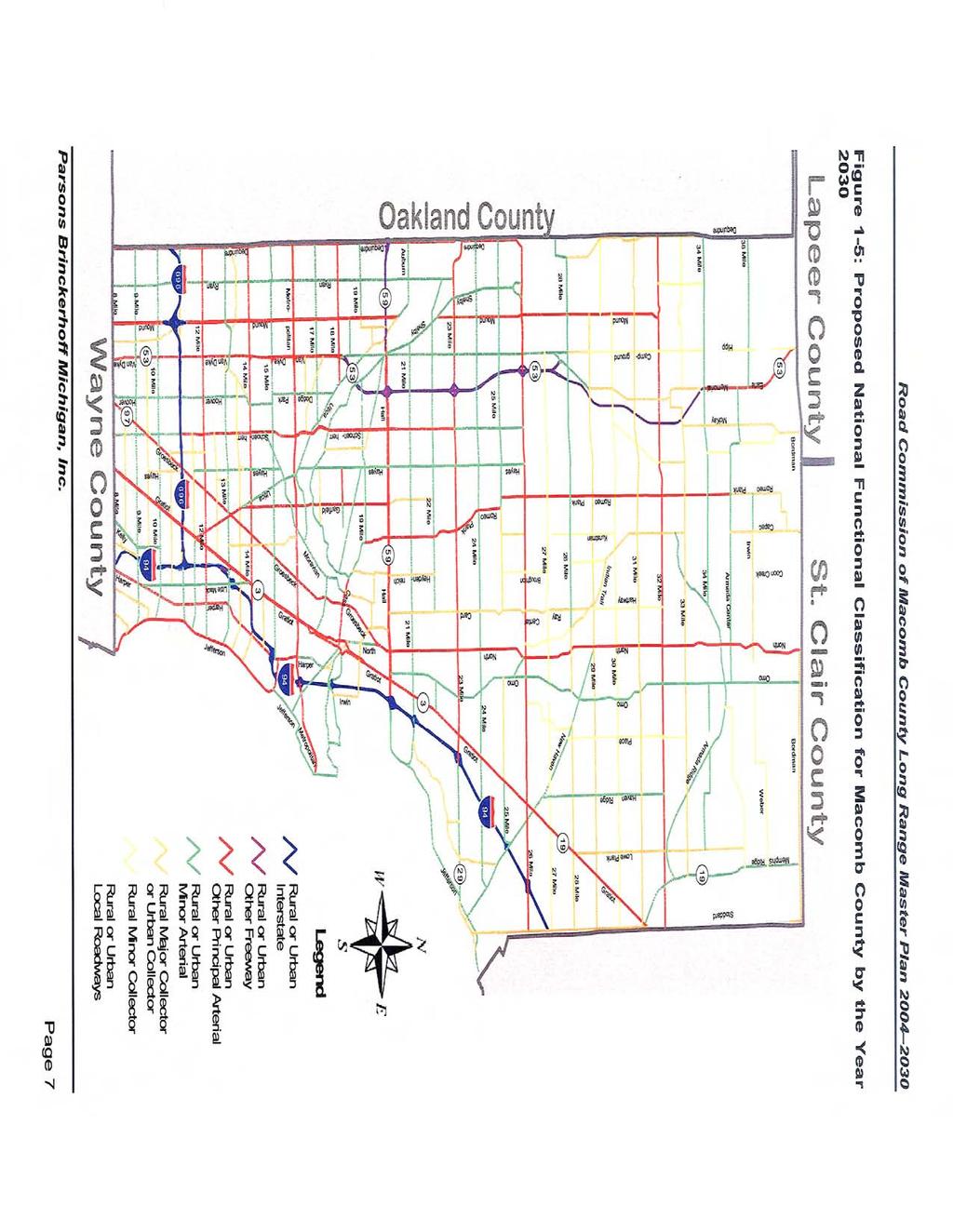
6 List of Figures Figure 1-1: Short-Term Master Plan Recommendations... 2 Figure 1-2: Mid-Term Master Plan Recommendations... 3 Figure 1-3: Long-Term Master Plan Recommendations... 4 Figure 1-4: Proposed Right-of-Way Map for Macomb County by the Year Figure 1-5: Proposed National Functional Classification for Macomb County by the Year Figure 2-1: Macomb County Long Range Master Plan Project... 9 Figure 3-1: Macomb County Existing Land Use Figure 3-2: Macomb County Total Population Figure 3-3: Projected Community Growth within Macomb County Figure 3-4: Macomb County Total Employment Figure 3-5: Projected Employment Growth within Macomb County Figure 3-6: Comparing Population and Employment Data Figure 3-7: Macomb County Functional Classification Map Figure 3-8: Macomb County Average Daily Traffic (Years ) Figure 3-9: Macomb County Roadway Existing Congestion Levels (Years ) Figure 3-10: Critical Crash Summary Figure 3-11: Critical Crash Locations along Major Roadways and Fatal Crash Locations within Macomb County (Years ) Figure 3-12: Tandem Truck Route Map for Macomb County Figure 3-13: Macomb County Pavement Condition Figure 3-14: County Bridges Deficient by Year Figure 3-15: Lenox Township Pedestrian Path Concept Figure 3-16: Macomb County Existing Non-Motorized Plan Figure 3-17: Fixed Line-Haul Bus Routes in Macomb County Figure 3-18: Transportation s Based on Community Plans Figure 4-1: Macomb County Future Land Use Figure 4-2: 2030 No-Build Condition Daily Congestion Levels Figure 4-3: 2030 No-Build Condition PM Peak Hour Congestion Levels Figure 4-4: Future 2030 No-Build Congestion PM Peak Hour Figure 4-5: 2030 Build Condition Daily Congestion Levels Figure 4-6: 2030 Build Condition PM Peak Hour Congestion Levels Figure 4-7: Future 2030 Build Congestion PM Peak Hour Figure 5-1: Short-Term Master Plan Recommendations Figure 5-2: Mid-Term Master Plan Recommendations Figure 5-3: Long-Term Master Plan Recommendations Figure 5-4: Proposed Right-of-Way Map for Macomb County by the Year Figure 5-5: Proposed National Functional Classification for Macomb County by the Year Figure 5-6: Coordinated Development Review Process Figure 5-7: Examples of Context Sensitive Design Figure 5-8: Example of Road Connectivity Figure 5-9: Example of Alternative Access Figure 5-10: Example of Right-of-Way Preservation iv
7 1.0 Executive Summary In the last 30 years Macomb County has grown in population and employment. According to the 2000 Census, Macomb County has a population of 788,149, which represents an increase of 25.9-percent since The County is projected to continue to develop and grow in the next 30 years, as well. It is anticipated that there will be an 18.1-percent increase in total population by the year 2030 when compared to the population in the year With the continuing growth and dynamic changes in Macomb County, an updated Long Range Master Plan is needed. The last County Master Thoroughfare Plan indicating right-of-way requirements was performed in That plan provided the proposed Inter-County Highway Plan right-ofway requirements for major roads. According to the Road Commission of Macomb County s statistics, there are 1,174 county primary and 678 state trunkline lane miles within Macomb County. The Road Commission of Macomb County (RCMC) constructs, operates, and maintains approximately 3,500 lane miles of county, primary, and local roads within Macomb County. RCMC also maintains over 750 bridges and drain structures, more than 950 traffic signals, and 60,000 signs. Macomb County is experiencing tremendous growth in areas that have long been rural in nature. The County must now expand their infrastructure into those areas. In addition to the expansion needs, the infrastructure in well-established areas is in need of repair or replacement. An existing conditions summary describes the existing land use, population and employment trends, transportation facilities, right-of-way, traffic volumes and capacity, crashes, truck routes, pavement sufficiency, bridge conditions, transit, and non-motorized facilities. Utilizing the 2030 land use and roadway data in the SEMCOG TRANPLAN model, an analysis was run for the future 2030 No Build Condition and the 2030 Build Condition. The existing SEMCOG TIP has identified projects for Macomb County that will alleviate some congestion, but based on the SEMCOG TRANPLAN model congestion levels will still exist. A number of roadway improvements were tested to assess whether the additional improvements would continue to reduce traffic congestion. A list of roadway widenings, extensions, and pavings were tested to assess the 2030 future roadway needs. These additional roadway improvements would reduce the heavy congestion by 10-percent, and increase more roads with little or no congestion by 10-percent. The recommendations for improvements in Macomb County are listed in Chapter 5. Figure 1-1 provides the short-term master plan recommendations, Figure 1-2 provides the mid-term master plan recommendations, and Figure 1-3 provides the long-term master plan recommendations. The actual list of each recommendation is contained in chapter 5. Due to land development patterns within Macomb County, the southern half of the county has different transportation needs than the northern half. Based on the results of the Existing and No-Build Conditions analyses, roadway improvements were recommended and ranked based on when they should be implemented: short-term, mid-term, and long-term. Page 1
8
9
10
11 Preliminary cost estimates were provided for each of the recommendations. The estimated year 2004 cost for the short-term recommendations is $298 million. The estimated year 2004 cost for the mid-term recommendations is $472 million. The estimated year 2004 cost for the longterm recommendations is $382 million. The total short-term, mid-term, and long-term recommendation cost estimate to address the needs to the year 2030 is estimated at $1,152 million. A portion of these costs would be the responsibility of the cities. Proposed right-of-way and roadway classification updates are proposed to address the plan to the year Figures 1-4 and 1-5 provide the right-of-way and roadway functional classifications for the roadway system in Based on the functional classification of the roadway, the following right-of-way is recommended for the 2030 plan: 66-feet for local roadways 86-feet for collector roadways 100-feet for four-lane undivided roadways 120-feet for five-lane roadways 150-feet for four-lane divided roadways with a median 204-feet for major primary roadways on national highway system or for eight-lane divided roadways The most cost effective method for developing and maintaining a coordinated and safe transportation system is to form equal partnerships between the County and local levels of government. The County s main role is to maintain roads, bridges, traffic signs, traffic signals, and to fund improvements. The role of local municipalities is to develop plans and guidelines that will influence traffic flow and develop land use regulations during the review of development proposals and site plans. Additional areas to continue the coordination between agencies are in residential road design, access management, traffic impact studies, right-of-way preservation, corridor planning and management, and local community master plans. These recommendations and agency coordination will well serve Macomb County as it grows and prospers through the year Page 5

12
13
14 2.0 Introduction The Road Commission of Macomb County (RCMC) constructs, operates, and maintains approximately 3,500 lane miles of county, primary, and local roads within Macomb County. RCMC also maintains over 750 bridges and drain structures, more than 950 traffic signals, and 60,000 signs. In the last 30 years Macomb County has grown in population and employment. According to the 2000 Census, Macomb County has a population of 788,149, which represents an increase of 25.9-percent since The County is projected to continue to develop and grow in the next 30 years, as well. It is anticipated that there will be an 18.1-percent increase in total population by the year 2030 when compared to the population in the year Due to the growth and development a long range transportation master plan will assist in guiding the RCMC for the next 25 years. 2.1 Project History With the continuing growth and dynamic changes in Macomb County, an updated Long Range Master Plan is needed. The last County Master Thoroughfare Plan indicating right-of-way requirements was performed in That plan provided the proposed Inter-County Highway Plan right-of-way requirements for major roads. The map for the plan identified rights-of-way between 120-feet to 300-feet. Macomb County is experiencing tremendous growth in areas that have long been rural in nature. The County must now expand their infrastructure into those areas. In addition to the expansion needs, the infrastructure in well-established areas is in need of repair or replacement. This Project Plan will update and expand the scope of the 1982 plan to create a Long Range Master Plan for This Long Range Master Plan will not only include planned rightsof-way, but also will assist in identifying projects to be planned, improved, and/or expanded in the transportation system. 2.2 Project Area The project area for the Macomb County Long Range Master Plan is bounded by Bordman to the north, M-102 to the south, Dequindre to the west, and Lake St. Clair and County Line/Stoddard to the east. Figure 2-1 illustrates the project area used for the plan. Page 8
15 Figure 2-1: Macomb County Long Range Master Plan Project Lapeer County St. Clair County Memphis Bruce Twp Armada Twp Richmond Twp Richmond Washington Twp Ray Twp Lenox Twp Oakland County Shelby Twp Utica Macomb Twp Mount Clemens Chesterfield Twp New Baltimore Sterling Heights Fraser Clinton Twp Harrison Twp Center Line Warren Roseville Eastpointe St. Clair Shores Wayne County Source: Road Commission of Macomb County Page 9
16 3.0 Existing Conditions This chapter describes the existing land use, population and employment trends, transportation facilities, right-of-way, traffic volumes and capacity, crashes, truck routes, pavement sufficiency, bridge conditions, transit, and non-motorized facilities. 3.1 Land Use Macomb County is situated north of the city of Detroit, along the western shore of Lake St. Clair. Development of the county has historically been influenced by transportation corridors and waterways. Historic community centers such as Mt. Clemens and Utica were established along the Clinton River. Over the years these older community centers have become surrounded by more modern suburban development moving northward from Detroit. Figure 3-1 provides the existing land use map. This section of the report summarizes land use throughout Macomb County, including residential, commercial, industrial, institutional, and mixed use Residential Traditionally, residential development was centered around older communities such as Mt. Clemens, Utica, New Haven, and Richmond as well as along the shoreline of Lake St. Clair. Northward suburban development from Detroit has followed the shoreline and major transportation corridors including Mound Road, Van Dyke Avenue, Groesbeck Highway, Gratiot Avenue, and Jefferson Avenue. During the development boom that followed World War II and continuing through the 1960 s, suburban residential development occurred in the inner-ring suburbs of St. Clair Shores, Eastpoint, Roseville, Fraser, Centerline and Warren. During the 1970 s this development continued northward into Sterling Heights, Clinton Township, and Harrison Township. Suburbanization slowed somewhat during the economic downturn of the early 1980 s; however, in the past two decades since 1983 the pace of development has increased. Much of the more recent residential development has been occurring in Chesterfield, Macomb, and Shelby townships; with Macomb Township as currently the fastest growing community in the State of Michigan. Townships in the northern portion of the county have historically been dominated by agricultural uses, but are now beginning to experience increased pressures as development moves northward. Significant residential development is expected to continue in Macomb County. Much of the development within the near future is expected within the central portion of the county in Chesterfield, Macomb, and Shelby townships. Additional development is expected within Lenox Township along the Gratiot Avenue corridor and Washington Township along the M-53 corridor. In later years, development of the northern townships of Ray, Bruce, Armada, and Richmond will occur; however these areas are planned to remain under agricultural and low density rural residential use. Infill development is planned in the southern portion of the county. This may include redevelopment of areas with higher density housing. Infill development will also occur within older community centers such as Mt. Clemens and Utica. Page 10
17 Figure 3-1: Macomb County Existing Land Use Lapeer County St. Clair County Memphis Bruce Twp Armada Twp Richmond Twp Richmond Oakland County Washington Twp Center Line Shelby Twp Utica Sterling Heights Warren Mount Clemens Fraser Ray Twp Macomb Twp Clinton Twp Roseville Eastpointe Wayne County St. Clair Shores Source: Southeast Michigan Council of Governments (SEMCOG) Lenox Twp Chesterfield Twp Harrison Twp New Baltimore Legend Commercial and Office Cultivated, Grassland, and Shrub Cultural, Outdoor Recreation, and Cemetery Extractive Industrial Institutional Multiple-family Residential Single-family Residential Transportation, Communication, and Utility Under Development or Losing Housing Water Woodland and Wetland Page 11
18 3.1.2 Commercial Similar to residential development, commercial and industrial development has followed major transportation corridors northward from Detroit. Historically, Gratiot Avenue has been the major commercial corridor of the county with major commercial uses through the communities of Eastpoint, Roseville, Clinton Township, and Mt. Clemens, including the Macomb Regional Mall. Other commercial corridors include Harper Avenue through St. Clair Shores, Groesbeck Highway through Warren, Roseville, and Fraser and Van Dyke Avenue through Warren, Centerline, Sterling Heights, Utica, and Shelby Township. While historic transportation corridors radiated outward from Detroit, the east-west M-59 corridor has emerged in recent years as the primary regional retail corridor in the county. Development of this corridor began in the 1970 s with the development of the Lakeside Regional Mall at the northern edge of Sterling Heights and has continued with large scale commercial development spanning nearly the entire length of this corridor from Utica east to I-94. Commercial development is planned to continue along the major roadway corridors. M-59 will see the greatest amount of additional commercial development as this corridor builds-out. Future commercial in the northern portion of the county is planned along the major transportation corridors of Gratiot Avenue and Van Dyke Avenue. Some infill commercial development is expected in the southern portion of the county, predominantly through the redevelopment of older strip commercial sites Industrial The two major industrial areas within Macomb County are along the Mound Road/Van Dyke Avenue and Groesbeck Highway corridors. Mound Road/Van Dyke Avenue through Warren and Sterling Heights is the most intensively developed corridor with major industrial facilities operated by General Motors, Ford, and Daimler-Chrysler, including the 7,500,000 square foot General Motors Tech Center in Warren. In addition to major facilities operated by the Big- Three auto-manufactures, there are numerous other large industrial uses and business parks housing smaller industrial uses. Substantial areas have been planned for industrial development along the Gratiot Avenue corridor extending from Mt. Clemens to New Haven. Additional areas have been planned for future industrial development in Shelby, Macomb, Bruce, and Washington townships Mixed Use Downtowns There are several traditional downtowns within Macomb County that contain a mixture of uses. These include Mt. Clemens, Centerline, Utica, New Haven, Romeo, Richmond, and Armada. Most of these historic communities have traditional urban or village cores with a variety of uses, small lots, buildings built up-to the front lot line, and a quaint historic appearance. The mixture of uses closely-knit into a pedestrian-friendly environment creates an atmosphere of vitality. The structures within the smaller downtowns are predominantly a mixture of one to three story buildings. Mt. Clemens is more built-up with high-rise office buildings more characteristic of a larger city. The downtown streetscapes are characterized with wider sidewalks, pedestrian furniture, formal street trees, ornamental streetlights and on-street parking. Each of these downtowns include traditional main streets and key landmark buildings that define each community as a distinct place. Page 12
19 3.1.5 Institutional The Huron-Clinton Metropolitan Authority operates three regional parks in Macomb County: Stony Creek Metropark in Shelby and Washington townships, Wolcott Mill Metropark in Ray Township, and Metropolitan Beach Metropark on Lake St. Clair in Harrison Township. The Rochester-Utica State Recreation Area is located in Shelby Township and the Wetzel State Park is located in Lenox Township. The Macomb Community College s Central Campus is located on M-59 in Clinton Township, with other campuses located in Warren, Fraser, and Romeo. The Romeo Airport is located in Ray Township. The Selfridge Air National Guard Base is located in Harrison Township. 3.2 Population and Employment Trends This section of the report reviews the existing and future population and employment in Macomb County Population According the U.S. Census, Macomb County has experienced a 26-percent increase in population growth over the past 30 years. In 1970 the County s population was 626,204 and this grew by 25.9-percent by the year Population is expected to continue to increase by the year It is anticipated that there will be an 18.1-percent increase in total population by the year 2030 when compared to the population in the year This equates to a percent increase in total population between the years 1970 and Figure 3-2 provides the total population within Macomb County. A breakdown of the communities within Macomb County indicates that based on forecasted population growth trends from 1990 to 2030, the fastest growing communities will be: Macomb Township percent growth Bruce Township percent growth Washington Township percent growth Lenox Township percent growth Richmond Township percent growth Table 3-1 provides the population growth estimates for the communities within Macomb County. The population forecasts indicate that significant growth is expected to occur in Macomb County by the year 2030; however, a breakdown in the population data indicates that the sharpest population increase occurred between 1990 and Significant population growth is anticipated between 2000 and 2030 with the fastest growing communities continuing to be Macomb Township, Bruce Township, Washington Township, Lenox Township, and Richmond Township. Figure 3-3 provides the projected community growth within Macomb County. Page 13
20 Figure 3-2: Macomb County Total Population 1,000, , , , , , , , , , , , , , , Census Year Total Population Source: U.S. Census Page 14
21 Table 3-1: Population Estimates within Macomb County Road Commission of Macomb County Long Range Master Plan Population Community 1990 Census 2000 Census 2030 Forecast Change Change Change % Change % Change % Change Macomb Township 22,714 50, ,247 27,764 60,769 88, % 120.4% 389.8% Bruce Township 4,193 6,395 12,362 2,202 5,967 8, % 93.3% 194.8% Washington Township 11,386 17,122 33,187 5,736 16,065 21, % 93.8% 191.5% Lenox Township 3,069 5,362 8,554 2,293 3,192 5, % 59.5% 178.7% Richmond Township 2,528 3,416 6, ,811 3, % 82.3% 146.3% Chesterfield Township 25,905 37,405 62,149 11,500 24,744 36, % 66.2% 139.9% New Baltimore 5,798 7,405 13,598 1,607 6,193 7, % 83.6% 134.5% Armada Township 2,943 3,673 6, ,525 3, % 68.7% 110.6% Shelby Township 48,655 65,159 92,699 16,504 27,540 44, % 42.3% 90.5% Ray Township 3,230 3,740 6, ,315 2, % 61.9% 87.5% Richmond 4,141 4,896 7, ,548 3, % 52.0% 79.8% Clinton Township 85,866 95, ,040 9,782 12,392 22, % 13.0% 25.8% Fraser 13,899 15,297 15,708 1, , % 2.7% 13.0% Sterling Heights 117, , ,935 6, , % 0.4% 6.0% Utica 5,081 4,577 5, % 13.4% 2.2% Harrison Township 24,685 24,461 24, % 1.7% 0.8% Center Line 9,026 8,531 8, % -5.0% -10.2% Warren 144, , ,348-6,617-9,899-16, % -7.2% -11.4% Eastpointe 35,283 34,077 31,007-1,206-3,070-4, % -9.0% -12.1% Mount Clemens 18,405 17,312 15,763-1,093-1,549-2, % -8.9% -14.4% Memphis (Macomb only) % -6.9% -16.2% Roseville 51,412 48,129 42,552-3,283-5,577-8, % -11.6% -17.2% St. Clair Shores 68,107 63,096 55,009-5,011-8,087-13, % -12.8% -19.2% Source: Southeast Michigan Council of Governments Page 15
22 Figure 3-3: Projected Community Growth within Macomb County 425.0% Projected Community Growth 400.0% 375.0% 350.0% 325.0% 300.0% % Change % Change % Change 275.0% 250.0% 225.0% 200.0% 175.0% 150.0% 125.0% 100.0% Percent Change 75.0% 50.0% 25.0% 0.0% Macomb Township Bruce Township Washington Township Lenox Township R ichmond Township Chesterfield Township New Baltimore Armada Township Shelby Township Ray Township Richmond C linton Township Fraser Sterling Heights U tica Harrison Township Center Line Warren Eastpointe Mount Clemens Memphis (Macomb only) R oseville St. C lair Shores -25.0% -50.0% Source: Southeast Michigan Council of Governments Community Page 16
23 3.2.2 Employment Macomb County has experienced 83-percent increase in employment growth over the past 30 years. In 1970 the County s total employment was 208,524 which grew by 83.1-percent by the year Figure 3-4 provides the total employment within Macomb County. Figure 3-4: Macomb County Total Employment 400, , , , , , , , , , ,000 50, Total Employment Source: Southeast Michigan Council of Governments Based on forecasted employment trends in Macomb County from 1990 to 2030, the fastest growing employment centers are: Macomb Township percent growth Armada Township percent growth Lenox Township percent growth Washington Township percent growth Bruce Township percent growth Table 3-2 provides the employment estimates for the communities within Macomb County. The employment forecasts indicate that significant growth is expected to occur in Macomb County by the year 2030; however, a breakdown in the employment data indicates that the sharpest population increase occurred between 1990 and Significant employment growth is anticipated between 2000 and 2030 with the fastest growing communities continuing to be Macomb Township, Armada Township, Lenox Township, Washington Township, and Bruce Township. Figure 3-5 provides the projected employment growth within Macomb County. Page 17
24 Table 3-2: Employment Estimates within Macomb County Employment Community 1990 Census 2000 Census 2030 Forecast Change Change Change % Change % Change % Change Macomb Township 1,775 3,150 9,678 1,375 6,528 7, % 207.2% 445.2% Armada Township , ,208 1, % 191.4% 442.5% Lenox Township 477 1,008 2, ,450 1, % 143.8% 415.3% Washington Township 2,236 3,913 9,259 1,677 5,346 7, % 136.6% 314.1% Bruce Township 1,575 2,362 4, ,851 2, % 78.4% 167.5% Ray Township , % 69.5% 163.1% Memphis (Macomb only) % 10.9% 146.9% Shelby Township 12,086 16,783 26,392 4,697 9,609 14, % 57.3% 118.4% Richmond 2,038 2,664 4, ,561 2, % 58.6% 107.3% Richmond Township , % 55.7% 98.4% New Baltimore 2,809 3,670 5, ,682 2, % 45.8% 90.5% Harrison Township 5,334 7,908 9,910 2,574 2,002 4, % 25.3% 85.8% Chesterfield Township 7,993 11,625 14,660 3,632 3,035 6, % 26.1% 83.4% Clinton Township 25,682 36,449 43,774 10,767 7,325 18, % 20.1% 70.4% Fraser 10,510 14,348 15,251 3, , % 6.3% 45.1% Utica 5,633 6,765 7,577 1, , % 12.0% 34.5% Sterling Heights 55,757 68,008 74,772 12,251 6,764 19, % 9.9% 34.1% Center Line 7,067 9,415 8,454 2, , % -10.2% 19.6% Mount Clemens 24,537 28,097 28,209 3, , % 0.4% 15.0% Eastpointe 9,608 10,523 10, , % 3.3% 13.2% St. Clair Shores 19,943 21,569 21,239 1, , % -1.5% 6.5% Warren 107, , ,985-6, , % 0.8% -5.0% Roseville 25,327 22,865 19,100-2,462-3,765-6, % -16.5% -24.6% Source: Southeast Michigan Council of Governments Page 18
25 Figure 3-5: Projected Employment Growth within Macomb County 500.0% 450.0% 400.0% 350.0% Projected Employment Growth % Change % Change % Change 300.0% 250.0% 200.0% 150.0% 100.0% Percent Change 50.0% 0.0% Macomb Township Armada Township Lenox Township Washington Township Bruce Township Ray Township Memphis (Macomb only) Shelby Township Richmond Richmond Township New Baltimore Harrison Township Chesterfield Township Clinton Township Fraser Utica Sterling Heights Center Line Mount Clemens Eastpointe St. Clair Shores Warren Roseville -50.0% Source: Southeast Michigan Council of Governments Community Page 19
26 Figure 3-6 compares the forecasted population and employment growth from 2000 to the year The population in Macomb County is expected to grow twice as fast as the rest of southeast Michigan. The population in northern Macomb County, north of M-59, is expected to grow by 83-percent from the year 2000 to the year 2030; this is six times as fast as the rest of southeast Michigan. While employment in Macomb County is not expected to grow as fast as the rest of southeast Michigan, employment in northern Macomb County is expected to skyrocket, with 104-percent increase in employment. Figure 3-6: Comparing Population and Employment Data Population and Employment Growth from 2000 to % 104% 100% 83% 80% 60% 40% 20% 13% 46% 20% 36% 0% Southeast Michigan Macomb County Northern Macomb County U.S. Census Population Employment Source: 3.3 Transportation Facilities According to the Road Commission of Macomb County s statistics, there are 1,174 county primary and 678 state trunkline lane miles within Macomb County Right-of-Way The last County Master Thoroughfare Plan indicating right-of-way requirements was performed in That plan provided the proposed Inter-County Highway Plan right-of-way requirements for major roads. The map for the plan identified rights-of-way between 120-feet to 300-feet. Page 20
27 3.3.2 Volumes/Capacity This section describes the national functional classification system, average daily traffic, and roadway travel flow characteristics within Macomb County. National Functional Classification National Functional Classification (NFC) is a planning tool which federal, state, and local transportation agencies have used since the late 1960's. The Federal Highway Administration (FHWA) developed this system of classifying all streets, roads, and highways according to their function. There are four different roadway classifications: principal arterials, minor arterials, collectors, and local roads. Principal arterials are at the top of the NFC hierarchial system. Principal arterials generally carry long distance, through-travel movements, and also provide access to important traffic generators, such as major airports or regional shopping centers. Examples of principal arterials in Macomb County are I-94, I-696, M-59, and M-19, and are typically the state trunklines. Minor arterials are similar in function to principal arterials, except they carry trips of shorter distance and to lesser traffic generators. Minor arterials in Macomb County include 10 Mile Road, 15 Mile Road, Hayes Road, and North Avenue. Collectors tend to provide more access to property than do arterials. Collectors also funnel traffic from residential or rural areas to arterials. Examples of this in Macomb County are Martin Road and typically the half-mile roads in the southern part of the county. Local roads primarily provide access to property. Examples of this are residential streets and the lightly-traveled county roads. FHWA research led to guidelines regarding the percentage of streets and roads that should be in each of the functional classification categories. Different guidelines exist for urban and rural areas, because travel characteristics and density of development differs between the two land uses. Table 3-3 summarizes the percentage guidelines recommended by the FHWA. Table 3-3: FHWA Functional Classification Percentage Guidelines Functional Classification Urban Rural Principal Arterials 5 10 % 2 4 % Principal Arterials plus Minor Arterials % 6 12 % Collectors 5 10 % 20 25% Local Roads % % Source: Federal Highway Administration The Michigan Department of Transportation has further defined the National Functional Classification by creating subcategories for principal arterials. These include interstates, other freeways, and other principal arterials. The interstates in Macomb County include I-94 and I The other freeway subcategory includes M-59 and M-53, and the other principal arterials include roadways such as Gratiot Avenue, Groesbeck Avenue, and Metropolitan Parkway. Page 21
28 Figure 3-7 illustrates the Macomb County Functional Classification Map based on the Michigan Department of Transportation categories. Table 3-4 summarizes the FHWA functional classification percentages for Macomb County roadways. Table 3-4: Macomb County Functional Classification Percentages Functional Classification Urban Rural Principal Arterials 14 % 3 % Principal Arterials plus Minor Arterials 23 % 6 % Collectors 4 % 28 % Local Roads 72 % 66 % Source: Michigan Department of Transportation Most of the percentages within Macomb County are within the FHWA percentage guidelines with a few exceptions. The urban principal arterial percentage in Macomb County is above the guideline and the percentage of urban collectors is on the lower side of the guideline. The percentage of rural principal arterials plus minor arterials is on the low side of the guideline and the rural collector percentage is above the FHWA guideline. Average Daily Traffic Most times roadway classification is based on existing traffic counts and occasionally roadways need to have a higher roadway classification based on traffic counts. The Road Commission of Macomb County currently has a three-year rotating traffic counting program for all county roads. The traffic counting program ensures that all county roads are counted at least once in a threeyear period. This ensures that roadways are classified correctly and that roadway traffic growth is monitored efficiently. The County keeps an average daily traffic map detailing 24-hour traffic volumes on most county roadways. Figure 3-8 summarizes the average daily traffic in Macomb County, Michigan. The average daily traffic volumes were a collection of traffic counts collected from the Road Commission of Macomb County and the Southeast Michigan Council of Governments (SEMCOG). SEMCOG maintains a traffic count inventory using counts from all seven counties as well as counts from the Michigan Department of Transportation and other municipalities. For those roadways which did not have a traffic count, the average daily traffic volumes were taken from the 2000 SEMCOG TRANPLAN model. This travel demand forecasting model uses socio-economic information for the seven county region to predict traffic volumes for higher classification roadways. Page 22
29
30
31 Table 3-5 summarizes the average daily traffic volumes for varying types of roadway classification in Macomb County. Table 3-5: Average Daily Traffic Volumes by Functional Class Functional Classification Urban Rural Interstate Freeway 60, ,000 30,000 60,000 Other Freeway 50,000 80,000 15,000 50,000 Principal Arterials 20,000-70,000 10,000 45,000 Minor Arterials 10,000-50,000 8,000 30,000 Collectors 5,000 30,000 2,500 20,000 Local Roads 0 10, ,000 Source: Roadway Travel Flow Characteristics Congestion along roadways can be determined using the average daily traffic volumes and the capacity that is available along a roadway. Roadways can typically carry approximately 2,000 to 2,400 vehicles per lane per hour, at a maximum, without any signalization and at optimal roadway conditions. Once signals and driveways are added along the roadways, capacity is reduced significantly. Higher classification roadways have greater capacity due to less signals and driveways, while local roadways have the least capacity per lane. The SEMCOG roadway capacities were utilized along with the traffic volumes to determine the volume-to-capacity (V/C) ratio for roadway segments. The V/C ratio is the ratio of vehicles traveling the roadway (demand flow rate) to the capacity of the roadway segment. The Transportation Handbook, by the Institute of Transportation Engineers (ITE) states that roadway capacity represents the maximum number of vehicles that can pass a given point during a specified time period with reasonable expectancy under prevailing traffic and environmental conditions. The V/C ratio indicates how the roadway is operating. The V/C can be equated to a level of service (LOS) which is another way of evaluating the roadway system. There are six levels of service, a condition as perceived by users of the roadway system. Level of service is similar to a grading scale where LOS A represents uncongested conditions and LOS F represents a breakdown in traffic flow. Table 3-6 provides definitions for the V/C ratio and the corresponding level of service. Page 25
32 Table 3-6: Volume-to-Capacity Level of Service Definitions Level of Interpretation Service Uncongested operations. The operation of vehicles is A virtually unaffected by the presence of other vehicles. Very light congestion. Travel speeds tend to be the B same as in LOS A, but drivers have slightly less freedom to maneuver. Light congestion; occasional backups. The ability to C maneuver within the traffic stream is affected by the presence of other vehicles. Significant congestion. The ability to maneuver is D severely restricted because of congestion. Travel speed begins to be reduced by increasing volumes. Severe congestion. Operations are at or near capacity E and are quite unstable. Total breakdown, stop-and-go operation. Vehicles are arriving at a greater rate than they can discharge. F Vehicles experience brief periods of movement followed by stoppages. Source: ITE Transportation and Traffic Engineering Handbook V/C Ratio Less Than and Greater Figure 3-9 illustrates the existing congestion levels on roadways within Macomb County. Some of the heaviest congested roadways in Macomb County are Hall Road, 23 Mile Road, Mound Road, Van Dyke Road, Metropolitan Parkway, Cass Avenue, Romeo Plank Road, and 21 Mile Road Crashes This section of the report provides both system-wide and intersection-level crash summaries for Macomb County. System-Wide Level According to the Office of Highway Safety Planning (OHSP), approximately 71.0-percent of the State of Michigan population are licensed drivers and 86.1-percent have vehicles registered in Michigan. Of the licensed drivers, approximately 9.7-percent were involved in crashes in The estimated vehicle mileage traveled in the State of Michigan in 2001 was approximately 96.4 billion miles, an increase of 1.6-percent when compared to the year However, the death rate per 100 million vehicle miles decreased from 1.5 in the year 2000 to 1.4 in the year 2001 (approximately a 6.7-percent decrease). On a state-wide basis, traffic crashes decreased in the year 2001 when compared to year 2000 values. Page 26
33 Within the State of Michigan in 2001 there were a total of 400,813 crashes. Of the total number of crashes, there were 1,206 fatal crashes where 1,328 persons were killed and 80,922 injury crashes where 112,294 persons were injured. The remaining 318,685 crashes were property damage only. Therefore, of the total number of crashes in Michigan, 0.3-percent were fatal crashes, 20.2-percent were injury crashes, and 79.5-percent were property damage only crashes. Although these numbers may seem high, when compared to the year 2000 the OHSP indicates that deaths decreased by 3.9-percent, persons injured by 7.8-percent, and total reported crashes decreased by 5.7-percent. In addition to statewide statistics, the OHSP provides statistics on a county level. Within Michigan there are 83 counties. The top five counties with the greatest number of crashes are listed in Table 3-7. The rankings correlate to the county population (higher population, higher number of crashes). The statistics show that Wayne County has the largest number of total, fatal, injury, and property damage only crashes, followed by Oakland and Macomb Counties. In 2001, Macomb County ranked third in the State of Michigan based on total population and total number of crashes. Of the 25,977 total crashes, there were 66 fatal crashes where 69 persons were killed and 5,809 injury crashes where 7,901 persons were injured. The remaining 20,102 crashes were property damage only. Therefore, of the total number of crashes in Macomb County, 0.3-percent were fatal crashes, 22.4-percent were injury crashes, and percent were property damage only crashes. The County s percent fatal crashes matches the State of Michigan s average, with the injury crashes slightly higher and the property damage only slightly lower. Within Macomb County, approximately 70.9-percent of the total crashes occur on the local roadways, 18.9-percent on state routes, and 10.1-percent on interstates. Only 0.1-percent of the total crashes occur on US routes. Within the State of Michigan, 71.2-percent of the total crashes occur on the local roadways, 13.5-percent on state routes, 10.1-percent on interstates, and 5.2-percent on US routes. Based on these percentages, Macomb County statistics are similar to the State of Michigan. In 2001, there were approximately 3.3 crashes per 100 persons living in Macomb County. The statewide average was 4.0 crashes per 100 persons. Macomb County has the lowest number of crashes per 100 persons within the five counties listed in Table 3-7. This indicates that Macomb County has the least number of crashes per population than the other four counties in the top five. Intersection Level Traffic crashes cause property damage, injuries, and loss of life and also add to driver delay and frustration. An intersection crash analysis was performed for major intersections within Macomb County. The three most recent and complete years of crash data (for years 1997, 1998, and 1999) were obtained from the Southeast Michigan Council of Governments (SEMCOG). The data included the total number of crashes, fatalities, Injury A, Injury B, Injury C, property damage only. Page 28
34 Table 3-7: Reported 2001 Traffic Crashes for the State of Michigan and for the Five Highest Counties in Michigan County 2000 Census Total Population All Fatal Injury Property Damage Only Interstate US Route State Route Local Street Persons Killed Persons Injured Number of Crashes per 100 Persons Wayne 2,061,162 80, ,707 61,689 7,854 2,302 6,863 63, , Oakland 1,194,156 45, ,226 35,437 5,357 1,967 4,929 33, , Macomb 788,149 25, ,809 20,102 2, ,914 18, , Kent 574,335 25, ,182 20,378 2,452 1,158 4,667 17, , Genesee 436,141 15, ,720 11,661 1, ,597 12, , Michigan 9,938, ,813 1,206 80, ,685 40,590 20,693 54, ,387 1, , Source: Office of Highway Safety Planning, 2001 Michigan Traffic Crash Facts Page 29
35 The definitions of the injury severity classification used in standard UD-10 forms were aggregated in the data provided by SEMCOG. The State of Michigan UD-10 Traffic Crash Report Instruction Manual, revised September 1994 uses the following classifications. Fatal Injury (K): Any injury that results in death due to a motor vehicle traffic crash. Incapacitating Injury (A): Any injury, other than fatal, which prevents the injured person from walking, driving, or normally continuing the activities which he or she was capable of performing prior to the motor vehicle traffic crash. Non-incapacitating Evident Injury (B): Any injury, other than fatal and incapacitating, which is evident at the scene of the crash. Possible Injury (C): Any injury reported or claimed which is not a fatal, incapacitating, or nonincapacitating evident injury. The Crash Rate and the Crash Frequency methods were utilized in identifying whether the intersections analyzed were critical crash locations. The Crash Rate Method evaluates the number of crashes based on the Average Daily Traffic (ADT) while the Crash Frequency Method ranks locations by descending crash frequency; that is the average number of crashes per year. (Number_of_Crashes) * (1,000,000) Crash_Rate = (Average_Daily_Entering Volume) * (365Days/Year) * (Number_of_Years) The Crash Frequency Method does not take into account the differing amounts of traffic at the locations, where the Crash Rate Method does. The Crash Frequency Method assigns ranking solely on the number of crashes, even if the location has a relatively low number of crashes for its traffic volume. These two methods, in conjunction with one another, provide a fairly complete picture of traffic safety conditions. (Total_Number_of_Crashes) Crash_Freq uency = (Number_of_Years) The Critical Intersection Crash Rates, Frequencies, and Casualty Ratios By Area Type table produced by SEMCOG in September 1997 for an urban area was utilized to obtain the critical crash thresholds for frequency and rate based on the ADT entering the intersection. Based on these thresholds, critical crash locations were identified. An intersection was considered to be a critical crash location if the intersection exceeded the threshold for both rate and frequency based on the ADT entering the intersection. Forty-nine intersections within Macomb County were considered to be critical crash locations based on exceeding the thresholds for both rate and frequency based on the ADT entering the intersection. Table 3-8 summarizes the total number of crashes with injuries or property damage for the critical crash locations within Macomb County between 1997 and The overall crash rate and crash frequency are also displayed. Page 30
36 Table 3-8: Critical Crash Location Summary Intersection Total Crashes Three Year Crash Data (Years ) Fatal Crashes Injury A Injury B Injury C Property Damage Only Crash Rate Crash Frequency 10 Mile Road Dequindre Road Mile Road Dequindre Road Mile Road (EB I-696 SD) Gratiot Avenue Mile Road (EB I-696 SD) Groesbeck Highway Mile Road (EB I-696 SD) Van Dyke Avenue Mile Road (WB I-696 SD) Groesbeck Highway Mile Road (WB I-696 SD) Van Dyke Avenue Mile Road Dequindre Road Mile Road Gratiot Avenue Mile Road Groesbeck Highway Mile Road Hoover Road Mile Road Ryan Road Mile Road Gratiot Avenue Mile Road Hoover Road Mile Road Ryan Road Mile Road Dequindre Road Mile Road Groesbeck Highway Mile Road Groesbeck Highway Mile Road Schoenherr Road Mile Road Utica Road Mile Road Gratiot Avenue Mile Road Jefferson Avenue Mile Road (WB) EB I-94 On-Ramp Mile Road Gratiot Avenue Dequindre Road 17 Mile Road Dequindre Road EB I-696 SD Page 31
37 Table 3-8: Critical Crash Location Summary, Continued Intersection Total Crashes Three Year Crash Data (Years ) Fatal Crashes Injury A Injury B Injury C Property Damage Only Crash Rate Crash Frequency Division Road Main Street Fairchild Road 21 Mile Road Frazho Road Gratiot Avenue Garfield Road 19 Mile Road Gratiot Avenue 21 Mile Road Gratiot Avenue Hall Road Groesbeck Highway Cass Avenue Groesbeck Highway Metropolitan Parkway Hayes Road 21 Mile Road Hayes Road Hall Road Main Street 32 Mile Road (St. Clair) Masonic Boulevard Gratiot Avenue Masonic Boulevard Groesbeck Highway North Avenue 21 Mile Road Romeo Plank Road Hall Road Schoenherr Road Hall Road Utica Road Groesbeck Highway Van Dyke Avenue 18 Mile Road Van Dyke Avenue 21 Mile Road Van Dyke Avenue 26 Mile Road Van Dyke Avenue Hall Road Van Dyke Avenue Riverland Drive WB I-94 Off-Ramp Metropolitan Parkway Note: Critical crash location is based on the intersection crossing the critical crash threshold for both crash frequency and crash rate. Source: Southeast Michigan Council of Governments Page 32
38 Figure 3-10 graphically summarizes the critical crash intersection data along the major roadways within Macomb County. The figure indicates that the predominant injury type during the three-year analysis period is property damage only (PDO). PDO crashes represent the largest percentage of injury crashes (73.31-percent), followed by Injury C crashes ( percent), Injury B crashes (5.26-percent), and Injury A crashes (1.96-percent). Fatal crashes represent 0.10-percent of the injury crashes on the major roadways within Macomb County. Figure 3-10: Critical Crash Summary Critical Crash Location Summary Fatal Injury A Injury B Injury C Property Damage Only Injury C, 19.38% Property Damage Only, 73.31% Injury B, 5.26% Injury A, 1.96% Fatal, 0.10% Source: Southeast Michigan Council of Governments Figure 3-11 graphically displays the 49 critical crash locations along the major roadways within Macomb County and identifies intersections that have had fatal crashes between 1997 and Crash Summary Since 1999, intersection improvements have either been completed or will be completed by the end of the year 2004 at all of the critical crash locations identified as part of this study within the Road Commission of Macomb County County s jurisdiction. These intersection improvements may assist in reducing the number and severity of crashes at these intersections. The intersection improvements included one or more of the following: signage, paint striping, traffic signal modifications, geometric improvements, and roadway widening. The critical crash locations within the Road Commission of Macomb County County s jurisdiction should continue to be monitored as new crash data becomes available. These intersections should be reviewed to determine whether the roadway improvements implemented to-date have reduced crashes, as well as ensure that no further crash issues or concerns exist. Page 33
39
40 Table 3-9: Crash Type Summary for the Top Nine Critical Crash Locations Three Year Crash Data (Years ) Intersection Total Crashes Angle Head- Left Head- On Other Rear- End Rear- Left Rear- Right Single Vehicle Swipe- Opp Swipe- Same Un- Coded 11 Mile Road (EB I-696 SD) Van Dyke Avenue Mile Road (WB I-696 SD) Van Dyke Avenue Mile Road Dequindre Road Mile Road Hoover Road Mile Road Ryan Road Mile Road Gratiot Avenue Gratiot Avenue 21 Mile Road Schoenherr Road Hall Road Van Dyke Avenue 18 Mile Road Total Number of Crashes by Type: Percent of Total Crashes: 26.5% 6.4% 1.0% 2.0% 39.4% 1.0% 1.5% 1.5% 3.3% 16.9% 0.5% Note: Head-Left: head-on left-turn; Rear-Left: rear-end left-turn; Rear-Right: rear-end right-turn; Swipe-Opp: sideswipe-opposing direction; Swipe-Same: sideswipe-same direction Source: Southeast Michigan Council of Governments Page 35
41 3.3.4 Truck Route Map The Road Commission of Macomb County distributes a Tandem Truck Route Map for the County. This map identifies truck routes throughout the County (see Figure 3-12), as well as providing load limitations when restrictions are in force (see Table 3-10), posted bridge limits on tandem routes (see Table 3-11), and allowable truck loading and dimensions (see Tables 3-12 and 3-13). The Tandem Truck Route Map was last revised in June The Tandem Truck Route Map indicates that the majority of the dedicated truck routes are located in southern Macomb County. In northern Macomb County, the only east-west dedicated truck routes are located along: 24 Mile Road between Mound Road and Earl Memorial Highway 25 Mile Road between Mound Road and Earl Memorial Highway 26 Mile Road from Shelby Road to eastern county line 29 Mile Road between Mound Road and Earl Memorial Highway Inwood Road west of Mound Road 32 Mile Road from county line to county line The north-south truck routes are located along: Mound Road between 29 Mile Road and 32 Mile Road Earl Memorial, ending at 29 Mile Road North Avenue, ending at 32 Mile Road Gratiot Avenue, ending at Main Street Pavement Sufficiency According to the Road Commission of Macomb County s statistics, there are 1,174 county primary and 678 state trunkline lane miles within Macomb County. The surface condition of the roadways utilizes the rating system outlined in the PASER Manuals for asphalt, concrete, and gravel roadways. These manuals have been developed by the Wisconsin Transportation Information Center. Asphalt Roads There are four major categories of common asphalt pavement surface distress: Surface defects: raveling, flushing, polishing Surface deformation: rutting, distortion rippling and shoving, settling, frost heave Cracks: transverse, reflection, slippage, longitudinal, block, and alligator cracks Patches and potholes: holes, loss of pavement The rating scale ranges from excellent condition (10) to failed (1). Most pavements will deteriorate through the phases listed in the rating scale. The time it takes to go from an excellent condition (10) to complete failure (1) depends largely on the quality of the original construction and the amount of heavy traffic loading. Once significant deterioration begins, it is common to see pavement decline rapidly. This is usually due to a combination of loading and the effects of additional moisture. As a pavement ages and additional cracking develops, more moisture can enter the pavement and accelerate the rate of deterioration. Page 36

42
43 Table 3-10: Load Limitations When Restrictions are in Force Number of Axles Load Limitations Single Axles: All Concrete and Concrete Based Roads Blacktop and Gravel Roads Tandem Axles: 13,500 lbs. per axle 11,700 lbs. per axle 24,000 lbs. on one Tandem Axle Assembly only, on any combination On Designated Tandem Routes of vehicles (19,500 lbs. on all other Tandem Axle Assemblies on any combination of vehicles.) Blacktop or Gravel Roads Triple Axle: On Concrete and Concrete Based Roads Quad-Axle Assembly Blacktop or Gravel Roads Quad-Axles: On Concrete and Concrete Based Roads Blacktop or Gravel Roads Source: Road Commission of Macomb County 16,900 lbs. on each Tandem Axle Assembly 29,250 lbs. on each Triple Axle Assembly 25,350 lbs. on each Triple Axle Assembly 39,000 lbs. on each 33,800 lbs. on each Quad-Axle Assembly Page 38
44 Table 3-11: Posted Bridge Limits on Tandem Routes Number of Units Gross Weight Limit Romeo Plank Bridge structure over Gloede Drain, 0.5 mile south of M-59 in Clinton Township One (1) unit (single truck or bus) 36 tons Two (2) unit (truck & trailer or tractor & semi-trailer) 46 tons Three (3) unit (tractor, semi-trailer, & trailer) 51 tons Moravian Drive Bridge structure over Clinton River, 0.2 mile south of Cass Avenue One (1) unit (single truck or bus) 42 tons Two (2) unit (truck & trailer or tractor & semi-trailer) 52 tons Three (3) unit (tractor, semi-trailer, & trailer) 58 tons 26 Mile Road Bridge structure over Deer Creek, 0.1 mile east of Werderman One (1) unit (single truck or bus) 42 tons Two (2) unit (truck & trailer or tractor & semi-trailer) 60 tons Three (3) unit (tractor, semi-trailer, & trailer) 69 tons Bridgeview Bridge structure over Clinton River, between N. River and S. River Roads One (1) unit (single truck or bus) 42 tons Two (2) unit (truck & trailer or tractor & semi-trailer) 58 tons Three (3) unit (tractor, semi-trailer, & trailer) 63 tons All subdivisions are restricted when load limits are in force as follows: 13,500 Single Axle and 24,000 Tandem Axle Source: Road Commission of Macomb County Page 39
45 Table 3-12: Maximum Overall Truck Dimensions Type Width Height Length of semi-trailer or trailer Length of any other vehicle with or without load Units permitted in train, truck, or trailer with semi-trailer and 1 trailer length of any combination with or without Load Length of any combination with or without load on tandem routes Projection beyond front of vehicle Overhang beyond rear of vehicle Source: Road Commission of Macomb County Maximum Dimension 102-inches 13-feet, 6 inches 40-feet 40-feet 55-feet 65-feet 3-feet Any Amount Is Permissible If The Legal Overall Length Is Not Exceeded. When there is an overhang there shall be displayed on the extreme rear of such load a 12-inch red square flag in the day-time and a red light or lantern at night. Note Exceptions: Width: forest products and concrete pipe, 102-inches for load only; buses, 102-inches within incorporated cities or municipalities; farm equipment, if self propelled or towed along the highway, 186-inches between the hours of sunrise and sundown and 108-inches between the hours of sundown and sunrise, providing it does not extend across the center line of the highway. Mobile Homes: 45-feet in body length, 60-feet when in combination with a towing unit, 8-feet 4-inches in width, 12-feet 6- inches in height. Vehicles or the loads thereon which exceed the legal dimensions or weights listed, require a Special Transportation Permit for travel. Special Transportation Permits are issued only for the occasional movement of oversize or overweight vehicles or loads which cannot be dismantled, reduced, or otherwise rearranged to come within the legal limits. No Overweight Permits are issued when weight restrictions are in effect. Page 40
46 Table 3-13: Allowable Truck Loading and Dimensions Spacing Between Axles Normal Loadings When Restrictions Are Not In Force On Special Designated Tandem Routes On All Other Routes Loadings When Restrictions Are In Force On Special Tandem Routes Except Flexible Pavement Rigid Pavements Flexible And Traffic Bound Including Tandem Routes 9-feet 18,000 lbs. 18,000 lbs. 13,500 lbs. 13,500 lbs. 11,700 lbs. > 3.5-feet and < 9-feet 16,000 lbs. (see footnote) 13,000 lbs. 12,000 lbs. (see footnote) 9,750 lbs. 8,450 lbs. < 3.5-feet: combined weight shall not exceed 18,000 lbs. 18,000 lbs. 13,500 lbs. 13,500 lbs. 11,700 lbs. Maximum load on any wheel shall not exceed: (pounds per inch of tire width) 700 lbs. 700 lbs. 525 lbs. 525 lbs. 450 lbs. Source: Road Commission of Macomb County Notes: On any combination of vehicles only one tandem assembly shall be permitted at this gross weight and no other tandem assembly shall exceed the loading listed. Special Designation Routes or selections thereof may be revised as needed. When normal loadings are in effect on certain designated tandem routes, for any legal combination of vehicles, only one tandem axle assembly shall be permitted, at a gross weight of 16,000 pounds for any axle of such assembly. No other tandem axle assembly in such a combination of vehicles shall exceed a gross weight of 13,000 pounds for any axle of such assembly. When the gross weight of a five-axle tractor semi-trailer combination with load, consisting of a steering axle and two separate two-axle tandem assemblies, does not exceed 73,280 pounds, two tandem axle assemblies shall be permitted at a gross weight of 16,000 pounds per axle. Page 41
47 A rating of 1 and 2 requires reconstruction. A rating of 3 and 4 requires structural improvement and leveling (overlay or recycling). With a rating of 5 and 6, preservative treatments (sealcoating) should be performed. Routine maintenance, cracksealing, and minor patching occur with a rating of 7. Little or no maintenance is required with a rating of 8. No maintenance is required for a rating of 9 and Concrete Roads Assessing the conditions of concrete roadways involves looking for combinations of these individual defects: Surface defects: wear and polishing, map cracking, pop-outs, scaling, shallow reinforcing, spalling Joints: longitudinal joint, transverse joints Pavement cracks: transverse slab cracks, D-cracking, corner cracks, meander cracks Pavement deformation: blow ups; faulting; pavement settlement or heave; utility repairs, patches and potholes; manhole and inlet cracking; curb or shoulder deformation. In reviewing the different defects, severity and extent should be considered. Generally, conditions begin slowly and progressively become more serious. Slight defects may grow into moderate and then severe conditions. In addition, the defects might initially be indicated only in a few isolated cases. As with asphalt pavement, the rating scale ranges from excellent condition (10) to failed (1). In general, most pavements will deteriorate through the phases listed in the rating scale. It is common for pavements to skip several levels when major defects appear or when the pavement is repaired. The time it takes to go from an excellent (10) to a very poor condition (1) depends largely on the quality of the original construction and the amount of heavy traffic loading. Once significant deterioration begins it is common to see pavements deteriorate rapidly. This is usually due to the combined effects of loading and additional moisture. As a pavement ages and additional cracking develops, more moisture can enter the pavement and accelerate the rate of deterioration. A rating of 1 and 2 indicates pavement failure and requires complete reconstruction. A rating of 3 and 4 means there is moderate to severe faulting, multiple slab cracking, and joint failure; extensive slab or joint rehabilitation is required. The first signs of corner cracks, faulting, and joint or crack spalling occurs with ratings or 5 and 6; this requires surface repairs, sealing, or partial depth patching. A rating of 7 and 8 needs routine maintenance, as the first signs include wear, scaling, or cracking. A rating of 9 and 10 indicates new pavement or recent concrete rehabilitation; no maintenance is required. 2 Gravel Roads Evaluating and rating gravel roads requires a different perspective than similar evaluations of asphalt or concrete pavements due to the nature of gravel roads and their variability. Surface conditions on gravel roads can change literally overnight. Heavy rains and local heavy traffic can dramatically change the surface characteristics of gravel roads from one day to the next. In 1 PASER Manual Asphalt Roads, Transportation Information Center; University of Wisconsin-Madison, PASER Manual Concrete Roads, Transportation Information Center; University of Wisconsin-Madison, 2002 Page 42
48 addition, routine maintenance activities, such as one pass of a motor grader, could improve the surface conditions of a gravel road significantly. The most important factors in evaluating a gravel road are the road cross section, drainage, and adequacy of the gravel layer. Five road conditions can be used to evaluate and rate gravel roads: Crown: the height and condition of crown, and an unrestricted slope of roadway from the center across the shoulders to the ditches Drainage: the ability of roadside ditches and under-road culverts to carry water away from the road Gravel layer: adequate thickness and quality of gravel to carry the traffic loads Surface deformation: washboarding, potholes and ruts Surface defects: dust and loose aggregate To help manage gravel roads, a simplified rating system was developed. The rating scale is from 1 to 5, where 5 indicates excellent condition and a rating of 1 is failed. In a normal progression the road will start out in excellent condition and gradually deteriorate under the effects of traffic and weather. Routine grading and minor patching may be sufficient to restore the road to excellent condition. As conditions worsen, more extensive maintenance may be required; complete rebuilding may eventually be necessary. A rating of 1 indicates that travel is difficult and complete rebuilding is required. A rating of 2 indicates that the road needs an additional aggregate layer and major drainage improvements. A rating of 3 indicates that the roadway needs regrading, minor ditch maintenance, and spot gravel application. With a rating of 4, the roadway has good crown and drainage and only requires routine maintenance. A rating of 5 indicates a newly constructed road that has excellent crown and drainage; no maintenance is required. 3 Using the PASER Manual to rate the roadways, approximately 93 miles of roadway in Macomb County segments are in fair condition and approximately 3.1 miles are ranked as poor to failed. Figure 3-13 illustrates the pavement condition in Macomb County Bridge Conditions The Road Commission of Macomb County maintains 230 bridges within the County. There are 102 bridge structures along the county primary system and 128 bridge structures along the county local system. Twelve bridges are closed to traffic and 16 bridges are posted with limitations. The 12 locations where the bridges are closed and the 16 bridges with posted limitations are illustrated in Figure By the year 2030, it is estimated that 142 county bridges will be deficient (see Figure 3-14). In order to be considered deficient by the year 2030, a bridge had to meet one of two criteria: 3 PASER Manual Gravel Roads, Transportation Information Center; University of Wisconsin-Madison, 2002 Page 43
49
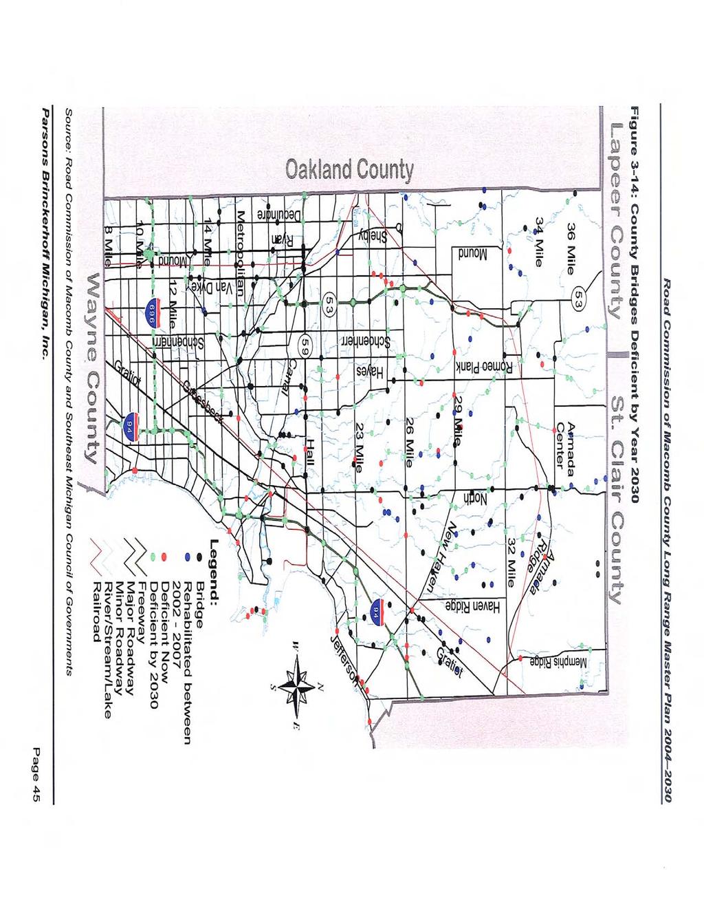
50
51 The bridge would reach age 50 by 2030, or The bridge is currently structurally deficient or functionally obsolete The age criterion allows SEMCOG to be able to make predictions for when bridges that are not currently deficient might become deficient. Local officials reviewed SEMCOG s analysis and agreed that 50 years was a reasonable life span for a bridge, and that it would be a reasonable assumption that a bridge would need repair or replacement once it reaches 50 years. SEMCOG s bridge sufficiency ratings indicate that 78 of the Macomb County s 230 bridges are deficient structurally, and that 26 of those 78 bridges are functionally obsolete (Status of Bridges in Southeast Michigan, SEMCOG: April 2002). Structural adequacy or deficiency is related to a bridge s ability to carry a given weight or load. Functional adequacy or deficiency is related to a bridge s width or vertical clearance over the stream, railroad, or other highway being crossed. For structural or functional purposes, 78 bridges in Macomb County will need to be replaced Non-Motorized As the northern portion of the County develops, farmlands are being converted into residential neighborhoods and homeowners are looking for larger, country lots. These country estate lots limit opportunities to acquire land for park and recreation needs, whereas higher density residential developments provide the opportunity to provide more open space areas. This section of the report contains a summary of major non-motorized pathway improvements, including planned bicycle and pedestrian pathways. The improvements described in this section are contained in the Partners in Planning report and master plans submitted by local communities in Macomb County. They are also part of the geographic information systems (GIS) data provided by Macomb County Planning. Macomb County Greenway Vision Greenways A Vision for Southeast Michigan is a plan developed by the Rails to Trails Conservancy, in partnership with the National Park Service Rivers, Trails and Conservation Assistance Program. This plan hopes to create an interconnected greenway system for the southeastern Michigan seven county region. Macomb County supported this vision in a letter received in July This plan would use river and stream corridors, lake shorelines, existing road and utility corridors, and abandoned railroad beds for the development of linear parkways to link existing parks and open spaces. These linear parkways would provide trails for bicycles and pedestrians. The Macomb County Michigan 1977 Comprehensive Recreation and Open Space Master Plan established broad goals and policies for the development of parks and open spaces. This plan mirrored a great portion of the Greenways Vision. The Macomb County Bikeway is a joint effort between the Huron-Clinton Metropolitan Authority and local communities. It is being developed as part of the greenway system in the central part of the County. The system includes river corridors along the Clinton River and its tributaries, large and small parks, road corridors, and potentially utility and rails-with-trails corridors. 4 4 Partners in Planning, Macomb County, Michigan, Final Report, Partners in Planning; March 2000 Page 46
52 Washington Township Washington Township has established the goal of providing non-motorized pathways throughout the Township to accommodate recreation activities such as walking, biking and jogging and provide safe and effective access from neighborhoods to parks. Washington Township is part of the Macomb Orchard Trail initiative. A section of this trail will be located along the Grand Trunk Western Railroad Corridor. This trail will connect Romeo and Washington and tie into the existing 26 Mile Road trail. When completed, the Macomb Orchard Trail will provide access to the Stony Creek Metropark Trail. The portion of the Macomb Orchard Trail located within Washington Township has been almost completed in its entirety. There are two sections of this trail still to be completed. One of these sections is located on 26 Mile Road and Mound Road and is currently being planned and designed. The second incomplete section is located along the TRW Technology Park and will ultimately connect with the Metro Park Trail. The Village Plan Recommendations contained in the Washington Township Master Plan include three areas of focus for Non-Motorized Pathways and overall Pedestrian Circulation as described below: Pedestrian Circulation: In order to provide adequate pedestrian walkways that link Washington Township neighborhoods to the Village area, two alternatives are being explored. The first alternative involves establishing the 26 Mile Road Pathway that runs from Stony Creek Metropark to the M-53 bypass as a way of reaching the Village. The second alternative is the Macomb Orchard Trail (MOT) which was previously explained in this report. Intersection Design: The provision of traffic calming materials (e.g. textured roadway surfaces) at key intersections of the Village area such as Van Dyke Avenue and West Road and Van Dyke Avenue and 27 Mile Road should help facilitate pedestrian circulation in the Village. Cross Section: Although the widths of the streets in the Village area are not proposed to be reduced, major roadways within the Village are proposed to be only 27-feet wide. In addition, Washington Township intends to work with the Macomb County Road Commission to review speed limits to allow a safe pedestrian environment in the Village area. City of Richmond The City of Richmond s master plan states that it is necessary to encourage the development of a pedestrian and bicycle path system to link residential neighborhoods and existing recreational facilities within the City. The City of Richmond operates three recreational facilities that include Beebe Street Memorial Park, Bailey Park, and Gierk Park. In addition, the City of Richmond is part of the Macomb Orchard Trail initiatives; and sections of this trail will cross the City of Richmond. Harrison Township Harrison Township, in cooperation with the Huron-Clinton Metropolitan Authority (HCMA), Macomb County, and other local governments, has undertaken the task of developing a regional bicycle/pedestrian path linking the County s existing recreation resources. A section of this pathway has been already developed and is located along Metropolitan Parkway from the entrance of Metro Beach Metropark to I-94. Page 47

53 The proposed bicycle/pedestrian path along Metropolitan Parkway is currently being continued towards the west portion of Freedom Hill Park, and will then turn north to the Clinton River to run along the river valley. The proposed pathways will transverse the Rochester-Utica recreation area located north of Stony Creek Metropark and extend to Wolcott Mill Metropark along 26 Mile Road, east of the future Wetzel State Park. Future sections of this path will include connections through the original locations of old paths such as along Romeo Plank Road and other roads through Mt. Clemens. Lenox Township Lenox Township has developed a non-motorized pedestrian path concept that comprises two bike paths. These bike paths will run along Gratiot Avenue and connect the Township to adjacent communities. The first bike path will connect New Haven s Wetzel State Park to the Lenox Township Park. The second bike path will link the City of Richmond to the Lenox Township Park. These bike paths are illustrated in Figure Figure 3-15: Lenox Township Pedestrian Path Concept Page 48
54 Macomb County Planning Non-Motorized Plan Figure 3-16 illustrates the Macomb County Planning department existing non-motorized plan Transit The Surburban Mobility Authority for Regional Transportation (SMART) provides transit services for Macomb County and the southeast Michigan area. SMART provides fixed route line-haul service, connector services, and community transit. Their fleet consists of 29-foot, 35-foot, and 40-foot large buses and also 21-foot and 24-foot small buses. Figure 3-17 illustrates the fixed route line-haul bus service in Macomb County. There are currently 16 fixed route line-haul bus routes in Macomb County, which serve 14 out of the 26 communities in Macomb County. None of the current SMART bus service goes north of 23 Mile Road. Table 3-14 summarizes the Community Transit that is available within Macomb County. Table 3-14: Community Transit Community Service Provider Armada Township, Armada Village, Chesterfield Richmond Lenox EMS Township, Lenox Township, City of Memphis, New Haven, Ray Township, City of Richmond, Richmond Township Bruce Township, City of Romeo, and Washington Township Star Transportation Center Line and Warren City of Warren Parks and Recreation Department Clinton Township Clinton Township Senior Adult Life Center Eastpointe City of Eastpointe Fraser City of Fraser Harrison Township Harrison Township Dial-a-Ride Macomb Township Macomb Township Mount Clemens Mount Clemens Community Transportation Roseville City of Roseville Parks and Recreation Shelby Township and City of Utica Charter Township of Shelby St. Clair Shores City of St. Clair Shores/Parks & Recreation/Senior Activities Center Sterling Heights City of Sterling Heights Source: Suburban Mobility Authority for Regional Transportation (SMART) Connector services are also available for all of the above communities as well. The one community that does not have community transit is the city of New Baltimore. Page 49
55

56
57 3.3.9 Overview of Community Plans Transportation s This section summarizes planned transportation improvements for communities located within Macomb County. The improvements described in this section were originally encompassed in local master plans and have been summarized to provide a general overview of local initiatives that should be evaluated as part of the Macomb County Road Commission Long Range Transportation Master Plan. This information is intended to complement Macomb County Road Commission plans and provide an overview of local issues and requirements. The summary presented herein is presented both in a narrative form and graphically described on a map. Proposed transportation improvements have been labeled within the text and noted in Figure The Master Plans discussed in this section are referenced in Table Table 3-15: Community Master Plans and Adoption Dates Community Name of Document Date Adopted Washington Township Comprehensive Master Plan (Draft) Approved for Distribution February 19, 2003 Prior Plan approved on April 8, 1993 (N/A) City of Richmond Master Plan December 12, 2002 Charter Township of Harrison Master Plan 2010 May 28, 1992 Lenox Township April 21, 1997 Richmond Township Lenox Township Master Plan April 9, 2002 Armada Township Ray Township Charter Township of Chesterfield Armada Township Master Plan Ray Township Master Plan Charter Township of Chesterfield Master Plan 2002 Not been adopted yet. No tentative date of adoption scheduled. November 21, 1991 New Master Plan in the process of adoption Public Hearing scheduled for March December 10, 2002 Bruce Township Bruce Township Master Plan April 26, 2000 Charter Township of Shelby Master Plan Macomb Township Macomb Township Master Plan 2002 City of New Baltimore City of New Baltimore Master Plan 2010 Source: Langworthy Strader LeBlanc & Associates, Inc. June, 1993 New Plan recently adopted available online but not reviewed. December 23, 2002 June 21, 1994 Page 52
58
59 Washington Township Washington Township has included planned transportation improvements in three main sections of their Master Plan: the Strategies Section, the Transportation Plan, and the Village Plan. Washington Township plans to provide efficient vehicular traffic and an overall Level of Service C or greater on all roadways located within the Township. As part of its strategies, Washington Township has established the need to work with Macomb County and State Agencies in the following initiatives: Require acceleration/deceleration/by-pass lanes where such lanes will provide a benefit to the community. Install directional signs in important districts in the area. Provide input during the redesign process of 26 Mile Road to locate a crossing bridge over M-53. This proposed improvement is labeled (1) on Figure Create traffic and access standards to improve safety on roadways in Washington Township. Improve safety on roadways through better location, alignment, and spacing of access and marginal access roads. Locate marginal access roads along M-53 between 29 Mile Road and 32 Mile Road. Balance the needs for onsite circulation, access, and emergency services with the inherent conflict of offsite traffic safety flow. A series of improvements along major roads within Washington Township have been proposed as part of their Master Plan. The summary presented herein categorizes proposed improvements in three sections: freeway access, Van Dyke Avenue, and collector roads. These improvements are described in the following paragraphs. Freeway Access: Several interchanges and highway improvements have been proposed along M-53 to improve overall northbound and southbound circulation and provide adequate access to this major thoroughfare, which include: Construct two additional travel lanes to the east of the existing road surface along M-53. This improvement is labeled (2) on Figure Provide an interchange at the intersection of M-53 and 32 Mile Road. This improvement is labeled (3) on Figure Provide a grade-separated crossing at the intersection of M-53 and 28 Mile Road. This improvement is labeled (4) on Figure Provide a grade-separated crossing at the intersection of M-53 and 31 Mile Road. This improvement is labeled (5) on Figure Provide an at-grade crossing at the intersection of M-53 and 30 Mile Road. This improvement is labeled (6) on Figure Van Dyke Road: Washington Township and the Road Commission of Macomb County plan to re-design Van Dyke Road in the Washington Village area. The proposed improvement consists of the reduction of Van Dyke to a three (3) lane road with on-street parking. The Township wants to work with the Road Commission of Macomb County to develop a downtown atmosphere that fits both uses of the roadway. This improvement is labeled (7) on the attached map. Collector Roads: Washington Township has established the need to modify the existing collector road system to provide access to the interior acreage bounded by section line roads. These roads are intended to be 86-feet wide and follow quarter section lines. The Washington Page 54
60 Township Village Area Plan promotes implementing a grid pattern within the village. In addition, the plan enhances increased street connections to provide better circulation through the village. City of Richmond The City of Richmond has established, as part of their master plan, a set of goals to ensure adequate traffic circulation throughout the City s road system and improve circulation along the Main Street and Gratiot Avenue corridors. These goals include: Continuously update the Master Thoroughfare Plan and effectively implement the recommendations comprised in each update. Traffic counts and intersection studies will be performed regularly to maintain an updated database of existing traffic conditions. Continue working with the Michigan Department of Transportation to investigate traffic calming devices and signalization to minimize vehicular impacts along Main Street and Gratiot Avenue. Alternative road patterns will be analyzed and implemented in order to provide better circulation throughout the City. Ensure that adequate emergency vehicle access is provided, especially at the two Grand Trunk railroad crossings. The number of access drives within all areas of the City will be limited as part of the master plan initiative to provide solutions for access management issues. Charter Township of Harrison In order to support land use changes, the Charter Township of Harrison established in its Thoroughfare Plan a set of major transportation improvements. The proposed improvements have been categorized in four sections that include: freeway connections, major roads, collector streets, and local roads. These four sections are summarized in the following paragraphs. Freeway Connections: I-94 and M-59 pass through Harrison Township. Recent development patterns in the Township have increased the need for improved freeway connections. In order to better serve its population, Harrison Township has identified intersections that require improvements: Implement a full service interchange at Shook Road and I-94. Interstate-94 runs along the eastern boundary of Harrison Township, and the recent increase in multiple-family development located around I-94 has increased the demand for better freeway connections. Redesign the I-94 and North River Road interchange. Local Roads: Existing local road roadways are aligned in a grid pattern, which permits traffic to cut through residential neighborhoods. The Thoroughfare Plan envisions the future development of local roads to consist of curved local streets, cul-de-sacs, and turnarounds. Lenox Township Lenox Township roads are generally aligned in a grid pattern. Major roads traversing the Township include 26 Mile Road, 27 Mile Road, Place Road, Haven Ridge Road, County Line Road, New Haven Road, and Gratiot Avenue. The Lenox Township Thoroughfare Plan contains a series of recommendations to improve the overall traffic circulation system within the Township. s are described in the following paragraphs. Page 55
61 Planned Right-of-Way: The Township has established typical planned right-of-way for the different roadways within the Township. They include: Interstate-94 is planned to maintain a freeway right-of-way. Gratiot Avenue (M-19) is planned to have a regional highway right-of-way of 150-feet. 26 Mile Road is planned to have a right-of-way of 204-feet. Major thoroughfares including 32 Mile Road, 29 Mile Road, County Line Road, New Haven Road, and Haven Ridge Road are planned to have a right-of-way of 120-feet. Secondary thoroughfares that include 27 Mile to 31 Mile Roads, Place Road, Werderman Road, Bates Road, Lowe Plank Road, Forest Road, and Rosell Road are planned to have a right-of-way of 120-feet. Omo Road is proposed to be a scenic beauty thoroughfare and have a right-of-way of 120- feet. Collector roads including Frost Road, Kuster Road, Pashalk Road, and Gramer Road are planned to have a right-of-way of 86-feet. Conceptual Collector Roads: A number of conceptual collector roads have been included as part of the Thoroughfare Plan. These collector streets should help alleviate additional traffic generated by increased development along Gratiot Avenue. The proposed collector roads include: A north-south collector is proposed between 26 Mile and 27 Mile Roads to respond to new and future residential and commercial development located between Frost Road, New Haven Road, Gratiot Avenue, and 26 Mile Road. This improvement is labeled (8) on Figure A north-south collector is proposed between 27 Mile and 28 Mile Roads. Similar to the improvement described above, the Mile Road collector should help alleviate traffic along Gratiot Avenue. This improvement is labeled (9) on Figure An east-west collector is proposed between Gratiot Avenue and Frost Road. The proposed collector will provide access from Gratiot Avenue to residential areas located east of Gratiot Avenue. This improvement is labeled (10) on Figure A circle collector is proposed on 28 Mile Road. The circle collector will allow area users to circumvolve through 1.5 miles of mixed land uses. This improvement is labeled (11) on Figure Richmond Township The Richmond Township Thoroughfare Plan identifies a series of transportation improvements considered necessary to support recent and future development. The proposed improvements can be categorized in four sections: major thoroughfares, industrial collectors, local roads, and local road design standards. The proposed improvements are described in the following paragraphs. Major Thoroughfares: Richmond Township contains six main roads designated as major thoroughfares; they include: Omo Road, Armada Ridge Road, Memphis Road (M-19), School Section Road, 32 Mile Road, and Boardman Road. s are planned for the following roadways: Stood Road is proposed to be developed from 32 Mile Road, or Division Street, to Pound Road, with a right-of-way of 120-feet. This improvement is labeled (12) on Figure The Township believes M-19 should be the only major thoroughfare to be expanded beyond the 120-foot right-of-way. Page 56
62 Industrial Collectors: In order to better serve industrial development occurring in Richmond Township the following industrial collectors have been planned: An industrial collector road is proposed to be developed from 32 Mile Road to the extension of Madison Road. This improvement is labeled (13) on Figure A second option for an industrial collector road has been envisioned to link 32 Mile Road and the extension of Madison Road. This industrial collector would follow the diagonal alignment of the existing railroad tracks and is located west of the Township boundary. This improvement is labeled (14) on Figure Madison Road could link the proposed collector roads (east-west) to Stoddard Road. Madison Road would potentially constitute the third industrial collector and would need to be upgraded to adequately accommodate industrial traffic. Local Roads: Richmond Township does not have any plans to change the local roadways. Low density areas are envisioned north of Armada Ridge Road and west of M-19, which should limit the need for improvements on the local roadways. Local Road Design Standards: In order to adequately support neighborhood activities and provide a more pleasant environment, Richmond Township has established the following three design guidelines: The width of the street should be based on the volume of traffic anticipated. The design should anticipate the need and/or desire for curb and/or off-street parking. All streets should be designed and constructed to meet accepted engineering standards and safely control traffic. Short residential streets that create unique neighborhoods should discourage through-traffic. Armada Township Armada Township has developed a Thoroughfare Plan to provide adequate roads to serve future population needs and support land use change. The Thoroughfare Plan proposed one transportation improvement: the extension of Capac Road from Armada Center Road to south of 33 Mile Road. This improvement is labeled (15) on Figure Ray Township Roadway improvements have been proposed in the Ray Township Thoroughfare Plan in order to serve the land use pattern envisioned for the Township. No new roads have been proposed as part of this plan. All major roads such as Romeo Plank Road, New Haven Road, North Avenue, 29 Mile Road, and 32 Mile Road will continue to have a planned right-of-way width of 120-feet. However, 26 Mile Road, which is considered a major road is planned to have a rightof-way width of 204-feet. The Township secondary roads are planned to have a right-of-way width of 86-feet. Local subdivision roads are planned to have a right-of-way width of 60-feet. Charter Township of Chesterfield Charter Township of Chesterfield has developed the following set of recommended improvements based on existing road conditions, recent development patterns, future land use patterns, and current traffic volumes: In order to improve traffic circulation caused by numerous access drive interruptions on 23 Mile Road, marginal access service roads are recommended on the north and south side of 23 Mile Road. Page 57
63 A connection is proposed from Callens Road to Baker Road, at the intersection of 23 Mile Road. This improvement is labeled (16) on Figure A network of collector streets with planned right-of-way widths of 86-feet have been added to assist in reducing future traffic problems on major roads. This improvement is labeled (17) on Figure An overpass is proposed at the intersection of I-94 and 24 Mile Road. This improvement is labeled (18) on Figure Bruce Township In an effort to alleviate traffic congestion within Bruce Township the following improvements have been included as part of their Master Plan: An extension of M-53 has been proposed from the Township boundary to the Village of Romeo, south of 34 Mile Road. This improvement is labeled (19) on Figure A collector road has been proposed from 37 Mile Road at its intersection with Hipp Road to 36 Mile Road. This improvement is labeled (20) on Figure A series of scenic routes have been proposed which include: McKail Road, Wales Road, Eldred Road, Lassier Road, and 33 Mile Road. Charter Township of Shelby In order to provide roadway improvements that will ease existing traffic congestion, a consequence of increased development, and be able to support additional pressure on the existing roadway network that may occur as a result of future land use patterns, the Charter Township of Shelby developed a series of proposed improvements for its road network. The improvements are contained in its Thoroughfare Plan and are summarized in the following paragraphs. Van Dyke Avenue: In order to improve circulation along M-53 and accommodate short distance traffic, a series of marginal access service drives are recommended on the east side of M-53, north and south of 23 Mile Road. Collector Roads: For roads located near the quarter section lines, an 86-foot wide right-of-way has been planned. Shelby Road: A new access to River Bends Park is proposed from Woodall Road to relieve Shelby Road s traffic north of 22 Mile Road. Auburn Road: Parking areas located along Auburn Road should be interconnected to minimize the number of driveways along this road. Macomb Township Macomb Township s master plan provides a planned right-of-way and functional classification for streets and highways based on anticipated land uses. The right-of-way widths identified for the different types of roadways are described in the following paragraphs. Major Roads: The proposed right-of-way width for M-59 is 350-feet. The planned right-of-way width for 26 Mile Road is 204-feet. North Avenue is planned to have a right-of-way width of Page 58
64 150-feet. Other major roads in Macomb Township are planned to have a right-of-way width of 120-feet. Collector Roads: All collector roads within the Township are planned to have a right-of-way width of 86-feet. Industrial Roads: Industrial roads will have a right-of-way width of 70-feet. Local Roads: Connector roads are planned to have a right-of way width of 60-feet. City of New Baltimore The City of New Baltimore has established goals for providing a safe and efficient network of streets and roads in order to better serve the existing and future population, and support land use development patterns. Traffic conditions for their roadway network are described in the following paragraphs. Major Streets: The City s major streets include 23 Mile Road (M-29), Washington Street, County Line Road, and Jefferson Avenue. These routes lack adequate capacity. A 120-foot right-ofway width is planned for major streets within the City. Local Streets: Existing local streets within the City of New Baltimore have varying conditions and in some cases do not meet engineering and design standards. Local streets should be planned to discourage through-traffic and facilitate access to existing and proposed developments within the City. 3.4 Public Involvement In preparation of creating a Long Range Transportation Master Plan, the Road Commission of Macomb County held a Public Meeting for Macomb County residents to share their ideas and opinions regarding transportation issues in Macomb County. The public meeting was held on Wednesday, October 29, 2003 at the following times and locations: 3:00-5:00 PM: Road Commission Building 7:00-9:00 PM: Macomb Township Hall Representatives of the Road Commission and its consultants were available to discuss the process, data, and goals of the study, as well as any ideas the public may have. A total of approximately 60 people attended both meetings. In addition to collecting public input at these meetings, input from the public could also be sent via to the Road Commission of Macomb County at macombplan@pbworld.com. A summary of the public responses can be found in Appendix A of this report. 3.5 Existing Conditions Summary Macomb County has one of the fastest growing townships in Michigan (Macomb Township) and is one of the fastest growing counties in terms of population and employment in Michigan. Due to land development patterns within Macomb County, the southern half of the county has different transportation needs than the northern half. Since the northern half of the county is growing at such a rapid rate, new transportation facilities are needed compared to the southern Page 59
65 half of the county which is in need of maintenance and minor transportation facilities. A long range transportation master plan will assist in guiding the RCMC for the next 25 years due to the current and projected growth and development. Page 60
66 4.0 Future Conditions This chapter describes the future land use and the expected roadway conditions using the 2030 Southeast Michigan Council of Governments (SEMCOG) TRANPLAN model. 4.1 Future Land Use As stated in Chapter 2.0, Macomb County is situated north of the city of Detroit, along the western shore of Lake St. Clair and east of Oakland County, Michigan. Development of the county has historically been influenced by transportation corridors, waterways, and large developments located throughout the county. Historic community centers, such as Mt. Clemens and Utica, were established along the Clinton River and date back to 1795 and 1817, respectively. Over the years these older community centers have become surrounded by more modern suburban development moving northward from Detroit. Today, approximately 51-percent of Macomb County is developed. By the year 2030, 30- percent more of the land is expected to be developed. Figure 4-1 provides the future land use map. Compared to the existing land use, the following changes are expected to occur within Macomb County: The northern portion of Macomb County is anticipated to change from primarily cultivated, grassland, and shrub with scattered single-family residential to primarily agricultural/rural residential, with single-family housing ranging from 0.25 acres to 1.0 acres per dwelling unit. The middle portion of the County is anticipated to go from mixed uses (mainly single-family residential and cultivated, grassland, and shrub) to primarily low density residential. The southern portion of the County is anticipated to change from primarily single-family residential to medium to high density residential. Sterling Heights will continue to be primarily single-family residential with concentrations of industrial between Mound Road and Van Dyke Avenue. 4.2 Future 2030 Roadway Conditions This section describes the future 2030 roadway conditions using the Southeast Michigan Council of Governments (SEMCOG) travel demand forecasting model, called TRANPLAN. TRANPLAN belongs to a group of models collectively known as travel demand models. Travel demand models are macroscopic regional planning tools. The macroscopic models look at the big picture and do not contain detailed information, such as the local street system (residential streets). The freeways and arterial roadways are contained in these regional models. The TRANPLAN (TRANsportation PLANning) model was utilized to predict the future conditions for the project area. The SEMCOG model is a seven county regional model for southeast Michigan that includes Livingston, Macomb, Monroe, Oakland, St. Clair, Washtenaw, and Wayne counties. The model also takes into account trips made to Windsor, Ontario and Sarnia, Ontario and other outlying areas of the region. The future year model includes projects identified in SEMCOG s Transportation Program (TIP). The model also includes all major roadways in the region classified as collector or higher. Page 61
67 Figure 4-1: Macomb County Future Land Use Lapeer County St. Clair County Memphis Bruce Twp Armada Twp Richmond Twp Richmond Oakland County Washington Twp Center Line Shelby Twp Utica Sterling Heights Warren Ray Twp Macomb Twp Mount Clemens Fraser Clinton Twp Roseville Eastpointe Wayne County Source: Southeast Michigan Council of Governments St. Clair Shores Lenox Twp Chesterfield Twp Harrison Twp New Baltimore Legend Agricultural/Rural Residential Commercial Commercial/Mixed Use Industrial Institutional/Public/Quasi Public Low Density Residential Medium Density Residential High Density Residential Office Open Space/Conservation Planned Unit Development/Other Use Transportation/Communication/Utility Water Page 62
68 SEMCOG s 2025 TRANPLAN model was reviewed based on the future land use data and roadway improvement data collected to ensure the most current data is being utilized in the forecast model. At the time of this analysis the 2030 model was under development at SEMCOG. However, SEMCOG had adopted year 2030 development and socio-economic data. Although the 2030 model network had not yet been completed, the latest development information and socio-economic projections (year 2030) were incorporated into the year 2025 model base network in order to achieve the goal of providing a master plan with a future planning horizon of The base 2025/2030 TRANPLAN analysis results were utilized to identify future link level deficiencies. Future transportation improvements were tested based on identified needs and deficiencies. This section of the report reviews the travel demand forecasting results for the year 2030 No- Build and Build Conditions Future 2030 No-Build Roadway Conditions The 2025/2030 SEMCOG TRANPLAN model for the No-Build Condition assumed the roadways remain as they exist today. However, all other planned transportation improvements included in the SEMCOG Transportation Program (TIP) scheduled for completion by the year 2025/2030 have been incorporated into the model Figure 4-2 illustrates the expected daily future year 2030 roadway congestion if no changes were made to the existing roadway system (except for those improvements listed in SEMCOG s TIP). Figure 4-3 illustrates the expected PM peak hour future year 2030 roadway congestion if no changes were made to the existing roadway system (except for those improvements listed in SEMCOG s TIP). Figure 4-4 indicates that under the 2030 No-Build Conditions, approximately 33-percent of the roadways in Macomb County will be heavily congested during the PM peak hour, meaning that these roadways will be in stop-and-go conditions. Page 63
69
70
71 Figure 4-4: Future 2030 No-Build Congestion PM Peak Hour Little or No Congestion 51% Slight Congestion 8% Moderate Congestion 8% Heavy Congestion 33% Source: The following roadways that were heavily to severely congested in the daily and PM peak hour models are: Hall Road 23 Mile Road 26 Mile Road Mound Road Van Dyke Avenue Schoenherr Road M-53 Romeo Plank Road North Avenue 18 Mile Road TRANPLAN Roadway s Based on the existing deficiencies identified in Chapter 2.0 of this report, as well as the future 2030 No-Build Conditions results utilizing the 2025/2030 TRANPLAN model, roadway improvements were identified. Below is a list summarizing proposed roadway improvements analyzed using the SEMCOG TRANPLAN model. As indicated above, most of these improvements were determined by existing deficiencies as well as the future 2030 No-Build deficiencies. The SEMCOG model includes only collector roadways and higher so not all recommendations could be tested using the SEMCOG model. Therefore, the list below does not encompass all the recommendations for the county, please see Chapter 5 for a complete listing. Roadway Widenings: Add one lane of travel in each direction on Hall Road between M-53 and I-94, include acceleration and deceleration lanes for businesses Widen 18 Mile Road from Dequindre Road to Utica Road to five-lanes Widen 21 Mile Road between Van Dyke Avenue and North Avenue to five-lanes Page 66
72 Widen 23 Mile Road between M-53 and I-94 to five-lanes Widen 26 Mile Road from east of Van Dyke Avenue to east of M-53 to six-lanes Widen 26 Mile Road to a four-lane boulevard from east Shelby/Park ramps to west of the ramps Widen 26 Mile Road to a four-lane boulevard from west of North Avenue to Romeo Plank Road Widen 26 Mile Road to a four-lane boulevard from west of the I-94 western ramps to east of Werdeman Road Widen 26 Mile Road to a four-lane roadway from County Line Road to just west of the I-94 interchange Widen 26 Mile Road to a four-lane roadway from east of Werdeman Road to west of North Avenue Widen 26 Mile Road to a four-lane roadway from west of the Shelby/Park ramps to Dequindre Road Widen 26 Mile Road to a six-lane boulevard from east of Jewell Road to east of the M-53 interchange Widen 26 Mile Road to a six-lane boulevard from east of Van Dyke Avenue to east Shelby/Park ramps Widen 26 Mile Road to four-lane boulevard from Romeo Plank Road to east of Jewell Road Widen 32 Mile Road between Old Van Dyke to Armada Ridge to five-lanes Widen Gratiot Avenue from 26 Mile Road to County Line Road to five-lanes Widen Haven Ridge from Clark/27 Mile Road to New Haven Road to five-lanes Widen M-53 from 18 Mile Road to 23 Mile Road from four-lane freeway to six-lane freeway Widen M-53 from 23 Mile Road to 26 Mile Road from four-lane freeway to six-lane freeway Widen Mound Road from six-lane boulevard to eight-lane boulevard from 17 Mile Road to M-59 Widen New Haven Road from Haven Ridge to I-94 to five-lanes Widen North Avenue from 23 Mile Road to 26 Mile Road to five-lanes Widen North Avenue from Hall Road to 23 Mile Road to five-lanes Widen Romeo Plank Road from 23 Mile Road to 26 Mile Road to five-lanes Widen Romeo Plank Road from 26 Mile Road to 32 Mile Road to five-lanes Widen Romeo Plank Road from Cass Avenue to 23 Mile Road to five-lanes Widen Sugarbush Road from 23 Mile Road to 21 Mile Road to five-lanes Widen Utica Road from Van Dyke Avenue to Hayes Road to five-lanes Widen Van Dyke Avenue between 28 Mile Road and 32 Mile Road to five-lanes Widen Washington Street from I-94 to Main Street (New Baltimore) to five-lanes Roadway Connections / Extensions / Construction: Connect 24 Mile Road over I-94 Connect Hipp Road from 36 Mile Road to 37 Mile Road Connect 18 Mile Road from Utica Road to Hayes Road as five-lanes Extend Capac Road from Armada Center Road to south of 33 Mile Road as two-lanes Extend Garfield between 21 Mile Road to 25 Mile Road Extend Hayes between Groesbeck Highway and Martin Road Realign Romeo Plank at 25 Mile Road Roadway Paving: Pave 29 Mile Road from New Haven Road to Gratiot Avenue and raise functional classification to collector Page 67
73 Pave 34 Mile Road between Dequindre Road and McKay Road and raise functional classification to minor arterial These roadway improvements were incorporated into the TRANPLAN model. The results are provided in Section 4.2.3, Future 2030 Build Condition Future 2030 Build Condition The roadway improvements identified in Section were incorporated into the future year 2030 Build Condition TRANPLAN network. Figure 4-5 illustrates the expected daily future year 2030 roadway congestion for the Build Condition. Figure 4-6 illustrates the expected PM peak hour future year 2030 roadway congestion for the Build Condition. Page 68
74
75
76 Figure 4-7 indicates that under the 2030 Build Conditions, approximately 23-percent of the roadways in Macomb County will be heavily congested during the PM peak hour, meaning that these roadways will be in stop-and-go conditions. This is a 10-percent reduction in heavy congestion during the PM peak hour when compared to the No-Build Conditions. Figure 4-7: Future 2030 Build Congestion PM Peak Hour Little or No Congestion 61% Slight Congestion 8% Moderate Congestion 8% Heavy Congestion 23% Source: 4.3 Future Conditions Summary Utilizing the 2030 land use and roadway data in the SEMCOG TRANPLAN model, an analysis was run for the future 2030 No Build Condition and the 2030 Build Condition. The existing SEMCOG TIP has identified projects for Macomb County that will alleviate some congestion, but based on the SEMCOG TRANPLAN model congestion levels will still exist. A number of roadway improvements were tested to assess whether the additional improvements would continue to reduce traffic congestion. A list of roadway widenings, extensions, and pavings were tested to assess the 2030 future roadway needs. These additional roadway improvements would reduce the heavy congestion by 10-percent, and provide more roads with little or no congestion by 10-percent. The recommendations for improvements in Macomb County are listed in Chapter 5. Page 71
77 5.0 Short-Term, Mid-Term, and Long-Term Recommendations This section provides the short-term, mid-term, and long-term recommendations for the Macomb County Long Range Master Plan up to the year The short-term, mid-term, and long-term recommendations were determined using a variety of information, including the following: Previous Road Commission of Macomb County Master Plan City and Township Master Plans Michigan Department of Transportation Pavement Information SEMCOG Intersection Crash Information SEMCOG Future Land Use Information Bridge information from SEMCOG and the Road Commission of Macomb County Existing Roadway Congestion Future 2030 Roadway Congestion Comments received from the Public Meeting as well as through mail, , and fax The recommendations are clustered in three different time frames: short-term, mid-term, and long-term. The short-term recommendations are those projects that should occur between 2004 and The mid-term recommendations are those projects that should occur between 2010 and 2020 and the long-term recommendations are those projects that should occur between 2020 and The time frame for the recommendations was completed by balancing existing needs and deficiencies to future needs and deficiencies. For example, if a roadway is currently listed as moderately congested today but in the year 2030 it is listed as severely congested, then that roadway widening would be placed in the long-term recommendations. However, if a bridge located along that roadway was listed as critical in the mid-term recommendations, then the roadway widening was moved into the mid-term recommendations. As part of the Long Range Master Plan recommendations, several additional studies are recommended. These additional studies are based on requests from the public, city commissioners, and/or local agencies from the October 2003 public meetings and are not included in the cost estimate provided in Section 5.4 of this report. It is highly recommended that coordination with the Macomb County Planning Department should occur regarding mobility (transit) and non-motorized issues, as the Long Range Master Plan does not focus on these items. An Intelligent Transportation System (ITS) Master Plan document is expected to be completed in the Spring of This ITS Master Plan document should address all ITS issues within Macomb County. While this Long Range Plan recommends some elements of ITS in Macomb County, it is expected that the ITS Master Plan will review some of these recommendations and build upon them. The roadway improvements listed in the SEMCOG TIP are included under the short-term recommendations; however, they are not included in the cost estimate provided in Section 5.4 of this report. Page 72
78 During the review of recommendations, it was found that some roadways were recommended to be widened while the bridges on those roadways were not expected to be critical during that same timeframe. In some cases, some bridges are recommended to be rehabilitated under the mid-term recommendations even though the bridge is not expected to become critical during this timeframe. Therefore, these bridges are included under the mid-term recommendations because they either pass over or under roadways expected to be widened or rehabilitated between the years 2008 to The following sections summarize the short-term, mid-term, and long-term recommendations for the Road Commission of Macomb County Long Range Master Plan. Figures 5-1 through 5-3 provide a graphical representation of the short-term, mid-term, and long-term recommendations, respectively. 5.1 Short-Term Recommendations ( ) Short-term recommendations are anticipated to occur within the next six years. Figure 5-1 illustrates these recommendations on a county-wide map. County Wide: The first set of recommendations are county-wide recommendations that include broad-range plans and standards for the county. These recommendations were a result of many comments made by local municipalities and trends being made by other counties in the state of Michigan as well as throughout the nation. Develop an Access Management Plan for Macomb County (see section for more information) Review residential street design and construction standards (see section for more information) Develop/review standards for pedestrian improvements and access in roadway design Develop standardized procedures for traffic impact studies that all local communities would abide by (see section for more information) Review County formula for funding roadway improvements Conduct coordination meetings between RCMC and local communities Conduct signal warrant studies as roadways are widened Install new street signs and upgrade older street signs throughout Macomb County Bridges: Most County Road Commissions have money in their budget to rehabilitate and rebuild bridges within their county. The Road Commission of Macomb County currently has a list of deficient bridges that are in need of rehabilitation. Those bridges are included in the list of bridges that need to be rehabilitated or rebuilt in short-term. A list of the bridges recommended to be rehabilitated or rebuilt is located in Appendix B. Paving: Through the public meeting and public comments received from local communities, the following roadways are recommended for paving in the short-term: Pave 34 Mile Road between Dequindre Road and McKay Road and raise the functional classification to minor arterial Pave Luchtman Road from 25 Mile Road to 26 Mile Road Roadway Widening: The following roadways are recommended for widening in the next five years based on existing congestion levels as well as comments received from the public and local communities. Widen North Avenue from Hall Road to 23 Mile Road to five-lanes (raise classification to minor arterial) Page 73
79 Widen Romeo Plank Road from Cass Avenue to 23 Mile Road to five-lanes (raise classification to major arterial) Widen 23 Mile Road between Hayes and I-94 to five-lanes (raise classification to major arterial) Widen Utica Road from Van Dyke Avenue to Hayes Road to five-lanes (keep four-lane pavement between 18 Mile Road and Dodge Park) Widen 26 Mile Road from Van Dyke Avenue to east of M-53 to six-lanes Roadway Connections / Extensions / Construction: Two roadways are recommended for extensions based on the existing SEMCOG Regional Transportation Plan as well as comments received from the public and local communities. These two roadway extensions already have the land set aside for the roadway and do not have any negative impacts on the environment. Extend Hayes between Groesbeck Highway and Martin Road Extend Garfield Road between 21 Mile Road to 22 Mile Road Extend 25 Mile Road between New Haven Road and Baker Road Operational Recommendations: These recommendations may improve the flow and safety of traffic and pedestrians and are operational in nature. Conduct ITS signal timing optimizations along the following three corridors: Metropolitan Parkway between Dequindre Road and Gratiot Avenue; Cass Avenue between downtown Mount Clemens and Romeo Plank Road; and Mound Road from 16 Mile Road to I-696. The ITS signal implementation will increase the capacity on these roadways. Update pedestrian clearance intervals at signalized intersections along 9 Mile Road, Gratiot Avenue, and Van Dyke Avenue Reconstruct / Rehabilitate Pavement: The following roadways are recommended to be reconstructed or rehabilitated based on existing roadway conditions. These roadways were listed as either poor to failed, according to the Michigan Department of Safety Pavement Sufficiency information. In addition, some roadways were added based on public comments received as well as MDOT pavement information. Little Road from Dunham Road to north of Dunham Road Hayes Road between 12 Mile Road and Common Road Quinn Road between Gratiot Avenue and I-94 Jefferson Avenue from 21 Mile Road to Dock Road Hayes Road between Martin Road and 12 Mile Road Intersection Studies: The following intersections are recommended to be reviewed and/or studied based on agency and public comments. The comments received from the public were general and included only the intersection name and perhaps a type of study, but did not indicate the reason for the request. The Road Commission of Macomb County continually receives requests from the public and local agencies to review intersections and responds to those requests promptly. As a result of these requests, the Road Commission will review these intersections to determine if changes are necessary. 32 Mile Road and Mound Road 32 Mile Road and Fisher Road Ebeling Road and Van Dyke Avenue Signal warrant analysis at Cotton Road and Sugarbush Road Signal warrant analysis at Callens Road and Sugarbush Road Jefferson Avenue and South River Road Jefferson Avenue and Metropolitan Beach Highway Page 74
80 Metropolitan Beach Highway and Crocker Street Jefferson Avenue and Crocker Street Romeo Plank Road and 26 Mile Road Geometric studies at Washington Road intersections within New Baltimore 24 Mile Road and Washington Road 25 Mile Road and County Line Road Romeo Plank Road at 29 Mile Road Geometric study at 26 Mile Road and new school, east of M-53 Auburn Road and Dequindre Road 26 Mile Road and Mound Road Geometric study at Utica Road and Dequindre Road Signal study at Clinton River Road and Schoenherr Road Signal study at 19 Mile Road and Michigan Road 19 Mile Road and Hayes Road Hayes Road and Canal Road Michigan Department of Transportation Coordination Issues: The following projects include those roadways and intersections that are under the jurisdiction of the Michigan Department of Transportation. Conduct intersection study at 34 Mile Road and Van Dyke Avenue. Install new exit signs along I-94 at 23 Mile Road. The signs should state 23 Mile Road exit instead of, or in addition to, the New Baltimore exit. Conduct ITS signal timing optimizations along the following three corridors: Van Dyke Avenue between I-696 and M-53; Gratiot Avenue between Eight Mile Road and Metropolitan Parkway; and Groesbeck between 14 Mile and Cass Avenue. Add one (1) lane of travel in each direction on Hall Road between M-53 and I-94; include acceleration and deceleration lanes for businesses. Items already included in SEMCOG Transportation Program (TIP): The following projects are those that are already included in the SEMCOG TIP and therefore already have some level of funding associated with them. Some of these projects may have already been completed or are in the process of being completed. Resurface / Reconstruct: Resurface 13 Mile Road between Gratiot Avenue to Little Mack (Roseville) Resurface 21 Mile Road between Gratiot Avenue and Jefferson Avenue Resurface 9 Mile Road from Gratiot Avenue to Tuscany Road (Eastpointe) Resurface Greater Mack Avenue from 8 Mile Road to 9 Mile Road (St. Clair Shores) Resurface Little Mack between Erin Road and Masonic Boulevard (Roseville) Resurface Masonic Boulevard between Kelly Road and Gratiot Avenue (Roseville) Resurface Masonic Boulevard between Little Mack to east Roseville City Limits (Roseville) Reconstruct Jefferson Avenue between 10 Mile Road and Riovista Road (St. Clair Shores) Reconstruct Jefferson Avenue between 9 Mile Road and Marter Road (St. Clair Shores) Reconstruct Masonic Boulevard from Hayes Road to Utica Road (Fraser) Extensions / Connections / Construction Construct 18 ½ Mile Road ramps to M-53 Extend 18 Mile Road from east of Garfield Road to Canal Road Extend 18 Mile Road from Canal Road to Cass Avenue Roadway Widenings Widen 13 Mile Road from Hoover Road to Hayes Road from four- to five-lanes (Warren) Page 75
81 Widen Gratiot Avenue from 24 Mile Road to 25 Mile Road from two- to five-lanes Widen Hayes Road from Hall to 21 ½ Mile Road from two- to five-lanes Widen Metropolitan Parkway from Garfield Road to Groesbeck Highway from four- to six-lane boulevard Widen Metropolitan Parkway from Utica Road to Garfield Road from four- to six-lane boulevard Widen 9 Mile Road from Hoover Road to eastern Warren City Limit to five-lanes (Warren) Replace / Rehabilitate Bridges: Replace 31 Mile Road over east branch of Coon Creek Rehabilitate McKay Road over north branch Clinton River Rehabilitate Romeo Plank Road over Gloede Drain Page 76
82
83 5.2 Mid-Term Recommendations ( ) The following mid-term recommendations are recommended to occur in the next six to 16 years. Figure 5-2 illustrates these recommendations on a county-wide map. Bridges: The following bridges are expected to be 50 years old by the year 2020 and will need to be reviewed by the Road Commission to determine if the bridges will need to be rebuilt, rehabilitated, or deferred for another five years. Please see Appendix B for a list of bridges expected to be deficient by the year Paving: The following roadways are recommended to be paved by the year These were based on public comments as well as land use changes in the northern half of the county that will necessitate the need for paved roadways. Pave 29 Mile from New Haven Road to Gratiot Avenue and raise the classification to collector Pave 24 Mile Road from Romeo Plank Road to Foss Road Pave 24 Mile Road from Card Road to North Avenue Pave 24 Mile Road from North Avenue to Fairchild Road Roadway Widening: The following roadways are recommended to be widened by the year These roadways have some degree of existing congestions and are expected to be severely congested by the year 2018 if the roadways are not widened. Widen North Avenue from 23 Mile Road to 26 Mile Road to five-lanes and raise classification to minor arterial Widen Romeo Plank Road from 23 Mile Road to 26 Mile Road to five-lanes and raise classification to major arterial; realign Romeo Plank Road at 25 Mile Road Widen Mound Road from six-lane boulevard to eight-lane boulevard from 17 Mile Road to M-59 Widen 21 Mile Road between Van Dyke Avenue and North Avenue to five-lanes, raise classification to minor arterial Widen 26 Mile Road to a four-lane roadway from County Line Road to just west of the I- 94 interchange; a four-lane boulevard from west of the I-94 western ramps to east of Werdeman Road; a four-lane roadway from east of Werdeman Road to west of North Avenue; a four-lane boulevard from Romeo Plank Road to east of Jewell Road; and a six-lane boulevard from east of Jewell Road to east of the M-53 interchange. Widen 18 Mile Road from Dequindre Road to Utica Road to five-lanes Widen Washington Street from I-94 to Main Street (New Baltimore) to five-lanes Roadway Connections / Extensions / Construction: The following roadways are recommended to be connected, extended, or constructed by the year Some of these roadways may need to have studies to determine if there are environmental impacts. Connect Broughton Road to Heydenreich Road between 22 Mile Road and 25 Mile Road as two- to three-lanes Extend/connect 18 Mile Road between Utica Road and Hayes Road as five-lanes Extend/connect 22 Mile Road between Card and Fairchild Extend/connect Luchtman Road between 24 Mile Road and 25 Mile Road as two-lanes. Reconstruct / Rehabilitate Pavement: The following roadways are recommended for reconstructing or rehabilitating the pavement surface. This is based on the Michigan Department of Transportation pavement rating of fair. While some of these roadways may not Page 78
84 need to be rehabilitated, or may need to be rehabilitated sooner, the Road Commission should review these roadways prior to Mile Road between Dequindre Road and Ryan Road (Warren) 9 Mile Road between Mound Road and Van Dyke Avenue (Warren) Stephens Road between Van Dyke Avenue and Hoover Road (Warren) 9 Mile Road between Hoover Road and Schoenherr Road (Warren) 9 Mile Road between Schoenherr Road and Hayes Road (Warren) 9 Mile Road between David Road and Kelly Road (Eastpointe) 12 Mile Road between Groesbeck Highway and I-94 Masonic Boulevard between Utica Road and Kelly Road (Fraser) Hayes Road between 14 Mile Road to south of 13 Mile Road Garfield Road between Utica Road and 15 Mile Road 14 Mile Road between Greater Mack Avenue to east of Kelly Road 15 Mile Road between Little Mack and Harper Avenue Rathbone Road between Dickinson and Avery Road (Mt. Clemens) Henry B Joy between Irwin Road and Gratiot Avenue Elizabeth Road between North Avenue and Gratiot Avenue (Mt. Clemens) Maple Lane Road between 14 Mile Road and Volpe Road (Sterling Heights) Plumbrook Road between Schoenherr Road and Dodge Park (Sterling Heights) Bordman Road between Deland Road to east of Wahl Road 18 Mile Road between Garfield Road to east of Garfield Road Michigan Department of Transportation Coordination Issues: The following project should be considered by the Michigan Department of Transportation prior to the year Widen M-53 from 18 Mile Road to 23 Mile Road from four-lane freeway to six-lane freeway Figure 5-2 illustrates the proposed mid-term recommendations. Page 79
85
86 5.3 Long-Term Recommendations ( ) The following list is the long-term recommendations that are recommended to occur between the next 16 to 26 years. Figure 5-3 illustrates these recommendations on a county-wide map. Bridges: It is anticipated that 47 bridges will become 50 years old between 2020 and It is recommended that these bridges be reviewed by the Road Commission to be either rebuilt or rehabilitated. These bridges are listed in Appendix B of this report. Roadway Paving: It is recommended that the following roadways be paved prior to the year These were based on public comments received as well as trying to connect paved eastwest and north-south roadways throughout the county. It is anticipated that other roadways will need to be paved in the northern part of the county as developments are being built. Pave Dequindre Road to 36 Mile Road Pave Chesterfield Road Roadway Widening: The following roadways are recommended to be widened by the year These roadways were shown as severely congestion in the future no-build conditions and some of these roadways experience some existing congestion. Widen North Avenue from 26 Mile Road to 29 Mile Road to five-lanes and raise classification to minor arterial Widen Romeo Plank Road from 26 Mile Road to 32 Mile Road to five-lanes and raise classification to major arterial Widen 32 Mile Road between Old Van Dyke to Armada Ridge Road to five-lanes Widen 26 Mile Road to a four-lane boulevard from west of North Avenue to Romeo Plank Road; a six-lane roadway from Van Dyke Avenue to west of Shelby Creek Road; a six-lane boulevard from west of Shelby Creek road to the east Shelby/Park ramps; a four-lane boulevard from east Shelby/Park ramps to west of the ramps; and a four-lane roadway from west of the Shelby/Park ramps to Dequindre Road. Widen New Haven Road from Haven Ridge Road to I-94 to five-lanes Widen Haven Ridge Road from Clark Road/27 Mile Road to New Haven Road to fivelanes Widen Sugarbush Road from 23 Mile Road to 21 Mile Road to five-lanes Roadway Extensions / Connections / Construction: The following roadways are recommended to be extended in order to connect east-west and north-south roadways throughout the county. Some of these extensions may require additional studies to determine the environmental impacts of these projects, while others may not. Extend Capac Road from Armada Center Road to south of 33 Mile Road as two-lanes Connect Hipp Road from 36 Mile Road to 37 Mile Road Connect Kunstman Road to Luchtman Road between 26 Mile Road and 27 Mile Road Connect Prinz Road to Carroll Road (St. Clair County) as two-lanes Connect 34 Mile Road and Big Hand Road Connect 36 Mile Road to Irwin Road Connect County Line Road between Gratiot Avenue and Big Hand Road Extend/connect Bordman Road between Homes Road and Coon Creek Road Page 81
87 Michigan Department of Transportation Coordination Issues: The following studies are recommended to be conducted by the Michigan Department of Transportation in coordination with the Road Commission of Macomb County. These roadways or interchanges are under the jurisdiction of MDOT, however, they greatly affect travel on county roadways. Address/review I-94/23 Mile Road interchange or new interchange at I-94/24 Mile Road Widen Van Dyke Avenue between 28 Mile Road and 32 Mile Road to five-lanes Widen M-53 from 23 Mile Road to 26 Mile Road from four-lane freeway to six-lane freeway Widen Gratiot Avenue from 26 Mile Road to County Line Road to four-lanes Review M-59 for freeway extension to I-94 Figure 5-3 illustrates the long-term recommendations. Page 82
88
89 5.4 Short-Term, Mid-Term, and Long-Term Recommendation Cost Estimates Tables 5-1 through 5-3 provide the short-term, mid-term, and long-term cost estimates for the Long Range Master Plan. The cost estimates were prepared using year 2004 costs obtained from the Road Commission of Macomb County. Average costs utilized in the estimate included: $500,000 per bridge to rehabilitate a bridge $50,000 per lane-mile to resurface a roadway $800,000 per lane-mile to conduct a first-time paving of a gravel roadway $1,200,000 per lane-mile to rehabilitate or widen a roadway The estimated year 2004 cost for the short-term recommendations is $298 million. The estimated year 2004 cost for the mid-term recommendations is $472 million. The estimated year 2004 cost for the long-term recommendations is $382 million. The total short-term, midterm, and long-term recommendation cost estimate to address the needs to the year 2030 is estimated at $1,152 million. A portion of these costs would be the responsibility of the cities. It should be noted that right-of-way costs were not included in the cost estimate. The contingency costs include bridge/culvert and utilities associated with roadway widenings. Roadway improvements included in the SEMCOG TIP were not included in the cost estimate since the TIP is a list of all transportation projects receiving federal funding in Southeast Michigan; therefore, these projects are already funded. Therefore, the total estimated recommendation cost estimate of $1,152 million identifies additional funds needed to complete the identified needs of the Macomb County Long Range Master Plan. As stated in Section 5.1, several additional studies are suggested as part of the Long Range Master Plan recommendations. The additional studies were based on requests from the public, city commissioners, and/or local agencies at the October 2003 public meetings. The cost estimates do not include these additional studies; they only include specific roadway improvements. Tables 5-1 through 5-3 costs were obtained from the Road Commission of Macomb County. Right-of-way costs are not included in the costs. Contingency costs include bridge/culvert and utilities associated with roadway widenings. Page 84
90 Table 5-1: Short-Term Recommendation Cost Estimates Road Commission of Macomb County Long Range Master Plan Recommendation Length (Feet) Length (Miles) No. of Lanes Lane Miles Roadway Cost (in $000) No. of Bridges Bridge / Culvert (in $000) Preliminary Construction Cost (in $000) Preliminary Engineering Cost (6%) Contingency (10%) Construction Engineering (10%) Total Preliminary Cost (in $000) Rehabilitate existing deficient bridges* ( ) 84 $55,455 $55,455 $3,327 $5,546 $5,546 $69,873 Reconstruct or rehabilitate pavement ranked as either poor to failed** Pave 34 Mile Road between Dequindre Road and McKay Road Widen North Avenue from Hall Road to 23 Mile Road to fivelanes 8.6 $10,320 $10,320 $619 $1,032 $1,032 $13,003 27, $8,218 $8,218 $493 $822 $822 $10,354 15, $18,098 $18,098 $1,086 $1,810 $1,810 $22,803 Widen Romeo Plank Road from Cass Avenue to 23 Mile Road to five-lanes 22, $25,680 $25,680 $1,541 $2,568 $2,568 $32,356 Extend Hayes between Groesbeck Highway and Martin Road 2, $2,698 $2,698 $162 $270 $270 $3,399 Extend 25 Mile Road between New Haven Road and Baker Road $1,824 $1,824 $109 $182 $182 $2,298 Extend Garfield Road between 21 Mile Road and 22 Mile Road $6,000 $6,000 $360 $600 $600 $7,560 Widen 23 Mile Road between Hayes and I-94 to five-lanes 42, $48,295 $48,295 $2,898 $4,830 $4,830 $60,852 Widen Utica Road from Van Dyke Avenue to Hayes Road to five-lanes Widen 26 Mile Road from east of Van Dyke Avenue to east of M-53 to six-lanes 20, $23,156 $23,156 $1,389 $2,316 $2,316 $29,176 3, $4,495 $4,495 $270 $449 $449 $5,663 Pave Luchtman Road from 25 Mile to 26 Mile Road $1,600 $1,600 $96 $160 $160 $2,016 Add one (1) lane of travel in each direction on Hall Road between M-53 and I-94, include acceleration and deceleration lanes for businesses Source: 45, $30,770 $30,770 $1,846 $3,077 $3,077 $38,771 Note: Rehabilitate deficient bridges* (bridges listed in Appendix B) Reconstruct or rehabilitate pavement ranked as either poor to failed or fair** (segments shown in Appendix C) Page 85
91 Table 5-2: Mid-Term Recommendation Cost Estimates Road Commission of Macomb County Long Range Master Plan Recommendation Length (Feet) Length (Miles) No. of Lanes Lane Miles Roadway Cost (in $000) No. of Bridges Bridge / Culvert (in $000) Preliminary Construction Cost (in $000) Preliminary Engineering Cost (6%) Contingency (10%) Construction Engineering (10%) Total Preliminary Cost (in $000) Rehabilitate deficient bridges* by $19,000 $19,000 $1,140 $1,900 $1,900 $23,940 Reconstruct or rehabilitate pavement ranked as fair** 54.5 $65,400 $65,400 $3,924 $6,540 $6,540 $82,404 Widen North Avenue from 23 Mile Road to 26 Mile Road to five-lanes Widen Romeo Plank Road from 23 Mile Road to 26 Mile Road to five-lanes $18,000 $18,000 $1,080 $1,800 $1,800 $22, $18,000 $18,000 $1,080 $1,800 $1,800 $22,680 Realign Romeo Plank at 25 Mile Road $1,000 $1,000 $60 $100 $100 $1,260 Widen Mound Road from six-lane boulevard to eight-lane boulevard from 17 Mile Road to M $28,800 $28,800 $1,728 $2,880 $2,880 $36,288 Widen 21 Mile Road between Van Dyke Avenue and North Avenue to five-lanes 42, $47,895 $47,895 $2,874 $4,790 $4,790 $60,348 Widen 26 Mile Road to a four-lane roadway from County Line Road to just west of the I-94 interchange 8, $8,058 $8,058 $483 $806 $806 $10,153 Widen 26 Mile Road to a four-lane boulevard from west of the I- 94 western ramps to east of Werdeman Road 23, $20,935 $20,935 $1,256 $2,094 $2,094 $26,379 Widen 26 Mile Road to a four-lane roadway from east of Werdeman Road to west of North Avenue 7, $6,882 $6,882 $413 $688 $688 $8,671 Widen 26 Mile Road to four-lane boulevard from Romeo Plank Road to east of Jewell Road 14, $13,565 $13,565 $814 $1,357 $1,357 $17,092 Widen 26 Mile Road to a six-lane boulevard from east of Jewell Road to east of the M-53 interchange 1, $2,427 $2,427 $146 $243 $243 $3,058 Widen 18 Mile Road from Dequindre Road to Utica Road to five-lanes 20, $22,727 $22,727 $1,364 $2,273 $2,273 $28,636 Widen Washington Street from I-94 to Main Street (New Baltimore) to five-lanes 14, $16,607 $16,607 $996 $1,661 $1,661 $20,925 Connect Broughton Road to Heydenreich Road between 22 Mile Road and 25 Mile Road as two- to three-lanes $10,800 $10,800 $648 $1,080 $1,080 $13,608 Extend/connect 18 Mile between Utica Road and Hayes Road as five-lanes $13,800 2 $1,000 $14,800 $888 $1,480 $1,480 $18,648 Extend/connect 22 Mile between Card Road and Fairchild Road as two-lanes $4,416 $4,416 $265 $442 $442 $5,564 Extend/connect Luchtman Road between 24 Mile Road and 25 Mile Road $2,400 $2,400 $144 $240 $240 $3,024 Pave 29 Mile from New Haven Road to Gratiot Avenue 31, $9,696 $9,696 $582 $970 $970 $12,217 Pave 24 Mile Road from Romeo Plank to Foss Road 11, $3,414 $3,414 $205 $341 $341 $4,301 Pave 24 Mile Road from Card Road to North Avenue 5, $1,636 $1,636 $98 $164 $164 $2,062 Pave 24 Mile Road from North Avenue to Fairchild Road 5, $1,760 $1,760 $106 $176 $176 $2,217 Widen M-53 from 18 Mile to 23 Mile from four-lane freeway to six-lane freeway $36,000 $36,000 $2,160 $3,600 $3,600 $45,360 Source: Note: Rehabilitate deficient bridges* (bridges listed in Appendix B) Reconstruct or rehabilitate pavement ranked as either poor to failed or fair** (segments shown in Appendix C) Page 86
92 Table 5-3: Long-Term Recommendation Cost Estimates Road Commission of Macomb County Long Range Master Plan Recommendation Preliminary Preliminary Total Roadway Bridge / Construction Length Length No. of Lane No. of Construction Engineering Contingency Preliminary Cost (in Culvert Engineering (Feet) (Miles) Lanes Miles Bridges Cost (in Cost (10%) Cost $000) (in $000) (10%) $000) (6%) (in $000) Rehabilitate deficient bridges* by $23,500 $23,500 $1,410 $2,350 $2,350 $29,610 Widen Romeo Plank Road from 26 Mile Road to 32 Mile Road to five-lanes 32, $37,234 $37,234 $2,234 $3,723 $3,723 $46,915 Widen 32 Mile Road between Old Van Dyke to Armada Ridge to five-lanes 19, $22,053 $22,053 $1,323 $2,205 $2,205 $27,787 Widen 26 Mile Road to a four-lane boulevard from west of North Avenue to Romeo Plank Road 21, $19,705 $19,705 $1,182 $1,970 $1,970 $24,828 Widen 26 Mile Road to a six-lane boulevard from east of Van Dyke Avenue to east Shelby/Park ramps 8, $11,400 $11,400 $684 $1,140 $1,140 $14,364 Widen 26 Mile Road to a four-lane boulevard from east Shelby/Park ramps to west of the ramps 2, $1,905 $1,905 $114 $190 $190 $2,400 Widen 26 Mile Road to a four-lane roadway from west of the Shelby/Park ramps to Dequindre Road 7, $6,600 $6,600 $396 $660 $660 $8,316 Widen New Haven Road from Haven Ridge to I-94 to fivelanes 11, $12,648 $12,648 $759 $1,265 $1,265 $15,936 Widen Haven Ridge from Clark/27 Mile to New Haven Road to five-lanes 2, $2,336 $2,336 $140 $234 $234 $2,944 Widen Sugarbush Road from 23 Mile Road to 21 Mile Road to five-lanes 21, $24,807 $24,807 $1,488 $2,481 $2,481 $31,257 Extend Capac Road from Armada Center Road to south of 33 Mile Road as two-lanes 13, $5,961 $5,961 $358 $596 $596 $7,511 Connect Hipp Road from 36 Mile Road to 37 Mile Road $2,400 $2,400 $144 $240 $240 $3,024 Connect Kunstman to Luchtman between 26 Mile Road and 27 Mile Road as two-lanes $2,400 $2,400 $144 $240 $240 $3,024 Connect Prinz Road to Carroll Road (St. Clair County) as twolanes $12,144 $12,144 $729 $1,214 $1,214 $15,301 Connect 34 Mile Road and Big Hand Road as two-lanes $1,920 $1,920 $115 $192 $192 $2,419 Connect 36 Mile Road to Irwin Road as two-lanes $6,720 $6,720 $403 $672 $672 $8,467 Connect County Line Road between Gratiot Avenue and Big Hand Road as two-lanes $6,720 $6,720 $403 $672 $672 $8,467 Extend/connect Bordman Road between Homes Road and Coon Creek Road as two-lanes $4,320 $4,320 $259 $432 $432 $5,443 Pave Dequindre Road from Mount Vernon to 36 Mile Road $11,104 $11,104 $666 $1,110 $1,110 $13,991 Pave Chesterfield Road from Gratiot Avenue to 25 Mile Road $3,840 $3,840 $230 $384 $384 $4,838 Widen Van Dyke Avenue between 28 Mile Road and 32 Mile Road to five-lanes $24,000 $24,000 $1,440 $2,400 $2,400 $30,240 Widen M-53 from 23 Mile Road to 26 Mile Road from four-lane freeway to six-lane freeway $21,600 $21,600 $1,296 $2,160 $2,160 $27,216 Widen Gratiot Avenue from 26 Mile Road to County Line Road to five-lanes 33, $38,180 $38,180 $2,291 $3,818 $3,818 $48,106 Source: Note: Rehabilitate deficient bridges* (bridges listed in Appendix B) Reconstruct or rehabilitate pavement ranked as either poor to failed or fair** (segments shown in Appendix C) Page 87
93 5.5 Proposed Right-of-Way and Roadway Classification A revised right-of-way map for Macomb County is provided in Figure 5-4 based on roadway recommendations identified in Sections 5.1 through 5.3 of this report and in the SEMCOG TIP. The original Macomb County right-of-way map is shown in Appendix D. Based on the functional classification of the roadway, the following right-of-way is recommended: 66-feet for local roadways 86-feet for collector roadways 100-feet for four-lane undivided roadway 120-feet for five-lane roadways 150-feet for four-lane divided roadways with a median 204-feet for major primary roadways on national highway system or for eight-lane divided roadways In addition, it is recommended that the roadway classification of all county roadways be reviewed and updated periodically to reflect changes that are occurring in the county. Currently, the Michigan Department of Transportation has requested that all County Road Commissions review their National Function Classification (NFC) in a Post-2000 Census Statewide Review. These reviews and updates should be submitted to MDOT by January 30, MDOT has indicated in the review, dated November 2003, that the state of Michigan exceeds the statewide percentage guidelines for rural collectors and that there is ample room to add miles to the rural minor arterial category. Given that many of the roadways in northern Macomb County are classified as collectors, the county should consider raising the classifications from collectors to minor arterials. While some roadways will be raised from a collector to minor arterials, other roadways should also be considered to become collector roadways. Figure 5-5 is a general recommendation of national functional classification for Macomb County by the year Between now and 2030, the Road Commission should update the national functional classification after every census to ensure that roadways are following MDOT criteria. This criterion takes into account five different factors: 1. Statewide Mileage by NFC: Percentage Guidelines 2. Spacing 3. Connectivity 4. Traffic Volumes 5. Act 51 Coordination There are also specific situations that should be considered when reviewing the national functional classification, these are: New Urban Areas as of latest Census Rural Collectors exceed Statewide Using the Urban/Urbanized Area Percentage Guidelines Mileage by NFC Tables Rural Minor Collectors Urban Collectors exceed Statewide Rural Cities Percentage Guidelines Roads that have been closed Focus on Urban Centers Unpaved Collectors and higher Service Drives along Urban Freeways Lack of Coordination between Act 51 and NFC Designations For more information on changing and updating the national functional classification, please contact the Michigan Department of Transportation Statewide Planning Department. Page 88
94 5.6 Roadways with Right-of Way Information Based on the comments from Road Commission for Macomb County, the right-of-way for the following roadways is listed below. 66-foot Right-of-Way Jeffers Court - Jefferson Avenue to Old Shook Road North River Road - Conger Bay Drive east to end Old North River Road Old Shook Road Union Lake Road - I-94 to Cottrell 86-foot Right-of-Way 17 Mile Road - Hayes Road to Clinton River Road All Half Mile Roads, unless otherwise specified Anchor Road Angling Road Avery Road - Crocker to South River Road Bade Road Beaconsfield Road - 8 Mile Road to 9 Mile Road Beverly Road - Harper Road to Jefferson Broughton Road Brown Road - Ebeling Road to Scotch Settlement Bunert Road - Frazho to 12 Mile Road Calahan Road - 12 Mile Road to 13 Mile Road Campground Road Chicago Road Clair Road - North and Gratiot Common Road Cotton Road Dayton Road - North Avenue to School Section Road Dunham Road Eldred Road Elizabeth Street Fairchild Road - Hagen Road to North Avenue Foss Road Frazho Road Frost Road Gilmore Road - Romeo Plank to Wolcott Glennwood Road - M-3 to Harper Avenue Gould Road - 34 Mile Road to 35 Mile Road Gramer Road - 30 Mile Road to 32 Mile Road Greater Mack - 8 Mile to 9 Mile Greenfield Road - Canal Road to Romeo Plank Road Hagen Road Page 89
95 Hamlin Road Hayes Road - 9 Mile to 11 Mile Hebel Road Heydenreich Road - Cass Avenue to M-59 Hickey Road Hipp Road Hobarth Road Holmes Road Hooker Road Indian Trail (Crooked Road) Irwin Road - Henry Joy Boulevard to North River Road Kanie Road Kidder Road Kittle Road Kunstman Road Kuster Road - 30 Mile Road to 31 Mile Road L' Anse Creuse Road Lassier Road Little Road Mackey Road - Fuerstenau to School Section Road Marter Road Martin Road Masonic Avenue McFadden Road - 33 Mile Road to Bordman Merrill Road /2 Mile Road to Auburn Road Millar Road Nineteen 1/2 Mile Road Pashalk Road Pitt Road Plumbrook Road Pound Road Pratt Road - McFadden Road to Romeo Plank Pratt Road - Capac Road to Memphis Village limits Prentiss Road Quinn Road Reid Road - Brown to Romeo Plank Reimold Road Saal Road - Clinton River Road to Canal Road Sass Road Scheuer Road Shelby Road Shoreline Drive - Metro Pkway to South River Road Shue Road Stephens Road Sugar Bush Road Page 90
96 Taft Road Teller Road - 27 Mile Road to 28 Mile Road Tilch Road - M-59 to 21 Mile Road Toepfer Road Union Lake Road - Shook Road to Crocker Blvd Wales Road Wellington Crescent Road Werderman Road West Utica Road - Dequindre to Mound Woodall Road Zuhlke Road 100-foot Right-of-Way Henry Joy Boulevard - M-3 to Irwin Road 120-foot Right-of-Way 18 1/2 Mile Road - Van Dyke Avenue to Mound Road All Section Line and Mile Roads, unless otherwise specified Altman Road Armada Center Road Armada Ridge Road Auburn Road Baker Road - 23 Mile Road to New Haven Road Baker Road - New Haven Road to Hobarth Bates Road Big Hand Road Bordman Road Bridge View Brown Road - Armada Center Road to Ebeling Road Burdon Road - 25 Mile Road to 26 Mile Road Callens Road Canal Road Card Road Cass Avenue Clinton River Road - Hayes Road to 17 Mile Road Clinton River Road - 17 Mile Road to Cass Avenue Coon Creek Road Cryderman Road Crocker Boulevard Dequindre Avenue Dodge Park Donner Road Donner Road Ebeling Road Eldred Road Page 91
97 Fairchild Road - Hall Road to Hagen Road Fisher Road Foster Road - Chesterfield Township Garfield Road Gates Road Harper Avenue Harrington Road - Moravian Drive to Mt. Clemens city limits Hartway Road Haven Ridge Road - New Haven Road to 32 Mile Road Hayes Road - Common to 26 Mile Road Hayes Road - 11 Mile Road to Gratiot Avenue Hilldale Road - I-97 to Harrington Road Hoover Road Inwood Road Jefferson Avenue Jewell Road - Washington Township Kelly Road - 16 Mile Road to 500 feet south of 14 Mile Road Little Mack Lowe Plank Road Luchtman Road Maple Lane McKail Road - County Line Road to Fisher Road McKay Road - Bruce Township to Scotch Settlement Road McVicar Road - Gates Road to 33 Mile Road Moravian Drive - Schoenherr Road to Cass Avenue Mound Road feet north of 26 Mile Road to 32 Mile Road Mt. Vernon Road New Haven Road North Avenue - 33 Mile Road to Bordman North Avenue - M-97 to Mt. Clemens city limit North River Road - Mt. Clemens city limit to Conger Bay Road Omo Road Pinnoo Road Place Road Powell Road - Sec. 1, 11 &12 - Washington Township Pratt Road - Romeo Plank Road to Capac Road Rathbone Road Ray Center Road Romeo Plank Road Ryan Road Schoenherr Road - 8 Mile Road to 600 feet south of 16 Mile Road Schoenherr Road - 1/2 mile north of M-59 to 29 Mile Road School Section Road Scotch Settlement Road Shook Road - Harper Road to Jefferson Page 92
98 Snell Road - County Line Road to Mt. Vernon Road South River Road Stoddard Road Utica Road Van Dyke Avenue - 18 Mile Road to 34 Mile Road Washington Road - I-94 to M-29 Weber Road - Pinnoo Road to Stoddard Road West Road - Mound Road to Van Dyke Avenue West Utica Road - From Mound Road east William Rosso Highway Wolcott Road - 28 Mile Road to 31 Mile Road 150-foot Right-of-Way 26 Mile Road - I-94 easterly to County Line Road Capac Road - 32 Mile Road to Bordman Road County Line Road - M-29 to Bordman Road Gratiot Avenue - 23 Mile Road to Main Street (Chesterfield Twp) Gratiot Avenue - Main Street (Richmond) to County Line Road Hayes Road - Martin to Common North Avenue - Hall Road to 33 Mile Road Schoenherr Road - 16 Mile Road to 600 feet south Schoenherr Road - Clinton River Road to 500 feet south of Canal 204-foot Right-of-Way 26 Mile Road - Mount Vernon to I-94 Metropolitan Parkway - Dequindre to Mound; Van Dyke to Jefferson Mound Road - 8 Mile Road to 400 feet north of 26 Mile Road Schoenherr Road - 16 Mile Road to Clinton River Road Schoenherr Road - Canal Road to 1/2 mile north of M foot Right-of-Way Metropolitan Parkway - Mound Road to Van Dyke Avenue Page 93
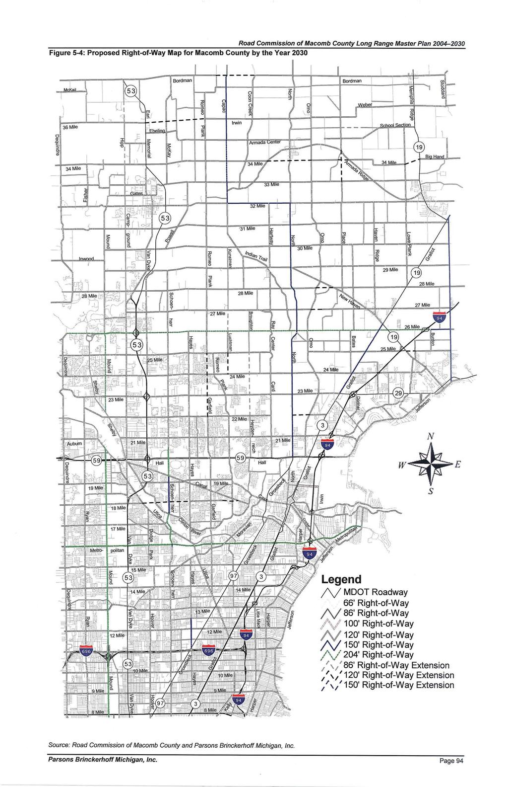
99
100
101 5.7 Role of Local and County Government in Transportation Planning The most cost effective method for developing and maintaining a coordinated and safe transportation system is to form equal partnerships between the County and local levels of government. The County s main role is to maintain roads and bridges and to fund improvements. The role of local municipalities is to develop plans and guidelines that will influence traffic flow and develop land use regulations during the review of development proposals and site plans. The best examples of County-local government partnerships involve a high level of cooperation, coordination, and communication between the different agencies. This section identifies tools available to County and local governments to work together to maintain a safe road system. A number of simple procedures and actions can help foster better communication between the agencies and enhance transportation planning such as: Establish a coordinated development review process (refer to flowchart) Develop access standards Share pertinent information on major developments Local municipalities should notify the County of significant changes to land use plans Provide copies of non-motorized and pathway plans Local municipalities should consider traffic implications of planning on County road system Figure 5-6: Coordinated Development Review Process 1. Applicant submits development proposal to City, Village, or Township (includes land division, subdivision, site plans, or change of use or expansion of existing use) 2. Community forwards development proposal package to Road Commission with a schedule for when proposal is being considered. Community may conduct a study session to discuss issues with the applicant. 3. Road Commission provides comments to the community regarding access and traffic impacts. In some cases, a joint meeting with the applicant may be appropriate. 4. City, Village, or Township takes action on the development proposal, addressing Road Commission comments, as appropriate. 5. After final site plan approval, Road Commission will review and issue access permit(s). If final access varies from that approved by the City, Village, or Township, Road Commission will notify community representatives to determine if site plans must be resubmitted for approval. Page 96


102 5.7.1 Residential Road Design Macomb County currently has standards (in the Subdivision Control Regulations) for development of local roads. These standards are applicable to local roads with a primary function to provide access to abutting residential land, and not serve higher volumes of through traffic. Context Sensitive Design: The recent trend in transportation planning is to promote context sensitive road design and create roads that are of a size and scale that are consistent with the character of the area and not design roads with a one size fits all mentality. The County should establish a hierarchy of local road design for subdivision streets based on road classification, type of land use, intensity of density or development, and individual municipalities needs. Narrower pavement width may be considered to help achieve low speeds and/or preserve natural features. Reductions in road width should be based on the following standards: The road will not offer access to adjacent undeveloped parcels that currently do not have access. The expected traffic volumes along the roadway will be relatively low or the number of units served by the road is relatively low. The abutting development is at a relatively low density. Little on-road parking is anticipated. Figure 5-7: Examples of Context Sensitive Design Context sensitive design, applied to the development of larger parcels, requires the inclusion of through collector roads, particularly where a road can provide for continuity of mile roads and even half-mile roads. Because collector roads will carry relatively higher traffic volumes than other subdivision roads, they may warrant wider pavement widths and additional right-of-way. Figure 5-7 provides examples of context sensitive design. Road Connectivity: For good neighborhood design and community planning, road connectivity is vital. Cul-de-sacs and other dead end roads should be discouraged except in areas where natural features such as wetlands or existing adjacent development patterns preclude through roads. As illustrated in Figure 5-8, a development pattern with a large number of cul-de-sacs creates longer driving distances, isolates adjacent neighborhoods, and forces local trips to always utilize major roads. County Road Commissions, typically limit the length of culde-sacs through subdivision standards Figure 5-8: Example of Road Connectivity Page 97
103 Development on the edge of cities, villages, and other population centers should be required to tie into the existing roadway network. Within a connected roadway system, there are multiple ways for Point A to connect to Point B. This provides motorists with multiple routes and helps to reduce driving distances and diffuse traffic. Connected roads also provide continuous routes that enhance non-motorized transportation. With connected roads, special consideration needs to be given to network design to prevent undesirable cut-through traffic. Requiring connections of local roads is essential to developing a local road network and maintaining the effectiveness of the County's major roads. Providing road connections between adjacent subdivisions allows for the movement between adjacent neighborhoods without the need to access major roads. It also provides alternative means for residents within the subdivisions to access the major roadway network at locations that are most efficient for traveling to their destination, shortening trips, and thereby minimizing traffic impacts to the major road network. It is important that connections between local roads be designed to discourage use by through traffic that does not have an origin or destination within the local neighborhood Access Management Widening and intersection improvements are not the only ways to improve traffic operations along a road. One technique to help preserve capacity and promote safety while delaying or avoiding the need for roadway widening is access management. Access management involves comprehensive controls to minimize conflict points, reduce the potential for crashes, and help preserve the road s ability to carry traffic. Access management protects the public investment in the roadway by minimizing congestion but still provides property owners with reasonable, though not always direct, access. Access management involves a series of tools to reduce traffic conflict points, and thus preserve capacity and improve safety. Access management standards regulate the number, spacing and design of access points, and require the use of shared access systems where practical. Implementation of access management requires a joint effort between the Road Commission and local government in terms of both standards and review. Access Design Guidelines: The Road Commission and local governments are encouraged to work together to establish standards and procedures for access management. These guidelines generally relate to a subdivision or site plan of a particular development that is being reviewed at the local level, but also include the public right-of-way area, which is under the jurisdiction of the road agency (either Michigan Department of Transportation (MDOT) or Road Commission of Macomb County). Thus implementation of guidelines will require coordination with those two agencies so that driveway permits are not granted until the access requirements of the County are met through the site plan approval process. MDOT and a number of Michigan Road Commissions spent considerable time and money and developed the Access Management Guidebook. The County and local municipalities should be familiar with this book and work together towards its implementation. Number of Access Points: The number of access points should be limited to one where practical. Every effort should be made to limit the number of driveways and encourage access off side roads, service drives, frontage roads, and shared driveways. Along major roads, access points should be properly spaced from one another and from intersections with other major roads. Access points should also be aligned with those across the road or properly offset following the accepted standards or guidelines. Some recommended guidelines for major roads are as follows: Page 98

104 Access to a parcel should consist of either a single two-way driveway or a pair of one-way driveways. Certain developments generate enough traffic to consider allowing more than one driveway. Where possible, these second access points should be located on a side road or shared with adjacent uses. One suggested threshold is for uses that are expected to generate over 400 trips in the peak hour of the adjacent road or 4,000 vehicle trips per day. This can be determined by traffic impact studies completed by the developer. For larger parcels with major road frontages an additional driveway may be warranted; additional driveways should only be considered following a traffic impact study which demonstrates the need for additional access. Where parcels have frontage on both a major road and a side road, access should be provided off of the side road. Alternative Access: Alternative access should be encouraged along major roads, such as shared driveways, rear service drives, frontage roads, and connection of parking lots. Figure 5-9 provides an example of alternative access. In some cases certain turning turning-movements should be limited, especially left-turns, where safety hazards may be created or traffic flow may be impeded. Left-turns may be allowed in some situations if improvements are made to the road, such as the installation of a turn or passing lane. In areas within one-quarter mile of existing or future signal locations, access to individual properties should be provided via these alternative access methods rather than by direct connection to a major road. Ideally, this should be through a rear service drive (a rear service drive has adequate depth for on-site stacking, compared to a "frontage" road). In the case of existing, proposed, or Figure 5-9: Example of Alternative Access recommended rear service drives, additional access to individual properties may be allowed through direct connection to the adjacent major road, provided that movements at these driveways are restricted to right-turns into and/or out of the site, and are appropriately spaced as discussed later in this section. In areas where frontage roads or service drives are proposed or recommended but adjacent properties have not yet developed, the site should be designed to accommodate a future drive, with access easements provided. The city may temporarily grant individual properties a direct connection to a major road until the frontage road or service drive is constructed. This access point should be closed when the frontage road or service drive is constructed. Page 99
105 Local governments and the Road Commission should establish standards to address the width, number of intersections, right-of-way setback, driveway throat depth, spacing, location of parking, and separation of frontage roads and service drives. Sight Distance: The minimum sight distance required for a vehicle to enter or exit the traffic stream on a major road from a side road or driveway should be determined by the Road Commission as part of site plan or land division. If adequate sight distance cannot be met, another access location or indirect access through another property should be sought. Driveway Spacing and Location: The spacing of driveways from intersections and other driveways will assist in the reduction of turning movement conflicts. Some general guidelines are as follows: Spacing from Expressway Ramps: A minimum of 600-feet is recommended between expressway ramps and any driveway. Spacing from Intersections: The minimum distance, on the same side of the road, between a driveway and an intersecting road should be 100-feet along a major road and 250-feet from any existing or future signalized intersection. In these cases a right-turn in/ right-turn out driveway could be considered for access, with left turns accommodated through frontage roads or service drives. For non-major roads, spacing from intersections is recommended to be 75-feet. If the amount of road frontage is not sufficient to meet these criteria the driveway should be constructed along the property line farthest from the intersection to encourage future shared use, and/or a frontage road or rear access service drive should be developed. Changes to these guidelines should only be considered if it can be demonstrated by a traffic impact study that the driveway operation will not result in conflicts with vehicles at the adjacent intersection. These guidelines can also generally be applied to spacing from access points on the opposite side of the road. Preferably, major access points should be aligned with, or offset 250 feet from major access points on the opposite side. The actual dimension will vary depending upon existing and expected turning movements. Spacing from Other Driveways. Minimum and desirable driveway spacing requirements should be determined based on posted speed limits along the parcel frontage, based upon the Driveway Spacing Guidelines shown in Table 5-4. The recommended values provided in the table are based on the sight distance necessary to allow an egressing vehicle to enter the major road traffic stream without causing oncoming traffic to decrease their speed by more than 10 miles per hour (mph), and should be required where parcel size permits. The "minimum" values in the table are based on the distances required to avoid conflicts between vehicles turning right or left from adjacent driveways. In order to prevent left-turn conflicts, possible driveways should be aligned with those across the road or offset a sufficient distance from driveways across the road in accordance with the minimum spacing standards listed in the table. Driveway Design: The design of driveways can impact the flow of traffic. Some general guidelines are as follows: Page 100
106 Driveway Width (for non-single family homes): The typical driveway design should include one ingress lane and one egress lane. Wherever exiting traffic volumes or conditions along a major road are expected to cause long delays for exiting traffic (such as where left turns conflict with traffic in the center turn lane of the road, or where trip generation exceeds 1,000 vehicles per day or 100 in the peak hour) two exit lanes should be required. As an alternative, the driveway can be designed with a median dividing the ingress and egress driveways, with a maximum median width of 10- feet. Where median driveways are located across the road from each other, the left-turn egress lanes Table 5-4: Driveway Spacing Guidelines Driveway Spacing Guidelines Posted Speed (mph) Minimum Driveway Spacing* (in feet) Recommended * As measured from the centerline of each driveway. Note: Spacing on boulevards may be adjusted Source: MDOT: The Access Management Guidebook should be aligned to minimize left-turn conflicts. Boulevard driveways should not be constructed at existing or future traffic signal locations, as they often result in driver confusion and poor traffic operations. Restricted Access Driveways: Left-turn movements on and off roadways typically have the greatest impact on traffic flow and crash frequency. Therefore, driveway design and signing can be used to discourage certain turning movements, especially in areas which already have a high crash rate. Deceleration Lanes and Tapers: Where it can be demonstrated that daily driveway volumes are expected to exceed 1,000 vehicles per day, a right-turn taper, deceleration lane and/or left-turn bypass lane may be required. The warrant for a bypass lane is determined through an evaluation of adjacent road traffic levels and the expected number of left-turns into the site. The Road Commission should adopt a left-turn bypass lane warrant analysis which would determine when a bypass lane would be required for a development. This warrant should be available for all local municipalities and required as part of a traffic impact study. Grades and Drainage. Driveways should be constructed to provide adequate drainage but not involve excessive slopes that will make entering or exiting the driveway difficult for vehicles. Surface and Curb Construction: Driveways should be constructed of a permanent asphalt or concrete material and should be paved and curbed from the edge of pavement to either the right-of-way line or point of curvature of the radius returns. Maintenance of Directional Signs and Pavement Markings: In order to ensure smooth traffic circulation on the site, direction signs and pavement markings should be installed at Page 101
107 the driveways as required by the local municipality. This should be part of the site plan review process and approved by MDOT and the Road Commission of Macomb County, and be maintained on a permanent basis by the property owner Traffic Impact Study One procedure to help ensure that traffic impacts are properly evaluated is to require a traffic impact study (TIS). Individual municipalities should require a TIS in their zoning ordinances under certain conditions. The TIS should include the information and procedures recommended in the handbook Evaluating Traffic Impact Studies prepared by MDOT, Southeast Michigan Council of Governments (SEMCOG), and the Tri-County Regional Planning Commission. The TIS should address site access issues, such as the potential to share access or use service drives. The study should analyze options to mitigate traffic impacts, such as changes to access or improvements to the roadway. A copy of the TIS should be provided to the County for review and comment within a specified timeframe. A TIS should be required to evaluate site access points for uses which are expected to generate directional (one-way) trips in the peak hour or 500 trips in an average day. A more detailed TIS should be required which evaluates impacts at site access points and nearby intersections or driveways, for uses which would be expected to generate over 100 peak hour directional trips or 750 or more trips on an average day. Trip generation rates should be based on the most recent edition of Trip Generation published by the Institute of Transportation Engineers (ITE) Right-of-Way Preservation Many roadways in Macomb County were originally designed for much lower traffic volumes than they are expected to handle now or in the future. The right-of-way and development along several roadways limits road widening, intersection improvements, installation of boulevards, and/or the addition of non-motorized pathways. See Figure Acquisition of additional right-of-way to accommodate desired improvements can delay projects and escalate costs. The advance right-of-way acquisition process also reduces later disruption to homes and businesses that would otherwise need to relocate or redesign their site. A cooperative effort to preserve right-of-way in advance of the planned roadway improvements could help address this issue. Four methods that could be considered are negotiations to donate lands during development approvals, advanced acquisition, or preservation through clustering. 1. Donation: Landowners and developers often understand the benefits of donation of land needed for right-of-way. Land donation can expedite improvements that will benefit the landowner. A landowner may also be eligible for tax benefits through donation of dedication. In some cases, the city may wish to support variances from setbacks where the setback from the new right-of-way would create a non-conforming situation. Alternatively, the zoning ordinance could include special standards for such situations. 2. Advance Acquisition: Traditionally, right-of-way is purchased after the improvement has been designed. Advanced acquisition could involve purchase at an earlier date when costs are lower. Some road agencies maintain funds to purchase right-of-way if a development is Page 102

108 proposed where right-of-way will be needed in the future. Thus, the right-of-way can be purchased at a lower cost. 3. Clustering: The municipality might allow a developer to transfer the density that could occur in the future right-of-way to another location on the site through special zoning provisions. 4. Other Zoning Tools. Use of TIS or mitigation as part of the Planned Unit Development or special land use approval process. Using these approaches may enable the community to obtain funding from the developer or proposed projects Corridor Planning and Management The Road Commission can play a key role through coordinating planning along major roadway corridors, as they pass through multiple jurisdictions. Committees should be made up of representatives from the MCRC, MDOT, and local communities along the corridor. These committees would meet regularly to review development proposals, coordinate funding/improvements, and evaluate use of new signals. The committees can provide recommendations for the following: Corridor-wide approach to major development proposals Coordinate driveway access and service drive connections Coordinate right-of-way issues and roadway improvements Plan for non-motorized pathways and transit stops along the corridor Promote unified design for development along corridors Increase funding opportunities through joint initiatives Figure 5-10: Example of Right-of-Way Preservation This procedure is currently being used along M-59 in Livingston County and Range Road in St. Clair County. A multi-jurisdictional corridor advisory committee made up of members from the local units of government, the County, SEMCOG, and MDOT reviews development proposals along the corridor and provides guidance and comments regarding right-of-way preservation and access management. A similar program can be set up in Macomb County Local Community Master Plans Transportation is directly related to land use decisions. Under Michigan planning and zoning laws, land use planning and zoning is the primary responsibility of local governments (Cities, Villages, and Townships with oversight by the County). Land use planning must deal with both the allowable uses within areas of the community and the mobility between the various land use districts. By controlling the intensity of land use, the number of trips generated by the various districts of the community can also be managed. The best tool available for this purpose is an integrated land use/transportation planning process that measures every land use decision against the suitability of the transportation network. A well developed Master Plan must consider plans for land use in the context of transportation planning. In land use planning, decisions are made about where to locate residential developments, industrial employment centers, and commercial areas. The intensity of land uses should, in-part, be considered in relationship to the suitability of the transportation system. More intense development should be channeled to areas where traffic can be accommodated Page 103
109 by existing or proposed transportation systems, with lower densities preserved elsewhere where the transportation infrastructure is more limited. This has the added benefits of enabling transportation agencies to focus efforts on improvements to areas that are planned for greater intensity of development. Through this type of planning, there can be a more efficient provision of transportation, utility, and public infrastructure improvements. Master planning should identify the amount and type of traffic the future land use plan will generate and the effects of this added traffic on the transportation system. In this way, the master plan becomes a proactive tool used to avoid the congestion and safety hazards that may result from looking at individual developments rather than the community development as a whole. 5.8 Recommendations Summary Macomb County has one of the fastest growing townships in Michigan (Macomb Township) and is one of the fastest growing counties in terms of population and employment in Michigan. Due to land development patterns within Macomb County, the southern half of the county has different transportation needs than the northern half. Based on the Existing and No-Build Conditions analyses, roadway improvements were recommended and ranked based on when they should be implemented: short-term, mid-term, and long-term. Preliminary cost estimates were provided for each of the recommendations. The estimated year 2004 cost for the shortterm recommendations is $298,126,000. The estimated year 2004 cost for the mid-term recommendations is $471,517,000. The estimated year 2004 cost for the long-term recommendations is $382,405,000. The total short-term, mid-term, and long-term recommendation cost estimate to address the needs to the year 2030 is estimated at $1,152,048,000 at current funding levels. Proposed right-of-way and roadway classification updates are proposed to address the plan to the year Based on the functional classification of the roadway, the following right-of-way is recommended for the 2030 plan: 66-feet for local roadways 86-feet for collector roadways 100-feet for four-lane undivided roadways 120-feet for five-lane roadways 150-feet for four-lane divided roadways with a median 204-feet for major primary roadways on national highway system or for eight-lane divided roadways The most cost effective method for developing and maintaining a coordinated and safe transportation system is to form equal partnerships between the County and local levels of government. The County s main role is to maintain roads and bridges and to fund improvements. The role of local municipalities is to develop plans and guidelines that will influence traffic flow and develop land use regulations during the review of development proposals and site plans. Additional areas to continue the coordination between agencies are in residential road design, access management, traffic impact studies, right-of-way preservation, corridor planning and management, and local community master plans. Page 104
110 Appendix A: Summary of Public Comments
111 Road Commission of Macomb County Long Range Transportation Master Plan Summary of Comments Received No. of Comments Comment Location Jurisdiction Provider 46 Pave 34 Mile Road from Romeo Plank to Dequindre Bruce Twp RCMC Citizen + Bruce Twp Treasurer Do not widen Cass Avenue from Groesbeck to downtown Mount Mt. Clemens Historic District 29 Clemens, return Cass Avenue to Mount Clemens jurisdiction Mt. Clemens RCMC Study Committee + citizen Type of Comment Roadway No 4 Signal at 34 Mile Road and Van Dyke Bruce Twp RCMC Citizen Intersection 4 Do not pave 34 Mile Road Bruce Twp RCMC Citizen No Roadway 4 Pave Dequindre to County Line Road Bruce Twp RCMC Bruce Twp Treasurer + Citizen 3 Provide non-motorized (bike) lane markings on new or improved roadways or provide adequate shoulders for non-motorized County-wide RCMC Citizen Non-Motorized 3 Subdivision Comments - Maintain Entrances Macomb Twp RCMC Citizen Maintenance 3 Widen 23 Mile Road Macomb Twp RCMC Citizen + Macomb Twp Roadway 3 White edge lines should be provided for all roadways with 12 to 18 inches of roadway extension so vehicles do not immediately leave roadway (provide shoulders) Ray Twp and county-wide RCMC Ray Township Fire & Rescue + Citizen Policy-Design 3 Gravel Roadways need more ditching and drainage Richmond Twp and Bruce Twp RCMC Richmond Twp + Bruce Twp Treasurer + Citizen Maintenance 2 Possible 34 Mile Road / Van Dyke overpass Bruce Twp RCMC Citizen Intersection 2 Connect M-53 freeway to I-69 Bruce Twp and Lapeer County RCMC/Lapeer County/MDOT Citizen New Construction Lenox Twp and Roadway 2 Widen 26 Mile Road County-wide RCMC Lenox Twp + Chesterfield Twp Connect Garfield Road north of 21 Mile Road to ease congestion 2 (up to 25 Mile Road) Macomb Twp RCMC Citizen + Macomb Twp New Construction 2 Replace Bridge on 23 Mile Road east of Romeo Plank Macomb Twp RCMC Citizen Roadway 2 Resurface Hayes between Martin and 13 Mile Road 2 Resurface 12 Mile Road between Hoover and Groesbeck Roseville and Warren Roseville and Warren RCMC RCMC Macomb County Commissioner + City of Roseville Macomb County Commissioner + City of Roseville Roadway Roadway *The Road Commission of Macomb County continually receives and reviews comments from communities and citizens regarding intersection operations and safety. Page 1 of 8
112 No. of Comments Comment Location Jurisdiction Provider 2 Widen and connect 22 Mile Road from Van Dyke to I-94 Shelby Twp, Macomb Twp, Chesterfield Twp RCMC Citizen + Macomb Twp Type of Comment Roadway /Constr uction Roadway 1 Realign Capac Road south of County Line Road Armada Twp RCMC Citizen 1 Additional grading/maintenance of gravel roadways Bruce Twp RCMC Bruce Twp Treasurer Maintenance Roadway 1 Pave East Burdman Road from Scotch Settlement to McKay Bruce Twp RCMC Bruce Twp Treasurer Study / Intersection 1 Concerned with 32 Mile Road and Mound Road intersection* Bruce Twp RCMC Citizen Study / Intersection 1 Concerned with 32 Mile Road and Fisher Road intersection* Bruce Twp RCMC Citizen Study / Intersection 1 Concerned with Ebling Road and Van Dyke Road intersection* Bruce Twp RCMC Citizen Study / Intersection 1 Concerned with 34 Mile Road and Van Dyke Road intersection* Bruce Twp RCMC Citizen Intersection 1 Review intersection at Jefferson and Hall Road* Chesterfield Twp RCMC Chesterfield Twp. Intersection 1 Review intersection at Jefferson and 21 Mile Road* Chesterfield Twp RCMC Chesterfield Twp. Create another entrance/exit ramp off of I-94 between 23 Mile Road 1 and 26 Mile Road - Perhaps at 24 Mile Road Chesterfield Twp MDOT Citizen New Construction Contract with Townships some maintenance work on snow removal 1 and repairs to provide quicker service to residents Chesterfield Twp RCMC Chesterfield Twp. Policy-Funding Roadway 1 Widen Gratiot to 5 lanes between 23 Mile and 26 Mile Road Chesterfield Twp RCMC Chesterfield Twp. Widen Jefferson Avenue to 5 lanes between Rosso Hwy to 23 Mile Roadway 1 Road Chesterfield Twp RCMC Chesterfield Twp. Roadway 1 Widen Sugarbush Road between 21 Mile to 23 Mile Chesterfield Twp RCMC Chesterfield Twp. Roadway 1 Widen and pave Telstar Road off of Gratiot Chesterfield Twp RCMC Chesterfield Twp. Roadway 1 Pave 25 Mile Road Chesterfield Twp RCMC Chesterfield Twp. Roadway 1 Pave Chesterfield Road Chesterfield Twp RCMC Chesterfield Twp. Study / Intersection 1 Review intersection of Cotton and Sugarbush for Signal Chesterfield Twp RCMC Chesterfield Twp. Study / Intersection 1 Review intersection of Callens and Sugarbush for Signal* Chesterfield Twp RCMC Chesterfield Twp. 1 Improve rural roadways for bicyclists County-wide RCMC Citizen Non-Motorized *The Road Commission of Macomb County continually receives and reviews comments from communities and citizens regarding intersection operations and safety. Page 2 of 8
113 No. of Comments Comment Location Jurisdiction Provider Type of Comment 1 Provide continuous left-turn lanes on all roadways if possible County-wide RCMC Citizen Policy-Design 1 Provide additional width on outside travel lane and curb for bicyclists County-wide RCMC Citizen Policy-Design 1 Provide ducts under/through bridge/overpass/intersections during construction - charge duct fees to telecom companies to recoup costs County-wide RCMC / MDOT Citizen - owner of non-utility private fiber optic network Policy-Design 1 Review roadway crown to ensure that drift occurs to the right instead to the left (ex: North between 29 Mile and 32 Mile) County-wide RCMC Ray Township Fire & Rescue Policy-Design 1 Provide residential street design and construction standards County-wide RCMC Shelby Township Planning Director Policy-Design 1 Add standards for pedestrian improvements and access in roadway design County-wide RCMC Shelby Township Planning Director Policy-Design 1 Provide design guidelines for the applicability and design of traffic circles or roundabouts. County-wide RCMC Shelby Township Planning Director Policy-Design More attention needs to be made on construction signing - more Policy-Design / 1 signs, appropriate signs County-wide RCMC / MDOT New Baltimore Councilman Planning Provide sidewalks in areas that are expected to grow fast in the Policy-Design / 1 next twenty years County-wide RCMC New Baltimore Councilman Planning 1 Change county formula funding for roadway improvements County-wide RCMC Macomb County Commissioner Policy-Funding 1 Dust control for gravel roads should be considered maintenance instead of improvement and totally funded by RCMC County-wide RCMC Macomb County Commissioner Policy-Funding 1 Regraveling should be considered maintenance and not improvement and should be proactive instead of reactive County-wide RCMC Macomb County Commissioner Policy-Funding / Maintenance 1 Signage should be provided along roadways to inform motorists to share the roads with bicyclists County-wide RCMC Citizen Policy-Operational 1 Longer-term plan of future right-of-way to reduce utility movement costs County-wide RCMC Citizen - owner of non-utility private fiber optic network Policy-Planning 1 Provide long-term plan to move electrical/telecom services under ground for safety County-wide RCMC Citizen - owner of non-utility private fiber optic network Policy-Planning 1 Provide 100-year plan to pave all non-natural beauty road gravel roads County-wide RCMC Macomb County Commissioner Policy-Planning 1 Pave all primary gravel roadways and change classifications to secondary paved County-wide RCMC Macomb County Commissioner Policy-Planning 1 Coordination meetings should be held between RCMC and local communities County-wide RCMC Macomb County Commissioner Policy-Planning Provide for / allow more input from local communities on roadway 1 projects County-wide RCMC / MDOT New Baltimore Councilman Policy-Planning 1 Coordinate major roadway projects so that multiple construction projects don't occur at the same time County-wide RCMC / MDOT New Baltimore Councilman Policy-Planning *The Road Commission of Macomb County continually receives and reviews comments from communities and citizens regarding intersection operations and safety. Page 3 of 8
114 No. of Comments Comment Location Jurisdiction Provider Type of Comment 1 Review speed limit standards on all roadways to ensure that current classification and land use and speed limits are consistent County-wide RCMC New Baltimore Councilman Policy-Planning 1 Need to plan beyond 2030 to address growing communities County-wide RCMC New Baltimore Councilman Policy-Planning 1 Provide traffic calming techniques to address cut-through traffic and high speeds County-wide RCMC Shelby Township Planning Director Policy-Planning 1 Provide access management standards County-wide RCMC Shelby Township Planning Director Policy-Planning 1 Improve coordination between state, county, and local levels County-wide RCMC Shelby Township Planning Director Policy-Planning 1 Provide standardized procedure for traffic impact studies County-wide RCMC Shelby Township Planning Director Policy-Planning 1 Resurface Jefferson Avenue from Shook to South River Road Harrison Twp RCMC Harrison Twp Supervisor Roadway 1 Improve Bridgeview Bridge over Clinton River, include pedestrian amenities Harrison Twp RCMC Harrison Twp Supervisor Roadway 1 Review intersection for safety at: Jefferson & South River Road, Jefferson & Metropolitan Beach Highway, Metropolitan Beach Highway & Crocker, and Jefferson & Crocker* Harrison Twp RCMC Harrison Twp Supervisor Study / Intersection 1 Lenox Township views 29 Mile Road a major road throughout whole length Lenox Twp RCMC Lenox Twp Policy-Planning 1 Subdivision Comments - Maintain Curb/Gutter Macomb Twp RCMC Citizen Maintenance 1 Construct Broughton Road from 23 Mile to 24 1/2 Mile Road Macomb Twp RCMC Macomb Township New Construction 1 Construct Luchtman Road from 24 Mile to 25 Mile Road Macomb Twp RCMC Macomb Township New Construction 1 Construct Heydenreich Road from 22 Mile to 22 1/2 Mile Road Macomb Twp RCMC Macomb Township New Construction 1 Subdivision Comments - Install more stop signs in subdivisions Macomb Twp RCMC Citizen Policy-Operational 1 Provide shoulders on roadways Macomb Twp RCMC Citizen Policy-Design Provide separate pedestrian/bicycle routes on all planned or 1 proposed bridges Macomb Twp RCMC / MDOT Macomb Township Policy-Design Roadway 1 Pave Luchtman Road from 25 Mile to 26 Mile Road Macomb Twp RCMC Macomb Township 1 Pave 24 Mile Road from Romeo Plank to Foss Road Macomb Twp RCMC Macomb Township Roadway 1 Pave 24 Mile Road from Card Road to North Avenue Macomb Twp RCMC Macomb Township Roadway 1 Pave 24 Mile Road from North Avenue to Fairchild Road Macomb Twp RCMC Macomb Township Roadway 1 Congestion on northbound Romeo Plank at 26 Mile Road, need northbound right-turn lane, turn radius needs improving Macomb Twp RCMC Citizen Study / Intersection 1 Create on-ramp from New Haven Road onto eastbound I-94 New Baltimore MDOT New Baltimore Representative New Construction *The Road Commission of Macomb County continually receives and reviews comments from communities and citizens regarding intersection operations and safety. Page 4 of 8
115 No. of Comments Comment Location Jurisdiction Provider 1 Type of Comment Consider a bike path/pedestrian walk along east side of County Line Road New Baltimore RCMC/Planning New Baltimore Representative Non-Motorized 1 More speed limit signs needed on County Line Road New Baltimore RCMC New Baltimore Representative Policy-Operational 1 Widen 25 Mile Road New Baltimore RCMC Roadway New Baltimore Representative Widen Washington and address geometric problems at Roadway / Intersection 1 intersections New Baltimore RCMC New Baltimore Study / Intersection 1 Review intersection of 24 Mile Road and Washington New Baltimore RCMC New Baltimore Representative 1 Review intersection of 25 Mile Road and County Line New Baltimore RCMC Study / Intersection New Baltimore Representative 1 Reduce speed limit to 45 mph on County Line between 25 Mile Road and M-29 New Baltimore RCMC Study / Roadway New Baltimore Representative 1 Reduce speed limit on 25 Mile Road New Baltimore RCMC Study / Roadway New Baltimore Representative 1 Conduct volume/speed study along County Line Road between M- 29 and 25 Mile Road near new high school and new subdivisions (access management) New Baltimore RCMC Study / Roadway New Baltimore Representative 1 Intersection improvements should have left/thru/right-turn lanes Ray Twp RCMC Ray Township Fire & Rescue Policy-Design 1 Reduce speed limits on gravel roads to 45 mph Ray Twp RCMC Ray Township Supervisor Policy-Operational 1 Congestion on northbound Romeo Plank at 29 Mile Road - review intersection Ray Twp RCMC Citizen Study / Intersection 1 Provide intersection improvements at all major intersections Ray Twp RCMC Ray Township Supervisor Study / Intersection s 1 Provide major east/west and north/south route Ray Twp RCMC Ray Township Supervisor Study / Roadway 1 32 Mile Road bypass or route provided around downtown Romeo Romeo RCMC Citizen Roadway 1 Widen Utica Road to 5 lanes from Gratiot to Groesbeck Roseville RCMC City of Roseville Roadway 1 Widen Hayes Road to 3 lanes from Frazho to 10 Mile Roseville RCMC City of Roseville Roadway 1 Widen 14 Mile Road to 5 lanes from Kelly to Gratiot Roseville RCMC City of Roseville Roadway 1 Connect Hayes Road between Groesbeck and Martin Road Roseville/Warren RCMC City of Roseville New Construction 1 Provide additional on-ramps at 23 Mile Road and M-53: EB 23 Mile Road to NB M-53 and WB 23 Mile Road to SB M-53 Shelby Twp MDOT Shelby Township Planning Director *The Road Commission of Macomb County continually receives and reviews comments from communities and citizens regarding intersection operations and safety. New Construction Page 5 of 8
116 No. of Comments Comment Location Jurisdiction Provider Type of Comment Shelby Township Planning Roadway 1 Widen Van Dyke from 23 to 24 1/2 Mile Road Shelby Twp RCMC Director 1 Widen Van Dyke from 24 1/2 Mile to 26 Mile Road Shelby Twp RCMC Shelby Township Planning Director Roadway 1 Widen 26 Mile Road from M-53 to east of Hayes Shelby Twp RCMC Shelby Township Planning Director Roadway 1 Redesign and reconstruct turn-around lanes on 26 Mile Road between Stoney Creek to M-53 Shelby Twp RCMC Shelby Township Planning Director Roadway 1 Review intersection of 26 Mile Road and new signal at school east of M-53, concern with new left-turn pocket and alignment of through lanes Shelby Twp RCMC Citizen Study / Intersection 1 Construct a roundabout at Hayes and 25 Mile Road Shelby Twp RCMC Shelby Township Planning Director Study / Intersection 1 Review Auburn Road and Dequindre intersection* Shelby Twp RCMC/RCOC Shelby Township Planning Director Study / Intersection 1 Review 26 Mile Road and Mound Road intersection* Shelby Twp RCMC Shelby Township Planning Director Study / Intersection 1 Update west Utica Road and Dequindre Road intersection Shelby Twp RCMC/RCOC Shelby Township Planning Director Study / Intersection 1 Consider more bike routes/paths along roadways - Jefferson Avenue or Harper Avenue St. Clair Shores RCMC AEW Non-Motorized 1 Provide design alternatives/cost estimates/benefit-cost ratio for bituminous resurfacing versus remove and replace St. Clair Shores RCMC AEW Policy-Design 1 Provide design alternatives/cost estimates/benefit-cost ratio for partial depth patching versus full depth patching St. Clair Shores RCMC AEW Policy-Design 1 Resurface Harper between 11 Mile and Grossedale St. Clair Shores RCMC AEW Roadway 1 Resurface Harper between Grossedale and 14 Mile Road St. Clair Shores RCMC AEW Roadway 1 Resurface 12 Mile Road between Harper and Little Mack St. Clair Shores RCMC AEW Roadway 1 Resurface 10 Mile Road between Harper and I-94 St. Clair Shores RCMC AEW Roadway 1 Pavement patching on Harper between 8 Mile and 11 Mile St. Clair Shores RCMC AEW Roadway 1 Roundabout at Harper and Little Mack St. Clair Shores RCMC AEW Study / Intersection 1 Corridor Study for Harper Avenue in St. Clair Shores St. Clair Shores RCMC AEW Study / Roadway 1 Review signal at Clinton River Road and Schoenherr* Sterling Heights RCMC City of Sterling Heights Intersection *The Road Commission of Macomb County continually receives and reviews comments from communities and citizens regarding intersection operations and safety. Page 6 of 8
117 No. of Comments Comment Location Jurisdiction Provider Type of Comment 1 Review signal at 19 Mile and Michigan* Sterling Heights RCMC City of Sterling Heights Intersection 1 Review intersection at 19 Mile and Hayes Road* Sterling Heights RCMC City of Sterling Heights Intersection 1 Review intersection at Hayes Road and Canal Road* Sterling Heights RCMC City of Sterling Heights Intersection 1 Build 18 Mile from Utica to Hayes to 5 lanes Sterling Heights RCMC City of Sterling Heights New Construction 1 Build 19 Mile from Van Dyke to Hayes to 5 lanes Sterling Heights RCMC City of Sterling Heights New Construction 1 Widen 19 Mile from Ryan to Mound to 5 lanes Sterling Heights RCMC City of Sterling Heights Roadway 1 Widen 19 Mile from Dequindre to Ryan to 5 lanes Sterling Heights RCMC City of Sterling Heights Roadway 1 Widen 18 1/2 Mile from Mound to Van Dyke to 5 lanes Sterling Heights RCMC City of Sterling Heights Roadway 1 Widen 18 Mile from Dequindre to Utica to 5 lanes Sterling Heights RCMC City of Sterling Heights Roadway 1 Widen Dodge Park from 16 Mile to Utica to 5 lanes Sterling Heights RCMC City of Sterling Heights Roadway 1 Widen 19 Mile from Mound to Van Dyke to 5 lanes Sterling Heights RCMC City of Sterling Heights Roadway 1 Widen Schoenherr from 16 Mile to Canal to 6 lanes Sterling Heights RCMC City of Sterling Heights Roadway 1 Widen Utica from Van Dyke to Hayes to 5 lanes Sterling Heights RCMC City of Sterling Heights Roadway 1 Widen Mound from 17 Mile to M-59 to 8 lanes Sterling Heights RCMC City of Sterling Heights Roadway 1 Widen Moravian from Schoenherr to Hayes to 5 lanes Sterling Heights RCMC City of Sterling Heights Roadway 1 Widen Clinton River Road from Canal to Hayes to 4 lanes Sterling Heights RCMC City of Sterling Heights Roadway *The Road Commission of Macomb County continually receives and reviews comments from communities and citizens regarding intersection operations and safety. Page 7 of 8
118 Road Commission of Macomb County Long Range Transportation Master Plan Number of Comments Received Mail Fax Phone Meeting Total Citizen Municipality Representative Community Representative Total Municipalities that responded: Armada Township Bruce Township Chesterfield Township Harrison Township Macomb Township New Baltimore Ray Township Richmond Township Roseville Shelby Township St. Clair Shores Sterling Heights Page 8 of 8
119 Appendix B: Short-Term, Mid-Term, and Long-Term Deficient Bridges
120 Road Commission of Macomb County Critical Bridges Included Under Short-Term Recommendations Becomes Year Critical by Total Funds STRC_NUM FACILITY FEATINT Year Built Reconstructed Length Year Allocated* MILE RD MIDDLE BR CLINTON RIVER MILE ROAD NORTH BRANCH CLINTON R MILE ROAD DEER CREEK MILE ROAD KIRKHAM DRAIN MILE ROAD BRANCH OF KIRKHAM DRAIN MILE ROAD HEALY BROOK DRAIN EARL MEM HWY M B CLINTON RIVER JEFFERSON AVE VENTRE DE BEUF LAKESHORE DRIVE CHANNEL TO LAKE ST CLAIR PARDEE ROAD CHANNEL TO LAKE ST CLAIR EAST ARCHER DRIVE CHANNEL TO LAKE ST CLAIR CHAPMAN ROAD DEER CREEK WOLCOTT ROAD N BRANCH CLINTON RIVER MILE ROAD EAST BRANCH COON CREEK $1,120, MILE ROAD HEALY BROOK DRAIN $600, BRIDGEVIEW CLINTON R & OLD N R RD $4,000, IRWIN ROAD EAST BRANCH COON CREEK $600, HAGEN ROAD DEER CREEK $650, MILE ROAD N B CLINTON RIVER MILE ROAD RED RUN DRAIN $1,400, MILE ROAD CEMETERY CREEK LAKESHORE DRIVE CHANNEL TO LAKE ST CLAIR SHOOK ROAD CLINTON HARRISON DRAIN NEW HAVEN RD DEER CREEK BORDMAN ROAD N B CLINTON RIVER BATES ROAD DEER CREEK HAYES ROAD PRICE BROOK DRAIN MILE ROAD HIGHBANK CREEK Total Funds Allocated: $8,370,000 Note: Macomb County considers the bridges listed on this worksheet as critical; therefore, they will be included in short-term recommendations regardless of the age of the bridge. Bolded Year: Indicates funding is available and is included in the county bridge program to be rehabilitated/reconstructed in that year Total Funds Allocated* = Obtained from the County Bridge Program 5 Year Work Plan
121 Critical Bridges Short-Term Recommendations Becomes Year Critical by Total Funds STRC_NUM FACILITY FEATINT Year Built Reconstructed Length Year Allocated* EB METRO PARKWAY HARRINGTON DRAIN WB METRO PARKWAY HARRINGTON DRAIN EB METRO PARKWAY CLINTON RIVER SPILLWAY MILE ROAD MCBRIDE DRAIN MILE ROAD DEER CREEK MILE ROAD KIRKHAM DRAIN MILE ROAD BRANCH OF KIRKHAM DRAIN MILE ROAD HEALY BROOK DRAIN MILE ROAD CAMP BROOK DRAIN ARMADA RIDGE ROAD HIGHBANK CREEK ARMADA CENTER RD COON CREEK EARL MEM HWY M B CLINTON RIVER HARPER AVE CLINTON RIVER SPILLWAY JEFFERSON AVE CLINTON RIVER SPILLWAY JEFFERSON AVE VENTRE DE BEUF JEFFERSON AVE SALT RIVER PRATT ROAD EAST BRANCH COON CREEK MC FADDEN ROAD NEWLAND DRAIN ELDRED ROAD EAST MILL LAKE OUTLET LITTLE ROAD NORTH BRANCH CLINTON R LAKESHORE DRIVE CHANNEL TO LAKE ST CLAIR PARDEE ROAD CHANNEL TO LAKE ST CLAIR EAST ARCHER DRIVE CHANNEL TO LAKE ST CLAIR CARD ROAD NORTH BR CLINTON RIVER MILE ROAD SALT SLANG GLOEDE DRAIN CHAPMAN ROAD DEER CREEK MILE ROAD HEALY BROOK DRAIN MILE ROAD OVERFLOW N B CLINTON WOLCOTT ROAD N BRANCH CLINTON RIVER MILE ROAD MIDDLE BRANCH CLINTON R BELLMAN ROAD MIDDLE BRANCH CLINTON R METZ ROAD MIDDLE BRANCH CLINTON R DICKINSON ST CLINTON RIVER ASHLEY ST CRAPEAU CREEK BASE ST CRAPEAU CREEK BEACH STREET LAKE ST. CLAIR CANAL LANGE STREET LAKE ST. CLAIR SHORES ROMEO PLANK RD GLOEDE DRAIN $3,500, NEW HAVEN RD E B COON CREEK MILE ROAD DEER CREEK $600, MILE ROAD STONY CREEK $650, MT VERNON ROAD STONY CREEK $420, Shelby Road Conrail $400, Lowe Plank Tributary Salt River $425, MILE ROAD BEAR CREEK MOUND ROAD SHARKEY DRAIN BORDMAN ROAD EAST BRANCH COON CREEK $600, MCVICAR ROAD EAST POND CREEK MILE ROAD MCBRIDE DRAIN MILE ROAD CEMETERY CREEK $520, Lowe Plank Salt River $400, IRWIN ROAD COON CREEK $520, MILE ROAD N BRANCH CLINTON RIVER $1,320, MILE ROAD N B CLINTON RIVER $1,430, MILE ROAD NORTH BRANCH CLINTON R $1,650, CAMP GROUND ROAD EAST MILL LAKE OUTLET Total Funds Allocated: $12,435,000 Note: Bolded Year: Indicates funding is available and is included in the county bridge program to be rehabilitated/reconstructed in that year Total Funds Allocated* = Obtained from the County Bridge Program 5 Year Work Plan
122 Critical Bridges Mid-Term Recommendations Becomes STRC_NUM FACILITY FEATINT Year Year Built Reconstructed Length Critical by Year JEFFERSON AVE MILK RIVER ROSEDALE STREET MILK RIVER THIRTEEN MILE ROAD BEAR CREEK DRAIN CROCKER BLVD CLINTON RIVER INWOOD ROAD STONY CREEK MILE ROAD STONY CREEK DENTON DRIVE RED RUN DRAIN MILE ROAD N BR CLINTON RIVER MILE RD. HARRINGTON DRAIN MILE ROAD MIDDLE BRANCH CLINTON R MILE ROAD NORTH BRANCH CLINTON R MILE ROAD TUPPER BROOK DRAIN CALLENS ROAD FISH CREEK DUNHAM ROAD MILLER DRAIN HARPER AVE CLINTON HARRISON DRAIN HICKS ROAD COON CREEK NORTH AVE E B COON CREEK QUINN ROAD CLINTON HARRISON DRAIN ROMEO PLANK RD N B CLINTON RIVER RYAN ROAD CLINTON RIVER WB METRO PARKWAY CLINTON RIVER SPILLWAY MILE RD SWEENEY DRAIN MILE ROAD PLUMBROOK DRAIN MILE ROAD NEWLAND DRAIN MILE ROAD COON CREEK NEW HAVEN RD SALT RIVER SEAWAY DRIVE CANAL TO SEAWAY ISLAND MILE RD SECORD LAKE OUTLET NORTH RIVER ROAD CATFISH CHANNEL MILE ROAD SALT SLANG GLOEDE DRAIN MILE ROAD NORTH BRANCH CLINTON R MILE ROAD COON CREEK WASHINGTON ST CREPEAU CREEK MILE ROAD YATES DRAIN MILE ROAD PRICE BROOK DRAIN MILE ROAD LEWIS DRAIN NORTH AVENUE DEER CREEK MILE ROAD MIDDLE BR CLINTON RIVER
123 Critical Bridges Long-Term Recommendations STRC_NUM FACILITY FEATINT Year Built Year Reconstructed Length Becomes Critical by Year MILE ROAD COON CREEK MILE ROAD TUPPER BROOK DRAIN MILE ROAD EAST MILL LAKE OUTLET SCHOENHERR ROAD MIDDLE BR CLINTON RIVER WB METRO PARKWAY RED RUN DRAIN MORAVIAN DR. CLINTON RIVER DEQUINDRE ROAD RED RUN DRAIN JEWELL ROAD YATES DRAIN WEBER ROAD BEAVER CREEK MILE ROAD OVERFLOW E B COON CREEK COON CREEK ROAD COON CREEK IRWIN ROAD NEWLAND DRAIN ROMEO PLANK ROAD NEWLAND DRAIN SCHOENHERR ROAD STERLING RELIEF DRAIN VAN DYKE AVE CLINTON RIVER WEBER ROAD BELLE RIVER OVERFLOW MILE ROAD MIDDLE BR CLINTON RIVER MILE ROAD HEALY BROOK DRAIN MILE ROAD TUPPER BROOK DRAIN MILE ROAD COON CREEK MILE ROAD N BRANCH CLINTON RIVER BATES ROAD DEER CREEK HAYES ROAD MIDDLE BR CLINTON RIVER HOLMES ROAD NEWLAND DRAIN KUNSTMAN ROAD CAMP BROOK DRAIN MILE RD BIG BEAVER CREEK DODGE PARK RD PLUM BROOK DRAIN JEWELL ROAD MIDDLE BR CLINTON RIVER BROWN ROAD N B CLINTON RIVER NEW HAVEN RD COON CREEK SOUTH RIVER RD CHANNEL BETW LAKE & RIVR MILE ROAD COON CREEK ARMADA CENTER RD. NEWLAND DRAIN MILE ROAD E B COON CREEK CASS AVE NORTH BRANCH CLINTON RIV MILE ROAD COON CREEK CLINTON RIVER RD KUKUK DRAIN MOUND ROAD STERLING RELIEF DRAIN NORTH AVE E B COON CREEK DODGE PARK RD STERLING RELIEF DRAIN NORTH AVE COON CREEK ROMEO PLANK RD HEALY BROOK DRAIN ROMEO PLANK RD HEALY BROOK DRAIN SCHOENHERR RD RED RUN DRAIN MILE ROAD HIGHBANK CREEK TELLER ROAD CAMP BROOK DRAIN TILCH RD DUNN-BANISTER DRAIN
124 Appendix C: Short-Term and Mid-Term Pavement Rankings
125 Appendix C provides the roadway segments that have pavement rankings as either poor to failed or fair. These segments are included in the short-term and mid-term recommendations. Short-Term Recommendations ( ) Reconstruct or rehabilitate pavement ranked as either poor to failed: Little Road from Dunham Road to north of Dunham Road Hayes Road between 12 Mile Road and Common Road Quinn Road between Gratiot Avenue and I-94 Jefferson Avenue from 21 Mile Road to Dock Road Hayes Road between Martin Road and 12 Mile Road Mid-Term Recommendations ( ) Reconstruct or rehabilitate pavement ranked as fair: 9 Mile Road between Dequindre Road and Ryan Road (Warren) 9 Mile Road between Mound Road and Van Dyke Avenue (Warren) Stephens Road between Van Dyke Avenue and Hoover Road (Warren) 9 Mile Road between Hoover Road and Schoenherr Road (Warren) 9 Mile Road between Schoenherr Road and Hayes Road (Warren) 9 Mile Road between David Road and Kelly Road (Eastpointe) 12 Mile Road between Groesbeck Highway and I-94 Masonic Boulevard between Utica Road and Kelly Road (Fraser) Hayes Road between 14 Mile Road to south of 13 Mile Road Garfield Road between Utica Road and 15 Mile Road 14 Mile Road between Greater Mack Avenue to east of Kelly Road 15 Mile Road between Little Mack and Harper Avenue Rathbone Road between Dickinson and Avery Road (Mt. Clemens) Henry B Joy between Irwin Road and Gratiot Avenue Elizabeth Road between North Avenue and Gratiot Avenue Maple Lane Road between 14 Mile Road and Volpe Road (Sterling Heights) Plumbrook Road between Schoenherr Road and Dodge Park (Sterling Heights) Bordman Road between Deland Road to east of Wahl Road 18 Mile Road between Garfield Road to east of Garfield Road
126 Appendix D: Original Right-of-Way Map for Macomb County
127


128 535 Griswold Street, Suite 1525 Detroit, Michigan Fax:
JONESBORO HIGHWAY 63 HIGHWAY 18 CONNECTOR STUDY
 JONESBORO HIGHWAY 63 HIGHWAY 18 CONNECTOR STUDY Craighead County May 2007 JONESBORO HIGHWAY 63 HIGHWAY 18 CONNECTOR STUDY Craighead County May 2007 Prepared by Planning and Research Division Arkansas State
Mobility and Congestion
 Technical Memorandum Mobility and Congestion Prepared for: Prepared by: September 25, 2013 1 Table of Contents 1. Introduction... 1 2. Congestion Forecasting Process... 1 2.1 Mobility and Congestion Terms...
City of Homewood Transportation Plan
 City of Homewood Transportation Plan Prepared for: City of Homewood, Alabama Prepared by: Skipper Consulting, Inc. May 2007 TABLE OF CONTENTS INTRODUCTION... 1 BACKGROUND INFORMATION... 1 EXISTING TRANSPORTATION
Gratiot Avenue Transit Study Tech Memo #4: Ridership
 Gratiot Avenue Transit Study Tech Memo #4: Ridership 5/31/2016 Table of Contents 1 INTRODUCTION... 3 PROJECT DESCRIPTION... 3 2 TECH MEMO #4 OVERVIEW... 5 METHODOLOGY... 5 3 THE ALTERNATIVES AND POTENTIAL
City of Wayzata Comprehensive Plan 2030 Transportation Chapter: Appendix A
 A1. Functional Classification Table A-1 illustrates the Metropolitan Council s detailed criteria established for the functional classification of roadways within the Twin Cities Metropolitan Area. Table
Route 7 Corridor Study
 Route 7 Corridor Study Executive Summary Study Area The following report analyzes a segment of the Virginia State Route 7 corridor. The corridor study area, spanning over 5 miles in length, is a multi
Chapter 4 Traffic Analysis
 Chapter 4 Traffic Analysis PURPOSE The traffic analysis component of the K-68 Corridor Management Plan incorporates information on the existing transportation network, such as traffic volumes and intersection
Clackamas County Comprehensive Plan
 ROADWAYS The County s road system permits the movement of goods and people between communities and regions, using any of a variety of modes of travel. Roads provide access to virtually all property. They
TRANSPORTATION ANALYSIS REPORT US Route 6 Huron, Erie County, Ohio
 TRANSPORTATION ANALYSIS REPORT US Route 6 Huron, Erie County, Ohio December 12, 2012 Prepared for: The City of Huron 417 Main Huron, OH 44839 Providing Practical Experience Technical Excellence and Client
5.0 Roadway System Plan
 Southwest Boise Transportation Study Page 16 5.0 Roadway System Plan The Roadway System Plan outlines roadway improvements in the Initial Study Area. It forecasts future deficiencies on the arterial system,
M-58 HIGHWAY ACCESS MANAGEMENT STUDY Mullen Road to Bel-Ray Boulevard. Prepared for CITY OF BELTON. May 2016
 M-58 HIGHWAY ACCESS MANAGEMENT STUDY Prepared for CITY OF BELTON By May 2016 Introduction Missouri State Highway 58 (M-58 Highway) is a major commercial corridor in the City of Belton. As development has
o n - m o t o r i z e d transportation is an overlooked element that can greatly enhance the overall quality of life for the community s residents.
 N o n - m o t o r i z e d transportation is an overlooked element that can greatly enhance the overall quality of life for the community s residents. 84 Transportation CHAPTER 11 INTRODUCTION Transportation
Highway 49, Highway 351 and Highway 91 Improvements Feasibility Study Craighead County
 Highway 49, Highway 351 and Highway 91 Improvements Feasibility Study Craighead County Executive Summary March 2015 Highway 49, Highway 351 and Highway 91 Improvements Feasibility Study Craighead County
Highway 111 Corridor Study
 Highway 111 Corridor Study June, 2009 LINCOLN CO. HWY 111 CORRIDOR STUDY Draft Study Tea, South Dakota Prepared for City of Tea Sioux Falls Metropolitan Planning Organization Prepared by HDR Engineering,
PRELIMINARY DRAFT FIRST AMENDMENT TO VISION 2050: A REGIONAL LAND USE AND TRANSPORTATION PLAN FOR SOUTHEASTERN WISCONSIN
 PRELIMINARY DRAFT FIRST AMENDMENT TO VISION 2050: A REGIONAL LAND USE AND TRANSPORTATION PLAN FOR SOUTHEASTERN WISCONSIN ESTABLISHING TARGETS FOR FEDERAL PERFORMANCE MEASURES: HIGHWAY SAFETY SOUTHEASTERN
Access Management Regulations and Standards
 Access Management Regulations and Standards Efficient highway operation Reasonable property access Concept of Access Management The way to manage access to land development while simultaneously preserving
APPENDIX G: INTERSECTION NEEDS AT OKEECHOBEE BOULEVARD
 APPENDIX G: INTERSECTION NEEDS AT OKEECHOBEE BOULEVARD INTERSECTION NEEDS AT SR 7 and OKEECHOBEE BOULEVARD SR 7 Extension Project Development and Environment (PD&E) Study From Okeechobee Boulevard (SR
CHAPTER THREE MOBILITY
 CHAPTER THREE MOBILITY 70 MAJOR THOROUGHFARES Operations. The City of Ames is served by a combination of federal, state and local highways/streets that are interlinked in creating a regional and inter-city
Regional Transportation Needs Within Southeastern Wisconsin
 Regional Transportation Needs Within Southeastern Wisconsin #118274 May 24, 2006 1 Introduction The Southeastern Wisconsin Regional Planning Commission (SEWRPC) is the official areawide planning agency
TRAFFIC IMPACT ANALYSIS
 TRAFFIC IMPACT ANALYSIS FOR THE CHAMPAIGN UNIT#4 SCHOOL DISTRICT PROPOSED HIGH SCHOOL (SPALDING PARK SITE) IN THE CITY OF CHAMPAIGN Final Report Champaign Urbana Urbanized Area Transportation Study 6/24/2014
Subject: Solberg Avenue / I-229 Grade Separation: Traffic Analysis
 MEMORANDUM Transportation Bill Troe, AICP Jason Carbee, AICP 12120 Shamrock Plaza Suite 300 Omaha, NE 68154 (402) 334-8181 (402) 334-1984 (Fax) To: Project File Date: Subject: Solberg Avenue / I-229 Grade
3 ROADWAYS 3.1 CMS ROADWAY NETWORK 3.2 TRAVEL-TIME-BASED PERFORMANCE MEASURES Roadway Travel Time Measures
 ROADWAYS Approximately 6 million trips are made in the Boston metropolitan region every day. The vast majority of these trips (80 to percent, depending on trip type) involve the use of the roadway network
ADOT Statewide Bicycle and Pedestrian Program Summary of Phase IV Activities APPENDIX B PEDESTRIAN DEMAND INDEX
 ADOT Statewide Bicycle and Pedestrian Program Summary of Activities APPENDIX B PEDESTRIAN DEMAND INDEX May 24, 2009 Pedestrian Demand Index for State Highway Facilities Revised: May 29, 2007 Introduction
TRAFFIC STUDY GUIDELINES Clarksville Street Department
 TRAFFIC STUDY GUIDELINES Clarksville Street Department 9/1/2009 Introduction Traffic studies are used to help the city determine potential impacts to the operation of the surrounding roadway network. Two
Waterford Lakes Small Area Study
 Waterford Lakes Small Area Study Existing Traffic Conditions PREPARED FOR: ORANGE COUNTY PUBLIC WORKS DEPARTMENT TRAFFIC ENGINEERING DIVISION ORLANDO, FLORIDA PREPARED WITH: INWOOD CONSULTING ENGINEERS
Classification Criteria
 SCHEDULE D TO RECOMMENDED OFFICIAL PLAN AMENDMENT NO. 40 SCHEDULE C-4 Road Criteria Criteria Traffic Service Objective Land Service/Access Typical Daily Traffic Volume Flow characteristics Travel Speed
METHODOLOGY. Signalized Intersection Average Control Delay (sec/veh)
") Chapter 5 Traffic Analysis 5.1 SUMMARY US /West 6 th Street assumes a unique role in the Lawrence Douglas County transportation system. This principal arterial street currently conveys commuter traffic
Chapter 5 Traffic Analysis 5.1 SUMMARY US /West 6 th Street assumes a unique role in the Lawrence Douglas County transportation system. This principal arterial street currently conveys commuter traffic
Executive Summary June 2015
 Executive Summary June 2015 Highway 112 Corridor Study Benton and Washington Counties Executive Summary June 2015 Prepared by Transportation Planning and Policy Division Arkansas State Highway and Transportation
West Dimond Blvd Upgrade Jodhpur Street to Sand Lake Road
 West Dimond Blvd Jodhpur St to Sand Lake CSS Transportation Project Summary Municipality of Anchorage Project # 05 005 Project Manager: John Smith, P.E. (MOA PM&E) Project Administrator: Julie Makela,
CHAPTER 7 ACCESS MANAGEMENT. Background. Principles of Access Management. Hennepin County Transportation Systems Plan (HC-TSP)
") CHAPTER 7 ACCESS MANAGEMENT Background Principles of Access Management Hennepin County Transportation Systems Plan (HC-TSP) Chapter 7 Access Management 7.1 Background Access management has become an important
CHAPTER 7 ACCESS MANAGEMENT Background Principles of Access Management Hennepin County Transportation Systems Plan (HC-TSP) Chapter 7 Access Management 7.1 Background Access management has become an important
Chapter 5 FUNCTIONAL CLASSIFICATION
 Chapter 5 FUNCTIONAL CLASSIFICATION Functional classification is a system by which streets and roadways may be distinguished by types according to their function within the entire transportation network.
TRAFFIC IMPACT STUDY CRITERIA
 Chapter 6 - TRAFFIC IMPACT STUDY CRITERIA 6.1 GENERAL PROVISIONS 6.1.1. Purpose: The purpose of this document is to outline a standard format for preparing a traffic impact study in the City of Steamboat
4. ENVIRONMENTAL IMPACT ANALYSIS 9. TRANSPORTATION AND TRAFFIC
 4. ENVIRONMENTAL IMPACT ANALYSIS 9. TRANSPORTATION AND TRAFFIC 4.9.1 INTRODUCTION The following section addresses the Proposed Project s impact on transportation and traffic based on the Traffic Study
Phone: Fax: Project Reference No. (to be filled out by MassHighway):
:") Massachusetts Highway Department District 3 Project Need Form (PNF) This form is intended to provide preliminary information about the proposed project. It is not expected that all information that is
Massachusetts Highway Department District 3 Project Need Form (PNF) This form is intended to provide preliminary information about the proposed project. It is not expected that all information that is
APPENDIXB. Traffic Operations Technical Memorandum
 APPENDIXB Traffic Operations Technical Memorandum Environmental Assessment - Lincoln County, SD 85 th Street: Sundowner Avenue to Louise Avenue November 2017 MEMORANDUM Transportation Jim Kollbaum, PE
APPENDIX C. Systems Performance Report C-1
 APPENDIX C Systems Performance Report C-1 System Performance Report & Requirements According to the FAST Act, a long range transportation plan needs to include a system performance report and subsequent
Lee s Summit, Missouri Thoroughfare Master Plan
 Title Text Interstate Reg. 12 pt. Lee s Summit, Missouri Thoroughfare Master Plan April 2006 Lee s Summit, Missouri Thoroughfare Master Plan i Table of Contents Chapter 1 Introduction 1.1 Purpose of the
EXISTING (2006) CONDITIONS
 CONDITIONS") Section 2 EXISTING (2006) CONDITIONS This section provides a description of the existing transportation system in the study area and a comprehensive analysis of existing traffic operations and crash history.
Section 2 EXISTING (2006) CONDITIONS This section provides a description of the existing transportation system in the study area and a comprehensive analysis of existing traffic operations and crash history.
3.0 Future Conditions
 3.0 Future Conditions In order to be able to recommend appropriate improvements to the transportation system of the Town, it is important to first understand the nature and volume of traffic that is expected
Intersection Traffic Control Feasibility Study
 Intersection Traffic Control Feasibility Study CSAH 9 at CSAH 60 (185th Avenue) Prepared For: Dakota County Transportation Department Western Service Center 14955 Galaxie Avenue, 3rd Floor Apple Valley,
Highway 217 Corridor Study. Phase I Overview Report
 Highway 217 Corridor Study Phase I Overview Report November 3, 24 BACKGROUND AND OVERVIEW Study purpose The Highway 217 Corridor Study is developing multi-modal transportation solutions for traffic problems
EXECUTIVE SUMMARY OF CALEDON TRANSPORTATION NEEDS STUDY
 EXECUTIVE SUMMARY OF CALEDON TRANSPORTATION NEEDS STUDY The Caledon Transportation Needs Study has been undertaken as a joint project by the Town of Caledon and the Region of Peel to determine the existing
City of Gainesville Transportation/Roadway Needs PROJECT SUMMARY
 A1 Roadway Resurfacing $23,846,000 TYPE: Preservation of existing system Roadway resurfacing A2 Signal Replacement $6,000,000 TYPE: Preservation of existing system Replace traffic signals. B1 W 6th St
APPENDIX H EXISTING TRAFFIC CONDITIONS ANALYSIS
 APPENDIX H EXISTING TRAFFIC CONDITIONS ANALYSIS MEMO : Peter Steacy, P.Eng. Date: December 3, 2014 : Ian Borsuk, P.Eng. Job No.: 3414015-000 Subject: City of Ottawa O-Train Extension Planning & EA Study
CHAPTER 4: IDENTIFICATION OF ROAD SYSTEM DEFICIENCIES: TRANSPORTATION PLANNING MODEL
 CHAPTER 4: IDENTIFICATION OF ROAD SYSTEM DEFICIENCIES: TRANSPORTATION PLANNING MODEL I. INTRODUCTION Transportation planning models are the primary tools used to predict future travel conditions. With
Overview. Existing Conditions. Corridor Description. Assessment
 Overview A study of the 23 rd Street corridor was undertaken to document the existing conditions, analyze traffic operations, and recommend remedies for deficient situations Although 23 rd Street is frequently
# Southeastern Wisconsin Regional Freeway System Reconstruction Study and Preliminary Recommended Plan
 #70421 Southeastern Wisconsin Regional Freeway System Reconstruction Study and Preliminary Recommended Plan Public Information Meetings and Hearings May June 2002 1 Reason for Freeway System Study 270-mile
CITY OF ALPHARETTA DOWNTOWN MASTER PLAN TRAFFIC EVALUATION
 CITY OF ALPHARETTA DOWNTOWN MASTER PLAN TRAFFIC EVALUATION June 2015 CITY OF ALPHARETTA DOWNTOWN MASTER PLAN TRAFFIC EVALUATION Introduction The Alpharetta Downtown Master Plan was developed in the fall
ENHANCED PARKWAY STUDY: PHASE 2 CONTINUOUS FLOW INTERSECTIONS. Final Report
 Preparedby: ENHANCED PARKWAY STUDY: PHASE 2 CONTINUOUS FLOW INTERSECTIONS Final Report Prepared for Maricopa County Department of Transportation Prepared by TABLE OF CONTENTS Page EXECUTIVE SUMMARY ES-1
appendix b BLOS: Bicycle Level of Service B.1 Background B.2 Bicycle Level of Service Model Winston-Salem Urban Area
 appendix b BLOS: B.1 Background Winston-Salem Urban Area Bicycle Level of Service Level of Service (LOS) is a framework that transportation professionals use to describe existing conditions (or suitability)
TRASBURG RANSPORTATION
 TRASBURG RANSPORTATION LAN DEVELOPED BY THE TRANSPORTATION PLANNING DIVISION OF THE VIRGINIA DEPARTMENT OF TRANSPORTATION IN COOPERATION WITH THE U.S. DEPARTMENT OF TRANSPORTATION, FEDERAL HIGHWAY ADMINISTRATION
5858 N COLLEGE, LLC N College Avenue Traffic Impact Study
 5858 N COLLEGE, LLC nue Traffic Impact Study August 22, 2016 Contents Traffic Impact Study Page Preparer Qualifications... 1 Introduction... 2 Existing Roadway Conditions... 5 Existing Traffic Conditions...
Basalt Creek Transportation Refinement Plan Recommendations
 Basalt Creek Transportation Refinement Plan Recommendations Introduction The Basalt Creek transportation planning effort analyzed future transportation conditions and evaluated alternative strategies for
Access Location, Spacing, Turn Lanes, and Medians
 Design Manual Chapter 5 - Roadway Design 5L - Access Management 5L-3 Access Location, Spacing, Turn Lanes, and Medians This section addresses access location, spacing, turn lane and median needs, including
Parks Highway: MP Lucus Road to Big Lake Road
 2 Purpose and Need 2.1 Corridor History The Parks Highway is a 324-mile long Rural Interstate Highway that extends from its intersection with the Glenn Highway north to Fairbanks, Alaska. The Parks Highway
DRAFT. Memo. Range of the Alternatives Considered in the EIS
 Memo Date: Friday, December 09, 2016 Project: To: From: Subject: State Route 30 EIS UDOT Vince Izzo This memorandum summarizes the draft State Route (S.R.) 30 Level 1 screening results. A more detailed
3.9 - Transportation and Traffic
 Transportation and Traffic 3.9 - Transportation and Traffic This section describes the potential transportation and traffic effects of project implementation on the project site and its surrounding area.
Roadway Classification Design Standards and Policies. Pueblo, Colorado November, 2004
 Roadway Classification Design Standards and Policies Pueblo, Colorado November, 2004 Table of Contents Page Chapter 1. General Provisions 1.1 Jurisdiction 3 1.2 Purpose and Intent 3 1.3 Modification 3
DRAFT BUENA VISTA 2020 TRANSPORTATION PLAN
 DRAFT BUENA VISTA 2020 TRANSPORTATION PLAN DEVELOPED BY THE TRANSPORTATION PLANNING DIVISION OF THE VIRGINIA DEPARTMENT OF TRANSPORTATION IN COOPERATION WITH THE U.S. DEPARTMENT OF TRANSPORTATION, FEDERAL
Tulsa Metropolitan Area LONG RANGE TRANSPORTATION PLAN
 Tulsa Metropolitan Area LONG RANGE TRANSPORTATION PLAN Indian Nations Council of Governments August 2005 CONTACTING INCOG In developing the Destination 2030 Long Range Transportation Plan, INCOG s Transportation
Access Management Regulations and Standards for Minor Arterials, Collectors, Local Streets
 Access Management Regulations and Standards for Minor Arterials, Collectors, Local Streets September 2009 Paul Grasewicz Access Management Administrator Concept of Access Management The way to manage access
MASTER THOROUGHFARE PLAN
 MASTER THOROUGHFARE PLAN Master Thoroughfare Plan Update November 2015 Prepared for Town of Northlake AVO 30659 11/11/2015 1201 North Bowser Road Richardson, Texas 75081 Firm Registration No. 312 MASTER
LIVERPOOL TRANSPORTATION MODELING TECHNICAL MEMO MAY 2009
 LIVERPOOL TRANSPORTATION MODELING TECHNICAL MEMO MAY 2009 Syracuse Metropolitan Transportation Council 100 Clinton Square 126 N. Salina Street, Suite 100 Syracuse, NY 13202 Telephone (315) 422-5716; Fax
TRAFFIC IMPACT STUDY COMPREHENSIVE UPDATE TOWN OF THOMPSON S STATION, TENNESSEE PREPARED FOR: THE TOWN OF THOMPSON S STATION
 TRAFFIC IMPACT STUDY COMPREHENSIVE UPDATE TOWN OF THOMPSON S STATION, TENNESSEE PREPARED FOR: THE TOWN OF THOMPSON S STATION Transportation Consultants, LLC 1101 17 TH AVENUE SOUTH NASHVILLE, TN 37212
Chapter 5 DATA COLLECTION FOR TRANSPORTATION SAFETY STUDIES
 Chapter 5 DATA COLLECTION FOR TRANSPORTATION SAFETY STUDIES 5.1 PURPOSE (1) The purpose of the Traffic Safety Studies chapter is to provide guidance on the data collection requirements for conducting a
Regional Bicycle Barriers Study
 Regional Bicycle Barriers Study Executive Summary Background and Purpose The 2040 Transportation Policy Plan (TPP) sets policies for planning and investment direction in the transportation system in the
Multimodal Design Guidance. October 23, 2018 ITE Fall Meeting
 Multimodal Design Guidance October 23, 2018 ITE Fall Meeting Introductions Jessica Wilson TDOT Multimodal Division Office of Multimodal Planning Program Supervisor Jessica.L.Wilson@tn.gov Ali Hangul TDOT
4.11 TRANSPORTATION 4.11 TRANSPORTATION Environmental Setting Intersection, Roadway, and Freeway Evaluation Methodology
 4.11 TRANSPORTATION This section describes the road transportation system in the vicinity of the proposed Project and the potential impacts to this system from the proposed Project. The analysis in this
City of Elizabeth City Neighborhood Traffic Calming Policy and Guidelines
 City of Elizabeth City Neighborhood Traffic Calming Policy and Guidelines I. Purpose: The City of Elizabeth City is committed to ensure the overall safety and livability of residential neighborhoods. One
In station areas, new pedestrian links can increase network connectivity and provide direct access to stations.
 The Last Mile Planning for Pedestrians Planning around stations will put pedestrians first. Making walking to stations safe and easy is important; walking will be a part of every rapid transit Accessible
Circulation in Elk Grove includes: Motor vehicles, including cars and trucks
 Circulation, as it is used in this General Plan, refers to the many ways people and goods move from place to place in Elk Grove and the region. Circulation in Elk Grove includes: Motor vehicles, including
Chapter 7. Transportation. Transportation Road Network Plan Transit Cyclists Pedestrians Multi-Use and Equestrian Trails
 Chapter 7 Transportation Transportation Road Network Plan Transit Cyclists Pedestrians Multi-Use and Equestrian Trails 7.1 TRANSPORTATION BACKGROUND The District of Maple Ridge faces a number of unique
General Plan Circulation Element Update Scoping Meeting April 16, 2014 Santa Ana Senior Center, 424 W. 3rd Street, Santa Ana, CA 92701
 General Plan Circulation Element Update Scoping Meeting April 16, 2014 Santa Ana Senior Center, 424 W. 3rd Street, Santa Ana, CA 92701 Meeting Agenda 1. Purpose of Scoping Meeting 2. Project Overview 3.
TABLE OF CONTENTS TABLE OF CONTENTS... I APPENDICES... III LIST OF EXHIBITS... V LIST OF TABLES... VII LIST OF ABBREVIATED TERMS...
 TABLE OF CONTENTS TABLE OF CONTENTS... I APPENDICES... III LIST OF EXHIBITS... V LIST OF TABLES... VII LIST OF ABBREVIATED TERMS... IX 1 INTRODUCTION... 1 1.1 Project Overview... 1 1.2 Analysis Scenarios...
Complete Street Analysis of a Road Diet: Orange Grove Boulevard, Pasadena, CA
 Complete Street Analysis of a Road Diet: Orange Grove Boulevard, Pasadena, CA Aaron Elias, Bill Cisco Abstract As part of evaluating the feasibility of a road diet on Orange Grove Boulevard in Pasadena,
WELCOME TO OPEN HOUSE # 1 June 14, 2017
 Langstaff Road Weston Road to Highway 7 Class Environmental Assessment Study WELCOME TO OPEN HOUSE # 1 June 14, 2017 Please sign in and join our mailing list Purpose of Open House #1 & Study Area York
TRANSPORTATION & MOBILITY
 TRANSPORTATION & MOBILITY ROADWAY SYSTEM There are approximately 40 miles of roadways in Manitou Springs. For planning purposes, roadways are typically assigned a functional classification which defines
Traffic Impact Study. Westlake Elementary School Westlake, Ohio. TMS Engineers, Inc. June 5, 2017
 TMS Engineers, Inc. Traffic Impact Study Westlake Elementary School Westlake, Ohio June 5, 2017 Prepared for: Westlake City Schools - Board of Education 27200 Hilliard Boulevard Westlake, OH 44145 TRAFFIC
Chapter 5 Future Transportation
 Chapter 5 Future Transportation The Future Land Use Plan identifies the desired land use designations. The land uses desired for Crozet depend, in large part, on the success of the transportation system,
Access Management Regulations and Standards
 Access Management Regulations and Standards January 2014 Efficient highway operation Reasonable property access Concept of Access Management The way to manage access to land development while preserving
Multimodal Through Corridors and Placemaking Corridors
 68 Multimodal Through Corridors and Placemaking Corridors Corridors have different functions in a region. Some corridors are used to get smoothly and rapidly through a region or to get quickly to major
Town of Bethlehem. Planning Assessment. Bethlehem Town Board
 Town of Bethlehem US 9W Corridor Transportation Planning Assessment Presented e to: Bethlehem Town Board June 2009 Overview Study Background Route 9W Corridor Conditions and Improvements Selkirk Bypass
APPENDIX A: Complete Streets Checklist DRAFT NOVEMBER 2016
 APPENDIX A: Complete Streets Checklist DRAFT NOVEMBER 2016 Complete Streets Checklist MetroPlan Orlando s Complete Streets Checklist is an internal planning tool for staff to further implementation of
Chapter 6: Transportation
 Chapter 6: Transportation I. INTRODUCTION The purpose of the Transportation Plan element of the Comprehensive Plan is to provide guidance to the City of North Mankato, as well as existing and future landowners
TRAFFIC IMPACT STUDY
 TRAFFIC IMPACT STUDY for the GLEN ELLEN COUNTRY CLUB SENIOR RESIDENTIAL REDEVELOPMENT 84 Millis, Massachusetts Prepared by: McMahon Associates, Inc. Prepared for: Toll Brothers, Inc. August 216 DRAFT
Kentucky s Surface Transportation System
 Kentucky s Surface Transportation System ROAD AND BRIDGE CONDITIONS, TRAFFIC SAFETY, TRAVEL TRENDS, AND NEEDS MARCH 2018 PREPARED BY WWW.TRIPNET.ORG Founded in 1971, TRIP of Washington, DC, is a nonprofit
SECTION 1 - TRAFFIC PLANNING
 SECTION 1 - TRAFFIC PLANNING 1.1 TRAFFIC OPERATIONS 1.1.1 Roadway Functional Classification The Multnomah County Comprehensive Framework Plan s Policy 34: Trafficways and the Functional Classification
Chapter 6 Transportation Plan
 Chapter 6 Transportation Plan Transportation Plan Introduction Chapter 6 Transportation Plan Transportation Plan Introduction This chapter describes the components of Arvada s transportation system, comprised
I-105 Corridor Sustainability Study (CSS)
") I-105 Corridor Sustainability Study (CSS) Metro Streets and Freeways Subcommittee March 21, 2019 Gary Hamrick Cambridge Systematics, Inc. I-105 CSS Project History & Background Funded by Caltrans Sustainable
I-105 Corridor Sustainability Study (CSS) Metro Streets and Freeways Subcommittee March 21, 2019 Gary Hamrick Cambridge Systematics, Inc. I-105 CSS Project History & Background Funded by Caltrans Sustainable
ARTINSVILLE ENRY OUNTY REA RANSPORTATION TUDY
 ARTINSVILLE ENRY OUNTY REA RANSPORTATION TUDY DEVELOPED BY THE TRANSPORTATION AND MOBILITY PLANNING DIVISION OF THE VIRGINIA DEPARTMENT OF TRANSPORTATION IN COOPERATION WITH THE U.S. DEPARTMENT OF TRANSPORTATION,
Technical Memorandum TRAFFIC IMPACT STUDY. RIDLEY ROAD CONVENIENCE STORE Southampton County, VA. Prepared for: Mr. David Williams.
 Technical Memorandum TRFFIC IMPCT STUDY RIDLEY ROD CONVENIENCE STORE Southampton County, V Prepared for: Mr. David Williams By: Charles Smith, P.E., PTOE EPR Charlottesville, V July 2014 1 TBLE OF CONTENTS
Non-Motorized Transportation 7-1
 Non-Motorized Transportation 7-1 Transportation facilities no longer mean just accommodating a vehicle powered by a combustion engine. Pedestrian and non-motorized facilities are important modes of travel
Purpose and Need. Chapter Introduction. 2.2 Project Purpose and Need Project Purpose Project Need
 Chapter 2 Purpose and Need 2.1 Introduction The El Camino Real Bus Rapid Transit (BRT) Project (Project) would make transit and other transportation improvements along a 17.6-mile segment of the El Camino
Welcome. The Brooklin Secondary Plan and Transportation Master Plan are collectively referred to as the Brooklin Study.
 Welcome The Town of Whitby is undertaking a study to prepare a Secondary Plan and Transportation Master Plan to guide and manage growth in the Brooklin area. The Brooklin Secondary Plan and Transportation
Transportation Impact Study for Abington Terrace
 Transportation Impact Study for Abington Terrace Abington Township, Montgomery County, PA Sandy A. Koza, P.E., PTOE PA PE License Number PE059911 Prepared by McMahon Associates, Inc. 425 Commerce Drive,
Chapter 2 Current and Future Conditions
 Chapter 2 Current and Future Conditions 2.1 An Overview of Ottawa s Transportation System The City of Ottawa is home to about 870,700 people. The city covers an area of 2,760 square kilometres of which
RESOLUTION NO ?? A RESOLUTION OF THE CITY OF NEPTUNE BEACH ADOPTING A COMPLETE STREETS POLICY
 RESOLUTION NO. 2018-?? A RESOLUTION OF THE CITY OF NEPTUNE BEACH ADOPTING A COMPLETE STREETS POLICY WHEREAS, safe, convenient, and accessible transportation for all users is a priority of the City of Neptune
Recommended Roadway Plan Section 2 - Land Development and Roadway Access
 Recommended Roadway Plan Section 2 - Land Development and Roadway Access SECTION 2 Land Development and Roadway Access 2.1 Land Use and Access Management The Federal Highway Administration (FHWA) defines
Planning Guidance in the 2012 AASHTO Bike Guide
 Planning Guidance in the 2012 AASHTO Bike Guide Presentation by: RJ Eldridge Peter Lagerwey August 22, 2012 WEBINAR 2: PLANNING GUIDANCE IN THE 2012 AASHTO BIKE GUIDE Today s Webinar Significant Updates
Executive Summary Route 30 Corridor Master Plan
 Route Corridor Master Plan Project Overview The Route Corridor Master Plan is a coordinated multimodal transportation and land use plan for the entire stretch of Route through East Whiteland Township,