CHAPTER 5 TRANSPORTATION
|
|
|
- Elisabeth Crawford
- 5 years ago
- Views:
Transcription

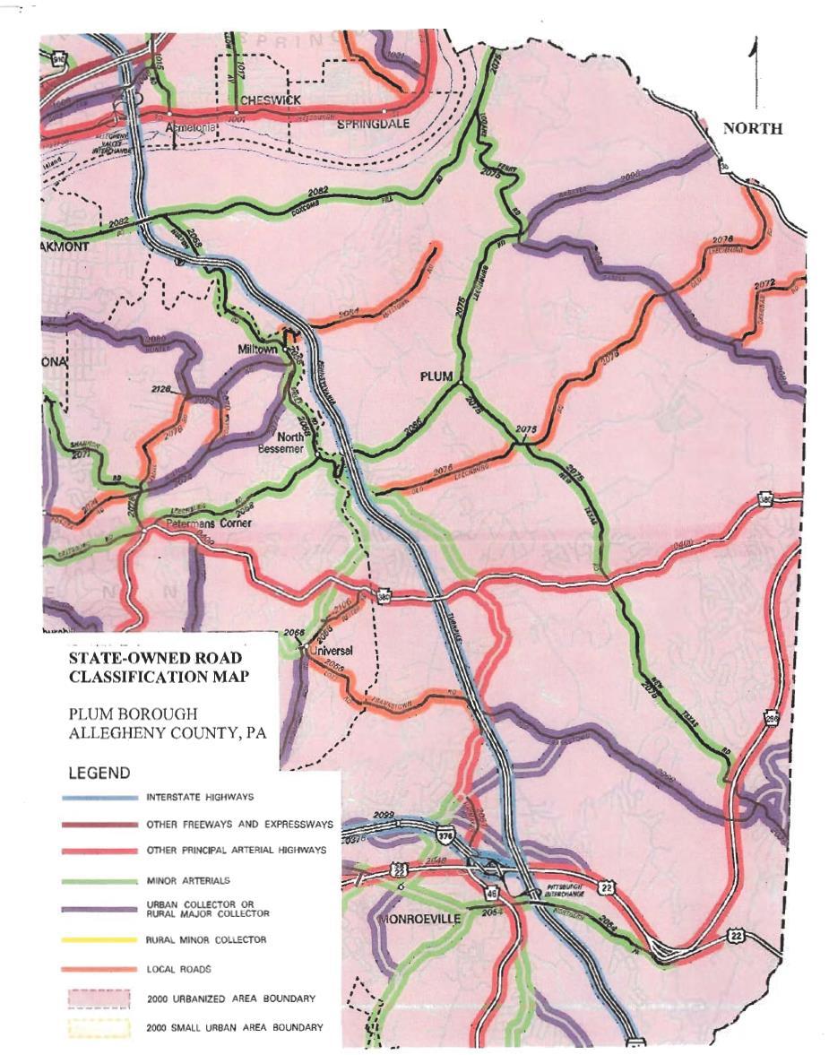
1 CHAPTER 5 TRANSPORTATION Introduction The movement of goods and people requires a transportation system of infrastructure and transit modes. Infrastructure includes roads, bridges, sidewalks, trails, railroads, airports, dams, etc., while modes of transit include motorized vehicles, planes, barges, trains, bicycles, walking, etc. Plum Borough s transportation system consists chiefly of a network of state and county roads and local streets. The other major elements of Plum Borough s transportation system are the Allegheny River and railroads. Infrastructure and Transit Modes Roads There are approximately 41 miles of state-owned roads within Plum Borough. The Pennsylvania Department of Transportation (PennDOT) classifies state-owned roads according to their function. Plum Borough has five types of state-owned roads---interstate, principal arterial, minor arterial, collector and local. (See State-Owned Road Classification Map.) PA Rte. 380 in the Center commercial district Source: Remington, Vernick & Beach Engineers Transportation 5-1
2 Transportation 5-2
3 The most recent (2007) Average Daily Traffic (ADT) counts available for state-owned roads in Plum Borough are as follows: Road Classification ADT PA Turnpike (I-76) Interstate 47,000 Monroeville-Trestle Road Principal Arterial NA PA Route 380 (west of New Texas ) Principal Arterial 12,000 PA Route 380 (east of New Texas ) Principal Arterial 4,800 PA Route 286 (south of New Texas ) Principal Arterial 20,000 PA Route 286 (north of New Texas ) Principal Arterial 19,000 PA Route 366 Principal Arterial 8,700 Hulton Road (west of PA Turnpike) Minor Arterial 18,000 Hulton Road (south of Coxcomb Hill ) Minor Arterial 5,600 Coxcomb Hill Road (between Hulton and Logans Ferry ) Minor Arterial 11,000 Coxcomb Hill Road (north of Logans Ferry ) Minor Arterial 13,000 Logans Ferry Road Minor Arterial 900 Leechburg Road (north of New Texas ) Minor Arterial 5,900 Leechburg Road (south of New Texas ) Minor Arterial 4,100 New Texas Road (between Leechburg and Old Leechburg ) Minor Arterial 5,900 New Texas Road (btw. Old Leechburg and PA Rte. 380) Minor Arterial 6,600 New Texas Road (between PA Rte. 380 and PA Rte. 286) Minor Arterial 5,300 Unity Center Road Minor Arterial NA Webster Road Collector 350 Sardis Road (btw. Leechburg and Old Leechburg ) Collector 850 Sardis Road (btw. Old Leechburg and Drennen ) Collector 1,200 Sardis Road (south of Drennen ) Collector 900 Old Frankstown Road (west of PA Rte. 286) Collector 6,600 Old Frankstown Road (east of PA Rte. 286) Collector 6,900 New Texas Road (btw. PA Rte. 286 and Sagamore Hill ) Collector 6,600 Frankstown -New Texas (east of Sagamore Hill ) Collector 7,100 Logans Ferry Road (north of Frankstown -New Texas ) Collector NA Old Frankstown Road (west of PA Turnpike) Local 3,000 Milltown Road Local 2,400 Old Leechburg Road (btw. PA Turnpike and New Texas ) Local 4,100 Old Leechburg Road (btw. New Texas and Sardis ) Local 2,200 Old Leechburg Road (btw. Sardis and PA Rte. 380) Local 1,500 Drennen Road Local 150 Source: PennDOT There are approximately 7.5 miles of county-owned roads in Plum Borough. The most recent Average Daily Traffic (ADT) counts available for county-owned roads in Plum Borough are as follows: Transportation 5-3
4 Road Classification ADT (date of count) Lindsey Lane Local 4,513 (11/11/04) Monroeville-Trestle Road Other Principal Arterial 20,240 (11/10/04) Pierson Run Road Local 3,422 (11/11/04) Renton Road Local 2,462 (4/11/05) Spring Miller Road Local 1,301 (11/10/04) Unity-Center Road Minor Arterial 11,525 (11/10/04) Source: Allegheny County Department of Public Works All public roads in the borough that are not state or county roads are owned and maintained by Plum Borough. Truck Routes There are numerous roadways that serve as truck corridors through Plum Borough. These roads include Old Frankstown Road, Monroeville-Trestle Road, PA Route 380, PA Route 286, Hulton Road, Coxcomb Hill Road, New Texas Road, Unity Center Road, Leechburg Road, Old Leechburg Road, and Sardis Road. While these roads are not officially designated as truck routes, they carry much of the heavy truck traffic through the borough to the PA Turnpike (I-76), I-376 and other roads. High-Accident Intersections According to the Plum Borough police department, the following intersections in the borough experience a high number of motor vehicle accidents: Monroeville-Trestle Road and PA Route 380 New Texas Road and PA Route 380 New Texas Road and PA Route 286 New Texas Road and Old Leechburg Road New Texas Road and Leechburg Road New Texas Road and Center-New Texas Road Coxcomb Hill Road and Hulton Road Roadway Sufficiency Analysis and Transportation Capital Improvements Plan In 2007, Plum Borough adopted both a roadway sufficiency analysis and a transportation capital improvements plan. These documents are incorporated into this comprehensive plan by reference. The purpose of the roadway sufficiency analysis was to determine existing and forecasted deficiencies in the borough s road network and to identify measures needed to address these deficiencies. The purpose of the transportation capital improvements plan was to establish the cost, timetable and budget for implementing the needed road network improvements. Transportation 5-4
5 The preparation of the roadway sufficiency analysis and the transportation capital improvements plan were prerequisites to the borough s establishment of transportation impact fees. These fees are imposed on developers to pay the cost of road improvements necessitated by the additional traffic generated by new commercial and residential development. To satisfy the requirements of the PA Municipalities Planning Code regarding the establishment of traffic impact fees, Plum Borough was divided into two Transportation Service Areas (TSA). TSAs are areas that contain an aggregation of sites that have development potential, thereby creating the need for transportation improvements to be funded with traffic impact fees. The boundary between the borough s two TSAs is defined by Leechburg Road, Ross Hollow Road, Old Leechburg Road, and Sardis Road. (See Transportation Service Areas Map on the following page.) The northern half of the borough is designated as TSA-N, and its impact fee is $934 per P.M. peak hour trip. (Peak hour is defined as the four consecutive highest volume 15- minute periods.) The remainder of the borough is designated as the TSA-S, and its impact fee is $1,485 per P.M. peak hour trip. The following is a summary of the roadway sufficiency analysis and the transportation capital improvements plan Existing Traffic Conditions The roadway sufficiency analysis studied 39 intersections in Plum Borough in terms of their capacities (levels of service), turning movement counts, and signalization status. The study also included recording average daily traffic volumes (ADTs) at 12 locations within the borough. The study s findings, conclusions, and recommendations were as follows: 1. The borough selected Level of Service (LOS) E as the preferred LOS for intersections. Level of Service E represents operating conditions at or near capacity levels. 2. Ten unsignalized intersections are operating below LOS E during one or both peak traffic hours, and nine of these intersections have peak hour traffic volumes that warrant signalization. Recommended mitigation measures include Installing traffic signals at eight of the nine intersections; Constructing turning lanes at three intersections; Realigning one road; and Restricting left turns at the intersection that is not recommended for signalization. The table on p. 5-7 lists the intersections, potential mitigation measures and resulting levels of service. 3. No transportation improvements were developed for the intersection of Leechburg Road with Elicker Road. This intersection is immediately adjacent to Plum Senior High School and only operates below LOS E during the A.M. peak hour, when students/faculty are arriving for school. This intersection would not warrant the installation of traffic signals during non-school months. Transportation 5-5
6 Transportation 5-6
7 2005 EXISTING CONDITIONS POTENTIAL MITIGATION AND RESULTING LEVELS OF SERVICE (LOS) MAP NO. * PROJECT NO. INTERSECTION 3 S-1 S.R and New Texas 9 S-2 S.R and Unity Center 15 S-3 Old Frankstown and Lindsey Lane/Hochberg 20 S-4 New Texas and Center New Texas 23 NS-1 New Texas and Leechburg 24A S-5 New Texas and Old Leechburg (eastern intersection) 25 S-6 Unity Trestle and Leechburg 26 S-7 Unity Trestle and Old Leechburg 37 N-1 Coxcomb Hill and Kerr MITIGATION Install traffic signal Install traffic signal Realign Lindsey Lane opposite Hochberg Road, construct eastbound left turn lane on Old Frankstown Road, and install traffic signal Install traffic signal Install traffic signal Restrict left turns out from Old Leechburg Construct eastbound right turn lane on Leechburg Road and install traffic signal. Install traffic signal Construct westbound left turn lane on Coxcomb Hill and install traffic signal. MITIGATED PEAK HOUR LOS CONSTRUCTION YEAR ESTIMATED COST A.M. P.M. B B ,450 B B ,887 1 B C ,208,589 C C ,229,825 D B ,652 2 D D ,321,597 3 B B ,357 B C ,478,349 4 C C ,100 5 Source: Analysis by Trans Associates. * Map numbers correspond to intersection numbers on Transportation Projects Location Map on p Includes construction of a left turn lane on Unity Center (See Project No. S-15.) 2. Includes construction of a westbound left turn lane on New Texas (See Project No. NS-2.) 3. Includes construction of a westbound left turn lane on Old Leechburg (see Project No. S-18) and construction of an eastbound right turn lane on New Texas (See project No. S-29.) 4. Includes construction of eastbound left turn lane on Unity Trestle (See Project No. S-31.) 5. Includes construction of northbound right turn lane on Kerr (See Project No. N-13.) Transportation 5-7

8 Transportation 5-8
9 2026 Projected Traffic Conditions Based on traffic projections for the year 2026, the Roadway Sufficiency Analysis determined that traffic volumes in 2026 would necessitate the following mitigation measures (assuming the mitigation measures to address 2005 existing condition deficiencies had been undertaken): 1. To handle base traffic volumes, six unsignalized intersections operating below LOS E during one or both peak traffic hours will warrant signalization, and five of these intersections will also warrant left turn lanes. The table below lists the intersections, potential mitigation measures and resulting levels of service. (See Transportation Projects Location Map on p. 5-8 to locate intersections by the map numbers listed in the table below.) 2026 BASE CONDITIONS POTENTIAL MITIGATION AND RESULTING LEVELS OF SERVICE (LOS) MAP NO. * PROJECT NO. INTERSECTION 5 S-8 S.R and Millers Lane 6 S-9 S.R and Davidson Road 11 N-2 S.R and Webster 12 N-3 S.R and Old Leechburg Road 13 S-10 Old Frankstown and Davidson 18 S-11 New Texas and O Block Source: Analysis by Trans Associates. MITIGATION Construct eastbound left turn lane on S.R and install traffic signal. Construct westbound left turn lane on S.R and install traffic signal. Construct northbound left turn lane on S.R and install traffic signal. Construct eastbound and westbound left turn lanes on S.R and install traffic signal. Install traffic signal. Construct eastbound left turn lane on New Texas and install traffic signal. MITIGATED PEAK HOUR LOS CONSTRUCTION YEAR A.M. P.M. B C ,265,176 A B ,099,038 1 A A ,936 A B ,301 C B ,218 2 C B ,766,257 ESTIMATED COST 1. Includes construction of northbound right turn lane on Davidson (See Project No. S-21.) 2. Includes construction of southbound right turn lane on Davidson (See Project No. S-23.) 2. Assuming that mitigation measures required to address 2026 base traffic volumes are implemented, the following mitigation measures will be required to accommodate pass-through traffic: Transportation 5-9
10 Eight unsignalized intersections operating below LOS E during one or both peak traffic hours will warrant traffic signalization and left turn lanes; Two intersections will require restrictions on left turns; and One intersection will require a channelized right turn lane. The table below lists intersections, potential mitigation measures and resulting levels of service. (See Transportation Projects Location Map on p. 5-8 to locate intersections by the map numbers listed in the table below.) 2026 PASS-THROUGH CONDITIONS POTENTIAL MITIGATION AND RESULTING LEVELS OF SERVICE (LOS) MAP NO. PROJECT NO. INTERSECTION 1 S-12 S.R and Abers Creek 7 S-13 S.R and Monroeville Trestle 8 S-14 S.R and Pierson Run 9 S-15 S.R and Unity Center 16 S-16 New Texas and Sagamore Hill /Old Frankstown 20 S-17 New Texas and Center New Texas 23 NS-2 New Texas and Leechburg 24A S-18 New Texas and Old Leechburg (eastern intersection) 24B S-19 New Texas and Old Leechburg (western intersection) 28 N-4 Leechburg and Shearer 29 N-5 Leechburg and Elicker (Near High School) 33 N-6 Milltown and Shearer /Kerr 38 N-7 Coxcomb Hill and Logan Ferry 39 N-8 Coxcomb Hill and Entrance Dr. Source: Analysis by Trans Associates. MITIGATION MITIGATED PEAK HOUR LOS CONSTRUCTION YEAR A.M. P.M. Install traffic signal. B B ,278 ESTIMATED COST Construct a channelized right turn lane on Monroeville Trestle Road. E D ,666 Restrict left turns westbound on E D ,742 Pierson Run Construct a westbound left turn D B 2013 Inc. in Project No. S-2 lane on Unity Center Install traffic signal. D E ,582 1 Construct a westbound left turn lane on New Texas E D 2012 Inc. in Project No. S-4 Construct a westbound left turn lane on New Texas C B 2009 Inc. in Project No. NS-1 Construct a westbound left turn E D 2025 Inc. in Project No. S-5 lane on Old Leechburg, and install a traffic signal. Construct a westbound left turn E C ,345,319 2 lane on New Texas, and install a traffic signal. Install a traffic signal. D C ,387,818 3 Construct northbound left turn lane on Leechburg Road and install a traffic signal. Construct a southbound left turn lane on Kerr and install traffic signal. Restrict left turns on Logan Ferry Construct a southbound left turn lane on Coxcomb Hill and install a traffic signal. E B ,181,093 4 E C ,889,518 5 B C ,436 B C ,057, Includes construction of northbound right turn lane on Old Frankstown (See Project No. S-25.) 2. Includes construction of northbound right turn lane on Old Leechburg (See Project No. S-30.) 3. Includes construction of northbound left turn lane on Leechburg (See Project No. N-9.) 4. Includes construction of eastbound left turn lane on Elicker (See Project No. N-10.) 5. Includes construction of westbound left turn lane on Shearer (See Project No. N-11.) 6. Includes construction of westbound left turn lane on Entrance Dr. (See Project No. N-14.) Transportation 5-10
11 MAP NO. PROJECT NO. 3. Assuming that mitigation measures needed to address 2026 base and pass-through traffic are implemented, the following mitigation measures will be required to accommodate traffic generated by new development: Five intersections operating below LOS E during one or both peak traffic hours will warrant traffic signalization; Eleven intersections will require left turn lanes; Six intersections will require right turn lanes; and One intersection will need restrictions on left turns. The table below lists intersections, potential mitigation measures and resulting levels of service. (See Transportation Projects Location Map on p. 5-8 to locate intersections by the map numbers listed in the table below.) 2026 NEW DEVELOPMENT CONDITIONS POTENTIAL MITIGATION AND RESULTING LEVELS OF SERVICE (LOS) INTERSECTION MITIGATION 2 S-20 S.R and O Block Construct a westbound left turn lane on S.R and install a traffic signal. 6 S-21 S.R and Davidson Construct a northbound right turn lane on Davidson S.R and Pierson Run NO ADDITIONAL MITIGATION POSSIBLE DUE TO GEOMETRIC DESIGN LIMITATIONS 10 S-22 S.R and Center New Texas Construct an eastbound left turn lane on S.R and install a traffic signal. 13 S-23 Old Frankstown and Davidson Construct a southbound right turn lane on Davidson 14 S-24 Old Frankstown and Pierson Run Construct an eastbound left turn lane on Old Frankstown and install a traffic signal. 16 S-25 New Texas Rd and Sagamore Hill Construct a northbound right turn lane / Frankstown on Old Frankstown MITIGATED PEAK HOUR LOS CONSTRUCTION YEAR ESTIMATED COST A.M. P.M. B A ,797 D E 2027 Inc. in project S-9 F F E C ,507 E C 2016 Inc. in Project No. S-10 B B ,334,065 D D 2011 Inc. in Project No. S S-26 New Texas and Lindsey Lane Install traffic signal B C , S-27 New Texas and Center New Texas Construct a northbound left turn lane on Center-New Texas 21 S-28 New Texas and Renton Construct an eastbound left turn lane on New Texas and install a traffic signal. 24A S-29 New Texas and Old Leechburg (eastern intersection) Construct an eastbound right turn lane on New Texas 24B S-30 New Texas and Old Leechburg Construct a northbound right turn lane (western intersection) on Old Leechburg 26 S-31 Old Leechburg and Unity Trestle Construct an eastbound left turn lane on Unity Trestle 28 N-9 Leechburg and Shearer Construct a northbound left turn lane on Leechburg. 29 N-10 Leechburg and Elicker (Near Construct a eastbound left turn lane on High School) Elicker 33 N-11 Milltown and Shearer / Kerr Construct a westbound left turn lane on Shearer 36 N-12 Coxcomb Hill and Repp Construct a westbound left turn lane on Coxcomb Hill and restrict left turns out of Repp 37 N-13 Coxcomb Hill and Kerr Construct a northbound right turn lane on Kerr 39 N-14 Coxcomb Hill and Entrance Dr. Construct westbound left turn lane on Entrance Dr. Source: Analysis by Trans Associates. D D 2017 Inc. in Project No. S-4 D C ,239,654 E D 2025 Inc. in Project No. S-5 E D 2025 Inc. in Project No. S-19 C E 2015 Inc. in Project No. S-7 E D 2017 Inc. in Project No. N-4 D B 2021 Inc. in Project No. N-5 E B 2016 Inc. in Project No. N-6 B D ,611 E E 2009 Inc. in Project No. N-1 E D 2010 Inc. in Project No. N-8 Transportation 5-11
12 Implementation of mitigation measures in the proposed construction years listed in the above tables is contingent upon the availability of funding from private sector and public sector sources. Costs are inflation-adjusted to the year of proposed construction. The total cost of all mitigation measures is approximately $43.2 million, including $9.9 million from impact fees for mitigation measures attributable to new development. Bicycle and Pedestrian Trails With the exception of the trails in Boyce Park, there are no bicycle or pedestrian trails in Plum Borough. One of the transportation improvements proposed in this comprehensive plan is the creation of pedestrian and bicycle linkages within and between existing and planned developments and community facilities/features. (See Goal 2, Objective A on page 5-18.) Also, the borough s forthcoming parks, recreation and open space plan will address the possibility and location of bicycle and pedestrian trails. Allegheny River The Allegheny River forms Plum Borough s northwestern border and provides opportunities for both recreational and commercial uses. Although there are a number of private marinas along Plum s river frontage, no businesses in the borough are using the river for commercial transportation. The only river transportation facility in the borough is the U. S. Army Corps of Engineers CW Bill Young Lock and Dam No. 3. Built in 1934, the lock and dam are located in the northwestern corner of the borough. The Corps of Engineers does not plan any major rehabilitation of this facility in the next five to 10 years, but scheduled maintenance on the lock and dam will occur in June Railroads There are two railway corridors in Plum Borough. The Allegheny Valley Railroad has tracks along the Allegheny River and runs one freight trip daily between the City of Arnold in Westmoreland County and the Strip District in the City of Pittsburgh. The Bessemer and Lake Erie Railroad has a line that parallels the northern portion of the PA Turnpike as it traverses the borough. This spur terminates in a railyard in Penn Hills Township to the west of Plum Borough. Currently, there is no passenger rail service in or through Plum Borough. However, in 2008, the Westmoreland County Transit Authority undertook a preliminary study to investigate the feasibility of establishing commuter rail service on the Allegheny Valley Railroad line between Pittsburgh and the City of Arnold in Westmoreland County. The alternatives recommended in this study did not include a stop in Plum Borough, but the study called for additional, more detailed analysis of the proposed commuter rail service. This proposed commuter rail service is one of only two transportation projects proposed for Plum Borough that is included in Allegheny County s Comprehensive Plan. (See Proposed Transportation Projects Map on page 5-14.) Transportation 5-12

13 Allegheny Valley Railroad tracks along the Allegheny River Trail in Barking. Source: Remington, Vernick & Beach Engineers Transportation 5-13
14 Transportation 5-14

15 Airports There are no airports in Plum Borough. The closest airport to the borough is Pittsburgh- Monroeville Airport, which is a general aviation airport less than one mile south of the southwestern corner of the borough. The region s major airport, Greater Pittsburgh International Airport, is about 30 miles west of the borough and is accessed via I-376, I-279 and US Route 60. Allegheny County Airport, a business service airport, is 15 miles southwest of the borough and is accessed via a combination of state and county roads. Park and Ride lot at the intersection of Coxcomb Hill and River Source: Remington, Vernick & Beach Engineers Public Transit Transportation networks include both private and public transit modes. Most Plum Borough residents use private automobiles for their daily transportation needs, but the Port Authority of Allegheny County (PAT) provides public transit via three bus routes that serve the southwestern and southeastern corners of the borough. PAT has a 110-space Park and Ride lot on Rt. 286 in the Holiday Park (southeastern) section of the borough and a 25-space Park and Ride lot at the intersection of Coxcomb Hill Road and River Road. Transportation 5-15
16 PennDOT Transportation Improvement Plan PennDOT s 12-Year Transportation Improvement Plan (TIP) contains two projects in Plum Borough---the rehabilitation of the Plum Street Bridge and the remediation of the landslide area on Leechburg Road between New Texas Road and Elicker Road. Both of these projects are to be completed by September PennDOT has proposed to widen Route 286 from Route 22 in Monroeville, through Plum Borough to the Westmoreland County line. Phase 1 of this widening project (the segment of Route 286 in Monroeville) is currently in the design stage and is included in PennDOT s 12 Year TIP. Phase 2 of the project involves the segment of Route 286 from the Monroeville-Plum border to Presque Isle Drive in Plum Borough, and Phase 3 covers the segment from Presque Isle Drive to the Westmoreland County line. Some preliminary design/concept work has been completed for Phases 2 and 3, but a lack of funding has halted all further engineering work on these phases and their construction is unlikely in the near future. Transportation Plan Virtually all of the existing and projected deficiencies identified in Plum Borough s 2007 roadway sufficiency analysis are located on state-owned and county-owned roads. The borough cannot correct these deficiencies without both the cooperation and resources of the Commonwealth of Pennsylvania, Allegheny County and the private sector. In like manner, the borough must collaborate with state, county and regional partners to address major transportation needs and issues, e.g., the widening of Rt. 286, public transit routes and facilities, and commuter rail service. However, there are some unilateral actions Plum Borough can take to improve the borough s transportation network and help achieve other transportation goals. Some of these actions include: Adopting a pavement management system to provide well-maintained streets. Amending land use regulations and other borough ordinances to require sidewalks and/or walking and biking trails in new developments, thereby promoting alternate transportation modes. Promoting dense mixed use development that reduces the need for automobiles for daily activities. Promoting alternative modes of transportation and healthier lifestyles by installing bicycle racks at public buildings and facilities. The following goals, objectives and strategies will help Plum Borough meet its transportation needs: Goal 1: Provide an efficient transportation network for the circulation and movement of goods and people through the borough Objective A: Maintain a safe and efficient road system. Strategy: Transportation 5-16
17 Adopt a pavement management system to insure a well-maintained road system. Work with PennDOT and Allegheny County to develop and implement safety improvements, including traffic-calming measures, for roads with high accident rates. Consider implementing traffic-calming measures where needed in existing residential areas that are impacted by new commercial development. Maintain liaisons with PennDOT and Allegheny County to identify and implement needed improvements and upgrades to state-owned and countyowned roads and bridges in the borough. Solicit the assistance of state and county legislators to secure the funding needed to implement improvements and upgrades to state-owned and county-owned roads in Plum, including the widening of Route 286 through the borough and addressing existing road network deficiencies that were identified in the borough s 2006 transportation capital improvements plan. The widening of Route 286 should incorporate lighting features and landscaping, i.e., the planting of trees along both sides of the road to beautify this commercial development area. Through zoning and land development regulations, promote clustered commercial development with limited curb cuts and connecting service roads. Solicit PennDOT to periodically re-time and coordinate traffic signals on state-owned roads to provide optimum traffic flow and to reduce traffic congestion, travel times and fuel consumption. Support improvements that reduce/minimize pedestrian/vehicular conflicts. Amend the borough s Unified Development Ordinance to: Incorporate sidewalk construction design standards. Objective B: Coordinate land development and transportation improvements as identified in the borough s 2006 transportation capital improvements plan. Strategy: Solicit the cooperation and resources of PennDOT, Allegheny County and the private sector (via traffic impact fees) to implement the improvements Transportation 5-17
18 needed to address the existing and projected deficiencies identified in the 2007 roadway sufficiency analysis. Objective C: Amend the borough s Unified Development Ordinance regulations concerning off street parking. Strategy: Require interior landscaping in parking lots that have 50 or more parking spaces, with landscaped islands required at the end of parking rows and within parking rows that contain more than 20 spaces. Increase the minimum size of an off-street parking space to 9 x20 Where feasible, permit paving methods that are partially pervious to reduce the amount of impervious pavement in the borough. Goal 2: Promote alternate methods of transportation and a multi-modal transportation network Objective A: Create pedestrian and bicycle linkages within and between existing and planned developments and community facilities/features. Strategy: Develop walking and bicycling trails by amending the Borough s unified development ordinance to require sidewalks, trails and paths in new residential developments and sidewalks in commercial developments. Evaluate the feasibility and potential location of walking and biking trails in the forthcoming borough parks, recreation and open space plan. Promote dense mixed-use development that reduces the need for automobiles for daily activities. Work with PennDOT and Allegheny County to identify roads that are suitable for bicycling and install appropriate signage, e.g., Share the Road signs. Work with PennDOT and Allegheny County to provide bicycle/pedestrian facilities (including sidewalks or paved berms with bicycle/pedestrian lane markings) as part of improvements to rights-of way, e.g., the widening of Route 286. Require bicycle racks in large scale commercial developments. Install bicycle racks at all public buildings and facilities. Transportation 5-18
19 Objective B: Encourage the use of public transportation. Strategy: Solicit the Port Authority of Allegheny County to develop additional (or enlarge existing) Park n Ride lots in Plum. Request that the Port Authority of Allegheny County install bicycle racks at Park and Ride lots. Objective C: Support efforts to establish commuter rail traffic through Plum Borough. Strategy: Maintain liaison with the Westmoreland County Transit Authority and other parties that are studying the feasibility of establishing commuter rail service through Plum Borough. Seek support of local legislators to secure a stop in Plum if commuter rail service is established on the Allegheny Valley Railroad line. Objective D: Work with Allegheny County and other regional trail-building organizations to implement the proposed segment of the Allegheny County Regional Trail System that runs along the borough s Allegheny River frontage. Objective E: Improve access to the Allegheny River in conjunction with efforts to develop or redevelop the riverfront for commercial, mixed use or recreational uses. Strategy: If warranted, widen and/or improve Barking Road Encourage private development (and consider public development) that provides riverwalks, off-street parking, fishing piers, boat launches, riverfront parks, etc. Transportation 5-19
CITY OF COCOA BEACH 2025 COMPREHENSIVE PLAN. Section VIII Mobility Element Goals, Objectives, and Policies
 CITY OF COCOA BEACH 2025 COMPREHENSIVE PLAN Section VIII Mobility Element Goals, Objectives, and Policies Adopted August 6, 2015 by Ordinance No. 1591 VIII MOBILITY ELEMENT Table of Contents Page Number
Clackamas County Comprehensive Plan
 ROADWAYS The County s road system permits the movement of goods and people between communities and regions, using any of a variety of modes of travel. Roads provide access to virtually all property. They
Circulation in Elk Grove includes: Motor vehicles, including cars and trucks
 Circulation, as it is used in this General Plan, refers to the many ways people and goods move from place to place in Elk Grove and the region. Circulation in Elk Grove includes: Motor vehicles, including
INTERMODAL TRANSPORTATION PLAN
 INTRODUCTION INTERMODAL TRANSPORTATION PLAN Effective intermodal transportation implies a public policy for actively decreasing the demand for automobile trips and consequently reducing automobile related
4. ENVIRONMENTAL IMPACT ANALYSIS 9. TRANSPORTATION AND TRAFFIC
 4. ENVIRONMENTAL IMPACT ANALYSIS 9. TRANSPORTATION AND TRAFFIC 4.9.1 INTRODUCTION The following section addresses the Proposed Project s impact on transportation and traffic based on the Traffic Study
TRASBURG RANSPORTATION
 TRASBURG RANSPORTATION LAN DEVELOPED BY THE TRANSPORTATION PLANNING DIVISION OF THE VIRGINIA DEPARTMENT OF TRANSPORTATION IN COOPERATION WITH THE U.S. DEPARTMENT OF TRANSPORTATION, FEDERAL HIGHWAY ADMINISTRATION
Solana Beach Comprehensive Active Transportation Strategy (CATS)
") Solana Beach Comprehensive Active Transportation Strategy (CATS) 3.0 Goals & Policies The Solana Beach CATS goals and objectives outlined below were largely drawn from the Solana Beach Circulation Element
Solana Beach Comprehensive Active Transportation Strategy (CATS) 3.0 Goals & Policies The Solana Beach CATS goals and objectives outlined below were largely drawn from the Solana Beach Circulation Element
Route 7 Corridor Study
 Route 7 Corridor Study Executive Summary Study Area The following report analyzes a segment of the Virginia State Route 7 corridor. The corridor study area, spanning over 5 miles in length, is a multi
o n - m o t o r i z e d transportation is an overlooked element that can greatly enhance the overall quality of life for the community s residents.
 N o n - m o t o r i z e d transportation is an overlooked element that can greatly enhance the overall quality of life for the community s residents. 84 Transportation CHAPTER 11 INTRODUCTION Transportation
Basalt Creek Transportation Refinement Plan Recommendations
 Basalt Creek Transportation Refinement Plan Recommendations Introduction The Basalt Creek transportation planning effort analyzed future transportation conditions and evaluated alternative strategies for
ARTINSVILLE ENRY OUNTY REA RANSPORTATION TUDY
 ARTINSVILLE ENRY OUNTY REA RANSPORTATION TUDY DEVELOPED BY THE TRANSPORTATION AND MOBILITY PLANNING DIVISION OF THE VIRGINIA DEPARTMENT OF TRANSPORTATION IN COOPERATION WITH THE U.S. DEPARTMENT OF TRANSPORTATION,
DRAFT BUENA VISTA 2020 TRANSPORTATION PLAN
 DRAFT BUENA VISTA 2020 TRANSPORTATION PLAN DEVELOPED BY THE TRANSPORTATION PLANNING DIVISION OF THE VIRGINIA DEPARTMENT OF TRANSPORTATION IN COOPERATION WITH THE U.S. DEPARTMENT OF TRANSPORTATION, FEDERAL
Improving Cyclist Safety at the Dundas Street West and Sterling Road Intersection
 STAFF REPORT ACTION REQUIRED Improving Cyclist Safety at the Dundas Street West and Sterling Road Intersection Date: August 17, 2012 To: From: Wards: Reference Number: Public Works and Infrastructure Committee
O HARA TOWNSHIP. O Hara Township Trail Feasibility and Planning Project, prepared by PBS&J TriLine, April 2005.
 Township of O Hara O HARA TOWNSHIP Chapter 7 - Transportation and Circulation OVERVIEW The transportation network in O Hara Township evolved from access to two (2) regional arterials, PA 28 and SR 1001,
Item to be Addressed Checklist Consideration YES NO N/A Required Description Complete Streets Guidelines
 Passaic County Complete Streets Checklist - Concept Development Project Name Item to be Addressed Checklist Consideration YES NO N/A Required Description Complete Streets Guidelines Existing Plans Have
ARRENTON RANSPORTATION
 ARRENTON RANSPORTATION LAN DEVELOPED BY THE TRANSPORTATION PLANNING DIVISION OF THE VIRGINIA DEPARTMENT OF TRANSPORTATION IN COOPERATION WITH THE U.S. DEPARTMENT OF TRANSPORTATION, FEDERAL HIGHWAY ADMINISTRATION
Multi Modal Transit Access Plan KIPDA ID # 239. Project Type: STUDY
 Multi Modal Transit Access Plan KIPDA ID # 239 Project Type: STUDY Description: In conjunction with the results from Project Gobility and the Transit LOS Analysis, TARC seeks to examine the possibilities
Town of Bethlehem. Planning Assessment. Bethlehem Town Board
 Town of Bethlehem US 9W Corridor Transportation Planning Assessment Presented e to: Bethlehem Town Board June 2009 Overview Study Background Route 9W Corridor Conditions and Improvements Selkirk Bypass
Exhibit 1 PLANNING COMMISSION AGENDA ITEM
 Exhibit 1 PLANNING COMMISSION AGENDA ITEM Project Name: Grand Junction Circulation Plan Grand Junction Complete Streets Policy Applicant: City of Grand Junction Representative: David Thornton Address:
Chapter 5 Future Transportation
 Chapter 5 Future Transportation The Future Land Use Plan identifies the desired land use designations. The land uses desired for Crozet depend, in large part, on the success of the transportation system,
C C C
 C-012-001 Thank you for your support for the creation of new public space and nonmotorized access between downtown and the waterfront through the Overlook Walk, the East-West Connections, and the Promenade.
TRAFFIC IMPACT ANALYSIS
 TRAFFIC IMPACT ANALYSIS FOR THE CHAMPAIGN UNIT#4 SCHOOL DISTRICT PROPOSED HIGH SCHOOL (SPALDING PARK SITE) IN THE CITY OF CHAMPAIGN Final Report Champaign Urbana Urbanized Area Transportation Study 6/24/2014
APPENDIX G: INTERSECTION NEEDS AT OKEECHOBEE BOULEVARD
 APPENDIX G: INTERSECTION NEEDS AT OKEECHOBEE BOULEVARD INTERSECTION NEEDS AT SR 7 and OKEECHOBEE BOULEVARD SR 7 Extension Project Development and Environment (PD&E) Study From Okeechobee Boulevard (SR
INTRODUCTION THOROUGHFARE SYSTEM CLASSIFICATIONS
 INTRODUCTION The thoroughfare plan will assist public officials in the development of a specialized system for efficient and safe movement of vehicular traffic while minimizing potential conflicts with
SECTION 1 - TRAFFIC PLANNING
 SECTION 1 - TRAFFIC PLANNING 1.1 TRAFFIC OPERATIONS 1.1.1 Roadway Functional Classification The Multnomah County Comprehensive Framework Plan s Policy 34: Trafficways and the Functional Classification
FAYETTE COUNTY. Fayette County Active Transportation Profile REGIONAL ACTIVE TRANSPORTATION PLAN FOR SOUTHWESTERN PENNSYLVANIA
 REGIONAL ACTIVE TRANSPORTATION PLAN FOR SOUTHWESTERN PENNSYLVANIA 1 2 ACTIVE TRANSPORTATION AT A GLANCE Trails + Bike Routes 4 miles 73 miles 130 miles 90 miles Parkland Parkland Trail Off Street Trail
City of Bartow Comprehensive Plan. Transportation Element
 City of Bartow 2030 Comprehensive Plan Amended through January 7, 2013 TRANSPORTATION ELEMENT GOAL: IT SHALL BE A GOAL OF THE CITY OF BARTOW TO PROVIDE A SAFE AND EFFICIENT MULTI-MODAL TRANSPORTATION SYSTEM
SR-203 Sidewalks and Town-Wide Mobility Improvements. Town Council Presentation September 7, 2016
 SR-203 Sidewalks and Town-Wide Mobility Improvements Town Council Presentation September 7, 2016 SR-203 Sidewalks and Town- Wide Mobility Improvements SR-203 Sidewalks and Appurtenances Town-Wide Mobility
Borough of Danville, PA Traffic Calming Program Guidelines
 Borough of Danville, PA Traffic Calming Program Guidelines Adopted by Borough Council on 1 INTRODUCTION Speeding Traffic is a major concern in the Borough of Danville because of its detrimental impacts
Board of Supervisors February 27, 2017
 : Traffic Analysis Results & Draft Conceptual Plan Board of Supervisors February 27, 2017 Transportation Solutions Building Better Communities Presentation Overview Background Summary of Traffic Analysis
NM-POLICY 1: Improve service levels, participation, and options for non-motorized transportation modes throughout the County.
 Transportation PRINCE WILLIAM COUNTY 2008 COMPREHENSIVE PLAN NON-MOTORIZED PLAN CONTENTS Goals, Policies, and Action Strategies Table 4 (Bike Facility Classifications and Descriptions) Table 5 (Bike Facility
PennDOT Access Management Model Ordinances Training
 PennDOT Access s Training Trainers: Chad Dixson, AICP, TPD Angela Watson, PB Objective of Today Assist Pennsylvania s municipalities and transportation professionals in better understanding the benefits
GOAL 2A: ESTABLISH AND MAINTAIN A SAFE, CONVENIENT, AND EFFICIENT MULTI-MODAL TRANSPORTATION SYSTEM TO MOVE PEOPLE AND GOODS THROUGHOUT THE CITY.
 2. TRANSPORTATION ELEMENT The purpose of this element is to assist in establishing an adequate transportation system within the City and to plan for future motorized and non-motorized traffic circulation
5. RUNNINGWAY GUIDELINES
 5. RUNNINGWAY GUIDELINES These guidelines should be considered collectively when making runningway decisions. A runningway is the linear component of the transit system that forms the right-of-way reserved
City of Wilsonville 5 th Street to Kinsman Road Extension Project
 City of Wilsonville 5 th Street to Kinsman Road Walking Tour & Neighborhood Workshop Summary Report Public Outreach Overview On July 18 th, 2017, the City of Wilsonville hosted a neighborhood walking tour
MOUNTAIN HOUSE SPECIFIC PLAN I 9.1 INTRODUCTION ASSUMPTIONS TRANSPORTATION FACILITIES TRANSPORTATION IMPROVEMENTS PHASING 9.
 CHAPTER NINE: TRANSPORTATION AND CIRCULATION 9.1 INTRODUCTION 9.1 9.2 ASSUMPTIONS 9.1 9.3 TRANSPORTATION FACILITIES 9.1 9.4 TRANSPORTATION IMPROVEMENTS PHASING 9.3 LIST OF FIGURES LIST OF TABLES Figure
US Route 30 Master Plan Optimal Corridor Conceptual Plan
 Prepared for: Smart Growth Partnership of Westmoreland County Renaissance Planning Group Prepared by: Michael Baker Jr., Inc. Moon Township, PA March 13, 2007 Table of Contents Introduction... 1 Corridor
Giles Run Connector Road
 Giles Run Connector Road Laurel Hill Adaptive Reuse Area to Laurel Crest Drive South County Federation Meeting June 14, 2016 History Connector road included in the Laurel Hill Comprehensive Plan amendment
Duwamish Way-finding and CTR Report
 V. North Tukwila When the North Tukwila Manufacturing and Industrial Center was designated in 1992 as part of the region s land use and transportation plan, the plan called for the area to set a light-rail
Figure 1: East West Connector Alignment Alternatives Concept Drawing
 Page 2 of 9 Figure 1: East West Connector Alignment Alternatives Concept Drawing The Montebello Drive extension will run north south and connect Wilsonville Road to the Boones Ferry Road to Brown Road
Chapter 7. Transportation. Transportation Road Network Plan Transit Cyclists Pedestrians Multi-Use and Equestrian Trails
 Chapter 7 Transportation Transportation Road Network Plan Transit Cyclists Pedestrians Multi-Use and Equestrian Trails 7.1 TRANSPORTATION BACKGROUND The District of Maple Ridge faces a number of unique
3.0 PROJECT DESCRIPTION
 The following section of the Draft EIR contains a description of the proposed Elk Grove Boulevard/SR 99 Interchange Modification project, consistent with the requirements of CEQA Guidelines Section 15124.
Chapter 5. Complete Streets and Walkable Communities.
 Chapter 5. Complete Streets and Walkable Communities. 5.1 Description of Complete Streets. Cities throughout the world, and specifically the United States, are coming to embrace a new transportation and
Corpus Christi Metropolitan Transportation Plan Fiscal Year Introduction:
 Introduction: The Safe, Accountable, Flexible, Efficient Transportation Equity Act: A Legacy for Users (SAFETEA-LU) has continued the efforts started through the Intermodal Surface Transportation Efficiency
DATE: October 20, Planning Commission. Beth McKibben, Planner Community Development Department FILE NO.: CSP
 DATE: October 20, 2014 TO: FROM: Planning Commission Beth McKibben, Planner Community Development Department FILE NO.: CSP2014 0017 PROPOSAL: Local consistency review of DOT&PF project to remove and replace
Executive Summary Route 30 Corridor Master Plan
 Route Corridor Master Plan Project Overview The Route Corridor Master Plan is a coordinated multimodal transportation and land use plan for the entire stretch of Route through East Whiteland Township,
APPENDIX D: Southwest Volusia Regional Transportation Study. Evaluation Criteria FINAL
 D: PROJECT PRIORITIZATION Prioritization of the improvements proposed in the Multimodal Improvement Plan is required in order to determine which projects should be funded first, where the transportation
Chapter 6 Transportation Plan
 Chapter 6 Transportation Plan Transportation Plan Introduction Chapter 6 Transportation Plan Transportation Plan Introduction This chapter describes the components of Arvada s transportation system, comprised
CITY OF SPOKANE VALLEY Request for Council Action
 CITY OF SPOKANE VALLEY Request for Council Action Meeting Date: December 16, 2014 Department Director Approval: Check all that apply: consent old business new business public hearing information admin.
Project Description Form 8EE
 Project Description Form 8EE Basic Project Information Submitting Jurisdiction/Agency: Town of Dumfries Project Title: Route 1 (Fraley Blvd) Widening: Brady's Hill Road to Dumfries Road Project Location:
Chapter 6: Transportation
 Chapter 6: Transportation I. INTRODUCTION The purpose of the Transportation Plan element of the Comprehensive Plan is to provide guidance to the City of North Mankato, as well as existing and future landowners
DRAFT - CITY OF MEDFORD TRANSPORTATION SYSTEM PLAN Roadway Cross-Sections
 Roadway Cross-Sections Medford s roadway cross-section standards apply to new and reconstructed roads. The crosssections take into consideration roadway function and operational characteristics, including
FY STATEWIDE TRANSPORTATION IMPROVEMENT PROGRAM New Jersey Department of Transportation Projects
 ROUTE/ Project ID No. TIP No. Electrical Load Center Replacement - North 04324 04324 This project will provide for the betterment of the existing highway lighting facilities located along Routes 3, 17
ALLEGHENY COUNTY. Allegheny County Active Transportation Profile 2017 REGIONAL ACTIVE TRANSPORTATION PLAN FOR SOUTHWESTERN PENNSYLVANIA
 REGIONAL ACTIVE TRANSPORTATION PLAN FOR SOUTHWESTERN PENNSYLVANIA 1 2 ACTIVE TRANSPORTATION AT A GLANCE Trails + Bike Routes 123miles 132 miles 281 miles 75 miles 3 FACILITIES Facility Metrics (not including
Bluffdale/ UDOT South High-T Intersection Project Type Operations
 Bluffdale/ UDOT 14600 South High-T Intersection Project Type Operations 14600 South and Redwood Road $ 600,000 $ 550,000 This project is to install a new High-T intersection at Redwood Road and 14600 South
Madison Urban Area and Dane County. Bicycle Transportation Plan Summary. September Introduction. Bicycle Plan Scope and Planning Process
 Bicycle Transportation Plan Summary Madison Urban Area and Dane County Introduction September 2000 Bicycling is an important mode of transportation in the Madison urban area and countywide that is available
ELEMENT 11 TRANSPORTATION ELEMENT
 ELEMENT 11 TRANSPORTATION ELEMENT TRANSIT, CIRCULATION, PARKING, PEDESTRIAN, & NON-VEHICULAR CIRCULATION Introduction The following narrative describes the concepts on which the transportation plan is
5 CIRCULATION AND STREET DESIGN
 5 CIRCULATION AND STREET DESIGN This chapter describes circulation and streetscape improvements proposed for the Northwest Chico Specific Plan Area. It includes detailed design specifications for existing
WELCOME. Thank you for joining us at the Second Public Workshop for the Carlsbad Pedestrian Master Plan. We look forward to receiving your feedback.
 City of Carlsbad Pedestrian Master Plan: WELCOME WELCOME Please Sign In Provide Input at Flip Charts Review Boards Presentation of Draft Plan Thank you for joining us at the Second Public Workshop for
CHAPTER 7 CIRCULATION
 CHAPTER 7 CIRCULATION A township s transportation network links its population with the surrounding communities. Transportation networks, including public and private, provide the means by which township
MCTC 2018 RTP SCS and Madera County RIFP Multi-Modal Project Eval Criteria GV13.xlsx
 MCTC 8 RTP SCS and Madera County RIFP Multi-Modal Project Eval Criteria GV.xlsx Madera County Transportation Commission Regional Transportation Plan / Sustainable Communities Strategy Multi-Modal Project
TRANSPORTATION ANALYSIS REPORT US Route 6 Huron, Erie County, Ohio
 TRANSPORTATION ANALYSIS REPORT US Route 6 Huron, Erie County, Ohio December 12, 2012 Prepared for: The City of Huron 417 Main Huron, OH 44839 Providing Practical Experience Technical Excellence and Client
Southwest Bus Rapid Transit (SW BRT) Functional Planning Study - Executive Summary January 19 LPT ATTACHMENT 2.
 Functional Planning Study - Executive Summary January 19 LPT ATTACHMENT 2.") Southwest Bus Rapid Transit (SW BRT) Functional Planning Study - Executive Summary 2011 January 19 1 of 19 Introduction This executive summary presents the results of the Southwest Bus Rapid Transit (SW
Southwest Bus Rapid Transit (SW BRT) Functional Planning Study - Executive Summary 2011 January 19 1 of 19 Introduction This executive summary presents the results of the Southwest Bus Rapid Transit (SW
TRANSPORTATION TRAINING TOPICS. April 6, 2010
 TRANSPORTATION TRAINING TOPICS April 6, 2010 Roles of Transportation Providers Context and Policy Makers Division of Transportation and Traffic Other City Operations Other Transportation Operators CMA
Phone: Fax: Project Reference No. (to be filled out by MassHighway):
:") Massachusetts Highway Department District 3 Project Need Form (PNF) This form is intended to provide preliminary information about the proposed project. It is not expected that all information that is
Massachusetts Highway Department District 3 Project Need Form (PNF) This form is intended to provide preliminary information about the proposed project. It is not expected that all information that is
VIII. Project Prioritization & Implementation
 Transportation Plan 2030 July 2006 VIII. Project Prioritization & Implementation Public Transit Service Investigation into the development of a demand responsive service route system through a process
West Dimond Blvd Upgrade Jodhpur Street to Sand Lake Road
 West Dimond Blvd Jodhpur St to Sand Lake CSS Transportation Project Summary Municipality of Anchorage Project # 05 005 Project Manager: John Smith, P.E. (MOA PM&E) Project Administrator: Julie Makela,
Highway 49, Highway 351 and Highway 91 Improvements Feasibility Study Craighead County
 Highway 49, Highway 351 and Highway 91 Improvements Feasibility Study Craighead County Executive Summary March 2015 Highway 49, Highway 351 and Highway 91 Improvements Feasibility Study Craighead County
TRAFFIC ASSESSMENT River Edge Colorado
 TRAFFIC ASSESSMENT River Edge Colorado Submitted by: Fehr & Peers 621 17th Street, Ste. 231 Denver, CO 8293 (33) 296-43 December, 21 App. M-2 Traffic Assessment River Edge Colorado December 21 TABLE OF
TRAFFIC ACTION PLAN. Laurie Meadows Neighborhood CITY OF SAN MATEO
 TRAFFIC ACTION PLAN Laurie Meadows Neighborhood CITY OF SAN MATEO Draft January 2017 Table of Contents Introduction... 2 The Traffic Forum Process... 5 Neighborhood Traffic Issues... 7 Neighborhood Recommendations
Terwillegar Drive Expressway Draft Concept Plan
 Terwillegar Drive Expressway Draft Concept Plan Anthony Henday Drive to Whitemud Drive November 28 5:00-8:00 p.m. December 1 10:00 a.m. - 3:00 p.m. Let s Talk Today you can: Learn about the new direction
FI-2 I-66 Between Route 29, Lee Highway and Route 15, James Madison Highway
 TRANSPORTATION PLAN INTENT Transportation is the key to the economic and social development of Prince William County and especially to the I 66/Route 29 Sector Plan area. This includes transportation for
RZC Appendix 8A Marymoor Subarea Street Requirements
 RZC Appendix 8A Marymoor Subarea Street Requirements For additional design details for Marymoor Subarea infrastructure, refer to the 2017 Marymoor Subarea Infrastructure Planning Report. STREET REQUIREMENTS
The Bike Buzz in Richland. November 2017 Carl Berkowitz
 The Bike Buzz in Richland November 2017 Carl Berkowitz Richland has been growing by leaps and bounds with lots of new homes and roads throughout the community. Recognizing all the growth in the Queensgate
ACTIVE TRANSPORTATION
 ACTIVE TRANSPORTATION Mobility 2040 Supported Goals Improve the availability of transportation options for people and goods. Support travel efficiency measures and system enhancements targeted at congestion
City of Gainesville Transportation/Roadway Needs PROJECT SUMMARY
 A1 Roadway Resurfacing $23,846,000 TYPE: Preservation of existing system Roadway resurfacing A2 Signal Replacement $6,000,000 TYPE: Preservation of existing system Replace traffic signals. B1 W 6th St
2. TRANSPORTATION ELEMENT.
 2. TRANSPORTATION ELEMENT. The purpose of this element is to assist in establishing an adequate transportation system within the City and to plan for future motorized and non-motorized traffic circulation
RESOLUTION NO ?? A RESOLUTION OF THE CITY OF NEPTUNE BEACH ADOPTING A COMPLETE STREETS POLICY
 RESOLUTION NO. 2018-?? A RESOLUTION OF THE CITY OF NEPTUNE BEACH ADOPTING A COMPLETE STREETS POLICY WHEREAS, safe, convenient, and accessible transportation for all users is a priority of the City of Neptune
APPENDIX D: SACRAMENTO URBAN AREA TRANSPORTATION PRIORITIES
 1 County County County County 2 Yolo Arterial Roadway Collector Roadway Urban Residential Street Rural Residential Roadway I-80 / U.S. 50 Bus/Carpool Lanes in both directions Richards Blvd PM Yol 80 0.237
This chapter describes the proposed circulation system and transportation alternatives associated with
 5.0 Circulation 5.1 OVERVIEW This chapter describes the proposed circulation system and transportation alternatives associated with West Landing, and summarize the information contained in the Existing
Muncy Area Corridor Access Management Plan
 Muncy Area Corridor Access Management Plan Hughesville and Muncy Borough, Muncy, Muncy Creek and Wolf Township, Lycoming County, PA Prepared by Prepared for Lycoming County Camp Hill Office 3903 Hartzdale
Eastern PA Trail Summit October 1, 2018
 Eastern PA Trail Summit October 1, 2018 WHO WE ARE + WHY + WE RE * HERE * * * * * * Session Goals: Discuss how to coordinate planning and design in small, urbanized towns Consider how to develop alternative
CITY OF PITTSBURGH. City of Pittsburgh Active Transportation Profile REGIONAL ACTIVE TRANSPORTATION PLAN FOR SOUTHWESTERN PENNSYLVANIA
 REGIONAL ACTIVE TRANSPORTATION PLAN FOR SOUTHWESTERN PENNSYLVANIA 1 2 ACTIVE TRANSPORTATION AT A GLANCE Trails & Bike Routes 270 miles 28 miles 41 miles 24 miles 3 F A C I L I T I E S Facility Metrics
ALLEGHENY COUNTY. Allegheny County Active Transportation Profile REGIONAL ACTIVE TRANSPORTATION PLAN FOR SOUTHWESTERN PENNSYLVANIA
 REGIONAL ACTIVE TRANSPORTATION PLAN FOR SOUTHWESTERN PENNSYLVANIA 1 2 ACTIVE TRANSPORTATION AT A GLANCE Trails + Bike Routes 123 miles 132 miles 281 miles 75 miles 3 FACILITIES Facility Metrics (not including
3.16 TRANSPORTATION, CIRCULATION, AND PARKING Regulatory Setting Environmental Setting ROADWAY SYSTEM
 3.16 TRANSPORTATION, CIRCULATION, AND PARKING This section assesses the potential for implementation of the Orchard Park Redevelopment component of the 2018 LRDP to result in impacts related to transportation,
Goodlettsville Bicycle and Pedestrian Plan Executive Summary
 Goodlettsville Bicycle and Pedestrian Plan July 2010 In Cooperation with the Nashville Area Metropolitan Planning Executive Organization Summary Introduction Progressive and forward thinking communities
Lyons Avenue/Dockweiler Road Extension Project Draft Environmental Impact Report. Appendix I Traffic Impact Study
 Lyons Avenue/Dockweiler Road Extension Project Draft Environmental Impact Report Appendix I Traffic Impact Study Street 0 80-1947 500.4501 RITA ld Court 0 91355-1096 400.7401 LA n Avenue 0 590-3745 300-9301
5 Transit & Traffic. Overview
 5 Transit & Traffic Overview Montgomery Place s roadways and overall traffic circulation are unique in the city due to the narrow streets and avenues with boulevards; however, no sidewalks or curbs in
Route 29 Solutions Projects
 Route 29 Solutions Route 29 Solutions Projects www.route29solutions.org October 10, 2014 Route 29 Widening to Six Lanes Albemarle County This project will widen a 1.8-mile segment of Route 29 from four
BICYCLE FACILITIES & PROGRAMS
 CHAPTER 5 BICYCLE FACILITIES & PROGRAMS This component reviews existing bicycle facilities and issues associated with bicycling in the region. The chapter also presents the regional bicycle route system
Existing Conditions. Date: April 16 th, Dan Holderness; Coralville City Engineer Scott Larson; Coralville Assistant City Engineer
 Date: April 16 th, 2015 To: From: Re: Dan Holderness; Coralville City Engineer Scott Larson; Coralville Assistant City Engineer Darian Nagle-Gamm, Traffic Engineering Planner Highway 6 (2 nd Street) /
Non-Motorized Transportation 7-1
 Non-Motorized Transportation 7-1 Transportation facilities no longer mean just accommodating a vehicle powered by a combustion engine. Pedestrian and non-motorized facilities are important modes of travel
Multi-Modal Traffic Analysis. Parisi and Associates
 Mill Valley to Corte Madera Bicycle and Pedestrian Corridor Study Appendix D: Multi-Modal Traffic Analysis Prepared by Parisi and Associates August 2009 Appendix D - Multi-Modal Traffic Analysis Table
Paoli Road Improvement Feasibility Study
 Paoli Road Improvement Feasibility Study & Public Participation Project March 24, 2015 Prepared for: Tredyffrin Township Prepared by: McMahon Associates, Inc. with Town Planning Partnership, LLC Glackin
Appendix C. NORTH METRO STATION AREA TRAFFIC IMPACT STATEMENT 88th Avenue Station
 Appendix C NORTH METRO STATION AREA TRAFFIC IMPACT STATEMENT 88th Avenue Station Prepared for: Regional Transportation Department and URS Corporation as part of the North Metro EIS David Evans and Associates,
STREET AND HIGHWAY PLAN
 STREET AND HIGHWAY PLAN Introduction The street and highway system in the Winston-Salem Urban Area consists of thousands of miles of traffic carrying facilities, ranging from short local residential streets
Houma-Thibodaux Metropolitan Planning Organization STP<200K Funding Application APPLICATION
 APPLICATION HOUMA-THIBODAUX METROPOLITAN PLANNING ORGANIZATION (HTMPO) FOR SURFACE TRANSPORTATION PROGRAM (STP
6.0 PEDESTRIAN AND BICYCLE FACILITIES 6.1 INTRODUCTION 6.2 BICYCLE DEMAND AND SUITABILITY Bicycle Demand
 6.0 PEDESTRIAN AND BICYCLE FACILITIES 6.1 INTRODUCTION Bicycle and pedestrian travel along and in the vicinity of the corridor is part of the vision of Somerset and Hunterdon counties and the integrated
2.0 Existing Conditions
 20 2.0 Existing Conditions 2.1 Land Use, Future Growth Patterns, Physical Barriers Geographic Overview Sutter County s land use pattern is characterized by extensive agricultural areas, significant natural
FY 2006 TRANSPORTATION CAPITAL PROGRAM
 Eden Lane Bridge over Whippany River NS9908 The existing structure was built in 1972 as a temporary single-span structure. The bridge consists of simply supported steel acrow panel trusses and is supported