Winnipeg Walk Bike Projects. Downtown Public Open House #1 Summary. December Submitted by: MMM Group Limited
|
|
|
- Beryl Casey
- 5 years ago
- Views:
Transcription
1 Winnipeg Walk Bike Projects Downtown Public Open House #1 Summary December 2015 Submitted by: MMM Group Limited
2 Table of Contents 1.0 Promotion Public Open House Summary Key Themes Word Cloud... 3 Appendices Appendix A Presentation Board and Map Comments Appendix B Hard Copy Survey Appendix C Presentation Boards Appendix D Table Maps Appendix E Public Open House Invite Letter and Handout Appendix F Map of Mail-out Area 2
3 Date: October 20, 2015 Time: 4:00 7:00 p.m. Location: Manitoba Children s Museum (The Great Hall), 45 Forks Market Road Number of Attendees: Promotion The Downtown Public Open House was promoted using several methods: 3,243 invitations were mailed to businesses, land owners and residents in the study area (Appendix D). Invitations were hand delivered to property managers and businesses along Hargrave Street and Carlton Street between Assiniboine Avenue and Portage Avenue. invites were sent to 119 stakeholders and they were also encouraged to share the invite with their networks. Advertised in the Metro on October 9-12, A public engagement news advertising the Public Open House was sent out to 3,794 recipients on October 9, 2015, and 3,806 recipients on October 19, Downtown Tire Talks event which had over 60 visitors. City of Winnipeg press release and the City of Winnipeg s social media accounts; Facebook and Twitter. 2.0 Public Open House Summary A Public Open House was held on Tuesday, October 20, 2015, for the Downtown Bike Lane System Study. The Public Open House was part of the beginning of the public engagement process for the study. The Public Open House provided an opportunity for the public to meet with the study team and for the study team to learn about what is important to the public, before any specific plans are designed. The goals of the Public Open House were to: Introduce the study. Discuss with the study team and other members of the project. Share any specific interests and/or concerns regarding the study. Encourage feedback through written and digital comments. Learn how to stay involved. Participants were greeted at the entrance and given a brief introduction to the event. Display boards presented information about the study and encouraged participants to leave comments on the boards using sticky notes. Table maps with icons were used to capture location specific 1
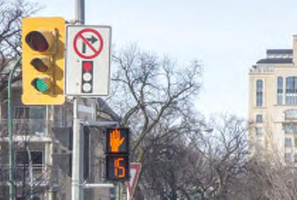
4 input. Four computers were also set up to encourage participants to complete the online interactive survey. If participants were not comfortable using a computer, hard copies of the survey were also available. The results of the comments posted on the presentation boards (Appendix C) and maps (Appendix D) are detailed in Appendix A. 3.0 Key Themes The comments recorded on the presentation boards and maps were collated and the following themes emerged along with a general statement about those themes: Maintenance: There is a desire for the bike infrastructure to be better maintained, especially to be cleared in the winter and cleaned of sand in the spring. Physical Buffer: There is a preference for physical buffers because drivers often dismiss the painted lines. Bike Boxes: There was a general positive interest in bike boxes, but there were some questions about how to use them, driver education, and how they are labelled. Pedestrian Facilities: There is a desire to improve the pedestrian facilities which include more countdown signals, landscaping, and safer crossings at driveways. Existing Bike Lanes: Sharrows were seen as being ineffective and also that the paint wears off too easily. Construction: There is a strong desire for a safe alternative for bike infrastructure when there is construction. Bike Parking: There is a need for more bike parking at key locations such as the library. Norwood/Queen Elisabeth Way Bridges: Users identified these bridges as being dangerous for both cyclists and pedestrians. Connections: There was an overall interest in better connections. Some bike lanes were seen as dead ending, and there are challenges with some of the major intersections. Balancing Users: There was a question of whether or not there is enough space for parking, bike lanes and vehicle travel lanes? 2

5 4.0 Word Cloud The comments from the Public Open House boards and table maps provided in Appendix A are depicted as a word cloud where frequently repeated words appear larger. 3
6 Appendix A Presentation Board and Map Comments The following comments were noted on the following presentation boards: Connecting Downtown (Board 8) Securing year round river walk access would be incredible. Residential on the way for The Forks. Examples of Protected Cycling Infrastructure (Board 9) Necessary part of an active transportation plan to have these in high traffic areas, especially in downtown in rush hour. These are great but better cleaning/clearing of lanes are needed. Having the bus platform in the parking lane as on Sherbrook works well. See MASS DOT guidelines for a better, more accessible design. These [Calgary, AB example with green paint] are AWESOME. Concentrate on safe cycling for seniors. Ideally would limit cyclists need to slow on stop. In other words: allow people to keep riding continuously. Clear signage is important - there is a great deal of confusion for vehicles turning right on Sherbrook. Ensure there is enough width to meet demand, to allow for passing, and to allow for side by side riding. >4 or 9 m for 2-way >2.5 m for one way Examples of Buffered Cycling Infrastructure (Board 10) Physical dividers required or vehicles ignore the painted lines. Winnipeg drivers often ignore or don't notice bike lanes that don't have a physical (rather than painted) buffer. Especially in the winter. Is there more maintenance? Examples of Intersections (Board 11) Bike Boxes I like these: o Cheap o Even without bike lanes o No one loses time or space Bike boxes are great! But education needed for drivers who already have licenses - Winnipeg drivers already ignore pedestrian crossing lines. Bike boxes & signals both sound fantastic! Auto driver education please What happens if I need to turn left and it's green? Leery about these! Give bicycle turning signal lights ahead of vehicles.
7 How are bike boxes labelled in the winter? Bike box Intersections so cyclists can be in front of cars. Cycling signals How can protected bike lanes be carried through the intersection (to maintain the protection)? Can Dutch model be considered? Makes good sense. Cycle traffic signals are great. I used them in Europe. Half signal crossings These are great, but lights must change faster! I agree! Yes - more crossings that don t pretend cyclists will push across. Should not have to, you'd never expect a car to. The light at Osborne and Assiniboine takes way too long to turn green. This encourages crossing against the light. Half signal crossings are way too slow. The wait to cross is way too long. It's faster to take alternate routes which defeat the purpose. Regulating river height at this location would help. Examples of Pedestrian Facilities (Board 12) More of these [pedestrian countdown signals] please. Many of these are underutilized/not comfortably accessible at this time. We need to make sure that things like parklets, trees, and flowerbeds are included to help create great places to visit, not just to drive through. What do any of these have to do with walking as active transportation alternative. Need to re-design driveways ("private approaches" to highlight pedestrian right-of-way. Sidewalks should continue across driveways (and perhaps at other intersections). Existing Road Cross-Sections (Fort Street) (Board 13) Sharrows are completely ineffective in Winnipeg. Sharrows are a waste of paint. They create no new space for cyclists and make no difference in driver behavior. Sharrow really means nothing. But: where you paint, use decent paint! Biking up Fort -> sharrow isn't clearly marked - cars park on it. Feels like sharrow doesn't exist! City needs to ensure bike lanes painted early spring as difficult to see lanes. Use high quality durable paint for all lanes. (painting once instead of twice a year that is gone in a week).
8 Existing Road Cross-Sections (Garry Street) (Board 14) Prioritize clearing of bike paths in the winter. Bike lane is blocked from here to Broadway due to evening rush hour. People ignore the lanes and completely block it so they can turn right. How do we know it is a cycle lane? Existing Pedestrian Facilities (Board 15) What is with that new park at Assiniboine and Main, has no access to Assiniboine from southwest corner, why? Bike lane shifts to the left when you get to the south side of Broadway. Unsafe! Broadway]. Parked cars on Smith at Radisson Hotel - frequent pedestrian barriers - cars parked on sidewalk. Existing Cycling Facilities (Board 16) Southbound cyclist Portage is a mess. Unsafe and should be a priority. Diamond Portage and Main southbound is Crazy. Bike has to sit in second right turn lane and hold up right turn traffic. Try it sometime. Sometimes it's easier to bike in one direction than it is making the return trip. For example, I find it easier to get to the Exchange than it is to head back to my work place at Broadway and Kennedy. Allow cyclists right turns on red. (Ellice turning on to Garry). How are bike lanes connected here [Norwood Bridge/Queen Elizabeth Way]? Are the sidewalks on bridges multi-use? Or if not, where does Assiniboine bike end? Vehicles block bike lane due to large amount of vehicles making right turns. Blockage goes all the way to back lane/parking lot entrance Broadway]. Protected cycling infrastructure only works if there is a minimum of continuity. Allowing construction and maintenance vehicles & equipment to use it is unsafe. Blocking sections for years at a time is a bit of a joke, no? When construction closes a bike route there needs to be a safe transition off it to prevent accidents. Existing Parking Utilization (Board 19) What about bike parking? Some stands & racks are overcrowded every day. More bike racks would be great - hard to find a space by the Millennial Library for example. Consider parklets where parking utilization is low. Existing Traffic Volumes (Board 20) Fort & Garry can lose a travel lane without causing any problems. I won't go so far out of my way to get to path-alternative to Midtown Bridge. We need bike lanes on Donald and Smith. Links to bridges, not dead ends.
9 I second this comment! Existing Land Use (Board 21) Winnipeg Square important destination (shoppers, drycleaner) not enough bike parking. Second that. Mixed uses should be shown. In particular, pedestrian oriented main floor uses (as destinations). Fort Garry Place also office - generates lots of pedestrian trips. Observations (Board 22) Why are Fort + Garry truck routes? Only one efficient access point for cyclists to river walk Assiniboine Avenue. There is a high number of pedestrians. On sidewalks on bridges. On e/s sidewalk Assiniboine to Fort Gibraltar. Need to find a way to separate ped/cycle facilities in these contexts. All parks on Assiniboine are underutilized because of lack of draw. Motor vehicle drivers think bridge is bike path and sometimes menace cyclists on the street [arrow pointing to Norwood/Queen Elizabeth Bridge (QEW)]. Lack of continuity in cycling infrastructure between Assiniboine Avenue & QEW bridge cycle track is frustrating. Water/snow/ice gathers under Midtown Bridge on Assiniboine Avenue. Crossing Assiniboine is hazardous for pedestrians too. Construction [on Assiniboine]. Construction: Could there be policies regarding what happens if construction either blocks a bike lane or reduces space on street to make car passing bike unsafe? Construction should include bike lane. At least notice to cars that we're merging. Lots of bikes, no bike lane on Donald. Taxi pick-up/drop-off for The Pint. How to Get Involved (Board 23) If this is an "Open House on proposed bike lanes", where are pictures/maps/any information on the proposed bike lanes? Because they are gathering suggestions from you before the design process. What are tire talks? Study Area Map Safety Difficult left turn for cyclists on Fort turning on to St. Mary. Yield radius = fast cars. Pedestrian safety issues [north side of Main Street at York Avenue]. Vehicles pass cyclists on the left (wrong lane) when biking EB [Fort Street. and Assiniboine Avenue].
10 Bike lane shifts to the left [South Broadway and Garry]. Vehicles ignore bike lane to turn right [North Broadway and Garry]. Busses & bikes scary to ride & cross Portage Avenue. o Agreed Blind corner for pedestrians going north into Exchange [Ellice and Garry]. *Bike lane on Hargrave Graham. Especially when events are at MTS Centre it's very busy and as a cyclist I don t feel super safe. [sticker at York and Garry] - assumed same comment as Condition - road broken up at Robins Donuts. Getting into and out of protected bike lane on Norwood Bridge is very dangerous southbound and inconvenient northbound. Especially needs attention for cyclists southbound on Main turning east on Marion! Sticker at Norwood Bridge and Lyndale Drive. Garry Street difficult to have a bike lane, vehicle lane, loading, and room for all users. How can you add bike lanes south of Broadway? Nothing against bikes Crossing [Assiniboine and Main pedestrian crosswalk]. Dangerous intersection [Main and York]. Bike box Fort and Portage. Too many conflicts with bus stop, cars waiting to turn right because pedestrians crossing Portage Avenue. Cars turning left from southbound Main often do not notice SB cyclists. o I second that, one of the most regular conflicts on ride to work for me is that intersection. Frequently cars parked on Radisson Hotel - difficult for pedestrians to pass south side Portage Avenue]. Narrow and busy roadway beside MTS centre [Donald Street]. A fast bike lane next to parking is a serious dooring risk on Garry south of York. Poor location of crosswalk forces cyclists to cross in front of traffic on Assiniboine [Main and Assiniboine]. Even though there is a crosswalk, this is most dangerous point of my ride. How about a queued crossing on South Assiniboine to Forks? Like Osborne crossing. [Main and Assiniboine]. The bike separated lane is dangerous to use when you cross the bridge to get back on St. Mary's Road (on the diamond lane) because cars turn on Lyndall Drive. Broadway and Main (going north) doesn't give pedestrians enough time to cross safely at present. Broadway and Main dangerous with short yellow, cyclists still in intersection when pedestrians start to cross. Also, cabs regularly park in the middle of that intersection. Scramble type intersection would be great at Main and Broadway. It is death for pedestrians. Extremely wide and somebody in a car is always trying to turn. A hook turn on NB St. Mary would greatly improve left turns off Main onto St. Mary. Condition Exit from Robins Donuts is broken up. Very treacherous for walking [Garry Street]. Pedestrian underpass terrible; pigeon droppings, splashing by cars, poor pavement.
11 o Agree! Aesthetics Liven-up landscaping in the median [Sticker at Broadway between Main Street and Fort Street]. Amenities Shared sidewalk [east side Main Assiniboine]. Connections [Sticker at Main Street and York Avenue]. Bike path & crosswalk need to flow. High traffic area. Crossing should be elevated changed to allow bikes, pedestrians and cars to flow freely [arrow pointing to Main and Broadway pedestrian crossing]. Fort - lights are slow/not synced well. I avoid by turning onto Smith then right on to York then left on to Fort. Keep routes direct, minimize any delays at intersections. Connection to Arthur/Exchange District difficult Notre Dame]. Connection sticker at QEW Bridge and riverwalk. S/B at underpass at Bridge north of River. May require upgrading section of riverwalk or additional section of trail to stay dry. Would reduce crossings at Assiniboine Avenue. Main Street to The Forks needs a connection. We're ending up on the sidewalk. Assiniboine to Millennium Library - getting there on bike with kids not easily done. Would like safer connection I can take my 6-year old on. Access to Churchill Drive path from Main Street. Southbound Portage diamond lane for bikes is in second right turn lane with a timed traffic light allowing turns before straight means cars waiting to turn stuck behind bikes going straight. Will there be anything north side to tie into bike lanes already in Exchange, e.g., to get to HSC? Bannatyne/McDermot bike lanes? [Portage and Fort]. o I second that! Lack of continuity between Assiniboine cycle track and the Forks makes a mockery of cycle friendly infrastructure. o Agreed! Shared sidewalk cycle traffic going both ways to connect with Forks [west side QEW Bridge]. We need connection to Main Street along St. Mary and York to connect to The Forks. Pedestrian Make more inviting to pedestrians (wayfinding, etc.) [sticker at Broadway and Main]. Same pedestrian underpass comment as condition. Traffic on Broadway and Fort (4 pm 5:30 pm) very congested for pedestrian crossing despite change of lights.
12 Seniors need adequate time on crossing lights to walk across wide streets like Main Street. Pedestrian sidewalks along streets have steep slopes - treacherous in winter. Pedestrian (senior) - Brick surface in sidewalks can be difficult to walk on as it becomes uneven - some styles are very slippery in winter. Push button does not reset when already pushed by a previous crosser Assiniboine crossing]. Other No infrastructure on Smith or Donald means we need some. Parkade with private bike parking (215 Garry). Signal issue - traffic William and King confusing. Need turn signal. Please mark cycling detours when construction blocks the route. It would be great to be able to cycle west down Assiniboine to Osborne on the one way road. When there is no vehicle traffic and a long red light, it would be nice to have a cyclist push button in a convenient location so we don't have to push the pedestrian button. Want Assiniboine to stay as two lanes for vehicles. o Disagree! Assiniboine Cycle Track - cars still drive into cycle track (westward). Fort Garry Place has no visitor parking or on-street parking. o Do not add cycle track by removing parking lane o Many seniors in this block and need vehicle lanes and good sidewalks o Bike paint is poor Cycle track curb too low to see. o Lighting needs to be improved around this area Access out of Fort Garry Place parkade onto Assiniboine. o Traffic from Main o Design of curbs - takes too much lanes from vehicles o Snow embankment too high also o Nothing against bicyclist Bridge [arrow pointing to parking lot north of Assiniboine and Main pedestrian crossing]. Turning right Fort to Broadway need to: o Watch cyclists o Educate drivers on turning movements when you have a bike lane Sidewalk narrows at points here - very busy during morning commute. o Wide sidewalk at bus stop would be appreciated [Graham between Fort and Garry] Need bike parking. Issue with parkade merging onto Fort just as current bike lane ends. What about Donald and Smith? Why are you not proposing lanes on these streets? Bike lane moves left to right, putting cyclists in danger due to conflict with traffic [Fort and Broadway].
13 Is this bridge [QEW] crossing southbound shared use or not? Assiniboine bike lane is pushed out onto sidewalk eastbound, but are bikes allowed there, and if so, how far? The two-way cycle track leading up to Main St. from The Forks is fabulous. Thank you whoever designed that.
14 Appendix B Hard Copy Survey
15 DOWNTOWN BIKE SYSTEM STUDY PUBLIC OPEN HOUSE OCTOBER 20, 2015 COMMENT SHEET RANKING Please rank your top three priorities for Fort Street and Garry Street On-street parking and loading zones User safety and comfort Comfort as a pedestrian Safe cycling environment Connections to amenities Accessibility for all users Transit access and service Vehicular traffic flow Other: Additional comments: 1


16 PREFERENCES Place a checkmark beside the option that best represents your personal preference PARKING & LOADING IMPACTS [Choose one] Which option best represents your personal preference? Maintain as much on-street parking and loading as possible Provide space for painted buffers or traffic separators TRANSIT STOPS [Choose one] Which option best represents your personal preference? Transit stop in the bike lane; cyclists have the option to wait behind the bus or overtake on the left Transit stop outside the bike lane; cyclists must stop and yield to passengers getting on and off the bus Bike lane to travel around the transit stop; cyclists can continue when the bus is loading/unloading 2
![LEFT-TURN OPTIONS [Choose one] Which option](/docs-images/86/93329179/images/17-0.jpg "best represents your personal preference?")


![left turn CYCLING COMFORT [Choose one]which](/docs-images/86/93329179/images/17-3.jpg "option Only cycle on bike lanes separated from")

17 LEFT-TURN OPTIONS [Choose one] Which option best represents your personal preference? No cycling-specific intersection markings Left turn bike box for cyclists making a vehicular-style left turn Two-stage bike box to help cyclists make a two-stage pedestrianstyle left turn CYCLING COMFORT [Choose one]which option best represents your personal preference? Only cycle on bike lanes separated from traffic Comfortable cycling in traffic on almost any road without bike lanes 3
18 TYPE OF SEPARATION [Choose one] Which option best represents your personal preference? Paint only; cyclists can enter/exit anywhere but are vulnerable to car traffic Buffered bike lane; cyclists can enter/exit at fewer locations but cars are discouraged from entering Bike lane separated by parking; horizontal separation from through traffic; cyclists can enter/exit at fewer locations but are vulnerable to illegal car parking Bike lane separated by a raised curb; physical separation from through traffic or parking; cyclists can enter/exit at fewer locations and cars are blocked from entering Additional comments: 4
19 Is there anything else you would like to tell us? Please answer the following questions to help us understand your input better How did you learn about today s Public Open House? (check all that apply): Newspaper advertisement Facebook City of winnipeg website Twitter Newsletter Other: invitation Age Under and above Gender First 3 digits of your postal code What is your primary mode of transportation? Cycling Walking Public transit Driving Thank you for taking the time to help us better understand what is important to you. We appreciate your valuable input! 5
20 Appendix C Presentation Boards


21 WELCOME Downtown Bike Lane System Connecting The Forks to the Exchange District (Fort St., Garry St. & The Forks to Assiniboine Connection) PUBLIC OPEN HOUSE
22 OPEN HOUSE GOALS Introduce the study Discuss with the study team and other members of the public Allow you to share any specific interests and/or concerns regarding the study Encourage feedback through written and digital comments Learn how to stay involved Please use the sticky notes to post comments directly on the presentation boards. Please provide your input at one of our computer kiosks. 2
23 STUDY AREA THE FORKS N RED RIVER DOWNTOWN STUDY AREA ASSINIBOINE AVE. BROADWAY EXCHANGE MAIN ST. DISTRICT FORT ST. YORK AVE. GRAHAM AVE. ST. MARY AVE. GARRY ST. ASSINIBOINE RIVER PORTAGE AVE. SMITH ST. DONALD ST. 3


24 POLICY CONTEXT Winnipeg s pedestrian and cycling strategies are directly linked to and informed by the City s key long-term planning documents: OurWinnipeg guides the physical, social, environmental, and economic growth and development of our city over the next 25 years. The document outlines the importance of enabling walking and cycling for all Winnipeg residents as a direct way to improve social, environmental and economic sustainability. The Complete Communities Direction Strategy guides land use and development by promoting Complete Communities places that offer and support a variety of transportation options, lifestyle choices, and opportunities for people to live, work, shop, learn and play in close proximity to one another. The Sustainable Transportation Direction Strategy emphasizes moving people, goods, and services in a way that is socially, environmentally, and economically sustainable. The Sustainable Transportation Direction strategy forms the policy framework for the Transportation Master Plan. Winnipeg s Transportation Master Plan presents a long-term strategy for the planning, development, renewal and maintenance of a multi-modal transportation system that is consistent with projected needs, and aligned with the City s growth and overall vision for a sustainable Winnipeg. The document contains directions for the development of a comprehensive pedestrian and cycling strategy. 4
25 WINNIPEG S PEDESTRIAN & CYCLING STRATEGIES WINNIPEG PEDESTRIAN & CYCLING STRATEGIES PEDESTRIAN & CYCLING ACTION PLAN DOWNTOWN BIKE SYSTEM Adopted by City Council in July Originates from the 2011 Transportation Master Plan and establishes directions for walking and cycling polices, infrastructure, and programs over the next 20 years. The recommended strategies seek to maximize transportation options by ensuring the accessibility, comfort, and safety of walking and cycling in Winnipeg with downtown being one of the first priorities. Adopted by City Council in May Outlines the Public Service s annual recommendations for yearly capital budget spending associated with walking and cycling. This study was approved through the 2015 Action Plan. The Winnipeg Pedestrian and Cycling Strategies recommend that the City of Winnipeg engage in neighbourhoodbased public engagement when pursuing pedestrian and cycling projects. 5
26 STUDY GOALS Develop a plan to upgrade the existing pedestrian and cycling facilities downtown while renewing the roads. Enable people of all ages and abilities to feel safe and comfortable walking and cycling downtown. Improve the vibrancy of downtown by providing improved walking and cycling opportunities and by enhancing the area as a destination. Contribute to quality of life and community well-being through an enhanced pedestrian realm. Support reinvestment in Winnipeg s downtown by connecting two of Winnipeg s prominent neighbourhoods; The Forks and the Exchange District. Engage citizens and receive input that will be considered in the final design. 6
27 TIMELINE We are here PUBLIC ENGAGEMENT SEPTEMBER 2015 OCTOBER 2015 JANUARY 2016 MARCH 2016 Gather Present Study Kick-Off Gather Input from the Public Feedback on Preliminary Recommended Design Options SEPTEMBER 2015 TO OCTOBER 2015 OCTOBER 2015 TO DECEMBER 2015 JANUARY 2016 TO FEBRUARY 2016 MAY 2016 Analyze Develop Refine Study Information Preliminary Recommended Report on Existing Options Design Conditions TECHNICAL 7

28 CONNECTING DOWNTOWN Downtown Exchange District Arts and Culture Shopping Education Restaurants Hotels Offices Residential N Entertainment Library Hotels Restaurants Shopping Offices Residential Education The Forks Broadway & Assiniboine Restaurants Offices Residential Museums Restaurants Shopping Hotel Osborne Village Entertainment Restaurants Shopping Residential 8


29 EXAMPLES OF PROTECTED CYCLING INFRASTRUCTURE WINNIPEG, MB CALGARY, AB WINNIPEG, MB CALGARY, AB FEATURES: IMPLICATIONS: Safest on-street cycling facility More road right-of-way is required for protected facilities than for Physical barrier minimizes vehicle encroachment into the bike lane Eliminates risk of collisions with over-taking vehicles Minimizes door zone conflicts between parked cars and cyclists More attractive to a wider range of cyclists painted lanes and sharrows In some cases pedestrians are required to cross the facility to access transit and/or parked cars Requires additional maintenance (curbs, planters, bollards and snow removal) 9


30 EXAMPLES OF BUFFERED CYCLING INFRASTRUCTURE WINNIPEG, MB NORTH YORK, ON NORTH YORK, ON FEATURES: IMPLICATIONS: More attractive to cyclists than painted bike lanes and sharrows Provides more space between cyclists and automobiles without being wide enough to be mistaken as an automobile travel lane Lack of physical barrier between automobiles and cyclists reduces safety for cyclists More maintenance required than painted bike lanes and sharrows Provides additional space for cyclists to pass each other without entering the vehicle travel lane Less maintenance required than protected facilities 10


31 EXAMPLES OF INTERSECTIONS BIKE BOXES CYCLING SIGNALS HALF SIGNAL CROSSINGS TORONTO, ON WINNIPEG, MB Features: Features: Features: Increases cycling efficiency by eliminating queuing in cycling lanes & allowing cyclists to start first Reduces conflict points between cyclists and motorists during left and right turns Increases the visibility of cyclists making left and right turns Highlights the conflict point for vehicles and improves visibility of cyclists Mitigates conflict between right turning vehicles and cyclists Simplifies bicycle movements through complex intersections, promoting safety and awareness Provides greater surety that automobiles will stop Creates gaps for cyclists to cross busy streets safely Increases cyclist compliance with traffic controls 11


32 EXAMPLES OF PEDESTRIAN FACILITIES These examples contribute to a safe and comfortable pedestrian environment 12


33 EXISTING ROAD CROSS SECTIONS Fort St. North of Broadway - facing north Fort St. South of Broadway- facing north SIDEWALK PARKING DRIVING DRIVING BIKE PARKING SIDEWALK SIDEWALK PARKING DRIVING SHARROW SIDEWALK SIDEWALK PARKING DRIVING DRIVING BIKE PARKING SIDEWALK SIDEWALK PARKING DRIVING SHARROW SIDEWALK 13


34 EXISTING ROAD CROSS SECTIONS Garry St. North of Broadway - facing north Garry St. South of Broadway - facing north SIDEWALK PARKING BIKE DRIVING DRIVING PARKING SIDEWALK SIDEWALK PARKING BIKE DRIVING PARKING SIDEWALK SIDEWALK PARKING BIKE DRIVING DRIVING PARKING SIDEWALK SIDEWALK PARKING BIKE DRIVING PARKING SIDEWALK 14
35 EXISTING PEDESTRIAN FACILITIES N MAIN ST. ASSINIBOINE AVE. FORT ST. GARRY ST. BROADWAY YORK AVE. GRAHAM AVE. SMITH ST. DONALD ST. PORTAGE AVE. ST. MARY AVE. LEGEND SIDEWALK MARKED CROSSWALK OVERHEAD WALKWAY PEDESTRIAN CORRIDOR PEDESTRIAN BENCH 15
36 EXISTING CYCLING FACILITIES N MAIN ST. ASSINIBOINE AVE. FORT ST. GARRY ST. BROADWAY YORK AVE. GRAHAM AVE. SMITH ST. DONALD ST. PORTAGE AVE. ST. MARY AVE. LEGEND DIAMOND PAINTED BIKE SHARED PROTECTED BIKE BIKE PARKING 16

37 EXISTING TRANSIT USAGE N Ja Ja MAIN ST. Ja Ja ASSINIBOINE AVE. Ja Ja Ja FORT ST. YORK AVE. Ja Ja Ja Ja Ja Ja GARRY ST. Ja Ja Ja Ja Ja Ja Ja GRAHAM AVE. ST. MARY AVE. SMITH ST. DONALD ST. Ja BROADWAY PORTAGE AVE. LEGEND TRANSIT ROUTE HIGH VOLUME TRANSIT ROUTE Ja Ja Ja TRANSIT STOP - <100 RIDERS PER DAY TRANSIT STOP - <500 RIDERS PER DAY TRANSIT STOP - >1,000 RIDERS PER DAY 17

38 EXISTING ON-STREET PARKING & LOADING N YORK AVE. ASSINIBOINE AVE. MAIN ST. FORT ST. GARRY ST. GRAHAM AVE. SMITH ST. DONALD ST. BROADWAY PORTAGE AVE. ST. MARY AVE. LEGEND 2 HOUR DAYTIME PARKING LOADING ZONE ACCESSIBLE PARKING 18
39 EXISTING PARKING UTILIZATION NOTES: UTILIZATION IS BASED ON THE FOLLOWING FORMULA: N ANNUAL TRANSACTIONS MAX POSSIBLE ANNUAL TRANSACTION BASED ON A DAILY AVERAGE UTILIZATION GREATER THAN 100% RESULTS FROM: MORE VEHICLES USING SPACE THAN OFFICIAL LISTED CAPACITY VEHICLES NOT STAYING FOR FULL TIME PAID FOR AND STALL BECOMES OCCUPIED AS SOON IT IS EMPTY ASSINIBOINE AVE. MAIN ST. FORT ST. GARRY ST. BROADWAY PORTAGE AVE. SMITH ST. YORK AVE. DONALD ST. LEGEND >100% % ST. MARY AVE % GRAHAM AVE % >50% NO PARKING NO DATA 19
40 EXISTING TRAFFIC VOLUMES N 51,050 3,750 40,110 19,510 19,420 21,150 5,090 MAIN ST. ASSINIBOINE AVE. MAIN ST. FORT ST. 4,220 1,020 31,810 31,830 4,200 1,000 1,010 5,905 11,140 11,420 9,250 GARRY ST. 3,250 10,100 30,270 8,350 28,810 9,120 5,370 12,210 14,800 13,190 SMITH ST. DONALD ST. ST. MARY AVE. 3,010 14,280 5,420 11,850 11,400 11,210 YORK AVE. 11,700 14,390 14,460 BROADWAY 8,590 10,520 13,000 10,200 LEGEND 10,200 GRAHAM AVE. >20,000 VEHICLES PER DAY 12,480 10,000-20,000 VEHICLES PER DAY PORTAGE AVE. 5,000-10,000 VEHICLES PER DAY 0-5,000 VEHICLES PER DAY 20
41 EXISTING LAND USE N ASSINIBOINE AVE. BROADWAY MAIN ST. FORT ST. YORK AVE. GRAHAM AVE. ST. MARY AVE. GARRY ST. PORTAGE AVE. SMITH ST. DONALD ST. LEGEND Off-Street Parking Retail, Restaurant, Hotel Park and Plaza Residential Office 21
42 OBSERVATIONS Recessed Entrance Left-turning Traffic Uses Gaps Created by Pedestrian Corridor Busy Tansit Stop N Please Add Your Blind Corner - Dangerous for Pedestrians and Cyclists Cyclists Ride on Sidewalk to Cross the Bridge Observations with the Post-it Notes Provided Pedestrian Oriented Street Lighting on Graham Deep Recessed Door Fort St. Narrows South of Broadway Cyclists Must Cross Assiniboine Sidewalk Bump Out With Trees, Bike Racks and Parked Scooters. Conflict Between Right Turning Vehicles and Cyclists ASSINIBOINE AVE. Upper Fort Garry MAIN ST. BROADWAY GRAHAM AVE. FORT ST. YORK AVE. GARRY ST. Mature Street Trees Between Assiniboine and Broadway PORTAGE AVE. SMITH ST. Condo Building Under Construction DONALD ST. Blind Corner - Dangerous for Pedestrians and Cyclists GENERAL OBSERVATIONS Pedestrian Refuge, Temporary Art Installation and Benches NEW INVESTMENT IN THE AREA INCLUDING OFFICES, RETAIL STORES AND RESTAURANTS/BARS SURFACE PARKING LOTS REPRESENT LONG TERM DEVELOPMENT POTENTIAL Proposed Development Site - High Rise Condo ST. MARY AVE. PAVEMENT CONDITIONS VARY Building Undergoing Renovations Plaza with Trees & Benches Peg City Car Co-op Car Location SIDEWALKS HAVE INCONSISTENT SURFACE TREATMENT INCONSISTENT ACCESSIBILITY STANDARDS 22
43 HOW TO GET INVOLVED Public engagement is a key component of this study and there will be several opportunities to provide input and ask questions throughout. We are here Ongoing Public Engagement including Website OCTOBER 2015 JANUARY 2016 MARCH 2016 Stakeholder Meetings Open House Tire Talks Walkabouts Online Interactive Survey Stakeholder Meetings and Open House Final Community Event 23
 and (cityofwinnipeg) Please")
44 THANK YOU & PLEASE STAY IN TOUCH On behalf of the Study Team, thank you for your attendance and participation. To stay informed about the study process: Please visit winnipeg.ca/walkbikeprojects where you can also join the list to be notified about upcoming public engagement opportunities Follow the City of Winnipeg on and (cityofwinnipeg) Please provide your input prior to leaving at one of our computer kiosks 24
45 Appendix D Table Maps

46 MA FO K R YO R A G I S S A M. ST Y R A M A AH P. T S D L B I N I O E N G A T R O A N DO T I SM. E AV. T S H. T S Y R B I IN. T S T R. T S IN S S A EXCHANGE DISTRICT DOWNTOWN STUDY AREA THE FORKS RE R E N I O. E V A E Y A W D A O BR. E AV. E AV GR. E V A E RI VE R MAP MARKERS D Show us where you encounter challenges, where walking and cycling are enjoyable, and your ideas for improvement. What is your experience as a cyclist or pedestrian travelling through the Downtown? Place an icon sticker on to the map and leave a comment. V I R Other Pedestrian Connections Amenities Aesthetics Condition Safety N

47 Recessed Entrance Left-turning Traffic Uses Gaps Created by Pedestrian Corridor Busy Transit Stop N Blind Corner - Dangerous for Pedestrians and Cyclists Cyclists Ride on Sidewalk to Cross the Bridge Pedestrian Oriented Street Lighting on Graham Deep Recessed Door Fort St. Narrows South of Broadway Cyclists Must Cross Assiniboine Sidewalk Bump Out With Trees, Bike Racks and Parked Scooters. Conflict Between Right Turning Vehicles and Cyclists ASSINIBOINE AVE. Upper Fort Garry DOWNTOWN STUDY AREA MAIN ST. BROADWAY GRAHAM AVE. FORT ST. YORK AVE. GARRY ST. Mature Street Trees Between Assiniboine and Broadway PORTAGE AVE. SMITH ST. Condo Building Under Construction DONALD ST. Blind Corner - Dangerous for Pedestrians and Cyclists GENERAL OBSERVATIONS Pedestrian Refuge, Temporary Art Installation and Benches NEW INVESTMENT IN THE AREA INCLUDING OFFICES, RETAIL STORES AND RESTAURANTS/BARS SURFACE PARKING LOTS REPRESENT LONG TERM DEVELOPMENT POTENTIAL Proposed Development Site - High Rise Condo ST. MARY AVE. PAVEMENT CONDITIONS VARY Building Undergoing Renovations Plaza with Trees & Benches Peg City Car Co-op Car Location SIDEWALKS HAVE INCONSISTENT SURFACE TREATMENT INCONSISTENT ACCESSIBILITY STANDARDS
48 Appendix E Public Open House Invite Letter and Handout
 You are invited to attend an Open House about developing a plan to upgrade the existing bike lanes on Fort Street and Garry Street as well as an improved connection between the")
49 PUBLIC OPEN HOUSE DOWNTOWN BIKE SYSTEM CONNECTING THE FORKS TO THE EXCHANGE DISTRICT (FORT ST., GARRY ST. & THE FORKS TO ASSINIBOINE AVE. CONNECTION) You are invited to attend an Open House about developing a plan to upgrade the existing bike lanes on Fort Street and Garry Street as well as an improved connection between the Assiniboine Avenue protected bicycle lanes and the new bicycle lanes connecting to The Forks. This event is the beginning of the public engagement process for the project and will allow you to share your thoughts on the future design for the project with the planners and engineers. We want to meet with and learn from you about what is important to you as we move forward with the project, before beginning to design the specific plans. We Want to Hear From You Drop-in format (come and go at any point). Learn about the purpose of the study. View presentation boards and talk with project team members. Provide your input and feedback. DATE: Tuesday, October 20, 2015 TIME: LOCATION: 4:00-7:00 p.m. Manitoba Children s Museum (The Great Hall) 45 Forks Market Rd. N Project Contact: David Jopling / / joplingd@mmm.ca For detailed information, updates about this project, to join the mail list, or to provide feedback through our interactive website (available later this month) please visit:
50 Appendix F Map of Mail-out Area

51
Winnipeg Walk Bike Projects Downtown Tire Talk - Summary
 Winnipeg Walk Bike Projects Downtown Tire Talk - Summary Downtown Projected Bike Lane System Connecting The Forks to the Exchange District (Fort Street, Garry Street & The Forks to Assiniboine Connection)
A CHANGING CITY. of Edmonton, it is essential that it reflects the long-term vision of the City.
 A CHANGING CITY By the year 2040, Edmonton will be home to more than 1 million people. To accommodate growth and support a healthy and compact city, we need a new approach to development/redevelopment
Tonight is for you. Learn everything you can. Share all your ideas.
 Strathcona Neighbourhood Renewal Draft Concept Design Tonight is for you. Learn everything you can. Share all your ideas. What is Neighbourhood Renewal? Creating a design with you for your neighbourhood.
Moving Forward with Winnipeg's Downtown Protected Cycling Network
 Moving Forward with Winnipeg's Downtown Protected Cycling Network Kerra Mruss, P.Eng., Manager Transportation Planning, WSP Canada Group Limited Scott Suderman, P.Eng., Transportation Facilities Planning
PEDESTRIAN ACTION PLAN
 ATTACHMENT 2 CITY OF SANTA MONICA PEDESTRIAN ACTION PLAN CITY OF SANTA MONICA PEDESTRIAN ACTION PLAN This page intentionally left blank EXECUTIVE SUMMARY CHAPTER 1 EXECUTIVE SUMMARY Setting the Stage
Bicycle Facilities Planning
 Bicycle Facilities Planning Overview Types of Cyclists Purpose for Riding Types of Facilities Bike Lanes Bicycle Boulevards Cycle Tracks Intersections Signals Signing and Marking Discussion Types of Bicyclists
EXECUTIVE SUMMARY. Vision
 Vision Walking and bicycling in Salt Lake City will be safe, convenient, comfortable, and viable transportation options that connect people to places, foster recreational and economic development opportunities,
Active Transportation Facility Glossary
 Active Transportation Facility Glossary This document defines different active transportation facilities and suggests appropriate corridor types. Click on a facility type to jump to its definition. Bike
City of Davis East Covell Corridor Plan
 Community Open House #2 January 22, 2014 6:00 8:00 p.m. Veterans Memorial Center, Club Room City of Davis Introduction The (ECCP) is a taking a comprehensive look at the existing transportation systems
Draft North Industrial Area-Wide Traffic Plan
 Summary of North Industrial and Hudson Bay Industrial Recommended Improvements Table 1. Summary of s Item Location 1 2 3 4 5 6 7 8 9 10 11 12 Millar Ave north of 51st St Super 8 Motel back lane 400 Block
Complete Streets. Designing Streets for Everyone. Sarnia
 Complete Streets Designing Streets for Everyone Sarnia Complete Streets ~ Sarnia ~ 2018 Introduction Our City is made up of a network of streets that we use to go for a walk, cycle to work, drive to the
Agenda. Overview PRINCE GEORGE S PLAZA METRO AREA PEDESTRIAN PLAN
 PRINCE GEORGE S PLAZA METRO AREA PEDESTRIAN PLAN May 28, 2008 Agenda Welcome and introductions Project overview and issue identification Planning context and strengths Design challenges and initial recommendations
CONNECTING PEOPLE TO PLACES
 CONNECTING PEOPLE TO PLACES 82 EAST BENCH MASTER PLAN 07 Introduction The East Bench transportation system is a collection of slow moving, treelined residential streets and major arteries that are the
Governance and Priorities Committee Report For the July 2, 2015 Meeting
 CITY OF VICTORIA For the July 2, 2015 Meeting To: Governance and Priorities Committee Date: From: Subject: Brad Dellebuur, A/Assistant Director, Transportation and Parking Services Executive Summary The
CURBSIDE ACTIVITY DESIGN
 5 CURBSIDE ACTIVITY DESIGN This chapter provides design guidance for separated bike lanes adjacent to curbside activities including parking, loading and bus stops. Typical configurations are presented
Cycle Track Design Best Practices Cycle Track Sections
 Design Best Practices Sections It is along street segments where the separation and protection methods of cycle tracks offer more comfort than conventional bicycle lanes, and are more attractive to a wide
Bellevue Downtown Association Downtown Bike Series
 Bellevue Downtown Association Downtown Bike Series Meeting 2 Franz Loewenherz Andreas Piller Kyle Potuzak Chris Long October 26, 2017 Today s Agenda: 1) Meeting Purpose 2) 9/28 Meeting Recap 3) Candidate
2014/2015 BIKE ROUTE PLAN 83 AVENUE PROTECTED BIKE LANE
 About the Project 2014/2015 BIKE ROUTE PLAN The City of Edmonton is planning a major bike route on the south side of Edmonton. This bike route is one part of a plan to provide citizens with transportation
50 Avenue S.W. Corridor Study Glenmore Aquatic Centre Drop-In Event
 Project overview The City of Calgary is conducting a transportation corridor study of 5 Avenue S.W., between Crowchild Trail and 4A Street S.W. In 29, it was reclassified as a Parkway under the Calgary
WELCOME. Purpose of the Open House. Update you on the project. Present a draft recommended plan. Receive your input
 WELCOME Purpose of the Open House The Town of Smiths Falls has initiated the Beckwith Street Redevelopment Plan that includes the preparation of a streetscape functional design for the renewal of Beckwith
Appendix C. TRAFFIC CALMING PROGRAM TOOLBOX
 Appendix C. TRAFFIC CALMING PROGRAM TOOLBOX PHASE I...2 Do Not Enter Sign...3 One-Way Sign...4 Turn Prohibition...5 Pavement Markings...6 Speed Monitoring Trailer...7 Neighborhood Speed Watch...8 Police
City of Seattle Edward B. Murray, Mayor
 City of Seattle Edward B. Murray, Mayor Department of Transportation Scott Kubly, Director Eastlake Community Council 117 E Louisa St. #1 Seattle, WA 98102-3278 January 28, 2016 RE: Roosevelt to Downtown
Duwamish Way-finding and CTR Report
 V. North Tukwila When the North Tukwila Manufacturing and Industrial Center was designated in 1992 as part of the region s land use and transportation plan, the plan called for the area to set a light-rail
Chapter 2. Bellingham Bicycle Master Plan Chapter 2: Policies and Actions
 Chapter 2 Bellingham Bicycle Master Plan Chapter 2: Policies and Actions Chapter 2: Policies and Actions The Bicycle Master Plan provides a road map for making bicycling in Bellingham a viable transportation
Southview Blvd & 3 rd Avenue Improvement Project. Public Open House December 4, to 7pm
 Southview Blvd & 3 rd Avenue Improvement Project Public Open House December 4, 2014 5 to 7pm Southview Blvd & 3 rd Avenue Public Information Meeting Agenda Presentation 5:30 to 6:15 pm Purpose of Project
PRINCE GEORGE S PLAZA METRO AREA PEDESTRIAN PLAN
 PRINCE GEORGE S PLAZA METRO AREA PEDESTRIAN PLAN May 28, 2008 Agenda Welcome and introductions Project overview and issue identification Planning context and strengths Design challenges and initial recommendations
City of Sammamish. Welcome. Issaquah-Fall City Road Improvements Project Phase I Design: 242nd Avenue SE to Klahanie Drive SE
 Welcome Welcome to the third community meeting for the Issaquah-Fall City Road Improvements Project. AGENDA 6:00 p.m. Welcome and sign-in 6:10 p.m. Presentation 6:50 p.m. Open house Learn about the roadway
University of Victoria Campus Cycling Plan Terms of Reference. 1.0 Project Description
 University of Victoria Campus Cycling Plan Terms of Reference 1.0 Project Description The Campus Cycling Plan, a first for the University, will provide a comprehensive and coordinated approach to support
Transportation Assessment
 Transportation Assessment Midtown Open House February 10, 2018 Overview Midtown in Focus Overview & Purpose of Today Transportation Assessment overview Summary of Transportation work to date Review & Analysis
Proposed. City of Grand Junction Complete Streets Policy. Exhibit 10
 Proposed City of Grand Junction Complete Streets Policy Exhibit 10 1 City of Grand Junction Complete Streets Policy Vision: The Complete Streets Vision is to develop a safe, efficient, and reliable travel
122 Avenue: 107 Street to Fort Road
 : 107 Street to Fort Road November 24, 2015 4:30 8:00 p.m. Meeting Purpose Summarize project work completed to date Share results of public input from Phase 1 Share the draft concept plan and proposed
City of Novi Non-Motorized Master Plan 2011 Executive Summary
 City of Novi Non-Motorized Master Plan 2011 Executive Summary Prepared by: February 28, 2011 Why Plan? Encouraging healthy, active lifestyles through pathway and sidewalk connectivity has been a focus
Summary of Comments Public Meeting: Marietta Street Resurfacing Project Atlanta Contemporary August 29, 2017 / 6:00 pm to 8:00 pm
 Renew Atlanta hosted a public meeting to discuss the Marietta Street Resurfacing project at. Councilmember Cleta Winslow attended the public meeting, where over seventy (70) citizens to include representatives
2014/2015 BIKE ROUTE PLAN 83 AVENUE PROTECTED BIKE LANE
 About the Project The City of Edmonton is planning a major bike route on the southside of Edmonton. The Strathcona Bike Route will connect the communities of Strathcona, Garneau and the University area,
Major Bike Routes 102 Avenue Workshop April 21, 2015
 Major Bike Routes 102 Avenue Workshop April 21, 2015 Our Purpose Today Provide context on how Major Bike Routes fit into Edmonton s future Share information on what we heard in our last phase, and how
Why invest in the 1 Street S.W. Corridor?
 Why invest in the 1 Street S.W. Corridor? This project is an investment in the Beltline Community and Calgary s economy. It is anticipated that The City s investment along this corridor will help with
Solana Beach Comprehensive Active Transportation Strategy (CATS)
") Solana Beach Comprehensive Active Transportation Strategy (CATS) 3.0 Goals & Policies The Solana Beach CATS goals and objectives outlined below were largely drawn from the Solana Beach Circulation Element
Solana Beach Comprehensive Active Transportation Strategy (CATS) 3.0 Goals & Policies The Solana Beach CATS goals and objectives outlined below were largely drawn from the Solana Beach Circulation Element
complete streets design and construction standards public primer City of Edmonton
 complete streets design and construction standards public primer City of Edmonton introduction Complete Streets are streets for everyone: people who walk, wheel, bike, take transit, or drive. They are
Bikeway action plan. Bicycle Friendly Community Workshop March 5, 2007 Rochester, MN
 Bikeway action plan Summary The was held on March 5, 2007 at the Rochester Mayo Civic Center. The workshop was hosted by Rochester-Olmsted County Planning Department in collaboration with the League of
City of Wilsonville 5 th Street to Kinsman Road Extension Project
 City of Wilsonville 5 th Street to Kinsman Road Walking Tour & Neighborhood Workshop Summary Report Public Outreach Overview On July 18 th, 2017, the City of Wilsonville hosted a neighborhood walking tour
Living Streets Policy
 Living Streets Policy Introduction Living streets balance the needs of motorists, bicyclists, pedestrians and transit riders in ways that promote safety and convenience, enhance community identity, create
Public Information Centre
 WELCOME Public Information Centre Father Tobin Road Lougheed Middle School - Library Wednesday November 7, 2012 7:00 p.m.to 9:00 p.m. Please sign in Neighbourhood Traffic Calming Guide Background The City
Austin Avenue Bridges Project. Public Meeting Summary
 Austin Avenue Bridges Project Public Meeting Summary June 29, 2016 Red Table Safety and Connectivity Notes: 1. Would like to see forensic report evaluations 2. What is the lifespan? 3. Extend safety considerations
CITY OF SAINT JOHN TRAFFIC CALMING POLICY
 CITY OF SAINT JOHN TRAFFIC CALMING POLICY VERSION: 1.0 April 10, 2012 Pedestrians, Cyclists and Motorists Sharing Street Spaces CONTENTS INTRODUCTION... 3 POLICY GOAL... 3 POLICY OBJECTIVES... 3 GUIDING
BETHEL ROAD AND SEDGWICK ROAD CORRIDOR STUDY
 DRAFT PLAN City Council Meeting August 14, 2017 STUDY AREA Sedgwick Corridor State Route 160, principal arterial with Class 3 access management designation, commuter and freight route, connection to SR
Dowling/Beaty Cycling Route
 Public Meeting #2 Dowling/Beaty Cycling Route May 17, 2017 6:00 p.m. 8:00 p.m. Parkdale Public Library - Auditorium 1303 Queen Street West How to Participate Share your questions, ideas and concerns We
PEDALING FORWARD. A Glance at the SFMTA s Bike Program for SFMTA.COM
 PEDALING FORWARD A Glance at the SFMTA s Bike Program for 2017-2021 SFMTA.COM INTRODUCTION About This Booklet More people from all walks of life see their bicycle as a more convenient way to get where
Recommended Improvements - Ruby/Banning Neighbourhood Greenway
 MORE PEOPLE BIKING MORE OFTEN Ruby and Banning Streets have the potential to be an important part of the City of Winnipeg s bicycle network, with direct, low stress access to a community centre, multiple
CLOSED. Highlights of the Final Concept Design:
 The final Concept Design is the result of many months of listening, learning, creating, balancing, and understanding different needs and viewpoints, as well as incorporating technical requirements and
TRAVEL PLAN: CENTRAL EUROPEAN UNIVERSITY CAMPUS REDEVELOPMENT PROJECT TRAVEL PLAN. Central European University Campus Redevelopment Project.
 TRAVEL PLAN Central European University Campus Redevelopment Project Page 1 Table of Contents Introduction... 3 Background... 7 Building Users... 7 Transportation in Community Consultation... 7 Summary
COWETA HIGH SCHOOL AND EAST HIGHWAY 51
 COWETA HIGH SCHOOL AND EAST HIGHWAY 51 Lack of sidewalks along Ben Lumpkin Rd. Lack of crosswalks and ramps at intersection. Hwy 51 is wide to cross as a pedestrian. No ADA compliance or connection to
Bridgewater Complete Streets Prioritization Plan and Pedestrian Safety Assessment
 Bridgewater Complete Streets Prioritization Plan and Pedestrian Safety Assessment Presented by Luciano Rabito Manager of Complete Streets Presented to Bridgewater, MA Wednesday, April 26, 2017 6:30 P.M.
Richmond-Adelaide Cycle Tracks
 Public Drop-In Event Richmond-Adelaide Cycle Tracks June 25, 2018 12:00 p.m. 3:00 p.m. 4:30 p.m. 7:30 p.m. Metro Hall, Rotunda 55 John Street 1 Purpose of Event In Scope Communicate an update about the
7/23/2017 VIA . Michael Hanebutt City of Sacramento Community Development Department 300 Richards Boulevard, 3 rd Floor Sacramento, CA 95811
 7/23/2017 VIA EMAIL Michael Hanebutt City of Sacramento Community Development Department 300 Richards Boulevard, 3 rd Floor Sacramento, CA 95811 RE: 65 th Street Apartments (DR17-220) Dear Mr. Hanebutt:
Broad Street Bicycle Boulevard Design Guidelines
 Broad Street Bicycle Boulevard Design Guidelines Building from the strategies introduced in the 2013 Bicycle Transportation Plan and community input received thus far, City Transportation Staff have identified
Frequently Asked Questions (FAQ)
") Frequently Asked s (FAQ) Study Process... 2 Rapid Transit Service and Operations... 5 Public Consultation... 8 Business Impacts... 8 Design and Property Impacts... 9 Construction Impacts...12 Traffic,
Frequently Asked s (FAQ) Study Process... 2 Rapid Transit Service and Operations... 5 Public Consultation... 8 Business Impacts... 8 Design and Property Impacts... 9 Construction Impacts...12 Traffic,
Active Transportation Infrastructure Investment A Business Case
 Active Transportation Infrastructure Investment A Business Case In 2016, the Real Estate Foundation awarded the Capital Regional District a $50,000 grant for Shifting Gears: Land Use Change through Active
FOCUS AREA 1 - Alberta Avenue Pocket Park 3 (121 Ave and 92 St)
") FOCUS AREA 1 - Alberta Avenue Pocket Park 3 (121 Ave and 92 St) New benches Plant evergreen trees Widen existing sidewalk from 1.5m to 1.8m Marked crosswalk 1.8m wide sidewalk Add pedestrian oriented lights
FOCUS AREA 1 - Alberta Avenue Pocket Park 3 (121 Ave and 92 St) New benches Plant evergreen trees Widen existing sidewalk from 1.5m to 1.8m Marked crosswalk 1.8m wide sidewalk Add pedestrian oriented lights
Saskatchewan Drive Roadway Rehabilitation and Shared-Use Path Widening
 Saskatchewan Drive Roadway Rehabilitation and Shared-Use Path Widening We are here today to present the draft plan for the Saskatchewan Drive Roadway Rehabilitation and Shared-Use Path Widening project
NEWMARKET UPHAM S CORNER
 SOUTH STATION Planning Initiative NEWMARKET UPHAM S CORNER COLUMBIA ROAD (P) FOUR CORNERS/GENEVA Working Advisory Group (WAG) Meeting #5 TALBOT AVENUE MORTON STREET BLUE HILL AVE/CUMMINS HWY (P) RIVER
Item to be Addressed Checklist Consideration YES NO N/A Required Description Complete Streets Guidelines
 Passaic County Complete Streets Checklist - Concept Development Project Name Item to be Addressed Checklist Consideration YES NO N/A Required Description Complete Streets Guidelines Existing Plans Have
Evaluation and Changes to Pedestrian Priority Phase Signal (Scramble Crossing) at Bay Street and Bloor Street
 at Bay Street and Bloor Street") PW2.2 STAFF REPORT ACTION REQUIRED Evaluation and Changes to Pedestrian Priority Phase Signal (Scramble Crossing) at Bay Street and Bloor Street Date: February 12, 2015 To: From: Public Works and Infrastructure
PW2.2 STAFF REPORT ACTION REQUIRED Evaluation and Changes to Pedestrian Priority Phase Signal (Scramble Crossing) at Bay Street and Bloor Street Date: February 12, 2015 To: From: Public Works and Infrastructure
South Park Street Bicycle Lane Improvements. Public Engagement. November 2017
 South Park Street Bicycle Lane Improvements Public Engagement November 2017 South Park Street Bicycle Lane Improvements WHAT WE HEARD REPORT Introduction To improve safety and bicycle route continuity
NM-POLICY 1: Improve service levels, participation, and options for non-motorized transportation modes throughout the County.
 Transportation PRINCE WILLIAM COUNTY 2008 COMPREHENSIVE PLAN NON-MOTORIZED PLAN CONTENTS Goals, Policies, and Action Strategies Table 4 (Bike Facility Classifications and Descriptions) Table 5 (Bike Facility
Tunnel Reconstruction South 5 th Street Association October 16, 2018
 Tunnel Reconstruction South 5 th Street Association October 16, 2018 Reconstructing the Tunnel 2 Service During Tunnel Reconstruction April 2019 through July 2020 3 Projected Cross River Travel Paths of
STONY PLAIN ROAD STREETSCAPE
 Jasper Place Revitalization Strategy: Vision The people involved in the Jasper Place Revitalization Strategy envision: Goal 1: Feeling safe in our community Create a community where feeling safe is common--where
Welcome. Welcome to the second open house on the Downtown Transportation Study.
 Welcome 1 Welcome to the second open house on the Downtown Transportation Study. The purpose of this meeting is to: Recap the study objectives Summarize feedback to date Present information on the alternatives
APPENDIX A: Complete Streets Checklist DRAFT NOVEMBER 2016
 APPENDIX A: Complete Streets Checklist DRAFT NOVEMBER 2016 Complete Streets Checklist MetroPlan Orlando s Complete Streets Checklist is an internal planning tool for staff to further implementation of
Chapter 7. Transportation. Transportation Road Network Plan Transit Cyclists Pedestrians Multi-Use and Equestrian Trails
 Chapter 7 Transportation Transportation Road Network Plan Transit Cyclists Pedestrians Multi-Use and Equestrian Trails 7.1 TRANSPORTATION BACKGROUND The District of Maple Ridge faces a number of unique
Tuesday, September 25 th Mount Holly Municipal Complex 400 East Central Avenue 5:30pm to 7:30pm. Activity Stations o Where do you Live?
 Meeting Information Overview The public workshop for the Mount Holly Comprehensive Bicycle Plan occurred on September 25, 2018. The drop-in workshop allowed attendees to participate in a series of interactive
Improving Cyclist Safety at the Dundas Street West and Sterling Road Intersection
 STAFF REPORT ACTION REQUIRED Improving Cyclist Safety at the Dundas Street West and Sterling Road Intersection Date: August 17, 2012 To: From: Wards: Reference Number: Public Works and Infrastructure Committee
CHAPTER 3: Vision Statement and Goals
 Davidson Walks & Rolls: Active Transportation Master Plan CHAPTER 3 Contents: Overview Vision Statement Measurable Goals Public Outreach CHAPTER 3: Vision Statement and Goals Overview The vision statement
CONNECTIVITY PLAN. Adopted December 5, 2017 City of Virginia Beach
 CONNECTIVITY PLAN Adopted December 5, 2017 City of Virginia Beach CONTENTS 1.0 Background & Purpose... 2 2.0 Existing Inventory & Analysis... 3 ViBe District Existing Walking Conditions... 4 3.0 ViBe District
Make Lincoln Highway an economically vibrant corridor that is safe, efficient, and beautiful for local residents and visitors.
 Lincoln Highway Streetscape Plan Stakeholder Workshop #2 Handout Contents Introduction and Project Vision Planning Principles Specific Recommendations including a Proposed Typical Roadway Section Renderings
Oakland Pedestrian Master Plan Oakland Pedestrian Plan Draft Recommendations Chapter Outline
 EISEN LETUNIC T R A N S P O R T A T I O N, ENVIRO N M E N TA L A N D URBAN PLANNIN G MEMORANDUM To Oakland Pedestrian Plan Technical Advisory Committee & Pedestrian Advisory Group From Victoria Eisen Date
TRANSPORTATION NEEDS ASSESSMENT
 TRANSPORTATION NEEDS ASSESSMENT A travel demand analysis was carried out to determine the operational issues and the potential benefit that adding traffic capacity would have on the road network. All the
THE OFFICIAL GUIDE TO CYCLING SAFELY IN PHILADELPHIA
 B IKE NICE THE OFFICIAL GUIDE TO CYCLING SAFELY IN PHILADELPHIA A partnership of the City of Philadelphia and the Bicycle Coalition of Greater Philadelphia ABOUT VISION ZERO & BIKE NICE It s a great day
Report. Typical Sections. City of Middleton, WI
 Report Typical Sections City of Middleton, WI December 2006 Report for City of Middleton, Wisconsin Typical Sections repared by: Traffic Associates LLC and STRAND ASSOCIATES, INC. 910 West Wingra Drive
MTP BICYCLE ELEMENT UPDATE. November 2017
 MTP BICYCLE ELEMENT UPDATE November 2017 TIME FOR AN UPDATE Bicycle Element adopted in July 2008 Almost 10 years old Many planned facilities have been implemented 10 years more experience in planning,
Omaha s Complete Streets Policy
 Omaha s Complete Streets Policy (Adopted August 2015) VISION To create great places and enhance our quality of life, the City of Omaha will provide safe, accessible streets for all users. Complete Streets
In station areas, new pedestrian links can increase network connectivity and provide direct access to stations.
 The Last Mile Planning for Pedestrians Planning around stations will put pedestrians first. Making walking to stations safe and easy is important; walking will be a part of every rapid transit Accessible
in the pop-up survey after drawing it. UPLOAD PHOTOS when you add a route or point or by clicking on an existing route or point.
 Introduction As part of the first phase for the West Elizabeth Enhanced Travel Corridor Plan an online interactive map WikiMap was created and available for input. A link to the WikiMap was distributed
25th Avenue Road Diet Project A One Year Evaluation. Transportation Fund for Clean Air Project #05R07
 25th Avenue Road Diet Project A One Year Evaluation Transportation Fund for Clean Air Project #05R07 Submitted by: The San Francisco Municipal Transportation Agency Dan Provence May 22, 2009 EXECUTIVE
What is the status of the CPR Yards Crossing Study?
 September 2015 Project Advisory Committee (PAC) Sectors RESIDENTS Centennial Community Improvement Association Dufferin Residents Association of Winnipeg William Whyte Residents Association LOCAL BUSINESS
Richmond, Adelaide and Simcoe Street Pilot Cycle Tracks. Special Report: Opinions of Property Representatives & Drivers
 Richmond, Adelaide and Simcoe Street Pilot Cycle Tracks Public Consultation Summary Special Report: Opinions of Property Representatives & Drivers Prepared by: Jason Diceman, Sr. Public Consultation Coordinator
o n - m o t o r i z e d transportation is an overlooked element that can greatly enhance the overall quality of life for the community s residents.
 N o n - m o t o r i z e d transportation is an overlooked element that can greatly enhance the overall quality of life for the community s residents. 84 Transportation CHAPTER 11 INTRODUCTION Transportation
Vision: Traditional hamlet with an attractive business/pedestrian friendly main street connected to adjacent walkable neighborhoods
 N D. Focus Area II Vision: Traditional hamlet with an attractive business/pedestrian friendly main street connected to adjacent walkable neighborhoods Transit Road Focus Area II is located in the Hamlet
We want to hear from you!
 Welcome Improvement Program We want to hear from you! As part of the Transportation 2040 plan, the City is implementing an ongoing cycling spot improvement program for existing bicycle routes. We are currently
Montford Drive Parking & Circulation Study
 Montford Drive Parking & Circulation Study Parking & Circulation Study Follow up to the Area Plan based on what we heard Purpose 1 2 3 4 To look closer and evaluate parking and network related issues (including
MOBILITY WORKSHOP. Joint City Council and Transportation Commission May 5, 2014
 MOBILITY WORKSHOP Joint City Council and Transportation Commission May 5, 2014 Review of General Plan M-1 Develop world-class transit system M-3 Maintain/enhance pedestrian-oriented City M-4 Create comprehensive
Bike Flemingdon Park and Thorncliffe Park Public Consultation Report
 Bike Flemingdon Park and Thorncliffe Park Public Consultation Report January 2018 Prepared by: Robyn Shyllit Senior Public Consultation Coordinator Public Consultation Unit, City of Toronto Contents Executive
12/4/2016 VIA . RE: Grocery Outlet Del Paso (DR16-328)
") 12/4/2016 VIA EMAIL Ethan Meltzer, Assistant Planner City of Sacramento Community Development Department 300 Richards Blvd, 3 rd Floor Sacramento, CA 95811 RE: Grocery Outlet Del Paso (DR16-328) Dear Mr.
12/4/2016 VIA EMAIL Ethan Meltzer, Assistant Planner City of Sacramento Community Development Department 300 Richards Blvd, 3 rd Floor Sacramento, CA 95811 RE: Grocery Outlet Del Paso (DR16-328) Dear Mr.
MASONIC AVENUE STREET DESIGN STUDY Community Workshop 2. Masonic Ave Street Design Study Community Workshop 2 August 10, 2010
 Masonic Ave Street Design Study Community Workshop 2 August 10, 2010 Introduction MASONIC AVENUE STREET DESIGN STUDY Community Workshop 2 SF Municipal Transportation Agency Javad Mirabdal, Project Manager
Bicycle Master Plan Goals, Strategies, and Policies
 Bicycle Master Plan Goals, Strategies, and Policies Mobilizing 5 This chapter outlines the overarching goals, action statements, and action items Long Beach will take in order to achieve its vision of
WELCOME Public Information Centre
 WELCOME Public Information Centre Fernforest Drive Brampton Soccer Centre Community Room #2 Tuesday January 19, 2016 6:30 p.m.to 9:00 p.m. Please sign in Neighbourhood Traffic Calming Guide Background
ALBERTA AVENUE WHAT WE HEARD REPORT BUILDING GREAT NEIGHBOURHOODS
 ALBERTA AVENUE WHAT WE HEARD REPORT BUILDING GREAT NEIGHBOURHOODS FEBRUARY 2019 EXECUTIVE SUMMARY Starting in 2019, Alberta Avenue will see the replacement and enhancement of its aging collector and local
City of Vallejo Traffic Calming Toolbox
 City of Vallejo Traffic Calming Toolbox June 1, 2013 Final Table of Contents Introduction... 1 Non-Physical Devices... 3 High-Visibility Crosswalk... 3 In Pavement Lighted Crosswalk... 4 Rapid Flashing
Off-road Trails. Guidance
 Off-road Trails Off-road trails are shared use paths located on an independent alignment that provide two-way travel for people walking, bicycling, and other non-motorized users. Trails specifically along
MARTIN LUTHER KING JR. WAY
 OCTOBER 2011 40 Vision and Goals The Martin Luther King, Jr. Way Illustrative Master Plan that follows has been developed through a process of community involvement. It expresses a long term vision for
PROJECT OVERVIEW. 20th Avenue Project Limits (Lincoln Way to Wawona St)
") PROJECT OVERVIEW In 2014, San Francisco adopted Vision Zero as City policy, with a commitment to eliminate all traffic deaths in the City by 2024. nue Project Limits (Lincoln Way to St) Collision data
PROJECT OVERVIEW In 2014, San Francisco adopted Vision Zero as City policy, with a commitment to eliminate all traffic deaths in the City by 2024. nue Project Limits (Lincoln Way to St) Collision data