Keresley Sustainable Urban Extension Sustainable Transport Strategy The Queen s College, Oxford, Bluemark Developments Ltd and CALA Homes Midlands Ltd
|
|
|
- Lorena Cox
- 5 years ago
- Views:
Transcription


1 Keresley Sustainable Urban Extension Sustainable Transport Strategy The Queen s College, Oxford, Bluemark Developments Ltd and CALA Homes Midlands Ltd Final May 2009 WSP Development and Transportation One Queens Drive Birmingham West Midlands B5 4PJ Tel: +44 (0) Fax: +44 (0) WSP UK Limited Registered Address WSP House, 70 Chancery Lane, London, WC2A 1AF, UK Reg No England WSP Group plc Offices worldwide
2 Contents 1 Introduction Background Site Location Development Description Structure of the Report Existing Situation Local Highway Network Public Transport Accession Datasets Calculations Walking Facilities Cycling Facilities Access to Local Amenities Census Data Review Modal Split and Distance Travelled to Work (resident population) Modal Split (Education land uses) Policy National Transport Guidance Planning Policy Statement: PPS1 Delivering Sustainable Development Planning Policy guidance: PPG13 Transport West Midlands Local Transport Plan Coventry Development Plan (CDP) Coventry City Council Walking Strategy Coventry City Council Cycling Strategy Conclusion...35 Keresley Sustainable Transport Strategy
3 Contents 4 Integrated Transport Strategy Introduction Travel Plan Framework Site Masterplan Design Principles Walking Cycling Public Transport Car Travel Outline Improvement Plan Introduction Walking Cycling Public Transport Traffic Generation and Distribution Assessment Traffic Generation Trip Distribution Travel Plan Framework Introduction Benefits of a Travel Plan Policy Existing Sustainable Transport Facilities Proposed Sustainable Transport Facilities Measures ACT Travelwise Summary and Conclusions Keresley Sustainable Transport Strategy
4 Contents Keresley Sustainable Transport Strategy
5 Contents APPENDICES A B Pegasus Urban Design Drawing Bir.2588_20D Information on the NUCKLE provided by Coventry City Council Keresley Sustainable Transport Strategy
6 WSP DEVELOPMENT AND TRANSPORTATION 6 May 2009 Birmingham Office QM Issue/revision Issue 1 Revision 1 Revision 2 Revision 3 Remarks Final Date 6 May 2009 Prepared by Ben Fairgrieve Signature Checked by Phil Taylor Signature Authorised by Phil Taylor Signature Project number File reference KSUE Keresley Sustainable Transport Strategy
7 1 Introduction 1.1 BACKGROUND WSP Development and Transportation (WSPD&T) have previously been commissioned by Bluemark Developments Ltd (BML) and CALA Homes Midlands Limited (CALA) to undertake a strategic highway assessment of the Keresley Sustainable Urban Extension (KSUE), in Coventry which could be allocated for residential development as part of the emerging Local Development Framework (LDF) for Coventry This assessment advised that clear potential exists for bringing this site forward through the LDF process, and subject to the commitment to the provision of the necessary infrastructure improvements and associated measures to ensure that it can be seen to be a truly sustainable site there are no highway or transportation reasons why the land at Keresley could not form a large urban extension to Coventry (WSPD&T) has now been jointly instructed by the Queen s College, Oxford (QCO), Bluemark Developments Ltd (BML) and CALA Homes Midlands Limited (CALA) to provide highways and transportation expertise to progress the KSUE through the core strategy presubmission consultation period and the West Midlands Regional Spatial Strategy Phase 2 revision Examination in Public One of the overarching aims of the developer consortium is to promote the KSUE primarily for high quality residential development, concentrating on release of the land from the Coventry Green Belt and its allocation for housing and associated commercial and community uses. Accordingly this report will concentrate primarily on the work necessary in terms of highways, transportation and sustainability issues to support the KSUE s allocation and promotion. 1.2 SITE LOCATION The KSUE incorporates an area of open land which is predominately in use for agricultural purposes. The area also contains other uses which could be expected in the urban fringe. These include a golf driving range, playing fields, areas of woodland, former mineral workings and recreational open space To the east of the KSUE is the small settlement of Keresley. To the south of the village is the former Coventry Colliery now redeveloped as ProLogis Park. To the south of ProLogis Keresley Sustainable Transport Strategy 1
8 Park is the President Kennedy Secondary School, its playing fields and further south again is the largely residential area which makes up the Holbrook area of the Coventry Beyond the most southerly part of the KSUE is the Cardinal Newman Roman Catholic School and Community College and its playing fields located off Sandpits Lane. To the west are the largely linear settlements of Brownshill Green and Hawkes End. To the northwest is the rural settlement of Corley and further north is the M6 motorway including the Corley Motorway Service Area The KSUE is largely defined by clear boundaries. To the north this KSUE is defined by the administrative boundary between Coventry City Council and Nuneaton and Bedworth Borough Council, which in turn follows a public footpath. The eastern boundary is largely formed by Bennetts Road, with the exception of an area of open land located east of Bennetts Road which in turn is defined by Penny Park Lane, existing development off Brookford Avenue/Bantam Gardens/Hall Brook Road and Watery Lane. To the south the KSUE is defined by Sandpits Lane whilst its western boundary is formed by Tamworth Road. The site location is shown at Figure DEVELOPMENT DESCRIPTION The KSUE will form an urban extension to Coventry comprising some hectares. A development framework for the KSUE is illustrated at Pegasus Urban Design drawing Bir.2588_20D, included at Appendix A of this report. The development proposals for the KSUE comprise some 3,500 residential dwellings, 2 primary schools, employment land uses, community facilities and public open space Due to the mixed use nature of this development, this report will consider sustainable travel in relation to residential, employment and educational land uses. 1.4 STRUCTURE OF THE REPORT Following this brief introduction: Chapter 2 describes the existing situation in terms of strategic highways routes serving employment, education and leisure facilities, as well as a review of the current level of sustainable transport Keresley Sustainable Transport Strategy 2
9 facilities and services in the area and surrounding the proposed development KSUE; Chapter 3 provides a summary of relevant local, regional and national planning policy relating to sustainable transport matters; Chapter 4 considers a proposed integrated transport strategy for the KSUE, encompassing walking, cycling and public transport and how each will link into the development proposals. This strategy will draw upon existing local and regional objectives as well as examples from other development schemes which have been successfully implemented elsewhere in the UK; Chapter 5 describes the outline sustainable transport strategy and improvement plan, identifying key areas where improvements could potentially be implemented, and where relevant these improvements have been tested using industry standard techniques and software; Chapter 6 discusses the potential traffic generation of the development proposals in comparison to other, already established developments with minimal levels of sustainable transport provision; Chapter 7 sets out the Travel Plan Framework for the proposed land development; and Finally, Chapter 8 sets out and summarises the conclusions of this report. Keresley Sustainable Transport Strategy 3
10 2 Existing Situation 2.1 LOCAL HIGHWAY NETWORK The KSUE is situated to the north of Coventry City Centre, as illustrated at Figure 2.1. The principal route into Coventry City Centre from this direction is the B4098 Tamworth Road. From its junction with Light Lane through to J9 on the Coventry Ring Way the road is a dual carriageway of a good quality design Although there are several junctions along Tamworth Road and Keresley Road, this particular route does not suffer from the same level of congestion as do many of the other radial routes leading into Coventry City Centre For traffic travelling from the Keresley area and wishing to travel west towards the Birmingham and Solihull area, there is a priority controlled junction with the B4076 Long Lane. This route allows traffic wishing to travel west to avoid the Coventry Ring Way. This route forms a junction with Holyhead Road (A4114) which is a roundabout controlled junction. This road is well used, particularly at peak times but it is considered to be ideal for its function of relieving pressure in the City Centre Another route that provides a useful connection to the south west is the B4107 Engleton Road that connects Radford Road with Holyhead Road at Four Pounds Avenue An alternative route into the Keresley area is along Bennetts Road. From its junction with Tamworth Road Bennetts Road is generally a 6.5 metre wide road with footways on both sides of the road. The road is of good alignment but is subject to a series of traffic calming measures between Fivefield Road and Grove Lane. These have been introduced in order to control the speed of traffic along this road Once past the junction of Penny Park Lane Bennetts Road adopts a more rural feel with the road being of good alignment until it reaches the county boundary at Keresley Newland From the county boundary Bennetts Road travels in a north westerly direction, skirting the Corley service area and passing over the M6 motorway. The alignment of Bennetts Lane in the vicinity of Corley Hall is poor and the road in places narrows down quite noticeably. Keresley Sustainable Transport Strategy 4
11 2.2 PUBLIC TRANSPORT Public transport is provided in Coventry via a combination of rail and bus services The nearest railway station is Coventry Railway Station which is approximately 6km from the proposed development. This is a mainline station which is served by rail services to Manchester Piccadilly and London Euston railway stations. The station also provided services to intermediate destinations such as Wolverhampton, Birmingham and Northampton railway stations as well as providing additional services to Nuneaton Due the distance of the KSUE from Coventry Railway Station the public transport strategy for the KSUE will focus on bus services only as these serve more local level trips than the rail network which operates at a more strategic scale. It is intended that the local level of service provided by buses will integrate with rail services, allowing long distance sustainable travel to be undertaken, however it is envisaged that the KSUE will generate and attract predominantly local level trips, making bus travel the focus of the public transport strategy, for the KSUE, rather than rail. This assumption is supported by 2001 Census data for distance travelled to work, which is discussed in depth in later sections of this chapter The nearest bus stops to the KSUE are located on Bennett s Road South, Tamworth Road and Sandpits Lane as illustrated at Figure In terms of the number and frequency of bus services, the bus stops located on Bennett s Road South will prove more attractive and further bus stops are located within the adjacent Prologis Park that serve frequent bus services weekdays during the day time A summary of the bus services serving the aforementioned bus stops and their corresponding frequencies is provided at Table 2.1, whilst a plan showing the existing route of each bus service is included as Figure 2.3. Keresley Sustainable Transport Strategy 5
12 Table 2.1: A summary of existing bus services operating within the vicinity of the KSUE Service No. 4A 13A Provider Travel Coventry Travel Coventry 36 Travel Coventry 55 Stagecoach in Warks. 735 Travel Service of Coventry 736 De Courcey Travel Route (Local Stop) Prologis Park University Hospital Via Coventry (Prologis Park) And in reverse Prologis Park Willenhall Via Coventry (Prologis Park) And in reverse Keresley Little Heath And in reverse Coventry Nuneaton Via Keresley And in reverse Coventry Nuneaton Via Keresley And in reverse Prologis Park Coventry And in reverse Weekday Saturday Daytime Evening Daytime Evening Every 30 minutes 2 3 services per hour during peaks Every minutes Every 30 minutes 4 services per day 4 services per day No service No service Every 30 minutes Services at 19:17 and 23:30 No service No service No service No service Every minutes Every 30 minutes 3 services per day No service Source: Network West Midlands website ( No service No service Every 30 minutes Services at 19:16 and 2330 No service No service Sunday No service 2 services per hour between 12:00 and 21:00 Every 30 minutes No service No service No service Keresley Sustainable Transport Strategy 6
13 2.3 ACCESSION Accession, is a travel access and travel time mapping software package which can be used in a wide range of transport related studies. It measures accessibility to and from any point based on time, or distance through highway and public transport networks Accession enables assessments to be made of accessibility for different areas and population groups. It covers a range of transport modes, including public transport, walking and cycling, and can assist in developing solutions to public transport accessibility issues. Popular uses for Accession software include the following: Reviews of existing public transit services; Simplified analysis of effects of proposed service changes; Plans for meeting disabled persons transport requirements; Development of business case for retail location; Site evaluation for property business re-location; Development of green commuting plans for private and public sector organizations; Development of car parking standards based on public transit accessibility levels; and Analysis of school catchment areas and pupil travel requirements Accession has been used on in this instance to determine how accessible the KSUE is by sustainable transport modes currently serving the Keresley area (as summarised at Chapter 2) and has also been used to model the improvement in accessibility as a result of proposed new and extended bus services (as summarised at Chapter 5). The contour tool available in Accession has been used to map the results of the calculations performed in this analysis. The contour map can is used to provide a visual assessment of the public transport accessibility within Keresley and the wider area of Coventry. Keresley Sustainable Transport Strategy 7
14 2.4 DATASETS The Accession model for the KSUE comprises the public transport network, the road network and origin/destination data An appropriate road network was selected that was large enough to allow 60 minutes multimodal travel in each direction from the KSUE. 60 minutes is deemed to be an acceptable journey time for commuting purposes. The selected road network used in the Accession model was sourced from Navteq data The public transport network was built in Accession using a combination of public transport stop data and timetable data. The public transport stop data was obtained from the National Public Transport Access Node (NaPTAN) database which is supported by the Department for Transport. NaPTAN is a UK-wide system for providing a unique identifier for each bus, rail and coach stop in the UK. The timetable data was obtained from the National Public Transport Data Repository (NPTDR) managed on behalf of the Department for Transport The relevant public transport stop and timetable data was obtained for the West Midlands, Worcestershire and Warwickshire regions. 2.5 CALCULATIONS A number of calculations were carried out using the Accession software, assuming peak hour periods of 08:00 to 09:00 hours and 17:00 to 18:00 hours. All calculations were based on a combination of walking to and between bus stops and using sustainable transport modes. The following assumptions were made when calculating existing bus accessibility in the area surrounding the KSUE: Bus users will walk at an average speed of 4.8km/h; Bus users will walk no more than 500m to the first and any connecting bus stops; and Bus users will use at least one service to reach their destination The results of the calculations, performed for the time periods identified above, have been plotted as contour maps showing up to a 60 minute journey time by public transport from Keresley Sustainable Transport Strategy 8
15 the KSUE and broken down into 10 minute intervals and up to a 30 minute journey time, broken down into 5 minute time intervals. The resulting isochrone maps, included as Figures 2.4 and 2.5, show the areas that can be reached during each time period with the KSUE at the centre of the network It is evident that all areas of Coventry City Centre can be reached within 30 minutes by bus and it is also demonstrated that it is possible to reach areas of Bedworth, Corley and Fillongey within a 30 minute journey time by bus alone. 2.6 WALKING FACILITIES There are pedestrian footways accompanied with street lighting on at least one side of the carriageway on the majority of roads surrounding the KSUE, including Bennetts Road, Bennetts Road South, Keresley Green Road, Tamworth Road and Sanpits Lane There are dropped kerbs and tactile paving provided in key locations to aid those crossing the road. There are only a small number of formal pedestrian crossings provided on the existing road network within the vicinity of the KSUE including a zebra crossing on Bennetts Road to the north of the junction with Howat Road and a signal controlled crossing on Tamworth Road near the junction with the High Street Speed calming measures are provided for much of the stretch of Bennetts Road classified as a 30mph speed limit. This acts to reduce the speed vehicles travel and hence enhance the safety of pedestrians in this area There are a number of Public Rights of Way (PROW) running through the site. These run in an east to west direction linking Tamworth Road with Bennetts Road and other roads within the surrounding area. The existing PROW are shown at Figure 2.6 and provide useful linkages and recreational routes around the local area Walking Isochrones have been calculated for 5, 10 and 15 minute journey times on foot using the Network Analyst Extension of ARCView GIS software The walking speed used to calculate the walking isochrones is based on guidance given in Paragraph 3.30 in the IHT s publication Guidelines for Providing for Journeys on Foot which states: An average walking speed of 4.8km/h can be assumed which equates to approximately 400m in five minutes or three miles per hour. It is therefore assumed that in Keresley Sustainable Transport Strategy 9
16 five minutes it is possible to walk 420m, in 10 minutes it is possible to walk 840m and in 15 minutes it is possible to walk 1,260m. The walking isochrones have been plotted on Figure CYCLING FACILITIES Existing cycle routes in Keresley and the wider area of Coventry are illustrated at Figure 2.8. The nearest existing cycle route to the KSUE is accessed off Bennett s Road North and runs parallel to Central Boulevard within Prologis Park This cycle route joins the A444 at the Ricoh Arena and a toucan crossing allows cyclists to access the route running parallel with the A444. This cycle route, via Arbury Avenue and a short stretch of Foleshill Road (both sections of advisory cycle route), leads to the canal towpath which provides access to the perimeter of Coventry City Centre. From this point, there are various other cycle friendly routes available to cyclists The North Warwickshire Cycle Route can be accessed from Tamworth Lane within close proximity of the KSUE. This route is around 35 miles long and uses quiet country lanes, ideal for cycling for leisure purposes Cycling Isochrones have been calculated for 5, 10 and 15 minute journey times by bicycle using the Network Analyst Extension of ARCView GIS software and are summarised at Figure 2.9. These isochrones indicate that it is possible to cycle throughout much of Coventry within a 15 minute journey time, providing sustainable access to local employment opportunities and amenities A cycling speed of 15.8 km/h has been used to calculate the cycling isochrones which has been taken from the Sustrans Information Sheet FF11 or Cycle Friendly Employers Information Sheet and states that a five mile journey can be comfortably cycled by an adult in 30 minutes. It is therefore assumed that in 5 minutes it is possible to cycle a distance of 1,320 m, in 10 minutes it is possible to cycle a distance of 2,640 m and in 15 minutes it is possible to cycle a distance of 3,960 m. Keresley Sustainable Transport Strategy 10
17 2.8 ACCESS TO LOCAL AMENITIES The proximity of local amenities to a site is a key factor when considering sustainability. A wide variety of facilities within walking and cycling distance of a site is likely to result in reduced reliance on the private car for shorter journeys A summary of existing local amenities within close proximity of the KSUE is included at Table 2.2, whilst the location of these amenities is plotted at Figure The distances to each local amenity have been measured from the nearest proposed site access point, as illustrated on drawing Bir.2588_20D, to the specified amenity The location of each local amenity has also been plotted in relation to walking and cycling isochrones, as illustrated at Figures 2.11 and 2.12 respectively in order to demonstrate the existing level of accessibility from the KSUE by sustainable modes of transport. Keresley Sustainable Transport Strategy 11
18 Table 2.2: Summary of existing amenities local to the KSUE Amenity Primary School Pharmacy Secondary School and College Doctors Dentist Convenience Store/ Foodstore/ Newsagent/Post Office Address Distance from nearest site access point (m) Actual Grange Primary School 1,100 Keresley Newland Primary School Whitmore Park Primary School Flemming s Pharmacy Cardinal Newman School and Community College Kennedy School and Community College Opposite link from Keresley Neighbourhood 700 Opposite link from Keresley Neighbourhood Opposite link from Bennetts Road Neighbourhood 1,500 Gables Medical Centre 2,100 Holbrook Health Centre 1,800 Dr Halder 1,700 Keresley Clinic Rotheram Road Dental Practice Opposite link from Bennetts Road Neighbourhood 2,400 Somerfield Stores 1,800 Keresley Supermarket 1,000 Keresley Convenience Store Keresley News 500 Keresley End Post Office 500 Library Keresley Library 200 Cultural and Entertainment Facilities Facilities within Coventry City Centre and at Ricoh Arena Major Commercial Centre Coventry City Centre 5,000 Opposite link from Bennetts Road Neighbourhood 3,000-5,000 General Hospital Walsgrave Hospital 8,000 Keresley Sustainable Transport Strategy 12
19 CENSUS DATA REVIEW The proposed sustainable urban extension was situated in Holbrook Ward. Following the 2001 census a number of ward boundaries across the country have been restructured, one of which was Holbrook. All 2001 census data referenced in this report applies to the previous ward boundary as illustrated at Figure At the time of the 2001 census this ward was classified as being approximately 50% urbanised, with the remainder of the ward comprising open countryside as demonstrated at Figure Holbrook ward, at the time of the 2001 census, also contained a number of the road links which have been identified as being of strategic importance when considering distribution patterns from the KSUE. It is therefore considered that in order to calculate a robust and relevant strategic distribution using 2001 census data that data from this ward, studied in conjunction with data for Coventry metropolitan district, is the most suitable in this instance This ward has been selected as being suitable for calculating forecast trip distribution and modal splits based upon 2001 census datasets UV28 (economic activity) and UV62 (cars and vans). Tables 2.3 and 2.4 summarise each dataset respectively in terms of Holbrook ward and Coventry metropolitan district in its entirety. Table 2.3 Summary of 2001 census dataset UV28 (economic activity) Person Category Holbrook Ward Persons (%) Coventry Metropolitan District Persons (%) Economically Active 8,394 (65.7%) 135,576 (63.1%) Economically Inactive 4,391 (34.3%) 79,257 (36.9%) Total 12,785 (100%) 214,833 (100%) Source: Neighbourhood Statistics website ( Keresley Sustainable Transport Strategy 13
20 Table 2.4 Summary of 2001 census dataset UV62 (cars or vans) Cars or vans/households Holbrook ward Coventry Metropolitan District Number of households 7, ,353 Total cars or vans 7, ,930 Ratio of cars per household Source: Neighbourhood Statistics website ( It is evident that Holbrook ward is comparable to the remainder of Coventry metropolitan district when considering economic activity and car ownership per residential dwelling MODAL SPLIT AND DISTANCE TRAVELLED TO WORK (RESIDENT POPULATION) census datasets UV39 (method of travel to work-resident population) and UV35 (distance travelled to work) have been analysed in order to establish by which mode fo transport and how far residents from Holbrook ward travel to work respectively. Tables 2.5 and 2.6 summarise this information. Keresley Sustainable Transport Strategy 14
21 Table 2.5 Summary of 2001 census dataset UV39 (method of travel to work-resident population) Mode of transport Underground, metro, light rail or tram Holbrook Ward Persons (%) Coventry Metropolitan District Persons (%) 5 (0.1%) 77 (0.1%) Train 69 (0.9%) 1,687 (1.4%) Bus, minibus or coach 1,050 (14.4%) 15,014 (12.8%) Taxi or minicab 37 (0.5%) 662 (0.6%) Driving a car or van 4,449 (60.9%) 71,236 (60.6%) Passenger in a car or van 829 (11.4%) 10,521 (9.0%) Motorcycle, scooter or moped 77 (1.1%) 969 (0.8%) Bicycle 161 (2.2%) 3,573 (3.0%) On foot 599 (8.2%) 13,391 (11.4%) Other 25 (0.3%) 413 (0.4%) All persons 7,301 (100%) 117,543 (100%) Note: calculations do not include those who work mainly from home or those who are not currently working. Source: Neighbourhood Statistics website ( Keresley Sustainable Transport Strategy 15
22 Table 2.6 Summary of 2001 census dataset UV35 (distance travelled to work) Person category Works mainly at or from home Holbrook Ward Persons (%) Coventry Metropolitan District Persons (%) 509 (6.76%) 8,181 (6.74%) Less than 2km 1,199 (15.93%) 25,974 (21.41%) 2km to less than 5km 2,646 (35.15%) 41,331 (34.07%) 5km to less than 10km 1,887 (25.07%) 22,480 (18.53%) 10km to less than 20km 674 (8.95%) 11,802 (9.73%) 20km to less than 30km 297 (3.95%) 5,457 (4.50%) 30km to less than 40km 102 (1.36%) 1,847 (1.52%) 40km to less than 60km 68 (0.90%) 1,215 (1.00%) 60km and over 145 (1.93%) 3,026 (2.49%) Total people 7,527 (100%) 121,313 (100%) Note: calculations do not include those with no fixed place of work, those who work outside of the UK and those who work at offshore installations. Source: Neighbourhood Statistics website ( Table 2.5 shows the existing modal split for journeys to work from Holbrook ward. At the time of the 2001 census 15.4% of residents undertook their journey to work via public transport, 2.2% by bicycle and 8.2% on foot, equating to a total of 25.8% persons travelling to work by sustainable modes of transport Table 2.6 shows that 6.76% of residents in Holbrook ward work mainly from home and therefore have little to no impact on the local highway network as a result of their commuting trips, whilst 51.08% and 76.78% of residents travel less than 5km and 10km respectively to their place of work. Sustainability in transport terms is most easily defined as the ability for residents of an area to travel to work, local facilities and amenities by means other than the private car, such as walking, cycling and public transport. It seems reasonable to assume that a significant proportion of future residents will travel similar distances to work and could therefore potentially be attracted away from private car use towards sustainable modes of transport for such journeys. Keresley Sustainable Transport Strategy 16
23 Modal Split and Distance Travelled to Work (daytime population) census datasets UV37 (method of travel to work-daytime population) and UV80 (distance travelled to work-workplace population) have been analysed in order to establish by which mode of transport and how far residents from Holbrook ward travel to work respectively. Tables 2.7 and 2.8 summarise this information. Table 2.7 Summary of 2001 census dataset UV37 (method of travel to work-daytime population) Mode of transport Holbrook Ward Persons (%) Coventry Metropolitan District Persons (%) Underground, metro, light rail or tram 0 (0.0%) 59 (0.04%) Train 6 (0.13%) 1,241 (0.93%) Bus, minibus or coach 272 (5.90%) 15,159 (11.33%) Taxi or minicab 25 (0.54%) 644 (0.48%) Driving a car or van 3,103 (67.30%) 87,925 (65.72%) Passenger in a car or van 373 (8.09%) 10,619 (7.94%) Motorcycle, scooter or moped 64 (1.39%) 1,106 (0.83%) Bicycle 195 (4.23%) 3,522 (2.63%) On foot 564 (12.23%) 13,177 (9.85%) Other 9 (0.20%) 338 (0.25%) All persons 4,611 (100%) 133,790 (100%) Note: calculations do not include those who work mainly from home or those who are not currently working. Source: Neighbourhood Statistics website ( Keresley Sustainable Transport Strategy 17
24 Table 2.8 Summary of 2001 census dataset UV80 (distance travelled to work workplace population) Person category Holbrook Ward Persons (%) Coventry Metropolitan District Persons (%) Works mainly at or from home 784 (15.31%) 12,344 (8.69%) Less than 2km 1,119 (21.85%) 25,968 (18.29%) 2km to less than 5km 1,308 (25.54%) 41,385 (29.15%) 5km to less than 10km 1,123 (21.93%) 26,345 (18.56%) 10km to less than 20km 434 (8.47%) 19,098 (13.45%) 20km to less than 30km 167 (3.26%) 6,898 (4.86%) 30km to less than 40km 82 (1.60%) 3,681 (2.59%) 40km to less than 60km 51 (1.00%) 2,704 (1.90%) 60km and over 53 (1.03%) 3,548 (2.50%) Total people 5,121 (100%) 141,971 (100%) Note: calculations do not include those with no fixed place of work, those who work outside of the UK and those who work at offshore installations. Source: Neighbourhood Statistics website ( Table 2.7 shows the existing modal split for journeys to work to Holbrook ward. At the time of the 2001 census 6.03% of employees undertook their journey to work via public transport, 4.23% by bicycle and 12.23% on foot, equating to a total of 22.49% persons travelling to work by sustainable modes of transport Table 2.8 shows that 15.31% of employees in Holbrook ward work mainly from home and therefore have little to no impact on the local highway network as a result of their commuting trips, whilst 47.39% and 69.32% of employees travel less than 5km and 10km respectively to their place of work within Holbrook ward. It is therefore reasonable to assume that a significant proportion of future employees based at the KSUE will travel similar distances to work and could therefore potentially be attracted away from private car use towards sustainable modes of transport for such journeys. Keresley Sustainable Transport Strategy 18
25 2.11 MODAL SPLIT (EDUCATION LAND USES) The KSUE proposals incorporate the inclusion of two on-site primary schools. The indicative location of both schools is shown on drawing Bir.2588_20D. The catchment areas for these schools are shown at section 4 of the Development Framework Document (DFD), prepared by Pegasus Urban Design and illustrate that the schools are likely to predominantly serve the new residential areas on site, but also to some extent, existing residential areas surrounding the KSUE. The existing modal split for journeys to school within Coventry has been extracted from CCC s draft document entitled A Sustainable School Travel Strategy for Coventry (August 2007). A summary of the results of the January 2007 school census in terms of modal split is summarised at Table 2.9. Table 2.9 Summary of modal split by school type for schools within Coventry Mode All Schools Primary Secondary Special Walk 55% 58% 51% 3% Cycle 1% 1% 2% 0% Car 28% 36% 14% 4% Car Share 2% 3% 1% 0% Public Bus 7% 1% 17% 0% School Bus 5% 0% 13% 34% Taxi 1% 1% 0% 59% Source: A Sustainable School Travel Strategy for Coventry Coventry City Council (August 2007 Draft) Table 2.9 shows that the existing modal share for sustainable modes of transport (walking, cycling and public transport) for primary schools within Coventry is good with 58% of pupils walking to school, 1% cycling and 1% using public transport. Primary school pupils also exhibit a 3% modal share for car sharing to school It is envisaged that a similar, if not improved sustainable transport modal share to that already existing for primary schools in Coventry, will be achieved by the proposed primary schools. Keresley Sustainable Transport Strategy 19
26 3 Policy 3.1 NATIONAL TRANSPORT GUIDANCE In July 1998 the Government published the Integrated Transport White Paper A New Deal for Transport: Better for Everyone. The White Paper marks an important strengthening of the transport aspects of the planning system The White Paper is keen to promote developments that enable transport choices to be widened. The White Paper requires Local Authorities to draw up five-year transport plans known as Local Transport Plans. These plans are intended, amongst other aims, to coordinate and improve local transport, set out strategies for promoting more walking and cycling and promote green transport plans for journeys to work, school and other places The White Paper seeks to increase the attraction of buses so that they become the focus of our efficient transport system that gets people to where they want to be quickly and comfortably without having to rely on cars With regard to pedestrians and cyclists, the White Paper recommends priority being given to walking by providing more direct and convenient routes for walking and providing more pedestrian crossings at locations where pedestrians want to cross This Transport White Paper re-endorses the National Cycling Strategy, which was published in This strategy encouraged Local Authorities to establish local targets for increased cycle use. The national targets are for a doubling of the amount of cycling between 1996 and 2002 (from 2% to 4%) and a further doubling again by the year 2012 (to 8%) One of the provisions of the White Paper for cyclists is that Local Authorities will be required to increase provision of secure parking for cycles as well as providing more road space for cycle facilities and applying speed restraints to enhance cycle safety. Keresley Sustainable Transport Strategy 20
27 3.2 PLANNING POLICY STATEMENT: PPS1 DELIVERING SUSTAINABLE DEVELOPMENT Planning Policy Statement 1 (PPS1) was published in 2005 and outlines the government s sustainable development policy Sustainable development is the core principle underpinning planning. At the heart of sustainable development is the simple idea of ensuring a better quality of life for everyone, now and for future generations Planning should facilitate and promote sustainable and inclusive patterns of urban and rural development by: Making suitable land available for development in line with economic, social and environmental objectives to improve people s quality of life; Contributing to sustainable economic development; Protecting and enhancing the natural and historic environment, the quality and character of the countryside, and existing communities; and, Ensuring high quality development through good and inclusive design, and the efficient use of resources; PPS 1 also states that development plans should seek to provide improved access for all to jobs, health, education, shops, leisure and community facilities, open space, sport, and recreation, by ensuring that new development is located where everyone can access services of facilities on foot, bicycle or public transport rather than having to rely on access by car, while recognising this may be more difficult in rural areas. Keresley Sustainable Transport Strategy 21
28 3.3 PLANNING POLICY GUIDANCE: PPG13 TRANSPORT Planning Policy Guidance Note 13: Transport (PPG13) was published in March 2001, consolidating the advice given in the October 1999 Consultation Draft of the revised PPG, reinforcing the message that new development must be located and designed in ways which reduce both the need to travel and the dependence on the private car. PPG13 introduces maximum parking standards rather than minimum requirements and, particularly in town centres, encourages the shared use of car parking spaces and does not require developers to provide more spaces than they themselves wish The objectives of PPG13 are to integrate planning and transport at the national, regional, strategic and local level to: Promote more sustainable transport choices for both people and for moving freight; Promote accessibility to jobs, shopping, leisure facilities and services by public transport, walking and cycling; and Reduce the need to travel, especially by car In order to promote the use of public transport, PPG13 identifies a number of measures that include: Identifying key routes for bus improvements and priority measures, and the measures that will be taken; Ensuring that traffic management measures do not impede the effectiveness of public transport services; Identifying the potential for improved interchange between different transport services and between public transport, walking and cycling; and Negotiate for improvements to public transport as part of development proposals in order to reduce the need to travel by car and the level of parking at such sites. Keresley Sustainable Transport Strategy 22
29 3.3.4 With regard to the provision and promotion of walking, PPG13 recommends to local authorities to examine closely the following aspects and designs relating to pedestrians and walking: To pay particular attention to the design, location and access arrangements of new development to help promote walking as a prime means of access; and To create more direct, safe and secure walking routes, particularly to schools and stations, to reduce the actual walking distance between land uses, and to public transport Further recommendations from PPG13 focus on the promotion of cycling. Guidance is directed at both local authorities as well as developers and consists of: Influencing the design, location and access arrangements of development, including restrictions on parking, to ensure it promotes cycling; Seek the provision of convenient, safe and secure cycle parking and changing facilities in developments and the provision of cycle storage facilities at transport interchanges; Seek the provision of cycle routes and cycle priority measures in major new developments. As with pedestrian routes, cycle routes should not be isolated from other activity so as to promote personal safety; and Where appropriate, assist in the completion of the national cycle network, and additional key links to and from the network, as well as promoting local networks. Keresley Sustainable Transport Strategy 23
30 3.4 WEST MIDLANDS LOCAL TRANSPORT PLAN As part of its Local Transport Plan (LTP), the seven Metropolitan Borough Councils in the West Midlands have developed a vision for transport. The main aim of the vision is to work towards the regeneration of the West Midlands metropolitan area The main emphasis of the vision in the West Midlands is for: A thriving, sustainable and vibrant community where people want to live and where businesses can develop and grow; Town, city and local centres that are attractive and vibrant, where high quality public transport is the norm and walking and cycling commonplace; Cleaner air and less congested traffic conditions; A safer community with fewer road accidents and environments in which people feel secure; and Equal opportunities for everyone to again access to services and facilities, and enjoy a better quality of life with travel choices that are attractive, viable and sustainable The West Midlands LTP has the following objectives, which reflect national objectives set out in the Government s Transport White Paper (1998): To ensure that the transport system underpins the economic revitalisation of the West Midlands Metropolitan area; To ensure that transport contributes towards social inclusion by increasing accessibility for everyone; To move towards a more sustainable pattern of development and growth; To improve safety and health for all; and Keresley Sustainable Transport Strategy 24
31 To integrate all forms of transport with each other, with other landuses and with other policies and priorities The West Midlands LTP has placed emphasis on the promotion of walking and cycling as viable means of transport, in line with West midlands Area Multi Modal Study (WMAMMS) recommendations. This study considered the transport needs for the next thirty years and recognised the need for the following improvements: Improved facilities for walking and cycling; and A Red Route network to increase capacity of the existing highway and improve journey reliability, especially buses Cycling currently accounts for approximately 2% of trips within the metropolitan area. Cycling on major roads has been falling for many years, but investment in off-road facilities has encouraged more cycle use on specific routes. The results of the monitoring surveys on cyclist movement have shown that concerns for personal safety and security influences people s choice of transport and whether or not they travel at all. Cycling can provide a valuable contribution to the overall transport needs of the West Midlands, particularly as 70% of all trips are less than 8kms long a distance that could be comfortably cycled by many people; and The vision for the metropolitan area is one where cycling would be commonplace in an environment where people can make direct, attractive, safe and comfortable journeys by bicycle The overall strategy follows closely that set out within the National Cycling Strategy as well as reflecting the individual strategies adopted by each District Authority. With reference to the development this includes: Integrate cycling with other transport policies. For example cyclists can use all bus lanes within the West Midlands; Undertake cycle audits of proposed schemes before they are implemented; Keresley Sustainable Transport Strategy 25
32 Seek to reduce cycle accidents through better design of the network; Increase the number of secure cycle parking facilities, at appropriate public transport nodes, particularly rail stations; Provide attractive access routes to/from public transport nodes; and Work to create a comprehensive network of convenient and safe cycle routes linking residential and employment locations and joining up to create a metropolitan area wide network The following LTP development proposal strategies for improving accessibility via sustainable modes of transport conform to both LTP and national objectives: Improvement of facilities for pedestrians in residential areas by restraining traffic volumes and speeds; Improvement of facilities for pedestrians in town centres to create a cleaner more pleasant environment; Improvement of street lighting; Installing or enhancing pedestrian crossing facilities, particularly where there has been a number of accidents; Providing improved access routes to bus and rail stations that have good natural surveillance and are well lit with good highway crossing facilities; Additionally providing bus shelters at locations where they can be justified and associated waiting environment upgrades including good lighting; Development of off-road routes in line with the requirements of the countryside Rights of way Act 2000; and Enhancing pedestrian/cyclist signing. Keresley Sustainable Transport Strategy 26
33 3.5 COVENTRY DEVELOPMENT PLAN (CDP) The CDP was adopted by Coventry City Council (CCC)in 2001 and replaced the former Unitary Development Plan (1993) Chapter 7 of the CDP is entitled Access and Movement and sets out the aim to improve accessibility for the whole community, with particular regard for the needs of disabled people, by promoting new or improved means of public transport, walking and cycling and by reducing reliance on the private car. Policies are also intended to improve access to regeneration areas, improve social equity and minimise any adverse effects on the environment To achieve this aim, Chapter 7 of the CDP sets out a number of policies. Policy AM1 sets out how an integrated, accessible and sustainable transport strategy can be achieved in the following ways: By placing developments in accessible areas; By effective communication between transport planners, busoperators and the bus community to enable effective development and coordination of transport facilities to encourage the use of buses; By promoting alternative modes of travel to the private car; By careful considering the mobility impaired; and By assessing the affect of proposals on public transport users In order to achieve the above targets, the following measures are suggested in the CDP: Investment into public transport as a way of tackling poverty; and Introducing public transport and other transport solutions to meet the needs of elderly people and mobility impaired To achieve an accessible and sustainable area, CCC must work with other organisations such as the Highways Agency and Centro and work with neighbouring Local Authorities. To Keresley Sustainable Transport Strategy 27
34 ensure that public transport is accessible to and convenient for the community, it is crucial for CCC to work with bus and rail operators. To promote sustainability, the following targets are important: Reduce car usage, in particular single person car journeys; Increase the number of people walking, cycling and using public transport; Reduce vehicle speeds to enhance pedestrian and cyclist safety; and More environmentally friendly delivery and freight services, including home delivery services To reach these targets, safe and convenient access to important amenities by public transport must be provided with the possible use of reallocated road space. CCC aim to work with developers of large scale developments to ensure they carefully consider sustainable transport in their plans. Choosing more sustainable transport choices not only benefits the environment but also creates a better setting to live in for those living close to busy transport routes Congestion and pollution cannot be solved by creating more infrastructure in the form of roads and car parks as this will not solve the problems and may even exacerbate them. The solution is to improve public transport facilities so that not owning a car is not a barrier to leisure, employment and public services. Policy AM2 sets out that public transport is to achieve the following: Meet the needs of individuals who do not have access to private transport; Reduce private car usage; and Enhance the environment In particular for buses, Policy AM3 sets out the following that safe and convenient bus services must be facilitated on new developments and as part of major highway schemes. It is the responsibility of the developer of development sites to contribute towards enhanced Keresley Sustainable Transport Strategy 28
35 bus services. In paragraph 7.25 of the CDP, it is stated that it is important that bus services can run safely, conveniently and efficiently to and through major new developments and that all developments are within 400m of a bus stop and, wherever practicable, within 250m. In this way a significant shift in the mode of transport can be encouraged Bus travel is currently the main form of public transport in the Coventry area, it is aimed to build upon this by making bus services more reliable, quicker and more pleasant to use. Other schemes which have been successful in some areas will be used again such as bus gates which allow direct access to destinations by buses only, showcase routes which involves the use of more accessible vehicles on those routes and the park and ride scheme. Policies AM 4 sets out details of bus priority measures which seek to enhance the convenience and efficiency of bus services Chapter 7 of the CDP also looks at encouraging walking and cycling as modes of travel, especially for shorter journeys. Policy AM 8 details proposals to produce a convenient network of carefully designed pedestrian routes to important amenities. In particular, the needs of vulnerable pedestrians such as young children, the elderly and mobility impaired must be carefully considered In addition to safer pedestrian routes, pedestrian crossings also need to be considered. Many road accidents in the area could have been avoided if pedestrian crossings had been well placed. In addition, a number of existing pedestrian crossings are poorly placed and unsuitable for people with sensory impairment or mobility problems The CDP emphasises the importance of enhancing pedestrian safety in the following ways: Separating pedestrians from traffic routes; Providing safe pedestrian crossing points at unsafe road locations; Improve, and when appropriate, remove subways; Provide visibility and lighting on pedestrians routes to reduce the fear of crime; Provide good surfaces on pedestrian routes; and Keresley Sustainable Transport Strategy 29
36 Impose lower speed limits on surrounding roads Careful consideration must be given to the provision of pedestrian routes within new developments. Paragraph 7.45 states that Convenient pedestrian routes, made safer by design, must be incorporated into new developments and highway schemes to encourage walking as a mode of transport and this is emphasised in Policy AM Cyclists are amongst the most vulnerable road users; having to share roads with heavy vehicles often forces cyclists to cycle illegally on pavements or use other pedestrian routes. Cycling is one of the most sustainable forms of travel and it is seen as a leisure activity as well as a way of getting around. To encourage more people to cycle, Policy AM11 states that cycling will be promoted and encouraged by the development of cycling facilities which are coherent, direct, attractive, safe and comfortable. Enhanced cycle parking, signing and information will be provided and encouraged To ensure that cyclists can safely mix with other vehicles marked out cycle lanes on roads and advance stop lanes at traffic lights could be provided. Cyclists already have the use of all bus lanes in the area and will be further benefited if and when new bus priority schemes are implemented Policy AM12, set out in Chapter 7 of the CDP, details the cycling provision within new developments. It states that convenient cycle routes, made safer by design, must be incorporated in the design of new developments and highway schemes except where the scale of the development or the level of existing provision make this inappropriate. Cycle parking must be provided in accordance with standards set out in Supplementary Planning Guidance. 3.6 COVENTRY CITY COUNCIL WALKING STRATEGY The CCC Walking Strategy (2004) sets out the walking action plan to encourage more people to walk as a mode of travel. CCC aims to create: An environment where walking is accessible, safe and pleasurable, and a culture where people choose to walk where possible, as part of a healthier, safer, more accessible, more affordable and sustainable lifestyle for all In order to achieve this vision the following aims have been detailed: Keresley Sustainable Transport Strategy 30
37 To make walking safer and more enjoyable; To encourage walking for purposeful as well as recreational trips; To encourage short local journeys to be made on foot; and Improve independent accessibility for mobility impaired To meet the vision and aims set out above, the following measures are grouped into the following five themes: Protecting and enhancing local facilities:- Appropriate land uses which encourage walking; Providing attractive local services and good quality local facilities which can be reached on foot; Provide leisure, educational and learning facilities on foot; Provide local paths and green spaces to encourage recreational walking; and Public transport facilities which can be quickly and conveniently accessed on foot. Improving the quality and aesthetics of the working environment:- Provide a better environment that is clean, attractive and pleasurable to walk in; and Provide good quality walking links through Coventry City Centre to encourage pedestrians to walk through the most attractive and interesting part of the city. Improve convenience and accessibility of walking routes:- Keresley Sustainable Transport Strategy 31
38 Provide walking routes which give convenient access to places which people want to visit; Provide high quality walking routes suitable for mobility impaired; and Pay particular attention to areas of high pedestrian activity. Improving safety and security for pedestrians Reduce the actual and perceived danger posed to pedestrians by motor vehicles and other modes; In particular, concentrate on reducing accidents involving children; Reduce the actual and perceived threat of personal security whilst walking; Reduce the risk of injury whilst walking through trips and falls; and Pay particular attention to the above in key pedestrian areas. Promoting and encouraging walking Increase the awareness of the benefits of walking including health benefits; Change the perception of car use and walking; and Change the behaviour of people and encourage them to walk rather use the private car To conclude, CCC aim to encourage walking in the area by making it an attractive mode of travel. Better walking facilities will be provided and the safety of walking will be enhanced in a number of ways. The positioning of amenities will be carefully considered so that they are accessible on foot to the local community and most importantly CCC aim to encourage a change in behaviour where people consider walking as a viable mode for short journeys. Keresley Sustainable Transport Strategy 32
39 3.7 COVENTRY CITY COUNCIL CYCLING STRATEGY The Cycling Strategy sets out the Cycling Action Plan which details their vision: Cycling will be commonplace in an environment where people can make direct, attractive, safe and comfortable journeys by bicycle In order to achieve this vision the following aims have been set: More people in Coventry cycling more often for both purposeful and recreational trips; Increased accessibility by cycle to jobs, education, shops and services, particularly for disadvantaged communities; Cycling chosen as an alternative to car use for local journeys; and Improved safety for cyclists, and a reduced fear or cycling To meet the vision and aims set out above, the following measures are grouped into the following four themes: Improve cyclist safety and improve the perception of cycle safety:- Reduce the actual and perceived danger posed to cyclist by motor vehicles; In particular, reduce the number of children involved in accidents in line with national targets; Improve the conflict between cyclists and pedestrians; and Pay particular attention to cycle routes in relation to the above. Increase the accessibility, convenience, comfort and attractiveness of cycling:- Keresley Sustainable Transport Strategy 33
40 Introduce a comprehensive cycle network that would be accessible, convenient, safe, comfortable and attractive to cyclists. The network will generally be based on the highway network, however, these routes will be subject to traffic restraint/calming and cycle specific facilities to enhance the safety of cyclists; Priority over motor vehicles will be given to cyclists where appropriate and practical; and Attention will be given, in particular, to cycle priority areas of the city Promotion of cycling:- Reverse people s perceptions of cycling and car use; Encourage a change in behaviour with more people choosing to cycle more often; and Provide good quality information to people who cycle often. Improving trip end facilities Providing safe and secure cycle parking at both ends of the trip; Reduce the actual and perceived fear of cycle theft; and Provide changing and showering facilities that meet the needs of the user To conclude, the CCC Cycling Strategy sets out measure to encourage cycling as a viable mode of travel. By promoting cycling and providing high quality facilities, it is envisaged that more people will choose to cycle. CCC believe that once people start cycling, the benefits, both health and financial, will be obvious. Keresley Sustainable Transport Strategy 34
41 3.8 CONCLUSION In conclusion, local, regional and national policy guidance relating to sustainable travel has been considered when determining outline sustainable transport initiatives relevant to the site. This policy background will be considered further as these initiatives progress with the aim of achieving a high quality and sustainable development. Keresley Sustainable Transport Strategy 35
42 4 Integrated Transport Strategy 4.1 INTRODUCTION This chapter describes the sustainable transport measures which will be delivered in order to achieve a high level of sustainable travel by residents, employees, pupils and visitors. At an overarching scale the highway layout design principles for the KSUE can have a fundamental impact on the level of walking, cycling and public transport use. The principles described in this integrated transport strategic revolve around sustainable modal choice as a function of distance travelled and are illustrated at Figure This chapter will therefore consider highway design principles which encourage sustainable transport use as well as mode specific infrastructure measures which can contribute towards increasing reliability and attractiveness of sustainable modes of transport. This analysis will, where relevant draw upon existing examples of such schemes to illustrate their effectiveness At this early stage the range of measures and principles described in this chapter have been subject to a minimal level of detailed feasibility analysis and consultation. These measures therefore represent an evolving toolkit, which will be subject to detailed feasibility appraisal and consultation, as the development comes forward through the RSS and Core Strategy process. 4.2 TRAVEL PLAN FRAMEWORK An exemplar travel plan will be developed and implemented for the KSUE with the aim of reducing private car use by placing the private car at the bottom of the modal choice hierarchy for most journeys It is envisaged that private car travel will be replaced by walking for shorter journeys, by cycling for medium length journeys and by public transport for longer journeys. In order to facilitate this step change the travel plan will incorporate hard infrastructure improvements and soft toolkit measures to prompt the desired modal shift and will evolve as the KSUE matures A travel plan framework for the KSUE is discussed in greater depth at Chapter 7 of this report. Keresley Sustainable Transport Strategy 36

 Typical road and street types in the Place and Movement hierarchy.")
43 4.3 SITE MASTERPLAN DESIGN PRINCIPLES The urban design principles envisaged for the KSUE will encourage a sense of place, encompassing local distinctiveness, visual quality, and propensity to encourage social activity. The development will be designed in such a way that walking, cycling and public transport are strongly promoted through the design and development of a walkable and permeable settlement This will be achieved via high quality urban design in line with a street hierarchy established using principles set out in the Department for Transport s (DfT s) Manual for Streets (MfS) where each type of street is considered in terms of the place and movement hierarchy at illustrated at MfS extract (Figure 2.5) Typical road and street types in the Place and Movement hierarchy. MfS extract (Figure 2.5) Typical road and street types in the Place and Movement hierarchy Keresley Sustainable Transport Strategy 37

44 4.3.3 This approach recognises the importance of some streets in terms or traffic flow and of others in terms of place functions; and the importance of treating each type of street differently based upon these considerations A movement framework will be established by developing an understanding of how the existing area of Keresley functions in terms of movement and place allowing suitable points of linkage between the development proposals and existing highway network to be identified, thereby creating new, and maintaining existing desire lines for pedestrians, cyclists and public transport users. It is envisaged that the movement framework for the development proposals will be based upon the user hierarchy summarised at MfS Extract (Table 3.2) User hierarchy which in turn will lead to a design that increases the attractiveness of walking, cycling and public transport. MfS Extract (Table 3.2) User hierarchy It is intended that the site layout will embrace these principles in order to create a quality environment for more sustainable modes of transport in order to encourage a modal shift away from the private car PPG13 describes how walking offers the greatest potential to replace short car trips, especially those under 2km in length. MfS, at paragraph 4.4.2, describes how creating linkages between housing, local facilities and community infrastructure, existing public transport infrastructure and established walking and cycling routes is fundamental to reducing reliance upon the private car and achieving more sustainable patterns of movement. Keresley Sustainable Transport Strategy 38

45 4.3.7 It is envisaged that the development proposals will be classified as a walkable neighbourhood whereby residents will have access to a range of facilities within a 10 minute (approximately 800m) walking distance from their homes. This will be achieved by the creation of a mixed-use neighbourhood with an interconnected, permeable street pattern MfS, at paragraph 4.2.3, describes how connected (permeable) road networks encourage walking and cycling, and make places easier to navigate through. This form of layout also leads to a more even spread of motor traffic throughout the area, minimising the requirement for movement-centric distributor type roads. Examples of layout forms which achieve a high level of permeability are summarised at MfS Extract (Figure 4.8) Variations on the block structure. MfS Extract (Figure 4.8) Variations on the block structure A key consideration for achieving sustainable development is how the design of a development can influence how people chose to travel. Street networks should, in general, be connected. Connected or permeable networks encourage walking and cycling, and make places easier to navigate through. Block structure layouts are generally perceived as Keresley Sustainable Transport Strategy 39
46 being connected or permeable, it is therefore envisaged that the site layout will comprise a block structure layout to capitalise on the benefits which this type of layout can afford to sustainable transport use Internal permeability within developments is important, but the area also needs to be properly connected with adjacent street networks. A development with poor links to the surrounding area creates an enclave which encourages movement to and from it by car rather than by other modes A block structure, for the development, works in terms of providing direct, convenient, populated and overlooked routes. Real world examples of this type of layout include, Poundbury in Dorset, Upton in Northampton and Accordia in Cambridge MfS describes how design codes are an effective mechanism for implementing the site masterplan. They specify detailed graphical and written rules for building out a site or area which are determined via a consultation process with all relevant stakeholders. This approach has been used successfully in locations such as Upton, Northampton and Camp Hill, Nuneaton to deliver a high quality public realm. It is envisaged that this design process is implemented as the scheme is brought forward to ensure that a high quality scheme, encompassing the needs of all road users, is delivered These principles are discussed in greater depth at paragraphs 4.20 to 4.36 of the Pegasus Urban Design DFD, including an indicative hierarchy of street types designed to provide an interconnected layout for pedestrians and cyclists In conclusion it is proposed that a MfS type residential street layout will be promoted in this location with the aim of resulting in a high quality environment which is well integrated into the existing urban fabric and by design promotes the use of sustainable modes of transport rather than the private car. 4.4 WALKING PPG13 states that walking offers the greatest potential to replace short car trips, especially those under 2km in length. The mixed use nature of the KSUE allows for residents to meet their needs on site, reducing the need to travel, making walking an attractive modal choice for a number of journey purposes. Keresley Sustainable Transport Strategy 40
47 4.4.2 To encourage more people to walk for short journeys it is essential that the development site has footways and footpaths which encourage people to use them. MfS describes how walking is an important mode of travel, and offers a more sustainable alternative to the car as well as making a positive contribution to the overall character of a place, public health and tackling climate change through a reduction in carbon emissions. MfS also states that the propensity to walk is influenced not only by distance but also by the quality of the walking experience To encourage people to walk, routes will: Form a coherent network linking trip origins and key destinations; Connect with each other both within the KSUE and when linking to the existing footway/footpath network; Provide direct routes between destinations which follow pedestrian desire lines; Link each part of the development, in-particular movement generators with movement attractors; Be unimpeded by street furniture, on-street parking or other obstructions; and Be inviting, well-lit and overlooked, creating natural surveillance The extension of the existing PROW network is identified as part of the eco-design principles in the Pegasus Urban Design DFD. The existing PROW which cross the site will be largely integrated into the development proposals via new streets, segregated pedestrian/cycle routes or open spaces. Pedestrian and cycle routes through the site are considered in relation to the urban fabric at paragraphs 4.37 to 4.41 of the DFD Travel Plan measures which encourage walking, such as improved access, a walkers group, pedestrian route improvements and promotion, shower and changing facilities at destination and car-free days will be explored in relation to the proposed pedestrian infrastructure to ensure the effectiveness of the Travel Plan when promoting walking. Keresley Sustainable Transport Strategy 41
48 4.4.6 It is envisaged that all of the above principles will be taken into account in the final site layout, design and specification. 4.5 CYCLING Cycling needs to be encouraged not only as an alternative means of travel to the private car but also as a leisure activity. To encourage more people to cycle for short to medium length journeys it is essential that the KSUE has cycleways and cyclepaths which encourage people to use them Similarly to the proposed pedestrian infrastructure provision criteria, to encourage people to cycle routes will: Form a coherent network linking trip origins and key destinations; Connect with each other both within the KSUE and when linking to the existing cycleway/cyclepath network; Provide direct routes between destinations which follow desire lines; Link each part of the development, in-particular movement generators with movement attractors; Be unimpeded by street furniture, on-street parking or other obstructions; and Be inviting, well-lit and overlooked, creating natural surveillance Additional infrastructure is required to encourage cycling, the use of such infrastructure will be maximised throughout the development in order to maximise the attractiveness of cycling. This additional infrastructure incorporates: The provision of shower, changing and drying facilities at trip attractors, such as employment land uses and schools, enabling people to cycle throughout the year; Keresley Sustainable Transport Strategy 42
49 High quality secure cycle parking facilities in communal areas, such as local centres and public transport hubs, this provision should at a minimum provide a secure surface to lock a bicycle to and ideally be covered to protect the bicycle from the weather. The level of cycle parking provided in such locations will be determined by the traffic generation analysis and modal shift targets set out in the travel plan; and High quality cycle parking will need to be provided for each proposed land use in line with the standards set out in CCC s supporting technical guidance document entitled Travel Plans, Cycle Parking and Accessibility Guidance (TCA), adopted January The provision of secure cycle parking at destinations outside of the KSUE boundary is also worth consideration, as without cycle parking at destination many people will choose not to cycle. Although cycle parking at destination is outside the remit of the sustainable transport proposals for the KSUE, it is something which should be noted when trying to encourage a greater modal share for cycling The KSUE is situated approximately 5km from Coventry City Centre; therefore it would be beneficial to implement a direct cycle route linking the development to the city centre to encourage more people to cycle. Sustrans the UK s leading sustainable transport charity set out a number of criteria for the construction of cycle paths/routes which aim to make them as user friendly as possible and encourage people to use them. A link between the City Centre and the development, according to the Sustrans guidance document The National Cycle Network - Guidelines and Practical Details issue 2 (NCNGP), would need to: Be as direct as possible, taking any short cuts available to allow cyclists shorter journey times and more direct routes than cars; Have a good surface which can be used all year round; Have good visibility, quality crossings at junctions and coherence along the route. Keresley Sustainable Transport Strategy 43
50 4.5.6 NCNGP specifies guidance on all aspects and stages of cycle route planning, design and construction and it is intended to use this document, in conjunction with consultation with Sustrans, to plan, design and construct a high quality route between the KSUE and Coventry City Centre. A summary of initial accessibility planning work undertaken in relation to the proposed cycle route is provided at Chapter 5 of this report High quality cycle parking will need to be provided for each proposed land use in line with the standards set out in CCC s supporting technical guidance document entitled Travel Plans, Cycle Parking and Accessibility Guidance (TCA), adopted January Travel Plan measures which encourage cycling, such as cycle and cycle equipment discounts, a Bicycle Users Group (BUG), cycle route information and maps, shower and changing facilities at destinations and cycle training for children and adults will be explored in relation to the proposed cycling infrastructure to ensure the effectiveness of the Travel Plan when promoting cycling. 4.6 PUBLIC TRANSPORT Public transport has the potential to replace car trips, especially for journeys within Coventry and its immediate surrounds. This section therefore discusses measures which will be adopted to increase the reliability and attractiveness of public transport The level of existing public transport accessibility in the area surrounding the KSUE has been summarised at Chapter 2, this has identified a requirement for an increased level of bus service accessibility to prompt a modal shift away from car use for medium to longer distance journeys. Accordingly the following improvements to bus service provision will be implemented: A local level hopper bus service will be provided, which will operate predominantly within the confines of the KSUE calling at stops within 250m of each dwelling, with the scope to extend this service to route through existing areas of low car ownership, the employment area at Prologis Park and existing local centres; The feasibility of school buses linking the KSUE and secondary schools within Coventry will be investigated in order to determine if there is sufficient demand to justify the provision of such a service; Keresley Sustainable Transport Strategy 44
51 The existing number 36 bus service will be extended to route through the KSUE calling at bus stops within 400m of each dwelling, providing a link to Pool Meadow Bus Station (Coventry City Centre); and A rapid transit service will be provided linking the KSUE, via a central public transport hub, with Prologis Park, the park and ride, retail and employment opportunities at Ricoh Arena, Coventry University and Pool Meadow Bus Station (Coventry City Centre) The rapid transit service will provide a key linkage to the proposed rail improvements at Ricoh Arena which will be implemented as part of the NUCKLE scheme. NUCKLE Phase one scheme will improve the frequency of rail services between Nuneaton and Coventry including the provision of new stations and park and rides at the Ricoh Arena and Bermuda Park. The rapid transit service and the improved rail services will have a symbiotic relationship, complementing each other and offering those travelling longer distances a seamless transfer. Further information, including a location plan, on the NUCKLE has been provided by CCC and is included at Appendix B The improvements to the bus services will be underpinned by the provision of a main public transport hub. It is envisaged that the hub will be situated centrally within the development. This principle is emphasised at section 3, concept 7 of the DFD prepared by Pegasus Urban Design which accompanies this submission. The hub will be well connected to the remainder of the KSUE via a network of walking and cycling routes with high quality, secure cycle parking provision situated at the hub. All the proposed bus services will serve the hub. In order to make the use of this facility attractive the hub will incorporate: A heated/cooled and well lit building protected from the weather with seating provision to provide a comfortable environment in which to wait for the bus; CCTV to increase passengers sense of personal security when waiting for the bus; Real time information system providing passengers with up to date information on the progress of their journey; and Keresley Sustainable Transport Strategy 45
52 Traditional style timetable boards and route maps which identify journey times to key destinations It is envisaged that the travel plan co-ordinator will have offices based at the hub making them centrally available to residents requiring personal travel advice. It is also envisaged that sustainable travel promotional activities will revolve around the hub as a focal point where residents are invited to come and find out more about the benefits of sustainable transport via the dissemination of information and personal travel planning type activities which could be focussed around green travel promotional days New bus stops will be high-quality places that are safe and comfortable to use and will as a minimum provide real time travel information, traditional style timetable information and route maps and enclosed shelter Real time travel information will be made available in a variety of formats for public transport users Improvements will also be made to the bus fleet in line with similar luxury bus travel initiatives implemented elsewhere in the UK. CCC s Primelines initiative aims to improve all aspects of bus travel, which includes the bus fleet. High quality buses will be provided with low floors for easy access, space for wheelchairs and buggies and environmentally friendly low emission engines An example of high quality public transport vehicle use is by Plymouth City Council who have invested in the very latest in luxury public transport to encourage people to use public transport. The comforts on the luxury buses include airline type seats, on board security cameras and televisions to bring passengers the latest national news. The buses are also hailed as the most eco-friendly in the world using 20% less fuel than other models, therefore cutting carbon emissions The aforementioned measures will increase the attractiveness and convenience of travel by bus. Another important factor in delivering modal shift is reliability. CCC are currently implementing two strategies designed to increase bus service reliability, these are known as Red Routes and Primelines. Keresley Sustainable Transport Strategy 46
53 Red routes are implemented on bus routes which commonly suffer from congestion. Red Routes help to reduce congestion by tackling inconsiderate parking, loading and stopping, with the introduction of rigorously enforced waiting and loading restrictions Primelines are CCC specific bus priority measures aimed at improving reliability along bus corridors. Measures include bus priority at traffic signals and junctions and bus lanes to enabling buses to bypass congestion points Improvements to the route of the number 36 service will be provided using red route principles. The route of the new rapid transit service will benefit from improvements using both red route and Primeline principles These route improvements in conjunction with the proposed improvements to public transport facilities and the bus fleet will provide the KSUE with first-rate, exemplar public transport connections and reliability which will in turn stimulate a step change in modal shift. 4.7 CAR TRAVEL Car travel may be the only viable modal choice for some journey purposes and destinations, for example longer distance commuting or trips to the supermarket or DIY store where the transporting of bulky goods may make walking, cycling or public transport impractical There are however alternatives, which have the potential to reduce the impacts of car travel for such journeys, these fall into two broad categories, car clubs and car sharing Car clubs provide a green and cheap alternative to owning a car. There are a number of car clubs currently operating within the UK, and two car clubs operating in the West Midlands (in Birmingham specifically). Car clubs offer members the use of cars, charged out either by hour or 24 hour blocks; the cars are parked in marked bays and located within city centres and residential areas to make it convenient for members to collect them WhizzGo uses a network of low emission cars which help to reduce members carbon footprint and cut pollution and congestion. According to WhizzGo, research has showed that for every car club car, up to 20 private cars are taken off the road. Keresley Sustainable Transport Strategy 47
54 4.7.5 A car club such as WhizzGo or City Car Club offers an alternative to owning a car, without the ongoing costs of car ownership, and helps to cut congestion and pollution Car sharing provides an opportunity to reduce the number of journeys made by car by offering people the chance to still travel by car to their destination but to share their journey with someone else Both a car club and car sharing scheme will be set up at the KSUE, based upon current best practice examples, to minimise the impact of those trips which cannot be carried out by sustainable transport. Keresley Sustainable Transport Strategy 48
55 5 Outline Improvement Plan 5.1 INTRODUCTION An outline improvement plan illustrating potential infrastructure and sustainable travel initiatives as discussed in this report is shown at Figure 5.1. Key sustainable transport initiatives highlighted on this plan are as follows: Extension to the number 36 bus service, potential bus stop positioning and route improvements in line with red-route principles; Provision of a rapid transit bus service linking Coventry City Centre and local employment generators with the KSUE, and associated route improvements in line with red route and Primelines principles; Provision of a sustainable transport hub at a central point at the KSUE; and Identification of a direct cycle route between the KSUE and Coventry City Centre It is envisaged that this plan will evolve over time as detailed feasibility studies for different measures and infrastructure improvements are carried out. A summary of outline feasibility work carried out to date is described in the remainder of this chapter on a mode by mode basis. 5.2 WALKING It is envisaged that as part of the design process carried out to bring the KSUE forward that detailed audits of existing walking facilities and route between key origin and destination points will be carried out so that a focused schedule of improvements can be brought forward Walking routes on site will also be considered carefully and will link into external routes which will be upgraded and re-provided where necessary. Routes through the KSUE will be along natural desire lines and will be provided to link the residential areas with the mixed use/community facilities and proposed primary schools, reducing journey times between the land uses. These routes will designed in line with MfS principles, with the aim of creating permeable walkable neighbourhoods. Keresley Sustainable Transport Strategy 49
56 5.3 CYCLING There is no existing clear and direct cycle route between the KSUE and Coventry City Centre that is suitable for cyclists. In order to encourage those choosing to commute to Coventry City Centre by bicycle, it is important to provide a safe and direct route Keresley Road, Bennetts Road, Radford Road and Tamworth Lane are currently unattractive for cyclists but provide a direct route for vehicular traffic. Providing an off-road 4m pedestrian footway/cycleway parallel to this route would encourage people to travel to Coventry City Centre by bicycle. This proposed cycle route could also link into existing cycleways within Prologis Park and Coventry City Centre Cyclists within the KSUE would be directed along on-site cycleways to the proposed cycleway on Bennetts Road as shown at Figure When providing an off-road cycle route, it is also important to provide toucan crossing facilities at key junctions and also linking to local amenity, employment and education facilites to allow cyclists to cross without dismounting Providing a dedicated cycle route into Coventry City Centre will allow future residents of the KSUE to access the City Centre using a largely vehicular free and well signed route within a 20 minute journey time The provision of toucan crossing points along the route will allow cyclists to access key destinations on the route including Prologis Park, local secondary schools and other key facilities The proposed cycle infrastructure will make the Bennetts Road, Keresley Road and Radford Road route a key cycling corridor into Coventry not only for future residents of the KSUE but for those already living and working in the area. Keresley Sustainable Transport Strategy 50
57 5.4 PUBLIC TRANSPORT The key aim of the public transport strategy for the KSUE is to provide an efficient and reliable service between the KSUE and Coventry City Centre and to provide a service serving bus stops within 250m of each dwelling. Analysis made it clear that both aims could not be realised with a single bus service. Therefore, there are three proposals, one for a local hopper service, one for an extension to an existing bus service and one for a new rapid transit bus service The first proposal for a local hopper service has not been tested in this analysis as the internal road network within the KSUE has not yet been defined The second proposal is an extension to the number 36 bus service, as shown at Figure 5.3, to bring the service into the KSUE and call at bus stops that are within 400m of each dwelling on site as advised in the Coventry Transport Programme document in section The extended number 36 bus service will run at a 15 minute frequency during the daytime from Monday to Saturday and at a 30 minute frequency during the evening and on Sundays The third proposal is the provision of a Rapid Transit Service, as shown at Figure 5.3, similar to the Sprint service proposed by Warwickshire County Council, Coventry City Council and Centro. The objective is to provide a fast and reliable link between the KSUE and Coventry City Centre using the A444 Phoenix Way for much of the route. The route is designed to provide access to Coventry City Centre via Prologis Park and the bus gate on Bennetts Road, the Ricoh Arena and Park & Ride site and Coventry University It is envisaged that the service will run at a 15 minute frequency during peak hours and at a lesser frequency during the daytime, evenings and at weekends. The extended number 36 bus service will be promoted as the primary route for off-peak travel and the Rapid Transit Service will be promoted as the primary commuter route The journey time between the KSUE and Coventry City Centre by the extended number 36 service is 30 minutes and the journey time between the KSUE and Coventry City Centre by the Rapid Transit Service is 18 minutes. Keresley Sustainable Transport Strategy 51
58 5.4.7 In order to provide a reliable service which operates to its timetable, further measures will be required and implemented on each route in line with red route and Primelines principles as described at Chapter Introducing the extension to the number 36 service, providing the rapid transit service and a rail based park and ride delivers the following improvements to public transport accessibility, as illustrated at Figure 5.4: Quicker and improved access into Prologis Park; Access to Ricoh Arena, (which was previously not possible before provision of Rapid Transit Service); Access to Foleshill area of Coventry; Access to Coventry University; Quicker and improved access into Coventry including access to railway station; and Improved access to areas north of the M6 motorway. Keresley Sustainable Transport Strategy 52
59 6 Traffic Generation and Distribution Assessment 6.1 TRAFFIC GENERATION The traditional method for forecasting the traffic generation of a proposed development is the TRICS database using a predict and provide methodology. The TRICS database is a system comprising a number of records of development across a range of land use categories. Details for each site include the site s local environment and surroundings, information on the site s structure and operations and hourly arrival and departure data. A review of the TRICS database has highlighted a lack of suitable survey data for a site of the nature proposed at Keresley It is therefore intended to use a first principles approach when considering traffic generation, which will consider the sources and attractors of person trips in relation to alternative sources of data, such as the National Travel Survey (NTS), carried out by the Office of National Statistics (ONS) which shows that that during the AM and PM peak hour periods that all mode journeys are made up from the following trip purposes: AM Peak Hour Commuting: 23%; Business Trips: 4%; Education: 29%; Escorted Education: 19%; Shopping: 5%; Other Personal Business: 14%; Social: 3%; and Holiday/Other: 3%. Keresley Sustainable Transport Strategy 53
60 PM Peak Hour Commuting: 35%; Business Trips: 4%; Education: 2%; Escorted Education: 1%; Shopping: 13%; Other Personal Business: 19%; Social: 20%; and Holiday/Other: 6% This data indicates a large variety of journey purposes within the traditional peak hour periods, each of which will be carried out by varying proportions of different transport modes Modal choice is influenced by both journey purpose and distance. The proposed traffic generation methodology seeks to manage travel demand, focussing on shorter distance journeys The traffic generation for the KSUE will influence and will be influenced by travel plan aims, measures and targets and it is proposed that an iterative, cyclic approach to trip generation is undertaken as defined at chapter 4 of the Department for Communities and Local Government s (DCLG s) Guidance on Transport Assessment (March 2007) The effects of internalisation due to the presence of on-site facilities and employment opportunities will also be explored as part of this analysis. This analysis will also consider linked trips between different development land uses, for example dropping children at school before proceeding to work or visiting the local shop on the way home from work. The trip generation methodology will also incorporate the objectives, measures and targets of the Travel Plan. Keresley Sustainable Transport Strategy 54
61 6.2 TRIP DISTRIBUTION A simple strategic distribution pattern for the development proposals has been undertaken using origin/destination data for journeys to work from the 2001 census. This analysis has been carried out in order to establish the proportional distribution of journeys to work by destination to allow key movement corridors to be identified. This analysis has been undertaken using census data for Holbrook ward only and Coventry metropolitan district as a whole A summary of the distribution patterns for Holbrook ward and Coventry are provided at Tables 6.1 and 6.2 and at Figures 6.1 and 6.2. Table 6.1 Summary of distribution pattern for journeys to work from Holbrook ward Destination Proportion Birmingham 2.7% Coventry 73.6% North Warwickshire 0.9% Nuneaton 6.2% Rugby 4.0% Solihull 2.0% Stratford-on-Avon 0.8% Warwick 4.9% Other 5.0% Total 100% Keresley Sustainable Transport Strategy 55
62 Table 6.2 Summary of distribution pattern for journeys to work from Coventry Destination Proportion Birmingham 2.9% Blaby 0.1% Cherwell 0.2% Coventry 74.8% Daventry 0.4% Dudley 0.1% Harborough 0.4% Hinckley 0.4% Leicester 0.3% Milton Keynes 0.1% North Warwickshire 0.6% North West Leicestershire 0.1% Northampton 0.2% Nuneaton 3.4% Redditch 0.1% Rugby 3.9% Sandwell 0.2% Solihull 2.1% Stratford-on-Avon 0.9% Walsall 0.1% Warwick 6.0% Wolverhampton 0.1% Other 2.8% Total 100% Tables 6.1 and 6.2 show that the majority of people travelling to work from Holbrook ward and Coventry respectively travel to work within Coventry, with the majority of the remaining trips undertaken to other settlements within the immediate locality of Coventry. This indicates a high level of relatively local trips which would not require use of the wider strategic highway network. This proportion of local level trips suggests that the provision Keresley Sustainable Transport Strategy 56
63 of the KSUE will likely be feasible as most sustainable travel initiatives focus on shorter journeys Future traffic distribution modelling will take the form of a multi-modal transport model, which will identify movement sources and movement attractors so that key corridors of improvement can be identified and effective mode specific travel plan measures can be developed and implemented By careful land use planning it is envisaged that trips will be absorbed locally, either within the confines of the KSUE boundary or within the local area surrounding the KSUE, dependant upon journey purpose and local facilities available. Keresley Sustainable Transport Strategy 57
64 7 Travel Plan Framework 7.1 INTRODUCTION A Travel Plan will be implemented at the KSUE with the aim of placing the private car at the bottom of the modal choice hierarchy for most journey purposes. It is recognised that modal choice is a factor of journey distance and journey purpose. This Travel Plan will consider these factors in relation to traffic generation forecasts and will provide a package of measures tailored to reducing car travel at source. It is envisaged that private car travel will be replaced by walking for shorter journeys, by cycling for medium length journeys and by public transport for longer journeys This is a living document that will be constantly reviewed and revised as the KSUE matures The Travel Plan will be promoted to future occupiers of the KSUE using various forms of media so that hearts and minds are won and occupiers buy into sustainable travel. This message will be promoted prior to occupation, with sustainable travel information disseminated at sales offices, allowing future occupiers to make conscious lifestyle choices In this instance the Travel Plan is viewed as a cornerstone to delivering the desired modal shift towards sustainable transport use and its importance will reflected in its far reaching and comprehensive suite of measures. 7.2 BENEFITS OF A TRAVEL PLAN The Travel Plan will make significant changes to the way people travel resulting in an improved environment for pedestrians and cyclists, cleaner air and less congested local streets Producing a Travel Plan and generating positive publicity will provide the KSUE with a good environmental image. With a wider range of travel options, savings and benefits will help to enhance the attraction of the KSUE to occupiers. The Travel Plan will lead to greater social inclusion by helping those who do not have access to a car to travel to the KSUE more easily In addition, a decrease in the number of cars arriving at the KSUE will reduce potential congestion both at the KSUE itself and on the approach roads to the KSUE. The KSUE will Keresley Sustainable Transport Strategy 58
65 become more accessible and safer for all residents, pupils, staff, and visitors. It will also become a more attractive place for staff to work and residents to live Many alternative forms of travel include an element of exercise that will lead to a healthier population, possibly leading to a lower incidence of obesity based disease The over-riding objectives for the development s Travel Plan can be summarised as being: To minimise the impact of development-generated traffic on the environment and the local community by encouraging residents, pupils, staff and customers to the site to travel by sustainable transport modes, through improvements to the choice and reliability of transport available to them Within this major objective, there are a number of sub-objectives: To provide more effectively for KSUE occupiers travel requirements; To reduce the number of car journeys to the KSUE by placing the car at the bottom of the modal choice hierarchy; To increase the use of more sustainable forms of transport; and To avoid social exclusion From these objectives a number of targets can be set. Targets should be formed as SMART targets, (Specific, Measurable, Appropriate, Realistic and Timed conditions). This will ensure that any targets set are achievable, can be monitored and also if appropriate, funded over the lifetime of the development Measures chosen will be a combination which allow people to pick and mix to suit individual travel requirements. This approach is deemed to be particularly suitable for the KSUE due to the variety of land uses which could potentially be implemented. Keresley Sustainable Transport Strategy 59
66 7.3 POLICY The following best practice guidance documents have been considered when preparing this Travel Plan framework and will be used to prepare future iterations of the Travel Plan: Making Residential Travel Plans Work: Good Practice Guidelines for New Development, The Department for Transport (DfT); Smarter Choices Changing The Way We Travel, (DfT et al); Sustainable Communities: Building For The Future, Office of the Deputy Prime Minister (ODPM); Planning Policy Guidance Note 13: Transport, (DfT and ODPM); Planning Policy Statement 1: Delivering Sustainable Development, (ODPM); The Essential Guide to Travel Planning" The Department for Transport (DfT); A Sustainable School Travel Strategy for Coventry Coventry City Council (CCC); and Travel Plans, Cycle Parking and Accessibility Guidance - Coventry City Council (CCC). 7.4 EXISTING SUSTAINABLE TRANSPORT FACILITIES The existing form and location of sustainable transport facilities in the area surrounding the KSUE is discussed at Chapter 2 of this report including accessibility throughout the surrounding area using these facilities. Keresley Sustainable Transport Strategy 60
67 7.5 PROPOSED SUSTAINABLE TRANSPORT FACILITIES Potential sustainable transport infrastructure measures are discussed at Chapters 4 and 5 of this report. The potential improvements to sustainable transport connectivity, accessibility and efficiency which could occur if these measures are implemented are also discussed at Chapters 4 and It is envisaged that these potential improvements to sustainable transport provision will result in a step change towards sustainable transport use among future residents, employees and occupiers of the KSUE. 7.6 MEASURES TCA, at paragraph 2.31 specifies typical measures to promote and facilitate sustainable transport and minimise car use. CCC suggest that a successful Travel Plan will include at least 50% of these measures which include: Information and publicity on relevant public transport routes and timings; Real time public transport information displays at site exits and meeting points; Financial incentive to travel by public transport (e.g. subsidised bus passes); Shower, changing and drying facilities for pedestrians and cyclists; Bicycle User Group (BUG); Cycle training for staff, pupils and residents; Financial incentives for not driving (e.g. giving up parking space at work); Personalised journey planning; Keresley Sustainable Transport Strategy 61
68 Establishing a walking group; and Setting up a sustainable travel website for the development Typical travel plan measures, such as those detailed above are intedned to complement the proposed improvements to sustainable transport infrastructure described in earlier chapters of this report The final suite of Travel Plan measures will be developed, following detailed consideration, at a later stage in the application process to identify the most effective range of measures applicable to the KSUE. 7.7 ACT TRAVELWISE ACT TravelWise is a group of local authorities, universities, hospitals and businesses, the West Midlands, who work together to develop transport choice and encourage people to use sustainable transport. Membership is available for any organization or person that is either developing or delivering a Travel Plan The main benefit of membership is to network with Travel Planners and people involved in sustainable transport around the country, sharing each others experience, documents, pictures and ideas to further best practice and collective knowledge Member benefits include a response service providing advice on devising, implementing and monitoring a Travel Plan, newsletters, factsheets, access to the website and webzine, conferences, classes and training courses It is proposed that the overarching Travel Plan co-coordinator attains membership of ACT Travelwise and passes on their knowledge to the individual site occupiers as needs dictate. Keresley Sustainable Transport Strategy 62
69 TARGETS Residential Land Use census dataset UV39 (method of travel to work-resident population) shows the existing modal split for journeys to work from Holbrook ward. At the time of the 2001 census 15.4% of residents undertook their journey to work via public transport, 2.2% by bicycle and 8.2% on foot equating to a total of 25.8% of journeys to work undertaken by sustainable modes of transport. A total of 60.9% of persons were recorded as travelling to work driving a car census dataset UV35 (distance travelled to work) shows that 51.08% of residents in Holbrook ward travel less than 5km (the approximate distance between the KSUE and Coventry city centre) to their place of work and 76.78% of residents travel less than 10km to their place of work, not including those who work mainly from home indicating that a step change towards sustainable transport is feasible It is proposed that these short journeys, not already undertaken by sustainable modes of transport, are targeted by the Travel Plan measures to provide a basis for modal shift targets for the residential land uses Further more detailed analysis in relation to the benefits afforded by each Travel Plan measure will be undertaken in order to establish suitable modal shift targets for the residential land use. Employment Land Uses census dataset UV37 (method of travel to work-daytime population) shows the existing modal split for journeys to work to Holbrook ward. At the time of the 2001 census 6.03% of employees undertook their journey to work via public transport, 4.23% by bicycle and 12.23% on foot equating to a total of 22.49% of journeys to work undertaken by sustainable modes of transport. A total of 67.3% of persons were recorded as travelling to work driving a car census dataset UV80 (distance travelled to work-workplace population) shows that 47.39% of employees in Holbrook ward travel less than 5km (the approximate distance between the KSUE and Coventry city centre) to their place of work 69.32% of employees Keresley Sustainable Transport Strategy 63
70 travel less than 10km to their place of work, not including those who work mainly from home indicating that a step change towards sustainable transport is feasible It is proposed that these short journeys, not already undertaken by sustainable modes of transport, are targeted by the Travel Plan measures to provide a basis for modal shift targets for the employment land uses Further more detailed analysis in relation to the benefits afforded by each Travel Plan measure will be undertaken in order to establish suitable modal shift targets for the residential land use. Education Land Uses CCC at paragraph 8.1 of A Sustainable School Travel Strategy for Coventry set a target of no annual increase in the percentage of children (aged 5 to 16) travelling to school by car (including vans and taxis, but excluding car share) between 2006/7 and 2020/ Due to the intended exemplar nature of this travel plan this target is not deemed to be far reaching enough. A suitable, challenging sustainable transport target will be determined when considering traffic generation as the KSUE comes forward. Travel Plan Monitoring As part of the monitoring and review process, it is envisaged that resident, employee and pupil travel patterns will be reviewed on an annual basis, via the completion of travel surveys. It is also envisaged that the responsibility for the distribution and collation of the Travel Plan surveys will be with the TPC. A Travel Plan steering group will be established to discuss and analyse the results of the Travel Plan surveys so that the Travel Plan can evolve in a suitable manner going forwards The results of the survey will be provided to CCC in an agreed format. In addition to the annual travel surveys further data can be collected by the Travel Plan co-ordinator. This data will primarily take the form of patronage data from the take up of sustainable travel measures such as subsidised public transport passes and cycle vouchers. Keresley Sustainable Transport Strategy 64
71 Travel Plan Co-ordinator The role of the Travel Plan co-ordinator is an essential part of the launch and ongoing promotion of the Travel Plan. The role requires a dynamic individual with marketing experience and management skills to coordinate measures and any staff involved. Communication skills are also important to ensure that positive relationships are formed and maintained with all KSUE occupants. The Travel Plan coordinator would be based onsite and would oversee the roll-out, promotion and monitoring of the Travel Plan measures It is envisaged that the Travel Plan co-ordinator will have offices based at the public transport hub making them centrally available to persons requiring travel advice. It is also envisaged that sustainable travel promotional activities will revolve around the hub, driven by the Travel Plan co-ordinator The Travel Plan co-ordinator is key to the success of the Travel Plan and whilst the precise nature of this position will evolve, the co-ordinator will be the main driving force behind the Travel Plan. Responsibilities of the Travel Plan co-ordinator are likely to include: Overseeing the development and implementation of the Travel Plan; Obtaining and maintaining commitment and support from residents and employees of the KSUE; Designing and implementing effective marketing and awareness raising campaigns to promote the Travel Plan; Setting up, coordinating and attending steering Groups, working Groups etc; Coordinating the necessary data collection exercise required to develop and monitor the Travel Plan; Ensuring that developments website travel pages relating to the Travel Plan are maintained and updated; Acting as a point of contact for all staff requiring information; Keresley Sustainable Transport Strategy 65
72 Liaising with different departments e.g. personnel, estates, facilities etc. and external organisations e.g. Local Authorities, transport operators, Travelwise West Midlands etc; and Coordinating the monitoring programme for the Travel Plan. Promotion Dissemination of information on the Travel Plan and its future development to, residents, staff and pupils will be essential in ensuring the acceptability and effectiveness of the Travel Plan. A vital part of the success of the plan will be letting people know the progress that is being made in encouraging more sustainable modes of travel. A Talk-back scheme which allows comments to be voiced can be implemented A site specific website will be set up which will be a community website. This website will be used to disseminate real-time sustainable travel information. This website will act as a community forum presenting information on a wide range of community matters to maximise exposure to the sustainable travel information, even by those who visit the website for other purposes It will be the responsibility of the Travel Plan Co-ordinator to ensure that all parties are aware of the Travel Plan initiatives that have been implemented. It is likely that bespoke methods of communication will be required for residents, employees and pupils as one method is not likely to be effective for all. Examples of such communications could take the form of newsletters, mail-shots or special assembly s for schools Other opportunities include the branding of information produced in association with the Travel Plan as a way of creating and maintaining a status with staff across all businesses. In conjunction with all businesses on site, it could be possible to establish a Travel Plan newsletter and establish opportunities to coordinate local events to coincide with national events e.g. Green Transport Week is a vital communication link and can be used effectively to promote special days and events, but also just to focus people s attention onto the Travel Plan targets. A periodic reminder can be helpful in achieving the targets. People can voluntarily add their details to a central database managed by the Travel Plan Coordinator if they wish to be updated on the latest initiatives and targets. Keresley Sustainable Transport Strategy 66
73 8 Summary and Conclusions This submission has been prepared following a joint commission by The Queens College, Oxford (QCO), Bluemark Developments Ltd (BML) and CALA Homes Midlands Limited (CALA). This submission is intended to provide an evidence base to justify a sustainable urban extension at Keresley in sustainable transportation terms The existing level of sustainable transport provision within the locality has been examined, alongside relevant national, regional and local planning policy to provide a baseline for the assessment. This analysis also resulted in the identification of key areas where improvements to sustainable transport infrastructure and initiatives will be implemented to bring the KSUE forwards An integrated transport strategy has been developed for the KSUE, capitalising on existing sustainable transport infrastructure and initiatives and identifying new routes, linkages and initiatives. The following key deliverables will be required to bring the KSUE forward: Extension to the number 36 bus service and route improvements in line with Red-Route principles; Provision of a rapid transit bus service linking Coventry City Centre and local employment generators with the KSUE, and associated route improvements in line with Red Route and Primelines principles; Provision of a sustainable transport hub at a central point within the KSUE Provision of high quality bus stop infrastructure elsewhere within the KSUE; Provision of a high quality bus fleet for new and extended services; Identification of a direct cycle route between the KSUE and Coventry City Centre; and A car club and car sharing scheme will be provided to reduce the impact of those journeys which can only be undertaken by car. Keresley Sustainable Transport Strategy 67
74 8.1.4 A far reaching travel plan will be implemented at the KSUE with the aim of placing the private car at the bottom of the modal choice hierarchy for most journey purposes. The Travel Plan will recognise the importance of both journey distance and journey purpose in determining modal choice and will provide a package of measures tailored to reducing car travel at source Any residual vehicular traffic generated by the development will be determined using an iterative, cyclic first principles approach. This approach will interlink with the range of measures offered by the Travel Plan and will in turn be used as a tool for setting Travel Plan targets so that a desirable level of residual vehicular traffic is ultimately forecast to be generated by the KSUE This submission concludes that a high quality sustainable development can be delivered at Keresley through the provision of a comprehensive package of measures designed to manage travel demand. Keresley Sustainable Transport Strategy 68

75

76

77

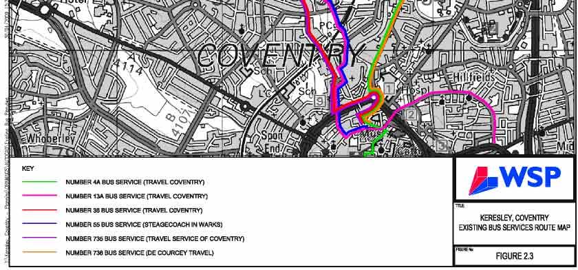
78

79
80

81

82
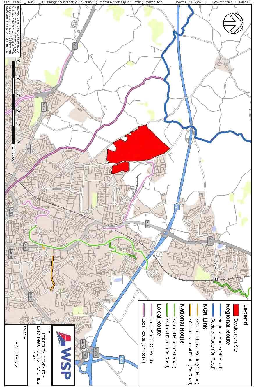
83
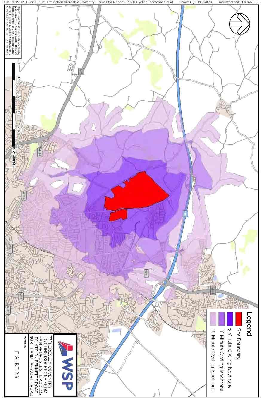
84
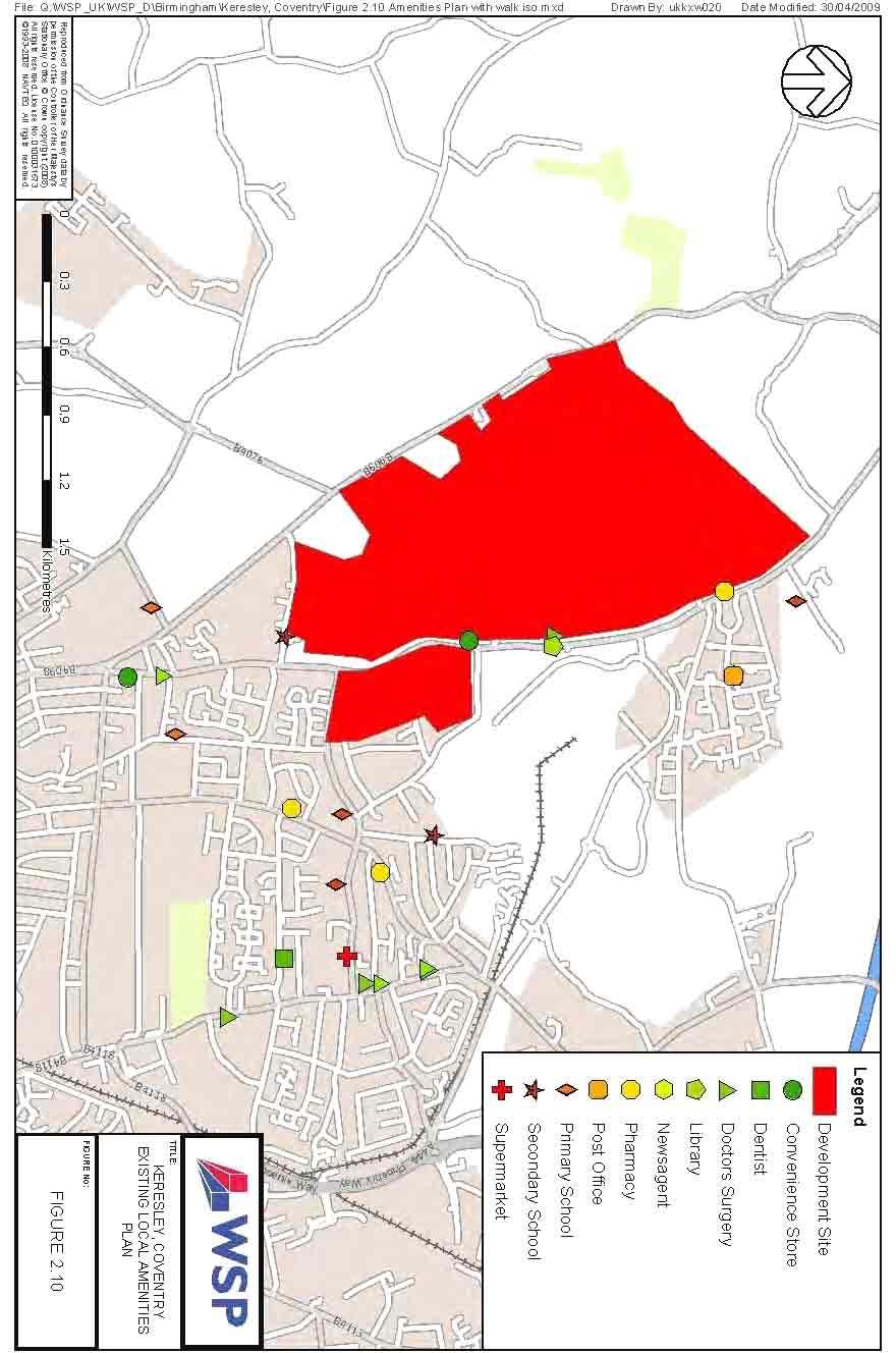
85

86
87

88
89 Keresley Sustainable Urban Extension Figure 4.1 Integrated Transport Strategy Modal Choice Diagram Journey Distance Walk Rail Service Hopper Bus Service Cycle Local Bus Service Rapid Transit Bus Service


90
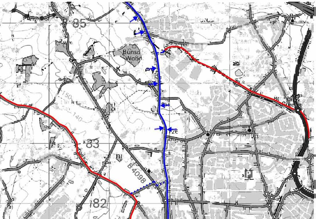

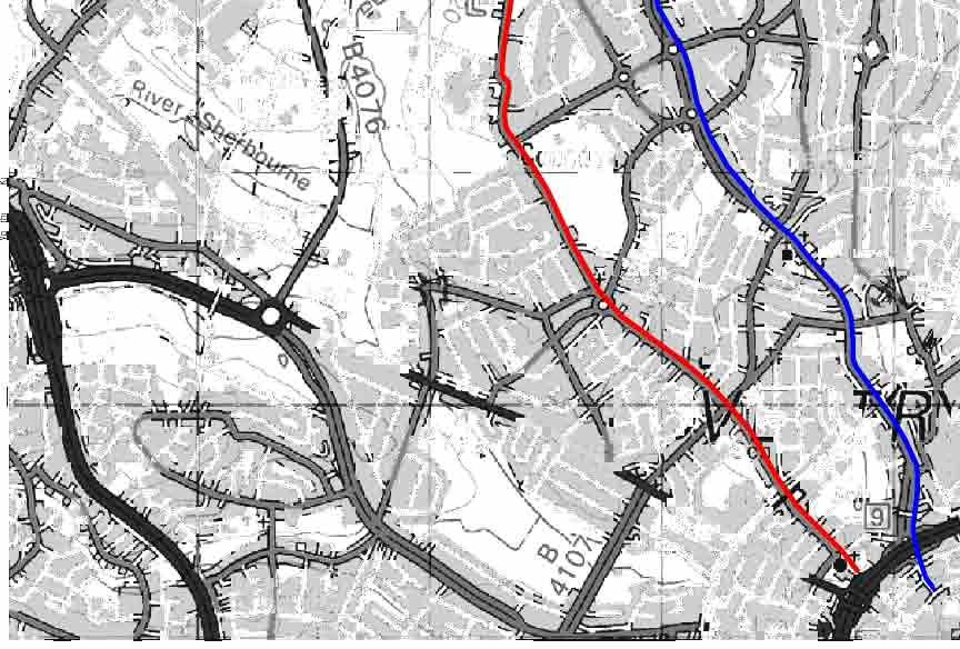

91

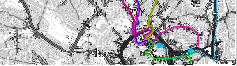

92

93
94 Keresley Sustainable Urban Extension Sustainable Transport Strategy The Queen s College, Oxford, Bluemark Developments Ltd and CALA Homes Midlands Ltd Final May 2009 WSP Development and Transportation One Queens Drive Birmingham West Midlands B5 4PJ Tel: +44 (0) Fax: +44 (0) WSP UK Limited Registered Address WSP House, 70 Chancery Lane, London, WC2A 1AF, UK Reg No England WSP Group plc Offices worldwide
95 Appendix A Pegasus Urban Design Drawing Bir.2588_20D
96 Gallagher Business Park Ricoh Arena B. D Medium density residential development Lower density residential development Very low density residential development set in woodland Existing urban area Existing employment areas T F Team MCC/EJT 27th April 2009 drwg. Bir.2588_20D I Client: Bluemark Developments Ltd, The Queen's College Oxford, CALA Homes (Midlands) Ltd I Infill lower density residential development Principal Open Space Existing woodland and hedgerows Potential street network Potential to re-route overhead powerlines partial underground through site Viewpoint and destination Existing schools Existing principal areas of open space Existing allotments District boundary 1. Mixed use area along Bennetts Road 2. Mixed use are to centre of development 3. Small mixed use area off Bennetts Road 4. Small mixed use area to enhance existing facilities A. Central Greenway with capacity for active recreation use B. Continuation of Greenway alongside Brook in existing area C. Tamworth Road Green D. Retained open land and landscape character with key viewpoint E. Linear greenspace along line of grounded powerlines; potential for allotments, community orchards etc F. Existing recreation ground G. Landscape buffers to ancient woodland and sensitive areas H. New woodland to protect landscape character to the north and to enhance existing woodland of Hall Yard Wood and Bunson's Wood Corley Services M6 Higher density residential development Bennetts Road Corley Keresley Newland Primary School Community hub mixed use areas (70% residential, 30% other uses) New Primary school 4. Keresley Newlands H. Proposed woodland Hall Yard Wood Thompsons Lane Bunsons Wood F. Fivefield Road D. G. 3. Prologis Park Pikehorre Wood G. E. Tamworth Road Watery Lane President Kennedy Secondary School 2. A. B. 1. C. Royal Court Hotel Golf Centre Bennetts Road Keresley Coundon Hall Park Recreation Ground Cardinal Newman Secondary School Copyright Pegasus Planning Group llp. Crown copyright. All rights reserved. Ordnance Survey Copyright Licence number I Promap Licence number Drawings prepared for planning application purposes and can be scaled (drawings are not to be used for construction or sales documents). Please refer to (client) for development design risk assessment documents. Pegasus Urban Design is part of Pegasus Planning Group LLP. Any queries to be reported to Pegasus for clarification. Land off Tamworth Road, N.W. Coventry - Indicative Framework Plan
97 Appendix B Information on the NUCKLE provided by Coventry City Council
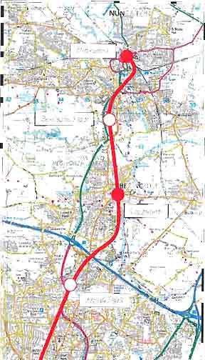


98
March Maidstone Integrated Transport Strategy Boxley Parish Council Briefing Note. Context. Author: Parish Clerk 2 March 2016
 Context. Author: Parish Clerk 2 The Draft Integrated Transport Policy (DITS) sets out a vision and objectives, and identifies a detailed programme of interventions to support the Maidstone Borough Local
TRANSPORT AND MOVEMENT
 TRANSPORT AND MOVEMENT Movement Strategy Public Transport Cycling and Walking Road Network Parking Standards Transport Impact Assessments Traffic Management Policies DRAFT POOLBEG PLANNING SCHEME Movement
Living Streets response to the Draft London Plan
 Living Streets response to the Draft London Plan Contents Living Streets response to the Draft London Plan... 1 About Living Streets... 2 Summary... 2 Consultation response... 3 Chapter 1: Planning London
1.5 On this basis it is fundamental that the Transport Strategy for the site focuses on the following key criteria,
 1.0 Introduction 1.1 The Transport Assessment has been prepared on behalf of Eon and Roger Bullivant Ltd in respect of the proposed mixed use sustainable urban extension of Drakelow Park. 1.2 The methodology
PERSONALISED TRAVEL PLANNING IN MIDLETON, COUNTY CORK
 PERSONALISED TRAVEL PLANNING IN MIDLETON, COUNTY CORK Elaine Brick Principal Transport Planner AECOM Abstract Smarter Travel funding was awarded to the Chartered Institute of Highways and Transportation
Speed Limit Policy Isle of Wight Council
 APPENDIX B Speed Limit Policy Isle of Wight Council 2009 Contents Section 1 Introduction 1.1 Links with the Local Transport Plan Section 2 Speed Limits on Urban Roads and Residential Areas 2.1 20mph Limits
9. Parking Supporting Statement
 9. Parking Supporting Statement Content 1. Setting the Scene 2. Vision 3. Parking and the Shared Priorities 4. Issues 5. Delivery Programme in the first Plan Period 2001/02 2005/06 6. Good Practice 7.
Douglas Land Use and Transportation Strategy (DLUTS) Summary. August 2013
 Summary. August 2013") Douglas Land Use and Transportation Strategy (DLUTS) Summary August 2013 Background Douglas is a large and popular residential suburb of approximately 30,000 persons on the periphery of Cork City along
Douglas Land Use and Transportation Strategy (DLUTS) Summary August 2013 Background Douglas is a large and popular residential suburb of approximately 30,000 persons on the periphery of Cork City along
Cycle network linking Wolverhampton city centre and Bilston town centre with employment sites and residential areas:
 Context and Problems Corridor length 12.3 km; Population within 800m 59,922; Jobs within 800m 59,100; Unemployment 11%; Average Index of Multiple Deprivation 46; Households with no car 45%; Proportion
Bristol City Council has produced a draft Bristol Transport Strategy document.
 Bristol Transport Strategy Summary Document Introduction Bristol City Council has produced a draft Bristol Transport Strategy document. The Strategy fills a gap in transport policy for Bristol. We have
London Cycle Network Annual Report 2000
 London Cycle Network Annual Report 2000 A cycle network for London by 2005 A cycle network for London by 2005 The London Cycle Network will: provide local links between residential neighbourhoods, railway
GD 0043/18 ACTIVE TRAVEL STRATEGY
 GD 0043/18 ACTIVE TRAVEL STRATEGY 2018-2021 May 2018 Minister s Introduction There is strong evidence that regular physical activity reduces the risk of a range of health conditions. The best way to increase
Nottingham Cycle City Frequently Asked Questions
 Nottingham Cycle City Frequently Asked Questions About the scheme How much money is to be spent on cycling? And where is the money from? We have 6.1 million in Growth Fund which we will be investing directly
Report to Cabinet. 18 May 2016
 Agenda Item 8 Report to Cabinet 18 May 2016 Subject: Presenting Cabinet Member: Proposed CCTV Enforcement of Traffic Contraventions in a Bus Lane (Key Decision Ref. No. HE030) Highways and Environment
Sandwell General Hospital Travel Plan 2014
 Sandwell General Hospital Travel Plan 2014 Travel Plan Survey Dated 24 th June 2013 Travel plan finalised March 2014 Prepared by Michael Raynor, JMP Consultants Ltd Site Address Lyndon, West Bromwich,
Chapter 7. Transportation. Transportation Road Network Plan Transit Cyclists Pedestrians Multi-Use and Equestrian Trails
 Chapter 7 Transportation Transportation Road Network Plan Transit Cyclists Pedestrians Multi-Use and Equestrian Trails 7.1 TRANSPORTATION BACKGROUND The District of Maple Ridge faces a number of unique
MILTON ROAD LLF PROJECT UPDATE
 Greater Cambridge City Deal MILTON ROAD LLF PROJECT UPDATE 9 th May 2017 Project objectives Comprehensive priority for buses in both directions wherever practicable; Additional capacity for sustainable
Active Travel Strategy Dumfries and Galloway
 Active Travel Strategy Dumfries and Galloway Our Active Travel Strategy The agreed Interventions for Dumfries and Galloway Council s Local Transport Strategy includes an action to Develop an Active Travel
Appendix N(b): Portishead Station Outline Travel Plan
: Portishead Station Outline Travel Plan") Portishead Branch Lane (MetroWest Phase 1): Environment Impact Assessment Appendix N(b): Portishead Station Outline Travel Plan Prepared for West of England Councils September 2017 1 The Square Temple
Portishead Branch Lane (MetroWest Phase 1): Environment Impact Assessment Appendix N(b): Portishead Station Outline Travel Plan Prepared for West of England Councils September 2017 1 The Square Temple
21.07 TRANSPORT CONNECTIVITY AND INFRASTRUCTURE
 21.07 TRANSPORT CONNECTIVITY AND INFRASTRUCTURE 21.07-1 Connectivity and Choice Transport connectivity and mode choice are critical to achieving productive, sustainable and socially just cities. Travel
Ormond & McKinnon Walks Response to Draft Glen Eira Community Plan
 Response to Draft Glen Eira Community Plan We would like to take this opportunity to thank Glen Eira City Council for the opportunity to comment on the Glen Eira Draft Community Plan. Below is an outline
Our journey a 20 year Transport Manifesto for the North East
 Our journey a 20 year Transport Manifesto for the North East Sustrans submission to North East Combined Authority (NECA). March 2016 Summary Sustrans is a leading UK charity enabling people to travel by
North West Non-Technical Summary of the Transport Assessment September 2011
 North West Non-Technical Summary of the Transport Assessment September 2011 Introduction This is a Non-Technical Summary of the findings of the Transport assessment work undertaken for the proposed North
IMPACT OF THE BERMUDA CONNECTIVITY PROJECT ON CYCLING
 IMPACT OF THE BERMUDA CONNECTIVITY PROJECT ON CYCLING BBAG BRIEFING NOTE EMAIL: BERMUDABRIDGEAGP@BTINTERNET.COM WWW.FACEBOOK.COM/GROUPS/BERMUDABRIDGEAG TWITTER @BERMUDABRIDGEAG CYCLING BBAG BRIEFING NOTE
2. Context. Existing framework. The context. The challenge. Transport Strategy
 Transport Strategy Providing quality connections Contents 1. Introduction 2. Context 3. Long-term direction 4. Three-year priorities 5. Strategy tree Wellington City Council July 2006 1. Introduction Wellington
APPELLANT S STATEMENT OF CASE
 TOWN & COUNTRY PLANNING ACT 1990 (AS AMENDED) APPEAL BY FOCUS INTERNATIONAL CHRISTIAN CENTRE (FICC) AGAINST REFUSAL OF PLANNING PERMISSION BY THE LONDON BOROUGH OF HILLINGDON PLANNING PERMISSION IS SOUGHT
Developing a Birmingham Transport Space Allocation policy. David Harris Transport Policy Manager Economy Directorate Birmingham City Council
 Developing a Birmingham Transport Space Allocation policy David Harris Transport Policy Manager Economy Directorate Birmingham City Council Birmingham s Sustainable Urban Mobility Plan Birmingham Connected
4 & 4A Oaklands Road, Bromley, BR1 3SL TRANSPORT ASSESSMENT
 4 & 4A Oaklands Road, Bromley, BR1 3SL TRANSPORT ASSESSMENT Oaklands January 2015 4 & 4A Oaklands Road, Bromley, BR1 3SL TRANSPORT ASSESSMENT Oaklands January 2015 Registered Company Address: Mansion House
Section 2 Strategic Alignment. Contents
 Section 2 Strategic Alignment Contents 2 Strategic Alignment... 2 2.1 General... 2 2.2 SmartGrowth Strategy and Implementation Plan... 2 2.3 Walking and Cycling Strategy... 3 2.4 Built Environment Strategy...
ABERDEEN: CITY OF THE FUTURE
 ABERDEEN: CITY OF THE FUTURE A contribution towards discussions on a future transport strategy for Aberdeen and its Region Prepared by the Centre for Transport Research University of Aberdeen June 2010
ENFIELD TOWN THE REVISED DESIGN
 TOWN THE REVISED DESIGN We re turning Enfield into a borough that encourages walking and cycling, a place that s easy for all of us to get around however we choose to travel. A greener place, with safer
Launceston's Transport Futures. Greater travel options for the people of Launceston
 Launceston's Transport Futures Greater travel options for the people of Launceston Final Draft 13 Jan 2014 1 Page Number Executive summary 3 What is Transport Futures? 4 Vision 6 Economy, access and liveability
Cycle traffic and the Strategic Road Network. Sandra Brown, Team Leader, Safer Roads- Design
 Cycle traffic and the Strategic Road Network Sandra Brown, Team Leader, Safer Roads- Design Highways England A Government owned Strategic Highways Company Department for Transport Road Investment Strategy
This objective implies that all population groups should find walking appealing, and that it is made easier for them to walk more on a daily basis.
 Walking for life The Norwegian Walking Strategy Guro Berge Norwegian public Roads Administration "Walking for life" is the slogan for the National Walking Strategy that is now being formulated in Norway.
Birmingham Connected. Edmund Salt. Transportation Policy Birmingham City Council
 Birmingham Connected Edmund Salt Transportation Policy Birmingham City Council www.birmingham.gov.uk/connected Birmingham Connected the story so far Broadly following EU Guidance We ve done all of this
Update June 2018 OUR 2017 PUBLIC ENGAGEMENT
 Update June 2018 Hi, Let s Get Wellington Moving (LGWM) is developing a Recommended Programme of Investment (RPI) that meets our programme objectives and supports the city s and region s growth. As part
Walking and Cycling Action Plan Summary. A Catalyst for Change The Regional Transport Strategy for the west of Scotland
 Walking and Cycling Action Plan Summary A Catalyst for Change The Regional Transport Strategy for the west of Scotland 2007-2021 Strathclyde Partnership for Transport Contents Purpose...2 Issues, Constraints
4.1 Introduction. 4.2 Aspects of walkable communities
 4 Community walkability Community walkability Making communities walkable Urban form Feeling secure 4.1 Introduction Walkability describes the extent to which the built environment is walking-friendly.
Transportation Master Plan Advisory Task Force
 Transportation Master Plan Advisory Task Force Network Alternatives & Phasing Strategy February 2016 BACKGROUND Table of Contents BACKGROUND Purpose & Introduction 2 Linking the TMP to Key Council Approved
Determining bicycle infrastructure preferences A case study of Dublin
 *Manuscript Click here to view linked References 1 Determining bicycle infrastructure preferences A case study of Dublin Brian Caulfield 1, Elaine Brick 2, Orla Thérèse McCarthy 1 1 Department of Civil,
CYCLING CHARTER ACTION PLAN EXECUTIVE SUMMARY
 CYCLING CHARTER ACTION PLAN EXECUTIVE SUMMARY THE VISION OF THE CYCLING CHARTER To realise the full potential of cycling s contribution to the health and wealth of the West Midlands creating more sustainable
Chelmsford City Growth Package
 Chelmsford City Growth Package Public Consultation Document Volume 2 West Chelmsford July - August 2017 Chelmsford City Growth Package Public Consultation Document - Volume 2 - West Chelmsford Contents
Your views are important. Please fill in a form before you leave. Or alternatively
 Drum Property Group is delighted to welcome you to this exhibition which sets out our initial proposals for a mixed-use development at Stead s Place, Edinburgh. We are keen to hear the views of local people
Exhibit 1 PLANNING COMMISSION AGENDA ITEM
 Exhibit 1 PLANNING COMMISSION AGENDA ITEM Project Name: Grand Junction Circulation Plan Grand Junction Complete Streets Policy Applicant: City of Grand Junction Representative: David Thornton Address:
IAN WHITE ASSOCIATES. Crawley Station Gateway Public Realm
 IAN WHITE ASSOCIATES Crawley Station Gateway Public Realm contents 1. objectives & client brief 2. site appraisal 3. best practice guidance 4. design concept 1. objectives & client brief Crawley Train
CITY OF VAUGHAN EXTRACT FROM COUNCIL MEETING MINUTES OF OCTOBER 30, 2012
 CITY OF VAUGHAN EXTRACT FROM COUNCIL MEETING MINUTES OF OCTOBER 30, 2012 Item 31, Report No. 39, of the Committee of the Whole, which was adopted without amendment by the Council of the City of Vaughan
The Cabinet Member for Highways & Streetscene. Aurang Zeb - Head of Highways & Transport
 LONDON BOROUGH OF RICHMOND UPON THAMES Cabinet Member Decision DATE: January 2012 REPORT OF: LEAD OFFICER: SUBJECT: WARDS: The Cabinet Member for Highways & Streetscene Aurang Zeb - Head of Highways &
Document History JOB NUMBER: DOCUMENT REF: REVISIONS: Revision Comments By Checked Authorised Date. Draft 1 Preliminary issue SA PS 15/5/2007
 Document History JOB NUMBER: DOCUMENT REF: REVISIONS: Revision Comments By Checked Authorised Date Draft 1 Preliminary issue SA PS 15/5/2007 PDF processed with CutePDF evaluation edition www.cutepdf.com
Final Plan 20 December 2016
 Final Plan 20 December 2016 Introduction Aims of the Travel Plan How do we travel? Understanding travel behaviours? The University Master Plan and its implications Galway City sustainable transport policies
A future cycle route network for North Staffordshire mb/08/16 Need for a strategy. Existing cycle route network
 Need for a strategy 1. The government s aim is to double cycling levels nationally by 2025 [note 1]. This would bring significant health, environmental, economic and traffic benefits [note 2]. It is widely
Warfield Neighbourhood Plan: 4.4 Infrastructure
 Warfield Neighbourhood Plan: 4.4 Infrastructure Previously decided Policy headings: Policy WNP16 Transport Impact of Development Policy WNP17 Transport Proposals Policy WNP18 New School Buildings Policy
CONNECTING PEOPLE TO PLACES
 CONNECTING PEOPLE TO PLACES 82 EAST BENCH MASTER PLAN 07 Introduction The East Bench transportation system is a collection of slow moving, treelined residential streets and major arteries that are the
Loughborough University Travel Planning
 Document Ti tle Client Name Loughborough University Travel Planning Loughborough University Travel Plan Executive Summary 2015-2020 23 December 2015 Loughborough University Travel Planning Project no:
Additional Policies & Objectives for Local Area Plans Ashbourne LAP. Ashbourne
 Ashbourne Strategic Policies SP 1 To operate an Order of Priority for the release of residential lands in compliance with the requirements of CS OBJ 6 of the County Development Plan as follows: i) The
Active Travel Towns Funding Scheme Project Proposal. Sligo. Sligo Local Authorities
 Active Travel Towns Funding Scheme 2014-2016 Project Proposal for Sligo by Sligo Local Authorities Introduction Over the last two years, Sligo Local Authorities have implemented years 1 & 2 of their 5
Design Workshops Summary of all Feedback January 2017
 Histon Road Corridor Design Workshops Summary of all Feedback January 2017 CITY DEAL AND GROWTH Commitment to Growth: Government, County, City and District Emerging Local Plans: 33,000 new homes 45,000
DRAFT for a State Policy for Healthy Spaces and Places
 DRAFT for a State Policy for Healthy Spaces and Places 1 DRAFT State Policy for Healthy spaces and Places 1. Purpose To encourage the use and development of land that builds healthy communities through
DESIGN CODE. Enterprise West Harlow London Road North Design Code 21
 DESIGN CODE Enterprise West Essex @ Harlow London Road North Design Code 21 4 MAXIMUM BUILDING HEIGHTS 4.1 Table 4A sets out maximum building height standards for each character area within the LDO boundary.
Document History. PDF processed with CutePDF evaluation edition JOB NUMBER: DOCUMENT REF: REVISIONS:
 Document History JOB NUMBER: DOCUMENT REF: REVISIONS: Revision Comments By Checked Authorised Date Draft 1 Preliminary issue SA PS 15/5/2007 Final Client Issue PS SA PS 24/9/07 PDF processed with CutePDF
Oxfordshire Local Transport Plan 4 Science Vale Cycle Network Project Proposal Didcot Ladygrove Link
 Overview of project: The Ladygrove Link will provide a modern, direct, off-road, active travel route from the new Didcot North East development and new leisure centre to the strategic Cow Lane Tunnel.
Phone: Ref No: 06/2018/0884
 Development Directorate Preston City Council Town Hall Lancaster Road Preston PR1 2RL FAO Ben Sandover Phone: 01772 533855 Email: david.allen@lancashire.gov.uk Ref No: 06/2018/0884 Date: 20 September 2018
The Ramsey Market Town Transport Strategy 26 th April 2010
 The Ramsey Market Town Transport Strategy 26 th April 2010 Contents INTRODUCTION 2 BACKGROUND 3 Strategy Area 4 Travel to, from and within Ramsey 5 Transport problems in the town 6 Links with other policies
University of Victoria Campus Cycling Plan Terms of Reference. 1.0 Project Description
 University of Victoria Campus Cycling Plan Terms of Reference 1.0 Project Description The Campus Cycling Plan, a first for the University, will provide a comprehensive and coordinated approach to support
21/02/2018. How Far is it Acceptable to Walk? Introduction. How Far is it Acceptable to Walk?
 21/2/218 Introduction Walking is an important mode of travel. How far people walk is factor in: Accessibility/ Sustainability. Allocating land in Local Plans. Determining planning applications. Previous
Public Consultation on Braintree Integrated Transport Package (ITP) HAVE YOUR. Consultation open from 24 September to 5 November 2018 SAY
 HAVE YOUR. Consultation open from 24 September to 5 November 2018 SAY") Public Consultation on Braintree Integrated Transport Package (ITP) HAVE YOUR SAY Consultation open from 24 September to 5 November 2018 Contents Introduction 3 Background 4 Springwood Drive Roundabout
Public Consultation on Braintree Integrated Transport Package (ITP) HAVE YOUR SAY Consultation open from 24 September to 5 November 2018 Contents Introduction 3 Background 4 Springwood Drive Roundabout
MARKHOUSE ROAD IMPROVEMENTS
 MARKHOUSE ROAD IMPROVEMENTS www.enjoywalthamforest.co.uk Waltham Forest is changing and we want you to be part of it. Thanks to a funding pot of 27million from Transport for London, we re delivering the
DON MILLS-EGLINTON Mobility Hub Profile
 Mobility Hub Profile Dundas Don Mills-Eglinton West-Bloor Anchor Hub Gateway Hub N MOBILITY HUBS: Places of connectivity between regional and rapid transit services, where different modes of transportation
Central London Bus Services Review
 Central London Bus Services Review Sustrans response to Transport for London November 2018 About Sustrans Sustrans is the charity making it easier for people to walk and cycle. We are engineers and educators,
Map 1 shows the two roads, and how they fit into the public transport network in and around Cambridge.
 Milton Road and Histon Road corridors bus priority infrastructure 1. Purpose The County Council would like to understand in more detail, the options to deliver the most effective corridor-based public
LEA BRIDGE ROAD - A STREET FOR EVERYONE Public consultation document
 LEA BRIDGE ROAD - A STREET FOR EVERYONE Public consultation document TELL US Bakers Arms to Leyton Green Road (Section D, E, F) Leyton Green Road to Whipps Cross Roundabout (Section G) YOUR VIEWS www.enjoywalthamforest.co.uk
High frequency bus services operating to Little Island; Creation of a new Park and Ride site and train station at North Esk;
 Cork County Council 7 th December 2018 Dear Adrian O Neill (aoneill@jbbarry.ie) The Transport and Mobility Forum, Cork (TMF) is a representative group of organisations who have a common interest in sustainable
E4 Cycle Route Exeter University to Redhayes Bridge. - Recommendations from Exeter Cycling Campaign
 E4 Cycle Route Exeter University to Redhayes Bridge - Recommendations from Exeter Cycling Campaign 1.0 Introduction Exeter Cycling Campaign has prepared this report to provide recommendations for Devon
Roads and public rights of way
 Roads and public rights of way This factsheet outlines how the effects of the Proposed Scheme on roads and public rights of way (PRoW) along the line of route would be managed. Version 1.0 Last updated:
DON MILLS-SHEPPARD Mobility Hub Profile
 DON MILLS-SHEPPARD Mobility Hub Profile Dundas Don Mills-Sheppard West-Bloor Anchor Hub Gateway Hub N MOBILITY HUBS: Places of connectivity between regional and rapid transit services, where different
I write in response to the current consultation. I am copying this to Derrick Ashley and I will be posting this online.
 Dear John Draft Local Transport Plan 2050 I write in response to the current consultation. I am copying this to Derrick Ashley and I will be posting this online. East Herts is a largely rural area, with
Westminster s Joint Health and Wellbeing Strategy
 Westminster s Joint Health and Wellbeing Strategy 2013 2016 Response from Sustrans General comments From a strategic perspective, Sustrans welcomes the Health and Wellbeing Strategy s focus on encouraging
NEWMARKET CENTRE Mobility Hub Profile
 Mobility Hub Profile Dundas Newmarket West-Bloor Centre Anchor Hub Gateway Hub N MOBILITY HUBS: Places of connectivity between regional and rapid transit services, where different modes of transportation
Transport Plan Adopted March 2012
 Burneside Parish Council Transport Plan Adopted March 2012 POLICY AREAS: TP1: Motor Vehicles TP2: Public Transport TP3: Cycling and Pedestrian Routes THE REPORT: 1. Scope of the Plan 2. Background 3. Local
Proposed Strategic Housing Development at the Former Doyle s Nursery and Garden Centre and Benoni, Brennanstown Road, Cabinteely, Dublin 18
 Proposed Strategic Housing Development at the Former Doyle s Nursery and Garden Centre and Benoni, Brennanstown Road, Cabinteely, Mobility Management Plan Quality information Prepared by Checked by Approved
Strategy for Walking & Cycling Action Plan
 Strategy for Walking & Cycling Action Plan To achieve higher levels of walking and cycling activity, the destinations which people access have to be available within suitable distances and designed to
ANNEX1 The investment required to achieve the Government s ambition to double cycling activity by 2025
 ANNEX1 The investment required to achieve the Government s ambition to double cycling activity by 2025 May 2016 About Sustrans Sustrans makes smarter travel choices possible, desirable and inevitable.
Welcome! Public Open House on UBC s Transportation Plan
 1 Welcome! Public Open House on UBC s Transportation Plan Public open house hours: to When it comes to on-campus transportation, what do you think is working well and what are some opportunities for improvement?
BELFAST RAPID TRANSIT. Ciarán de Búrca Director, Transport Projects Division Department for Regional Development
 BELFAST RAPID TRANSIT Ciarán de Búrca Director, Transport Projects Division Department for Regional Development Objectives of Belfast Rapid Transit To provide a modern, safe, efficient and high quality
Climate Change Action Plan: Transportation Sector Discussion Paper: Cycling
 Climate Change Action Plan: Transportation Sector Discussion Paper: Cycling ontario.ca/climatechange Contents 1. Minister of Transportation s message... 3 2. Introduction... 5 3. Sector Overview and Support
HAMILTON BIKING PLAN OUR VISION: A BIKE FRIENDLY CITY
 HAMILTON BIKING PLAN 2015-2045 OUR VISION: A BIKE FRIENDLY CITY INTRODUCTION Biking as a travel option is experiencing a resurgence internationally and in New Zealand, growing as a familyfriendly and healthy
Background. Caversham a vision for the future. Joint public meeting arranged by:
 Joint public meeting arranged by: Sharing our Streets Caversham a vision for the future and Caversham Traders Association This presentation followed a presentation by Simon Beasley, Network Manager for
What s the issue for transport in Cardiff?
 Demand for travel The number of commuters travelling to work in Cardiff has increased from 190,000 in 2001 to 198,000 in 2010, with some 124,000 Cardiff residents travelling across the city daily to their
BYRES ROAD: PUBLIC REALM Public Consultation
 Public Consultation Introduction As a vibrant commercial, shopping and residential location within the heart of the West End Byres Road is an important destination. Its proximity to the University of Glasgow
Douglas Land Use and Transportation Study
 Douglas Land Use and Transportation Study Summary: Key: Yellow Box = key project information Green Box = project recommendations Grey Box = anticipated project outcomes Background: It is an objective of
City of Wayzata Comprehensive Plan 2030 Transportation Chapter: Appendix A
 A1. Functional Classification Table A-1 illustrates the Metropolitan Council s detailed criteria established for the functional classification of roadways within the Twin Cities Metropolitan Area. Table
WEST YORKSHIRE LTP CYCLE PROSPECTUS
 WEST YORKSHIRE LTP CYCLE PROSPECTUS The West Yorkshire Ambition: To be recognised as a great place for safe cycling, inspiring more people to cycle more often. INTRODUCTION Cycling is low cost, environmentally
Harriet Fraser Traffic Engineering & Transportation Planning
 Appendix 5: Traffic Assessment 71 26 February 2015 Mr James Beban Senior Resource Consents Planner Cuttriss Consultants Ltd PO Box 30429 Lower Hutt PO Box 40170 Upper Hutt 5140 P 04 526 2979 M 027 668
Transport Assessment Haine Road Ramsgate CT12 5ET
 Haine Road Ramsgate CT12 5ET September 2016 39 Cossington Road Canterbury Kent CT1 3HU Tel 01227 472128 www.rmbconsultants.co.uk This report has been prepared by in accordance with the instructions of
Have your say on the transformation of Oxford Street West
 Have your say on the transformation of Oxford Street West About Living Streets We are Living Streets, the UK charity for everyday walking. We want to create a walking nation, free from congested roads
Pocatello Regional Transit Master Transit Plan Draft Recommendations
 Pocatello Regional Transit Master Transit Plan Draft Recommendations Presentation Outline 1. 2. 3. 4. What is the Master Transit Plan? An overview of the study Where Are We Today? Key take-aways from existing
Neighbourhood Development Plan: Ashtead INTRODUCTION 2 SUMMARY CONCLUSION CAR USE AND CONGESTION IN ASHTEAD 4
 CONTENTS Page INTRODUCTION 2 SUMMARY CONCLUSION 3 1.0 CAR USE AND CONGESTION IN ASHTEAD 4 1.1 Car Ownership and Methods of Travel to Work 4 1.2 Traffic Congestion in Ashtead 4 2.0 PARKING FACILITIES AND
A1307 Haverhill to Cambridge: Approval to consult on transport improvement concepts
 Report To: Greater Cambridge City Deal Executive Board 3 March 2016 Lead Officer: Graham Hughes, Executive Director of Economy, Transport and Environment, Cambridgeshire County Council A1307 Haverhill
City of Perth Cycle Plan 2029
 Bicycling Western Australia s response City of Perth Cycle Plan 2029 2012-2021 More People Cycling More Often ABOUT BICYCLING WESTERN AUSTRALIA Bicycling Western Australia is a community based, not-for-profit
Travel Plan Monitoring Report. Bourton View, Wellingborough - Residential
 Travel Plan Monitoring Report Bourton View, Wellingborough - Residential Prepared by: Developer Eyes Property and Estate Management, Broughton Grange Business Centre, Headlands, Kettering, Northants, NN15
How far do people walk?
 How far do people walk? Gareth Wakenshaw BSc (Hons), PGDip, MCIHT WYG Group Dr Nick Bunn BSc (Hons), MSc, PhD, MCIHT, CMILT WYG Group Presented at the PTRC Transport Practitioners Meeting London, July