Mapping Cyclist Activity and Injury Risk in a Network Combining Smartphone GPS Data and Bicycle Counts
|
|
|
- Herbert Sparks
- 5 years ago
- Views:
Transcription

1 Mapping Cyclist Activity and Injury Risk in a Network Combining Smartphone GPS Data and Bicycle Counts PhD Candidate: Jillian Strauss Supervisors: Luis Miranda-Moreno & Patrick Morency 25th CARSP Conference, Ottawa, Ontario, May 27-30, ème Conférence ACPSER, Ottawa, ON, mai 2015
2 Background A high number of cyclist injuries occur every year in cities Ex. Montreal 10 years from , 9,000 cyclists were injured 62% at intersections 38% along segments Given the importance of cyclist safety research has been carried out to identify risk factors and map risk in the network Such research requires 3 main sources of data: 1. Geo-coded injury data 2. Geometric design and built environment characteristics 3. Exposure measures cyclists and motor vehicles
3 Background In San Francisco Municipal Transportation Agency launched CycleTracks - Smartphone application In Georgia Tech launched Cycle Atlanta Smartphone application Both applications have 3 purposes: 1. Collect cyclist trip data see where cyclists are riding 2. Gauge current infrastructure 3. Guide future planning Based on these applications: In the city of Montreal developed their own smartphone application, Mon RésoVélo - to serve similar purposes
4 Objectives This study aims to: - Combine smartphone GPS traces and manual and automatic, short-term (hours) and long-term (months and years) counts to estimate: Average annual daily bicycle volumes Injuries Risk throughout the entire Montreal network of road segments and intersections
5 Methodology R iy iy 10 6 / 365 t i Z i
 Use buffer")
6 Methodology 1. Assign the GPS traces to the network elements Map all raw GPS observations (x,y) Use buffer approach to assign to segments and intersections 35 metres to capture most trips
7 Methodology 2. Obtain AADB volumes from short-term and long-term counts and develop an extrapolation function for the GPS data Compute AADB at manual count sites from permanent counter data Develop a function to associate this AADB with GPS flows: where: AADB ik = k T ik + k with k = f(x i ; ) AADB ik = average annual daily bicycle volume at location i of type k i= network element i of type k (signalized intersection, non-signalized intersection or segment) k = parameter weighing the number of GPS traces denoted as T i = correction factor associated with geometric design and/or built environment characteristics
8 Methodology 3. Validate the predicted AADB from GPS data through the development of Safety Performance Functions (SPF) Develop SPF models with both sources of bicycle flow data Compare parameter coefficients and variable significance 4. Apply the predicted AADB for segments and intersections for safety applications Map flows, injuries and risk throughout the entire network Identify hotspots
9 Data Bicycle Counts Smartphone GPS trips: Cyclist trip data from Mon RésoVelo smartphone application When cyclists begin their trip they start the app and upon arriving at their destination, they stop the app July 2 nd to November 15 th, 2013 (137 days) 1,000 cyclists 10,000 trips 16 million GPS points Short- and long-term bicycle counts: 8-hour manual counts at over 600 signalized intersections in hour manual counts at over 400 non-signalized intersections in 2012 Long-term counts along different road segments since 2008


10 Data - Injuries 6 years, , from ambulance interventions Over 5,000 cyclists injured at intersections Over 3,500 cyclists injured along segments Intersections Segments

11 AADB Models Results

12 Results AADB maps Intersections Segments
13 Results Variable AADB from manual counts AADB from GPS trips Coef. P-value Coef. P-value Ln* bicycle flow Ln* right turn motor-vehicle flow Ln* left turn motor-vehicle flow Crosswalk width Bus stop Raised median Constant Log-likelihood AIC * Ln = natural logarithm
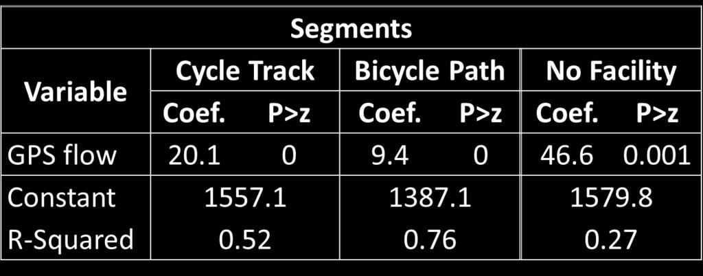
14 Segments Non-Signalized Intersections Signalized Intersections Results Variable Coef. Std. Err. P-value Ln* bicycle flow Bus stop Three approaches Constant Alpha AIC 5141 Observations (entire population) 2288 Ln* bicycle flow Arterial or collector Three approaches Constant Alpha AIC Observations (entire population) Ln* bicycle flow Arterial or collector Downtown boroughs Constant Alpha AIC Observations (entire population) 44314

15 Results Risk maps Intersections Segments

16 Results Intersections with and without arterials Signalized intersections Non-signalized intersections

17 Results Intersections with and without cycle tracks Signalized intersections Non-signalized intersections
18 Conclusion Explored the use of smartphone GPS data to estimate exposure measures for the entire network Validated for signalized intersections remains to be validated for non-signalized intersections and segments Mapped bicycle flows and risk in the entire network Can be used to identify hotspots and accounts for the entire population of sites Overall findings Cyclist risk is greatest outside the central neighbourhoods of the island which is also where infrastructure is lacking Cyclist injuries and risk are highest for intersections compared to segments
19 Questions? Thank you
MULTIMODAL INJURY RISK ANALYSIS OF ROAD USERS AT SIGNALIZED AND NON- SIGNALIZED INTERSECTIONS
 MULTIMODAL INJURY RISK ANALYSIS OF ROAD USERS AT SIGNALIZED AND NON- SIGNALIZED INTERSECTIONS PhD Candidate: Jillian Strauss Supervisor: Luis Miranda-Moreno 24th Canadian Multidisciplinary Road Safety
Video Analysis for Cyclist Safety: Case Studies in Montreal, Canada
 Video Analysis for Cyclist Safety: Case Studies in Montreal, Canada Bicycle infrastructure design and interplay in traffic OsloTech science park, Oslo Nicolas Saunier (Polytechnique), Sohail Zangenehpour
Safer Cycling: How the City of Vancouver is Proactively Improving Cycling Safety
 Safer Cycling: How the City of Vancouver is Proactively Improving Cycling Safety Brian Patterson, MCIP, RPP Urban Systems 2015 Canadian Association of Road Safety Professionals (CARSP) Conference Session
Cycling Volume Estimation Methods for Safety Analysis
 Cycling Volume Estimation Methods for Safety Analysis XI ICTCT extra Workshop in Vancouver, Canada Session: Methods and Simulation Date: March, 01 The Highway Safety Manual (HSM) documents many safety
Development of Decision Support Tools to Assess Pedestrian and Bicycle Safety: Development of Safety Performance Function
 Development of Decision Support Tools to Assess Pedestrian and Bicycle Safety: Development of Safety Performance Function Valerian Kwigizile, Jun Oh, Ron Van Houten, & Keneth Kwayu INTRODUCTION 2 OVERVIEW
Bike Counter Correlation
 Bike Counter Correlation A Story of Synergy: Bike Counts and Strava Metro For decades, transportation planners have used manual and automatic bicycle counters to collect hard data on where and when people
Are Signalized Intersections with Cycle Tracks Safer? A Case-Control Study Based on Automated Surrogate Safety Analysis using Video Data
 Are Signalized Intersections with Cycle Tracks Safer? A Case-Control Study Based on Automated Surrogate Safety Analysis using Video Data Sohail Zangenehpour, Ph.D. Candidate (Corresponding author) Department
Patrick Morency Medical advisor Direction de Santé Publique de Montréal. Catherine Morency Associate professor
 TRAVELING BY BUS INSTEAD OF CAR IN MONTREAL: SAFETY BENEFITS FOR VEHICLE OCCUPANTS AND PEDESTRIANS AND ITS ASSOCIATION WITH GEOMETRY Jillian Strauss Postdoctoral fellow École Polytechnique de Montréal
Welcome. If you have any questions or comments on the project, please contact:
 Welcome This drop-in public open house is intended to provide information about the Bay Street bike lanes project. This project proposes a dedicated cycling facility along Bay Street between Aberdeen Avenue
CYCLIST BEHAVIOR AT DISCONTINUITIES IN THE CYCLING NETWORK
 CYCLIST BEHAVIOR AT DISCONTINUITIES IN THE CYCLING NETWORK Matin S. Nabavi Niaki, École Polytechnique de Montréal Nicolas Saunier, École Polytechnique de Montréal Luis Miranda Moreno, McGill University
Traffic Parameter Methods for Surrogate Safety Comparative Study of Three Non-Intrusive Sensor Technologies
 Traffic Parameter Methods for Surrogate Safety Comparative Study of Three Non-Intrusive Sensor Technologies CARSP 2015 Collision Prediction and Prevention Approaches Joshua Stipancic 2/32 Acknowledgements
2.0 LANE WIDTHS GUIDELINE
 2.0 LANE WIDTHS GUIDELINE Road Engineering Design Guidelines Version 2.0.1 May 2018 City of Toronto, Transportation Services City of Toronto Page 0 Background In early 2014, Transportation Services initiated
Active Travel and Exposure to Air Pollution: Implications for Transportation and Land Use Planning
 Active Travel and Exposure to Air Pollution: Implications for Transportation and Land Use Planning Steve Hankey School of Public and International Affairs, Virginia Tech, 140 Otey Street, Blacksburg, VA
Driverless Vehicles Potential Influence on Bicyclist Facility Preferences
 Driverless Vehicles Potential Influence on Bicyclist Facility Preferences MICHAEL BLAU, MCRP, LCI O T E C O C T O B E R 2 6, 2 0 1 6 S E S S I O N # 8 2 - E V A L U AT I N G T H E P E R F O R M A N C E
Safety Effectiveness of Pedestrian Crossing Treatments
 Portland State University PDXScholar TREC Friday Seminar Series Transportation Research and Education Center (TREC) 10-13-2017 Safety Effectiveness of Pedestrian Crossing Treatments Christopher Monsere
Bike lanes for. Everyone
 Bike lanes for Everyone Goal: To increase the people riding bicycles as a normal part of every day life People riding bicycles as a normal part of every day life Regardless of age, gender, and social /
WINTER CYCLING: THE EXAMPLE OF MONTREAL
 WINTER CYCLING: THE EXAMPLE OF MONTREAL Mr. Marc-André Gadoury, City councillor, Official in charge of cycling for the administration of the Mayor of Montreal February 03, 2016 1. Introduction: Presentation
Vision Zero High Injury Network Methodology
 Vision Zero High Injury Network Methodology DATA SETS USED: 1. Reportable crashes in Philadelphia from 2012-2016, available as open data through PennDOT 2. Street Centerline geographic layer, maintained
2014/2015 BIKE ROUTE PLAN 83 AVENUE PROTECTED BIKE LANE
 About the Project 2014/2015 BIKE ROUTE PLAN The City of Edmonton is planning a major bike route on the south side of Edmonton. This bike route is one part of a plan to provide citizens with transportation
CITY OF SASKATOON COUNCIL POLICY
 ORIGIN/AUTHORITY Clause 1, Report No. 1-1980 and Clause 4, Report No. 22-1990 of the Works and Utilities Committee; Clause 6, Report No. 17-2004 of the Planning and Operations Committee; and Clause D5,
RURAL HIGHWAY SHOULDERS THAT ACCOMMODATE BICYCLE AND PEDESTRIAN USE (TxDOT Project ) June 7, Presented by: Karen Dixon, Ph.D., P.E.
 June 7, Presented by: Karen Dixon, Ph.D., P.E.") RURAL HIGHWAY SHOULDERS THAT ACCOMMODATE BICYCLE AND PEDESTRIAN USE (TxDOT Project 0-6840) June 7, 2016 Presented by: Karen Dixon, Ph.D., P.E., TTI Team: Kay Fitzpatrick, Raul Avelar, & Subasish Das Project
RURAL HIGHWAY SHOULDERS THAT ACCOMMODATE BICYCLE AND PEDESTRIAN USE (TxDOT Project 0-6840) June 7, 2016 Presented by: Karen Dixon, Ph.D., P.E., TTI Team: Kay Fitzpatrick, Raul Avelar, & Subasish Das Project
25th Avenue Road Diet Project A One Year Evaluation. Transportation Fund for Clean Air Project #05R07
 25th Avenue Road Diet Project A One Year Evaluation Transportation Fund for Clean Air Project #05R07 Submitted by: The San Francisco Municipal Transportation Agency Dan Provence May 22, 2009 EXECUTIVE
2014/2015 BIKE ROUTE PLAN 83 AVENUE PROTECTED BIKE LANE
 About the Project The City of Edmonton is planning a major bike route on the southside of Edmonton. The Strathcona Bike Route will connect the communities of Strathcona, Garneau and the University area,
NEIGHBOURHOOD TRAFFIC COMMITTEE POLICY AND PROCEDURE
 The City of Vaughan 2141 Major Mackenzie Drive Vaughan, Ontario Canada L6A 1T1 Tel (905) 832-2281 NEIGHBOURHOOD TRAFFIC COMMITTEE POLICY AND PROCEDURE REVISED JUNE 2010 APPLICABILITY The Neighbourhood
The Impact of Traffic Control Devices on Dangerous Pedestrian Crossings and Violations at Signalized Intersections: A Case Study in Montreal
 The Impact of Traffic Control Devices on Dangerous Pedestrian Crossings and Violations at Signalized Intersections: A Case Study in Montreal Nicolas Saunier, Luis Miranda-Moreno, Marilyne Brosseau, Sohail
Young Researchers Seminar 2011
 Young Researchers Seminar 2011 Young Researchers Seminar 2011 DTU, Denmark, 8 10 June, 2011 DTU, Denmark, June 8-10, 2011 Methods for assessing the pedestrian level of service: International experience
Bike Routes Assessment: 95 Ave, 106 St & 40 Ave. Replace with appropriate image in View > Master.
 Bike Routes Assessment: 95 Ave, 106 St & 40 Ave Replace with appropriate image in View > Master. Transportation Committee October 15, 2014 City Council Direction What we are trying to achieve The Way Ahead:
Downey Road. Transportation Improvement Study
 Downey Road Transportation Improvement Study Workshop 2 Participant Handbook Workshop 1 May 18 and 19, 2016 Workshop 2 June 23 and 28, 2016 Prepared By: City of Guelph Paradigm Transportation Solutions
Mobileye Shield+ Collision Avoidance System Pilot Program
 Information Item Date: August 16, 2017 To: From: Subject: Mayor and City Council Edward F. King, Director of Transit Services Mobileye Shield+ Collision Avoidance System Pilot Program Introduction Big
Prediction of Pedestrian Crashes at Midblock Crossing Areas using Site and Behavioral Characteristics Preliminary Findings
 Prediction of Pedestrian Crashes at Midblock Crossing Areas using Site and Behavioral Characteristics Preliminary Findings Timothy J. Gates, Ph.D., P.E. June 22, 2016 Pedestrian-Involved Crashes Pedestrian-Involved
Operational Ranking of Intersections: A Novel Prioritization Methodology
 Operational Ranking of Intersections: A Novel Prioritization Methodology Reza Omrani, Ph.D. Transportation Engineer CIMA+ 3027 Harvester Road, Suite 400 Burlington, ON L7N 3G7 Reza.Omrani@cima.ca Pedram
Appendix C. Corridor Spacing Research
 Appendix C. Corridor Spacing Research Task 3 of the Twin Cities Bicycle Study called for the development of bicycle corridor spacing guidelines. This section summarizes research of the spacing of planned
DOWNTOWN MIAMI PEDESTRIAN PRIORITY ZONE
 DOWNTOWN MIAMI PEDESTRIAN PRIORITY ZONE AUGUST 6, 2013 DOWNTOWN MIAMI BY THE NUMBERS more than 200,000 people live, work, and play here every day is home to more than 1,000 events each year hosts more
Implementing Complete Streets in Ottawa. Project Delivery Process and Tools Complete Streets Forum 2015 October 1, 2015
 Implementing Complete Streets in Ottawa October 1, 2015 The Essentials Complete Streets Implementation Framework will become part of the routine delivery of City transportation projects Approach uses every
HSM Practitioners Guide to Urban and Suburban Streets. Prediction of Crash Frequency for Suburban/Urban Streets
 HSM Practitioners Guide to Urban and Suburban Streets Prediction of Crash Frequency for Suburban/Urban Streets Predicting Crash Frequency of Suburban/Urban Multilane Streets Learning Outcomes: Describe
4/27/2016. Introduction
 EVALUATING THE SAFETY EFFECTS OF INTERSECTION SAFETY DEVICES AND MOBILE PHOTO ENFORCEMENT AT THE CITY OF EDMONTON Karim El Basyouny PhD., Laura Contini M.Sc. & Ran Li, M.Sc. City of Edmonton Office of
Peterborough Council on Aging
 Peterborough Council on Aging Discussion paper series #4, 2015 Transportation Transportation, including accessible and affordable public transport is a key factor influencing active aging. in particular,
Pedestrian Demand Modeling: Evaluating Pedestrian Risk Exposures
 Pedestrian Demand Modeling: Evaluating Pedestrian Risk Exposures Kelly J. Clifton National Center for Smart Growth University of Maryland May 19, 2008 Study Team University of Maryland National Center
CITY OF COCOA BEACH 2025 COMPREHENSIVE PLAN. Section VIII Mobility Element Goals, Objectives, and Policies
 CITY OF COCOA BEACH 2025 COMPREHENSIVE PLAN Section VIII Mobility Element Goals, Objectives, and Policies Adopted August 6, 2015 by Ordinance No. 1591 VIII MOBILITY ELEMENT Table of Contents Page Number
Deaths/injuries in motor vehicle crashes per million hours spent travelling, July 2007 June 2011 (All ages) Mode of travel
 Mode of travel") Cyclists CRASH STATISTICS FOR THE YEAR ENDED 31 DECEMBER 211 Prepared by the Ministry of Transport CRASH FACTSHEET 212 Cyclists have a number of risk factors that do not affect car drivers. The main risk
Cyclists CRASH STATISTICS FOR THE YEAR ENDED 31 DECEMBER 211 Prepared by the Ministry of Transport CRASH FACTSHEET 212 Cyclists have a number of risk factors that do not affect car drivers. The main risk
Copenhagen Cycling Map. Red Lines Cycling facilities
 Copenhagen Cycling Map Red Lines Cycling facilities Copenhagen Cycling Facilities Design Approaches Transportation without Pollution Copenhagen s Strategy Where Cycling is one of the top key activities
» Draft Recommendations» Discussion» Next Steps. Plan for Walking and Biking
 SAC Meeting Plan #3 for September Walking and 12, Biking 2018 » Draft Recommendations» Discussion» Next Steps Plan for Walking and Biking » Stakeholder and Public Outreach» Background data collection and
Canada s Capital Region Delegation to the Velo-City Global 2010 Conference
 Canada s Capital Region Delegation to the Velo-City Global 2010 Conference Report of Findings from Visits, Meetings & Presentations In Amsterdam-Den Haag, Utrecht, Berlin & Copenhagen The Itinerary Copenhagen
A Bicycle Network for a North American Metropolis: The Case of Montreal
 A Bicycle Network for a North American Metropolis: The Case of Montreal Marc Jolicoeur, Research Coordinator, Vélo Québec 1251 Rue Rachel Est, Montreal H2 J2J9, Canada marc-jolicoeur@velo.qb.ca Summary
NON-MOTORIZED TRANSPORTATION MONITORING PROGRAM
 NON-MOTORIZED TRANSPORTATION MONITORING PROGRAM Ohio Transportation Engineering Conference October 28 th, 2015 Presentation Content: Program Overview Manual Counts Automatic Counts Data storage Information
Estimating a Toronto Pedestrian Route Choice Model using Smartphone GPS Data. Gregory Lue
 Estimating a Toronto Pedestrian Route Choice Model using Smartphone GPS Data Gregory Lue Presentation Outline Introduction Background Data Smartphone Data Alternative Route Generation Choice Model Toronto
Addendum to Mitigated Negative Declaration
 Addendum Date: Case No.: 2014.1499E Project Title: (MDSP) - Mission Valencia Green Gateway Streetscape Project Original: 2008.1075, MDSP Mitigated Negative Declaration Project Sponsor: Charlie Ream, San
ACTIVE TRANSPORTATION
 Increasing ACTIVE TRANSPORTATION in Uxbridge Monday, September 21, 2015 Trudy Ledsham Suzanne Kershaw Surgeon General s Call to Action 50% of trips to Uxbridge High School are by car (DMG, TTS 2011) 2014
Designing a Bicycle and Pedestrian Count Program in Blacksburg, VA
 Designing a Bicycle and Pedestrian Count Program in Blacksburg, VA Steve Hankey (Virginia Tech) Andrew Mondschein (U or Virginia) Ralph Buehler (Virginia Tech) Issue/objective Issue No systematic traffic
Introduction 4/28/ th International Conference on Urban Traffic Safety April 25-28, 2016 EDMONTON, ALBERTA, CANADA
 4/28/2016 EVALUATING THE SAFETY EFFECTS OF INTERSECTION SAFETY DEVICES AND MOBILE PHOTO ENFORCEMENT AT THE CITY OF EDMONTON Karim El Basyouny PhD., Laura Contini M.Sc. & Ran Li, M.Sc. City of Edmonton
ADOT Statewide Bicycle and Pedestrian Program Summary of Phase IV Activities APPENDIX B PEDESTRIAN DEMAND INDEX
 ADOT Statewide Bicycle and Pedestrian Program Summary of Activities APPENDIX B PEDESTRIAN DEMAND INDEX May 24, 2009 Pedestrian Demand Index for State Highway Facilities Revised: May 29, 2007 Introduction
May 5, 2009 File:
 MMM Group Limited Suite 600 1455 West Georgia Street Vancouver, BC V6G 2T3 t: 604-685-9381 f: 604-683-8655 www.mmm.ca May 5, 2009 File: 50-09001-007 1420 1055 West Hastings Street Vancouver, BC V6E 2E9
APPENDIX D LEVEL OF TRAFFIC STRESS METHODOLOGY
 APPENDIX D LEVEL OF TRAFFIC STRESS METHODOLOGY 01 WHAT IS LEVEL OF TRAFFIC STRESS? When people bicycle on roadways, they encounter varying levels of stress from traffic. A quiet residential street with
ACCESSIBLE LOADING ZONES AND PROTECTED BIKE LANES: A UNIVERSAL DESIGN APPROACH. Accessibility Coalition Dec. 2016
 ACCESSIBLE LOADING ZONES AND PROTECTED BIKE LANES: A UNIVERSAL DESIGN APPROACH Accessibility Coalition Dec. 2016 A myth exists that only able-bodied individuals can ride bicycles. In reality, people with
The procedures to be followed in undertaking Non-Emergency work depend on the degree of traffic disruption caused by the work.
 APPENDIX G TRAFFIC CONTROL GUIDELINES FOR UTILITY WORK WITHIN ROADWAY RIGHTS- OF-WAY JUNE 2001 Scope of Guidelines These traffic control guidelines cover work performed by utility companies and/or their
Chapter 7. Transportation. Transportation Road Network Plan Transit Cyclists Pedestrians Multi-Use and Equestrian Trails
 Chapter 7 Transportation Transportation Road Network Plan Transit Cyclists Pedestrians Multi-Use and Equestrian Trails 7.1 TRANSPORTATION BACKGROUND The District of Maple Ridge faces a number of unique
Document 2 - City of Ottawa Pedestrian Crossover (PXO) Program
 Program") 40 Document 2 - City of Ottawa Pedestrian Crossover (PXO) Program OVERVIEW The City of Ottawa Pedestrian Crossover (PXO) Program provides the basis for PXO implementation in Ottawa. The program s processes
40 Document 2 - City of Ottawa Pedestrian Crossover (PXO) Program OVERVIEW The City of Ottawa Pedestrian Crossover (PXO) Program provides the basis for PXO implementation in Ottawa. The program s processes
WALKNBIKE DRAFT PLAN NASHVILLE, TENNESSEE EXECUTIVE SUMMARY NASHVILLE, TENNESSEE
 NASHVILLE, TENNESSEE EXECUTIVE SUMMARY Executive Summary A world-class multi-modal transportation system is essential to a vibrant city and better quality of life. -Mayor Barry The WalknBike plan aims
The Corporation of the City of Sarnia. School Crossing Guard Warrant Policy
 The Corporation of the City of Sarnia School Crossing Guard Warrant Policy Table of Contents Overview And Description... 2 Role of the School Crossing Guard... 2 Definition of a Designated School Crossing...
Anniedale- Tynehead NCP Best Practices in Transportation Planning Summary
 Anniedale- Tynehead NCP Best Practices in Transportation Planning Summary The City of Surrey Anniedale-Tynehead NCP Best Practices Transportation Summary This document provides a summary of the Bunt &
EXECUTIVE SUMMARY: TRANSIT-ORIENTED DEVELOPMENT IN SMITHS FALLS, ONTARIO; A COMPARISON BETWEEN TWO SITES
 EECUTIVE SUMMARY: TRANSIT-ORIENTED DEVELOPMENT IN SMITHS FALLS, ONTARIO; A COMPARISON BETWEEN TWO SITES Topic and Purpose In 2007, the Mayor of Ottawa s Task Force on Transportation suggested adding a
City of Ottawa s Complete Streets Approach to Transportation Projects
 City of Ottawa s Complete Streets Approach to Transportation Projects Presentation to Stakeholders Date: May 5, 2015 Presentation Overview Purpose of the study Proposed definition of Complete Streets for
City of Charlottesville Bicycle and Pedestrian Master Plan Update
 City of Charlottesville Bicycle and Pedestrian Master Plan Update September 17, 2014 I. Welcome and meeting overview II. Project status update III. Network overview IV. Break-out groups Pedestrian Network
Safety impacts of pedestrian crossing configurations and other features of signalized junctions on public transport routes
 Advancements in planning and operation of public transport Workshop 4.7.16, TRI, Technion Safety impacts of pedestrian crossing configurations and other features of signalized junctions on public transport
Oakville, Ontario Case Study
 Oakville, Ontario Case Study 1 Background The Town of Oakville, a suburb of Toronto, is located on the shore of Lake Ontario and has a population of about 185,000. Oakville created its first Active Transportation
8. Collisions INTRODUCTION
 8. Collisions INTRODUCTION While traffic collisions can affect anyone, they have a disproportionate impact on bicyclists, who along with pedestrians are the most vulnerable users of the transportation
Bicycle RSAs: How to Conduct Road Safety Audits and How to Use Them to Promote Bicyclist Safety. Dan Nabors, PE, VHB Bill DeSantis, PE, VHB
 PBIC Webinar Bicycle RSAs: How to Conduct Road Safety Audits and How to Use Them to Promote Bicyclist Safety [IMAGE] Dan Nabors, PE, VHB Bill DeSantis, PE, VHB Sept. 26, 2013, 2 pm Today s Presentation
Factors Associated with the Bicycle Commute Use of Newcomers: An analysis of the 70 largest U.S. Cities
 : An analysis of the 70 largest U.S. Cities Ryan J. Dann PhD Student, Urban Studies Portland State University May 2014 Newcomers and Bicycles Photo Credit: Daveena Tauber 2 Presentation Outline Introduction
Zlatko Krstulich, P.Eng. City of O9awa
 Zlatko Krstulich, P.Eng. City of O9awa 1. Introduction to the Ontario Traffic Manual Series 2. What is OTM Book 18: Bicycle Facilities? 3. Study / Committee Team Members 4. Brief overview of the content
Temporal and Spatial Variation in Non-motorized Traffic in Minneapolis: Some Preliminary Analyses
 Temporal and Spatial Variation in Non-motorized Traffic in Minneapolis: Some Preliminary Analyses Spencer Agnew, Jason Borah, Steve Hankey, Kristopher Hoff, Brad Utecht, Zhiyi Xu, Greg Lindsey Thanks to:
Cycling Network Plan Implementation in Thorncliffe Park and Flemingdon Park
 PW28.13 REPORT FOR ACTION Cycling Network Plan Implementation in Thorncliffe Park and Flemingdon Park Date: March 26, 2018 To: Public Works and Infrastructure Committee From: General Manager, Transportation
Relationship of Road Lane Width to Safety for Urban and Suburban Arterials
 Relationship of Road Lane Width to Safety for Urban and Suburban Arterials Phd. Alma AFEZOLLI Polytechnic University of Tirana Construction and Infrastructure Department of Civil Engineering Faculty Tirana,
Proposed Bridge Street East Bicycle Lanes Public Open House Thursday, April 27, 2017
 WELCOME Proposed Bridge Street East Bicycle Lanes Public Open House Thursday, April 27, 2017 Purpose of the Open House The purpose of this Open House is to gain public input on the bicycle lanes proposed
3 TRAFFIC CONTROL SIGNAL TIMING AND SYNCHRONIZATION
 Report No. 8 of the Transportation Services Committee Regional Council Meeting of October 20, 2011 3 TRAFFIC CONTROL SIGNAL TIMING AND SYNCHRONIZATION The Transportation Services Committee recommends:
Shifting Gears for a Healthier City.
 Shifting Gears for a Healthier City. Mississauga s Cycling Master Plan is an ambitious strategy that sets out to transform Mississauga into a city that is conducive to cycling for daily transportation
Northbound San Jose Avenue & I-280 Off-Ramp Road Diet Pilot Project
 Project Overview Fed by a two-lane Interstate-280 (I-280) off-ramp, high vehicular volumes and speeds are longstanding issues along San Jose Avenue. Residents in the surrounding neighborhoods have expressed
POLICY: TRAFFIC CALMING
 2006 MAY REFERENCE: COUNCIL APPROVED BY COUNCIL MAY 23, 2006 CITY OPERATIONS - NO. 608 POLICY: TRAFFIC CALMING A. All requests for traffic calming within the City shall be considered in accordance with
The Limassol SUMP Planning for a better future. Apostolos Bizakis Limassol, May 16, th Cyprus Sustainable Mobility and ITS conference
 The Limassol SUMP Planning for a better future Apostolos Bizakis Limassol, May 16, 2017 5 th Cyprus Sustainable Mobility and ITS conference Αbout Limassol Αbout Limassol The second largest city in Cyprus
Goodlettsville Bicycle and Pedestrian Plan Executive Summary
 Goodlettsville Bicycle and Pedestrian Plan July 2010 In Cooperation with the Nashville Area Metropolitan Planning Executive Organization Summary Introduction Progressive and forward thinking communities
Bicycle and Pedestrian Connectivity Study. Old Colony Planning Council
 Bicycle and Pedestrian Connectivity Study Old Colony Planning Council Outline Why consider bike/peds in road designs? Why are measures needed? Connecting Land Use with Transportation Evaluation Tools:
SURVEY: TRAFFIC VOLUME COUNT AUGUST 2017
 SURVEY: TRAFFIC VOLUME COUNT AUGUST 2017 Traffic Volume Counts The Survey for Traffic Volume Count was conducted by - itrans, PDA & CEE in Consortium, for Pune Cycle Plan. The Traffic Volume Count survey
Protected Bike Lanes in San Francisco Mike Sallaberry SFMTA NACTO Workshop - Chicago IL
 Protected Bike Lanes in San Francisco Mike Sallaberry SFMTA 10 14 2011 NACTO Workshop - Chicago IL San Francisco 2 nd Highest Density in the U.S. 47 square miles Mild Climate Market Population ~810,000
Look Up! Positioning-based Pedestrian Risk Awareness. Shubham Jain
 Look Up! Positioning-based Pedestrian Risk Awareness Shubham Jain Does this look familiar? Pedestrians account for 14% of all traffic fatalities in the US *. In the last decade, 688,000 pedestrians injured
10.0 CURB EXTENSIONS GUIDELINE
 10.0 CURB EXTENSIONS GUIDELINE Road Engineering Design Guidelines Version 1.0 March 2017 City of Toronto, Transportation Services City of Toronto Page 0 Background In early 2014, Transportation Services
For Information Only. Pedestrian Collisions (2011 to 2015) Resolution. Presented: Monday, Apr 18, Report Date Tuesday, Apr 05, 2016
 Resolution. Presented: Monday, Apr 18, Report Date Tuesday, Apr 05, 2016") Presented To: Operations Committee For Information Only Pedestrian Collisions (0 to 0) Presented: Monday, Apr 8, 06 Report Date Tuesday, Apr 0, 06 Type: Correspondence for Information Only Resolution For
Presented To: Operations Committee For Information Only Pedestrian Collisions (0 to 0) Presented: Monday, Apr 8, 06 Report Date Tuesday, Apr 0, 06 Type: Correspondence for Information Only Resolution For
Cycle Track Design Best Practices Cycle Track Sections
 Design Best Practices Sections It is along street segments where the separation and protection methods of cycle tracks offer more comfort than conventional bicycle lanes, and are more attractive to a wide
The link between built environment, pedestrian activity and pedestrian-vehicle collision occurrence at signalized intersections
 The link between built environment, pedestrian activity and pedestrian-vehicle collision occurrence at signalized intersections Luis F. Miranda-Moreno Assistant Professor Department of Civil Engineering
Dan Andrews. Expert Advisor to the Ontario Ministry of Tourism, Culture & Sport OPA Ed Conference, Burlington, ON March 1, 2018
 Dan Andrews Expert Advisor to the Ontario Ministry of Tourism, Culture & Sport OPA Ed Conference, Burlington, ON March 1, 2018 I Will Share With You Typical New User Experience Leading Towards Classification:
Pedestrians safety. ROAD SAFETY SEMINAR PIARC/AGEPAR/GRSP Lome, Togo October 2006 Lise Fournier, Canada-Qu
 Pedestrians safety ROAD SAFETY SEMINAR Lome, Togo October 2006 Lise Fournier, Canada-Qu Québec Contents WHO s data Risk factors Pedestrian needs Pedestrian facilities Conclusion Source: WHO WHO reports
Exploring the relationship between Strava cyclists and all cyclists*.
 Exploring the relationship between Strava cyclists and all cyclists*. Dr. David McArthur, Dr. Jinhyun Hong, Dr. Mark Livingston, Kirstie English *This presentation contains preliminary results which are
NCHRP Improved Prediction Models for Crash Types and Crash Severities. Raghavan Srinivasan UNC Highway Safety Research Center
 1 NCHRP 17-62 Improved Prediction Models for Crash Types and Crash Severities Raghavan Srinivasan UNC Highway Safety Research Center 2 The Project Team University of Connecticut Persaud & Lyon, Inc. University
MICROSCOPIC ROAD SAFETY COMPARISON BETWEEN CANADIAN AND SWEDISH ROUNDABOUT DRIVER BEHAVIOUR
 MICROSCOPIC ROAD SAFETY COMPARISON BETWEEN CANADIAN AND SWEDISH ROUNDABOUT DRIVER BEHAVIOUR Canadian Association of Road Safety Professionals Conference 2017 Paul St-Aubin, Ph.D. 1,2,3, Nicolas Saunier,
A Novel Approach to Evaluate Pedestrian Safety at Unsignalized Crossings using Trajectory Data
 A Novel Approach to Evaluate Pedestrian Safety at Unsignalized Crossings using Trajectory Data Ting Fu Supervisor: Luis Miranda-Moreno, Nicolas Saunier Ting FU Outline 1. Motivation & Literature Review
Introducing a Method for Planning a Safe Bicycle Network
 International Journal of Emerging Engineering Research and Technology Volume 6, Issue 9, 2018, PP 39-47 ISSN 2349-4395 (Print) & ISSN 2349-4409 (Online) Introducing a Method for Planning a Safe Bicycle
BICYCLE LEVEL OF SERVICE for URBAN STREETS. Prepared by Ben Matters and Mike Cechvala. 4/16/14 Page 1
 BICYCLE LEVEL OF SERVICE for URBAN STREETS Prepared by Ben Matters and Mike Cechvala 4/16/14 Page 1 Introduction The methodology used for the Bicycle (BLOS) analysis is from the Highway Capacity Manual
Strategic Plan for Active Mobility Phase I: Bicycle Mobility
 Strategic Plan for Active Mobility Phase I: Bicycle Mobility City of Corpus Christi February 9, 2016 Jeff Pollack, AICP Transportation Planning Director Vision Active Mobility Plan Vision The metropolitan
Bicycle Facilities Planning
 Bicycle Facilities Planning Overview Types of Cyclists Purpose for Riding Types of Facilities Bike Lanes Bicycle Boulevards Cycle Tracks Intersections Signals Signing and Marking Discussion Types of Bicyclists
Magnolia Place. Traffic Impact Analysis. Prepared for: City of San Mateo. Prepared by: Hexagon Transportation Consultants, Inc.
 Magnolia Place Traffic Impact Analysis Prepared for: City of San Mateo Prepared by: Hexagon Transportation Consultants, Inc. Updated January 4, 2010 Table of Contents 1. Introduction...1 2. Existing Conditions...6
4 DISRUPTION MANAGEMENT PLAN HIGHWAY 7 RAPIDWAY CONSTRUCTION BETWEEN BAYVIEW AVENUE AND WARDEN AVENUE TOWNS OF MARKHAM AND RICHMOND HILL
 4 DISRUPTION MANAGEMENT PLAN HIGHWAY 7 RAPIDWAY CONSTRUCTION BETWEEN BAYVIEW AVENUE AND WARDEN AVENUE TOWNS OF MARKHAM AND RICHMOND HILL The Transportation Services Committee recommends the adoption of
Chapter 5 DATA COLLECTION FOR TRANSPORTATION SAFETY STUDIES
 Chapter 5 DATA COLLECTION FOR TRANSPORTATION SAFETY STUDIES 5.1 PURPOSE (1) The purpose of the Traffic Safety Studies chapter is to provide guidance on the data collection requirements for conducting a