Road Investment Strategy PCF Stage 2 A27 East of Lewes. Report on Public Consultation
|
|
|
- Cathleen Harmon
- 5 years ago
- Views:
Transcription
1 Road Investment Strategy PCF Stage 2 A27 East of Lewes Report on Public Consultation April 2017
2 A27 East of Lewes Report on public consultation Table of contents 1 Executive summary Context Scheme background Report purpose Options presented Consultation arrangements Effectiveness of the public consultation Questionnaire response analysis Key stakeholder responses Conclusion 10 2 Introduction Scheme background Scheme objectives Public consultation objectives Purpose of this report Structure of this report 12 3 Consultation arrangements Proposed options Consultation events Publicising the consultation Stakeholder briefing Media engagement Online engagement Letters to residents Advertising campaign Information sites Other communication channels Social media Consultation material Consultation brochure and questionnaire Exhibition boards Technical reports and other documents Visualisations Effectiveness of the public consultation Exhibition attendance record Highways England website 18 ii
3 A27 East of Lewes Report on public consultation 4.3 Analysis methodology Data collection Methodology / database Distribution of responses Demographics of respondents compared to local population Consultation publicity Consultation effectiveness Period for comments Questionnaire response analysis Current problems and issues Options and proposals analysis Walking and cycling Selmeston Drusillas Wilmington Polegate Phasing and priorities Other comments Top tier stakeholder responses Stakeholder engagement Local authority responses Parish councils Statutory environmental bodies Local businesses and organisations Cycling and other active groups Residents groups Travel habits of consultees Additional issues Lessons learnt Emerging themes 46 9 Summary Questionnaire analysis Stakeholder response analysis Consultation effectiveness 49 Appendix A: Consultation brochure Appendix B: Consultation displays iii
4 A27 East of Lewes Report on public consultation Appendix C: Consultation questionnaire iv
5 1 Executive summary 1.1 Context Highways England s Project Control Framework sets out the methodology for delivery of a major highways scheme. The process is split into eight stages, of which this scheme is currently in Stage 2: Stage 0 (Strategy, Shaping and Prioritisation) problem definition, scheme requirements and strategic business case Stage 1 (Option Identification) option identification and sifting out of options that are likely to perform less well compared with others Stage 2 (Option Selection) detailed option assessment and selection of the Preferred Option, including detailed public consultation of the options Stage 3 (Preliminary Design) scheme development including design of the Preferred Option in sufficient detail to produce draft orders and preparation of the Environmental Assessment Stage 4 (Statutory Procedures and Powers) gaining authority to construct the scheme through the normal statutory processes as laid down in legislation Stage 5 (Construction Preparation) procurement of the construction contractor and detailed design of the scheme Stage 6 (Construction) construction of the scheme Stage 7 (Handover and Close-Out) project close out. In December 2014, the Department for Transport (DfT) published the Road Investment Strategy 1 (RIS1) for , which lists the schemes to be delivered by Highways England over this period. In response to the RIS announcement Highways England has developed their Delivery Plan (HE Delivery Plan ) which details how they will deliver the key strategic outcomes sought for RIS and measure success. The A27 East of Lewes is one of over 80 RIS schemes being progressed nationally as part of the delivery of the HE Delivery Plan Scheme background The A27 scheme extent between Lewes and Polegate is a corridor around nine miles (15km) long which runs through predominantly open rural areas. Lewes and Polegate are the main towns in the area, with smaller towns and villages including Beddingham, Firle, Glynde, Selmeston, Berwick and Wilmington. This stretch of the A27 suffers from congestion, delays and below average journey times, with some drivers diverting to unsuitable local roads. Polegate junction is a key pinch point and there are safety issues for pedestrians and cyclists. Accidents and incidents can cause long delays. The community and local businesses are suffering because of these longstanding issues. Traffic contributes to noise on the A27 and surrounding roads, and there are 12 noise important areas in the study area. A number of studies have been carried out on this section of road over the years including Highways England s recent A27 Corridor Feasibility study. From these we understand many stakeholders support plans for a major new bypass to the north of the A27. However this study, in keeping with Highways England Delivery Plan, is looking at a range of smaller measures focussed on providing short to medium term and sustainable transport improvements for the corridor. 5
6 Scheme objectives Smooth the flow of traffic by improving journey time reliability and reduce the average delay on the section of the A27 East of Lewes through small-scale interventions Support modes of travel and behaviours which minimise traffic and congestion. Support sustainable travel routes promoted by South Downs National Park Authority and East Sussex County Council Reduce annual collision frequency and severity ratio. Improve the safety and personal security of travellers along the section of A27 East of Lewes for all users and provide safer roads which are resilient to delay Reduce severance for local communities, including vulnerable road users, provide better access to local services and facilities, and improve access for local businesses along the corridor. Provide opportunities for improved accessibility for all users into the South Downs National Park Deliver a high standard of design for any improvement that reflects the character of the route and its setting alongside the South Downs National Park which is a nationally designated landscape of the highest quality; minimise impact on natural environment of new construction; and optimise environmental opportunities and mitigation Recognise some improvements will have an impact on the South Downs National Park, and have regard to the Special Qualities of the National Park in designing and evaluating improvement options. 1.2 Report purpose The purpose of this report is to provide a summary of the responses gathered during the non-statutory public consultation in The report details how the public were informed, how the options were presented, the responses received from members of the public, statutory stakeholders and other bodies, and how the responses have been analysed and considered. These responses will be used to help identify the Preferred Option and design requirements as the scheme approaches statutory consultation and Development Consent Order application (if applicable). 1.3 Options presented During the options identification process in Stage 1 (prior to the public consultation), Highways England consulted on numerous occasions with key stakeholders, public bodies and interest groups to hear their views about which sections should be developed. These stakeholders included: The A27 Reference Group, which represents broad local political interests including MPs and businesses South Downs National Park Authority Statutory environmental bodies East Sussex County Council, Eastbourne Borough Council, and Wealden and Lewes district councils, among others. These meetings furthered the project team s understanding of key issues and sensitivities, and informed the development of the study objectives in advance of wider consultation. Based on these meetings and consideration of the design, traffic, economics and environmental impacts, a set of options were developed that addressed capacity, safety, sustainability and access issues, and offer localised benefits. 6
7 The following options for key intervention points on the corridor were presented at public consultation: Selmeston village - road section o o o Option 1 new bypass to the far south of Selmeston Option 2 new bypass close to Selmeston Option 6 upgrade to existing A27 through Selmeston Drusillas Roundabout o A single option providing a roundabout enlargement to improve traffic flows through the junction; provide suitable and convenient crossings; and improve safety. Wilmington junction o o Option 1 junction improvement with pedestrian island Option 2 junction improvement with pedestrian underpass Polegate junction o o o Option 10 junction improvement Option 12 junction improvement and railway bridge widening Option 13 junction improvement, railway bridge widening and A27 dual carriageway from Polegate to Cophall Roundabout Corridor-wide facilities for pedestrians, cyclists and other non-car users o o Upgrading current facilities between Glynde and Firle and providing a new pedestrian/cycle path between Firle and Polegate proposals for maintenance bays to be included as various locations on the corridor. Full details of the options presented at the public consultation are in Appendix B. 1.4 Consultation arrangements The six-week public consultation ran from 27 October to 8 December Ten events were held at venues near A27 East of Lewes scheme corridor for the public and stakeholders including local authorities, landowners and businesses. Around 80,000 letters of invitation to the exhibitions were sent to households nearby. Information was also available on Highways England website, and brochures and questionnaires were available from libraries and information points in the area. The scheme and consultation were announced in October 2016 in a DfT press release which covered a number of RIS schemes in the south east. Advertising was carried in the local press, and local media were invited to a briefing session on the first day of the first public exhibition (27 October 2016). The consultation material consisted of a consultation brochure and questionnaire, and exhibition boards and technical reports displayed at events. This material was also available on Highways England consultation webpage. 1.5 Effectiveness of the public consultation The survey included a question about the effectiveness of the consultation: 88% of respondents found the consultation materials useful or somewhat useful. 71% who attended a public exhibition found it useful or somewhat useful. 7
8 In total 1050 people attended the public consultation events. It is considered that the events were well attended. 1.6 Questionnaire response analysis A total of 1,140 questionnaires (paper and electronic) were received during the six-week consultation period. All responses have been analysed, and free-form responses have been grouped into key themes. The following key points can be noted from the questionnaire analysis: General concerns 78% are very concerned about road safety 74% are very concerned about accommodating extra traffic from future housing and economic development 70% are very concerned about congestion or delays at junctions. Walking and cycling shared use path In general, respondents either agreed or strongly agreed that the corridor walking and cycling route would provide a safer and more attractive/convenient route (59%) and crossing facilities (64%). However, 38% agreed or strongly agreed that the scheme would encourage more people to make trips on foot or by bike. Also, there were 110 comments reiterating the opinion that the walking and cycling scheme was unnecessary and 55 comments concerning the scheme s value for money. Selmeston In summary 37% preferred Option 1 off-line option and 26% preferred Option 4 Option 6, upgrade to existing A27 through Selmeston, and a do nothing option received a similar level of support, 13% and 12% respectively. Preferences varied depending on where respondents said they live. The free-form comments about Selmeston concerned value for money, the impact on the environment and road safety. Drusillas Nearly 50% of respondents either agreed or strongly agreed that improving the roundabout would help traffic flows through the junction. Around 45% of respondents felt the scheme provided suitable and convenient crossing facilities. 41% of respondents agreed or strongly agreed the scheme would improve safety at the junction. Wilmington Around 38% of consultees expressed a preference for Option 1, while Option 2 received a similar level of support. During the consultation period, an alternate option Option 1 Light was discussed with residents of Wilmington village. This option comprises a pegasus crossing, and interventions to reduce traffic speeds and promote a village environment. Polegate 57% of respondents preferred Option 13 scheme, while Option 12 was the least preferred option. Option 10 received 11% support, while 14% expressed a preference to do nothing and leave it as it is. The free-form comments regarding Polegate focused on lane arrangements and access to Brown Jack Avenue and Gainsborough Lane. Phasing and priorities Options have been ranked in order of importance according to consultees first and second preferences: 8
9 Polegate Selmeston Drusillas Wilmington Walking and cycle path 1.7 Key stakeholder responses In analysing responses stakeholders have been separated into four key groups Local authorities Parish councils Statutory environmental bodies Local businesses and organisations Local authorities In general, local authorities who responded support improvements at Drusillas and Polegate, with a clear preference for Option 13 at Polegate. There was also a consensus that proposals for Selmeston and Wilmington offer poor value for money. Parish councils Four parish councils responded. In general, they support the shared use path; expressed a desire for a bypass option at Selmeston; and supported an improvement at Wilmington. The parish councils did not comment on all options. Statutory environmental bodies South Downs National Park (SDNP) and Historic England responded expressing concerns over the impact of a bypass at Selmeston. Neither would support such a scheme. SDNP stated that as presented, the design of the junction proposals within the SDNP would have significant adverse impacts. They will call for better design lead solutions for mitigating these impacts on a case by case basis. Of the options at consultation, Wilmington Option 1 and Polegate options 10 and 12 were considered to have the least impact on landscape, access and visual impact. Historic England raised concerns over the impact of the proposed improvements at Wilmington and neither option was supported. The improvements at Drusillas and Polegate junctions are seen as sufficiently localised as to not impact the wider environment/landscape. The SDNP expressed support for the walking and cycling scheme, whilst raising concerns over certain limitations to the proposed design. Historic England considered that such a scheme would not impact the historic environment. Local businesses and organisations Responses from other groups were separated into local businesses, cycling and rambling groups, and residents associations. Local businesses tourist attractions along the route generally support the shared use path, while other businesses raised concerns over the demand for such a scheme. There was no clear consensus from business responses for a particular option at Selmeston and no support for Drusillas. Wilmington Option 1 was supported with some businesses specifying alternative proposals. Polegate Option 13 received the most support, and specific issues were raised about access to and from Stud Farm, Brown Jack Avenue and Gainsborough Lane. 9
10 Cycling and rambling groups gave unanimous support for the shared use path. Most groups made further suggestions to improve the proposals, including facilities for crossing the A27 and better linkages to other routes. Residents associations focused on suggesting alternatives at Wilmington, referred to elsewhere in this report as Option 1 Light. Limited comments were received regarding other locations. 1.8 Conclusion Generally, respondents indicated that the corridor walking and cycling scheme would offer a safer and more attractive route/crossing points for cyclists, and local cycle groups welcomed the scheme. Also, some respondents thought the scheme would encourage more trips on foot or by bike. However, some aspects of the scheme were seen as offering a disjointed solution. While there is a consensus amongst respondents for a bypass at Selmeston, there was also significant opposition from key stakeholders. Multiple local authorities cited poor value for money, and statutory environmental bodies fear significant impact on South Downs National Park. Respondents and key stakeholders support an improvement at Drusillas, although specific concerns were raised over lane use arrangements and provision for cyclists, pedestrians and horse riders. Options at Wilmington received no clear support, and concerns were raised over the impact to common land. A common alternative was proposed comprising a Pegasus crossing to restrict vehicle speeds and providing a village feel to this stretch of the A27. Polegate Option 13 received support, although concerns were raised over access to and from Brown Jack Avenue and Gainsborough Lane. 10
11 2 Introduction 2.1 Scheme background The A27 between Lewes and Polegate is around nine miles long (15km) and runs through predominantly open rural areas. Lewes and Polegate are the main towns in the area, with smaller towns and villages including Beddingham, Firle, Glynde, Selmeston, Berwick and Wilmington. This stretch of the A27 suffers from congestion, delays and below average journey times with some drivers diverting to unsuitable local roads. Polegate junction is a key pinch point and there are safety issues for pedestrians and cyclists. Accidents and incidents can cause long delays. The community and local businesses are suffering because of these long-standing issues. Traffic contributes to noise on the A27 and surrounding roads, and there are 12 noise important areas in the study area. A number of studies have been carried out over the years, and we understand many people would like to see a major new bypass to the north of the A27. However, this study is looking at a range of smaller measures providing short to medium term improvements to give the best value for money at this time. 2.2 Scheme objectives Smooth the flow of traffic by improving journey time reliability and reduce the average delay on the section of the A27 East of Lewes through small scale interventions Support modes of travel and behaviours which minimise traffic and congestion. Support sustainable travel routes promoted by South Downs National Park Authority and East Sussex County Council Reduce annual collision frequency and severity ratio. Improve the safety and personal security of travellers along the section of A27 East of Lewes for all users and provide safer roads which are resilient to delay Reduce severance for local communities, including vulnerable road users, provide better access to local services and facilities, and improve access for local business along the corridor. Provide opportunities for improved accessibility for all users into the South Downs National Park Deliver a high standard of design for any improvement that reflects the character of the route and its setting alongside the SDNP which is a nationally designated landscape of the highest quality; minimise impact on natural environment of new construction; and optimise environmental opportunities and mitigation Recognise some improvements will have an impact on the South Downs National Park, and have regard to the Special Qualities of the National Park in designing and evaluating improvement options. 2.3 Public consultation objectives Gather feedback from stakeholders and present as evidence and provide the project team with insight to help determine a preferred route Clearly understand, and where possible, resolve the concerns of high level stakeholders Measure the success of the consultation communications and feedback methods Ensure coordination within Highways England and other traffic authorities who may be planning or carrying out programme works nearby 11
12 Work with other projects in the programme to maximise stakeholder engagement where they will be interested in the whole range of South East Road Investment Programme schemes. 2.4 Purpose of this report This report presents a summary of: How the public were informed of the public consultation events How the options were presented at the public consultation The responses received from statutory stakeholders and the public during the consultation period How the responses were considered. The responses to the consultation will help to identify the Preferred Option and the design requirements that would need to be considered as the scheme progresses towards the statutory consultation and the DCO application (if applicable). 2.5 Structure of this report The remainder of this report is structured as follows: Consultation arrangements Effectiveness of the public consultation Questionnaire response analysis Top tier stakeholder responses Travel habits of consultees Additional issues Summary 12

13 3 Consultation arrangements 3.1 Proposed options A number of options have been prioritised to address capacity, safety, sustainability and access issues, and offer localised benefits. Following a review of issues and evidence, and in consultation with stakeholders, the following locations were considered: Selmeston section Drusillas Roundabout Wilmington junction Polegate junction Corridor-wide facilitate for pedestrians, cyclists and other non-car users. Optioneering took place during the options identification process to shortlist a number of schemes for consultation. These options are described in full on the following page. It should be noted that many other locations along the scheme section were considered as part of the scheme development. The locations were selected based on demand at the different junctions, potential solutions and the viability of the potential solutions. Figure 3-1 Scheme locations Before the public consultation, Highways England consulted on several occasions with a range of key stakeholders, public bodies and interest groups: The A27 Reference Group, which represents broad local political interests including MPs and businesses South Downs National Park Authority Statutory environmental bodies East Sussex County Council and other local bodies including Eastbourne Borough and Wealden and Lewes district councils. 13
14 A wider stakeholder consultation event was held in April 2016 to brief local stakeholders. These meetings furthered the project team s understanding of key issues and sensitivities, and informed the development of the study objectives in advance of wider consultation. After the initial screening of potential locations and aforementioned stakeholder engagement, a number of options emerged. These options were developed in terms of design, traffic and economics and environmental impacts. A summary of the different options is given below with detailed diagrams in Appendix B. Selmeston o o o Option 1 new bypass to the far south of Selmeston Option 2 new bypass close to Selmeston Option 6 upgrade to existing A27 through Selmeston Drusillas Roundabout o A single option providing a roundabout enlargement to improve traffic flows through the junction; provide suitable and convenient crossings; and improve safety. Wilmington junction o o Option 1 junction improvement with pedestrian island Option 2 junction improvement with pedestrian underpass Polegate junction o o o Option 10 junction improvement Option 12 junction improvement and railway bridge widening Option 13 junction improvement, railway bridge widening and A27 dual carriageway from Polegate to Cophall Roundabout Corridor-wide facilities for pedestrians, cyclists and other non-car users o Upgrading current facilities between Glynde and Firle and providing a new pedestrian/cycle path between Firle and Polegate. 3.2 Consultation events The public consultation took place over a six-week period from 27 October to 8 December 2016, giving the public an opportunity to express their views and opinions with respect to the scheme. The target audience for the consultation included any organisation or individual with an interest in the scheme. The exhibitions were hosted by the Highways England project team, including experts on modelling, traffic, economics and environment, to ensure queries raised during the consultation events could be properly addressed. The consultation included ten public exhibitions held at venues near the A27 East of Lewes scheme corridor. Table 3.1 summarises the schedule of public exhibitions held. 14
15 Table 3-1 List of public exhibitions Date Location Time Thursday 27 Oct Alciston & Selmeston Village Hall, BN26 6UG 11:30pm 7pm Friday 28 Oct Alciston & Selmeston Village Hall, BN26 6UG 11am 3pm Monday 31 Oct Civic Community Hall, BN27 2AX 11am 6pm Saturday 5 Nov Trinity Church, BN20 9QD 10am 2pm Wednesday 9 Nov Polegate Free Church, BN26 6AE 12pm 7pm Wednesday 16 Nov The William and Patricia Venton Centre, BN21 3QY 12pm 7pm Wednesday 23 Nov The William and Patricia Venton Centre, BN21 3QY 12pm 7pm Saturday 26 Nov Berwick Village Hall, BN26 6TD 10am 2pm Monday 28 Nov Lewes Town Council, BN7 2QS 12pm 7pm Tuesday 29 Nov Lewes Town Council, High Street, Lewes, BN7 2QS 12pm 7pm 3.3 Publicising the consultation In preparation for the consultation, Highways England implemented a targeted communications strategy to promote the consultation to local authorities, key stakeholders and the general public. All key activities are outlined in the sub-sections below Stakeholder briefing A stakeholder briefing was held on 27 October 2016 (12pm - 2pm) at Alciston and Selmeston Village Hall, BN26 6UG. This gave relevant parish and local councillors the opportunity to view and comment on the consultation material. Attendees were asked to complete the attendance sheet with their name and the region or parish they represented Media engagement A single press release was issued by Highways England encompassing a number of public consultations for road schemes across the south east. The press release is available at: A media briefing was held on 27 October 2016 ( pm) at Alciston and Selmeston Village Hall, BN26 6UG. This was an opportunity for the press to view the consultation material and ask questions of Highways England project managers Online engagement Details of the A27 East of Lewes improvement scheme were provided on Highways England website at The web page address was included in all information released into the public domain and provided: Scheme background Details of the public consultation (exhibitions, how to respond to the consultation and a link to the Citizen Space website featuring consultation material including electronic versions of the consultation brochure, questionnaire, technical appraisal report and environmental assessment report). The website went live on 27 October 2016 and included an registration system for users to receive updates about new information on the site Letters to residents Letters of invitation were distributed in advance of the consultation to approximately 80,000 residential properties in the vicinity of the A27 East of Lewes scheme corridor, containing full details of the public consultation. The area of coverage is shown in Figure

16 Figure 3-2 Map of letter drop distribution area Advertising campaign A full colour advertisement ran for two weeks in the Sussex Express and two weeks in the Eastbourne Herald in print and online editions. Posters were also displayed at key information points Information sites Consultation brochures and questionnaires were available during the consultation period from: East Sussex County Council Lewes Tourist Information Centre Eastbourne Tourist Information Centre Eastbourne Library Hailsham Library Denton Island Community Centre. Consultation posters were sent to community locations to inform the community about how they could take part in the consultation process Other communication channels These details were publicised for contacting the project team: info@highwaysengland.co.uk Telephone: Highways England Customer Contact Centre All responses received via the Customer Contact Centre during the consultation period were recorded and responded to by the Customer Contact and project teams. Highways England Customer Contact Centre received 100 queries. 16

17 3.3.8 Social media Although Highways England did not post information about the consultation on Facebook or Twitter, a number of organisations and individuals used these platforms to promote and share links about the consultation. Screenshots of example posts are shown below. Figure 3-3 Social media examples 3.4 Consultation material Consultation brochure and questionnaire A consultation brochure was produced with concise information about the project, including the scheme background, a summary of the options and their impacts and benefits. The consultation questionnaire was produced as a separate document and was also available in electronic format at Exhibition boards The public consultation exhibition boards presented key information about the scheme including objectives, background, options, results of assessments, the consultation process, and next stages including DCO process. A copy of the consultation boards is in Appendix B Technical reports and other documents The Technical Appraisal Report and Environmental Assessment Report were published on Highways England website Visualisations Visual representations of each of the proposed options were produced. These were run as a film on a continual loop and displayed on a television screen at each exhibition. 17
18 4 Effectiveness of the public consultation 4.1 Exhibition attendance record To record visitor numbers, attendees were asked to provide their name, address, postcode and organisation (if applicable). There were 1,050 visitors to the consultation exhibitions, as detailed below. Table 4-1 Date of event Public exhibition attendance Attendance Thursday 27 October (11:30pm 7pm): Alciston & Selmeston Village 74 Friday 28 October (11am 3pm): Alciston & Selmeston Village Hall 73 Monday 31 October (11am 6pm): Civic Community Hall, Hailsham 79 Saturday 5 November (10am 2pm): Trinity Church, Willingdon 176 Wednesday 9 November (12pm 7pm): Polegate Free Church 228 Wednesday 16 November (12pm 7pm): The William and Patricia Venton Centre, Eastbourne Wednesday 23 November (12pm 7pm): The William and Patricia Venton Centre, Eastbourne Saturday 26 November (10am 2pm): Berwick Village Hall 116 Monday 28 November (12pm 7pm): Lewes Town Council 72 Tuesday 29 November (12pm 7pm): Lewes Town Council 81 Total 1, Highways England website Visitor numbers to Highways England A27 East of Lewes improvement scheme project and consultation web pages were collected throughout the consultation period, as detailed in the table below. Table 4-2 Visitor numbers to scheme web pages during the consultation period Webpage A27 East of Lewes improvement scheme project page Total web hits Total unique visitors Average time on page mins 59 secs Consultation page mins 58 secs 4.3 Analysis methodology Data collection Questionnaire responses were received in hard copy (paper surveys and letters) and electronic form (online surveys and ). Hard copy responses were sent via a Freepost address or handed in at the exhibition events. Electronic responses were gathered via the website. A number of enquiries and submissions came via to the Customer Contact Centre. These were logged and responded to within a prescribed timeframe, and added to the master database of responses ready for analysis. 18

19 4.3.2 Methodology / database All responses were entered manually into a database and have been analysed to deliver qualitative and quantitative data in the form of charts, graphs, tables and text Distribution of responses A total of 1140 questionnaire responses were received during the consultation period, plus 100 responses via Highways England Customer Contact Centre. The majority of responses included a postal address (93%). Where an incomplete address was given, such as one without a postcode, the full address has determined through use of the Royal Mail postcode finder. Where relevant the responses have been analysed based on location. For example, responses to questions about Selmeston have been analysed to determine if the option preference is different between Selmeston residents and those who live further afield. The responses have been grouped based on areas according to parish boundaries. Outside of the core study area these boundaries have been grouped into larger areas as shown in Figure 4.1. It should be noted that parish area boundaries have been chosen because they match the locations of the key scheme components. The analysis should not be interpreted as the views of a particular parish council. Figure 4-1 Parish area boundaries Demographics of respondents compared to local population The questionnaire requested several pieces of information from respondents. Of key relevance is the age distribution of consultees. Young people were identified as a hard to reach group in the consultation plan, and this was considered in the development of the consultation exercise. Figure 4.2 below compares the age distribution of consultees against the local population (as taken from the 2011 census data). 19

20 The figure shows that, as expected, those under 44 engaged less in the consultation exercise. In total, 1080 questionnaire respondents gave their age. Figure 4-2 Age of respondents Consultation publicity Respondents were asked how they found out about the A27 East of Lewes scheme consultation. In total, 920 responses were received to this question. Figure 4.3 below shows the distribution of responses. The majority of respondents heard about the consultation from a letter through their door. Figure 4-3 Consultation publicity 20


21 4.3.6 Consultation effectiveness Respondents were asked about the usefulness of consultation materials and exhibition events responses were received regarding consultation materials and 1085 responses were received regarding the public exhibitions. Figures 4.4 and 4.5 show the distribution of these responses. In general the responses were positive. 88% of respondents found the consultation materials useful or somewhat useful. 41% of respondents found the public exhibitions useful or somewhat useful, while 42% of respondents did not attend a public exhibition. Assuming that the 5% who did not respond to the question did attend an exhibition, this translates to 71% of those who attended a public exhibition finding it useful or somewhat useful. Figure 4-4 Consultation materials Figure 4-5 Public exhibitions 4.4 Period for comments A six-week consultation period was provided to give time for the public and stakeholders to consider the proposals and comment. The closing date for feedback was midnight on 8 December 2016, which was made clear on all material published as part of the consultation. 21

22 5 Questionnaire response analysis This section focuses on all questionnaire responses. Analysis of the written contributions is in Section Current problems and issues In question 1, consultees were asked to say how concerned they were about particular existing issues on the A27, ranging from journey times through to environmental issues. Figure 5.1 below shows the distribution of responses to question 1. Figure 5-1 Current problems and issues The figure above shows the key concerns of 1111 responses: 78% are very concerned about road safety 74% are very concerned about accommodating extra traffic from future housing and economic development 70% are very concerned about congestion or delays at junctions. Respondents were least concerned about: 33% are very concerned about ease of access to properties and local facilities along the route 35% are very concerned about provision of footpaths, cycle paths and crossings. The concerns of consultees varied depending on their location. Where relevant, these varying concerns have been analysed in detail to allow conclusions to be drawn from the option analysis. Consultees were invited to give a free-form response to the question to highlight other concerns about the A27 they felt weren t covered by the question. In total, 589 free-form comments were received and analysed in line with key themes (summarised below). It can 22
23 be noted that many comments referred to more than one issue so the quantities below will exceed the total number of comments received. One-third of comments (196) expressed concern about traffic flow including congestion, journey times and slow moving farm vehicles. 187 comments (32%) referred to the need for a bypass or larger scheme. This was a common theme throughout the questions reflecting a long term aspiration of many in the local community for a dual carriageway bypass to the north of the current A27. See section 8.2 for further details. 150 comments (26%) considered road safety. 99 comments (17%) referred to walking and cycling. These were divided between positive comments supporting the need for more cycle lanes and negative comments calling for less focus on walking and cycling elements. 67 comments (11%) expressed concerns regarding the environment such as the need to consider the scheme s impact on the environment. 59 comments (10%) expressed concern over value for money offered by the proposed scheme. 57 comments (10%) referred to local economic or business growth. 54 comments (9%) stated that public transport improvements were necessary. 5.2 Options and proposals analysis The following sub-section summarises the comments received, via the consultation questionnaire, regarding each of the scheme components. The individual letters received have not been included in this analysis. The analysis for each scheme component reflects the question as presented in the questionnaire. For each question, consultees were invited to provide a free-form comment. These have been grouped into key themes. Where relevant, further analysis has been completed by cross referencing the option response against other questions from the questionnaire Walking and cycling For question two, participants were asked about the extent to which they believed the proposed walking and cycling path would lead to a number of specified outcomes. Figure 5.2 shows the extent to which consultees agreed or disagreed with particular statements regarding the shared use path. 23
 reiterated their response to the question by stating that the")
24 Figure 5-2 Shared use path response analysis Consultees were also invited to provide a free-form text response about the shared use path. In total, 382 free-form responses were given regarding the walking and cycling path, with key themes summarised thus: 110 comments (29%) reiterated their response to the question by stating that the walking and cycling scheme was not wanted/unnecessary. 64 comments (17%) made general design comments. These comments generally referred to the need for such a facility to be fully segregated from the road and of a sufficient standard. 55 comments (14%) expressed concern over the value for money of the scheme. 52 comments (14%) commented on the need for a bypass. This is a recurring theme in each of the questions. 46 comments (12%) expressed road safety concerns, such as the A27 being an unsafe road for cyclists Selmeston In question three, consultees were asked to indicate their preferred option for Selmeston, if an alternate option was preferable or if they thought nothing should be done. Figure 5.3 shows the preferences for each of the Selmeston options. Respondents preferred Option 1 (37%), a new bypass to the far south of Selmeston. 26% preferred Option 4, a new bypass close to Selmeston. Option 6, upgrade to existing A27 through Selmeston, and Do nothing received a similar level of support (around 12%). 24
25 Figure 5-3 Selmeston response analysis The preferences of consultees varied depending on the location of the respondent. The different locations can be found in section The following points can be noted: Respondents from Selmeston and Alciston and those located beyond the scheme extents showed a preference for Option 1. The least support for Option 1 was from residents living along the A27 between Lewes and Polegate (excluding those who live in Selmeston/Alciston, see table comment below). Table 5.1 below summarises the selections of the different locations. Table 5-1 Selmeston responses Area Option 1 Option 4 Option 6 Do Nothing Other No Response Selmeston & Alciston 38% 28% 13% 10% 7% 4% Scheme extents* 18% 26% 14% 23% 14% 5% External to scheme 42% 26% 12% 10% 7% 4% *This includes the other parish areas between (but excluding) Lewes and Polegate. Lewes and Polegate have been grouped in external to scheme reflecting the likely use of the extent of the A27 rather than more local movements. Selmeston and Alciston respondents are not included in this value. By cross-referencing the location of consultees, their key concerns for the A27 (as answered in question two) and their desire to see an option delivered at Selmeston (see section 5.2.6), the following can be noted. The key concerns of respondents from Selmeston, who ranked a Selmeston option as either first or second priority, were as follows: Road safety 94% of respondents either very or slightly concerned Ease of turning on to or off the A27 from local roads 94% of respondents either very or slightly concerned. The key concerns of consultees as a whole who ranked a Selmeston option as either first or second priority, were as follows: Road safety 82% of respondents either very or slightly concerned 25

26 Accommodating extra traffic from future housing and economic development 75% of respondents were either very or slightly concerned. This reflects the varying concerns of consultees along the length of the corridor. The free-form responses (of which there were 349) from question three have been analysed in detail and the following key points can be noted: 106 respondents assumed a bypass option would be delivered to a dual carriageway standard. The consultation documents clearly stated that both Options 1 and 4 would be delivered as a single carriageway 39% of respondents referred to the need for a dual carriageway bypass 18% of respondents were concerned about the value for money of the available options 16% of respondents referenced safety concerns 11% of respondents were concerned about the proposals impacts on the environment Drusillas The consultation presented one improvement option at Drusillas roundabout. In question four, consultees were asked about the extent to which the proposed option would address the issues at the junction (see Figure 5.4). Figure 5-4 Drusillas response analysis Consultees were also invited to provide further free-form comment on the proposal at Drusillas roundabout. The key themes from 369 comments are: Safety concerns 21% Design queries 18% Traffic flow 17% Request for a bypass 15% 26
27 Value for money 14% Design considerations 12% Do nothing 12% Reduce speed 7% Option alternatives 6%. The key area of concern in the responses was the lane arrangements of the proposed design, whereby two lanes were provided at the stop lane for each direction of the A27 but only one exit lane was available. Similar concerns were raised by many who attended exhibitions Wilmington In question five, consultees were asked which of the two Wilmington options they preferred, if an alternate option was preferable or if they thought nothing should be done (accompanied by a free-form text box). Figure 5.5 shows the results. Figure 5-5 Wilmington response analysis Approximately 38% of consultees expressed a preference for Option 1. Option 2 received a slightly lower level of support. During the consultation period, further engagement was carried out with residents from Wilmington village (1 December 2016). During this session an alternate option Option 1 Light was discussed, comprising a pegasus crossing and ideas to reduce the speed of traffic and provide a more village environment. Several consultees referred to this alternative by name. Key themes from 357 free-form responses were identified: 20% suggested option alternatives 57 comments (16%) expressed concern over the value for money of the scheme 42 comments (12%) expressed concerns about the impact on non-motorised users 39 comments (11%) referred again to the need for a bypass or larger scheme 27
28 5.2.5 Polegate 36 comments (10%) expressed safety concerns 11% commented on speed or speed limit 11% requested a Pegasus crossing 8% requested for a roundabout In question six, consultees were asked which of the three Polegate options they preferred, if an alternate option was preferable or if they thought nothing should be done. Figure 5.6 below shows the distribution of responses to this question. 57% preferred Option 13. Option 12 garnered least support. Option 10 received 11% support, but this was behind do nothing and leave it as it is with 14% of respondents opting for this option. Figure 5-6 Polegate response analysis In total, 379 free-form responses were received. The key theme with 142 comments (37%) was the need for a bypass/dual carriageway. This was commonly suggested as an alternative to the proposed option. Other key themes in the comments are summarised below: 108 (28%) commented on alternative schemes / scheme components, such as lane arrangements, signal arrangements, or access arrangements at Brown Jack Avenue and Gainsborough Lane. 74 comments (20%) referred to traffic flow, with around three-quarters expressing concern that the proposal would increase traffic levels. The remaining comments felt an improvement at Polegate would ease congestion. 53 comments (14%) reiterated their lack of support for an improvement at Polegate. 28

29 5.2.6 Phasing and priorities In question seven, consultees were asked to rank the different schemes in order of importance. Figure 5.7 shows how respondents ranked the different options. The feedback on the ranking of schemes will feature in the development of packages of schemes. Figure 5-7 Scheme component priorities From Figure 5.7 the following points can be noted: Improvements at Selmeston and Polegate were consistently ranked the highest Considering respondents first and second ranked options, the scheme components in order of preference were: o o o o o Polegate Selmeston Drusillas Wilmington Walking and cycle path Considering only the first ranked option of respondents, the scheme components in order of preference were: o o o o o Polegate Selmeston Walking and cycle path Wilmington Drusillas 29
30 5.2.7 Other comments Respondents were invited to make further comments in a free-form box. Key themes were identified from 612 comments: 370 comments (61%) referred to the need for a dual carriageway/bypass a common theme throughout free-form responses (Section 8.2 discusses this in more detail) 177 comments (29%) raised concerns about value for money 94 comments (15%) made general comments about the scheme design such as the need to improve right turns and issues with overtaking 80 comments (13%) expressed concern that the scheme would not address traffic flow issues on the A27 60 comments (10%) expressed concern that the scheme does not sufficiently address traffic on the A27 in respect of a future increase in housing or impact on the economy 58 comments (10%) expressed concern about infrastructure issues associated with the walking and cycling scheme being under-used 50 comments (8%) expressed concern about the lack of consideration of the impact of the proposals on the landscape. 30
31 6 Top tier stakeholder responses Most stakeholders responded via letter instead of questionnaire, with responses summarised according to four key groups: Local authorities Parish councils Statutory environmental bodies Local businesses and organisations Full copies of the responses are available. 6.1 Stakeholder engagement Numerous meetings were held with stakeholders during options development. A summary of key events: Stakeholder options input workshop (13/04/2016) Focus group meeting (12/10/2017) Key stakeholder briefing (27/10/2016) Media briefing (27/10/2016) East Sussex County Council (04/03/16) MP briefings (01/12/15 and 26/01/16) South Downs National Park (17/11/16) The stakeholder options input workshop (13/04/2016) was held so key stakeholders could share their views, agree objectives for the scheme and identify locations for improvements. Table 6.1 shows attendees and non-attendees is. MPs were unable to attend due to a diary change. Table 6-1 Stakeholder options input workshop 13/04/2016 Attendees Declined/unable to attend Alciston Parish Council Glynde & Beddingham Parish Cuckmere Valley Parish Council Council Alfriston Parish Council Glynde Estates Drusillas Association of Chamber of East Sussex Lewes District Council Environmental Agency Berwick Parish Council Natural England Historic England Coast to Capital LEP Selmeston Parish Council Member of Parliament, Brighton Cuckmere Valley Parish South Downs National Park Member of Parliament, Authority Eastbourne East Sussex County Council South East LEP Member of Parliament, Lewes East Sussex Police Sussex Safer Roads Partnership (SSRP) Natural England Eastbourne Borough Council Sustrans Network Rail Eastbourne Chamber of Commerce Wealden District Council Firle Estate Wootton Manor Firle Parish Council 6.2 Local authority responses No formal response was received from Lewes District Council, although one councillor responded in a personal capacity. Four local authorities responded and their responses are 31
32 summarised in the Tables 6.2 to 6.5 below. Table 6.6 provides a summary of the responses from the local authorities, with an indication as to their general support of each option. Wealden District Council East Sussex County Council Eastbourne Borough Council Polegate Town Council Table 6-2 Wealden District Council Respondents Summary of response from Wealden District Council Councillors Ann Newton, Raymond Shing and Stephen Shing Key concerns Severe congestion and delay Significant issues with journey time reliability Poor road safety record Key Improve connectivity objectives/hopes Deliver planned growth Benefit local communities Positives The proposed schemes could improve access to/from local villages and minor access roads along the A27 Negatives Smaller scale capacity improvements included in the consultation would appear to have little long term benefits The proposed schemes would not address delays and congestion experienced by longer distance traffic The need for infrastructure improvements to accommodate planned housing and employment growth in Wealden District. Reiterated the council s wider ambitions for a more comprehensive offline solution to the A27 East of Lewes ; and do not want wider pans compromised by small scale capacity improvements Walking and cycling Queried the need for the scheme and suggested further work to justify the scheme Selmeston No option supported due to poor value for money Drusillas Wilmington Polegate Support given for proposal Neither option supported due to loss of registered common land and poor value for money Support given for Option 13 with concerns over access to Stud Farm and suggested traffic lights are included. Table 6-3 Summary of response from East Sussex County Council East Sussex County Council Respondents Councillors Carl Maynard, Daniel Shing and Oi Lin Shing Key concerns Inconsistent road quality Poor road safety record Poor journey time reliability Key objectives/hopes Connectivity to the A23/M23 corridor, Gatwick airport, the M25 and beyond Improving journey time reliability for the movement of people and goods important for businesses and long distance traffic Accommodating planned and future growth as set out in Local Plans / emerging Local Plans, particularly for Eastbourne/South 32
33 Positives Wealden and Newhaven Greater resilience Long term aspirations for an offline dual carriageway. Currently working with A27 Working Group to develop evidence base n/a Negatives Would not want to see any of the short term interventions compromise the council s wider ambitions for an offline dual carriageway between Lewes and Polegate Proposed options would do little to improve long term traffic flow, suggesting that any gains made at junctions would be constrained by the single carriageway Walking and cycling More evidence of the need for this and the wider economic or health benefits would be required because overall value for money is poor Selmeston Council does not support any of option for Selmeston: poor value for money and both bypass options encroach on the South Downs National Park Drusillas Supports improvements to Drusillas to increase capacity as junction is a congestion hot spot Wilmington The council does not support either option for Wilmington, citing poor value for money. Cllr Shing made reference to the Wilmington working group proposal Polegate Supports for Option 13 with concerns over lack of right turn from Brown Jack Avenue. The design would need to ensure all current General scheme comments traffic movements are retained. Long construction periods (10-18 months) would increase delays during works Impact on South Downs National Park and the environment, and changes to the character of villages along A27 Single carriageway is dangerous for cycling Need to plan for population growth, e.g. new housing Table 6-4 Summary of response from Eastbourne Borough Council Eastbourne Borough Council Respondents Key concerns Key objectives/hopes Positives Councillor Robert Smart n/a n/a n/a Negatives Length of time for works to be complete (construction timetables exceeding 18 months / until 2022) Concern about how and whether the options fit into the larger proposed A27 scheme for which government funding has yet to be approved. Walking and cycling Poor value for money Selmeston Drusillas Wilmington Polegate General scheme comments Poor value for money Support due to very high value for money Poor value for money Support Option 13 due to very high value for money n/a 33
34 Table 6-5 Summary of response from Polegate Town Council Polegate Town Council Respondents Key concerns Key objectives/hopes Positives Negatives Walking and cycling Selmeston Drusillas Wilmington Polegate General scheme comments n/a n/a n/a n/a n/a The cycle path/footway is currently unsafe as the HGVs pass extremely fast, often resulting in debris being flicked onto the footpath. Is not a pleasant walking journey at all and not far enough away from the road to feel safe, whether by bicycle or foot. It is also not maintained in a satisfactory way to make it suitable. n/a n/a n/a Table 6-6 No option supported: Stud Farm estate (around 300 houses), near Polegate junction on south side of A27 Lewes Road only has two access points, Brow Jack Avenue and Gainsborough Lane; and both access roads have uncontrolled junctions with the A27. Because of traffic on A27 it is difficult to turn right from Brown Jack Ave or Gainsborough Lane, especially at peak. Concerned the proposed road layouts in all three options would make turning right from Brown Jack Avenue more difficult. Concerned the options do not include improvements to Gainsborough Lane junction Proposed junction layouts restrict access to and from the ESCC Highways Polegate Maintenance Depot (COLAS), as vehicles approaching the site from the east would not be able to right into the site from the A27. Many of the vehicles affected would be HGVs and would have forced to continue west toward Wilmington to turn around Regarding proposals to widen the railway bridge, the council suggests consideration of a short bypass road through the ESCC Highways Polegate Maintenance Depot (COLAS), to divert through traffic away from the A27/A2270 junction Concerned about access to / from three access points on the west side of the A27 between Polegate and Cophall roundabout, stating they are not insignificant and entrance and exit from all three is particularly difficult and risky Council-owned flower tubs located under licence on the islands should be restored and reinstated if any works are carried out. n/a Summary of response from Local Authority Organisation Walking Selmeston Drusillas Wilmington Polegate 34
35 & cycling Wealden District Council East Sussex County Council Eastbourne Borough Council Polegate Town Council Parish councils Responses were received from four parish councils listed below. Tables 6.7 to 6.10 summarise their responses, with a comparison given in Table Minimal interpretation has taken place and the summaries reflect the content/nature of the response received. Full copies of the responses are available. Arlington Parish Council Selmeston Parish Council Alciston Parish Willingdon and Jevington Parish Council Table 6-7 Arlington Parish Council Key concerns Key objectives/hopes Positives Negatives Walking and cycling Selmeston Drusillas Wilmington Polegate General scheme comments Summary of response from Arlington Parish Council n/a n/a Welcomes the proposals for improving road safety at junctions serving Arlington Parish Suggests that the road infrastructure may not meet future needs apropos the emerging Wealden Local Plan n/a n/a n/a n/a n/a n/a Table 6-8 Summary of response from Selmeston Parish Council Selmeston Parish Council Key concerns Access to/from the A27, particularly from The Street, Common Lane/Bopeep Lane and Alciston Village. Key objectives/hopes Positives Negatives Speeds along A27. Expressed opposition to a major new bypass to the north of Selmeston, responding to the wording within the consultation documents Expressed broad support for improvements at Wilmington, Polegate and Drusillas as well as to facilities for non-vehicular use Expressed concerns that the scheme comprises cherry picked elements rather than looking at the route as a whole 35
36 Walking and cycling n/a Selmeston Expressed almost unanimous support for a bypass option, with a slight preference for Option 4 over Option 1. Summary of concerns broadly relate to junctions and local access to/from any new bypass road, including 'access to Selmeston from the west by Middle Farm, the need for Bopeep Lane junction to act as main access to Selmeston and Berwick under the bypass options, Charleston junction, discouraging access routes from Arlington, The Dicker west via Common Lane Drusillas Wilmington Polegate General scheme comments Oppose Option 6 over concerns about speed of traffic on the improved sections of road approaching the village; and the abrupt change in quality between the new carriageway approaches to Selmeston and the existing junction would exacerbate current problems at the junction. Also, noted that problems might be resolved with traffic signals and said these could cause additional delays, as well as urbanising the village Generally concerned about vertical alignments and heights of embankments/cuttings Support changes to the Alciston Village junction Concerned the section between Middle Farm and Charleston turning is very dangerous because the road narrows and goes steeply downhill. Suggests a cycle path on this link would be useful. Reference made to a scheme suggestion they had previously submitted using a road alignment further south that better follows the natural contours of the landscape, and with less visual impact on the Downs and les adverse impact on properties. Improvements at Drusillas would be helpful but not deemed critical Proposals would alleviate problems with right turns. Expressed a preference for Option 1 mainly because they considered the ramps and subway at Option 2 to be disproportionate and have a negative impact on the Conservation Area and village green Generally supportive of the principle of investment at Polegate, but only in the context of a route-wide scheme. n/a Table 6-9 Summary of response from Alciston Parish Council Alciston Parish Council Key concerns The alignment of the A27 at the entrance to Selmeston village where the road has an acute bend (near petrol station, war memorial and pub) Key objectives/hopes Difficulties and delays turning onto A27 from village junctions Lack of resilience / poor journey time reliability on A27 in general and from accidents Acknowledged the need for highway improvements especially in view of planned future development and major growth around Hailsham and Polegate. Expressed overall support for a new offline dual carriageway to the north of Selmeston, enabling the 36
37 Positives Negatives Walking and cycling existing A27 to act as a local road serving the villages n/a n/a Support the continuous cycle path from Middle Farm to Polegate Selmeston Their response states that residents expressed most support for Option 4, followed by Option 1; but also expressed some reservations in case the new alignment could effectively determine the route of a future dual carriageway. However, this support for the bypass option came with concerns about road noise as the realigned carriageways would be nearer to Alciston village Drusillas Wilmington Polegate General scheme comments Suggested that relocating petrol station to the west may enable road realignment and widening, thus easing existing bottleneck and bend on A27 in Selmeston and improving road safety Strongly support proposed improvements to the Alciston village junction seen in all three options. Expressed concerns about heights of embankments and cuttings and consider 60mph speed limit too high. Suggested common sense measures such as banning right turns onto A27 from Common Lane, Bopeep Lane and Alciston, to improve safety. See below See below See below Expressed broad support for all safety improvements to the existing A27 without commenting specifically on the proposals at Drusillas, Wilmington and Polegate. Table 6-10 Summary of response from Willingdon & Jevington Parish Council Willingdon & Jevington Parish Council Key concerns Key objectives/hopes Positives Negatives Walking and cycling Selmeston Drusillas Wilmington Polegate n/a n/a Broadly supportive of all options, stating that the proposed alterations at Selmeston, Alciston, Drusillas and Wilmington are needed and it is hoped that this will improve the traffic and safety issues on this stretch of road. Offered comments on Polegate but did not comment on specific options or discuss schemes at Selmeston, Alciston, Drusillas and Wilmington. n/a n/a n/a n/a n/a Broadly supportive of an improvement scheme at Polegate and expressed concern about the considerable daily congestion along A2270 corridor at the A27/A2270 junction, and junction of A
38 General scheme comments with Wannock Road and Polegate High Street. On Polegate proposals, they support the option of widening the railway bridge to allow two lanes to be provided both north and south to Cophall Roundabout (Option 13), but raised these concerns: The proposed two lanes for the westbound A27 at the junction merging to one lane in a very short distance on the A27 Lewes Road is likely to cause conflict rather than free flowing traffic, suggesting the number of lanes in the proposed design be reviewed. The council notes that this conflict on the A27 westbound exists in the current road layout. They commented on the current operation of the junction suggesting that although there is a similar layout on the A2270 southbound exit, there is less conflict because most traffic in the offside lane turns right on to Wannock Road rather than merge with the nearside lane. There are strong concerns among residents living on the large estate to the south of the A27 Lewes Road about the difficulty they have when turning right from the estate on to the A27. The council noted from the proposals that vehicles from Brown Jack Avenue would only be able to turn west on to the A27 and that vehicles travelling in other directions would need to use Gainsborough Lane; and suggested the right turn from Gainsborough Lane would be much safer if islands are provided of the type proposed at Wilmington. n/a Table 6-11 Summary of responses from parish councils Organisation Walking & cycling Selmeston Wilmington Polegate Drusillas Arlington Parish Council Selmeston Parish Council Alciston Parish Council Willingdon & Jevington Parish Council - - * indicates a preferred option over another option that has also received support. 6.4 Statutory environmental bodies The South Downs National Park Authority provided a comprehensive response, as summarised below. Supporting evidence on landscape, access, visual impacts, biodiversity, archaeology/cultural heritage and ecosystems was provided. The environmental teams welcomed this information, which will feature in their analysis. The summary below focuses on landscape, access and visual impacts. Table 6-12 South Downs National Park Key concerns Key objectives/hopes Summary of response from South Downs National Park Protecting and conserving the landscape and character of the South Downs National Park. 38
39 Positives Negatives Walking and cycling Selmeston A recurring concern is the provision of pedestrian refuges to facilitate crossing the A27. Support the concept of an east-west non-motorised user route for walkers, cyclist and horse riders. But the overall impression is that nonmotorised users will be disadvantaged by the proposed schemes, with north/south access across the A27 severely impacted. Provision for non-motorised users is frequently on the northern side of the carriageway with few opportunities for users to access the South Downs National Park. There is an opportunity to improve connectivity for cyclists between Berwick railway station and Berwick village. However, the proposed improvements fail to address this issue and make no connection with either the existing promoted cycle route or the Vanguard Way long distance walking route. All Selmeston Options 1, 4 and 6 have unacceptable impacts on the special qualities of the National Park. The construction of a major trunk road around Selmeston would clearly trigger the major development test as set out in paragraph 116 of the NPPF All three options would involve significant vegetation loss, including hedgerows, tree-belts and parts of woodlands. Similarly, all options involve considerable earthworks, with the creation of cuttings and embankments to smooth out the vertical alignment of the A27 route. In particular, Routes 1 and 4 include proposals to dig a substantial cutting through Mill Hill (south-west of Selmeston), with an elevated section on its approach. All options include proposals to create an elevated section over the local valley between Selmeston and Alciston (albeit in different positions for each option, with differences in the proposed vertical elevations). In relation to Option 6, in order for these earthworks to be undertaken traffic would need to be taken away from the existing road and onto temporary construction roads stretching between Middle Farm and Molehill Shaw, and also on the tree-line incline to Selmeston from the west. The two bypass options would cause issues of severance, cutting across routes of current public rights of way. The on-line road improvement option has the advantage of not causing an increase in severance. Aside from the direct physical and landform effects of all three options for the route at Selmeston, each option would have implications for the wider landscape and visual amenity. Similarly, both bypass options would have significant implications for users of Bopeep Lane and Common Lane. All proposed routes fall within SSSI impact zones. The road improvement option with the least adverse landscape and visual, and access connectivity effects would be the Selmeston option 6 (on-line option) 39
40 Drusillas Wilmington Polegate General scheme comments As presented, the design of the junction proposals within the SDNP would have significant adverse impacts, so the SDNPA will on a case by case basis call for better design lead solutions for mitigating these impacts Direct physical implications for the landscape amenity, which would require clearance of some vegetation. It would expose nearby receptors to views of the highway, movement of vehicles across the scene and an increase in road noise. This would erode the tranquillity of the SDNP. At Wilmington, Option 1 has the least adverse landscape and visual, and access connectivity effects, but option 2 does offer some benefits. At Polegate, Options 10 and 12 have the least adverse landscape and visual, and access connectivity effects but not option 13. Urge HE to look more exhaustively at lower impact measures to address perceived problems of traffic flow and safety along the route without involving major new infrastructure within or adjacent to the National Park. SDNPA suggests possibility of maximising local benefit through HE Designated Funds (available separately). SDNPA consider information on Landscape impact, visually, tranquillity, accessibility Biodiversity Archaeological/Cultural heritage Transport modelling Economy Ecosystem Services No traffic modelling data has been given to them yet so further work would look to understand: The balance between local and through traffic and what that means both now and in the future The effects of changing traffic route patterns, mix of traffic (HGVs, car, bus etc.) and volumes on the local roads to and from SDNP, to assess whether these local road networks have sufficient capacity to accommodate changes and the effects on the communities through which they pass The impacts of traffic volumes at neighbouring pinch points at Lewes and around Polegate/Hailsham/Eastbourne, to understand the extent to which any potential journey time savings would be lost in increased waiting times elsewhere on the route. Table 6-13 Summary of response from Historic England Historic England Key concerns Key objectives/hopes Positives Negatives Walking and cycling n/a n/a n/a n/a Not considered to cause much harm to heritage assets, so the historic environment is unlikely to be the deciding factor in appraisal of options. 40
41 Selmeston Drusillas Wilmington Polegate General scheme comments They do not support either bypass option, citing damage to historic landscape character including risk of damage to archaeological assets caused by construction of bypass on undeveloped areas and impact from infrastructure such as noise, lighting and views. Consider Option 1 to have the most negative impact and Option 4, although the harm would be less due to the road being shorter, would also have a negative impact. Option 6 is considered not to cause major disruption or harm, but the online junction improvements and the small offline section near Alciston could still cause harm to the setting of nearby listed buildings. Historic England raises a specific concern that ground works or deep excavations would cause considerable harm to any undesignated archaeological remains. Considered likely to cause relatively little harm to heritage assets, so the historic environment is not likely to be the deciding factor in these options appraisals. They do not support either option, citing impacts on the rural and historic character of the area. Specifically concerned about: Significant new infrastructure that is not in keeping with the simple rural village setting Severe encroachment on existing grass verges and open spaces, including the historic Green Widening A27 would increase severance effect between either side of Wilmington Harm to the setting of the listed Crossways Hotel Given Wilmington s history, there is potential to harm undesignated assets namely the high potential that works disturb remains of the medieval settlement here Option 2 introduces all these impacts to a greater degree and will also disrupt the local network of trees and hedgerows. Deep excavations for a subway would increase the possibility of harming undesignated archaeological remains. Considered likely to cause relatively little harm to heritage assets such consider that the historic environment is not likely to be the deciding factor in these options appraisals. Recommends detailed heritage assessments, including consideration of known undesignated archaeology and assessing potential for disturbing unknown undesignated archaeology. Scope and methodology of assessments should follow published guidance on the setting of heritage assets (Historic England Good Practice in Planning Note 3) including effects on historic landscape character, and the settings of designated and non-designated heritage assets both within and outside the site boundary. 6.5 Local businesses and organisations Comments from other organisations were grouped into local businesses, cycling and other active groups and resident groups. Business 41
42 The business responses included travel companies that use the corridor, local tourist attractions along the route and Federation of Small Businesses (East Sussex Region), Eastbourne unlimited Chamber of Commerce and Folkington Estate. General General scheme comments from businesses focused on the need for a larger (dual carriageway) scheme to support local economic growth. Shared use path The response from businesses on the shared use path depended on the nature of the business. The Charleston Trust (a tourist attraction on the A27) supported the improvements but made suggestions of additional improvements that could be made. Other businesses were concerned over value for money due to the low demand. Folkington Estate also support the shared use path and expressed a preference for it to be fully segregated and made a comment regarding the maintenance. Selmeston Business responses did not typically specify a preferred option at Selmeston but instead reiterated their desire to see a dual carriageway bypass delivered. Charleston Trust specified a preference for Option 6 and suggested further improvements that could be made to accesses along the corridor. Folkington Estate preferred Option 4 as it balances the need to address local problems whilst minimising encroachment into the national park. Drusillas Of the business responses that commented on the improvement at Drusillas, there was an even split between support and negative comments. Again, the negative comments typically focused on the desire for a wider bypass option. Wilmington All four businesses that specified a preference between the schemes chose Option 1. Specified concerns were raised by the business owners local to the scheme. Folkington Estate opposed both options due to the required land take and impact on the local environment, and suggested an alternative comprising a small roundabout and a 40mph speed limit. Polegate Local businesses preferred Option 13 at Polegate. Specific concerns were raised over access to Gainsborough Lane, Stud Farm Estate and Honey Pot Farm. These comments were consistent with those raised by the public through the questionnaire Cycling and other active groups Six cycling clubs and two rambling groups responded to the consultation. The Campaign for Better Transport also submitted a comprehensive response to the consultation. General Cycling and rambling groups highlighted the severance impact of the A27 on local cycling and walking routes. Nearly all groups raised safety concerns over the current disjointed provision along the A27 corridor. Comments were received on the lack of easy access for walkers and cyclists to the South Downs National Park. The Campaign for Better Transport stated: We welcome the emphasis to connecting up pedestrian and cycle routes but these facilities need to be designed to the latest standards in order to realise their full potential, socially, environmentally and economically. Shared use path 42
43 Local cycling groups gave unanimous support, though most groups also highlighted the need for the scheme to be designed to a high standard. The rambling groups stated a the need for safe crossing points at all rights of way and other key areas. Additional improvements included: Improvements for non-motorised users on quiet side roads More convenient pedestrian and cycling crossings Better linkages to the north and south and across to the Cuckoo Trail. One group believe there is strong latent demand among people who want to get involved in more active travel but are put off by safety concerns and poor total-journey provision. Selmeston Responses from cycling and other active groups varied regarding a preferred option at Selmeston. Two groups expressed a preference for Option 6 due to concerns that a bypass option would increase traffic speeds and encourage more car traffic. One of the rambling groups chose Option 4 because of the balance between severance benefits whilst minimising the impact on the national park. The Campaign for Better Transport were strongly opposed to the bypass options due to the harm to the South Downs National Park and the increased severance of the rights of way network. Drusillas Of the groups that commented on Drusillas, all referred to concerns over the limited nature of the crossing facilities, preferring signalised crossing to the uncontrolled crossings that are currently proposed. The Campaign for Better Transport suggests a better at grade solution needs to be sought and stated the scheme presents a good opportunity to complete the link to Berwick Station. Wilmington Two of the groups specified a preference for Option 1, Campaign for Better Transport opposed Option 2 and the remaining groups did not state a preference. Specific concerns related to potential increases in speed and traffic flows increasing the risk to pedestrians and cyclists. The two groups who preferred Option 1 qualified their preference by stating the crossing should comprise traffic signals. Polegate None of the cycling and rambling groups specified a preference for any of the options at Polegate. Concerns were raised by two groups over the potential increase in traffic flows and speeds and the impact this would have on safety and the environment. Campaign for Better Transport opposed the option, stating the number of crossings required for pedestrians and cyclists was excessive Residents groups Five residents associations responded. Summaries of responses from local parish councils are shown earlier in this chapter. General Concerns were raised over the current impact to surrounding roads and villages when an accident closes the A27. One group believes the priority of the scheme should be to address safety issues. Two groups stated the scheme would not deliver a long-term solution, and one group suggested the money should be put towards a bypass. Shared use path Of the two groups that commented on the shared use path, both queried the demand for such a scheme. 43
44 Selmeston The only group that commented on the Selmeston options stated that a dual carriageway between Lewes and Eastbourne would be a preferred option. Drusillas The only group that commented on the proposed improvement at Drusillas roundabout felt that the current roundabout works reasonably well, implying that no change is needed. Wilmington Brief comments were received from two groups, one regarding the need to segregate pedestrians from vehicles and one suggesting the scheme should comprise a pelican crossing. Detailed responses were received from the Wilmington A27 Working Group and Wilmington Village Club. An alternative option was proposed comprising a small roundabout, a Pegasus crossing and a 40mph speed limit. Suggestion mitigation measures to provide more of a village environment included quiet road surfaces, addressing bumps and uneven manhole covers that cause noise and vibration. Polegate The only response regarding improvements at Polegate was from Willingdon Residents Association and stated that the access from Stud Farm/Gainsborough Lane is currently extremely dangerous and that the proposals do not appear to address the issue. 44

45 7 Travel habits of consultees Respondents were asked about their travel habits and how frequently they use the A27. The number of responses in the questionnaire varied by mode; on average 1043 responses were received to this question. Figure 7.1 shows that cars dominate. Figure 7-1 Travel habits of consultees 45
46 8 Additional issues This section summarises lessons learnt, key features of the questionnaire analysis and next steps for engaging with respondents to the consultation. 8.1 Lessons learnt Whilst the paper questionnaire provided a separate box for the respondent s address and postcode (allowing for easy analysis and encourage respondents to provide a postcode), the online questionnaire did not have a separate box for the postcode. This required additional processing of the questionnaire results as part of the postcode analysis. There were notable differences in how people responded to the questionnaire, depending on whether they were online or via pen and paper. In general, online responders were more likely to complete all questions. Certain questions, such as question 7 on scheme priorities, were responded to less effectively by those using pen and paper. This suggests the layout and instructions in the questionnaire could be refined. Residents at Wilmington were disappointed that an exhibition event was not organised for the village, so an event was set up during the consultation period. The contacts made will help us to engage further with them. 8.2 Emerging themes A recurring theme in consultation responses (and at consultation events) was the desire for a dual carriageway to the north of the current A27. The consultation material clearly stated that the A27 East of Lewes scheme was a separate scheme and in no way precluded the delivery of a larger bypass scheme in future. Following this non-statutory public consultation exercise, the Secretary of State for Transport, Chris Grayling, announced 3m of funds (to be taken from 75m available for the A27 East of Lewes scheme) would be dedicated to a full offline study into such a scheme 1. The exhibition boards showed summary business cases for each of the scheme components, including an analysis of value for money (benefit to cost ratio). Some consultees misinterpreted benefit to cost ratio and the weight given to value in the scheme assessment. Some Customer Care Centre logs requested further details on the benefit to cost ratio calculations. While the consultation material tried to convey this information concisely and clearly, the queries suggest that technical information could be simplified
47 9 Summary 9.1 Questionnaire analysis A total of 1140 questionnaires (paper and electronic) were received during the six-week consultation period. The questionnaire asked a total of 17 questions, with questions A1 A8 and B1 B4 considered key, and questions C1 C5 considered optional. A copy of the consultation questionnaire can be found in Appendix C. The electronic questionnaires were collected using Citizen Space, an online consultation platform. All responses have been analysed and grouped into themes, with the following key points noted: General concerns Key concerns of respondents: Road safety 78% very concerned Accommodating extra traffic from future housing and economic development 74% very concerned Congestion or delays at junctions 70% very concerned Walking and cycling shared use path In general, respondents either agreed or strongly agreed that the walking and cycling route would be a safer and more attractive/convenient route (59%) and crossing facilities (64%). Fewer people (38%) agreed or strongly agreed the scheme would encourage more people to make trips on foot or by bike. Numerous comments alluded to the lack of need for such a scheme and concern over value for money. Selmeston In summary 37% preferred Option 1, a new bypass to the far south of Selmeston 26% preferred Option 4, a new bypass close to Selmeston Option 6 (upgrade to existing A27 through Selmeston) and a Do nothing option received a similar level of support The preferences of consultees varied depending on the location of the respondent. The free-form comments regarding Selmeston focused on concerns over value for money, road safety and the impact on the environment. Drusillas Nearly 50% of respondents either agreed or strongly agreed that altering the roundabout would improve traffic flows through the junction. Around 45% of respondents felt the scheme would provide suitable and convenient crossing facilities. 41% agreed or strongly agreed that the scheme would improve safety at the junction. Wilmington Approximately 38% of consultees expressed a preference for Option 1. Option 2 received a similar level of support. At a separate meeting on 1 December 2016, Wilmington residents raised the idea of Option 1 Light, comprising a pegasus crossing and methods to reduce the traffic speed and create a village environment. Polegate 57% of respondents preferred Option 13. Option 12 garnered the least support. Option 10 received 11% support, while 14% opted to do nothing and leave it as it is. The free-form 47
48 comments regarding Polegate focused on lane arrangements and access to Brown Jack Avenue and Gainsborough Lane. Priorities Consultees were asked to rank the schemes in order of importance. Considering respondents first and second ranked options, the schemes components in order of preference were: Polegate Selmeston Drusillas Wilmington Walking and cycle path 9.2 Stakeholder response analysis Stakeholders have been separated into four key groups Local authorities Parish councils Statutory environmental bodies Local businesses and organisations Local authorities In general, local authorities who responded support improvements at Drusillas and Polegate, with a clear preference for Option 13 at Polegate. There was also a consensus that proposals for Selmeston and Wilmington offer poor value for money. Parish councils Four parish councils responded. In general, they support the shared use path; expressed a desire for a bypass option at Selmeston; and support an improvement at Wilmington. The parish councils did not comment on all options. Statutory environmental bodies South Downs National Park (SDNP) and Historic England responded, both of which expressed concern over the impact of a bypass at Selmeston. Neither would support such a scheme. SDNP stated that as presented, the design of the junction proposals within the SDNP would have significant adverse impacts. They will call for better design lead solutions for mitigating these impacts on a case by case basis. Of the options at consultation, Wilmington Option 1 and Polegate options 10 and 12 were considered to have the least impact on landscape, access and visual impact. Historic England raised concerns over the impact of the proposed improvements at Wilmington and neither option was supported. The improvements at Drusillas and Polegate are seen as sufficiently localised as to not impact the wider environment/landscape. The SDNP expressed support for the walking and cycling scheme, whilst raising concerns over certain limitations to the proposed design. Historic England considered that such a scheme would not impact the historic environment. Local businesses and organisations Responses from other groups were separated into local businesses, cycling and rambling groups, and residents associations. 48
49 Local businesses tourist attractions along the route generally support the shared use path, while other businesses raised concerns over the demand for such a scheme. There was no clear consensus from business responses for a particular option at Selmeston and no support for Drusillas. Wilmington Option 1 was support generally, with some businesses specifying alternative proposals. Polegate Option 13 received the most support, and specific issues were raised about access to and from Stud Farm, Brown Jack Avenue and Gainsborough Lane. Cycling and rambling groups gave unanimous support for the shared use path. Most groups made further suggestions to improve the proposals, including facilities for crossing the A27 and better linkages to other routes. Residents associations focused on suggesting alternatives at Wilmington, referred to elsewhere in this report as Option 1 Light. Limited comments were received regarding other locations. 9.3 Consultation effectiveness The following information was gleaned: 88% of respondents found the consultation materials useful or somewhat useful. 71% of those who attended a public exhibition found it useful or somewhat useful. 49
50 Appendix A: Consultation brochure 50
51 51
52 52
53 53
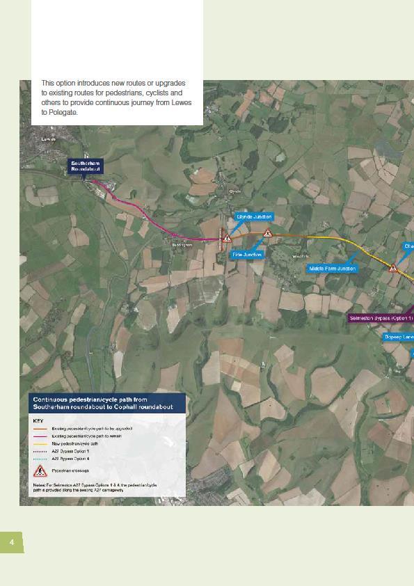


54 54
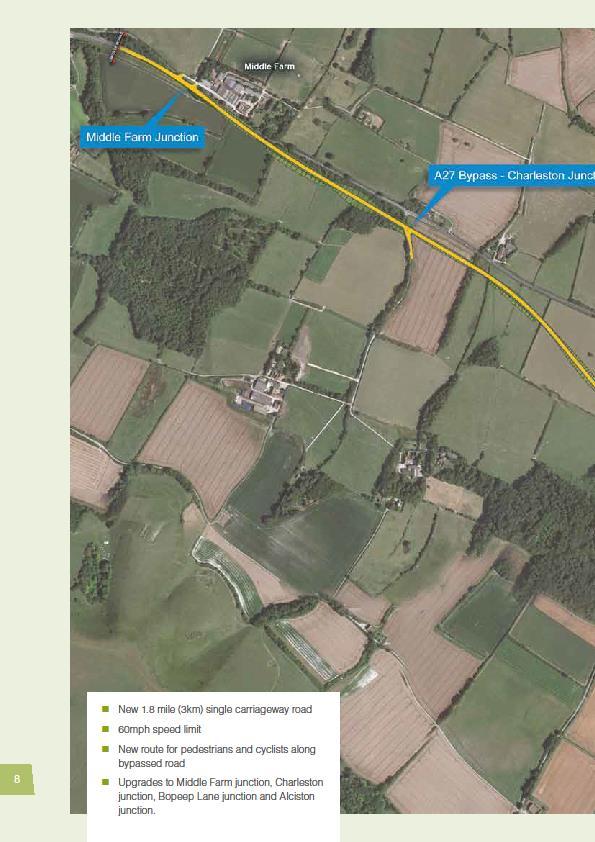


55 55
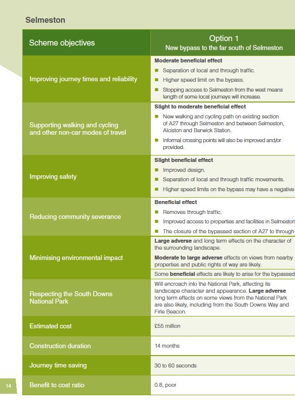

56 56
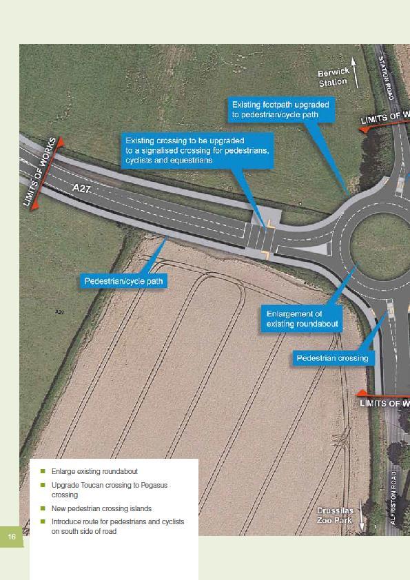


57 57
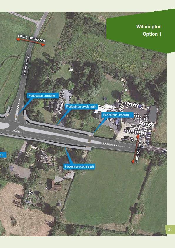

58 58


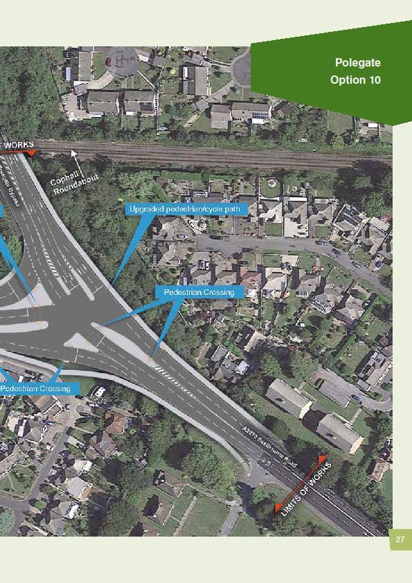
59 59
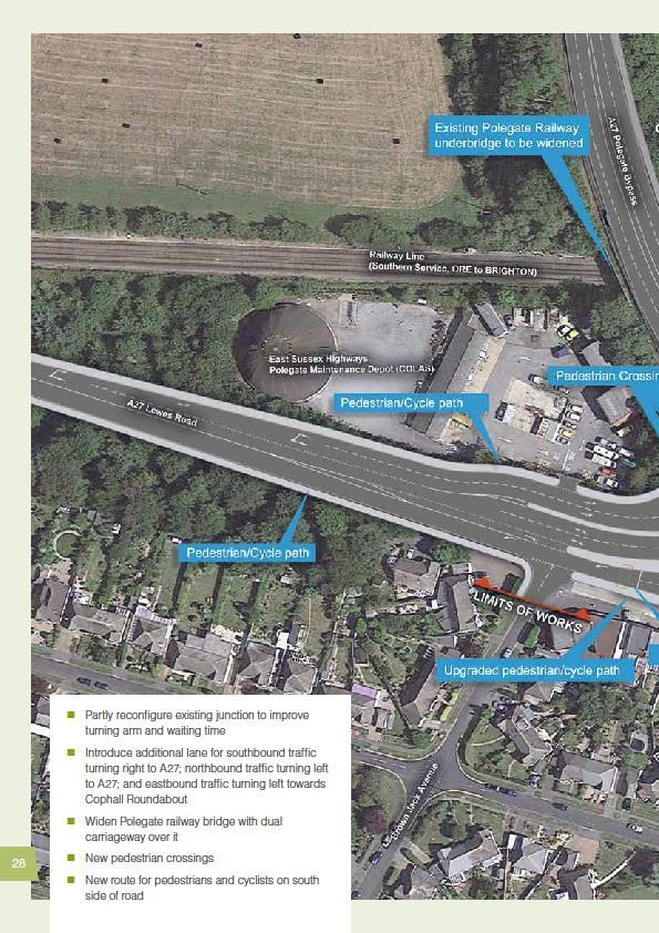


60 60
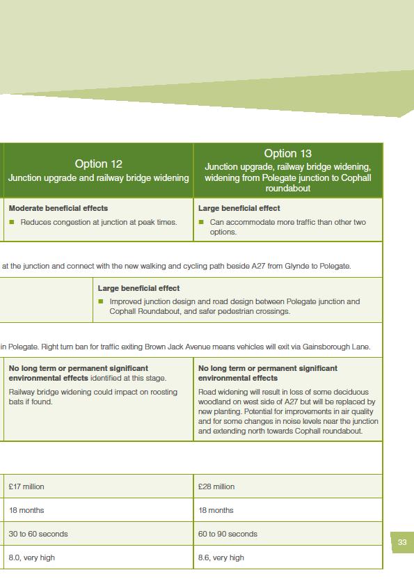


61 61


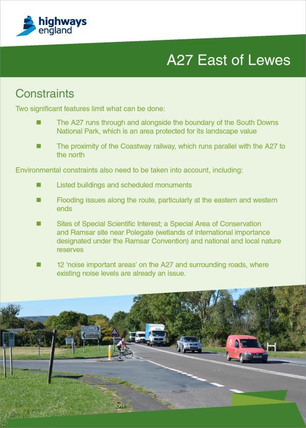

62 Appendix B: Consultation displays A27 East of Lewes Report on public consultation

63 A27 East of Lewes Report on public consultation


64 A27 East of Lewes Report on public consultation


65 A27 East of Lewes Report on public consultation

66 A27 East of Lewes Report on public consultation


67 A27 East of Lewes Report on public consultation


68 A27 East of Lewes Report on public consultation

69 A27 East of Lewes Report on public consultation

70 A27 East of Lewes Report on public consultation

71 A27 East of Lewes Report on public consultation

72 A27 East of Lewes Report on public consultation
73 A27 East of Lewes Report on public consultation

74 Appendix C: Consultation questionnaire A27 East of Lewes Report on public consultation
75

76
A27 East of Lewes improvement scheme Have your say
 A27 East of Lewes improvement scheme Have your say 27 October - 8 December 2016 2 About us Highways England is the government company charged with operating, maintaining and improving England s motorways
March Maidstone Integrated Transport Strategy Boxley Parish Council Briefing Note. Context. Author: Parish Clerk 2 March 2016
 Context. Author: Parish Clerk 2 The Draft Integrated Transport Policy (DITS) sets out a vision and objectives, and identifies a detailed programme of interventions to support the Maidstone Borough Local
Cycle traffic and the Strategic Road Network. Sandra Brown, Team Leader, Safer Roads- Design
 Cycle traffic and the Strategic Road Network Sandra Brown, Team Leader, Safer Roads- Design Highways England A Government owned Strategic Highways Company Department for Transport Road Investment Strategy
Update June 2018 OUR 2017 PUBLIC ENGAGEMENT
 Update June 2018 Hi, Let s Get Wellington Moving (LGWM) is developing a Recommended Programme of Investment (RPI) that meets our programme objectives and supports the city s and region s growth. As part
A1307 Haverhill to Cambridge: Approval to consult on transport improvement concepts
 Report To: Greater Cambridge City Deal Executive Board 3 March 2016 Lead Officer: Graham Hughes, Executive Director of Economy, Transport and Environment, Cambridgeshire County Council A1307 Haverhill
CAIRNGORMS NATIONAL PARK AUTHORITY FOR DECISION
 CAIRNGORMS NATIONAL PARK AUTHORITY FOR DECISION Title: Prepared by: A9 Dualling Project: Dalraddy to Slochd Murray Ferguson, Director of Planning and Rural Development and Gavin Miles, Head of Planning
Douglas Land Use and Transportation Strategy (DLUTS) Summary. August 2013
 Summary. August 2013") Douglas Land Use and Transportation Strategy (DLUTS) Summary August 2013 Background Douglas is a large and popular residential suburb of approximately 30,000 persons on the periphery of Cork City along
Douglas Land Use and Transportation Strategy (DLUTS) Summary August 2013 Background Douglas is a large and popular residential suburb of approximately 30,000 persons on the periphery of Cork City along
SH3 Waitara to Bell Block
 SH3 Waitara to Bell Block NZ Transport Agency August 2017 Community feedback report Copyright information This publication is copyright NZ Transport Agency. Material in it may be reproduced for personal
A19. Downhill Lane Junction Improvements Consultation Report April 2017
 A19 Downhill Lane Junction Improvements Consultation Report April 2017 CONTENTS 1 Introduction... 4 1.1 Purpose of the report... 4 1.2 Structure of the report... 4 1.3 Existing situation... 4 1.4 Scheme
Comments on the Hailsham to Eastbourne Sustainable Transport Corridor
 Comments on the Hailsham to Eastbourne Sustainable Transport Corridor Version 1.1 25/01/2015 Paul Humphreys 1 Table of Contents Version Control... 2 Summary... 2 Rationale provided by ESCC... 3 The ESCC
A30 Chiverton to Carland Cross Moving forward: The application
 A30 Chiverton to Carland Cross Moving forward: The application Foreword We are pleased to share the final plans for the A30 Chiverton to Carland Cross scheme with you following the submission of our application
Transport Workshop Dearbhla Lawson Head of Transport & Infrastructure Policy & Funding University of the Third Age.
 Transport Workshop Dearbhla Lawson Head of Transport & Infrastructure Policy & Funding University of the Third Age 30 th March 2015 1 Presentation Overview Roles and responsibilities Snapshot of Key Challenges
ANNEX1 The investment required to achieve the Government s ambition to double cycling activity by 2025
 ANNEX1 The investment required to achieve the Government s ambition to double cycling activity by 2025 May 2016 About Sustrans Sustrans makes smarter travel choices possible, desirable and inevitable.
A127/A130 Fairglen Interchange Improvement Schemes. Information Leaflet February 2017
 A127/A130 Fairglen Interchange Improvement Schemes Information Leaflet February 2017 1 2 Foreword By Councillor Kevin Bentley Essex is continuing to grow as a vibrant economic hub and as a fantastic place
London Cycle Network Annual Report 2000
 London Cycle Network Annual Report 2000 A cycle network for London by 2005 A cycle network for London by 2005 The London Cycle Network will: provide local links between residential neighbourhoods, railway
Improving the A1 in Northumberland Public consultation. November December North of Ellingham
 A1 Improving the A1 in Northumberland Public consultation November December 2016 North of Ellingham Improving the A1 in Northumberland In autumn 2014, the government announced the first Road Investment
Nottingham Cycle City Frequently Asked Questions
 Nottingham Cycle City Frequently Asked Questions About the scheme How much money is to be spent on cycling? And where is the money from? We have 6.1 million in Growth Fund which we will be investing directly
FAQ s Walsh Road / Ferguson Road Pilot Scheme
 FAQ s Walsh Road / Ferguson Road Pilot Scheme What is happening? Traffic calming measures are being installed as a pilot. Temporary Bollards will be installed to the east of 1 Ferguson Road and a Temporary
Technical note. 1. Introduction
 Project: A428 study - Phase 2 To: Adrian Shepherd Subject: Park & Ride site locations From: Atkins Date: Jun 3, 2016 cc: Ashley Heller 1. Introduction 1.1. Purpose of Technical Note The purpose of this
Easton Safer Streets - Final Project Report BRISTOL
 - Final Project Report BRISTOL A Sustrans Community Street Design Project in partnership with Bristol City Council February 07 About Sustrans Sustrans makes smarter travel choices possible, desirable and
MARKHOUSE ROAD IMPROVEMENTS
 MARKHOUSE ROAD IMPROVEMENTS www.enjoywalthamforest.co.uk Waltham Forest is changing and we want you to be part of it. Thanks to a funding pot of 27million from Transport for London, we re delivering the
CAMBOURNE TO CAMBRIDGE BETTER PUBLIC TRANSPORT PROJECT PHASE 2 PUBLIC CONSULTATION MADINGLEY MULCH ROUNDABOUT TO CAMBOURNE
 CAMBOURNE TO CAMBRIDGE BETTER PUBLIC TRANSPORT PROJECT PHASE 2 PUBLIC CONSULTATION MADINGLEY MULCH ROUNDABOUT TO CAMBOURNE Have your say on proposals for a new public transport link and Park & Ride facility
Active Travel Strategy Dumfries and Galloway
 Active Travel Strategy Dumfries and Galloway Our Active Travel Strategy The agreed Interventions for Dumfries and Galloway Council s Local Transport Strategy includes an action to Develop an Active Travel
Launceston's Transport Futures. Greater travel options for the people of Launceston
 Launceston's Transport Futures Greater travel options for the people of Launceston Final Draft 13 Jan 2014 1 Page Number Executive summary 3 What is Transport Futures? 4 Vision 6 Economy, access and liveability
September 2017 I City of New Westminster
 September 2017 I City of New Westminster Page 1 1. Context Sapperton is a predominantly residential community and home to the Royal Columbian Hospital (RCH). The neighbourhood is undergrowing major growth
Strategic Director for Environment. Enclosures Appendix A - Option drawings. Jamie Blake- Strategic Director for Environment
 Chipping Barnet Area Committee 9 July 2018 Title Report of Wards Status Urgent Key Cromer Road Request for 20mph Zone Strategic Director for Environment High Barnet Public No No Enclosures Appendix A -
LEA BRIDGE ROAD - A STREET FOR EVERYONE Public consultation document
 LEA BRIDGE ROAD - A STREET FOR EVERYONE Public consultation document TELL US Bakers Arms to Leyton Green Road (Section D, E, F) Leyton Green Road to Whipps Cross Roundabout (Section G) YOUR VIEWS www.enjoywalthamforest.co.uk
APPENDIX 2 PROPOSAL FOR REPLACEMENT FOR POOLE (DOLPHIN) LEISURE CENTRE FINAL SPECIFICATION
 LEISURE CENTRE FINAL SPECIFICATION") APPENDIX 2 PROPOSAL FOR REPLACEMENT FOR POOLE (DOLPHIN) LEISURE CENTRE FINAL SPECIFICATION 1 PURPOSE 1.1 To provide the following information and supporting evidence for the Member decision (reference
APPENDIX 2 PROPOSAL FOR REPLACEMENT FOR POOLE (DOLPHIN) LEISURE CENTRE FINAL SPECIFICATION 1 PURPOSE 1.1 To provide the following information and supporting evidence for the Member decision (reference
Community engagement guide May 2018
 Community engagement guide May 2018 Greater Wellington Regional Council (GWRC), Hutt City Council (HCC) and the New Zealand Transport Agency (NZTA) are working together to achieve some big improvements
MILTON ROAD LLF PROJECT UPDATE
 Greater Cambridge City Deal MILTON ROAD LLF PROJECT UPDATE 9 th May 2017 Project objectives Comprehensive priority for buses in both directions wherever practicable; Additional capacity for sustainable
Rural Economy and Connectivity Committee. Restricted Roads (20mph Speed Limit) (Scotland) Bill: Key Themes Arising from the Online Survey
 (Scotland) Bill: Key Themes Arising from the Online Survey") Rural Economy and Connectivity Committee Restricted Roads (20mph Speed Limit) (Scotland) Bill: Key Themes Arising from the Online Survey Introduction On Friday 9 November 2018, the Rural Economy and Connectivity
Rural Economy and Connectivity Committee Restricted Roads (20mph Speed Limit) (Scotland) Bill: Key Themes Arising from the Online Survey Introduction On Friday 9 November 2018, the Rural Economy and Connectivity
M6 Junction 10 Public Consultation
 M6 Junction 10 Public Consultation December 2015 Introduction Walsall Council and Highways England are developing plans to provide a long term improvement to M6 junction 10. We are holding this non-statutory
ENFIELD TOWN THE REVISED DESIGN
 TOWN THE REVISED DESIGN We re turning Enfield into a borough that encourages walking and cycling, a place that s easy for all of us to get around however we choose to travel. A greener place, with safer
Sustainable Urban Mobility Plan for Aberdeen, Scotland. Louise Napier Senior Planner Aberdeen City Council
 Sustainable Urban Mobility Plan for Aberdeen, Scotland Louise Napier Senior Planner Aberdeen City Council A bit about me.. Louise Napier Senior Planner (Transport Strategy & Programmes) Aberdeen City Council
Speed Limit Policy Isle of Wight Council
 APPENDIX B Speed Limit Policy Isle of Wight Council 2009 Contents Section 1 Introduction 1.1 Links with the Local Transport Plan Section 2 Speed Limits on Urban Roads and Residential Areas 2.1 20mph Limits
University of Victoria Campus Cycling Plan Terms of Reference. 1.0 Project Description
 University of Victoria Campus Cycling Plan Terms of Reference 1.0 Project Description The Campus Cycling Plan, a first for the University, will provide a comprehensive and coordinated approach to support
Public Consultation on Braintree Integrated Transport Package (ITP) HAVE YOUR. Consultation open from 24 September to 5 November 2018 SAY
 HAVE YOUR. Consultation open from 24 September to 5 November 2018 SAY") Public Consultation on Braintree Integrated Transport Package (ITP) HAVE YOUR SAY Consultation open from 24 September to 5 November 2018 Contents Introduction 3 Background 4 Springwood Drive Roundabout
Public Consultation on Braintree Integrated Transport Package (ITP) HAVE YOUR SAY Consultation open from 24 September to 5 November 2018 Contents Introduction 3 Background 4 Springwood Drive Roundabout
Appendix N(b): Portishead Station Outline Travel Plan
: Portishead Station Outline Travel Plan") Portishead Branch Lane (MetroWest Phase 1): Environment Impact Assessment Appendix N(b): Portishead Station Outline Travel Plan Prepared for West of England Councils September 2017 1 The Square Temple
Portishead Branch Lane (MetroWest Phase 1): Environment Impact Assessment Appendix N(b): Portishead Station Outline Travel Plan Prepared for West of England Councils September 2017 1 The Square Temple
Living Streets response to the Draft London Plan
 Living Streets response to the Draft London Plan Contents Living Streets response to the Draft London Plan... 1 About Living Streets... 2 Summary... 2 Consultation response... 3 Chapter 1: Planning London
Map 1 shows the two roads, and how they fit into the public transport network in and around Cambridge.
 Milton Road and Histon Road corridors bus priority infrastructure 1. Purpose The County Council would like to understand in more detail, the options to deliver the most effective corridor-based public
HAMILTON BIKING PLAN OUR VISION: A BIKE FRIENDLY CITY
 HAMILTON BIKING PLAN 2015-2045 OUR VISION: A BIKE FRIENDLY CITY INTRODUCTION Biking as a travel option is experiencing a resurgence internationally and in New Zealand, growing as a familyfriendly and healthy
Public Consultation Report December M6 Junction 10 Improvements
 Public Consultation Report December 2015 M6 Junction 10 Improvements Contents Section Title Page/s 1 Introduction 3-5 1.1 Main Objectives 3 1.2 Scheme Options 4 1.3 Project Timescale 5 2 Consultation exercise
Exhibit 1 PLANNING COMMISSION AGENDA ITEM
 Exhibit 1 PLANNING COMMISSION AGENDA ITEM Project Name: Grand Junction Circulation Plan Grand Junction Complete Streets Policy Applicant: City of Grand Junction Representative: David Thornton Address:
September HAWKHURST PARISH COUNCIL Page 1 of 13 SPORTS STRATEGY FINAL
 September 2017 HAWKHURST PARISH COUNCIL Page 1 of 13 SPORTS STRATEGY FINAL Table of Contents EXECUTIVE SUMMARY 3 1. INTRODUCTION 4 2. LOCAL CONTEXT 5 3. OBJECTIVES 7 4. PRIORITIES 8 5. FUNDING OPTIONS
Cabinet Member for Highways & Streetscene. Highway Infrastructure Manager
 LONDON BOROUGH OF RICHMOND UPON THAMES DATE: AUGUST 2015 DECISION MAKER: LEAD OFFICER: SUBJECT: WARDS: Cabinet Member for Highways & Streetscene Highway Infrastructure Manager PROPOSED CYCLING IMPROVEMENTS
Bramshaw traffic calming proposal
 - 1 - Bramshaw traffic calming proposal Initial options appraisal report July 2017 - 2-1. Project background Hampshire Country Council has commissioned Test Valley Borough Council to carry out an option
Bristol City Council has produced a draft Bristol Transport Strategy document.
 Bristol Transport Strategy Summary Document Introduction Bristol City Council has produced a draft Bristol Transport Strategy document. The Strategy fills a gap in transport policy for Bristol. We have
IAN WHITE ASSOCIATES. Crawley Station Gateway Public Realm
 IAN WHITE ASSOCIATES Crawley Station Gateway Public Realm contents 1. objectives & client brief 2. site appraisal 3. best practice guidance 4. design concept 1. objectives & client brief Crawley Train
M25 junction 28 improvement scheme. Have your say
 M25 junction 28 improvement scheme Have your say 14 November 2016 6 January 2017 M25 junction 28 improvement scheme Have your say About us IMAGE Highways England is the government company charged with
2. Context. Existing framework. The context. The challenge. Transport Strategy
 Transport Strategy Providing quality connections Contents 1. Introduction 2. Context 3. Long-term direction 4. Three-year priorities 5. Strategy tree Wellington City Council July 2006 1. Introduction Wellington
E4 Cycle Route Exeter University to Redhayes Bridge. - Recommendations from Exeter Cycling Campaign
 E4 Cycle Route Exeter University to Redhayes Bridge - Recommendations from Exeter Cycling Campaign 1.0 Introduction Exeter Cycling Campaign has prepared this report to provide recommendations for Devon
CAMBRIDGE SOUTH WEST PARK & RIDE
 CAMBRIDGE SOUTH WEST PARK & RIDE Have your say on: Extra Park & Ride spaces to the south west of Cambridge Bus priority measures into the city centre CREATING MORE PARK & RIDE SPACES The existing Park
Local Government Road Safety Summit - 9 April 2018
 Local Government Road Safety Summit - 9 April 2018 Report on outcomes The Associate Minister of Transport, Hon Julie Anne Genter held the Local Government Road Safety Summit in Wellington on 9 April 2018.
Final Plan 20 December 2016
 Final Plan 20 December 2016 Introduction Aims of the Travel Plan How do we travel? Understanding travel behaviours? The University Master Plan and its implications Galway City sustainable transport policies
Birmingham Connected. Edmund Salt. Transportation Policy Birmingham City Council
 Birmingham Connected Edmund Salt Transportation Policy Birmingham City Council www.birmingham.gov.uk/connected Birmingham Connected the story so far Broadly following EU Guidance We ve done all of this
Cycle network linking Wolverhampton city centre and Bilston town centre with employment sites and residential areas:
 Context and Problems Corridor length 12.3 km; Population within 800m 59,922; Jobs within 800m 59,100; Unemployment 11%; Average Index of Multiple Deprivation 46; Households with no car 45%; Proportion
PEDESTRIAN ACTION PLAN
 ATTACHMENT 2 CITY OF SANTA MONICA PEDESTRIAN ACTION PLAN CITY OF SANTA MONICA PEDESTRIAN ACTION PLAN This page intentionally left blank EXECUTIVE SUMMARY CHAPTER 1 EXECUTIVE SUMMARY Setting the Stage
Greater Cambridge Partnership Cambourne to Cambridge Better Bus Journeys: Phase One Summary Report of Consultation Findings
 Produced by the Cambridgeshire Research Group Greater Cambridge Partnership Cambourne to Cambridge Better Bus Journeys: Phase One Summary Report of Consultation Findings Version 2 Feb 2018 Cambridgeshire
Cycling and Walking Investment Strategy & Local Cycling and Walking Infrastructure Plans
 Cycling and Walking Investment Strategy & Local Cycling and Walking Infrastructure Plans 1 Investing in cycling and walking contributes to a broad range of cross-cutting policy objectives Cycling and walking
9. Parking Supporting Statement
 9. Parking Supporting Statement Content 1. Setting the Scene 2. Vision 3. Parking and the Shared Priorities 4. Issues 5. Delivery Programme in the first Plan Period 2001/02 2005/06 6. Good Practice 7.
Safe Speed programme ATTACHMENT 1. Randhir Karma, Group Manager Network Management and Safety
 Safe Speed programme ATTACHMENT 1 Randhir Karma, Group Manager Network Management and Safety 1 Why Safe Speeds? AT s strategic context National guidance AT has embraced Vision Zero principles and recognises
Cycle Routes. Traffic Advisory Leaflet 3/95 March Introduction. Implementation. Project aims. Design
 Traffic Advisory Leaflet 3/95 March 1995 Cycle Routes Introduction The leaflet summarises the findings of the Cycle Routes Programme. This research was undertaken for the Department of Transport by the
Guildford Borough (Draft)
") ITEM Annex Page 7 Guildford Borough (Draft) Forward Programme Part A This is a work in progress and its completion is subject to the adoption of the Local Plan and Infrastructure Delivery Schedule November
ITEM Annex Page 7 Guildford Borough (Draft) Forward Programme Part A This is a work in progress and its completion is subject to the adoption of the Local Plan and Infrastructure Delivery Schedule November
WEST YORKSHIRE LTP CYCLE PROSPECTUS
 WEST YORKSHIRE LTP CYCLE PROSPECTUS The West Yorkshire Ambition: To be recognised as a great place for safe cycling, inspiring more people to cycle more often. INTRODUCTION Cycling is low cost, environmentally
GD 0043/18 ACTIVE TRAVEL STRATEGY
 GD 0043/18 ACTIVE TRAVEL STRATEGY 2018-2021 May 2018 Minister s Introduction There is strong evidence that regular physical activity reduces the risk of a range of health conditions. The best way to increase
Part 3: Active travel and public transport planning in new housing developments
 1 Linking active travel and public transport to housing growth and planning Part 3: Active travel and public transport planning in new housing developments Active Travel Toolkit Slide Pack July 2017 Linking
IMPACT OF THE BERMUDA CONNECTIVITY PROJECT ON CYCLING
 IMPACT OF THE BERMUDA CONNECTIVITY PROJECT ON CYCLING BBAG BRIEFING NOTE EMAIL: BERMUDABRIDGEAGP@BTINTERNET.COM WWW.FACEBOOK.COM/GROUPS/BERMUDABRIDGEAG TWITTER @BERMUDABRIDGEAG CYCLING BBAG BRIEFING NOTE
1.5 On this basis it is fundamental that the Transport Strategy for the site focuses on the following key criteria,
 1.0 Introduction 1.1 The Transport Assessment has been prepared on behalf of Eon and Roger Bullivant Ltd in respect of the proposed mixed use sustainable urban extension of Drakelow Park. 1.2 The methodology
Section 2 Strategic Alignment. Contents
 Section 2 Strategic Alignment Contents 2 Strategic Alignment... 2 2.1 General... 2 2.2 SmartGrowth Strategy and Implementation Plan... 2 2.3 Walking and Cycling Strategy... 3 2.4 Built Environment Strategy...
A27 Worthing and Lancing: facilities for walking, cycling, and horse riding [nonmotorised
 A27 Worthing and Lancing: facilities for walking, cycling, and horse riding [nonmotorised users (NMUs)] Introduction This note describes our understanding of the needs of Non-Motorised Users (NMUs) as
SCATE. South Coast Alliance on Transport and the Environment. Issues to be addressed by the A27 Corridor Feasibility Study
 SCATE South Coast Alliance on Transport and the Environment Issues to be addressed by the A27 Corridor Feasibility Study Submitted to the Department of Transport July 2014 Contents: 1. The evidence so
Active Travel Towns Funding Scheme Project Proposal. Sligo. Sligo Local Authorities
 Active Travel Towns Funding Scheme 2014-2016 Project Proposal for Sligo by Sligo Local Authorities Introduction Over the last two years, Sligo Local Authorities have implemented years 1 & 2 of their 5
Wellington Public Transport Spine Study
 Wellington Public Transport Spine Study Study purpose Feasibility study Options for a high quality, high frequency PT system Key action from Ngauranga to Airport Corridor Plan (2008) Long-term outlook
Warfield Neighbourhood Plan: 4.4 Infrastructure
 Warfield Neighbourhood Plan: 4.4 Infrastructure Previously decided Policy headings: Policy WNP16 Transport Impact of Development Policy WNP17 Transport Proposals Policy WNP18 New School Buildings Policy
Design Workshops Summary of all Feedback January 2017
 Histon Road Corridor Design Workshops Summary of all Feedback January 2017 CITY DEAL AND GROWTH Commitment to Growth: Government, County, City and District Emerging Local Plans: 33,000 new homes 45,000
A future cycle route network for North Staffordshire mb/08/16 Need for a strategy. Existing cycle route network
 Need for a strategy 1. The government s aim is to double cycling levels nationally by 2025 [note 1]. This would bring significant health, environmental, economic and traffic benefits [note 2]. It is widely
LET US KNOW WHAT YOU THINK
 A164 and Jock s Lodge Junction Improvement Scheme Funding Bid PUBLIC CONSULTATION November 2017 Public Exhibition to be held at Beverley Racecourse on Wednesday 8 th November 2017 between 9.30 am and 6.45
Regional Bus Priority
 Regional Bus Priority Recommendation(s) That the Board: i) Notes the systematic review for bus priority measures on the proposed Frequent Transit Network (FTN). Executive summary The New Network public
Background. Caversham a vision for the future. Joint public meeting arranged by:
 Joint public meeting arranged by: Sharing our Streets Caversham a vision for the future and Caversham Traders Association This presentation followed a presentation by Simon Beasley, Network Manager for
Rochester Area Bike Sharing Program Study
 roc bike share Rochester Area Bike Sharing Program Study Executive Summary ~ January 2015 JANUARY 2015 8484 Georgia Avenue, Suite 800 Silver Spring, MD 20910 3495 Winton Pl., Bldg E, Suite 110 Rochester,
Walking and Cycling Action Plan Summary. A Catalyst for Change The Regional Transport Strategy for the west of Scotland
 Walking and Cycling Action Plan Summary A Catalyst for Change The Regional Transport Strategy for the west of Scotland 2007-2021 Strathclyde Partnership for Transport Contents Purpose...2 Issues, Constraints
Regional Cycle Programme Update
 Agenda Item 10 (ii) Regional Cycle Programme Update Glossary Auckland Council Auckland Transport Cycle Action Auckland New Zealand Transport Agency Regional Cycle Network (AC) (AT) (CAA) (NZTA) (RCN) Executive
Strategy for Walking & Cycling Action Plan
 Strategy for Walking & Cycling Action Plan To achieve higher levels of walking and cycling activity, the destinations which people access have to be available within suitable distances and designed to
Appendix 12 Parking on footways and verges
 Appendix 12 Parking on footways and verges Legal position Parking on footways and verges whether wholly or partly is banned throughout London, unless signs are placed to allow parking. The ban requires
University of Leeds Travel Plan
 University of Leeds Travel Plan 2015-2018 Contents 1: Introduction 1.1 What is a Travel Plan? 1.2 Why do we need one? 1.3 Sustainability Strategy 2: Overview 2.1 The bigger picture 2.2 The City scale 2.3
Roads and public rights of way
 Roads and public rights of way This factsheet outlines how the effects of the Proposed Scheme on roads and public rights of way (PRoW) along the line of route would be managed. Version 1.0 Last updated:
Ormond & McKinnon Walks Response to Draft Glen Eira Community Plan
 Response to Draft Glen Eira Community Plan We would like to take this opportunity to thank Glen Eira City Council for the opportunity to comment on the Glen Eira Draft Community Plan. Below is an outline
KEY FINDINGS OF THE INTERIM EVALUATION OF THE SMARTER TRAVEL AREAS PROGRAMME
 Proceedings 1st - 2nd September 2016 BRICK, CANTWELL, SWIFT: Smarter Travel Areas KEY FINDINGS OF THE INTERIM EVALUATION OF THE SMARTER TRAVEL AREAS PROGRAMME Elaine Brick Associate Director AECOM Mairead
Road Safety in Radyr and Morganstown: the Community Council's response to Cardiff Council's draft scheme layout for highway improvements
 Road Safety in Radyr and Morganstown: the Community Council's response to Cardiff Council's draft scheme layout for highway improvements Introduction Radyr and Morganstown Community Council has been invited
TABLE OF CONTENTS 1 EXECUTIVE SUMMARY INTRODUCTION THE CONSULTATION APPROACH CONSULTATION EFFECTIVENESS... 17
 TABLE OF CONTENTS 1 EXECUTIVE SUMMARY... 1 1.1 CONTEXT... 1 1.2 SCHEME BACKGROUND... 1 1.3 THIS REPORT... 2 1.4 THE PROPOSAL... 3 1.5 CONSULTATION ARRANGEMENTS... 3 1.6 EFFECTIVENESS OF THE PUBLIC CONSULTATION...
Local Highway Panels Members Guide. 2 Speed and Traffic Management
 Local Highway Panels Members Guide 2 Speed and Traffic Management 2 Local Highway Panels (LHP) Members Guide 2016/17 1. Introduction Following the publication of the DfT guidance on setting local speed
Service Business Plan
 Service Business Plan Service Name Transportation Planning Service Type Public Service Owner Name Kaylan Edgcumbe Budget Year 2019 Service Owner Title Service Description Manager of Transportation Planning
Douglas Land Use and Transportation Study
 Douglas Land Use and Transportation Study Summary: Key: Yellow Box = key project information Green Box = project recommendations Grey Box = anticipated project outcomes Background: It is an objective of
Sherwood Drive Traffic Circle
 Strathcona County Sherwood Drive Traffic Circle Online Survey Results April 7, 215 I. Executive Summary The Sherwood Drive Traffic Circle Survey was administered in March 215. In total, 2,263 residents
Our Approach to Managing Level Crossing Safety Our Policy
 Our Approach to Managing Level Crossing Safety Our Policy Our policy towards managing level crossing risk is: that we are committed to reducing the risk at level crossings where reasonably practicable
Hamilton Transportation Master Plan Public Consultation. Public Information Centre One Summary
 Hamilton Transportation Master Plan Public Consultation Public Information Centre One Summary Table of Contents Introduction 1 Purpose 2 What Was Presented 2 Who Came to the Meeting 2 The Breakout Sessions
Highways England Road Safety Ambition. David Stones PACTS Autumn 2015 Conference 3 nd November 2015
 Highways England Road Safety Ambition David Stones PACTS Autumn 2015 Conference 3 nd November 2015 Highways England Strategic Road Network 4,300 miles (40% Motorway & 60% All Purpose Trunk Road). 34% of
City of Hamilton s Transportation Master Plan (TMP) Public Consultation 3 December 2015
 Public Consultation 3 December 2015") City of Hamilton s Transportation Master Plan (TMP) Public Consultation 3 December 2015 McPhail Transportation Planning Services Ltd. AGENDA 6:00 7:00 pm Viewing Boards / Q & A with the Team 7:00 7:50
City of Hamilton s Transportation Master Plan (TMP) Public Consultation 3 December 2015 McPhail Transportation Planning Services Ltd. AGENDA 6:00 7:00 pm Viewing Boards / Q & A with the Team 7:00 7:50
The Cabinet Member for Highways & Streetscene. Aurang Zeb - Head of Highways & Transport
 LONDON BOROUGH OF RICHMOND UPON THAMES Cabinet Member Decision DATE: January 2012 REPORT OF: LEAD OFFICER: SUBJECT: WARDS: The Cabinet Member for Highways & Streetscene Aurang Zeb - Head of Highways &
Current Travel Needs and Operating Conditions (See pages 4 9 of the Discussion Guide)
") Phase 1 Consultation: Understanding the Need Feedback Form Thank you for participating in this phase of planning for the George Massey Tunnel Replacement. Your feedback is important to us. Input received
Phase 1 Consultation: Understanding the Need Feedback Form Thank you for participating in this phase of planning for the George Massey Tunnel Replacement. Your feedback is important to us. Input received