Public Consultation Report December M6 Junction 10 Improvements
|
|
|
- Theresa Greene
- 5 years ago
- Views:
Transcription

1 Public Consultation Report December 2015 M6 Junction 10 Improvements
2 Contents Section Title Page/s 1 Introduction Main Objectives Scheme Options Project Timescale 5 2 Consultation exercise Overview Promoting the consultation Questionnaires 9 3 Questionnaire results and analysis Travel behaviour Proposed improvement Conclusion Further information - contact details Appendices 21 2
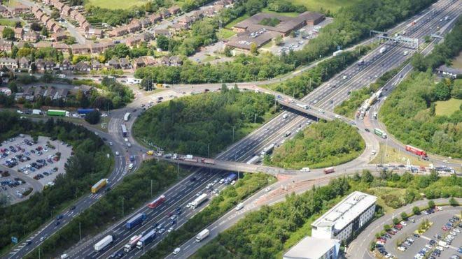
3 1.0 Introduction Walsall Council is working in partnership with Highways England to improve Junction 10 of the M6 motorway (M6J10). As a busy route between Walsall and Wolverhampton, the junction is often heavily congested and this reduces the attractiveness of the local area for business and investment, including within the nearby Black Country Enterprise Zone. Walsall Council and Highways England are developing plans to provide a long term improvement to M6 Junction 10. The non-statutory public consultation events held in December 2015 presented the current scheme options and sought comments and feedback to inform the final decision and help shape the design. 1.1 Main objectives of the scheme There are three main objectives of the M6J10 scheme. The first objective is to reduce congestion. By improving M6J10, congestion can be reduced on the A454 Black Country Route eastbound to improve journey time reliability. This is critical to the needs of local residents, businesses and the 120 hectares of developable land within the nearby Black Country Enterprise Zone. Congestion can be reduced on other roads linking to the junction, such as A454 Wolverhampton Road, B4464 Wolverhampton Road West and Bloxwich Lane, reducing rat-running traffic on nearby routes parallel to the A454 Black Country Route, the A454 Wolverhampton Road and the B4464 Wolverhampton Road West. The second objective is to support economic growth with the enhancement of transport infrastructure. Improving M6J10 will complement recent investments in local transport infrastructure made by Walsall Council which includes the 26m Darlaston Strategic Development Area (DSDA) Access Project. Highways England has also made significant recent investment with Smart Motorways at M6 Junctions 5-8 and 10A-13. Together these schemes will result in enhanced operational conditions for existing businesses, especially those with Heavy Good Vehicles (HGVs) that rely on excellent links to the strategic road network. New business and development will be attracted to the area by enhanced road infrastructure and reduced journey times. The third objective is to provide a safe and serviceable network. Replacing the bridge structures over the M6 motorway and avoiding major maintenance work on the structures in the near future. Conditions for cyclists, pedestrians and other nonmotorised users can also be enhanced. In addition to addressing all of the above the option selected will also provide good value for money. 3
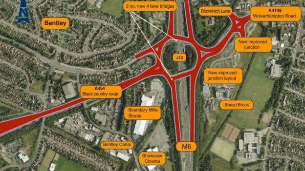
4 1.2 Scheme Options Previous Options Considered In June 2013, Walsall Council in conjunction with Highways England went through a detailed process of assessing a number of design options for M6J10. The assessments were based on traffic modelling, design and maintenance considerations. These five options, together with the outcomes of the option assessment and plans were included in the material produced for the consultation. Below are the main reasons why four of the five the previous options were discounted Option 2; four new straight bridges including two lanes on each bridge Creating four new additional structures will require a bigger maintenance programme in the future causing more disruption. Option 3; retain the existing bridges, build two new bridges two lanes on each bridge Continued use of the existing bridges would require an extensive and ongoing maintenance programme causing more disruption. Furthermore there would be insufficient width between the bridges to install a vehicle restraint system to be compliant with current standards. Option 4; two new straight bridges, including two lanes plus a flyover Option discounted as it cannot be constructed within the footprint of the junction, particularly on the A454 Wolverhampton Road side. The existing structures would also need replacing. Option 5; two new straight two lane bridges plus a centre straight through bridge The addition of the centre bridge introduces an additional traffic signal stage on each side of the roundabout which cause traffic build up. The existing structures would also need replacing. The preferred options The reasons why option 1a and 1b are the preferred options. Option 1a; two new straight bridges including four lanes on each bridge This option offers the largest improvement when reducing congestion. Both existing structures will be replaced reducing future maintenance costs. New bridge structures can be constructed alongside the existing reducing disruption during construction. Options 1b; two new curved bridges including four lanes on each bridge Also offers the largest improvement when reducing congestion. Both existing structures will be replaced reducing future maintenance costs. New bridge structures can be partially constructed alongside the existing reducing disruption during construction. The consultation materials included full scheme options can be found in Appendix 6.1 and
5 1.3 Project timescale The December 2015 consultation was the opportunity for stakeholders to give their views on the options proposed ahead of further development of the scheme and the selection of a preferred design. Following the closure of the consultation period on Sunday 24 January 2016, Walsall Council and Highways England have considered all of the responses and opinions of the public, local groups and organisations. This has enabled further development of the scheme. The preferred design will be announced around September Once the design has been announced a second public consultation will be conducted. This consultation will be part of the process of taking the preferred scheme option towards gaining funding, planning approval and any required statutory powers that are needed in order for the scheme to be built. At present Walsall Council and Highways England anticipate that the scheme will take approximately two years to build, starting construction during 2018 and then being open to traffic during

6 2.0 December 2015 Consultation Exercise 2.1 Overview A non-statutory joint consultation exercise between Walsall Council and Highways England was open from Thursday 3 December, 2015 until Sunday 24 January The exercise saw Walsall Council and Highways England officers attend five events in total. The first event had a specific and distinct purpose, to announce the project to the relevant news media outlets and to then engage separately with local politicians and key organisational stakeholders (emergency services, bus companies, etc). The following four events were all fully open to all, including the general public. The details of the consultation events were as follows: 1. Friday 4 December 2015; 12pm - 4pm; Tesco, Owen Rd, Willenhall 2. Saturday 5 December 2015; 10am - 2pm; Holiday Inn, Wolverhampton Road West 3. Monday 7 December 2015; 2pm - 7pm; The Village Hotel, Tempus Drive, Walsall 4. Wednesday 9 December 2015; 10am - 4pm; The New Art Gallery, Gallery Square At all of the events, seven banners were erected which displayed information about the scheme, covering topics such as justification, objectives and the preferred options for the scheme. Attendees were invited to talk through the scheme and the options. Brochures containing similar information were available to take away, this also contained information on how to complete the questionnaire. This could be done by either filling-in a paper copy or going to the Walsall Council website where an electronic copy could be filled-in and then submitted. Holiday Inn Event 6

7 7 Walsall Art Gallery Event
8 2.2 Promoting the consultation Direct promotion to residents In advance of the first event, letters were hand delivered to households and business within an area of influence of M6 J10. In total around one thousand letters were delivered to the nearest residents to the junction. Direct promotion to businesses Officers of Walsall Council made contact via with over six thousand business contacts across the borough. M6 Junction 10 is the key link to the motorway network for businesses across much of the borough. The s were supplemented with faceto-face visits to twenty companies. These companies are located within a half-mile radius of the junction and were identified as either key employers or originators of significant volumes of road traffic. On-street promotion Around one hundred and fifty A4 posters were erected on lamp columns close to the consultation event - a week in advance of the first event. The posters listed the dates and locations of all events. News media promotion The press event which began the public consultation period was used to publicise the event and the wider project to local news media. This resulted in a front page story on the main local newspaper, the Express & Star, which covers all of the Black Country and large parts of the wider West Midlands region, and a piece on BBC Midlands Today 3 November, Online and social media promotion Finally, information about the consultation period and about the project more generally was made available on both the Walsall Council and Highways England websites. Alongside this, the social media channels of both Walsall Council and Highways England namely Facebook and Twitter were used, firstly, to inform the public about the consultation events and, secondly, to inform the public as to how they could respond to the consultation with their views of the proposals to improve M6 Junction Copies of consultation materials All consultation materials can be found on the M6 J10 website, and at the end of this report in Appendix 6.1 and Total attendance & questionnaires By the end of the final consultation event, a total of 265 people had attended. By the time the overall consultation period closed on Sunday 24 January 2016, a total of 217 questionnaire responses had been submitted. It is those 217 responses from which this report draws all data and subsequent analysis. 8
9 2.5 Questionnaires A questionnaire was designed in order to elicit feedback from stakeholders as part of the consultation. The questionnaire contained multiple choice, tick-box, and ranking of importance style questions. These asked respondents to detail their frequency of travel through M6 J10, their main mode/s of transport and their journey origins and destinations. Respondents were also asked to give their views on the potential effectiveness of each of the preferred options, if they disagreed or agreed with any part of the scheme, and to state in detail their reasons why. The questionnaire is key to the consultation as it was our main method of eliciting both quantitative and qualitative information giving a detailed and holistic overview of current public perceptions of the proposals to improve M6 Junction 10. As such, analysis of the results of the questionnaire will form the bulk of the remainder of this public consultation report. For reference, as with all other public consultation materials, the questionnaire can be found at in Appendix
10 3.0 Questionnaire results and analysis The questionnaire asked 15 questions of all respondents with those questions addressing two broad but distinctly different topics. The first topic related to respondent travel behaviour whilst the second topic related to respondent perceptions of the proposed improvement. The remainder of Section 3 is split into these 2 sections and deals in chronological order with each question, describing and then analysing the received responses. 3.1 Questions pertaining to respondent travel behaviour Questions 1 to 6 of the questionnaire related to how and when the consultees used M6 J10. Results can be see below Question Question 2 10


11 3.1.3 Question Question Question 5 11

12 3.1.6 Question 6; please tell us your home postcode. The full post codes provided were used to create the map above. Most of the people who responded to the questionnaire live in Walsall or Wolverhampton. However some were as far away as Gillingham, Corby, Wilmslow and Dorset, which couldn t be plotted on this map. 12
13 3.2 Questions pertaining to respondent perceptions of the proposed improvement Questions 7 to 15 relate to the scheme options for M6 J10 and ultimately which of the preferred options is most desirable Question 7 Out of the 217 people who responded to the consultation 92% either strongly agreed or agreed that M6 J10 needs improvement. Compared to only 8% of respondents who either strongly disagreed or disagreed that M6 J10 needs improvement. 13
14 3.2.2 Question 8 Consultees were asked the reasons why they agreed or disagreed that M6 J10 needs improvement. Out of the 217 people who answered question 7, 170 people gave a single or multiple reasons. From question 7 we can see that 200 people either strongly agreed or agreed that M6 J10 needs improvement. A total of 178 reasons were given by the 200 respondents. The reasons given fall into one of the categories below in Table 1. Out of the respondents who either strongly agreed or agreed 82.57% felt that congestion is the main issue at M6 J10. Table 1 Reason for strongly agree or agree Agree Percentage (%) Congestion/Capacity Current arrangement not adequate 3.97 Poor road surface 4.48 Road Safety issues 2.81 Current traffic signal timings/setup not working 1.69 Noise / Pollution issues 1.12 Age of structure 1.12 Lack of pedestrian / cycling facilities 0.56 Current arrangement gives a poor image for the region 0.56 Other people either strongly disagreed or disagreed that M6 J10 needs improvement. A total of 14 reasons were given by the 17 respondents. The reasons given, fall into one of the categories below in Table 2. Table 2 Reason for strongly disagree or disagree Disagree Percentage (%) Congestion problems are on the M6 motorway not the island Current scheme options not suitable Not value for money / Cost too high Current configuration is sufficient Increasing capacity not the answer 7.14 Concerns widening will cause road safety issues 7.14 Concerned with disruption/delay caused by works 7.14 The top reason, at 35.71% was that congestion problems on the M6 motorway were an issue rather than on the M6 J10 island. However, this was only 2.6% of the overall reasons given as shown in Table 3 on page
15 Table 3 Reason Fell into Agree or Disagree Overall % Congestion/Capacity Agree Current arrangement not adequate Agree 3.65 Poor road surface Agree 4.18 Road Safety issues Agree 2.6 Current traffic signal timings/setup not working Agree 1.56 Noise / Pollution issues Agree 1.04 Age of structure Agree 1.04 Lack of pedestrian / cycling facilities Agree 0.52 Current arrangement gives a poor image for the region Agree 0.52 Other Agree 1.04 Congestion problems are on the M6 motorway not the island Disagree 2.6 Current scheme options not suitable Disagree 1.04 Not value for money / Cost too high Disagree 1.04 Current configuration is sufficient Disagree 1.04 Increasing capacity not the answer Disagree 0.52 Concerns widening will cause road safety issues Disagree 0.52 Concerned with disruption/delay caused by works Disagree 0.52 Total 100 % Question 9 Please read all of the considerations below and rank (number) them in order of importance to you. An average score was calculated from the two hundred and seventeen responses and were ranked in order of importance as below: 1. The congestion is reduced 2. The safety of road users 3. Disruption to road users during construction 4. The ease of use / navigation 5. The time taken to complete the scheme 6. Pedestrian Safety 7. Cycle user safety 8. The cost 9. The environmental impact 10. The impact on surrounding land 11. The visual impact 15
16 3.2.4 Question 10; is there anything else you think is important when choosing a design option for M6 J10? Please see section Question Question 12 Why do you say option 1a is best? Out of the 41 people who chose 1a, 36 people gave a single or multiple reasons which fell into the categories below. Reasons why option 1a is best Percentage (%) Offers the best layout Least impact during construction Question 13 Why do you say option 1b is best? Out of the 52 people who chose 1b, 46 people gave a single or multiple reasons which fell into the categories below. Reasons why option 1b is best Percentage (%) Offers the best layout Aesthetically pleasing 8.68 Least impact during construction
17 3.2.8 Question 14 Why do you say either or neither option is suitable? Out of the 48 people who said either 1a or 1b is suitable, 37 people gave a single or multiple reasons which fell into the categories below. Reasons why either option 1a or 1b Percentage (%) The two designs are very similar Other Out of the 13 people who said neither 1a nor 1b is suitable, 13 people gave a single or multiple reasons which fell into the categories below. Reasons why neither option is suitable Percentage (%) Discounted options were better Neither of the preferred option designs are suitable Cost too high Motorway traffic is the issue rather than the island 7.69 After reading the consultation material and discussing the options with project staff at the consultation events, 65% of all respondents felt that 1a, 1b or either option is most suitable. 21% said that they didn t know and only 6% felt that neither was suitable. Layout of the new design was most important to respondents, with least impact caused during the new the construction also being an important factor. Of the 6% who felt that neither option was suitable, most respondents were concerned about the cost of the scheme and that the preferred options were not suitable. Section 2.1 of the report explains that Walsall Council and Highways England have been through a detailed process of selecting the most viable options to take forward, hence why options 1a and 1b were promoted during the consultation. 17
18 3.8.9 Questions 10 and 15; Is there anything else you think is important when choosing a design option for M6 J10? Do you have any other suggestions for how M6 J10 might be redesigned? Questions 10 and 15 gave the respondent the opportunity to inform Walsall Council and Highways England of what they feel is important for the design of M6 J10 and if they had a suggestions for the ongoing redesign. There were many different suggestions, with some common themes. Congestion reduction was ranked the most important in the responses to question 9 and the comments written for questions 10 and 15 confirmed this further. Respondents felt that the chosen design should offer the highest reduction in congestion and this should be future proofed for traffic growth in years ahead. Ease of navigation, including advanced warning signs, advising users of the lane discipline was also a common suggestion. Pedestrian and cyclist safety is important to respondents; it was felt that if possible, segregation would provide the safest route for these users. Some comments talked about the vehicles travelling across M6 J10 and not joining the motorway. A few respondents felt that segregating this traffic in the form of a fly over would ease congestion further. A Flyover was one of the options previously considered and was discounted in terms of the ability to actually build the structure. Constraints at this location mean that that type of structure isn t possible. When the work is due to commence at M6 J10 the comments suggested that it is important to have frequent progress updates and that the impact for local residents should be considered and prioritised. Another common theme was that M6 J10 should be aesthetically pleasing as it often the first impression people have of Walsall and the region. If not already explored, comments in the above sections will be considered when choosing the most viable option for M6 J10, and will be accommodated were possible. 18
19 4.0 Conclusion As we can see from the responses in section 3.1, the improvement at M6J10 will affect a lot of people travelling at all times of day and throughout the week across the loc al area. It is critical for all road users, both residents and businesses alike. Also, as a part of the motorway network the scheme will clearly affect travellers who live a long distance from the junction, some respondents to the survey lived as far a way as Gillingham, Corby, Wilmslow and Dorset. Walsall Council and Highways England are working in partnership to develop a viable design option to improve M6 J10. Congestion-reduction is the main aim of the scheme, which will in turn promote economic growth for the region. The results listed in this report have concluded that the vast majority of respondents agree that an improvement is needed for M6J10, with congestion being the primary concern for those who agreed. After thorough consideration of the options in 2013, options 1a and 1b were put forward for this public consultation in December The majority of respondents agreed that one of these options or either of them is the most suitable. Ongoing investigation into options 1a and 1b will determine which option is the most viable in terms of the ability to actually build the structures and total cost. Computer generated traffic modelling will help determine which design is the most efficient. The chosen option will be announced in autumn
20 5.0 For further information Steven Edwards Principal Transport Planner Walsall Council M6 J10 Project Manager Contact: Walsall Council Strategic Transportation Economy and Environment Zone 2K, Civic Centre Darwall Street WS1 1DG David Reed Highways England M6 J10 Project Manager Contact Highways England The Cube 199 Wharfside Street Birmingham B1 1RN Website: Project address: 20
21 6.0 Appendices 6.1 Consultation banners 6.2 Consultation brochure 6.3 Letter to residents 6.4 to businesses 6.5 Questionnaire 6.6 Press cutting 21
22 Appendix 6.1 Consultation Banners

23 Highways England Creative Xxxxxxx M6 Junction 10 Public Consultation Public Consultation: Options Walsall Council and Highways England are developing plans to provide a long term improvement to M6 junction 10. We are holding this non-statutory public consultation to present the current scheme options and seek comments and feedback to inform the final decision and help shape the design. M6 junction 10 is a congested location on both the national motorway network and on the local road network within Walsall.

24 Highways England Creative Xxxxxxx M6 Junction 10 Public Consultation Introduction M6 junction 10 currently experiences significant congestion and resultant delays particularly during morning and evening peak times. The area suffers from long queues at peak times on the A454/ Black Country Route west of M6 junction 10 and from M6 junction 10 to the junction with Bentley Road South. The junction is of strategic importance to Walsall and the wider area, providing access to the West Midlands. However, these queues affect the local community and business environment quite significantly, making it harder for businesses to get their goods and services to market, impacting local businesses and jobs. There is also significant queuing on the roundabout and both the on and off motorway slip roads. Congestion also occurs on other roads leading to the junction, such as A454/ Wolverhampton Road, B4464/Wolverhampton Road West and Bloxwich Lane.

25 Highways England Creative Xxxxxxx M6 Junction 10 Public Consultation Objectives The main objectives of the scheme are to: 1. Provide a more free flowing network by; 3. Provide a safe and serviceable network with improved - reducing congestion on the A454/Black Country Route access by; eastbound to improve journey time reliability, critical to the needs - replacing the structures that carry M6 junction 10 over the M6 of local residents, businesses and the Black Country Enterprise Zone; and avoiding major maintenance work on the structures in the near future; - reducing congestion on other roads linking to the junction, - improving conditions for cyclists, pedestrians and other nonmotorised - reducing rat-running traffic on nearby routes users at the junction. In addition to addressing all of the above the option selected will also provide good value for money. 2. Support economic growth by; - improving transport in the local area to tie-in with significant recent investments made by Walsall Council in local transport infrastructure with the 26m Darlaston Strategic Development Area (DSDA) Access Project and by Highways England with Smart Motorways at M6 junctions 5-8 and 10a-13; - enhancing operational conditions for existing businesses, that rely on excellent links to the strategic road network; - attracting new business and development to the area by enhanced road infrastructure. Supporting the commitment Central Government made to Walsall for numerous designated development sites and Enterprise Zone status in Gas holders site Parallel 9-10 Aspect 2000 Phoenix 10 Phoenix 10

26 Highways England Creative Xxxxxxx M6 Junction 10 Public Consultation Environment As the volume of traffic and congestion continues to rise it will have a greater impact upon the local environment. We have considered this in our options, with several issues requiring consideration within the design of the chosen option. Noise pollution and reduced air quality associated with high volumes of slow moving or stationary traffic impacts on local residents, especially those that live adjacent to roads leading to M6 junction 10 Unwelcoming and potentially dangerous environment for pedestrians and cyclists that use the junction and nearby roads The local natural environment provides habitats for protected species around the junction and adjacent roads. In addition to the above general environmental issues there are various specific environmental issues in close proximity to M6 junction 10. The main specific issues, listed below, are the presence of the following: an Air Quality Management Area in the local area a DEFRA Noise Improvement Area nearby an underground canal culvert habitats along nearby watercourses, both the Walsall Canal and the River Tame key community facilities, such as schools, local shops and hotels area of housing, including; adjacent the southbound off-slip, adjacent the A454 (Black Country Route and Wolverhampton Road), and, adjacent Wolverhampton Road West (B4464) The above will need to be taken into consideration by Walsall Council and Highways England both during the design and construction phases of the project.


27 Highways England Creative Xxxxxxx M6 Junction 10 Public Consultation Preferred options Option 1a, Two new straight four lane bridges Option 1b, Two new curved four land bridges Option 1a; Two new straight four lane bridges Option 1b; Two new curved four lane bridges Impact on journey: Long distance All options are likely to show a similar, slight degree of improvement for long distance (motorway) traffic Local Large improvement; this option is expected to show significant reductions to queues and delays on the A454/Black Country Route and slip roads. Largest improvement; this option is expected to show significant reductions to queues and delays on the A454/Black Country Route and slip roads. Efficiency benefits for Highways England maintenance programme. Affordability Value for money Facilitate economic growth Highest degree of efficiency benefits; these options provide for the full modernisation of bridge structures by creating a minimum number of new structures. Affordable Very good value for money All options would facilitate economic growth along in the surrounding area, particularly in and around Walsall town centre and the nearby Walsall section of the Black Country Enterprise Zone. Safety Reduced accidents rates along existing routes Landscape These options would all require only minimal land adjacent the highway and it is anticipated that no buildings would be impacted. The current junction already consists of bridges carrying two lanes of traffic above a pre-existing motorway, replacing it with bridges carrying four lanes of traffic will have minimal visual impact. Ecology & nature conservation All options will avoid impacts on sites of international or national importance although some local wildlife sites have the potential to be slightly effected. Any impacts on protected species and local habitiats will be mitigated as appropriate. Pedestrians, cyclists etc These options would likely make limited changes to the experiences of pedestrians and cyclists at the junction, maintaining current levels of accessibility across the junction and on adjacent roads. Disruption for road users during construction Least disruption; traffic could be managed during the construction works, Minimal disruption, traffic could be managed during the construction works, mainly via lane closures. The new bridges could be built almost wholly parallel mainly via lane closures. The new bridges could be partly built alongside the to the existing bridges before demolition. existing bridges before demolition.
28 Highways England Creative Xxxxxxx M6 Junction 10 Public Consultation Options considered Option 2; four new straight two lane bridges Option 3; two new straight two lane bridges and retained existing bridges Impact on journey Long distance: Local: Efficiency benefits for Highways England maintenance programme. All options are likely to show a similar, slight degree of improvement for long distance (motorway) traffic Large improvement; this option is expected to show significant reductions to queues Moderate improvement; it is expected that the degree of improvement will reduce due and delays on the A454 Black Country Route and slip roads. to the need for significant and/or regular maintenance interventions, causing queues and delays. Moderate efficiency benefits; this option provides for the full modernisation of bridge Low efficiency benefits; this option does not address the needs of the current structures but creates additional structures which will require a bigger maintenance structures and also creates additional structures. programme in future Affordability Affordable Low affordability Value for money Very good value for money Low value for money Facilitate economic growth All options would facilitate economic growth along in the surrounding area, particularly in and around Walsall town centre and the nearby Walsall section of the Black Country Enterprise Zone. Safety Reduced accident rates along existing routes Landscape These options would all require only minimal land adjacent the highway and it is anticipated that no buildings would be impacted. The current junction already consists of bridges carrying two lanes of traffic above a pre-existing motorway, replacing it with bridges carrying four lanes of traffic will have minimal visual impact. Ecology & nature conservation All options will avoid impacts on sites of international or national importance although some local wildlife sites have the potential to be slightly effected. Any impacts on protected species and local habitiats will be mitigated as appropriate. Pedestrians, cyclists etc These options would likely make limited changes to the experiences of pedestrians and cyclists at the junction, maintaining current levels of accessibility across the junction and on adjacent roads. Disruption for road users during construction Moderate disruption, traffic could be managed during the construction works, mainly Moderate disruption, traffic could be managed during the construction works, mainly via lane closures. The two new bridges could be built almost wholly parallel to via lane closures. The two new bridges could be built almost wholly parallel to the the existing bridges before demolition. However, the two inner bridges could only existing bridges before demolition. However, the decision to maintain the two existing begin construction once the existing bridges are demolished. Construction of extra bridges would likely lead to significant maintenance works in future causing disruption structures above the motorway would create more disruption for motorway traffic. for motorway traffic. Reasons for discounting Creates additional structures which will require a bigger maintenance programme in future, causing more disruption. Continued use of the existing bridges would require an extensive and ongoing maintenance programme, causing more disruption. Furthermore there would be insufficient width between the bridges to install a vehicle restraint system compliant to our standards. Option 4; two new straight two lane bridges plus flyover Option 5; Two new straight two lane bridges plus hamburger Impact on journey Long distance: All options are likely to show a similar, slight degree of improvement for long distance (motorway) traffic Local: Moderate improvement; it is expected that the degree of improvement will reduce due to likely conflicts between two key traffic movements: traffic exiting the flyover eastbound and turning left, and traffic heading east towards the junction of Wolverhampton Road/Bloxwich Lane going straight ahead. Slight improvement; it is expected that the degree of improvement will reduce due to the extra red time that is added to traffic signals in order to accommodate the new straight-across movement. Efficiency benefits for Highways England maintenance programme. Low efficiency benefits; this option does not address the needs of the current structures and also creates additional structures. Some traffic reductions on A449 and A460 Affordability Least affordable Low affordability Value for money Low value for money Lowest value for money Facilitate economic growth All options would facilitate economic growth along in the surrounding area, particularly in and around Walsall town centre and the nearby Walsall section of the Black Country Enterprise Zone. Safety Least reductions in accident rates due to conflicts between flyover traffic turning left onto Bloxwich Lane and eastbound straight ahead traffic along A454/ Wolverhampton Road. Lower reductions in accidents rates. Landscape This option would have the greatest degree of visual impact, with construction of a new structure at a greater height than the existing bridges, in fairly close proximty to nearby residential properties. This option would have a similar visual impact as options 1a-3, with a third central bridge at the same vertical level as the existing bridges. Ecology & nature conservation All options will avoid impacts on sites of international or national importance although some local wildlife sites have the potential to be slightly effected. Any impacts on protected species and local habitiats will be mitigated as appropriate. Pedestrians, cyclists etc This option offers significant detriment to pedestrian and cyclists. It is likely to create This option would likely make limited changes to the experiences of pedestrians and conflicts between pedestrians and cyclists attempting to negotiate the junction of cyclists at the junction, maintaining current levels of accessibility across the junction A454/Wolverhampton Road and Bloxwich Lane, particularly where eastbound traffic and on adjacent roads. looks to turn left or right from the flyover to Bloxwich Lane or Tempus Drive. Disruption for road users during construction These two options offer the greatest - and significant - disruption; the critical section of construction in this option - that of tyng-in a new flyover or link road ontoa dual carriageway (the A454/Black Country Route and the A454/Wolverhampton Road) - would require significant lane closures or even road closures to achieve the required safe working space for construction workers. Reasons for discounting Option discounted as cannot be constructed within the footprint of the junction, particularly on the A454 Wolverhampton Road side. The existing structures would also need replacing. The addition of the centre bridges introduces an additional signal stage on each side of the roundabout, which would cause traffic build up. The existing structures would also need replacing.
29 Highways England Creative Xxxxxxx M6 Junction 10 Public Consultation Next steps This consultation is your opportunity to give your views on the a preferred design during Once that design has been options we are proposing ahead of further development of the announced we will seek your views again. The subsequent scheme and choosing a preferred design. consultation will be part of the process of taking the chosen scheme option towards gaining funding, planning approval and We will need you to complete the questionnaire for your view to any required statutory powers that are needed in order for the be taken into account, sending your completed questionnaire and scheme to be built. any other feedback by Sunday 24 January At present we anticipate that the scheme will take approximately After the consultation ends, we will publish a report summarising 2 years to build, starting construction during 2018 and then being the responses and opinions of the public, local groups and open to traffic during organisations. Following this we will make recommendations for further development of the scheme. We will select and announce More information on the scheme can be found on Walsall Council website at: and Highways England scheme website at: Share your views We want to know your views on the proposed junction design. Please complete the online questionnaire available via the above address on Walsall Council s website, who are working with Highways England on the scheme. You can also request a printed copy of the questionnaire from either Walsall Council or Highways England, using the contact details below. Strategic Transportation Zone 2K, 2nd Floor Civic Centre Darwall Street Walsall WS1 1DG Telephone: m6j10@walsall.gov.uk M6J10 Project Team, The Cube, 199 Wharfside Street, Birmingham, B1 1RN. Telephone: M6junction10improvement@highwaysengland.co.uk If you have any questions please get in touch.
30 Appendix 6.2 Consultation Brochure

31 M6 Junction 10 Public Consultation December 2015


32 Introduction Walsall Council and Highways England are developing plans to provide a long term improvement to M6 junction 10. We are holding this non-statutory public consultation to present the current scheme options and seek comments and feedback to inform the final decision and help shape the design. M6 junction 10 currently experiences significant congestion and resultant delays particularly during morning and evening peak times. The area suffers from long queues at peak times on the Black Country Route from M6 junction 10 to the junction with Bentley Road South. The junction is of strategic importance to Walsall and the wider area, providing access to the West Midlands. However, these queues affect the local community and business environment quite significantly, making it harder for businesses to get their goods and services to market, impacting local businesses and jobs. There is also significant queuing on the roundabout and both the on and off motorway slip roads. Congestion also occurs on other roads leading to the junction, such as Wolverhampton Road, Wolverhampton Road West and Bloxwich Lane.

33 Environment As the volume of traffic and congestion continues to rise it will have a greater impact upon the local environment. We have considered this in our options, with several issues requiring consideration. Noise pollution and reduced air quality associated with high volumes of slow moving or stationary traffic impacts on local residents, especially those that live adjacent to roads leading to M6 junction 10 Unwelcoming and potentially dangerous environment for pedestrians and cyclists that use the junction and nearby roads The local natural environment provides habitats for protected species around the junction and adjacent roads In addition to the above general environmental issues there are various specific environmental issues in close proximity to M6 junction 10. The main specific issues, listed below, are the presence of the following: The above will need to be taken into consideration by An Air Quality Management Area in the local area Walsall Council and Highways England both during A DEFRA Noise Improvement Area nearby the design and construction phases of the project. An underground canal culvert Habitats along nearby watercourses, both the Walsall Canal and the River Tame Key community facilities, such as schools, local shops and hotels Area of housing, including; adjacent the southbound off-slip, adjacent the A454 (Black Country Route and Wolverhampton Road), and, adjacent Wolverhampton Road West (B4464). Objectives The main objectives of the scheme are to: 1. Provide a more free flowing network by; reducing congestion on the Black Country Route eastbound to improve journey time reliability, critical to the needs of local residents, businesses and the Black Country Enterprise Zone reducing congestion on other roads linking to the junction, such as Wolverhampton Road, Wolverhampton Road West and Bloxwich Lane reducing rat-running traffic on nearby routes parallel to the Black Country Route, Wolverhampton Road and Wolverhampton Road West. 2. Support economic growth by; improving transport in the local area to tie-in with significant recent investments made by Walsall Council in local transport infrastructure, with the 26m Darlaston Strategic Development Area (DSDA) Access Project, and by Highways England with Smart Motorways at M6 junctions 5-8 and 10a-13 Gas holders site enhancing operational conditions for existing businesses that rely on excellent links to the strategic road network attracting new business and development to the area by enhanced road infrastructure. Supporting the commitment Central Government made to Walsall for numerous designated development sites and Enterprise Zone status in Provide a safe and serviceable network with improved access by; replacing the structures that carry M6 junction 10 over the M6 and avoiding major maintenance work on the structures in the near future improving conditions for cyclists, pedestrians and other non-motorised users at the junction. In addition to addressing all of the above the option selected will also provide good value for money. Parallel 9-10 Aspect 2000 Phoenix 10 Phoenix 10 The M6 and junction 10 carries large volumes of traffic through the heart of the Walsall section of the Black Country Enterprise Zone

 traffic Large improvement; this option is expected to show significant reductions to queues and delays on the A454/ Black Country Route and slip roads.")
34 Preferred options Option 1a, Two new straight four lane bridges Preferred options Option 1a; Two new straight four lane bridges Option 1b; Two new curved four lane bridges Option 1b, Two new curved four lane bridges Impact on journey: Long distance Local Efficiency benefits for Highways England maintenance programme Affordability Value for money Facilitate economic growth Safety Landscape Ecology & nature conservation Pedestrians, cyclists etc Disruption for road users during construction All options are likely to show a similar, slight degree of improvement for long distance (motorway) traffic Large improvement; this option is expected to show significant reductions to queues and delays on the A454/ Black Country Route and slip roads. Largest improvement; this option is expected to show significant reductions to queues and delays on the A454/ Black Country Route and slip roads. Highest degree of efficiency benefits; these options provide for the full modernisation of bridge structures by creating a minimum number of new structures. Affordable Very good value for money All options would facilitate economic growth along in the surrounding area, particularly in and around Walsall town centre and the nearby Walsall section of the Black Country Enterprise Zone. Reduced accidents rates along existing routes These options would all require only minimal land adjacent the highway and it is anticipated that no buildings would be impacted. The current junction already consists of bridges carrying two lanes of traffic above a pre-existing motorway, replacing it with bridges carrying four lanes of traffic will have minimal visual impact. All options will avoid impacts on sites of international or national importance although some local wildlife sites have the potential to be slightly effected. Any impacts on protected species and local habitiats will be mitigated as appropriate. These options would likely make limited changes to the experiences of pedestrians and cyclists at the junction, maintaining current levels of accessibility across the junction and on adjacent roads. Least disruption; traffic will be managed during the construction works, mainly via lane closures. The new bridges will be built almost wholly parallel to the existing bridges before demolition. Minimal disruption, traffic will be managed during the construction works, mainly via lane closures. The new bridges will be partly built alongside the existing bridges before demolition.
35 Options considered Impact on journey Long distance: Local: Efficiency benefits for Highways England maintenance programme Option 2; four new straight two lane bridges Option 3; two new straight two lane bridges and retained existing bridges All options are likely to show a similar, slight degree of improvement for long distance (motorway) traffic. Large improvement; this option is Moderate improvement; it is expected expected to show significant reductions that the degree of improvement will to queues and delays on the A454 Black reduce due to the need for significant Country Route and slip roads. and/or regular maintenance interventions, causing queues and delays. Moderate efficiency benefits; this option provides for the full modernisation of bridge structures but creates additional structures which will require a bigger maintenance programme in future. Low efficiency benefits; this option does not address the needs of the current structures and also creates additional structures. Afford ability Affordable Low affordability Value for money Very good value for money Low value for money Facilitate economic All options would facilitate economic growth along in the surrounding area, growth particularly in and around Walsall town centre and the nearby Walsall section of the Black Country Enterprise Zone. Safety Reduced accident rates along existing routes. Landscape These options would all require only minimal land adjacent the highway and it is anticipated that no buildings would be impacted. The current junction already consists of bridges carrying two lanes of traffic above a pre-existing motorway, replacing it with bridges carrying four lanes of traffic will have minimal visual impact. Ecology & nature conservation Pedestrians, cyclists etc Disruption for road users during construction Reasons for discounting All options will avoid impacts on sites of international or national importance although some local wildlife sites have the potential to be slightly effected. Any impacts on protected species and local habitiats will be mitigated as appropriate. These options would likely make limited changes to the experiences of pedestrians and cyclists at the junction, maintaining current levels of accessibility across the junction and on adjacent roads. Moderate disruption, traffic will be Moderate disruption, traffic will be managed during the construction works, managed during the construction works, mainly via lane closures. The two new mainly via lane closures. The two new bridges will be built almost wholly parallel bridges will be built almost wholly parallel to the existing bridges before demolition. to the existing bridges before demolition. However, the two inner bridges could However, the decision to maintain the only begin construction once the existing two existing bridges would likely lead to bridges are demolished. Construction of significant maintenance works in future extra structures above the motorway would causing disruption for motorway traffic. create more disruption for motorway traffic. Creates additional structures which will require a bigger maintenance programme in future, causing more disruption. Furthermore there would be insufficient width between the bridges to install a vehicle restraint system compliant to our standards. Continued use of the existing bridges would require an extensive and ongoing maintenance programme, causing more disruption. Furthermore there would be insufficient width between the bridges to install a vehicle restraint system compliant to our standards. Impact on journey Long distance: Option 4; Option 5; two new straight two lane bridges Two new straight two lane bridges plus flyover plus hamburger bridge All options are likely to show a similar, slight degree of improvement for long distance (motorway) traffic. Local: Moderate improvement; it is expected that the degree of improvement will reduce due to likely conflicts between two key traffic movements: traffic exiting the flyover eastbound and turning left, and traffic heading east towards the junction of Wolverhampton Road/Bloxwich Lane going straight ahead. Efficiency benefits for Highways England maintenance programme Low efficiency benefits; this option does not address the needs of the current structures and also creates additional structures. Slight improvement; it is expected that the degree of improvement will reduce due to the extra red time that is added to traffic signals in order to accommodate the new straight-across movement. Some traffic reductions on A449 and A460. Afford ability Least affordable Low affordability Value for money Low value for money Lowest value for money Facilitate economic growth All options would facilitate economic growth along in the surrounding area, particularly in and around Walsall town centre and the nearby Walsall section of the Black Country Enterprise Zone. Safety Least reductions in accident rates due to Lower reductions in accidents rates. conflicts between flyover traffic turning left onto Bloxwich Lane and eastbound straight ahead traffic along A454/ Wolverhampton Road. Landscape This option would have the greatest This option would have a similar visual degree of visual impact, with construction impact as options 1a-3, with a third of a new structure at a greater height than the existing bridges, in fairly close central bridge at the same vertical level as the existing bridges. proximty to nearby residential properties. Ecology & nature conservation Pedestrians, cyclists etc Disruption for road users during construction Reasons for discounting All options will avoid impacts on sites of international or national importance although some local wildlife sites have the potential to be slightly effected. Any impacts on protected species and local habitiats will be mitigated as appropriate. This option offers significant detriment to pedestrian and cyclists. It is likely to create conflicts between pedestrians and cyclists attempting to negotiate the junction of A454/Wolverhampton Road and Bloxwich Lane, particularly where eastbound traffic looks to turn left or right from the flyover to Bloxwich Lane or Tempus Drive. This option would likely make limited changes to the experiences of pedestrians and cyclists at the junction, maintaining current levels of accessibility across the junction and on adjacent roads. These two options offer the greatest - and significant - disruption; the critical section of construction in this option - that of tyng-in a new flyover or link road ontoa dual carriageway (the A454/Black Country Route and the A454/Wolverhampton Road) - would require significant lane closures or even road closures to achieve the required safe working space for construction workers. Option discounted as cannot be constructed within the footprint of the junction, particularly on the A454 Wolverhampton Road side. The existing structures would also need replacing. The addition of the centre bridges introduces an additional signal stage on each side of the roundabout, which would cause traffic build up. The existing structures would also need replacing.
36 Next steps Share your views This consultation is your opportunity to give your views on the options we are proposing ahead of further development of the scheme and choosing a preferred design. We will need you to complete the questionnaire for your view to be taken into account, returning your completed questionnaire and any other feedback by Sunday 24 January After the consultation ends, we will consider the responses and opinions of the public, local groups and organisations. Following this we will make recommendations for further development of the scheme. We will select and announce a preferred design during Once that design has been announced we will seek your views again. The subsequent consultation will be part of the process of taking the chosen scheme option towards gaining funding, planning approval and any required statutory powers that are needed in order for the scheme to be built. At present we anticipate that the scheme will take approximately two years to build, starting construction during 2018 and then being open to traffic during We want to know your views on the proposed junction design. Please complete the online questionnaire available via the above address on Walsall Council s website, who are working with Highways England on the scheme. You can also request a printed copy of the questionnaire from either Walsall Council or Highways England, using the contact details below. More information on the scheme can be found on Walsall Council website at: and Highways England scheme website at: Strategic Transportation Zone 2K, 2nd Floor Civic Centre Darwall Street Walsall WS1 1DG M6J10 Project Team, The Cube, 199 Wharfside Street, Birmingham, B1 1RN. Telephone: m6j10@walsall.gov.uk Telephone: M6junction10improvement@ highwaysengland.co.uk If you have any questions please get in touch.
37 Crown copyright You may re-use this information (not including logos) free of charge in any format or medium, under the terms of the Open Government Licence. To view this licence: visit write to the Information Policy Team, The National Archives, Kew, London TW9 4DU, or This document is also available on our website at If you have any enquiries about this publication or call *. Highways England creative job number M *Calls to 03 numbers cost no more than a national rate call to an 01 or 02 number and must count towards any inclusive minutes in the same way as 01 and 02 calls. These rules apply to calls from any type of line including mobile, BT, other fixed line or payphone. Calls may be recorded or monitored. Printed on paper from well-managed forests and other controlled sources. Registered office Bridge House, 1 Walnut Tree Close, Guildford GU1 4LZ Highways England Company Limited registered in England and Wales number
38 Appendix 6.3 Letter to Residents


39 Economy & Environment Our Ref: M6J10_ Date: 23 rd November 2015 Please Ask For: Steven Edwards Direct Line: Dear Resident, M6 Junction 10 improvements Public Consultation M6 Junction 10 is part of a busy route between Walsall and Wolverhampton. The junction is often heavily congested and this reduces the attractiveness of the local area for business and investment, including within the nearby Black Country Enterprise Zone. Walsall Council and Highways England are working in partnership to improve M6 Junction 10 and will shortly be consulting with the local community, from Friday 4 th December 2015 until Sunday 24 th January Walsall Council and Highways England would like to discuss the design options considered thus far with local people. Whichever design option is taken forward will need to address congestion and safety around the junction and replace the two bridges beneath the junction. Other work to improve congestion and safety will also be undertaken on the adjacent junction of Wolverhampton Road and Bloxwich Lane and also along a short section of the A454 Black Country Route. Construction work is currently planned to start in We will be holding several drop-in information events for local residents and businesses to come along and find out more about the project. These will be at the following dates, times and venues; 12pm-4pm, Friday 4 th December at Tesco Willenhall Superstore, Owen Road, nr the Keyway roundabout 10am-2pm, Saturday 5 th December at Holiday Inn, Wolverhampton Road West, near Junction 10 2pm-8pm, Monday 7 th December at The Village Hotel, Tempus Drive, near Junction 10 10am-4pm, Wednesday 9 th December at The New Art Gallery, Walsall town centre To read more go to or follow us on Facebook or Twitter (on Facebook just search 'Walsall Transport' and follow us on To tell us what you think of the project, please go to and fill-in the online questionnaire. Alternatively, contact us on the details below and we can post a printed copy for you to complete and return to Walsall Council. If you have any questions, please contact the project team directly on the details at the bottom of this letter or by ing M6J10@walsall.gov.uk or M6Junction10improvement@highwaysengland.co.uk. Yours faithfully, Steven Edwards M6 Junction 10 Project Manager Walsall Council, Strategic Transportation, 2 nd Floor, Civic Centre, Darwall Street, Walsall, WS1 1DG Tel: Khalid Pervez Khalid Project Pervez Manager Highways England, Project The Cube, Manager 199 Wharfside Highways Street England,, The Cube, 199 Birmingham, Wharfside B1 Street, 1RN Birmingham, B1 1RN Tel: Tel: Strategic Transportation, Economy & Environment, Walsall Council, Civic Centre, Darwall Street, Walsall WS1 1DG
40 Appendix 6.4 to Businesses


41 Important Developments for M6 junctions 9 and 10 Newsletter of the Darlaston Strategic Development Area Access Project Wallows Lane Roundabout New roundabout spells traffic bliss for Junction 9 users. With work on M6 junction 9 due to complete before Christmas, it is with great pleasure we can reveal the new roundabout at the junction of Wallows Lane and Bescot Road. The new junction has significantly improved peak time traffic. There remains some work to be done on pedestrian guard rail, and footpaths, but the junction is now fully open with only occasional lane closures to protect workers on the footway. The DSDA Access Project team are delighted to see this junction open and working, along with the crossroads at the Brown Lion, and the immediate improvements it has brought about.

42 M6 junction 10 Consultation Important Highways England works at M6 junction 10 are due to begin in As a local authority, Walsall Council are working with Highways England to manage the local impact of the project, and we want your views. Please consider attending one of the forthcoming consultation events at venues in Walsall Town Centre and close to the junction itself. The views and opinions of local residents and businesses are vital to understanding how the project will affect our borough, and you are welcome to make your voice heard. For more information, including dates and times, please download and read the pdf letter which has been produced to inform local residents of the events: Public-Information-Event-Letter-General-Public pdf
 will cease for the period of Advent, to help with seasonal traffic flow and to support the Town and District Centre business, especially")

43 Ongoing Works - Christmas Break As usual, roadworks in the borough of Walsall will be restricted in December. Works on the road (lane closures, short term closures, etc) will cease for the period of Advent, to help with seasonal traffic flow and to support the Town and District Centre business, especially retailers as they work to attract customers. This allows us to concentrate on James Bridge Aqueduct and Bentley Road South, both of which are in the final stages and should be complete by the end of Spring The road lowering through James Bridge Aqueduct is now reaching the final steps, after which the new road can be laid and opened. On Bentley Road South works on the canal bridge are progressing, and the redesigned crossroads at Heath Road is beginning to take shape with fresh kerbs already visible. If you have any concerns or questions about this scheme, please call the project's business liaison officer Andrew Clayton on or andrew.clayton@walsall.gov.uk
44 Appendix 6.5 Questionnaire
45 Walsall Council and Highways England are working together on a major project to improve M6 Junction 10. Please take a few minutes to answer the following questions so that your views can be taken into consideration. Before answering this questionnaire please ensure you have reviewed the information explaining this project available on our website Anyone can answer this questionnaire, regardless of how you travel through the junction, even if you do not use it at all; everyone's views are important. The closing date for responses is Sunday 24 January How often, if at all, do you travel through M6 junction 10? Select ONE only. Almost every day Go to Q2. Within the last 12 months Go to Q2. Weekly Go to Q2. Longer ago Go to Q6. Monthly Go to Q2. Never Go to Q6. 2. During the last 12 months how have you travelled through M6 junction 10? Select all that apply. Travel north or south on the M6 through J10 Exit M6 junction10 from the north and travel towards Wolverhampton / Willenhall Exit M6 junction10 from the north and travel towards Walsall Exit M6 junction10 from the south and travel towards Wolverhampton / Willenhall Exit M6 junction10 from the south and travel towards Walsall Travel from the direction of Walsall joining M6 J10 southbound (towards Birmingham) Travel from the direction of Walsall joining M6 J10 northbound (towards Stafford) Travel from the direction of Wolverhampton / Willenhall joining M6 J10 southbound (towards Birmingham) Travel from the direction of Wolverhampton / Willenhall joining M6 J10 northbound (towards Stafford) Travel from the direction of Walsall over M6 junction10 towards Wolverhampton / Willenhall Travel from the direction of Wolverhampton / Willenhall over M6 junction10 towards Walsall Save money and time, respond online This survey is being managed by Walsall Council in partnership with Highways England.Your responses will be used to inform decisions regarding the redesign of M6 junction 10. Your views will never be reported alongside anything that could identify you. All data you submit, apart from any contact details, will be shared with Higways England. All data will be handled in accordance with the Data Protection Act 1998 and the survey run in adherance to the Market Research Society Code of Conduct. If you have any queries about this survey please m6j10@walsall.gov.uk
46 3. During the last 12 months at what time of the day / night have you travelled through M6 junction 10? Select all that apply. Peak hours 7am to 10am Day time 10am to 4pm Peak hours 4pm to 7pm Night time 7pm to 7am 4. And in the last 12 months on what days of the week have you travelled through M6 junction 10? Select all that apply. Monday to Friday Saturday / Sunday 5. What mode of transport do you usually use when travelling through M6 junction 10? Select ONE only. On foot Bicycle Moped / motorcycle Car / small van (driver or passenger) Bus / coach / minibus Rigid HGV Articulated HGV Other 6. Please tell us your home postcode. We will use this for analysis purposes only to look at responses geographically. 7. To what extent do you agree or disagree that M6 junction 10 needs improving? Select one only. Strongly agree Agree Disagree Strongly disagree 8. Why do you say this?
47 9. Please read all the considerations listed below and rank them in order of importance to you. Write a number between 1 and 11 in each box, where 1 is most important. You may only use each number once. That congestion is reduced... The impact on surrounding land... The ease of use / navigation... The safety of road users... Pedestrian safety... Cycle user safety... The visual impact... The environmental impact... The cost... The time taken to complete the scheme... Disruption to road users during construction Is there anything else you think is important when choosing a design option for M6 junction 10? Please tell us. 11. Please ensure you have reviewed the information explaining this project Which option do you think is the best design for M6 junction 10? Select one only. Option 1a Go to Q12. Option 1b Go to Q13. Either option 1a or 1b Go to Q14. Neither option 1a or 1b Go to Q14. Don't know Go to Q15. Other Go to Q Why do you say option 1a is the best? Please tell us. Now go to Q15.left characters remaining.
48 13. Why do you say option 1b is the best? Please tell us. Now go to Q15.left characters remaining. 14. Why do you say neither or either option is suitable? Please tell us. Now go to Q15.left characters remaining. 15. Do you have any other suggestions for how M6 junction 10 might be redesigned? Please tell us. Keeping you informed 16. Would you like to be kept informed by about developments related to the redesign of M6 junction 10, including information about forthcoming events, consultation and progress? Yes please Go to Q17. No thanks End of the questionnaire. By ticking yes you are agreeing for Walsall Council to include your name and address on a mailing list which will be use to send you occasional s regarding the redeisgn of M6 junction 10. Your views will never be reported alongside anything that could identify you. Your details will be stored securely and will not be shared with any other organisation outside of the council. Your personal information will be handled in accordance with the Data Protection Act 1998 and will only be used for the purpose stated. Your details will be kept until 6 months after the redesign works are complete (anticipated 2020). You may unscbsribe at any time by ing m6j10@walsall.gov.uk with 'unsubscribe' in the subject box. 17. What is your first name? (so we can address our s to you) 18. What is your address? We will use this address to send you occasional updates about the redesign of M6 junction 10. Please hand in to a member of staff or post to: Strategic Transportation, Walsall Council, Civic Centre, Darwall Street, Walsall, WS1 1DG by 24 January 2016.
49 Appendix 6.6 Press Cutting
50
51
M6 Junction 10 Public Consultation
 M6 Junction 10 Public Consultation December 2015 Introduction Walsall Council and Highways England are developing plans to provide a long term improvement to M6 junction 10. We are holding this non-statutory
LEA BRIDGE ROAD - A STREET FOR EVERYONE Public consultation document
 LEA BRIDGE ROAD - A STREET FOR EVERYONE Public consultation document TELL US Bakers Arms to Leyton Green Road (Section D, E, F) Leyton Green Road to Whipps Cross Roundabout (Section G) YOUR VIEWS www.enjoywalthamforest.co.uk
A127/A130 Fairglen Interchange Improvement Schemes. Information Leaflet February 2017
 A127/A130 Fairglen Interchange Improvement Schemes Information Leaflet February 2017 1 2 Foreword By Councillor Kevin Bentley Essex is continuing to grow as a vibrant economic hub and as a fantastic place
M25 junction 28 improvement scheme. Have your say
 M25 junction 28 improvement scheme Have your say 14 November 2016 6 January 2017 M25 junction 28 improvement scheme Have your say About us IMAGE Highways England is the government company charged with
March Maidstone Integrated Transport Strategy Boxley Parish Council Briefing Note. Context. Author: Parish Clerk 2 March 2016
 Context. Author: Parish Clerk 2 The Draft Integrated Transport Policy (DITS) sets out a vision and objectives, and identifies a detailed programme of interventions to support the Maidstone Borough Local
CAMBOURNE TO CAMBRIDGE BETTER PUBLIC TRANSPORT PROJECT PHASE 2 PUBLIC CONSULTATION MADINGLEY MULCH ROUNDABOUT TO CAMBOURNE
 CAMBOURNE TO CAMBRIDGE BETTER PUBLIC TRANSPORT PROJECT PHASE 2 PUBLIC CONSULTATION MADINGLEY MULCH ROUNDABOUT TO CAMBOURNE Have your say on proposals for a new public transport link and Park & Ride facility
CAMBRIDGE SOUTH WEST PARK & RIDE
 CAMBRIDGE SOUTH WEST PARK & RIDE Have your say on: Extra Park & Ride spaces to the south west of Cambridge Bus priority measures into the city centre CREATING MORE PARK & RIDE SPACES The existing Park
MARKHOUSE ROAD IMPROVEMENTS
 MARKHOUSE ROAD IMPROVEMENTS www.enjoywalthamforest.co.uk Waltham Forest is changing and we want you to be part of it. Thanks to a funding pot of 27million from Transport for London, we re delivering the
Cycle traffic and the Strategic Road Network. Sandra Brown, Team Leader, Safer Roads- Design
 Cycle traffic and the Strategic Road Network Sandra Brown, Team Leader, Safer Roads- Design Highways England A Government owned Strategic Highways Company Department for Transport Road Investment Strategy
A1307 Haverhill to Cambridge: Approval to consult on transport improvement concepts
 Report To: Greater Cambridge City Deal Executive Board 3 March 2016 Lead Officer: Graham Hughes, Executive Director of Economy, Transport and Environment, Cambridgeshire County Council A1307 Haverhill
CAIRNGORMS NATIONAL PARK AUTHORITY FOR DECISION
 CAIRNGORMS NATIONAL PARK AUTHORITY FOR DECISION Title: Prepared by: A9 Dualling Project: Dalraddy to Slochd Murray Ferguson, Director of Planning and Rural Development and Gavin Miles, Head of Planning
MILTON ROAD LLF PROJECT UPDATE
 Greater Cambridge City Deal MILTON ROAD LLF PROJECT UPDATE 9 th May 2017 Project objectives Comprehensive priority for buses in both directions wherever practicable; Additional capacity for sustainable
CUERDEN TRANSPORT PROPOSALS
 1 CUERDEN TRANSPORT PROPOSALS The transport assessment, submitted with the Cuerden development planning application, looks at access to the site and the impact on the local road network in detail. This
Technical note. 1. Introduction
 Project: A428 study - Phase 2 To: Adrian Shepherd Subject: Park & Ride site locations From: Atkins Date: Jun 3, 2016 cc: Ashley Heller 1. Introduction 1.1. Purpose of Technical Note The purpose of this
Nottingham Cycle City Frequently Asked Questions
 Nottingham Cycle City Frequently Asked Questions About the scheme How much money is to be spent on cycling? And where is the money from? We have 6.1 million in Growth Fund which we will be investing directly
Update June 2018 OUR 2017 PUBLIC ENGAGEMENT
 Update June 2018 Hi, Let s Get Wellington Moving (LGWM) is developing a Recommended Programme of Investment (RPI) that meets our programme objectives and supports the city s and region s growth. As part
HISTON ROAD Have your say on better public transport, cycling and walking journeys
 HISTON ROAD Have your say on better public transport, cycling and walking journeys Have your say: Please complete the survey inside this leaflet or online at www.greatercambridge.org.uk/histonconsultation
The Highways Agency is working to improve the M1 between junction 28 (near Alfreton) and junction 35a (the A616 Stocksbridge bypass).
 and junction 35a (the A616 Stocksbridge bypass).") Welcome The Highways Agency is working to improve the M1 between junction 28 (near Alfreton) and junction 35a (the A616 Stocksbridge bypass). The M1 is a vital part of the strategic road network, connecting
Welcome The Highways Agency is working to improve the M1 between junction 28 (near Alfreton) and junction 35a (the A616 Stocksbridge bypass). The M1 is a vital part of the strategic road network, connecting
Design Workshops Summary of all Feedback January 2017
 Histon Road Corridor Design Workshops Summary of all Feedback January 2017 CITY DEAL AND GROWTH Commitment to Growth: Government, County, City and District Emerging Local Plans: 33,000 new homes 45,000
A52 Nottingham Junctions Nottingham Knight and Wheatcroft Public information exhibition
 Nottingham Junctions Nottingham Knight and Wheatcroft Public information exhibition Aerial view of Wheatcroft roundabout Introduction Investing in our roads At Highways England we believe in a connected
Cabinet Member for Highways & Streetscene. Highway Infrastructure Manager
 LONDON BOROUGH OF RICHMOND UPON THAMES DATE: AUGUST 2015 DECISION MAKER: LEAD OFFICER: SUBJECT: WARDS: Cabinet Member for Highways & Streetscene Highway Infrastructure Manager PROPOSED CYCLING IMPROVEMENTS
Highways England Creative M Welcome. Smart motorway M6 junctions 16 to 19 public information exhibition
 Welcome Smart motorway junctions 16 to 19 public information exhibition Smart motorway junctions 16 to 19 Making the motorway better The is also part of the Highways England strategic road network connecting
Welcome. Knutsford to Bowdon Improvement. Start of works exhibition November An executive agency of the Department for Transport
 Start of works exhibition November 2014 Welcome Scheme plan A56 Bowdon A56 M56 Booth Bank Junction 8 M56 Millington Lane Cherry Tree Lane Junction 7 Millington Hall Lane Rostherne Mere Rostherne Lane N140519
LET US KNOW WHAT YOU THINK
 A164 and Jock s Lodge Junction Improvement Scheme Funding Bid PUBLIC CONSULTATION November 2017 Public Exhibition to be held at Beverley Racecourse on Wednesday 8 th November 2017 between 9.30 am and 6.45
FUTUREDMS 2018 CONSULTATION REPORT
 FUTUREDMS 2018 CONSULTATION REPORT Rev 1 17/08/2018 Sharing ideas of how to make amazing spaces and facilities better through the passion of talented people working together This document presents the
Active Travel Strategy Dumfries and Galloway
 Active Travel Strategy Dumfries and Galloway Our Active Travel Strategy The agreed Interventions for Dumfries and Galloway Council s Local Transport Strategy includes an action to Develop an Active Travel
Public Consultation on Braintree Integrated Transport Package (ITP) HAVE YOUR. Consultation open from 24 September to 5 November 2018 SAY
 HAVE YOUR. Consultation open from 24 September to 5 November 2018 SAY") Public Consultation on Braintree Integrated Transport Package (ITP) HAVE YOUR SAY Consultation open from 24 September to 5 November 2018 Contents Introduction 3 Background 4 Springwood Drive Roundabout
Public Consultation on Braintree Integrated Transport Package (ITP) HAVE YOUR SAY Consultation open from 24 September to 5 November 2018 Contents Introduction 3 Background 4 Springwood Drive Roundabout
APPENDIX F: TECHNICAL NOTE 22 (VICARAGE ROAD JUNCTION)
") APPENDIX F: TECHNICAL NOTE 22 (VICARAGE ROAD JUNCTION) West Midlands Interchange Transport Assessment DCO Submission WEST MIDLANDS INTERCHANGE SUBJECT: Technical Note 22 Review of Vicarage Road Junction
APPENDIX F: TECHNICAL NOTE 22 (VICARAGE ROAD JUNCTION) West Midlands Interchange Transport Assessment DCO Submission WEST MIDLANDS INTERCHANGE SUBJECT: Technical Note 22 Review of Vicarage Road Junction
Lea Bridge Road A street for everyone Tell us
 Lea Bridge Road A street for everyone Tell us Public consultation document Section H your views 1 Lea Bridge Road: a street for everyone Introduction Mni-Holland is an exciting programme to improve walking
IMPACT OF THE BERMUDA CONNECTIVITY PROJECT ON CYCLING
 IMPACT OF THE BERMUDA CONNECTIVITY PROJECT ON CYCLING BBAG BRIEFING NOTE EMAIL: BERMUDABRIDGEAGP@BTINTERNET.COM WWW.FACEBOOK.COM/GROUPS/BERMUDABRIDGEAG TWITTER @BERMUDABRIDGEAG CYCLING BBAG BRIEFING NOTE
SH3 Waitara to Bell Block
 SH3 Waitara to Bell Block NZ Transport Agency August 2017 Community feedback report Copyright information This publication is copyright NZ Transport Agency. Material in it may be reproduced for personal
Chelmsford City Growth Package
 Chelmsford City Growth Package Public Consultation Document Volume 2 West Chelmsford July - August 2017 Chelmsford City Growth Package Public Consultation Document - Volume 2 - West Chelmsford Contents
Community engagement guide May 2018
 Community engagement guide May 2018 Greater Wellington Regional Council (GWRC), Hutt City Council (HCC) and the New Zealand Transport Agency (NZTA) are working together to achieve some big improvements
AIRPORT ROAD ENVIRONMENTAL ASSESSMENT
 WELCOME TO PUBLIC INFORMATION CENTRE #1 AIRPORT ROAD ENVIRONMENTAL ASSESSMENT From Braydon Boulevard/Stonecrest Drive to Countryside Drive November 23, 2017 6:30 PM 8:30 PM Please sign in and fill out
Bristol City Council has produced a draft Bristol Transport Strategy document.
 Bristol Transport Strategy Summary Document Introduction Bristol City Council has produced a draft Bristol Transport Strategy document. The Strategy fills a gap in transport policy for Bristol. We have
Road to the future What road users want from Highways England s Route Strategies Summary report November 2016
 Road to the future What road users want from Highways England s 2020-25 Route Strategies Summary report November 2016 Road to the future Summary report Foreword Guy Dangerfield Transport Focus aims to
Final Plan 20 December 2016
 Final Plan 20 December 2016 Introduction Aims of the Travel Plan How do we travel? Understanding travel behaviours? The University Master Plan and its implications Galway City sustainable transport policies
The Cabinet Member for Highways & Streetscene. Aurang Zeb - Head of Highways & Transport
 LONDON BOROUGH OF RICHMOND UPON THAMES Cabinet Member Decision DATE: January 2012 REPORT OF: LEAD OFFICER: SUBJECT: WARDS: The Cabinet Member for Highways & Streetscene Aurang Zeb - Head of Highways &
Tonight is an opportunity to learn about the Study and ask questions of the Study Team members.
 Exhibit 1 Welcome Second Open House Tonight is an opportunity to learn about the Study and ask questions of the Study Team members. A first Public Open House was held on September 18th, 2013 which presented
RIVER CROSSINGS: EAST OF SILVERTOWN CROSSINGS
 TRANSPORT FOR LONDON RIVER CROSSINGS: EAST OF SILVERTOWN CROSSINGS SUPPORTING TECHNICAL DOCUMENTATION TRAFFIC IMPACT REPORT Neil Georgeson July 2014 This report examines the traffic impacts that potential
Douglas Land Use and Transportation Strategy (DLUTS) Summary. August 2013
 Summary. August 2013") Douglas Land Use and Transportation Strategy (DLUTS) Summary August 2013 Background Douglas is a large and popular residential suburb of approximately 30,000 persons on the periphery of Cork City along
Douglas Land Use and Transportation Strategy (DLUTS) Summary August 2013 Background Douglas is a large and popular residential suburb of approximately 30,000 persons on the periphery of Cork City along
2. Context. Existing framework. The context. The challenge. Transport Strategy
 Transport Strategy Providing quality connections Contents 1. Introduction 2. Context 3. Long-term direction 4. Three-year priorities 5. Strategy tree Wellington City Council July 2006 1. Introduction Wellington
A19. Downhill Lane Junction Improvements Consultation Report April 2017
 A19 Downhill Lane Junction Improvements Consultation Report April 2017 CONTENTS 1 Introduction... 4 1.1 Purpose of the report... 4 1.2 Structure of the report... 4 1.3 Existing situation... 4 1.4 Scheme
A52. Nottingham Junctions. Construction at Nottingham Road and Cropwell Road junctions commencing early January 2017
 Nottingham Junctions Construction at Nottingham Road and Cropwell Road junctions commencing early January 2017 Introduction The is the key east-west link across the East Midlands. The route is subject
University of Leeds Travel Plan
 University of Leeds Travel Plan 2015-2018 Contents 1: Introduction 1.1 What is a Travel Plan? 1.2 Why do we need one? 1.3 Sustainability Strategy 2: Overview 2.1 The bigger picture 2.2 The City scale 2.3
A27 East of Lewes improvement scheme Have your say
 A27 East of Lewes improvement scheme Have your say 27 October - 8 December 2016 2 About us Highways England is the government company charged with operating, maintaining and improving England s motorways
Cycle network linking Wolverhampton city centre and Bilston town centre with employment sites and residential areas:
 Context and Problems Corridor length 12.3 km; Population within 800m 59,922; Jobs within 800m 59,100; Unemployment 11%; Average Index of Multiple Deprivation 46; Households with no car 45%; Proportion
FAQ s Walsh Road / Ferguson Road Pilot Scheme
 FAQ s Walsh Road / Ferguson Road Pilot Scheme What is happening? Traffic calming measures are being installed as a pilot. Temporary Bollards will be installed to the east of 1 Ferguson Road and a Temporary
North West Non-Technical Summary of the Transport Assessment September 2011
 North West Non-Technical Summary of the Transport Assessment September 2011 Introduction This is a Non-Technical Summary of the findings of the Transport assessment work undertaken for the proposed North
Current Travel Needs and Operating Conditions (See pages 4 9 of the Discussion Guide)
") Phase 1 Consultation: Understanding the Need Feedback Form Thank you for participating in this phase of planning for the George Massey Tunnel Replacement. Your feedback is important to us. Input received
Phase 1 Consultation: Understanding the Need Feedback Form Thank you for participating in this phase of planning for the George Massey Tunnel Replacement. Your feedback is important to us. Input received
IMPROVEMENTS TO AUCKLAND S SOUTHERN MOTORWAY
 GREAT SOUTH ROAD SH1 PAPAKURA TO BOMBAY PROJECT UPDATE August 2017 PROJECT AREA HINGAIA ROAD BEACH ROAD PAPAKURA IMPROVEMENTS TO AUCKLAND S SOUTHERN MOTORWAY SUPPORTING GROWTH IN SOUTH AUCKLAND BREMNER
E4 Cycle Route Exeter University to Redhayes Bridge. - Recommendations from Exeter Cycling Campaign
 E4 Cycle Route Exeter University to Redhayes Bridge - Recommendations from Exeter Cycling Campaign 1.0 Introduction Exeter Cycling Campaign has prepared this report to provide recommendations for Devon
Sustainable Urban Mobility Plan for Aberdeen, Scotland. Louise Napier Senior Planner Aberdeen City Council
 Sustainable Urban Mobility Plan for Aberdeen, Scotland Louise Napier Senior Planner Aberdeen City Council A bit about me.. Louise Napier Senior Planner (Transport Strategy & Programmes) Aberdeen City Council
Background. Caversham a vision for the future. Joint public meeting arranged by:
 Joint public meeting arranged by: Sharing our Streets Caversham a vision for the future and Caversham Traders Association This presentation followed a presentation by Simon Beasley, Network Manager for
9. Parking Supporting Statement
 9. Parking Supporting Statement Content 1. Setting the Scene 2. Vision 3. Parking and the Shared Priorities 4. Issues 5. Delivery Programme in the first Plan Period 2001/02 2005/06 6. Good Practice 7.
Improving the A1 in Northumberland Public consultation. November December North of Ellingham
 A1 Improving the A1 in Northumberland Public consultation November December 2016 North of Ellingham Improving the A1 in Northumberland In autumn 2014, the government announced the first Road Investment
Appendix 12 Parking on footways and verges
 Appendix 12 Parking on footways and verges Legal position Parking on footways and verges whether wholly or partly is banned throughout London, unless signs are placed to allow parking. The ban requires
Initial ideas for bus and cycle links
 Initial ideas for bus and cycle links HAVE YOUR SAY The Greater Cambridge City Deal working in partnership: Please complete the survey inside this leaflet or online at: www.gccitydeal.co.uk/a1307 by 1
Welcome. Smart motorway M1 junctions 13 to 16 public information exhibition. Highways England Creative [XXXXX_XXXX_XXX]
![Welcome. Smart motorway M1 junctions 13 to 16 public information exhibition. Highways England Creative [XXXXX_XXXX_XXX]](/thumbs/95/124397560.jpg "Welcome. Smart motorway M1 junctions 13 to 16 public information exhibition. Highways England Creative [XXXXX_XXXX_XXX]") Welcome Smart motorway junctions 13 to 16 public information exhibition Smart motorways Smart motorways are a technology driven approach to the use of our motorways, increasing capacity and relieving congestion
Welcome Smart motorway junctions 13 to 16 public information exhibition Smart motorways Smart motorways are a technology driven approach to the use of our motorways, increasing capacity and relieving congestion
Transport Workshop Dearbhla Lawson Head of Transport & Infrastructure Policy & Funding University of the Third Age.
 Transport Workshop Dearbhla Lawson Head of Transport & Infrastructure Policy & Funding University of the Third Age 30 th March 2015 1 Presentation Overview Roles and responsibilities Snapshot of Key Challenges
Derby Cycling Group, c/o 126, Station road, Mickleover, Derby, DE3 9FN. Date: 20 th November, 2018.
 Your Ref: Derby City Council Air Quality - Preferred Option Nov 2018 Derby Cycling Group, c/o 126, Station road, Mickleover, Derby, DE3 9FN Date: 20 th November, 2018. 1. Introduction: 1.1. Derby Cycling
McKenzie Interchange Project Fall 2015 Engagement. Appendix 2: Engagement Materials and Feedback Form
 Fall 2015 Engagement Appendix 2: Engagement Materials and Feedback Form Welcome to the McKenzie Interchange Project Open House! Purpose of Open House To provide you with information regarding the project
APPENDIX 2 PROPOSAL FOR REPLACEMENT FOR POOLE (DOLPHIN) LEISURE CENTRE FINAL SPECIFICATION
 LEISURE CENTRE FINAL SPECIFICATION") APPENDIX 2 PROPOSAL FOR REPLACEMENT FOR POOLE (DOLPHIN) LEISURE CENTRE FINAL SPECIFICATION 1 PURPOSE 1.1 To provide the following information and supporting evidence for the Member decision (reference
APPENDIX 2 PROPOSAL FOR REPLACEMENT FOR POOLE (DOLPHIN) LEISURE CENTRE FINAL SPECIFICATION 1 PURPOSE 1.1 To provide the following information and supporting evidence for the Member decision (reference
SCHEME DESIGN AND ENGINEERING
 THE NORTH SOMERSET COUNCIL (SOUTH BRISTOL LINK CLASSIFIED ROAD) SIDE ROADS ORDER 2013 THE NORTH SOMERSET COUNCIL (SOUTH BRISTOL LINK) COMPULSORY PURCHASE ORDER 2013 THE NORTH SOMERSET COUNCIL (SOUTH BRISTOL
C.A.R.S. Project Design Report.
 C.A.R.S. Project Design Report. PRODUCED BY: Browne, A. Kennedy, M. Dolan, N. Selman, C. STUDENT NO: DATE DUE: COURSE: LECTURER: C09365788-C09686908-D11125480-C08868352 20-April-2012 Dt004/3 Civil Engineering
APPELLANT S STATEMENT OF CASE
 TOWN & COUNTRY PLANNING ACT 1990 (AS AMENDED) APPEAL BY FOCUS INTERNATIONAL CHRISTIAN CENTRE (FICC) AGAINST REFUSAL OF PLANNING PERMISSION BY THE LONDON BOROUGH OF HILLINGDON PLANNING PERMISSION IS SOUGHT
WELCOME TO OPEN HOUSE # 1 June 14, 2017
 Langstaff Road Weston Road to Highway 7 Class Environmental Assessment Study WELCOME TO OPEN HOUSE # 1 June 14, 2017 Please sign in and join our mailing list Purpose of Open House #1 & Study Area York
London Cycle Network Annual Report 2000
 London Cycle Network Annual Report 2000 A cycle network for London by 2005 A cycle network for London by 2005 The London Cycle Network will: provide local links between residential neighbourhoods, railway
Appendix N(b): Portishead Station Outline Travel Plan
: Portishead Station Outline Travel Plan") Portishead Branch Lane (MetroWest Phase 1): Environment Impact Assessment Appendix N(b): Portishead Station Outline Travel Plan Prepared for West of England Councils September 2017 1 The Square Temple
Portishead Branch Lane (MetroWest Phase 1): Environment Impact Assessment Appendix N(b): Portishead Station Outline Travel Plan Prepared for West of England Councils September 2017 1 The Square Temple
Road Investment Strategy PCF Stage 2 A27 East of Lewes. Report on Public Consultation
 Road Investment Strategy PCF Stage 2 A27 East of Lewes Report on Public Consultation April 2017 A27 East of Lewes Report on public consultation Table of contents 1 Executive summary... 5 1.1 Context 5
// RoWSaF Making roads safer for road workers rowsaf.org.uk. RoWSaF Strategy 2015
 // RoWSaF Making roads safer for road workers rowsaf.org.uk Working in partnership with clients, industry and key stakeholders to improve worker safety Often working close to live traffic, activities conducted
Cycle Routes. Traffic Advisory Leaflet 3/95 March Introduction. Implementation. Project aims. Design
 Traffic Advisory Leaflet 3/95 March 1995 Cycle Routes Introduction The leaflet summarises the findings of the Cycle Routes Programme. This research was undertaken for the Department of Transport by the
Birmingham City Council
 Birmingham City Council A summary of the recommendations for the calculation of Saturation Flows at Traffic Signals. Index to Recommended Method of Calculating Saturation Flows 1 Introduction 2 Summary
Frascati Road and Temple Hill Route Improvements. Outline Design Report to Accompany Public consultation
 Frascati Road and Temple Hill Route Improvements Outline Design Report to Accompany Public consultation September 2013 Background: Dún Laoghaire-Rathdown is committed to providing high quality pedestrian
Welcome. Smart motorway M6 junctions 13 to 15 public information exhibition. Highways England Creative BHM18_0060_RHK
 Welcome Smart motorway M6 junctions 13 to 15 public information exhibition Smart motorways Smart motorways are a technology driven approach to the use of our motorways, increasing capacity and relieving
WEST AND SOUTH WEST RING ROAD DOWNSTREAM TRAFFIC IMPACTS
 Page 1 of 9 EXECUTIVE SUMMARY Alberta Transportation ( AT ) is preparing to construct the final sections of the Calgary Ring Road. This includes the South West Ring Road ( SWRR ) (from Lott Creek Blvd
This objective implies that all population groups should find walking appealing, and that it is made easier for them to walk more on a daily basis.
 Walking for life The Norwegian Walking Strategy Guro Berge Norwegian public Roads Administration "Walking for life" is the slogan for the National Walking Strategy that is now being formulated in Norway.
Amendments to Essex Highway Maintenance Strategy Maintenance Policy and Standards April 2008
 Amendments to Essex Highway Maintenance Strategy Maintenance Policy and Standards April 2008 The following amendments to the wording of the maintenance strategy apply following the revised maintenance
Project Report. South Kirkwood Road Traffic Study. Meadows Place, TX October 9, 2015
 Meadows Place, TX October 9, 2015 Contents 1 Introduction... 1 2 Data Collection... 1 3 Existing Roadway Network... 2 4 Traffic Volume Development... 2 5 Warrant Analysis... 3 6 Traffic Control Alternative
BYRES ROAD: PUBLIC REALM Public Consultation
 Public Consultation Introduction As a vibrant commercial, shopping and residential location within the heart of the West End Byres Road is an important destination. Its proximity to the University of Glasgow
Part 3: Active travel and public transport planning in new housing developments
 1 Linking active travel and public transport to housing growth and planning Part 3: Active travel and public transport planning in new housing developments Active Travel Toolkit Slide Pack July 2017 Linking
Milton Road Project Update. Paul van de Bulk 30 January 2018
 Milton Road Project Update Paul van de Bulk 30 January 2018 Milton Road Project Objectives Comprehensive priority for buses in both directions wherever practicable; Safer and more convenient routes for
Roads and public rights of way
 Roads and public rights of way This factsheet outlines how the effects of the Proposed Scheme on roads and public rights of way (PRoW) along the line of route would be managed. Version 1.0 Last updated:
High frequency bus services operating to Little Island; Creation of a new Park and Ride site and train station at North Esk;
 Cork County Council 7 th December 2018 Dear Adrian O Neill (aoneill@jbbarry.ie) The Transport and Mobility Forum, Cork (TMF) is a representative group of organisations who have a common interest in sustainable
Walking and Cycling Action Plan Summary. A Catalyst for Change The Regional Transport Strategy for the west of Scotland
 Walking and Cycling Action Plan Summary A Catalyst for Change The Regional Transport Strategy for the west of Scotland 2007-2021 Strathclyde Partnership for Transport Contents Purpose...2 Issues, Constraints
Guide to the Cycle Enfield Public Consultation on Enfield Town. Produced by the Save Our Enfield Town Campaign Group
 Guide to the Cycle Enfield Public Consultation on Enfield Town Produced by the Save Our Enfield Town Campaign Group What s in this guide? Introduction Page 3 What Enfield Council says about Option 1 Page
ONE SIZE DOESN T FIT ALL RECONCILING OVERLAPPING TRANSPORT NETWORKS IN A CONSTRAINED URBAN ENVIRONMENT
 One Size Doesn t Fit All S Corbett, C Chenery Page 1 ONE SIZE DOESN T FIT ALL RECONCILING OVERLAPPING TRANSPORT NETWORKS IN A CONSTRAINED URBAN ENVIRONMENT Authors/Presenters: Sam Corbett, Principal Transport
A465 Heads of the Valleys Dualling Sections 5 and 6 Dowlais Top to Hirwaun SUMMARY PROOF OF EVIDENCE. Highways Engineering Document WG 1.3.
 A465 Heads of the Valleys Dualling Sections 5 and 6 Dowlais Top to Hirwaun SUMMARY PROOF OF EVIDENCE Highways Engineering Document WG 1.3.2 by Jonathan Thirkettle MARCH 2018 1. Introduction 1.1 I am Jonathan
Active Travel Towns Funding Scheme Project Proposal. Sligo. Sligo Local Authorities
 Active Travel Towns Funding Scheme 2014-2016 Project Proposal for Sligo by Sligo Local Authorities Introduction Over the last two years, Sligo Local Authorities have implemented years 1 & 2 of their 5
20mph. We want to make Edinburgh a better and safer place to live, work and play.
 20mph CREATING A BETTER SAFER EDINBURGH We want to make Edinburgh a better and safer place to live, work and play. That s why on 13 January 2015 Councillors approved a new speed limit network for Edinburgh
Greater Cambridge City Deal Executive Board & Joint Assembly
 Greater Cambridge City Deal Executive Board & Joint Assembly Welcome to the Call for Evidence on tackling congestion in Cambridge Launch Event 11 th November 2015 Bob Menzies Service Director: Strategy
Phone: Ref No: 06/2018/0884
 Development Directorate Preston City Council Town Hall Lancaster Road Preston PR1 2RL FAO Ben Sandover Phone: 01772 533855 Email: david.allen@lancashire.gov.uk Ref No: 06/2018/0884 Date: 20 September 2018
GD 0043/18 ACTIVE TRAVEL STRATEGY
 GD 0043/18 ACTIVE TRAVEL STRATEGY 2018-2021 May 2018 Minister s Introduction There is strong evidence that regular physical activity reduces the risk of a range of health conditions. The best way to increase
CHURCH ROAD. Public consultation document TELL US YOUR VIEWS.
 CHURCH ROAD Public consultation document YOUR TELL US VIEWS www.enjoywalthamforest.co.uk CHURCH ROAD Introduction Waltham Forest Council was one of three boroughs to be awarded 27million of funding from
CYCLING CHARTER ACTION PLAN EXECUTIVE SUMMARY
 CYCLING CHARTER ACTION PLAN EXECUTIVE SUMMARY THE VISION OF THE CYCLING CHARTER To realise the full potential of cycling s contribution to the health and wealth of the West Midlands creating more sustainable
COUNT ME IN PEDESTRIAN COUNTERS CASE STUDY ABOUT THIS CASE STUDY:
 COUNT ME IN PEDESTRIAN COUNTERS CASE STUDY ABOUT THIS CASE STUDY: Getting hold of good data on the number of pedestrians is invaluable to plan and prioritise walking-friendly streets. This case study explains
Our journey a 20 year Transport Manifesto for the North East
 Our journey a 20 year Transport Manifesto for the North East Sustrans submission to North East Combined Authority (NECA). March 2016 Summary Sustrans is a leading UK charity enabling people to travel by
DYNAMIC LANES FOR AUCKLAND
 Dynamic Lanes for Auckland MENEZES M. and INMAN R. Page 1 DYNAMIC LANES FOR AUCKLAND Authors: INMAN, Robert BA (Hons) Previously Auckland Transport Senior Traffic Engineer Now Aurecon Robert.Inman@aurecongroup.com
TRANSPORT AND MOVEMENT
 TRANSPORT AND MOVEMENT Movement Strategy Public Transport Cycling and Walking Road Network Parking Standards Transport Impact Assessments Traffic Management Policies DRAFT POOLBEG PLANNING SCHEME Movement
CAMBOURNE TO CAMBRIDGE Better Bus Journeys: Phase One
 CAMBOURNE TO CAMBRIDGE Better Bus Journeys: Phase One Have your say on Improved, faster and more reliable bus services between a new Park & Ride site and Cambridge Two options for a new Park & Ride site