Chapter 5 Parks and Recreation Lands of Juniata and Mifflin Counties
|
|
|
- Trevor Murphy
- 6 years ago
- Views:
Transcription

1 Chapter 5 s and Recreation Lands of Juniata and Mifflin Counties
2

3 The Great Outdoors Juniata and Mifflin Counties have unrivaled outdoor recreation resources. About 150 square miles of the two Counties are dedicated to outdoor recreation and conservation as state game lands, forests, and parks. That is over one out of every five acres in Juniata and Mifflin Counties! Residents and visitors can hike, camp, mountain bike, horseback ride, watch wildlife, canoe, fish, hunt, and enjoy cultural and historic experiences in more than 96,000 acres of public land including Pennsylvania Fish and Boat Commission areas, three state forests, five state gamelands, and one state park. The resource-based recreation opportunities available to Juniata and Mifflin County residents are commonly listed among the most positive aspects of life in the Counties. Close to Home s Many municipalities throughout the Counties have parks to serve the recreation needs of the community. These parks are diverse in size and facilities, ranging from large community parks like Derry Township (45 acres) which attract visitors from throughout Mifflin County to the one acre playground in Newton Hamilton Borough. Fire companies as quasi-public organizations have facilities for outdoor recreation; primarily athletic fields for sports as well as indoor facilities for social gatherings and other public uses. Additionally, the school district campuses in the two Counties contain facilities that could serve the public for recreation. Citizens have expressed the need for additional active recreation facilities, linkages between existing parks, and more recreation programs. Inventory of and Recreation Lands Different types of park and recreation lands serve different recreational purposes. State park and nature-based recreation lands are usually sites of hundreds of acres and larger, set aside primarily for conservation of natural resources with appropriate public use for recreation and enjoying the natural setting. State lands are destinations for day-long or multiple day visits including overnight stays. County parks are usually over one hundred acres and can be as large as thousands of acres. County parks preserve natural, cultural, and historic resources; offer enjoyment of scenic resources; and sometimes house a special use facility such as a skating rink, swimming pool, amphitheatre, camping, environmental education centers and other regionally significant facilities. Visitors tend to spend a half-day to a day in county parks depending on the facilities available. Municipal parks provide close-to-home recreation opportunities for nearby citizens for both scheduled organized programs such as sports, camps and playgrounds, and special events as well as the self-directed opportunities to socialize, relax, exercise and enjoy the outdoors. Visitors tend to spend under an hour to several hours for scheduled events and activities in municipal parks. Commercial Enterprise Private recreation lands include sportsmen s clubs, golf courses, and campgrounds. These facilities are important destinations that draw visitors to the Counties. The golf courses and other commercial recreation expand upon the facilities offered by the local municipalities. Chapter 5-1
4 State Recreation Lands in Juniata and Mifflin Counties The Commonwealth of Pennsylvania has 12 public recreation and natural resource areas in Juniata and Mifflin Counties. These landholdings are located primarily along the northern and southern ridgelines of each County. State Forests The mission of the Pennsylvania Bureau of Forestry is to ensure the long-term viability, productivity and health of the Commonwealth s forests and to conserve native plants. The Bureau cares for state forests under sound ecosystem management to retain their wild character and maintain their bio-diversity while providing pure water, opportunities for low density recreation, habitats for forest plants and animals, sustained yields of quality timber, and environmentally sound use of mineral resources. The Rothrock State Forest is named for Dr. Joseph Trimbel Rothrock, a native of Mifflin County, who is recognized as the Father of Forestry in Pennsylvania. The State Forests provide nature based recreation opportunities including fishing, camping, hiking, mountain biking, horseback riding, birding, and canoeing. The majority of non-vehicular trails in the two Counties are located within the state forests. Rothrock State Forest Hiking, backpack overnight camping, birdwatching, photographing wildlife, hunting and fishing in season, horseback riding, snowmobiling, crosscountry skiing, mountain biking, berry picking, auto touring, picnicking, and even firewood cutting are all available in Rothrock State Forest. The Mid- State Trail traverses a portion of the Mifflin/Centre County boundary of Rothrock State Forest. Table 5-1 Juniata and Mifflin Counties State Public Lands State Lands Acreage Location State Forests Bald Eagle State Forest, District #7 33,037 Armagh, Decatur Townships Mifflin Co. Tuscarora State Forest District #3 36,394 Mifflin Co. (18,804):Wayne, Bratton, Granville Townships Juniata Co.(17,590):Lack, Tuscarora, Beale, Milford Townships Rothrock State Forest District #5 11,381 Brown Township, Mifflin Co. Total 80,812 State Game Lands State Game Lands No ,122 Mifflin Co. (2,731): Derry, Decatur Townships Juniata Co. (4,391):Fayette, Fermangh Townships State Game Lands No Oliver Township, Mifflin Co. State Game Lands No ,086 Delaware Township, Juniata Co. State Game Lands 1,263 Lack Township, Juniata No. 215 State Game Lands No. 88 Co. 6,940 Tuscarora, Spruce Hill, Turbett Townships, Juniata Co. Total 16,945 PA Fish & Boat Commission Areas 5 fish and boat 31.9 Juniata Co. access areas Van Dyke Research Station 23.2 Thompsontown Borough, Juniata Co. 4 fish and boat 17 Mifflin Co. access areas Laurel Creek 66.8 Mifflin Co. Reservoir Penn s Creek Mifflin Co. Total State Reeds Gap State 220 Armagh Township, Mifflin Co. Other State Recreation Areas U.S. Rt. 322 Scenic Overlook & Roadside Rest Area 8.2 Armagh Township, Mifflin Co. Source: Compiled from State Agency data Chapter 5-2
5 Bald Eagle State Forest The Bald Eagle State Forest hosts all the major game species typically found in Pennsylvania, including deer, bear, wild turkey, and other small game. Along the Mifflin County section of Penn s Creek the Pennsylvania Fish Commission has established a "catch and release" stretch of stream where yearround trout fishing is permitted. Driving and walking for pleasure are major outdoor recreational uses of forest lands. The District has 340 miles of drivable roads and about the same number of miles of trails. There are five designated scenic drives. A segment of the Mid-State Trail and portions of the White Mountain Wild Area and Penn s Creek Wild Area are located in the Bald Eagle State Forest in Mifflin County. Tuscarora State Forest Tuscarora State Forest offers nature based recreation opportunities throughout the year. Trails are available for hiking, cross-country skiing, mountain biking, and equestrian use. Hunting and fishing are popular throughout the Tuscarora State Forest land in Juniata County. Motorized camping is accommodated in 27 designated camp sites in Tuscarora State Forest in western Juniata County and Huntingdon County. Informal hike-in camping is permitted, but occurs infrequently in the Tuscarora State Forest in Juniata County. The Karl B. Guss State Forest Picnic Area is located in the State Forest in northwestern Juniata County along East Licking Creek Drive. The area provides facilities for picnicking and fishing and includes an open area for informal field games. The picnic area provides a scenic destination for family outings and is very popular for fishing with a handicap fishing pier and East Licking Creek traversing the picnic site. East Licking Creek is designated as a Delayed Harvest Artificial Lures Only fishing area, for fourmiles from the western boundary of the picnic area to the Texas Eastern gas pipeline crossing downstream. The stream is known for its native brook trout. State Game Lands The mission of the State Game Lands is to provide protected lands for hunting and wildlife protection, although recreation activities are permitted on a limited basis. State Game Lands permit hiking and use of designated routes for horses and bicycles during specific periods of the year (prohibited Monday-Saturday from the last Saturday in September to the third Saturday in January, and after one p.m. from the second Saturday in April to the last Saturday in May). Snowmobiles are also permitted on designated routes during specific periods of the year. Juniata County State Game Lands have approximately 15 miles of trails designated for bike and equestrian use and approximately five miles for snowmobiles. Mifflin County has no designed trails on over 3,600 acres of State Game Lands. PA Fish & Boat Commission There are nine PA Fish & Boat Commission (PFBC) fish and boat access areas in Juniata and Mifflin Counties, primarily along the Juniata River and one area on Tea Creek. In addition to the five Juniata County access areas, the PFBC owns the Van Dyke Research Station in Thompsontown Borough. In Mifflin County the PFBC owns two properties in addition to the four access areas: Laurel Creek Reservoir north of Milroy and land along Penn s Creek in Armagh Township. One of the five access areas in Juniata County is the newly developed Lewistown Narrows access area that includes a concrete boat ramp, handicap accessible fishing platform, and parking area on 2.6 acres. A towpath trail extends along the Juniata River from the PFBC access area, east to Canal, a PennDOT facility. State Reeds Gap State is located in eastern Mifflin County. The park is primarily a natural area characterized by mature hemlock and pine stands and Honey Creek which transverse the park through the New Lancaster Valley. Reeds Gap State offers picnic facilities and extensive hiking and fishing. Hunting is permitted on 96 acres of the park and Honey Creek is stocked with trout annually by Chapter 5-3
6 camping is permitted here, but extensive hiking trails exist along with picnicking and snowmobiling opportunities. Little Buffalo State approximately seven miles south from Juniata County in Perry County. The park attracts visitors from across the state for its swimming, camping, boating, hiking, fishing, hunting, wildlife watching, and ice skating opportunities. Reeds Gap State the PA Fish and Boat Commission. The existing swimming pool in the park is slated for removal due to structural deficiencies and deterioration. The associated bathhouse and concession building have not been targeted for removal. There are no state parks in Juniata County. There are several State s in close proximity to Juniata and Mifflin Counties which are linked to the Counties via trails in State Forests. These nearby State s include: Poe Valley State and Poe Paddy State less than one-half mile and onequarter mile respectively from the Mifflin County boundary in Centre County within the Bald Eagle State Forest. activities include hiking, fishing, picnicking, snowmobiling, boating, and camping. Penn Roosevelt State approximately one mile from Mifflin County in Rothrock State Forest in Centre County. Recreational attractions here include horseback riding, hiking, picnicking, wildlife watching, and camping. Greenwood Furnace State approximately one-half mile from Mifflin County, in Huntingdon County within Rothrock State Forest. Recreation opportunities include hiking, camping, swimming, fishing, hunting, orienteering, and picnicking. Big Spring State approximately two miles from Juniata County in Perry County within the Tuscarora State Forest. No Other State Recreation Land Pennsylvania Department of Transportation (PennDOT) has two recreation sites Juniata and Mifflin Counties. The Route 322 Scenic Overlook and Roadside Rest Area at the summit of Front Mountain at the Mifflin/Centre County border provides 8.2 acres for resting, picnicking, and enjoying the scenic forest setting of State Forest lands. The rest stop is a trail head for the Mid-State Trail. A newly developed park site in Juniata County is Canal, also located along Route 322 in the recently reconstructed Lewistown Narrows. PennDOT currently retained Canal as part of the highway right-of-way although PennDOT intends, in the future, to transfer joint ownership to Juniata and Mifflin Counties. Canal contains the restored stone canal house, open recreation and picnic area, interpretative signage, parking, and towpath trail. The towpath trail extends approximately 1.5 miles to the west to connect to the new PFBC river access area. The stone canal house has potential for use as a museum but the restoration has only stabilized the structure for a future use to be determined. Acreage for the park site to be transferred has not been calculated at this point, but will include the area of Canal and the land between the river and the highway right-of-way in the area of the towpath trail. Juniata and Mifflin County s Mifflin County s Stone Arch Bridge is the sole County public land holdings in either Mifflin or Juniata Counties. Stone Arch Bridge is a one acre historic site dedicated to preserving the historic and cultural resource of the bridge. The Stone Arch Bridge was built in 1813 as part of the Harrisburg to Chapter 5-4

7 Pittsburgh Turnpike and is listed on the National Register of Historic Places. The bridge spans the boundary between Derry Township and Lewistown Borough and was renovated in 2006 to include structural repairs, sidewalk connections, and several benches. Stone Arch Bridge Historic Site Municipal s in Juniata and Mifflin Counties In Juniata County eight of the 17 municipalities have one or more municipal parks. In Mifflin County, 13 of the 16 municipalities have one or more municipal parks. These parks range from large community parks such as Derry Township Community in Derry Township, Mifflin County or Lewistown Recreation in Lewistown Borough, Mifflin County to traditional neighborhood parks like Moyer in Port Royal Borough, Juniata County to small playgrounds like Newton Hamilton in Newton Hamilton Borough, Mifflin County and natural areas like Zooks Dam in Milford Township, Juniata County. Tables 5-3 and 5-4 present the number of municipal parks, total acreage, and facilities in each County. Mifflin County has pursued funding for a park in Granville Township along the Juniata River. The 8.8 acre site, which is proposed as the Fort Granville Heritage, is located on a former industrial site which has limited environmental contamination. The proposal is to remediate the site to allow redevelopment as a public recreation site offering access to the river, interpretation of regional history, and passive recreation opportunities. The proposed park is viewed as an opportunity to address a distressed property, promote economic development, and promote recreation along the Juniata River. Table 5-2 Mifflin County County Public Lands County Acres Municipality Description Stone Arch Bridge Historic Site 1.0 Derry Township and Lewistown Borough Restored historic stone bridge and adjacent lands Juniata County does not own any parkland, although the Juniata County Historical Society owns the Pomeroy-Academia covered bridge. The land in the area of the bridge is in private ownership. Chapter 5-5
8 Municipality # of s Beale Twp. 0 Delaware Twp. 0 Acreage Table Juniata County Municipal land Multipurpose Special Use Ball Facility Field Field Basketball Courts Tennis Courts Volleyball Courts Fayette Twp. 0 Fermanagh Twp. 1 Cedar Spring Commons Greenwood Twp. 1 Township Building Lack Twp. 0 Mifflin Borough 1 Softball Association 5 Swimming pool Mifflintown Borough 3 Central Juniata Moist Run 14 Myers Milford Twp. 1 Zooks Dam 15 Monroe Twp. 0 Port Royal Borough 1 Moyer Spruce Hill Twp. 0 Susquehanna Twp. 0 Thompsontown Borough 1 Haldeman Turbett Twp. 0 Tuscarora Twp. 0 Walker Twp. 1 Walker Township TOTALS* Source: Compiled from municipal contacts. Playground Chapter 5-6
9 Municipality # of s Acreage s and Recreation Lands of Juniata and Mifflin Counties Table Mifflin County Municipal land Multipurpose Special Use Ball Facility Field Field Basketball Courts Tennis Courts Volleyball Courts Armagh Twp. 1 Milroy Bratton Twp. 1 Longfellow Playground Brown Twp. 3 Bender 2 2 Picnic pavilions Mifflin County Youth Reedsville Playground Burnham Borough Burnham Pool & Playground Decatur Twp. 0 Derry Twp. 3 Derry Township Community Meadowfield Playground Yeagertown Hilltop Playground 1 2 Stage and buildings 1 Playground Pavilion Swimming pool is leased from the Lions Club Miniature golf, camping area Granville Twp. 2 Malta Memorial Juniata Terrace Borough Juniata Terrace Playground East End Playground West End Playground Kistler Borough 1 Kistler Borough Kistler Borough Farm Lewistown 5 Borough Lewistown Recreation Victory Swimming pool Fishing pier Boat launch Chapter 5-7
10 Municipality Other and Recreation Lands in Juniata and Mifflin Counties Private recreation lands in Juniata and Mifflin Counties include private parks, campgrounds, golf courses, and fish and game clubs as shown in Tables 5-5 through 5-8. These sites offer specialized recreation opportunities that, in many cases, supplement public recreation facilities. This is particularly true of the private parks owned and maintained by fire companies, American Legions, or other community-based groups. Campgrounds, fish and game clubs, and golf courses, are typically member-based or commercial (for-fee) operations. The private parks, golf courses, campgrounds, and fish and game clubs listed in the following tables Chapter 5-8 # of s Acreage Multipurpose Field Table Mifflin County Municipal land, continued Special Use Ball Facility Field Lewistown Borough, Cont. Green Acres Woodlawn Basketball Courts Tennis Courts Volleyball Courts Playground Fifth Ward 30 1 McVeytown Borough 1 McVeytown Community Menno Twp. 1 Allensville Playground Newton Hamilton 1 Borough Playground Newton Hamilton Playground Oliver Township 1 Rothrock Playground Union Township 1 Belleville Playground Wayne Township 1 Wayne Township Municipal TOTALS* Source: Compiled from municipal contacts. cover at least 1,200 acres in the two Counties. This acreage exceeds, by four times, the amount of local public parkland. These facilities offer important recreation opportunities to residents and augment municipal facilities. It is important to retain these facilities and their important contribution to local recreation through acquisition, or other means if their future is in jeopardy.
11 Tables 5-5 Juniata and Mifflin Counties Private land Private s / Ownership Acreage Municipality Recreation Facilities Juniata County McAlisterville Community and Fire Hall / McAlisterville Fire Co. 4 Fayette Twp. 2 Tennis Courts and 2 Ball Fields Lions Club / Port Royal 17.9 Milford Twp. 2 Tennis Courts, 1 Volleyball Court Juniata County Fairgrounds and the Port Royal Speedway / Juniata County Agricultural Society 31 Port Royal Boro. Race Track Republic Development s Foot Ball Field 2 Port Royal Boro. 1 Football Field East Waterford Community Carnival Grounds / East Waterford Community Fire Company 6.17 Tuscarora Twp. 1 Ball Field Mifflin County Burnham Lions Club 2 Burnham Boro. 1 Ball Field Holy Communion Lutheran Church 0.5 Derry Twp. 1 Playground K.B. Aerotech L.L. Field / Display, Inc. 4.0 Granville Twp. 1 Ball Field Maitland Brethren Church 2.5 Derry Twp. 1 Volleyball Court, 1 Ball Field Reedsville Feedmill Pond/Reedsville Milling Co. 2.5 Brown Twp. Fishing Pond Siglerville Ballfield / Siglerville Men s Club 1.3 Armagh Twp. 1 Ball Field Paintersville Christian Church 3.0 Decatur Twp. 1 Ball Field, 1 Basketball Court Naginey Village Area / Playground Association 3.1 Armagh Twp. 1 Ball Field, 1 Basketball Court, 1 Playground Sherwood 6.9 Decatur Twp. 1 Ball Field Totals Table 5-6 Juniata and Mifflin Counties Private Golf Courses Golf Courses Acreage Municipality Public / Private Juniata County Lost Creek Golf Club Fayette Township Private (Open to the public) Mifflin County Lewistown Country Club Granville Township Private (Club Membership) Ironwood Golf Course 31.0 Wayne Township Private (Open to the public) American Legion Country Club Wayne Township Private (American Legion) Totals Table 5-7 Juniata and Mifflin Counties Campground Facilities Campground Facilities Acreage Municipality Public / Private Juniata County Buttonwood Campground Riverside (formerly The River Rock Campground) 13.2 Walker Township Private (Open to the public) Shoop s Country Campground 27.3 Port Royal Private (Open to the public) Mifflin County Bell s Campground 24.9 Bratton Township Private Lewis s Campground 3 Bratton Township Private Black s Campground 4 Granville Township Private The Locust Campground Granville Township Private (Open to the public) Denlinger s Campground at Campers Cove 100 Granville Township Private Ellinger s Campground 126 Granville Township Private Chapter 5-9
12 Table 5-7 Juniata and Mifflin Counties Campground Facilities, continued Campground Facilities, continued Acreage Municipality Public/Private Mifflin County, continued Breneman s Campground 84.9 Granville Township Private Idle Acres Campground Oliver Township Private (Open to the public) Harshbarger s Campground 1 Oliver Township Private Foust s Campground 161 Oliver Township Private Macknair s Campground 80.6 Oliver Township Private Knepp s Campground 5 Oliver Township Private Barben s Campground 75.9 Wayne Township Private Meily s Campground 17.2 Wayne Township Private Peachey s Campground Wayne Township Private Hartman Center Campground 124 Milroy/Armagh Township Private (Open to the public) Stewart s Campground Wayne Township Private Bowser s Campground Wayne Township Private Varner s Campground Wayne Township Private Totals 1, Table 5-8 Juniata and Mifflin Counties Fish and Game Clubs Fish and Game Clubs Acreage Municipality Ownership Juniata County Juniata Sportsman s Association Milford Township Juniata Sportsman s Association Mifflin County Mifflin County Sportsmen s Association 349 Granville Township Mifflin County Sportsmen Association Totals Both the Juniata and Mifflin County Sportsman s Association have shooting ranges. Mifflin County Sportsmen s Association has indoor and outdoor shooting ranges for different firearms as well as large pond for catch and release fishing. Both clubs have the explicit purpose of promoting conservation of natural resources as they pertain to sustaining wildlife and its habitat. home to the McAlisterville senior center. The facility has an indoor arena used for soccer and field hockey, as well as, summer camps, and fitness programs.. Also in Juniata County is the Delauter Youth Center in Mifflintown, a drop-in center for children and youth. The center is run by volunteers and supported by the United Way. Indoor Recreation Facilities While the emphasis of this plan is on outdoor recreation, rural recreation in counties with the climate of Juniata and Mifflin warrant exploration of indoor facilities as well. Mifflin County is fortunate to have the Juniata Valley YMCA in Burnham Borough providing indoor recreation programs and the Lumina Center. The Juniata Valley YMCA provides the only indoor swimming pool within 60 miles. Juniata County is fortunate to have the Fayette Area Lion s Den facility in McAlisterville, Juniata Valley YMCA Delauter Youth Center Fayette Area Lion s Den Chapter 5-10

13 Public School Recreation Lands in Juniata and Mifflin Counties The Juniata County School District covers the entire County except for a small portion in Greenwood Township that is a part of the Greenwood School District System. Mifflin County School District covers the majority of Mifflin County except for the western edge of Wayne Township, Kistler Borough and Newton Hamilton Borough which are covered by the Mount Union School District. Juniata and Mifflin County School Districts both have lands dedicated to school sports facilities and prioritize school district-related activities which limit public access to an important public asset. However, school campus land acreage and recreational facilities that are available supplement public recreation opportunities, especially in rural areas. Schools are often the hub of community recreation in rural communities and through cooperation with municipalities, local recreation opportunities can be expanded with community/school parks. Tables 5-9, Public School Campuses, inventories school properties. The acreage included in the table is for the entire school site and includes buildings, parking areas, and other areas not used for recreation. Table 5-9 Juniata and Mifflin Counties Public School Campuses Juniata County School District Facility Acreage Municipality Juniata High School & Tuscarora Junior High School 35 Fermanagh Township East Juniata High School Fayette Township Fayette Elementary School 4.59 Fayette Township Fermanagh-Mifflintown Elementary School 11 Mifflintown Borough Lack-Tuscarora Elementary School 10 Tuscarora Township Monroe Elementary School 7.02 Monroe Township Mountain View Elementary School Milford Township Susquehanna Elementary School 4 Susquehanna Township Thompsontown-Delaware Elementary School 2.2 Delaware Township Tuscarora Valley Elementary School 9.5 Port Royal Borough Walker Elementary School 8.9 Walker Township Total Acres Mifflin County School District Facility Acreage Municipality Indian Valley High School 22.0 Derry Township Lewistown High School 29.0 Lewistown Borough Indian Valley Middle School 41.9 Armagh Township Lewistown Middle School 6.8 Lewistown Borough Strodes Mill Middle School 19.9 Oliver Township Armagh Elementary School 4.0 Armagh Township Brown Elementary School 16.5 Brown Township Burnham Elementary School 6.0 Burnham Borough Buchanan Elementary School 17.7 Lewistown Borough East Derry Elementary School 3.0 Derry Township Highland Elementary School 8.0 Derry Township Lewistown Elementary School 6.6 Derry Township Strodes Mill Elementary School 20.7 Oliver Township Union Elementary School 5.0 Union Township Kistler Elementary School (Mount Union School District) 8.77 Kistler Borough Total Acres Source: School contact Chapter 5-11


14 Cultural and Historic Resources Mifflin County was established after the French Indian war in 1789 and Juniata County later in From the beginning, agriculture and manufacturing industries shaped the development of the two Counties and supported population growth in the Juniata River Valley. Mifflin County Mifflin County has nine properties listed on the National Register of Historic Places, 12 historic markers through Pennsylvania Historical and Museum Commission s (PHMC) historical marker program, and numerous other historically significant sites throughout the County. Lewistown, established at an advantageous spot where the Kishacoquillas flows into the Juniata River, was quickly established as the County Seat and center of the area s transportation, iron, and forestry industries. Seven of the nine listings on the National Register and half of the historical markers in the County are located in or directly surrounding Lewistown, including the old Mifflin County Courthouse; The General McCoy House and Museum; the oldest structure built by the Pennsylvania Railroad, the Lewistown Station; and the Embassy Theater in downtown Lewistown. See Table 5-10 for a full listing of the PHMC historic markers in Mifflin County. Historic Marker Mifflin County Fort Granville Chief Logan Freedom Forge Juniata Iron Lewistown Station Old Arch Bridge Joseph T. Rothrock Three Locks Travel History McCoy Home Table 5-10 Mifflin County PA-PHMC Historic Markers Location Lewistown Borough, Monument Square Lewistown Borough, 1200 W. 4 th St. (Plaque location) Brown Township, Old 322,.5 mile N of Reedsville Derry Township, Old 322 at Burnham Granville Township, 22&522 at Strodes Mills Lewistown Borough, Helen St. Derry Township, Rt. 22 McVeytown Borough 22 & 522 Granville Township 22 & 522 at Strodes Mills Lewistown Borough, 22 & 322 Lewistown Borough, 17 N Main St. Source: PHMC website Description History of the formation of Mifflin County Describes the Fort and its history, exact location of Fort is not known. Marks the home and description of the Native American Chief Marks the location of the long standing iron and steel company Marks the remains of numerous charcoal iron furnaces and forges built in the area Marks the oldest surviving structure and railroad industry Stone bridge that was part of the original PA turnpike Marks home of conservationist and father of the PA State Forests Marks three preserved locks from the former PA Canal Marks the remains of five different types of transportation systems Marks the birthplace of Major General Frank R. McCoy Elsewhere in Mifflin County, what used to be the only way to access Lewistown from the south is the picturesque Stone Arch Bridge that was part of the original Harrisburg to Pittsburgh Turnpike. Another piece of preserved transportation history is the one and a half mile restored section of the Pennsylvania Main Line Canal at the privately owned Locust Chapter 5-12


15 Campground southwest of Lewistown along the Juniata River. The restored canal section was placed on the National Register for Historic Places in The Main Line Canal was Pennsylvania s first major transportation improvement completed in The canal provided a link from Philadelphia west across the Allegheny Ridge system to Pittsburgh and points beyond. The canal was quickly superseded however by the Pennsylvania Railroad system which offered a speedier all-rail connection between Philadelphia and Pittsburgh. By 1888 the canal ceased to operate and the majority of the canal and its historic corridor have been lost over time. Today, efforts are in place to establish the former Main Line Canal corridor as a major greenway across the state, with a significant central portion traversing Mifflin and Juniata Counties. Further discussion of the Mail Line Canal greenway can be found in Chapter 6 Greenways and Trails of Juniata and Mifflin Counties. The Locust Campground has informational signage about the canal, leads tours, and offers public canal boat rides along the restored section of the Main Line Canal. The Locust Campground is home to a landmark sycamore tree, shown in the adjacent picture. The tree is the second oldest sycamore in Pennsylvania. Juniata County Juniata County is not without its own rich history and historic sites. Juniata County was created from Mifflin County in 1831 and named after the Juniata River. The County has seven sites listed on the National Register of Historic Places, five historic markers through PHMC historical marker program, and multiple other historically significant locations throughout the County. See Table 5-11 for a complete listing of the PHMC historic markers in Juniata County. Historic Marker Fort Bigham Juniata County Patterson s Fort Tuscarora Academy Tuscarora Path Table 5-11 Juniata County PA-PHMC Historic Markers Source: PHMC website Location Walker Township, Rt. 22&322 Mifflintown Borough, County Courthouse Walker Township, Rt. 22&322 Beale Township, Academia Walker Township, old 22&322 Description Site of a stockade blockhouse during the French & Indian War History of the formation of Juniata County Marks the stockade built by Captain James Patterson First academy for higher education built in the County in 1836 Marks beginning of a path used by the Five Nations Iroquois that terminates in North Carolina Juniata County is home to five covered bridges, all of which are listed on the National Register of Historic Places, including Pennsylvania s longest remaining covered bridge, the Pomeroy-Academia covered bridge. The Pomeroy-Academia covered bridge was built in 1902 and spans just over 271 feet across the Tuscarora Creek between Beale and Spruce Hill Townships. The bridge is owned by the Juniata County Historical Society. The Society has recently restored the bridge. Chapter 5-13

16 Table 5-12 Juniata County Covered Bridges Covered Bridge Township Water Course Pomeroy- Academia Beal and Spruce Hill Townships Tuscarora Creek Shaeffer Lehman Dimmsville Beaver Susquehanna Township and Chapman Township, Snyder County Milford Township Greenwood Township Susquehanna Township and Perry Township, Snyder County Source: Juniata County Planning Commission West Mahatango Creek Branch East Licking Creek Stony Run West Branch Mahantango Creek Remnants from the Main Line Canal corridor can also be found in Juniata County. In northern Juniata County, as part of the Route 322 reconstruction project between the Shade Mountain Narrows and the Juniata River, a former lift lock system along the canal was restored and the existing stone lockkeeper s house was stabilized. Interpretive signage offers visitors a past glimpse into the workings of the canal at this site. Other historic sites in the Juniata County include the French- Indian War Forts, Fort Bigham and Patterson s Fort; the first higher education site in the Juniata River Valley, the Tuscarora Academy founded in 1836 and shown in the adjacent picture; and the archeological remains of a Native American burial mound in Beale Township, the Book Indian Mound. The Book Indian Mound is under private ownership and dated as early as 500 A.D., little remains of the mound or its contents. The historic places in Juniata and Mifflin Counties are the legacy of our ancestors. These places tell the stories of a shared heritage and provide the foundation for how we envision the future. Many additional historic places have been documented in Juniata and Mifflin Counties, but haven t been recognized through the National Register of Historic Places or with a Pennsylvania Historical Marker. These places are no less significant to our past. The Bureau for Historic Preservation, part of the Pennsylvania Historical and Museum Commission, serves as the State Historic Preservation Office (SHPO). The SHPO administers the state s historic preservation program as authorized by the Pennsylvania History Code and the National Historic Preservation Act of The State Historic Preservation Office also maintains inventories of historic and archaeological sites and surveys. Over 100 properties have been inventoried in Juniata and Mifflin Counties, and these records are on file at the Bureau for Historic Preservation. These inventories however are not exhaustive. The SHPO actively works with property owners, local governments, and conservation organizations to identify, document, and protect locally significant historic resources. To learn more about Pennsylvania s preservation tools and strategies, please visit The County s historical sites attract visitors and tourist dollars to the area. Several agencies such as the Juniata River Valley Visitor s Bureau and the Juniata Valley Area Chamber of Commerce promote the County s historic sites among the area s top destinations. Analysis of land Juniata and Mifflin Counties are fortunate in having over 88,000 acres of state lands for resource based recreation. The State Forests provide the majority of this land with over 96,000 acres in the two Counties. However, these lands serve special purposes of recreation in the great outdoors for activities such as hunting, fishing, trapping, boating, and experiencing nature in many different pursuits from wildlife watching to photography. While these lands contribute to the scenic beauty, conservation, and quality of life here, they do not meet all of the recreation needs for the residents. Residents need access to parkland and recreation facilities that are convenient; designed for a broad range of interests, ages, ability, and uses; suitable for organized Chapter 5-14
17 scheduled programs as well as for individuals who want to get out and use them at their discretion. In order to determine how much parkland is needed for present and future residents, a population-based analysis has been traditionally used to evaluate active public parkland. Passive parks, greenways and trails, and nature preserves are not evaluated using an acreage standard because their size and configuration are based on the resources and the area necessary to protect the resource while making them available for appropriate level of public use; therefore the public lands of the Commonwealth are not included in this analysis. Over the past 30 years, it has been the accepted practice within the recreation and park profession to adopt a uniform national standard such as 10 acres per thousand as a minimum standard. -NRPA, Recreation, and Open Space Guidelines 1995 Juniata County has approximately 86 acres of parkland within municipal parks, of which 52 acres are for active recreation. This acreage is distributed among 11 municipal park sites. This equates to 2.28 acres of parkland in Juniata County per 1,000 residents based on the 2000 U.S. census population count of 22,821. Mifflin County has approximately 334 acres of parkland within municipal parks, of which 210 acres are in active parks. This acreage is distributed among 25 municipal park sites. This equates to 4.5 acres of parkland in Mifflin County per 1,000 residents based on the 2000 U.S. census population count of 46,486. Juniata and Mifflin Counties should strive to meet the nationally recognized land standard for recreation land of 10 acres per thousand population. The 10 acre standard is the minimum standard, and municipalities may choose to increase this standard based on recognized trends in recreation affecting their community or their commitment to land-bank open space for future recreation needs. Table 5-13 shows that both Counties have a deficit of parkland based on their 2000 population although private parkland available for public use in both Counties does offset the deficit somewhat. Juniata County should have had approximately 228 acres of active public parkland available for residents in 2000 and Mifflin County should have had 465 acres. The Year Table 5-13 Juniata and Mifflin Counties land Acreage Analysis Juniata land County Required 10 Acre Projections Standard deficit of parkland for year 2000 is 176 acres in Juniata County and 255 in Mifflin County. This parkland deficit will grow as the County s population grows. By 2020 it is estimated that there should be 261 acres of recreation land in Juniata County and 509 acres of recreation land in Mifflin County based on a 10 acre standard. There are eight municipalities in Juniata County and one in Mifflin County without any municipal parkland. Each municipality should strive to provide one park for their residents to meet their close to home recreation needs. Townships should target a minimum of 10-acres of parkland. This size is adequate to provide the mix of facilities and activity areas traditionally provided in a community setting. Mandatory Dedication of land land 10 Acre Standard , , , Year Mifflin County Population Projections land 10 Acre Standard land 10 Acre Standard , , , One mechanism that many municipalities use to ensure that future residents have adequate park and recreation opportunities is mandatory dedication. The mandatory dedication of parkland provision of the Pennsylvania Municipalities Planning Code (MPC) (Article V, Section 503(11) provides municipalities the authority to require developers to dedicate public open space within proposed developments for public recreation purposes. If the developer and municipality agree, an alternative of constructed recreation facilities or fee could be accepted in lieu of land dedication. This provision of the MPC provides for the expansion of recreation opportunity as communities Chapter 5-15
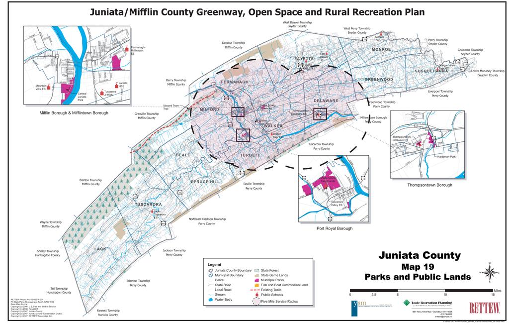
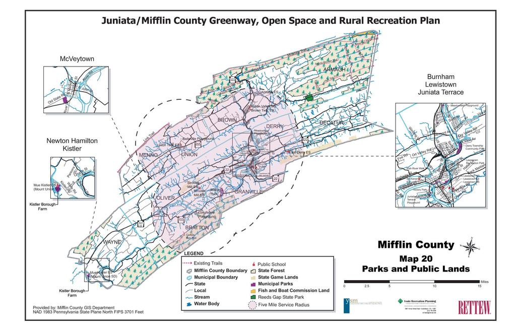
18 grow. The provision can not be used to make up for past deficiencies in parkland. Currently there are no municipalities in Juniata County and only one municipality in Mifflin County (Derry Township) with a mandatory dedication ordinance. To comply with this legislation, a municipality must meet the following requirements: 1. Adopt a recreation plan that establishes open space standards and park service areas, identifies areas in need of open space, and includes a capital improvement program. 2. Develop a mandatory dedication ordinance that contains standards for determining the portion of a development to be dedicated and the amount, if any, of fee to be paid in lieu of land. 3. Create a separate interest bearing account for the placement of any collected fees. No municipalities in either County have an adopted recreation plan and many municipalities do not have municipal ordinances. The municipalities could consider adopting this Juniata/Mifflin County Greenway, Open Space, and Rural Recreation Plan as their own plan to address this mandatory dedication requirement. The Counties could adopt a mandatory dedication ordinance as an amendment to their Subdivision and Land Development Ordinances, and this provision will then be required of constituent municipalities that have not adopted their own Subdivision and Land Development Ordinances. A model mandatory dedication ordinance is provided in Appendix D. Mandatory dedication is an important tool to provide recreation land to meet resident needs as a municipality grows. Requiring developers to dedicate land for recreation or provide fee in lieu of dedication relieves current residents from bearing the funding for future parkland necessitated by residential growth. Ordinances should be crafted to define the type, size, location, and configuration of lands that are acceptable for dedication. It is important that dedicated lands be suitable for use for their intended purpose, which is recreation and as such, limitations such as wetlands, stormwater management facilities, floodplain, and other limiting factors should affect only a small percentage of the total tract. Municipalities should also include an option for dedication of land for trail corridors as a mandatory dedication provision. As new residential areas are developed, trails within the development and linking to other destinations are important community assets. Location and Service Areas of Active Public land The s and Public Lands Maps for Juniata County and Mifflin County (pages 5-27 and 5-28) illustrate the locations of the larger public community and neighborhood parkland in the counties. In Juniata County there are five parks of at least five acres in size and in Mifflin County there are 12 parks in this category. A five-mile service radius, equating to an approximate 10 minute drive time was used to evaluate the park locations and consider ease of access to these park sites. The location of parkland is considered to determine if residents throughout the Counties have easy, convenient access to recreation opportunities. Distribution analysis of parks was completed for parks at least five acres in size. The five acre size was determined to be adequate to have the mix of facilities for residents to travel to use. Consider that a soccer field occupies approximately two and one half acres and a softball field is approximately two acres in size, necessitating a park in the five acre range to provide the mix of facilities needed to meet community need. The maps reveal that municipal parks and recreation lands are well located in population centers. In Juniata County, parkland for active recreation is located in the population centers along the Juniata River. Areas to the east and west fall outside of the service areas of these larger parks. Expansive, contiguous areas of protected public lands are located in the northwestern portion of County along the border with Mifflin County. In Mifflin County, municipal parks are clustered in the center of the County in the population centers along the Juniata River, Kishacoquilias Creek, and in Belleville. These active parks are complemented by State Forest lands to the southwest, northwest and northeast areas of the County and State Gamelands to the southeast and smaller municipal parks throughout the Counties. Kistler Borough Farm was not designated with a service radius because although it meets the parcel size criteria, only one facility is currently developed at the site. Chapter 5-16
19 In Juniata and Mifflin Counties, as is common across the Commonwealth, parkland has traditionally been provided by the Boroughs and in some instances the first-ring suburban communities. Mifflin County residents look to Lewistown Borough and Derry Township for much of their recreation needs. Likewise in Juniata County, Mifflin, Mifflintown, and Thompsontown Boroughs have long served the recreation needs of out-lying municipalities. This regional use of facilities is typical, but presents financial and personnel challenges for the host communities. land Opportunities The parkland acreage analysis revealed a shortfall in parkland in the Counties and numerous municipalities without any parkland. Acquisition of additional parkland may be challenging for communities for a variety of reasons to include financial, land availability, and capacity to develop and maintain a park. These challenges will require a creative approach to providing additional recreation opportunities and parkland for constituents. Strategies to address the parkland need include maximizing existing recreation land, developing school/community parks, redevelopment of derelict land, and creating regional parks. Existing Recreation Lands Instead of pursuing new tracts of land for park development, first explore opportunities to expand existing parkland through acquisition of contiguous acreage. Additionally, there are significant private parks, golf courses, and sporting clubs in the two Counties. Another strategy is to explore partnerships with private entities to maximize recreation benefit on existing recreation lands. School/Community Municipalities could partner with the school district to establish a school/community park by acquiring parkland adjacent to a school that can be used for both community recreation and education purposes. Working together and sharing facilities will maximize public benefit. School sites in both Counties should be evaluated for the opportunity to develop expanded shared facilities. Redevelopment Land Municipalities in the more developed areas should explore parkland opportunities associated with derelict sites. Unused or abandoned lands should be explored for redevelopment potential for public benefit as parkland. There are many successful examples of brownfield redevelopment into parkland. The US Environmental Protection Agency (EPA) has funding available for brownfield assessment and cleanup. Regional s Developing parks on a regional basis where one or more municipalities partner to create a regional park is an important strategy for providing needed parkland. Regional cooperation maximizes and shares resources, expands opportunities beyond what might be possible in a single municipal park, and is typically looked upon favorably by PA DCNR when ranking funding applications. While it is important to have easy access to recreation opportunities in every community, regional parks could address the special use facilities needs like skate parks and swimming pools while providing supplemental traditional fields and courts. When municipalities work regionally they are able to harness their collective resources, share management and operations responsibilities, and maximize their financial investment through cost sharing, and avoid unneeded duplication of facilities. Regional parks are typically larger and offer a diverse pallet of facilities and leisure opportunities that cannot be provided within a smaller community park. Reeds Gap State and other nearby state parks serve as regional parks for Mifflin County, serving residents from multiple jurisdictions. There are no examples of regional parks developed through municipal partnerships currently in either County. Regional parks are recommended for Juniata and Mifflin Counties to address, in part, the need for additional parkland and recreation facilities. The suggested locations for the regional parks considered municipal population projections, location of existing recreation facilities, location of important agricultural lands and targeted conservation lands, and geographic features such as ridgelines and the river that limit ease of access. Chapter 5-17
20 Three regional parks are suggested for each County. Site selection feasibility studies should be undertaken to define criteria for the park sites and potential locations. The following general locations as suggested for consideration: Juniata County - Southern Monroe/Northern Greenwood/Western Susquehanna Townships. Juniata County - Northeast Fermanagh/Northwest Fayette Townships. Juniata County - Central Milford/Northeast Beale Townships. Mifflin County Armagh Township, Reeds Gap State. Mifflin County - Northern Brown Township. Mifflin County Kistler Borough, Kistler Borough Farm. Creating regional parks is one strategy identified for protecting open space. Regional parks should be located adjacent to permanently protected lands, where possible, to expand resource protection benefits. In some instances, regional parks that may be located adjacent to State Forest or Game Lands may help to address fragmentation of resources and offer the opportunity to link to existing trails. Regional parks should be large enough to provide diverse recreation opportunities with areas for both active and passive recreation pursuits. A size range of acres is suggested, but size will be dependent upon the availability and characteristics of the land. Of the six regional parks suggested for Juniata and Mifflin Counties, two have specific locations suggested; Reeds Gap State in Armagh Township, Mifflin County and Kistler Borough Farm in Kistler Borough, Mifflin County. Reeds Gap State The decommissioning of the swimming pool initiated discussions in the community about the importance of the park and the roles its facilities play in the region. A Friends of Reeds Gap State support group is under consideration to spearhead improvements and support of the park. Working together in partnership, the State s staff and local Friends should explore opportunities to reinvent Reeds Gap State and expand it mission to be a regional destination and provider of unique recreation opportunities while continuing to fulfill its State mission as a resourcebased recreation destination. While the swimming pool has been closed, the support facilities remain and the idea of introducing a spray park with water spray toys, similar to Little Buffalo State in Perry County has been discussed in the community. This idea has merit as the bathhouse and concession stand remain as support facilities and a spray park would be a unique recreation facility in the twocounty area. Additionally, a spray park would provide some of the same leisure benefits as the recently decommissioned pool. Kistler Borough Farm Kistler Borough owns approximately 89 acres of land along the Juniata River. A portion of the land is currently leased to the Mount Union Baseball Boosters which contains a softball field and a second field is under construction. The remainder of the site is in agricultural fields with a lawn area for parking. The tract was originally deeded to the Kistler Municipal Authority which no longer exists and is now held by the Borough. The full tract offers the size, location, and configuration for a regional park to serve the western portion of Mifflin County. The parcel contains significant frontage on the Juniata River and could provide additional river access opportunities. A vegetated riparian buffer parallels the river and the remainder of the tract is split between woodlands and agricultural fields. The northwestern boundary of the tract is contiguous to the Mount Union-Kistler Elementary School, part of the Mount Union School District expanding the opportunity to develop the tract as a community recreation destination. Chapter 5-18


21 The site contains gently sloping open areas suitable for development of active recreation facilities as well as wooded areas compatible with passive recreation opportunities such as trails and picnic areas. The floodplain is a development consideration. A small unnamed tributary to the river traverses the site adding to the ecological diversity of the setting. The potential of developing a regional park at the site should be explored with Kistler Borough. If a partnership with the Borough for this purpose is feasible, a master plan should be completed for the tract to explore facility and activity area preferences and needs in the region. The master plan should include a public participation process. Funding for the master plan could be sought from PA DCNR. Recreation Facilities Recreation facilities are the fields, courts, paths, picnic areas, scenic areas, playground equipment, and other park features that recreation participants enjoy using. These facilities should be provided throughout the Counties to meet the local needs and demands of individuals, families, community groups, and organized adult and youth leagues. These needs and demands should be defined by current facility usage, input from users and the community at large, and should consider local and regional trends in recreation and leisure activities. Tables 5-3 and 5-4 on pages 5-6 through 5-8 provide the public facility inventory for Juniata County and Mifflin County municipal parks. By facility quantity alone, both Counties have the greatest number of ballfields followed by playgrounds than other type of facility. Recreation facilities in numerous parks need upgrades to meet the safety guidelines of the Consumer Product Safety Commission Guidelines for Public Playground Safety (CPSC) and the requirements of the Americans with Disabilities Act (ADA). The CPSC provides playground development criteria which address fall zones, safety surfacing, age segregation, and equipment spatial criteria. The ADA is civil rights legislation that mandates equal access to public facilities for persons with disabilities. s and recreation sites must meet the requirements of the ADA which include providing an accessible route to facilities, providing facilities that are accessible such as picnic tables and playground with play options for the physically challenged, providing accessible parking spaces, developing trails that meet specific slope criteria, among other requirements. Access to Special Use Recreation Facilities Environmental Education The public lands of the Counties provide many opportunities for nature-based recreation and the enjoyment of nature and the great outdoors. Currently students from the Mifflin County School District travel to Camp Blue Diamond in Huntingdon County for the Shaver s Creek Outdoor School once a year as a field trip. From a selfdirected standpoint, there are many opportunities to learn about nature and the environment without leaving Juniata or Mifflin Counties. The Counties natural resources present numerous opportunities for environmental education, although a formal setting Chapter 5-19
22 such as a nature center does not exist. The Pennsylvania Department of Education has established academic standards for Environment and Ecology. These standards establish the essential elements that students should know about the environment at designated grade levels. This environmental and ecological curriculum is often explored outside the classroom. Nature parks and nature centers offer hands-on learning experiences and their exhibits and facilities are often tied directly to the State Academic Standards. A nature center is not necessary to teach the curriculum and visiting parks such as Malta in Granville Township, Mifflin County where pavilions provide protected gathering space could meet this education need. If development of a formal nature center is pursued in the future, the location should be chosen based on consideration of the natural resources as well as travel time from school sites. River and Stream Access Access to the Juniata River for fishing and boating was noted as important by residents. The Upper Section and Lower Section of the Juniata River Water Trail contain a total of nine existing river access areas described below. Juniata County River Access Sites Thompsontown Pennsylvania Fish and Boat Commission (PFBC) surfaced ramp located along Route 333 south from Thompsontown on left before the bridge. Muskrat Springs PFBC surfaced ramp located 4.5 miles west of Thompsontown Borough at the end of Muskrat Spring Road. Walker PFBC-surfaced ramp located 1.5 mile east of Port Royal Borough on River Road. Mifflin Surfaced ramp located in Mifflin Borough at the eastern end of Tuscarora Street. Mifflintown PFBC-surfaced ramp located two miles north of Mifflintown Borough off of the 28 th Division Highway. Lewistown Narrows PFBC concrete ramp, parking, and accessible fishing area off of Route 322. A towpath trail extends approximately 1.5 miles along the river from this PFBC area to Canal. Mifflin County River Access Sites Victory PFBC surfaced ramp and handicapped accessible fishing pier located in Victory in Lewistown Borough off of Route 22. Locust Campground Primitive ramp located in the Locust Campground approximately 3 miles south west of Lewistown Borough on off of Locust Road. Granville PFBC surfaced ramp approximately 3 miles south west of Lewistown Borough off of North River Road next to the rail bridge. Newton-Hamilton PBFC concrete ramp located in Newton-Hamilton Borough off of Ferguson Valley Road. Shawmut Surfaced ramp located approximately three miles south of Newton- Hamilton Borough on Tuscarora State Forest lands off of Route 103. Tea Creek PFBC fishing access area. Another potential access area in Mifflin County could be located in the proposed Fort Granville Heritage outside of Lewistown. In Mifflin County there is a separation of 22 miles of river between the Granville and Newtown-Hamilton access points. Coupled with the desire for river access is access to streams for fishing. Juniata and Mifflin Counties are fortunate to have numerous high quality water courses and streams known for quality trout fishing. Unfortunately, the trend is toward private landowners limiting general public access to these resources. Additional river and stream public access areas should be sought, targeting a minimum separation of approximately five miles between access points. Chapter 5-20
23 Non-Traditional Recreation Traditional park development typically serves youth who are interested in sports and organized activities very well. Ball fields and game courts are often the only facilities developed in addition to playgrounds when funds or space are limited. This reality often leaves youth interested in non-traditional activities such as skate boarding or in-line street hockey without opportunities for recreation. It is important to offer these non-traditional facilities as part of the mix of recreation opportunities to address the varied interest and engage youth in positive leisure-time activities. The regional parks may present an opportunity for development of non-traditional recreation facilities. Public Opinion Survey In 2007, as part of the planning process, a random public opinion surveys were sent to residents of Juniata and Mifflin Counties. In the surveys, Juniata and Mifflin residents were asked to rate their level of satisfaction with existing recreation facilities in the Counties, identify which recreation facilities they felt were most important, rate their preference for park type, and rate which priorities the future focus of open space conservation in the Counties should concentrate. A summary of the results are described below and in Chapter 2. Evaluation of the Quality of Existing and Recreation Facilities by County The majority of Juniata County respondents felt that safety was the best quality of the existing park and recreation facilities in the County, followed closely by the location of parks and the cleanliness of the parks. The majority of Mifflin County respondents felt that cleanliness was the best quality of existing park and recreation facilities in the County, followed by the recreation programs offered and the overall impression of facilities in the County. The fewest respondents of Juniata County felt the variety of recreation facilities and recreation programs was their best quality while Mifflin County ranked safety and variety of facilities lowest of the quality ratings. Preferred Type by County Nature preserves were the preferred park type of respondents from Juniata County, followed by greenways. Smaller, closer to home parks were the most preferred park type by respondents from Mifflin County, followed by nature preserves. The fewest respondents in both Juniata and Mifflin Counties considered countywide bicycle trails as their preferred recreation park type. Priorities for Future Focus for Open Space Conservation, s, and Recreation Preferred open space conservation priorities for both Counties were maintaining existing parks, natural resource conservation, and open space protection. New park development and create trails ranked lowest in both Counties. Importance of Recreation Facilities by County Over 70-percent of respondents from both Counties felt that public forests were the most important public open space asset, followed by natural areas. The fewest respondents felt that biking paths were important recreation facility to have in the two Counties. The results of the public opinion survey provide valuable information as it sets a baseline on which to measure satisfaction levels with existing facilities in Juniata and Mifflin Counties. The survey results assist in setting priorities for the future recreation and open space priorities as Juniata and Mifflin Counties implement the Greenway, Open Space and Rural Recreation Plan. Pilot Projects Resident of Juniata and Mifflin Counties enjoy close to home recreation opportunities in municipal parks or parks offered by community organizations. Many Chapter 5-21
24 of the parks of Juniata and Mifflin Counties were viewed as a part of this planning process. While an assessment of each park was not completed, observation from the site visits revealed numerous opportunities to expand the public benefit of these facilities. Four pilot parks have been identified to illustrate development and enhancement opportunities that may be compatible with other parks throughout the Counties. Juniata Terrace Borough s, Mifflin County East End Playground and West End Playground are small neighborhood parks at either end of Terrace Boulevard in Juniata Terrace Borough. The parks offer play equipment and lawn area. Assessment and recommendations include: The parks target the recreation needs of one user group: youth. The small size of the sites is a limiting factor. Play equipment - The equipment includes older models that should be tested to assure compliance with the Consumer Product Safety Commission guidelines for playground safety. A cursory review of play equipment revealed issues with non-compliant equipment and lack of safety surfacing. Safety surfacing is required throughout the safety zones. Safety surfacing mulch or resilient pavement should be installed to meet fall criteria and accessibility requirements. - Playgrounds must meet the requirements of the Americans with Disabilities Act (ADA) which requires that an accessible route be provided from walkways/parking areas to the playground equipment and that a portion of the equipment offer activities that can be utilized by physically challenged children. and abilities. Typically, play areas are divided to accommodate two to five year olds in one area and six to 12 year olds in a separate area. - Playgrounds should be designed to stimulate imaginative play as well as physical activity. Playgrounds should be bright, stimulating environments that engage children while providing convenience facilities for adults such as benches and shaded areas. Locate playgrounds for safety. Provide adequate separation from streets, parking areas, and where applicable other recreation facilities such as ballfield foul ball and home run territory. The site should be accessible to persons with disabilities. An accessible route is required to provide access to the play equipment from the sidewalks. An accessible parking space should be provided if room exists. Site amenities should be added to enhance the convenience of using the parks. Benches for caregivers, picnic tables, trash receptacles, and bike racks are facilities that should be installed throughout the park sites. Shade is an important aspect of creating a comfortable outdoor environment, especially for seniors. Shade trees should be located with benches for shaded seating opportunities. If room is available, a small pavilion for one to two picnic tables should be provided for additional shade. Adding a small pavilion will also expand the use of the park. A master plan should be completed to address the assessment recommendations and to develop a design for the two parks that targets community needs and maximizes recreation opportunity. - Playgrounds should be age segregated to accommodate children of different ages Chapter 5-22


25 Fort Granville Heritage, Mifflin County Fort Granville Heritage is an 8.8 acre site in Granville Township that has been suggested as a possible park redevelopment project. Preliminary conceptual plans for the parcel include river access, a playground, picnic areas, walking trails, and parking. Remediation of the on-site soils will be necessary as identified in the Phase II Environmental Assessment for the site. Rehabilitation of the site which is entirely in the floodplain would reuse a long vacant parcel and introduce a public recreation amenity in close proximity to the County s major population area. The location along the Juniata River will provide a scenic amenity as well as a desired additional access point. Potential to connect the park to the Kish RiverWalk via the construction of a footbridge connected to an old railroad bridge spanning the Juniata River is also envisioned for the park. The Conceptual Site Redevelopment Plan completed by ARM Group Inc. is provided below. Lehman Covered Bridge, Port Royal Borough and Milford Township, Juniata County Moyer in Port Royal Borough and Lions Club in Milford Township are located approximately 1.25 miles apart along the Tuscarora Creek and Licking Creek riparian corridors. Midway between these two existing parks is the Lehman Covered Bridge, a historic structure that spans Licking Creek carrying Milford Street. The bridge is on the National Register for Historic Places and is privately owned. Both parks offer Chapter 5-23


26 game courts and play areas. The land use between the two parks along the stream corridors is primarily agricultural with riparian vegetation at the stream. A bicycle and pedestrian trail is suggested to connect the two park sites. The trail would cross the covered bridge to gain access to the both sides of the creek. A small park area is suggested at the covered bridge which could offer a resting area along the trail and interpretative signs. Safety measures will be required at the Routes 75/ 333 crossing. A study is required to determine if the suggested park and trail improvements can be undertaken. Land ownership, physical configuration and constraints, development options, and public interest in the project should be explored through a feasibility study. If the project is feasible, a master plan should be completed to develop the specific design of the improvements. Academia Pomeroy Covered Bridge, Beale Township, Juniata County fishing, and areas and facilities for the passive enjoyment of the outdoors. The amount of land that can be secured for public use will determine if additional facilities can be developed and a master plan should define the specific improvements proposed. Conclusions Strengths Juniata and Mifflin Counties have bountiful outdoor recreation opportunities. The nearly 100,000 acres of conservation and park lands offer opportunities for a wide variety of outdoor activities from hunting and fishing to picnicking, nature study, hiking, and traditional activities like participating in organized sports leagues and visiting playgrounds. Easy access to the great outdoors is available to all who live in the Counties. The historic and cultural remnants of the County s past provide compelling stories that can be interwoven into recreation experiences today. Challenges The historic Academia Pomeroy Covered Bridge in Beale Township was restored in 2008 and 2009 by the Juniata County Historic Society. The bridge spans 271 feet 6 inches across the Tuscarora Creek and is the longest remaining covered bridge in Pennsylvania. The bridge is on the National Register of Historic Places and is owned by the Juniata County Historical Society, although the land surrounding the bridge is in private ownership. The significance of the historic structure, the recent investment, and the location in an underserved portion of the County offer a compelling rationale for the development of a public park at the bridge site. Ownership of the surrounding land and the willingness of the owners to sell the land or execute an easement or long term lease on the property are the first issues to be explored. If a park is possible in this area components of the facility should include historic interpretation signage, creek access for Although the Counties have many pieces of a comprehensive park system, key components are missing or unrealized and there are significant challenges associated with providing close to home parks and recreation lands to serve residents. Consider the following: The approximately 420 acres of local parkland for close-to-home recreation falls short of the nearly 700 acres needed now and approximately 770 acres needed by Neither County has formalized a county park system. Mifflin County has the oneacre Stone Arch Bridge while Juniata County has no county parkland. A parks department is not recommended for either County although the Counties could consider working together, along with the host municipalities to promote recreation on a regional basis. Table 5-14 on page 5-26 defines a typical park classification system that should be considered for a bi-county Chapter 5-24
27 system. County-owned parks, heritage sites, and other similar public lands should be manage and maintained in partnership with another entity such as a municipality or historic society. Canal associated with the Lewistown Narrows Route 322 improvements may be transferred to the Counties and a partnership with the hosting municipality should be explored. There are 11 municipalities without a park. s and recreation opportunities are essential elements of a high quality of life. Providing recreation opportunities for individual leisure pursuits, family gatherings, community celebrations, competitive sports, and playground programs are important aspects of creating and maintaining a sense of community and providing fitness and wellness benefits to citizens. Opportunities The existing parks, school sites, and other public lands present opportunities to expand the offering of recreation facilities to County residents. Additional parkland has been identified as a need, and opportunities exist to expand the parkland holdings through partnerships with school districts and collaborative efforts between municipalities and public agencies. The rivers and historic and cultural resources of the Counties present interesting portals into the Counties past and opportunities to create destination parks that draw visitors to the area while meeting residents recreation needs. Juniata and Mifflin Counties have yet to witness the extensive development that has affected many other areas of the Commonwealth. This position provides opportunity for parkland acquisition and exploration of partnerships that will promote broad recreation benefits to the citizens of the Counties. Municipalities have limited financial resources for parkland acquisition, including matching funds for acquisition grants. Personnel resources for maintenance of parkland are equally challenged. All but one of the municipalities in Juniata and Mifflin Counties do not have mandatory dedication ordinances that provide for dedication of parkland from developers. Key recreation facilities are missing from the offerings in the Counties to include a park or nature center developed for environmental education, convenient access to the river and streams throughout the Counties, and special use facilities such as skate parks. The Boroughs and first-ring suburban communities have long provided the majority of parkland and recreation opportunities, serving as regional facilities. This informal regional approach to parks and recreation places excessive financial and personnel burden on these core providers. Chapter 5-25
28 Type/Size/ Service Radius Mini 0-5 acres ¼-mile service radius Neighborhood 5-15 acres minimum ½-mile service radius Community acres, preferably acres 2-mile service radius School/ Community Variable Sports Complex 30+ acres; preferably acres Special Use Facility Variable Greenways and Trails Variable Natural Resource Area/ Preserve Table 5-14 Typical Classification System Definition Benefits Appropriate Amenities Maintenance Level Smallest park type, addresses limited recreation need Focus of neighborhood; in walking/biking distance of visitors Large park for active & passive recreation; serves residents municipalitywide. Accommodates large groups. land adjoining a school used for both recreation and education. Consolidates sports fields and related facilities in a centralized location. Facility for a single purpose use. Tie park areas and community together to form a contiguous park environment. Natural areas for the protection and management of natural environment Provides close-to-home recreation Provides access to basic recreation opportunities Contributes to neighborhood identity Establishes sense of community Variety of recreation opportunities for all ages and interests Space for organized, large scale, high participation events Family destination Fitness and wellness opportunities Combines two public entities for expanded year round recreation. Maximizes public resources Expands recreation opportunities Economy of scale Improved management Municipal showcase Attracts visitors who stimulate local economy Provides special focus recreation opportunities Contributes to community identity Connects community Reduces auto dependency Improves air quality Contributes most desired recreation facility for people throughout their lifetime Attracts visitors Protects resources Provides wildlife habitat Offers opportunities for environmental education Playground Benches, seating area Play areas Ball fields Game Courts Picnic/Seating Pathways Community gardens Play areas Organized sports facilities Pavilions Permanent restrooms Lighting Amphitheaters Pools, Rinks ing Youth-oriented game courts and ball fields Play areas Seating Pathways Lighting ing Ball fields Lighting Spectator areas Restrooms, Concessions Landscaping ing Depends on purpose Pathways multipurpose Trailheads Support facilities Signage Trails Signage Support facilities High level of maintenance associated with well developed park and playground and reasonably high visitation High level of maintenance associated with welldeveloped park and reasonably high visitation. Moderate level of maintenance associated with moderate level of development, budget restrictions, inability to perform higher levels of maintenance. Potential for park friends or adopt-apark partners. Moderate level of maintenance associated with moderate level of development, budget restrictions. Potential for cooperative agreement with school. State of the art maintenance applied to high quality facilities. Associated with high visitation; revenue generating facilities, tourism. High level of maintenance associated with welldeveloped park and reasonably high visitation. Lowest level of maintenance. Focus on trailheads and trail safety. Lower level of maintenance. Chapter 5-26
29
30
!44. Clinton County. New TIP Project - Bridge. New TIP Project - Road. Carryover TIP Project - Bridge. Carryover TIP Project - Road LYCOMING COUNTY
 POTTER 92421 CAMERON!144 3797!120 3808 110355 110354 4601!144 93274 93272 220 CLEARFIELD 93343 93303 3850 109872 4601 93301!44 Clinton County 1 inch = 355 miles 1:224,942 Lock Haven 69422 105918 89985
Introduction Parks Open Space Standards Recreation & Open Space Land Use Design Principles
 Chapter Seven: Parks, Recreation, & Open Space Chapter Seven: Parks, Recreation, & Open Space Introduction Parks Open Space Standards Recreation & Open Space Land Use Design Principles September 2008 Page
Bridge Map !44 !120. Clinton County LYCOMING COUNTY CAMERON COUNTY CLEARFIELD COUNTY CENTRE COUNTY. Local Bridge Prioritized Structure
 POTTER CMERON Leidy 144 Chapman 3797 69493 East Keating 93317 Renovo 12394 South Renovo 034 120 03 690 Noyes Gallagher 946 4601 Grugan Williamsport West Keating 144 Colebrook 389 220 93274 93272 Pine Creek
Overview Open Space and Recreation
 Overview Open Space and Recreation Open Space Plan (2004) Environmental Priority Areas Town Character Priority Areas Recreational Facilities maintained by the Town RSU 21 Recreational Facilities in Kennebunk
Multi-Jurisdictional Hazard Mitigation Plan
 Flooding General Flooding is the leading cause of death among all types of natural disasters throughout the United States, with its ability to roll boulders the size of cars, tear out trees, and destroy
 Time of Change We Are Growing We Are An Attractive Place To Live We Are Age Diverse + Living Longer 50000 40000 30000 20000 10000 0 2010 Census Job Density Housing Sheds Transit Sheds The Project FUNDING
CITY OF COCOA BEACH 2025 COMPREHENSIVE PLAN. Section VIII Mobility Element Goals, Objectives, and Policies
 CITY OF COCOA BEACH 2025 COMPREHENSIVE PLAN Section VIII Mobility Element Goals, Objectives, and Policies Adopted August 6, 2015 by Ordinance No. 1591 VIII MOBILITY ELEMENT Table of Contents Page Number
Perryville TOD and Greenway Plan
 Perryville TOD and Greenway Plan Greenway Glossary Pathway: A bicycle and pedestrian path separated from motorized vehicular traffic by an open space, barrier or curb. Multi-use paths may be within the
Guidelines for Public Use of WPC-owned Properties. Last revised 01/27/2017
 Guidelines for Public Use of WPC-owned Properties Last revised 01/27/2017 Properties owned by Western Pennsylvania Conservancy (WPC) are open to the public free-of-charge. Western Pennsylvania Conservancy
Chapter 5 Future Transportation
 Chapter 5 Future Transportation The Future Land Use Plan identifies the desired land use designations. The land uses desired for Crozet depend, in large part, on the success of the transportation system,
FAYETTE COUNTY. Fayette County Active Transportation Profile REGIONAL ACTIVE TRANSPORTATION PLAN FOR SOUTHWESTERN PENNSYLVANIA
 REGIONAL ACTIVE TRANSPORTATION PLAN FOR SOUTHWESTERN PENNSYLVANIA 1 2 ACTIVE TRANSPORTATION AT A GLANCE Trails + Bike Routes 4 miles 73 miles 130 miles 90 miles Parkland Parkland Trail Off Street Trail
Wellsville Recreational, Sporting and Outdoor Resources Summary
 Island Park Located off NYS 417 across from West Dyke Street Owned by the Village of Wellsville; Maintained by the Town of Wellsville Sporting Facility with Little League Field in it; pavilions, trails,
Spearfish Canyon State Park & Bismarck Lake
 Spearfish Canyon State Park & Bismarck Lake Land Exchange Between the U.S. Forest Service and the State of South Dakota July 12, 2016 Background In 2006, the State of South Dakota received title to several
Executive Summary Route 30 Corridor Master Plan
 Route Corridor Master Plan Project Overview The Route Corridor Master Plan is a coordinated multimodal transportation and land use plan for the entire stretch of Route through East Whiteland Township,
2014 PA Resident Survey
 2014 PA Resident Survey Purpose: Understand outdoor recreation patterns and opinions regarding future recreation land conservation, facility development and management Provide a snapshot of where Pennsylvanians
BASS LAKE PLANNING UNIT Willow Creek Watershed
 Existing Conditions & Uses Overview Reservoir that is a popular summer recreation destination, with substantial residential and recreation development 1,085 acres in Madera County; 149 acres outside and
EXISTING CONDITIONS. Chapter General Overview
 GRAHAM PEDESTRIAN TRANSPORTATION PLAN Chapter 2 T 2.1 General Overview he City of Graham is the Alamance County Seat, located within the Piedmont Triad section of North Carolina. About halfway between
Corpus Christi Metropolitan Transportation Plan Fiscal Year Introduction:
 Introduction: The Safe, Accountable, Flexible, Efficient Transportation Equity Act: A Legacy for Users (SAFETEA-LU) has continued the efforts started through the Intermodal Surface Transportation Efficiency
Bicycle and Pedestrian Facilities Toolbox (Excerpt from Figure 3.1)
") Appendix B Neighborhood Connections Summaries This Appendix is a supplement to the information presented in Chapter 3 Connect People. The Appendix includes a summary or profile for each of the proposed
Appendix B Neighborhood Connections Summaries This Appendix is a supplement to the information presented in Chapter 3 Connect People. The Appendix includes a summary or profile for each of the proposed
Page 1. To: City of Durango - Parks and Recreation Advisory Board - Natural Lands Preservation Advisory Board Highland Avenue Durango, Colorado
 Page 1 To: City of Durango - Parks and Recreation Advisory Board - Natural Lands Preservation Advisory Board From: John Norton 2009 Highland Avenue Durango, Colorado Date: October 27, 2014 Regarding: Natural
Key Findings from a Statewide Survey of Wyoming Voters October 2018 Lori Weigel
 Key Findings from a Statewide Survey of Wyoming Voters October 2018 Lori Weigel #181147 2 Partners Involved Methodology A statewide survey of 600 registered voters throughout Wyoming conducted on both
City of Brandon Recreation Facilities Master Plan
 2.7 Specialty Recreation (Refer to Map 1F, Page 55) Specialty Recreation combines: Skateboarding, Snowboarding, and BMX Riding. All of these recreation types have specific facility requirements that in
Visitor Guidelines for WPC-owned Properties. Last revised 5/20/2010
 WESTERN PENNSYLVANIA CONSERVANCY Visitor Guidelines for WPC-owned properties 800 Waterfront Dr., Pittsburgh, PA 15222 412-288-2777, www.waterlandlife.org Visitor Guidelines for WPC-owned Properties Last
Rabbit Lake. Recreational Trail. Tour Guide
 Rabbit Lake Recreational Trail Tour Guide Rabbit Lake Trail RABBIT LAKE RECREATIONAL TRAIL HISTORICAL WALKING TOUR The Rabbit Lake Trail system is partially inclusive, accessible and paved. This trail
BIKE PLAN CONTENTS GATEWAY
 CONTENTS Acknowledgments...vii Great Rivers Greenway District Board of Directors... vii Great Rivers Greenway District Staff... vii Project Consultants... vii Committees... viii Citizens Advisory Committee
APPENDIX 1 QUESTIONNAIRE RESULTS
 APPENDIX 1 QUESTIONNAIRE RESULTS NORTHERN BERKS REGION PLANNING QUESTIONNAIRE 1. From 1990 to 2000, the population of the Northern Berks Region grew from 11,810 to 13,372, a 13.2% increase. In the future,
Blue River Restoration Project
 Blue River Restoration Project Blue River Restoration Project BUI LDI NG BRI DGES BETWEEN COMMUNI TI ES I N COOPERATI ON WI TH THE NATI ONAL FOREST FOUNDATI ON The Blue River Restoration project is an
Assemblymember Phil Steck and Mayor Gary McCarthy Announce Upgrades to Schenectady Central Park
 Gary R. McCarthy Mayor OFFICE OF THE MAYOR CITY OF SCHENECTADY NEW YORK City Hall, 105 Jay Street, Rm 111 Schenectady, N.Y. 12305-1938 Office: (518) 382-5000 Cell: (518) 424-0483 Fax: (518) 382-5272 gmccarthy@schenectadyny.gov
3.9 Recreational Trails and Natural Areas
 3.9 Recreational Trails and Natural Areas 3.9.1 Introduction Parks and other recreational facilities such as trails, bicycle routes, and open space are important community resources. This section discusses
Resident Outdoor Recreation for Fremont County, WY July 1999
 UNIVERSITY OF WYOMING 'P.O. Box 3354 Cooperative Extension Service Laramie, WY 82071-3354 College of Agriculture Phone: 307-766-2386 Department of Agricultural and Applied Economics Fax: 307-766-5544 Resident
Hunting, Fishing, Recreational Shooting, and Wildlife Conservation Opportunities and Coordination with States, Tribes, and Territories
 THE SECRETARY OF THE INTERIOR WASHINGTON ORDER NO. 3356 Subject: Hunting, Fishing, Recreational Shooting, and Wildlife Conservation Opportunities and Coordination with States, Tribes, and Territories Sec.
Handbook. Mountain Brook Parks and Recreation Bethune Drive Mountain Brook, AL
 Mountain Brook Parks and Recreation Handbook Mountain Brook Parks and Recreation 3698 Bethune Drive Mountain Brook, AL 35223 www.mtnbrook.org 1 2 Mountain Brook Parks and Recreation Handbook This handbook
Sport Fishing Expenditures and Economic Impacts on Public Lands in Oregon
 Sport Fishing Expenditures and Economic Impacts on Public Lands in Oregon For: Northwest Sportfishing Industry Association By: Southwick Associates October 2013 PO Box 6435 Fernandina Beach, FL32035 Tel
East Burke Transportation, Safety and Capacity Improvements
 East Burke Transportation, Safety and Capacity Improvements The purpose of this project is to increase mobility and improve safety for pedestrians, cyclists, and motor vehicles along VT Route 114 in the
8 Bicycle and Pedestrian Facilities
 8 Bicycle and Pedestrian Facilities 8.1 Existing Facilities The facilities available to walkers and bikers are diverse in the rural ACOG area. Walking and biking are, by their nature, localized modes of
Chapter 7. Transportation. Transportation Road Network Plan Transit Cyclists Pedestrians Multi-Use and Equestrian Trails
 Chapter 7 Transportation Transportation Road Network Plan Transit Cyclists Pedestrians Multi-Use and Equestrian Trails 7.1 TRANSPORTATION BACKGROUND The District of Maple Ridge faces a number of unique
Vision: Traditional hamlet with an attractive business/pedestrian friendly main street connected to adjacent walkable neighborhoods
 N D. Focus Area II Vision: Traditional hamlet with an attractive business/pedestrian friendly main street connected to adjacent walkable neighborhoods Transit Road Focus Area II is located in the Hamlet
III BASIN DESCRIPTION
 III-1 III BASIN DESCRIPTION The Youghiogheny Basin covers 1768 sq mi and extends from northern Maryland to McKeesport, Pennsylvania. This report deals only with the 1,255 sq mi of the basin within Pennsylvania
Blue River Restoration Project William D. Linfield, P.E.
 Blue River Restoration Project William D. Linfield, P.E. 1 2 3 4 5 Blue River Restoration Project BUILDING BRIDGES BETWEEN COMMUNITIES IN COOPERATION WITH THE NATIONAL FOREST FOUNDATION Building Bridges
2018 WILDLIFE MANAGEMENT PLAN
 2018 WILDLIFE MANAGEMENT PLAN 1 MEMORANDUM TO: FROM: Captain Daniel Wills Officer Dominic Wareham DATE: July 11, 2018 RE: 2018 Wildlife Management Plan CONTENTS I. 2017 Wildlife Management Report II. 2017
PASSENGER RAIL STATION LOCATION AND DESIGN WORKING GROUP MEETING STOCKBRIDGE
 PASSENGER RAIL STATION LOCATION AND DESIGN WORKING GROUP MEETING STOCKBRIDGE Criteria for Passenger Rail Station Location Municipal Level To objectively compare Target Areas in all communities along the
summary of issues and opportunities
 1 summary of issues and opportunities EXECUTIVE SUMMARY CHAPTER 2: HISTORY - 3: LAND USE This first chapter is an overview of lessons learned from analysis of the existing conditions on El Camino as well
This page intentionally left blank.
 This page intentionally left blank. COMMUNITY Glenpool Community Overview Glenpool Glenpool is a city of nearly 12,000 residents located in Tulsa County southwest of Tulsa and Jenks. The city is growing
PEDESTRIAN NETWORK PLAN
 GRAHAM PEDESTRIAN TRANSPORTATION PLAN Chapter 3 A 3.1 Overview new pedestrian network plan for the City of Graham has been developed based on an examination of the existing conditions (Chapter 2) and an
CONNECTING PEOPLE TO PLACES
 CONNECTING PEOPLE TO PLACES 82 EAST BENCH MASTER PLAN 07 Introduction The East Bench transportation system is a collection of slow moving, treelined residential streets and major arteries that are the
Downtown Lot with no Zoning WISDOM, MT
 Downtown Lot with no Zoning WISDOM, MT Katey Brandenberger, Sales Associate Katey.brandenberger@prumt.com Agent cell # (406) 370-3016 Office: (406) 689-3190 www.prumt.com Wisdom River Gallery PO Box 93
City of Novi Non-Motorized Master Plan 2011 Executive Summary
 City of Novi Non-Motorized Master Plan 2011 Executive Summary Prepared by: February 28, 2011 Why Plan? Encouraging healthy, active lifestyles through pathway and sidewalk connectivity has been a focus
ALLEGHENY COUNTY. Allegheny County Active Transportation Profile 2017 REGIONAL ACTIVE TRANSPORTATION PLAN FOR SOUTHWESTERN PENNSYLVANIA
 REGIONAL ACTIVE TRANSPORTATION PLAN FOR SOUTHWESTERN PENNSYLVANIA 1 2 ACTIVE TRANSPORTATION AT A GLANCE Trails + Bike Routes 123miles 132 miles 281 miles 75 miles 3 FACILITIES Facility Metrics (not including
Notice. Proposed Changes to List of Class A Wild Trout Waters January 2019
 Notice Proposed Changes to List of Class A Wild Waters January 209 The Fish and Boat Commission (Commission) is considering changes to its list of Class A Wild Streams. Under 58 Pa. Code 57.8a (relating
Township of Plainsboro Ordinance No County of Middlesex AN ORDINANCE ESTABLISHING A DEER MANAGEMENT PLAN ON CERTAIN PUBLIC PROPERTY
 Township of Plainsboro Ordinance No. 18-10 County of Middlesex AN ORDINANCE ESTABLISHING A DEER MANAGEMENT PLAN ON CERTAIN PUBLIC PROPERTY WHEREAS, White-tailed deer populations have been increasing and
Outreach Sessions for the Transportation Plan Update. April 29, May 13, and May 20
 Outreach Sessions for the Transportation Plan Update April 29, May 13, and May 20 Our Transportation Plan Identifies projects that will improve travel for our citizens and businesses over the next 25 years
2016 Volunteer Program Annual Report
 The mission of the Oregon Department of Fish & Wildlife Volunteer Program is to actively involve citizens as volunteers in the protection and enhancement of Oregon s fish and wildlife resources for the
Develop a Multi-Modal Transportation Strategy (Theme 6)
") DEVELOP A MULTI-MODAL TRANSPORTATION STRATEGY (THEME 6) WHY IS THIS THEME ADDRESSED? Develop a Multi-Modal Transportation Strategy (Theme 6) Statement of Ideal Reduce resident and visitor reliance on single
DEVELOP A MULTI-MODAL TRANSPORTATION STRATEGY (THEME 6) WHY IS THIS THEME ADDRESSED? Develop a Multi-Modal Transportation Strategy (Theme 6) Statement of Ideal Reduce resident and visitor reliance on single
APPENDIX G: INTERSECTION NEEDS AT OKEECHOBEE BOULEVARD
 APPENDIX G: INTERSECTION NEEDS AT OKEECHOBEE BOULEVARD INTERSECTION NEEDS AT SR 7 and OKEECHOBEE BOULEVARD SR 7 Extension Project Development and Environment (PD&E) Study From Okeechobee Boulevard (SR
Albany County, Wyoming
 Albany County, Wyoming Western Land Sales 123 South 12th Street Thermopolis, WY 82443 www.westernland.net Roy Ready 307-234-2211 J.R. Kvenild 307-259-5000 China Wall Ranch Albany County, WY LOCATION &
TRANSPORTATION & MOBILITY
 TRANSPORTATION & MOBILITY ROADWAY SYSTEM There are approximately 40 miles of roadways in Manitou Springs. For planning purposes, roadways are typically assigned a functional classification which defines
Chagrin River TMDL Appendices. Appendix F
 Appendix F The following are excerpts from the Eastern Brook Trout Joint Venture s Conservation Strategy (Working Draft v.6), Conserving the Eastern Brook Trout: Strategies for Action Found at: http://www.easternbrooktrout.org/constrategy.html
Developing a Bike/Pedestrian Plan Using ArcInfo and Public Participation Rob Shumowsky, Madison County Council of Governments
 Developing a Bike/Pedestrian Plan Using ArcInfo and Public Participation Rob Shumowsky, Madison County Council of Governments Abstract: The Madison County Council of Governments is creating a bike/pedestrian
STRATEGIC PLANNING FOR DEVELOPMENT OF THE OREGON SHORT LINE TERMINUS HISTORIC DISTRICT
 STRATEGIC PLANNING FOR DEVELOPMENT OF THE OREGON SHORT LINE TERMINUS HISTORIC DISTRICT & AN EXECUTIVE SUMMARY OF THE HEART OF WEST YELLOWSTONE CONCEPTUAL PLANNING REPORT November 2004 PREPARED BY The Portico
FACILITIES PUBLIC FEEDBACK
 FACILITIES PUBLIC FEEDBACK tennis outdoor basketball court camper/rv hook-ups beach area along lake croquet lawn interpretive trails putting green horseshoe pits wellness stations sand volleyball courts
T W P L A I A A V O L H S Bike Network Plan Sylvania, Ohio. July 20, 2009
 Y 2009 E T W O R K N P L A E N K I B N I A A V O L H S O I 2009 Bike Network Plan Sylvania, Ohio I-75 Lenawee County US 23 Monroe County I-75 Michigan Ohio SYLVANIA Alexis Rd I-475 Monroe 24 I-75 20/120
Non-Motorized Transportation 7-1
 Non-Motorized Transportation 7-1 Transportation facilities no longer mean just accommodating a vehicle powered by a combustion engine. Pedestrian and non-motorized facilities are important modes of travel
CITY OF ELKO BICYCLE AND PATHWAY PLAN
 CITY OF ELKO BICYCLE AND PATHWAY PLAN INTRODUCTION: The City of Elko is intended to provide the basic framework for the development of a functional bicycle and pathway system for the community with connections
Solana Beach Comprehensive Active Transportation Strategy (CATS)
") Solana Beach Comprehensive Active Transportation Strategy (CATS) 3.0 Goals & Policies The Solana Beach CATS goals and objectives outlined below were largely drawn from the Solana Beach Circulation Element
Solana Beach Comprehensive Active Transportation Strategy (CATS) 3.0 Goals & Policies The Solana Beach CATS goals and objectives outlined below were largely drawn from the Solana Beach Circulation Element
Goal 3: Foster an environment of partnerships and collaboration to connect our communities and regions to one another.
 Non-Motorized Transportation Plan (NMTP) Draft Vision, Goal and,, Tri-County Regional Planning Commission (TCRPC) Purpose The purpose of the Tri-County Regional Planning Commission (TCRPC) Non-Motorized
Chapter 5 FUNCTIONAL CLASSIFICATION
 Chapter 5 FUNCTIONAL CLASSIFICATION Functional classification is a system by which streets and roadways may be distinguished by types according to their function within the entire transportation network.
CITY OF PITTSBURGH. City of Pittsburgh Active Transportation Profile REGIONAL ACTIVE TRANSPORTATION PLAN FOR SOUTHWESTERN PENNSYLVANIA
 REGIONAL ACTIVE TRANSPORTATION PLAN FOR SOUTHWESTERN PENNSYLVANIA 1 2 ACTIVE TRANSPORTATION AT A GLANCE Trails & Bike Routes 270 miles 28 miles 41 miles 24 miles 3 F A C I L I T I E S Facility Metrics
Overview. Existing Conditions. Corridor Description. Assessment
 Overview A study of the 23 rd Street corridor was undertaken to document the existing conditions, analyze traffic operations, and recommend remedies for deficient situations Although 23 rd Street is frequently
Ideas for Growing your Coalition: What kinds of groups join Teaming with Wildlife?
 Ideas for Growing your Coalition: What kinds of groups join Teaming with Wildlife? The Step-by-Step Guide to Building Your Coalition (www.teaming.com/pdf/step_by_step_guide.pdf) provides advice on getting
REMOVE BARRIERS TO, ENCOURAGE CREATION OF AND PROVIDE GUIDELINES FOR SAFE ROUTES (ALL DISTRICTS)
") Ordinance 2009-98 AN ORDINANCE OF THE BOARD OF SUPERVISORS OF PIMA COUNTY, ARIZONA; RELATING TO ZONING; AMENDING THE PIMA COUNTY ZONING CODE TITLE 18 BY AMENDING SECTION 18.03.020 (DEFINITIONS) TO ADD
Ordinance 2009-98 AN ORDINANCE OF THE BOARD OF SUPERVISORS OF PIMA COUNTY, ARIZONA; RELATING TO ZONING; AMENDING THE PIMA COUNTY ZONING CODE TITLE 18 BY AMENDING SECTION 18.03.020 (DEFINITIONS) TO ADD
Areas for Redevelopment or New Development:
 Small Group Exercise Summary Areas for Redevelopment or New Development: 1. Downtown a. Job Resource Center b. Community Activities / Activities to draw youth & millennials c. Need for additional parking
Wild Virginia and Heartwood first raised this issue at the May 19, 2014 public meeting.
 June 13, 2014 Karen Stevens Pat Sheridan, District Ranger Warm Springs Ranger District 422 Forestry Road Hot Springs, VA 24445 karenlstevens@fs.fed.us psheridan@fs.fed.us re: Lower Cowpasture Restoration
IMPLEMENTING REGULATIONS OF THE WILDLIFE CONSERVATION LAW. Authorized by the Republic of China Wildlife Conservation Law, amended October 29, 1994.
 IMPLEMENTING REGULATIONS OF THE WILDLIFE CONSERVATION LAW Authorized by the Republic of China Wildlife Conservation Law, amended October 29, 1994. CHAPTER I: INTRODUCTION Section 1. The following regulations
Bicycle-Pedestrian Master Plan Update
 Bicycle-Pedestrian Master Plan Update Planning & Zoning Commission November 29, 2017 Overview Project Purpose & Scope Project History Plan Vision & Goals Chapter 5: Making Connections-Beyond the Path Next
Of the following, which best describes you?
 Summary of Downtown Des Moines Dam Debate April 26 th, 2016 The following are the responses we heard from participants in the Dam Debate cohosted by the Register and the Des Moines Area Metropolitan Planning
This page intentionally left blank.
 This page intentionally left blank. COMMUNITY Coweta Community Overview Coweta Coweta, a residential community located in Wagoner County, is a suburb of Tulsa situated southeast of the metropolitan area
ALLEGHENY COUNTY. Allegheny County Active Transportation Profile REGIONAL ACTIVE TRANSPORTATION PLAN FOR SOUTHWESTERN PENNSYLVANIA
 REGIONAL ACTIVE TRANSPORTATION PLAN FOR SOUTHWESTERN PENNSYLVANIA 1 2 ACTIVE TRANSPORTATION AT A GLANCE Trails + Bike Routes 123 miles 132 miles 281 miles 75 miles 3 FACILITIES Facility Metrics (not including
Coldwater Heritage Partnership
 Coldwater Heritage Partnership To provide leadership, coordination, technical assistance, and funding support for the conservation and protection Pennsylvania s coldwater streams and wild trout populations.
PROPOSED RULEMAKING GAME COMMISSION
 PROPOSED RULEMAKING GAME COMMISSION [ 58 PA. CODE CH. 141 ] Hunting and Trapping; Prohibited Devices its October 5, 2010, meeting, proposed to add 141.68 (relating to prohibited devices) to specifically
HOLT MOUNTAIN RANCH GLENWOOD, NEW MEXICO 74.4 (15.7 IRRIGATED) DEEDED ACRES 15,722 USFS ACRES
 DEEDED ACRES 15,722 USFS ACRES") HOLT MOUNTAIN RANCH GLENWOOD, NEW MEXICO 74.4 (15.7 IRRIGATED) DEEDED ACRES 15,722 USFS ACRES Offered Exclusively By Chas S. Middleton and Son, LLC www.chassmiddleton.com 1507 13th Street Lubbock, Texas
HOLT MOUNTAIN RANCH GLENWOOD, NEW MEXICO 74.4 (15.7 IRRIGATED) DEEDED ACRES 15,722 USFS ACRES Offered Exclusively By Chas S. Middleton and Son, LLC www.chassmiddleton.com 1507 13th Street Lubbock, Texas
About Rend Lake Marina:
 PRICE GREATLY REDUCED TO $1,495,000.00 For Sale: Rend Lake Marina plus 18 Contiguous Waterfront Acres for Development (Approved by the US Corp of Engineers). Rend Lake Marina 8955 West Dam Lane Benton
Obey Creek PEDESTRIAN CIRCULATION EAST WEST PARTNERS PEDESTRIAN CIRCULATION CREEK SIDE LANE SLIP STREET SCOTT MURRAY MAIN STREETS EAST/WEST
 THE VILLAGE AT PEDESTRIAN CIRCULATION MAIN STREETS NORTH/SOUTH MAIN STREETS EAST/WEST SLIP STREET CREEK SIDE LANE PEDESTRIAN CIRCULATION DESCRIPTION: Circulation through the downtown of is organized by
Paoli Road Improvement Feasibility Study
 Paoli Road Improvement Feasibility Study & Public Participation Project March 24, 2015 Prepared for: Tredyffrin Township Prepared by: McMahon Associates, Inc. with Town Planning Partnership, LLC Glackin
Living Streets Policy
 Living Streets Policy Introduction Living streets balance the needs of motorists, bicyclists, pedestrians and transit riders in ways that promote safety and convenience, enhance community identity, create
Section 5: Bike and Pedestrian
 Section 5: Bike and Pedestrian Existing Conditions: One defining feature of Glynn County appreciated by both residents and visitors is the extensive sidewalk and bike path system. The City of Brunswick,
Montco 2040 Implementation Grant Program Award Summary
 Municipality Montco 2040 Implementation Grant Program - 2017 Award Summary Support Downtowns Walk/Bike Montco Name of Project Business Parks Total Project Cost Grant Award Schwenksville Main Street Pedestrian
Restoration Project at Trout Run Nature Preserve
 Restoration Project at Trout Run Nature Preserve Report Prepared By Eli DePaulis, 12/30/17 Trout Run Nature Preserve is a 21.4-acre spring-fed wetland and upland ecosystem in Upper Allen Township, Cumberland
Strategies to Promote the Availability of Affordable Healthy Food and Beverages
 Strategies to Promote the Availability of Affordable Healthy Food and Beverages CDC Recommended Strategies and Measurements Strategy #1: Communities Should Increase Availability of Healthier Food and Beverage
Appendix H Recreation and Tourism (Chapter 8) Contents. List of Tables
 Contents. List of Tables") Appendix H Recreation and Tourism (Chapter 8) Contents Trends Data... H-2 CA DMV records... H-2 CA DFG Hunting/Fishing Licenses... H-2 USDA Agricultural Tourism... H-4 United States Forest Service... H-6
Appendix H Recreation and Tourism (Chapter 8) Contents Trends Data... H-2 CA DMV records... H-2 CA DFG Hunting/Fishing Licenses... H-2 USDA Agricultural Tourism... H-4 United States Forest Service... H-6
31. Rosses Point Mini-Plan
 County Development Plan 2017-2023 Volume 2, Chapter 31 Rosses Point Mini-Plan 31. Rosses Point Mini-Plan Village profile Rosses Point is a coastal settlement located approximately 8 km north-west of Sligo
Active Transportation Infrastructure Investment A Business Case
 Active Transportation Infrastructure Investment A Business Case In 2016, the Real Estate Foundation awarded the Capital Regional District a $50,000 grant for Shifting Gears: Land Use Change through Active
For Sale - Snow Lake Hunting & Fishing Club
 16429 Snow Rd. & Jackson Rd., Auburn, OH 44021 Introduction Snow Lake is a 282 acre private preserve located in rural Geauga County, Ohio. The property features a 32 acre natural glacial lake, wetlands,
Broken Bar W Ranch TETON VALLEY, IDAHO. Hunting Ranching Fly Fishing Conservation
 Broken Bar W Ranch TETON VALLEY, IDAHO Hunting Ranching Fly Fishing Conservation Broken Bar W Ranch TETON VALLEY, IDAHO Introduction: The Broken Bar W Ranch is located in Driggs, Idaho, the county seat
13 August 14, 2013 Public Hearing
 13 August 14, 2013 Public Hearing APPLICANT/ PROPERTY OWNER: POCAHONTAS LANDING, L.L.C. STAFF PLANNER: Ray Odom REQUEST: Condition Use Permit (Non-Commercial Marina) ADDRESS / DESCRIPTION6: Terminus of
Clackamas County Comprehensive Plan
 ROADWAYS The County s road system permits the movement of goods and people between communities and regions, using any of a variety of modes of travel. Roads provide access to virtually all property. They
ARkAnsAs tennessee Primary Partner: Primary Partner: Habitat Work: Habitat Work:
 Eastern Elk initiative david STEPhENSON Elk in the East On foggy mornings when the chill of fall is in the air, distant elk bugles ring sparsely through the hills and valleys of the East. Each one tells
TRENDS SEPTEMBER
 2 Chapter 2 TRENDS In order to keep pace with the demands of a growing population, the City of Chanhassen needs to consider how the dynamic nature of technologies, trends, cultures, and activities will
MAG Town of Cave Creek Bike Study Task 6 Executive Summary and Regional Significance Report
 Page 1 MAG Town of Cave Creek Bike Study Task 6 Executive Summary and Regional Significance Report August 1, 2012 MAG Project #481 Page 2 Task 6 Executive Summary and Regional Significance Report Introduction
Mount Snow Disc Golf Course and Mountain Bike Race Course Project
 United States Department of Agriculture Forest Service Eastern Region Mount Snow Disc Golf Course and Mountain Bike Race Course Project Scoping Information May 2017 Manchester Ranger District Green Mountain
QUEEN ELIZABETH SCHOOL PARK AND GLENGARRY PARK USAGE SURVEY RESULTS Integrated Strategic Development- Citizen Services- City of Edmonton
 QUEEN ELIZABETH SCHOOL PARK AND GLENGARRY PARK USAGE SURVEY RESULTS 2016 Integrated Strategic Development- Citizen Services- City of Edmonton Introduction Background and Objectives District Parks are busy,