NATURAL RESOURCES PLAN
|
|
|
- Duane Leonard
- 5 years ago
- Views:
Transcription
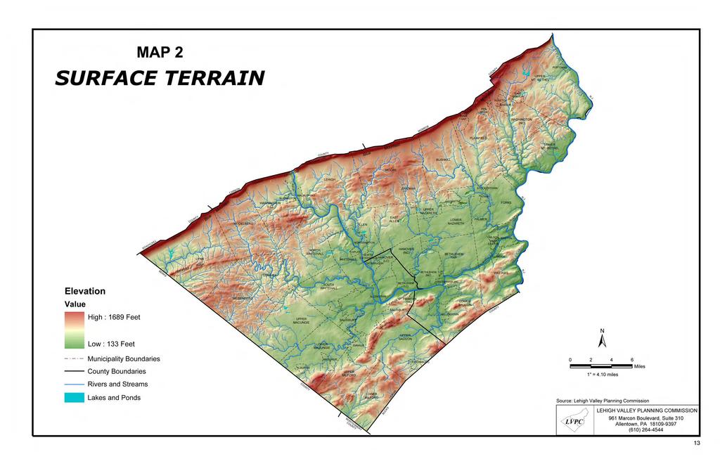
1 NATURAL RESOURCES PLAN This plan begins with an evaluation of important natural resources in the Lehigh Valley and what should be done to protect them. Before a plan for development is proposed it is first necessary to determine what needs to be preserved. Voters have spoken very clearly on the subject in public opinion surveys conducted over the past 30 years. They want to preserve important natural resources. Map 2 shows surface terrain features and streams in the 730 square mile Lehigh Valley area. The Lehigh River flows through Lehigh Gap at the northern boundary of Lehigh and Northampton counties southbound to Allentown where it makes an abrupt turn eastward. From Allentown the Lehigh flows eastward to its confluence with the Delaware River at Easton. Major tributary streams flowing into the Lehigh River are Jordan Creek, Little Lehigh Creek, Hokendauqua Creek, Monocacy Creek and Saucon Creek. Bushkill Creek and Martins Creek flow directly into the Delaware. Blue Mountain, otherwise known as Kittatiny Ridge, extends southwest to the Maryland border. The mountain forms the northern boundary of Lehigh and Northampton counties. Lehigh Mountain and South Mountain are two landmark ridges on the southern border of Allentown. They are parts of a section of mountains called the Reading Prong which extend south of Emmaus, Macungie and Alburtis into Berks County. The eastward extension of these mountains extend through southern Northampton County and then northeast to Massachusetts. Between Blue Mountain and South Mountain is a seven mile wide limestone valley where most people in the Lehigh Valley live and work. To the north of this valley is a low shale plateau with undulating hills, stream headwaters and a rural environment. The variety of topographic features in the Lehigh Valley creates a landscape with many natural landmarks and scenic beauty. RIVERS AND STREAMS The rivers and streams of the Lehigh Valley have played an important role in its history and development. The area s three cities and some of its major boroughs grew along the banks of the Lehigh or Delaware rivers. The Lehigh and Delaware Navigation Canals owed their existence to these rivers. Many streams served as the sites for early mills that were dependent on a supply of running water. Most major industries also were located along the banks of rivers or streams. Visually, rivers and streams provide some of the most scenic settings in the region. The top example of this is the Delaware River Scenic Drive that follows Route 611. The multitude of recreation activities associated with waterways is high on the list of important regional assets. The Lehigh and Delaware are large enough to provide boating opportunities, including some fine canoeing and good fishing. The Forks of the Delaware Shad Fishing Tournament and Festival, held in late April each year in Easton, is a locally important event that depends on the yearly shad migration up the Delaware River. Some of the best trout fishing in eastern Pennsylvania can be found in the Little Lehigh Creek, Monocacy Creek and Bushkill Creek. Many of the Lehigh Valley s best walking and biking trails are located near rivers and streams. The D & L Trail, a 150-mile path for hikers and bikers, extends from Bristol Borough in lower Bucks County to Wilkes-Barre. Through much of our region the D & L Trail follows the towpaths of the Delaware and Lehigh Navigation Canals. From the Village of Cementon north it will use the right-of-way of the abandoned railroad that parallels the western side of the Lehigh River. Municipal parkways have been developed along rivers and streams. The most notable is the Little Lehigh Parkway in Allentown. This splendid, fourmile long greenway extends from the western edge of the city nearly to the Lehigh River. It contains a variety of trails, a fish hatchery and roadway. Other noteworthy parks include Trexler-Lehigh County Game Preserve, Jordan Creek Parkway, Cedar Creek Parkway East and West, Monocacy Nature Center, Saucon Park, Jacobsburg Environmental Education Center, Hugh Moore Historical Park, and Delaware Canal State Park. A number of munici-palities have developed parks adjacent to the Delaware and Lehigh Navigation Canals. 11
2 Rivers and streams either serve, or have the potential to serve, as linkages between recreation areas. The most notable linkage is the one at the Lehigh Water Gap where the Appalachian Trail crosses the D & L Trail. Other linkages have been created by rail-trail projects in places such as Whitehall Township, Bethlehem Township and Palmer Township. Critical wildlife habitats are found along waterways in the Lehigh Valley. Many species of birds, aquatic animals and mammals depend on river and stream corridors for travel, cover and nesting places. The report A Natural Areas Inventory of Lehigh and Northampton Counties, Pennsylvania lists the Delaware River as one of two Exceptional Natural Features in the region. The other is the Blue Mountain. According to the natural areas inventory the Delaware River and its adjacent forested watersheds comprise one of the major corridors for the movement of biota in eastern Pennsylvania. Finally, high quality rivers and streams are of critical importance for the preservation of water supplies in the Lehigh Valley. Much of the water we use comes directly or indirectly from local waterways. STREAM QUALITY DESIGNATIONS The streams of the state have been given water quality ratings by the Pennsylvania Department of Environmental Protection (DEP). These DEP stream quality designations are listed below. EV (Exceptional Value Waters) waters that constitute an outstanding national, state, regional or local resource, such as waters of national, state or county parks or forests, or waters that are used as a source of unfiltered potable water supply, or waters that have been characterized by the Fish Commission as Wilderness Trout Streams, and other waters of substantial recreational or ecological significance. HQ (High Quality Waters) a stream or watershed with exceptional quality waters and environmental features that require special protection. CWF (Cold Water Fishes) maintenance and/ or propagation of fish species and flora and fauna that are native to cold water habitats. TSF (Trout Stocking) maintenance of stocked trout from February 15 to July 31 and maintenance and propagation of fish species and flora and fauna which are native to warm water habitats. MF (Migratory Fishes) passage, maintenance and propagation of fishes which ascend to flowing waters to complete their life cycle. WWF (Warm Water Fishes) maintenance and propagation of fish species and flora and fauna that are native to warm water habitats. Map 3 shows the stream quality designations and the number of miles in each category in the Lehigh Valley. Exceptional Value streams include parts of the Maiden Creek headwaters in Lynn Township, a small partion of the Bushkill Creek in Bushkill Township, a section of Slateford Creek in Upper Mt. Bethel Township and a tributary of Cooks Creek in Lower Saucon Towship. A number of streams qualify as High Quality Waters-Cold Water Fishes. These include important local streams such as the Little Lehigh, Cedar, Monocacy and Bushkill. Several tributaries to Jordan Creek are rated as High Quality Waters-Cold Water Fishes, Migratory Fishes. RIPARIAN BUFFERS Riparian buffers are recognized as a vital feature for protecting and reclaiming waterways. A riparian buffer is an area of vegetation that is maintained along the shore of a water body to protect stream water quality and stabilize stream channels and banks. The riparian buffer reduces the amount of runoff pollutants entering the stream. It also controls erosion, provides leaf-litter to the stream and habitat for many desirable species of amphibians, reptiles, mammals and birds. If wide enough, riparian buffers function as corridors for migrating large and small mammals. The riparian vegetation affects the stream channel shape and structure, as well as the stream s canopy cover, shading, nutrient inputs and amount of large woody debris entering the stream. Riparian canopy cover (branches and tree crowns overhanging a stream) is important not only for its role in moderating stream temperatures through shading, but also as an indicator of conditions that control bank stability, and as an energy source from leaves that will fall into the water. Aquatic macroinvertebrate organisms such as stoneflies eat, shred and break the leaves into coarse and fine particulate organic material that becomes food for other stream organisms. 12
3
4
5 MAP 3 STREAM QUALITY MONROE *Designated or Existing Use: Exceptional Value Waters High Quality Cold Water Fishes Cold Water Fishes Trout Stocking Fishes Warm Water Fishes CARBON Watershed Boundary Municipal Boundary County Boundary SCHUYLKILL Lake or Pond 5 LYNN HEIDELBERG MOORE PORTLAND MT. BETHEL PLAINFIELD BUSHKILL BERKS WEISENBERG WASHINGTON LOWHILL SLATINGTON 2 4 WALNUTPORT 3 NORTH 4 SOUTH 8 ALLEN COPLAY EAST ALLEN NORTH CATASAUQUA HANOVER CATASAUQUA 11 ALLENTOWN CHAPMAN BATH HANOVER 10 FOUNTAIN HILL 15 1 SALISBURY 1 SALISBURY SAUCON EMMAUS ALBURTIS COOPERSBURG MILFORD 6 MT. BETHEL TWP. PALMER FORKS WILLIAMS SAUCON BUCKS MILFORD EAST BANGOR ROSETO 13 PEN ARGYL BANGOR WIND GAP WASHINGTON 12 9 FREEMANSBURG STOCKERTOWN TATAMY WILSON WEST EASTON GLENDON 14 EASTON Watersheds 1 Little Lehigh Creek 2 Jordan Creek 3 Coplay Creek 4 Trout/Bertsch Creeks 5 Maiden Creek Headwaters 6 Perkiomen Creek Headwaters 7 Saucon Creek 8 Hokendauqua Creek 9 Nancy Run 10 Monocacy Creek 11 Catasauqua Creek and Adjacent Watersheds 12 Bushkill Creek 13 Martins/Jacoby Creeks 14 Fry's Run and Adjacent Watersheds 15 Saucony Creek Headwaters 16 Tohickon Creek/Delaware River (North) HELLERTOWN Miles Source: Lehigh Valley Planning Commission; PennDOT, 1997; PA Dept. of Environmental Protection, PA Code, Title 25, Chapter 93, Water Quality Standards-Drainage Lists and Existing Use Lists MONTGOMERY *NOTE: This map was updated in April 2007 to include stream segments that DEP has classified with an Existing Use that is higher than the Designated Use. DEP will regulate to the higher use. LVPC VALLEY PLANNING COMMISSION 961 Marcon Boulevard, Suite 310 Allentown, PA (610)
Lehigh Valley Trails Inventory 2013 Lehigh and Northampton Counties
 Lehigh Valley Trails Inventory 2013 Lehigh and Northampton Counties Lehigh Valley Planning Commission May 2013 i ii This page left intentionally blank. Lehigh Valley Trails Inventory 2013 Lehigh and Northampton
Environmental Review and Permitting for Wild Trout
 Environmental Review and Permitting for Wild Trout Tom Shervinskie Wild Trout Summit Watershed Analysis Section August 26, 2017 Division of Environmental Services The mission of the Pennsylvania Fish and
# Tax Parcel ID Address Owner Acreage Zoning Land Use Description Mountain Drive North, LP
 SECTION C # Tax Parcel ID Address Owner Acreage Zoning Land Use Description 1 Q6NW2 7 2 0719 1425 Mountain Dr. N 1425 Mountain Drive North, LP 1.52 GB2 Commercial Lehigh Gas 2 Q6NW2 7 16 0719 2225 Kohler
Dams are. Failure of. population). 101 dams in pose little. There are. dam. Size Category. Height (Acre feet) Dam. Category.
. 101 dams in pose little. There are. dam. Size Category. Height (Acre feet) Dam. Category.") 4.3.144 Dam Failure Dams are manmade structures designed to serve a varietyy of uses, ncluding; water supply, power generation, creation of recreational areas, and flood protection. They are made of concrete,
4.3.144 Dam Failure Dams are manmade structures designed to serve a varietyy of uses, ncluding; water supply, power generation, creation of recreational areas, and flood protection. They are made of concrete,
WALK LV WALK LEHIGH VALLEY REGIONAL SIDEWALK INVENTORY
 WALK LV WALK LEHIGH VALLEY REGIONAL SIDEWALK INVENTORY JUNE 27, 2016 INTRODUCTION This sidewalk inventory is the first of its kind for the Lehigh Valley region and intends to provide an assessment of
Dams are. Failure of. population). these B-1. C-1. tributary of the. Tumble Brook. is permitted. Classification: B-1.
. these B-1. C-1. tributary of the. Tumble Brook. is permitted. Classification: B-1.") 4.3.144 Dam Failure Dams are manmade structures designed to serve a varietyy of uses, ncluding; water supply, power generation, creation of recreational areas, and flood protection. They are made of concrete,
4.3.144 Dam Failure Dams are manmade structures designed to serve a varietyy of uses, ncluding; water supply, power generation, creation of recreational areas, and flood protection. They are made of concrete,
 Time of Change We Are Growing We Are An Attractive Place To Live We Are Age Diverse + Living Longer 50000 40000 30000 20000 10000 0 2010 Census Job Density Housing Sheds Transit Sheds The Project FUNDING
Coldwater Heritage Partnership
 Coldwater Heritage Partnership To provide leadership, coordination, technical assistance, and funding support for the conservation and protection Pennsylvania s coldwater streams and wild trout populations.
Columbia Lake Dam Removal Project
 Columbia Lake Dam Removal Project The Columbia Lake dam located 1/4 mile upstream of the Paulins Kill River's confluence with the Delaware River in Knowlton Township, Warren County has been proposed for
COLUMBIA LAKE DAM REMOVAL PROJECT
 COLUMBIA LAKE DAM REMOVAL PROJECT Major Goals of the Columbia Lake Dam Removal: Reconnect 10 miles of the Paulins Kill River to the Delaware River, restoring natural flow regime and sediment transport.
Columbia Lake Dam Removal Project
 Columbia Lake Dam Removal Project Major Goals of the Columbia Lake Dam Removal: Reconnect 10 miles of the Paulins Kill River to the Delaware River, restoring natural flow regime and sediment transport.
Searsville Dam Removal
 Searsville Dam Removal A unique opportunity for all Presented by the Beyond Searsville Dam Coalition San Francisquito Creek flows into the San Francisco Bay near the Palo Alto Airport and Golf Course seen
Broken Bar W Ranch TETON VALLEY, IDAHO. Hunting Ranching Fly Fishing Conservation
 Broken Bar W Ranch TETON VALLEY, IDAHO Hunting Ranching Fly Fishing Conservation Broken Bar W Ranch TETON VALLEY, IDAHO Introduction: The Broken Bar W Ranch is located in Driggs, Idaho, the county seat
Quiet Water New Jersey And Eastern Pennsylvania: AMC's Canoe And Kayak Guide To The Best Ponds, Lakes, And Easy Rivers (AMC Quiet Water Series) By
 By") Quiet Water New Jersey And Eastern Pennsylvania: AMC's Canoe And Kayak Guide To The Best Ponds, Lakes, And Easy Rivers (AMC Quiet By Kathy Kenley List,of,University,of,Pennsylvania,people,.,the,W.,P.,Carey,School,of,Busine
Quiet Water New Jersey And Eastern Pennsylvania: AMC's Canoe And Kayak Guide To The Best Ponds, Lakes, And Easy Rivers (AMC Quiet By Kathy Kenley List,of,University,of,Pennsylvania,people,.,the,W.,P.,Carey,School,of,Busine
Trout Unlimited and the Kittatinny Ridge Coalition.
 Trout Unlimited and the Kittatinny Ridge Coalition www.tu.org Trout Unlimited TU works to protect, reconnect, restore and sustain North America s coldwater fisheries and their watersheds. We use science
Western Pocono Chapter. Trout Unlimited. 67 West Butler Drive fc ^
 February 18,2013 Rosemary Chiavetta, Esq. Secretary Western Pocono Chapter Trout Unlimited 67 West Butler Drive fc Drums, PA 18222 3 m "TJ {"H > ro -< c? O Pennsylvania Public Utility Commission P.O.
Water Quality Standards Class A Stream Redesignations
 Water Quality Standards Class A Stream Redesignations 25 Pa. Code Chapter 93 46 Pa.B. 1205 (March 5, 2016) Environmental Quality Board Regulation #7-528 (Independent Regulatory Review Commission #3140)
INDIANA REGIONAL GENERAL CONDITIONS FOR THE STATE OF INDIANA
 INDIANA REGIONAL GENERAL CONDITIONS FOR THE STATE OF INDIANA These regional conditions are in addition to but do not supersede the requirements in the Federal Register (Volume 82 No. 4 of January 6, 2017).
P.O. Box 65 Hancock, Michigan USA fax
 This PDF file is a digital version of a chapter in the 2005 GWS Conference Proceedings. Please cite as follows: Harmon, David, ed. 2006. People, Places, and Parks: Proceedings of the 2005 George Wright
SAUCON RAIL TRAIL SPECIAL EVENT REGISTRATION FORM
 SAUCON RAIL TRAIL SPECIAL EVENT REGISTRATION FORM General All organized events on the Saucon Rail Trail (SRT) require the approval of the Saucon Rail Trail Oversight Commission. Completion of this registration
FINAL REPORT. Yonkers Creek Migration Barrier Removal Project Wonderstump Road Del Norte County. Submitted By:
 FINAL REPORT Yonkers Creek Migration Barrier Removal Project Wonderstump Road Del Norte County Submitted By: Del Norte County Community Development Department Yonkers Creek Migration Barrier Removal Project
Executive Summary. Map 1. The Santa Clara River watershed with topography.
 Santa Clara River Steelhead Trout: Assessment and Recovery Opportunities December 2005 Prepared By: Matt Stoecker and Elise Kelley, Ph.D. University of California, Santa Barbara Prepared For: The Santa
Wisconsin s Citizen-Based Monitoring Partnership Program and Trout Unlimited Driftless Area Restoration Effort (TUDARE)
") Wisconsin s 2010-11 Citizen-Based Monitoring Partnership Program and Trout Unlimited Driftless Area Restoration Effort (TUDARE) TUDARE Stream Monitoring Sites Established in 2010-2011 Summary Prepared
Wisconsin s 2010-11 Citizen-Based Monitoring Partnership Program and Trout Unlimited Driftless Area Restoration Effort (TUDARE) TUDARE Stream Monitoring Sites Established in 2010-2011 Summary Prepared
Trout Unlimited Comments on the Scope of Environmental Impact Statement for the Constitution Pipeline Project, Docket No. PF12-9
 October 9, 2012 Kimberly D. Bose, Secretary Federal Energy Regulatory Commission 888 First Street, NE, Room 1A Washington, DC 20426 RE: Trout Unlimited Comments on the Scope of Environmental Impact Statement
1.Mill Creek Watershed Summary Description and Land Use
 1.Mill Creek Watershed Summary Description and Land Use Table xxx: Mill Creek Watershed Overview Watershed Size 31,435 acres/49.1 sq miles/ 127.1 sq km Elevation Range 5,594 feet [4,967-10,561] Stream
Distribution. PFBC Northcentral Region Law Enforcement Office, Attention: WCO Kraynak, 1150 Spring Creek Road, Bellefonte, PA 16823
 Distribution Pennsylvania Department of Environmental Protection, Northcentral Region Office, Attention: Steve Means, 208 West Third St. Suite 101, Williamsport, PA 17701 PFBC Northcentral Region Law Enforcement
Wild Virginia and Heartwood first raised this issue at the May 19, 2014 public meeting.
 June 13, 2014 Karen Stevens Pat Sheridan, District Ranger Warm Springs Ranger District 422 Forestry Road Hot Springs, VA 24445 karenlstevens@fs.fed.us psheridan@fs.fed.us re: Lower Cowpasture Restoration
APPENDIX A COUNTY-LEVEL HOUSING CHARACTERISTICS IN 2000
 APPENDIX A COUNTY-LEVEL HOUSING CHARACTERISTICS IN 2000 Overview There are 67 counties in Pennsylvania, some of which are urban and others rural. Pennsylvania is home to the major cities of Philadelphia
Overview Open Space and Recreation
 Overview Open Space and Recreation Open Space Plan (2004) Environmental Priority Areas Town Character Priority Areas Recreational Facilities maintained by the Town RSU 21 Recreational Facilities in Kennebunk
Monthly Indicators - 5.7% - 6.3% - 2.6% Activity Overview New Listings Pending Sales. Closed Sales. Days on Market Until Sale. Median Sales Price
 Monthly Indicators 2019 Despite a strong U.S. economy, historically low unemployment and steady wage growth, home sales began to slow across the nation late last year. Blame was given to a combination
Table VI-Proj SITE-SPECIFIC MANAGEMENT MEASURES FOR THE ROOT RIVER WATERSHED
 00216268.DOC 300-1104 MGH/JEB/pk 01/31/14, 02/04/14 Table VI-Proj SITE-SPECIFIC MANAGEMENT MEASURES FOR THE ROOT RIVER WATERSHED LRC-01 Habitat Hoods Creek entire length Village of Mt. Various Reiterate
The Calawah River System
 The Calawah River System The Calawah River is the largest tributary of the Bogachiel River and is formed by the confluence of the north and south forks of the Calawah. The two forks of the Calawah, CALAWAH
Chapter 5 Future Transportation
 Chapter 5 Future Transportation The Future Land Use Plan identifies the desired land use designations. The land uses desired for Crozet depend, in large part, on the success of the transportation system,
Allegheny Parker. Credit: Timothy Wertz, PFBC
 Pennsylvania Fish & Boat Commission 2012 Annual Summary Allegheny River @ Parker. Credit: Timothy Wertz, PFBC In this issue. Pennsylvania s Wildlife Action Plan Mussels of the Susquehanna River Fishes
Community Open House December 13, A project of the Green Infrastructure Center, supported by Skeo Solutions
 Community Open House December 13, 2011 A project of the Green Infrastructure Center, supported by Skeo Solutions Project Background The Green Infrastructure Center, Inc. (GIC) was formed in 2006 to help
8 Bicycle and Pedestrian Facilities
 8 Bicycle and Pedestrian Facilities 8.1 Existing Facilities The facilities available to walkers and bikers are diverse in the rural ACOG area. Walking and biking are, by their nature, localized modes of
TxDOT Bicycle Tourism Trails Study Update. April 2017 BAC Meeting April 10, 2017
 AGENDA ITEM 6 TxDOT Bicycle Tourism Trails Study Update April 2017 BAC Meeting April 10, 2017 Agenda Approval of interim products o Present study vision statement, goals, and study objectives o Present
The Cove Run Brook Trout Restoration Project with the Northern Garrett High School AP Environmental Science Class,
 The Cove Run Brook Trout Restoration Project with the Northern Garrett High School AP Environmental Science Class, 2012 2014. Image or Graphic Presented By: Alan W. Klotz, Western Region District I, Inland
Example Applications
 Example Applications The following example applications are intended to present how the tools developed for Trout Unlimited s Brook Trout Conservation Portfolio and Range-wide Assessment of Habitat Condition
RLRC COMMUNITIES EAST GRAND FORKS AREA CHARACTER THE RED LAKE RIVER & THE RED RIVER OF THE NORTH CONFLUENCE EAGLE POINT BOAT LAUNCH DESIGN
 AREA CHARACTER THE RED LAKE RIVER & THE RED RIVER OF THE NORTH CONFLUENCE EAGLE POINT BOAT LAUNCH DESIGN DESIGN DETAILS 135 AREA CHARACTER East Grand Forks a city of 7,501 people is located across the
STEELHEAD SURVEYS IN OMAK CREEK
 STEELHEAD SURVEYS IN OMAK CREEK 2002 Annual Report Prepared by Chris Fisher John Arterburn Colville Confederated Tribes Fish and Wildlife Department P.O. Box 150 Nespelem, WA 99155 Prepared for Project
Susquehanna University and the PFBC Unassessed Waters Initiative in the Susquehanna Basin Jonathan M. Niles Mike Bilger
 and the PFBC Unassessed Waters Initiative in the Susquehanna Basin 2011-2015 Jonathan M. Niles Mike Bilger Pennsylvania Streams All streams of PA have a designated use - Huge resource - 8,011 named tributaries:
Newsletter Spring 2014
 Newsletter Spring 2014 Something s Fishy Here Free migration for fish is crucial to achieve healthy fish populations and ecosystems. While most fish are migratory to some degree, some species like salmon,
DRAFT MEMORANDUM TO FILE
 FROM: SUBJECT: DRAFT MEMORANDUM TO FILE Unique Stream Segment Committee File [NTD02182] T:\Task 8 - Unique Designations and Regulatory Issues\Draft Committee Memo.doc Summary of Regional Water Planning
CHAPTER 4 DESIRED OUTCOMES: VISION, GOALS, AND OBJECTIVES
 CHAPTER 4 DESIRED OUTCOMES: VISION, GOALS, AND OBJECTIVES Vision One of the first steps in developing this Plan was articulating a vision - a clear statement of what the Plan strives to achieve and what
Klickitat County Shoreline Master Program Update. Open House March 15, 2017
 Klickitat County Shoreline Master Program Update Open House March 15, 2017 Agenda 6:00 6:10 Welcome 6:10 6:40 Presentation SMP Update Process Shoreline Analysis review 6:40 8:00 Open House Topics SMP Process
Pre-Application Document Kaweah Project (FERC Project No. 298)
") TABLE OF CONTENTS Page 3.12 Aesthetic Resources... 3.12-1 3.12.1 Information Sources... 3.12-1 3.12.2 Setting... 3.12-1 3.12.3 Project Facilities... 3.12-2 3.12.4 Previous Visual Resources Assessment...
TABLE OF CONTENTS Page 3.12 Aesthetic Resources... 3.12-1 3.12.1 Information Sources... 3.12-1 3.12.2 Setting... 3.12-1 3.12.3 Project Facilities... 3.12-2 3.12.4 Previous Visual Resources Assessment...
III BASIN DESCRIPTION
 III-1 III BASIN DESCRIPTION The Youghiogheny Basin covers 1768 sq mi and extends from northern Maryland to McKeesport, Pennsylvania. This report deals only with the 1,255 sq mi of the basin within Pennsylvania
Fitting Light Rail through Well-established Communities
 Fitting Light Rail through Well-established Communities San Francisco 2008 Michael D. Madden Chief, Project Development, Maryland Transit Administration Project Setting Located inside the Capital Beltway
Public Notice. Corps File No. LRE Date: March 19, 2017 Expires: March 18, 2022
 US Army Corps of Engineers Detroit District Public Notice Corps File No. LRE-2016-00006-100 Date: March 19, 2017 Expires: March 18, 2022 PUBLIC NOTICE ANNOUNCING REGIONAL CONDITIONS AND WATER QUALITY CERTIFICATIONS
Audubon Cooperative Sanctuary Program for Golf Courses. Place Alternating Slideshow Photo Here
 Audubon Cooperative Sanctuary Program for Golf Courses Place Alternating Slideshow Photo Here Audubon Cooperative Sanctuary Program for Golf Courses In 1991, Audubon International, with the support of
Holderness. The Three Watersheds within the Newfound Lake Drainage Dorchester. Groton Plymouth. Ashland. Hebron. Canaan. Bridgewater.
 Background Brook trout are the only native stream dwelling trout species in New Hampshire, having a historic range that extended from Georgia to eastern Canada. It is believed that wild brook trout were
Notice. Proposed Changes to List of Class A Wild Trout Waters September 2017
 Notice Proposed Changes to List of Class A Wild Waters September 2017 The Fish and Boat Commission (Commission) is considering changes to its list of Class A Wild Streams. Under 58 Pa. Code 57.8a (relating
What is a River Basin Restoration Priority? 1. Criteria for Selecting a Targeted Local Watershed (TLW) 2. Hiwassee River Basin Overview 3
 2. Hiwassee River Basin Overview 3") Hiwassee River Basin Restoration Priorities 2008 TABLE OF CONTENTS Introduction 1 What is a River Basin Restoration Priority? 1 Criteria for Selecting a Targeted Local Watershed (TLW) 2 Hiwassee River
Hiwassee River Basin Restoration Priorities 2008 TABLE OF CONTENTS Introduction 1 What is a River Basin Restoration Priority? 1 Criteria for Selecting a Targeted Local Watershed (TLW) 2 Hiwassee River
Importance of un-named tributary streams to Brook Trout populations. Dr. Jonathan M. Niles Dr. Dan Ressler
 Importance of un-named tributary streams to Brook Trout populations. Dr. Jonathan M. Niles Dr. Dan Ressler Pennsylvania Streams All streams of PA have a designated use - Huge resource - 8,011 named tributaries:
10 is bounded by wetlands between RM 1.8 and 3.1 on the south shore and more are scattered
 The Ozette System The Ozette watershed is made up of several lakes and large streams that combine to a total drainage area of 88.4 square miles. The most significant feature of the Ozette watershed is
COMMONWEALTH OF PENNSYLVANIA ENVIRONMENTAL QUALITY BOARD PETITION FORM
 0120 FM PY0004 Rev. 3/2003 COMMONWEALTH OF PENNSYLVANIA ENVIRONMENTAL QUALITY BOARD PETITION FORM I. PETITIONER INFORMATION Name: Brodhead Watershed Association, Tobyhanna Creek Tunkhannock Creek Watershed
Current Wild Trout Classification Overview and Listing Process
 Current Wild Trout Classification Overview and Listing Process Pennsylvania Wild Trout Summit David Nihart - PFBC August 26, 2017 Wild Trout Programs Wild Trout Waters (Natural Reproduction) Class A Wild
Big Spring Creek Habitat Enhancement and Fishery Management Plans
 Big Spring Creek Habitat Enhancement and Fishery Management Plans November 5, 2012 Big Spring Events and Activities Center Newville, PA Charlie McGarrell Regional Habitat Biologist Pennsylvania Fish and
Mill Creek/Rose Valley Watershed General Information Presented by Dr. Mel Zimmerman Lycoming College CWI
 Mill Creek/Rose Valley Watershed General Information Watershed Concerns Rose Valley Lake Areas of Interest Biodiversity of Interest in Rose Valley Lake Rose Valley Lake Bird Area Fishes of Rose Valley
State of the Water. October 25, 2016 Union County Community Center
 State of the Water October 25, 2016 Union County Community Center What is a Watershed? Nashville Birmingham Atlanta Athens Etowah Cleveland Murphy Andrews Hayesville Copper Hill Blue Ridge Young Harris
DOWNLOAD OR READ : THE DELAWARE RIVER WATER WAR PDF EBOOK EPUB MOBI
 DOWNLOAD OR READ : THE DELAWARE RIVER WATER WAR PDF EBOOK EPUB MOBI Page 1 Page 2 the delaware river water war the delaware river water pdf the delaware river water war The Delaware River is a major river
Part 9 Specific Land Uses - Foreshore & Waterway Development
 7 FORESHORE AND WATERWAY DEVELOPMENT This section applies to the following development uses proposed within the foreshore area (defined by LM LEP 2014), and contains Council s specific requirements for
Designated Trout Stream Additions Arrowhead Creek
 Designated Trout Stream Additions Arrowhead Creek A small reach of Arrowhead Creek was inadvertently left off the list of sections when the stream was originally designated. This designation would fill
STREAM SURVEY File form No..
 scanned for KRIS THE RESOURCES AGENCY OF CALIFORNIA California Department of Fish and Game STREAM SURVEY File form No.. Date: September 4, 1969. NAME: North Fork Schooner Gulch Creek COUNTY: Mendocino.
Lower Saluda Scenic River Advisory Council
 Saluda Hydro Project, FERC Project No. 516: Comments on ICD Page 1 of 10 Lower Saluda Scenic River Advisory Council c/o South Carolina Department of Natural Resources 1000 Assembly Street, Suite 354, Columbia,
Resources and Guidance for writing a River Herring Management Plan
 Resources and Guidance for writing a River Herring Management Plan In 2011 members of the River Herring Network brainstormed a list of questions that should be answered in order to develop a plan for herring
Eastern Brook Trout Joint Venture Completed Project Report Form
 Eastern Brook Trout Joint Venture Completed Project Report Form Project Title: Assessing the Efficacy of Remediating Episodic Low ph (and High Aluminum) Concentrations in Headwater Brook Trout Streams
Chagrin River TMDL Appendices. Appendix F
 Appendix F The following are excerpts from the Eastern Brook Trout Joint Venture s Conservation Strategy (Working Draft v.6), Conserving the Eastern Brook Trout: Strategies for Action Found at: http://www.easternbrooktrout.org/constrategy.html
Kasaan to Goose Creek Road Project Project Description U.S. Army Corps of Engineers Permit The following table presents the mile point of the culverte
 Kasaan to Goose Creek Road Project Project Description U.S. Army Corps of Engineers Permit The following table presents the mile point of the culverted open water crossings, name of water crossing if known,
FAYETTE COUNTY. Fayette County Active Transportation Profile REGIONAL ACTIVE TRANSPORTATION PLAN FOR SOUTHWESTERN PENNSYLVANIA
 REGIONAL ACTIVE TRANSPORTATION PLAN FOR SOUTHWESTERN PENNSYLVANIA 1 2 ACTIVE TRANSPORTATION AT A GLANCE Trails + Bike Routes 4 miles 73 miles 130 miles 90 miles Parkland Parkland Trail Off Street Trail
3.9 Recreational Trails and Natural Areas
 3.9 Recreational Trails and Natural Areas 3.9.1 Introduction Parks and other recreational facilities such as trails, bicycle routes, and open space are important community resources. This section discusses
Transportation Alternatives Set-Aside Program. June 28, 2017
 Transportation Alternatives Set-Aside Program June 28, 2017 What is Transportation Alternatives Set- Aside Program (TASA)? Enhancement program (combined separated programs; old TAP) Not a grant program
FACT SHEET MCGREGOR LAKE RESTORATION HABITAT PROJECT POOL 10, UPPER MISSISSIPPI RIVER, WISCONSIN ENVIRONMENTAL MANAGEMENT PROGRAM
 FACT SHEET MCGREGOR LAKE RESTORATION HABITAT PROJECT POOL 10, UPPER MISSISSIPPI RIVER, WISCONSIN ENVIRONMENTAL MANAGEMENT PROGRAM LOCATION McGregor Lake is located within a mid-river island in Pool 10
Trout Buffer Variance
 Trout Buffer Variance Ashley L. Rodgers, PE Spring 2015 Why a Trout Buffer Capturing pollutants in runoff to keep the water clean. Capturing sediment to keep mud out of the water. Providing shade to keep
Quassaick Creek. Watershed Management Plan. Advisory Committee Meeting #3 July 20 th, 2012
 Quassaick Creek Watershed Management Plan Advisory Committee Meeting #3 July 20 th, 2012 Assessment Report Subwatershed Delineation Characterizes watershed based on Hydrology/Topography (primary) Land
Sebec Lake Fisheries Management Plan 2012
 Sebec Lake Fisheries Management Plan 2012 Sebec Lake is a 6,800-acre oligotrophic lake located in northwestern Maine. It has popular fisheries for landlocked salmon, lake trout, and smallmouth bass. Other
Wildlife Introduction
 Wildlife Introduction The wildlife section of this chapter is divided into sections for various habitats and groups of species. Old growth, snags and downed wood, and riparian areas are unique habitats
RULES AND REGULATIONS Title 25 ENVIRONMENTAL PROTECTION
 RULES AND REGULATIONS Title 25 ENVIRONMENTAL PROTECTION ENVIRONMENTAL QUALITY BOARD [ 25 PA. CODE CH. 93 ] Water Quality Standards; Class A Stream Redesignations The Environmental Quality Board (Board)
Biddy. February 22 8:08 AM
 Biddy 2 Northwestern (30) 1 Hokey (28) 2 Northwestern (44) 2/14 Northwestern HS 6:30pm 15 South Parkland B (11) 2/17 Whitehall HS 12:30pm 1 Hokey (25) 2 Northwestern (23) 2/16 Northwest MS 9:00am 8 Saucon
Bicycle and Pedestrian Facilities Toolbox (Excerpt from Figure 3.1)
") Appendix B Neighborhood Connections Summaries This Appendix is a supplement to the information presented in Chapter 3 Connect People. The Appendix includes a summary or profile for each of the proposed
Appendix B Neighborhood Connections Summaries This Appendix is a supplement to the information presented in Chapter 3 Connect People. The Appendix includes a summary or profile for each of the proposed
DALE HOLLOW LAKE TROOPER ISLAND IMPROVEMENT PROJECT Proposal for Reservoir Fisheries Habitat Partnership (RFHP)
") DALE HOLLOW LAKE TROOPER ISLAND IMPROVEMENT PROJECT Proposal for Reservoir Fisheries Habitat Partnership (RFHP) A. Applicant Information: US Army Corps of Engineers, Dale Hollow Lake POC: Gregg Nivens
DALE HOLLOW LAKE TROOPER ISLAND IMPROVEMENT PROJECT Proposal for Reservoir Fisheries Habitat Partnership (RFHP) A. Applicant Information: US Army Corps of Engineers, Dale Hollow Lake POC: Gregg Nivens
Muskegon River Management Plan
 Muskegon River Management Plan River Management Plan 04, February, 2003 Richard P. O Neal Introduction This Plan is a companion document to the Muskegon River Watershed Assessment (O Neal 1997). The river
Illinois Lake Management Association Conference March 23, 2018 By Trent Thomas Illinois Department of Natural Resources Division of Fisheries
 Illinois Lake Management Association Conference March 23, 2018 By Trent Thomas Illinois Department of Natural Resources Division of Fisheries Sources of Habitat Impairment Sedimentation Channelization
Walking the Walk in Montgomery County, PA
 Walking the Walk in Montgomery County, PA Walk to School Day at Myers Elementary School, Cheltenham, PA America Walks Webinar November 29, 2018 Jody Holton, AICP, Executive Director Montgomery County Planning
2.0 Existing Conditions
 20 2.0 Existing Conditions 2.1 Land Use, Future Growth Patterns, Physical Barriers Geographic Overview Sutter County s land use pattern is characterized by extensive agricultural areas, significant natural
Active Transportation Rail to River Corridor. Community Meeting - Segment A
 Active Transportation Rail to River Corridor Community Meeting - Segment A June 29, 2017 Tonight s Agenda > Open House (30 min) > Welcome / Project Overview > Presentation of 30% Design Refinements > Next
Striped Bass and White Hybrid (x) Striped Bass Management and Fishing in Pennsylvania
 Striped Bass Management and Fishing in Pennsylvania") Striped Bass and White Hybrid (x) Striped Bass Management and Fishing in Pennsylvania Prepared by R. Lorantas, D. Kristine and C. Hobbs PFBC Warmwater Unit 2005 (stocking numbers updated after 2005) Goal:
Striped Bass and White Hybrid (x) Striped Bass Management and Fishing in Pennsylvania Prepared by R. Lorantas, D. Kristine and C. Hobbs PFBC Warmwater Unit 2005 (stocking numbers updated after 2005) Goal:
MAG Town of Cave Creek Bike Study Task 6 Executive Summary and Regional Significance Report
 Page 1 MAG Town of Cave Creek Bike Study Task 6 Executive Summary and Regional Significance Report August 1, 2012 MAG Project #481 Page 2 Task 6 Executive Summary and Regional Significance Report Introduction
Table Water Withdrawal and Discharge Locations for Construction Activities Associated with the PennEast Project
 Table 3.1-1 and s for Construction Activities with the PennEast Project Use Proposed 1 2,3 4 Description of Use HUC) 7 Supplies for Dust Control Activities Residential Areas MP 14.4 40.0R2 Lake Harmony
Rahway River Fish Passage Feasibility Evaluation. Weston Solutions, Inc. February 5, 2009
 Rahway River Fish Passage Feasibility Evaluation Weston Solutions, Inc. February 5, 2009 Project Impetus Learned of the potential for fish passage on the Rahway River during meetings with the HEP and local
Mountain Valley Pipeline Project. Docket No. CP Attachment DR5 Land Use 9
 Response to Data Request Docket No. CP16-10-000 Mountain Valley Pipeline Project Docket No. CP16-10-000 Attachment DR5 Land Use 9 March 2017 DEIS TABLE 4.8.1-10 and of Visual Impacts Key Observation Points
Eastern Brook Trout. Roadmap to
 Eastern Brook Trout Roadmap to CONSERVATION Our Brook Trout heritage he wild Brook Trout is an American symbol of persistence, adaptability, and the pristine wilderness that covered North America prior
Maryland Chapter Trout Unlimited Brook Trout Conservation Effort
 Maryland Chapter Trout Unlimited Brook Trout Conservation Effort Photo by Matt Kline Portfolio of Recent Work MDTU Brook Trout Conservation Coordinator: Scott C. Scarfone, ASLA sscarfone@oasisdesigngroup.com
Table xxx: Listed and Suspected Impairments for Willow Creek 2010 Reach Impairment Pollutant Impaired Uses
 1. (Fairmont) Watershed Summary Description and Land Use Table xxx: (Fairmont) Watershed Overview Watershed Size 18,331 acres/28.7 sq miles/74.3 sq km Elevation Range 2,615 feet [4,980-7,595] Stream Miles
OVERVIEW OF MID-COLUMBIA FISHERIES ENHANCEMENT GROUP
 Mid-Columbia Fisheries Enhancement Group MISSION STATEMENT The Mid-Columbia Fisheries Enhancement Group is a non-profit organization dedicated to restoring selfsustaining salmon and steelhead populations
Feb 22, Supplemental Reclassification of Streams in the Catawba and Yadkin River Basins to Trout Waters
 Feb 22, 2010 Mr. Jeff Manning Supervisor, Classifications and Standards Unit Division of Water Quality North Carolina Department of Environment and Natural Resources 1617 Mail Service Center Re: Supplemental
Fish Community. Fish Habitat, Streams and Rivers
 Clear, Ston(e)y and White Lake Plan Fish Community The lakes support a cool/warm water fishery including muskellunge, walleye, largemouth and smallmouth bass, yellow perch, pumpkinseed, rockbass, blue
Minnesota Department of Natural Resources Division of Fish and Wildlife Section of Fisheries. Stream Survey Report. Luxemburg Creek.
 Minnesota F-29-R(P)-24 Area 315 Study 3 March 2016 Minnesota Department of Natural Resources Division of Fish and Wildlife Section of Fisheries Stream Survey Report Luxemburg Creek 2015 Mark Pelham Sauk
2012 Bring Back the Natives Awarded Projects
 2012 Bring Back the Natives Awarded Projects EZG # Organization Project Title Project Description Location Description Total Award Amount Grantee Non- Federal Match 31904 Sanctuary Forest, Inc. Mattole