Quassaick Creek. Watershed Management Plan. Advisory Committee Meeting #3 July 20 th, 2012
|
|
|
- Paula Floyd
- 5 years ago
- Views:
Transcription

1 Quassaick Creek Watershed Management Plan Advisory Committee Meeting #3 July 20 th, 2012
2 Assessment Report
3 Subwatershed Delineation Characterizes watershed based on Hydrology/Topography (primary) Land use (secondary) See Map 1

4 1. Lower Quassaick 2. Washington lake 3. Patton Brook 4. Bushfield Creek/ Middle Quassaick 5. Orange Lake 6. Chadwick Lake 7. Gidneytown Creek 8. Upper Silver Stream
5 Assessment of Waterbodies and Watershed Resources Overview Geologic Resources Water Resources Living Resources T&ES/Significant Natural Communities Pollutant & Nutrient Loading Land Use and Land Cover Community Profile Public Access
6 Watershed Overview Total Area: 56 Square miles Stream miles: miles Subwatersheds: 8 subwatersheds Subwatershed Area in Acres Bushfield Creek/Middle Quassaick Subwatershed 4,518 Chadwick Lake Subwatershed 9,084 Gidneytown Creek Subwatershed 6,299 Orange Lake Subwatershed 7,793 Patton Brook Subwatershed 1,686 Lower Quassaick Subwatershed 2,609 Washington Lake Subwatershed 645 Upper Silver Stream Subwatershed* 2,990 Grand Total 35,624

7 Brown s Pond Lake Washington
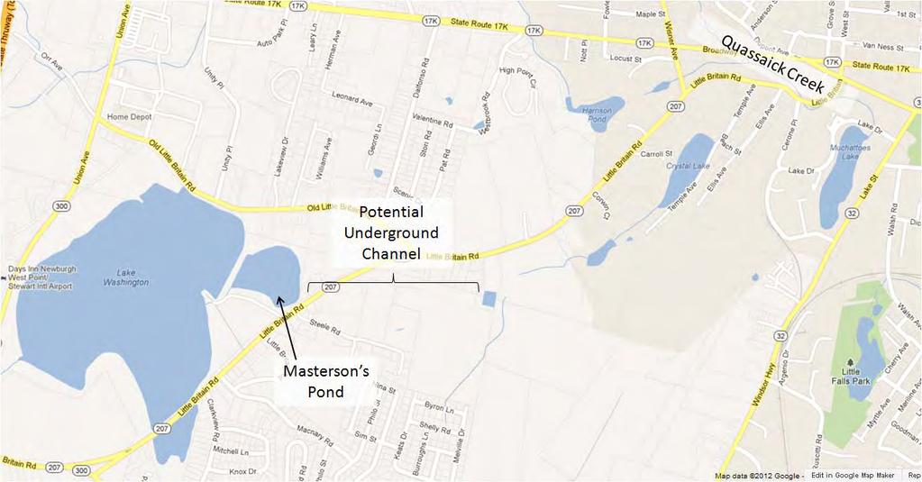
8 Lake Washington
9 Water Resources Streams: miles >1,000 lakes (10 biggest >1,000 acres) Wetlands (NWI) Subwatershed Bushfield Creek/ Middle Quassaick Estuarine and Marine Deepwater Freshwater Emergent Wetland Freshwater Forested/ Shrub Wetland Freshwater Pond Lake Riverine Other Chadwick Lake , Gidneytown Creek Lower Quassaick Orange Lake , Patton Brook Upper Silver Stream Washington Lake Grand Total (acres) , ,
10 Water Resources Floodplains (Map 4) Discuss Ulster County
11 Water Quality Priority Waterbodies List/303d List Waterbody Segment Category Causes Sources Quassaick Creek, Lower, and minor tribs ( ) Orange Lake ( ) Chadwick Lake ( ) Minor Impacts Impaired Segment No Known Impact Nutrients, Unknown Combined Sewer Overflow, Urban/Storm Toxicity Runoff Nutrients Habitat Modification, On Site/ Septic Systems, Urban/ Storm Runoff Orange Lake added to 303d List in : Sewer lines installed in 85% homes Catch basins constructed Monitor/manage geese Triploid carp stocked in 2010 (control Eurasian milfoil) TMDL not developed
12 Water Quality Biomonitoring (Map 5) Site Stream Location BAP Score _001 Quassaick Above South Plank Road bridge _002/ Quassaick City of Newburgh, 4800_0013 below American Felt & Filter Co. 4600_004 Quassaick Below Power Mill Road Bridge _005 Quassaick Above Mill Street Bridge _006 Quassaick 100m below Route 17K bridge _007 Gidneytown 100m off Route New 2012 sampling (2 NYSDEC, 5 QCWA, 5 Professionally sampled)
13 Rare Species/ Signficant Natural Communities See Map 7 Significant Communities Hemlock Northern Hardwood Forest (Chadwick) Red Maple Hardwood Swamp (Orange)
14 Rare Species/ Signficant Natural Communities Rare Species Common Name Fauna Bald eagle State Status Indiana bat E E Bog turtle E T T Federal Status Delisted; MBTA Habitat Description Migratory and nesting near large bodies of water, generally away from people Winter (Ulster only): Cave hibernacula; Summer: trees with exfoliating bark near canopy gaps Open canopy wet meadows, sedge meadows, and calcareous fens Subwatersheds with Habitat Orange Lake, Chadwick Lake, Upper Silver Stream All have potential summer roosting habitat Limited, if any Upland sandpiper T MBTA Breeding; obligate grassland species Orange Lake, Upper Silver Stream, Patton Brook Shortnose sturgeon E E Spawning N/A Hudson River Atlantic sturgeon N/L E Spawning N/A Hudson River Blueback herring N/L T(c) Migratory/ spawning Lower Quassaick Alewife N/L T(c) Migratory/ spawning Lower Quassaick Flora Woodland agrimony T N/L Rich mesic forests Gidneytown & others Small whorled pogonia N/L T Moist woods Historic record; most likely extirpated from region
15 Barriers/Impediments State ID Subwatershed Name of Barrier/Structure Waterbody Impounded Unnamed Quassaick Creek Carney Pond Dam Quassaick Creek Harrison Pond Dam Quassaick Creek Newburgh Pond #1 Dam Quassaick Creek Bushfield Creek/ Newburgh Pond #2 Dam Quassaick Creek Middle Quassaick Newburgh Pond #3 Dam Quassaick Creek Orange Lake Dams Quassaick Creek Town Hall Park Dam Quassaick Creek Winona Lake Dam Quassaick Creek Chadwick Lake Chadwick Lake Dam Quassaick Creek Groom Mill Pond Dam Quassaick Creek Brookside Pond Dam Quassaick Creek Crystal Lake Dam Quassaick Creek Tributary Lower Quassaick Harrison Dam Quassaick Creek A Holden Dam Quassaick Creek B McDole Mill Pond Dam Quassaick Creek F Strooks Felt Mill Dam Quassaick Creek Upper Silver Stream Silver Stream Reservoir Dam Silver Stream Lockwood Basin Dam Silver Stream Washington Lake Newburgh Dam Silver Stream Washington Lake Dam Silver Stream


16 Pollutant Loading Analysis Methods 1. Watershed Treatment Model Spreadsheet 2. Phosphorus 3. Subwatershed Grouping 4. Land uses categorized

17 Residential = 48% Roadways significant Commercial = 36% in Combined Potential next steps: Refine WTM? Regulate P runoff in residential areas?
18 Public Access See Map 10 Waterbody Site Name Location Type of Public Access Chadwick Lake (fed by Chadwick Lake Town of Newburgh boating, fishing, ice skating, hiking, Quassaick Creek) biking, X skiing, picnicking fed by City of Newburgh Reservoir Masterston Pond Town of New Windsor previously fishing by arrangement for senior citizens and fishing derbys Muchattoes Lake Unnamed City of Newburgh fishing* Quasssaick Creek Cronomer Hill Park Town of Newburgh hiking, biking, picnicking, sport fields, playground Bushfield Creek Algonquin Park Town of Newburgh picnicking, sport fields, playground Little Falls Pond Little Falls Park Little Falls Park fishing*, dog walking Harrison s Pond Unnamed City of Newburgh fishing* Quassaick Creek Schleiermacher City of Newburgh stream access Park Crystal Lake Unnamed City of Newburgh fishing* Miller's Pond Unnamed City of Newburgh fishing* Brown's Pond, source of Silver Stream Unnamed Town of New Windsor previously fishing by permit * informal access for fishing
19 Additional Information To Be Incorporated Photos/Call-outs Eel/herring monitoring Trees for Tribs A project that you work on! 2012 Biomonitoring 2012 Stormwater BMP Data Ulster County (floodplains?, water treatment, public access )
20 Sub-Committee Updates
21 Upcoming Activities


22 Upcoming Activities
23 Thank You Questions?
3.0 Basin and Watershed Characteristics
 3.0 Basin and Watershed Characteristics 3.1 Basin Characteristics 3.1.1 Crystal Lake Crystal Lake, located in the cities of Burnsville and Lakeville (Dakota County), covers an area of approximately 292
INDIANA REGIONAL GENERAL CONDITIONS FOR THE STATE OF INDIANA
 INDIANA REGIONAL GENERAL CONDITIONS FOR THE STATE OF INDIANA These regional conditions are in addition to but do not supersede the requirements in the Federal Register (Volume 82 No. 4 of January 6, 2017).
Vocabulary: Headwaters, watershed, tributaries, estuary, replica, point source pollution, nonpoint source pollution, amd river miles.
 From Source To Sea: Lesson Plan Concepts: 1. Understanding the path the Hudson River takes from the headwaters in the Adirondacks to the New York Harbor 2. Identifying the Hudson River watershed area,
Three point plan to addressing land use and habitat loss impacts on Chesapeake Bay tidal fish and shellfish
 Three point plan to addressing land use and habitat loss impacts on Chesapeake Bay tidal fish and shellfish 1. Establish Principles for Protection of Chesapeake Bay Fish and Shellfish The Fisheries GIT
Project Webpage:
 Project Webpage: http://nature.ly/marinesatlanticbightera Coastal Data and Full Metadata: http://easterndivision.s3.amazonaws.com/marine/sab MA/SABMACoastalEcosystems.zip Coastal Chapter: http://easterndivision.s3.amazonaws.com/marine/sab
Public Notice. Corps File No. LRE Date: March 19, 2017 Expires: March 18, 2022
 US Army Corps of Engineers Detroit District Public Notice Corps File No. LRE-2016-00006-100 Date: March 19, 2017 Expires: March 18, 2022 PUBLIC NOTICE ANNOUNCING REGIONAL CONDITIONS AND WATER QUALITY CERTIFICATIONS
VIDEO AUDIO Slide 1. Slide 2 Old timey 18 th century map of east coast
 VIDEO AUDIO Slide 1 1A Welcome to the Cooper River Rediversion Project at St. Stephen, Montage of exteriors of facility, South Carolina! Since 1985, this boating, fish runs, fishing, facility has served
Wildlife Introduction
 Wildlife Introduction The wildlife section of this chapter is divided into sections for various habitats and groups of species. Old growth, snags and downed wood, and riparian areas are unique habitats
FISH PASSAGE ON THE BRONX RIVER: A VISION OF THE BRONX RIVER ECOLOGICAL AND RESTORATION MANAGEMENT PLAN
 FISH PASSAGE ON THE BRONX RIVER: A VISION OF THE BRONX RIVER ECOLOGICAL AND RESTORATION MANAGEMENT PLAN THE SNUFF MILL DAM, BRONX ZOO DAM & 182 ND STREET DAM NEW YORK BOTANICAL GARDEN & BRONX ZOO BRONX
Klickitat County Shoreline Master Program Update. Open House March 15, 2017
 Klickitat County Shoreline Master Program Update Open House March 15, 2017 Agenda 6:00 6:10 Welcome 6:10 6:40 Presentation SMP Update Process Shoreline Analysis review 6:40 8:00 Open House Topics SMP Process
10 is bounded by wetlands between RM 1.8 and 3.1 on the south shore and more are scattered
 The Ozette System The Ozette watershed is made up of several lakes and large streams that combine to a total drainage area of 88.4 square miles. The most significant feature of the Ozette watershed is
Example Applications
 Example Applications The following example applications are intended to present how the tools developed for Trout Unlimited s Brook Trout Conservation Portfolio and Range-wide Assessment of Habitat Condition
Upper Iroquois River atershed Management Plan
 2013 Upper Iroquois River atershed Management Plan Daniel M Perkins Jasper County Soil and Water Conservation District 12/30/2013 Table of Contents 1.1 WATERSHED COMMUNITY INITIATIVE... 12 1.2 Project
Great Bay National Estuarine Research Reserve Field Notes Summer 2010 Welcome
 Great Bay National Estuarine Research Reserve Field Notes Summer 2010 Welcome Welcome to the spring edition of Field Notes, a newsletter just for our Great Bay Community Land Stewards. Spring certainly
Assessment of Baseline Geomorphic Features at. Proposed Stream Crossings On The Proposed County Road 595. Marquette County, Michigan
 Assessment of Baseline Geomorphic Features at Proposed Stream Crossings On The Proposed County Road 595 Marquette County, Michigan Prepared for: Kennecott Eagle Minerals Company Marquette, Michigan Prepared
Brook Trout in Massachusetts: A Troubled History, A Hopeful Future
 Brook Trout in Massachusetts: A Troubled History, A Hopeful Future Brook trout are one of the most beautiful and beloved fish in the Eastern United States. In Massachusetts, anglers prize opportunities
Merrimack River Watershed MERRIMACK RIVER WATERSHED
 MERRIMACK RIVER WATERSHED 96 Merrimack River Watershed Merrimack River Newburyport, Amesbury, Merrimack, Haverhill, Groveland, Methuen, Lawrence, N. Andover, Andover, Dracut, Tewksbury, Lowell, Chelmsford,
KOOTENAI RIVER BASIN WATERSHED RESTORATION PLAN
 KOOTENAI RIVER BASIN WATERSHED RESTORATION PLAN by Jeff Dunn, Watershed Hydrologist Karen Filipovich, Outreach Consultant Gary Ingman, Water Resources Scientist prepared by RESPEC 3810 Valley Commons Drive,
Overview Open Space and Recreation
 Overview Open Space and Recreation Open Space Plan (2004) Environmental Priority Areas Town Character Priority Areas Recreational Facilities maintained by the Town RSU 21 Recreational Facilities in Kennebunk
Lower Saluda Scenic River Advisory Council
 Saluda Hydro Project, FERC Project No. 516: Comments on ICD Page 1 of 10 Lower Saluda Scenic River Advisory Council c/o South Carolina Department of Natural Resources 1000 Assembly Street, Suite 354, Columbia,
Indian River Lagoon: Lessons, Challenges and Opportunities
 Indian River Lagoon: Lessons, Challenges and Opportunities Upper Chain of Lakes Lake Kissimmee Kissimmee River Indian River Lagoon Caloosahatchee Estuary Lake Okeechobee St. Lucie Estuary Mark Perry, Executive
Total Suspended Solids, Stable Flow, and Wet Weather Event Monitoring in the Unnamed Tributary to the Grand River Watershed.
 Total Suspended Solids, Stable Flow, and Wet Weather Event Monitoring in the Unnamed Tributary to the Grand River Watershed December 2004 The Cadmus Group, Inc. Grand Valley State University Annis Water
Lamprey River. Junior Ranger Study Guide and Activity Book
 Lamprey River Junior Ranger Study Guide and Activity Book Junior Ranger Lamprey River A Family-Centered Way to Learn about and Help Protect your River Created by the Lamprey Rivers Advisory Committee Copyright
1.Mill Creek Watershed Summary Description and Land Use
 1.Mill Creek Watershed Summary Description and Land Use Table xxx: Mill Creek Watershed Overview Watershed Size 31,435 acres/49.1 sq miles/ 127.1 sq km Elevation Range 5,594 feet [4,967-10,561] Stream
EXTENT OF OBSERVATION
 scanned for KRIS THE RESOURCES AGENCY OF CALIFORNIA Department of Fish and Game STREAM SURVEY Date: May 25 and 31, 1977. NAME: Unnamed Stream (Tributary to Sonoma Creek) COUNTY: Sonoma. STREAM SECTION:
West Branch Susquehanna River Annual Watershed Summit 2018
 West Branch Susquehanna River Annual Watershed Summit 2018 Kathleen Lavelle Field Coordinator Pennsylvania Coldwater Habitat Restoration Program www.tu.org Trout Unlimited Mission: To conserve, protect,
Mill Creek/Rose Valley Watershed General Information Presented by Dr. Mel Zimmerman Lycoming College CWI
 Mill Creek/Rose Valley Watershed General Information Watershed Concerns Rose Valley Lake Areas of Interest Biodiversity of Interest in Rose Valley Lake Rose Valley Lake Bird Area Fishes of Rose Valley
* On your registration, list your top three favorite choices. Register early for top choices.
 ODO-CON-17 FIELD TRIPS Important Notes: * On your registration, list your top three favorite choices. Register early for top choices. * Lists of all Odonata positively seen, photographed or collected by
RED RIVER NATIONAL WILDLIFE REFUGE
 RED RIVER NATIONAL WILDLIFE REFUGE http://www.fws.gov/refuge/red_river/ https://www.facebook.com/redrivernwr Photograph of wood ducks taken on Refuge by volunteer Ronnie Maum Wildlife Quiz 4 Bird Species
Maryland Chapter Trout Unlimited Brook Trout Conservation Effort
 Maryland Chapter Trout Unlimited Brook Trout Conservation Effort Photo by Matt Kline Portfolio of Recent Work MDTU Brook Trout Conservation Coordinator: Scott C. Scarfone, ASLA sscarfone@oasisdesigngroup.com
Water of the Rogue Valley
 Water of the Rogue Valley An Activity Book for Grades 3-5 Welcome! You are about to embark on a journey of exploration. Your adventure begins at school and continues at North Mountain Park. This workbook
Total Suspended Solids, Stable Flow, and Wet Weather Event Monitoring in the Bass River Watershed. December The Cadmus Group, Inc.
 Total Suspended Solids, Stable Flow, and Wet Weather Event Monitoring in the Bass River Watershed December 2004 The Cadmus Group, Inc. Grand Valley State University Annis Water Resources Institute Submitted
At Home on the Elbow River. -Ours to share-
 At Home on the Elbow River -Ours to share- Living in the shed You are part of the Elbow River Watershed. The Elbow River and its tributaries drain over 1,200 km² of land. The source of the Elbow River
Black Sturgeon Regional Plan
 Black Sturgeon Regional Plan This is one of twenty Regional Plans that support implementation of the Lake Superior Biodiversity Conservation Strategy (Strategy). The Strategy, prepared and overseen by
RESTORING 400 ACRES OF TIDAL MARSH IN THE SNOHOMISH RIVER DELTA
 RESTORING 400 ACRES OF TIDAL MARSH IN THE SNOHOMISH RIVER DELTA Marya Moses, Danny Moses, Neil Moses, and Robert Moses fish on Tulalip Bay, near the mouth of the Snohomish River Estuary. QWULOOLT IS A
Fish Community. Fish Habitat, Streams and Rivers
 Clear, Ston(e)y and White Lake Plan Fish Community The lakes support a cool/warm water fishery including muskellunge, walleye, largemouth and smallmouth bass, yellow perch, pumpkinseed, rockbass, blue
Claytor Lake View of the Claytor Lake dam from Claytor Lake State Park s boat ramp.
 Claytor Lake 2007 Imagine yourself on a waterbody that is more like a wide river than a lake. When you do, you will have a picture of Claytor Lake. Claytor Lake, a 4,475-acre reservoir, stretches northeastward
Clearlake Road (State Road 501) Project Development & Environment (PD&E) Study
 Project Development & Environment (PD&E) Study") Clearlake Road (State Road 501) Project Development & Environment (PD&E) Study FROM MICHIGAN AVENUE TO INDUSTRY ROAD BREVARD COUNTY, FLORIDA Financial Project ID No: 433605-1-22-01 Federal Aid Project
Clearlake Road (State Road 501) Project Development & Environment (PD&E) Study FROM MICHIGAN AVENUE TO INDUSTRY ROAD BREVARD COUNTY, FLORIDA Financial Project ID No: 433605-1-22-01 Federal Aid Project
FISHERIES MANAGEMENT PLAN FOR DUFFINS CREEK AND CARRUTHERS CREEK JUNE, 2004
 FISHERIES MANAGEMENT PLAN FOR DUFFINS CREEK AND CARRUTHERS CREEK JUNE, 2004 Toronto and Region Conservation 2004 ISBN0-9732764-0-1 www.trca.on.ca 5 Shoreham Drive, Toronto, Ontario M3N 1S4 phone: 416-661-6600
San Lorenzo Valley Water District, Watershed Management Plan, Final Version Part I: Existing Conditions Report
 LIST OF FIGURES Figure 1-1. Map of the San Lorenzo River watershed Figure 2-1. The Santa Cruz Mountains Bioregion Figure 2-2. Protected areas within the San Lorenzo River watershed Figure 2-3. Primary
Eastern Brook Trout Joint Venture Annual Report The Nature Conservancy 2013
 Eastern Brook Trout Joint Venture Annual Report The Nature Conservancy 2013 2013 Annual Performance Report Enhancing Connectivity in the Ash-Black Rock Sub-basin of the West Branch Narraguagus River. Project
Florida Seagrass Integrated Mapping and Monitoring Program
 Florida Seagrass Integrated Mapping and Monitoring Program - 2004 The following document is composed of excerpts taken from the 2011 publication, Seagrass Integrated Mapping and Monitoring for the State
Kasaan to Goose Creek Road Project Project Description U.S. Army Corps of Engineers Permit The following table presents the mile point of the culverte
 Kasaan to Goose Creek Road Project Project Description U.S. Army Corps of Engineers Permit The following table presents the mile point of the culverted open water crossings, name of water crossing if known,
Tips for Using & Printing Spreadsheets
 Key to Spreadsheets Spreadsheet # Type Description/Purpose a Development & Construction in Waterways b Debits Development & Construction in Other Aquatic Areas c Indirect Impacts to Waterways from Development
Nechako white sturgeon are an Endangered Species
 Nechako white sturgeon are an Endangered Species There are likely less than 350 Nechako white sturgeon, and historically there were over 5000 in the Nechako Watershed. Endangered as per the Species at
The Leopard Frogs of New Jersey
 NEW JERSEY DEPARTMENT OF ENVIRONMENTAL PROTECTION DIVISION OF FISH & WILDLIFE ENDANGERED & NONGAME SPECIES PROGRAM The Leopard Frogs of New Jersey Introduction to Leopard Frogs More than a dozen species
Eastern Brook Trout: Status and Threats
 david anderson Eastern Brook Trout: Status and Threats Background: Brook trout (Salvelinus fontinalis) are the only trout native to much of the eastern United States. They have inhabited the East s coldwater
Groton Open Space Association s AVERY FARM EXPLORER GUIDEBOOK
 Groton Open Space Association s AVERY FARM EXPLORER GUIDEBOOK AVERY FARM DESCRIPTION: Called one of the most biologically diverse and valuable conservation sites in eastern Connecticut, this beautiful,
III BASIN DESCRIPTION
 III-1 III BASIN DESCRIPTION The Youghiogheny Basin covers 1768 sq mi and extends from northern Maryland to McKeesport, Pennsylvania. This report deals only with the 1,255 sq mi of the basin within Pennsylvania
Rhode Island Department of Environmental Management Division of Fish and Wildlife American Shad Habitat Plan for the Pawcatuck River
 Rhode Island Department of Environmental Management Division of Fish and Wildlife American Shad Habitat Plan for the Pawcatuck River Prepared by: Phil Edwards, Rhode Island Department of Environmental
ADOPT-A-STREAM WATERSHED APPROACH COMMUNITY-BASED STEWARDSHIP. Nova Scotia Salmon Association March 2005
 ADOPT-A-STREAM A WATERSHED APPROACH TO COMMUNITY-BASED STEWARDSHIP Nova Scotia Salmon Association March 2005 This manual is a revised and updated version of the 1994 Adopt-a-Stream manual that was prepared
Outline. 1. Overview 2. Population 3. Flooding 4. Land Use 5. References. Overview
 Outline 1. Overview 2. Population 3. Flooding 4. Land Use 5. References Overview The two main rivers in the Cannon River watershed are the Cannon and Straight Rivers. The Cannon River originates in Shields
Bear Lake. Final Results Portage County Lake Study. March 31, University of Wisconsin-Stevens Point, Portage County Staff and Citizens
 Bear Lake Final Results Portage County Lake Study March 31, 2005 University of Wisconsin-Stevens Point, Portage County Staff and Citizens What can you learn from this study? You can learn a wealth of valuable
Temperature Profiling Within the Trout Creek Sub-Watershed 2013 Prepared by the Kennebecasis Watershed Restoration Committee January 2014
 Temperature Profiling Within the Trout Creek Sub-Watershed 2013 Prepared by the Kennebecasis Watershed Restoration Committee January 2014 A partnership project between the KWRC and Agriculture and Agri-Foods
Union Pacific Railroad
 Input Questions: 404/401 Pre Application Meeting, December 18, 2013, Portland, Oregon 1. What is the project purpose and need? The purpose of the project is to improve the efficiency and average velocity
MUCKLESHOOT INDIAN TRIBE Fisheries Division nd Avenue SE Auburn, Washington Phone: (253) Fax: (253)
 Fax: (253)") MUCKLESHOOT INDIAN TRIBE Fisheries Division 39015-172nd Avenue SE Auburn, Washington 98092-9763 Phone: (253) 939-3311 Fax: (253) 931-0752 U.S. Army Corps of Engineers Regulatory Branch Attn: Karen Urelius
MUCKLESHOOT INDIAN TRIBE Fisheries Division 39015-172nd Avenue SE Auburn, Washington 98092-9763 Phone: (253) 939-3311 Fax: (253) 931-0752 U.S. Army Corps of Engineers Regulatory Branch Attn: Karen Urelius
5B. Management of invasive species in the Cosumnes and Mokelumne River Basins
 5B. Management of invasive species in the Cosumnes and Mokelumne River Basins Cosumnes River The Cosumnes River basin has a number of distinct habitat types that require different management strategies
The Life History and Management of Alewife (Alosa pseudoharengus)
") The Life History and Management of Alewife (Alosa pseudoharengus) Abigail Franklin, University of Massachusetts, Amherst Department of Natural Resources Conservation The Biology and Management of Alewife
The Life History and Management of Alewife (Alosa pseudoharengus) Abigail Franklin, University of Massachusetts, Amherst Department of Natural Resources Conservation The Biology and Management of Alewife
Bicycle and Pedestrian Facilities Toolbox (Excerpt from Figure 3.1)
") Appendix B Neighborhood Connections Summaries This Appendix is a supplement to the information presented in Chapter 3 Connect People. The Appendix includes a summary or profile for each of the proposed
Appendix B Neighborhood Connections Summaries This Appendix is a supplement to the information presented in Chapter 3 Connect People. The Appendix includes a summary or profile for each of the proposed
Columbia Lake Dam Removal Project
 Columbia Lake Dam Removal Project The Columbia Lake dam located 1/4 mile upstream of the Paulins Kill River's confluence with the Delaware River in Knowlton Township, Warren County has been proposed for
State of the Water. October 25, 2016 Union County Community Center
 State of the Water October 25, 2016 Union County Community Center What is a Watershed? Nashville Birmingham Atlanta Athens Etowah Cleveland Murphy Andrews Hayesville Copper Hill Blue Ridge Young Harris
STEELHEAD SURVEYS IN OMAK CREEK
 STEELHEAD SURVEYS IN OMAK CREEK 2002 Annual Report Prepared by Chris Fisher John Arterburn Colville Confederated Tribes Fish and Wildlife Department P.O. Box 150 Nespelem, WA 99155 Prepared for Project
Columbia Lake Dam Removal Project
 Columbia Lake Dam Removal Project Major Goals of the Columbia Lake Dam Removal: Reconnect 10 miles of the Paulins Kill River to the Delaware River, restoring natural flow regime and sediment transport.
Analysis Data Sources
 Page Technical Appendix D 1 SMP Analysis Data Sources the set bathymetry levee riprap mine lakebath_arc FloodHazardD ata.mdb\flood HazardZoneCo mponents\fhcl evee FloodHazardD ata.mdb\flood HazardZoneCo
Iron Mining In the Penokee Range- What s at Risk Penokee Range
 Iron Mining In the Penokee Range- What s at Risk Penokee Range Dale A. Thomas/NP Studios Introduction The Penokee Gogebic Range extends 25 miles in far northern Wisconsin, through Iron and Ashland counties.
Family Clupeidae. River Herring of the James
 Family Clupeidae River Herring of the James ANADROMOUS FISH There are 350 species of fish in the Chesapeake Bay! About 7 species are anadromous: the adults live in the Atlantic Ocean and migrate to the
Big Spring Creek Habitat Enhancement and Fishery Management Plans
 Big Spring Creek Habitat Enhancement and Fishery Management Plans November 5, 2012 Big Spring Events and Activities Center Newville, PA Charlie McGarrell Regional Habitat Biologist Pennsylvania Fish and
Climate Change Adaptation and Stream Restoration. Jack Williams;
 Climate Change Adaptation and Stream Restoration Jack Williams; jwilliams@tu.org 1 Goals for this presentation Develop strategies for adapting streams to climate impacts by Thinking like a watershed Understanding
UPPER GALLATIN TMDL PLANNING AREA BIOLOGICAL MONITORING
 UPPER GALLATIN TMDL PLANNING AREA BIOLOGICAL MONITORING Sampling and Analysis Plan Prepared for: BLUE WATER TASK FORCE, INC. Katie Alvin PO Box 160513 Big Sky, MT 59716 AND MONTANA DEPARTMENT OF ENVIRONMENTAL
COLUMBIA LAKE DAM REMOVAL PROJECT
 COLUMBIA LAKE DAM REMOVAL PROJECT Major Goals of the Columbia Lake Dam Removal: Reconnect 10 miles of the Paulins Kill River to the Delaware River, restoring natural flow regime and sediment transport.
INDEPENDENCE SEAPORT MUSEUM ACTIVITY PACKET
 INDEPENDENCE SEAPORT MUSEUM ACTIVITY PACKET Grades 6-8 Dear Teacher: We are so excited that you scheduled a visit to the Independence Seaport Museum with your class! To complement your students visit to
Freshwater Mussel Inventory of the Wild & Scenic Westfield River
 Freshwater Mussel Inventory of the Wild & Scenic Westfield River Report Prepared by: Biodrawversity LLC 44 West Street Amherst, MA 00 Ethan Nedeau, principal biodrawversity ecological consulting and communications
E-3: Jurisdictional Determination Supplement Report
 Lake Ralph Hall Appendix E E-3: Jurisdictional Determination Supplement Report P.O. Drawer 305 Lewisville, TX 75067 REGIONAL WATER DISTRICT (972)219-1228 Fax(972)221-9896 June 22, 2017 Mr. Chandler Peter
Information for File # SEW
 Information for File #2014-02744-SEW Applicant: Minnesota Department of Transportation (MnDOT), District 3; c/o Mr. Robert Nibbe Corps Contact: Sarah Wingert, U.S. Army Corps of Engineers, 180 5 th Street
Fish and Wildlife Compensation Program Trevor Oussoren, program manager, Columbia region. CRT Workshop, Fauquier, June 15, 2013
 Angus Glass Fish and Wildlife Compensation Program Trevor Oussoren, program manager, Columbia region. CRT Workshop, Fauquier, June 15, 2013 The Fish and Wildlife Compensation Program is a partnership of:
Muskegon River Management Plan
 Muskegon River Management Plan River Management Plan 04, February, 2003 Richard P. O Neal Introduction This Plan is a companion document to the Muskegon River Watershed Assessment (O Neal 1997). The river
Management of headwater streams in the White Mountain National Forest
 Management of headwater streams in the White Mountain National Forest White Mountain National Forest Weeks Act of 1911 authorized the federal government to purchase lands east of the Mississippi River
Kissimmee River Channelization
 Environmental Restoration ti Update Phil Flood, South Florida Water Management District Presentation Overview Kissimmee River Restoration Everglades Stormwater Treatment Areas Comprehensive Everglades
CHAPTER 4 DESIRED OUTCOMES: VISION, GOALS, AND OBJECTIVES
 CHAPTER 4 DESIRED OUTCOMES: VISION, GOALS, AND OBJECTIVES Vision One of the first steps in developing this Plan was articulating a vision - a clear statement of what the Plan strives to achieve and what
Acknowledgements Frank C. Bellrose & Daniel Holm
 Nesting Ducks of Tennessee Wood Ducks, Mallards, Hooded Mergansers Billy Minser UT FWF Acknowledgements Frank C. Bellrose & Daniel Holm Dick McCabe Featuring Frank Bellrose and Scott Neilson 1 There are
Warm-up # 7 A day 5/17 - B day 5/18 UPDATE YOUR TABLE OF CONTENTS
 Warm-up # 7 A day 5/17 - B day 5/18 UPDATE YOUR TABLE OF CONTENTS Question: List all examples of surface water on Earth. Answer: Rivers and streams, lakes and reservoirs, (ponds) wetlands, estuaries and
Feasibility and Planning Study
 Feasibility and Planning Study Inland Bays Migratory Fish Passage Restoration Feasibility and Planning Study By Roy W. Miller Policy Coordinator A presentation about options and obstacles for allowing
2016 Diadromous Migration Season on the Presumpscot A R E P O RT F R OM THE GMR I FIS HE R IE S E C O L OGY LAB ON CB AS S
 2016 Diadromous Migration Season on the Presumpscot A R E P O RT F R OM THE GMR I FIS HE R IE S E C O L OGY LAB ON CB AS S SEPTEMBER 2016 2016 Diadromous Migration Season on the Presumpscot 1 Beginning
The Calawah River System
 The Calawah River System The Calawah River is the largest tributary of the Bogachiel River and is formed by the confluence of the north and south forks of the Calawah. The two forks of the Calawah, CALAWAH
ANNUAL NEWSLETTER SALMON RIVER WATERSHED 2017
 SALMON RIVER WATERSHED PARTNERSHIP ANNUAL NEWSLETTER SALMON RIVER WATERSHED 2017 Three R s of River Management Removing, Reconnecting & Restoring By Sally Harold, Director River Restoration and Fish Passage,
Watershed Restoration Plan for the Hiwassee River Basin
 Watershed Restoration Plan for the Hiwassee River Basin i EXECUTIVE SUMMARY This document, prepared by the North Carolina Wetlands Restoration Program (NCWRP), presents a description of Targeted Local
Newsletter Spring 2014
 Newsletter Spring 2014 Something s Fishy Here Free migration for fish is crucial to achieve healthy fish populations and ecosystems. While most fish are migratory to some degree, some species like salmon,
Western Pocono Chapter. Trout Unlimited. 67 West Butler Drive fc ^
 February 18,2013 Rosemary Chiavetta, Esq. Secretary Western Pocono Chapter Trout Unlimited 67 West Butler Drive fc Drums, PA 18222 3 m "TJ {"H > ro -< c? O Pennsylvania Public Utility Commission P.O.
2012 Wildlife Studies
 2012 Wildlife Studies Prepared by Cardno ENTRIX Agency Meeting on Draft 2012 Study Descriptions December 8, 2011 1 Project Components 2 Project Region ADF&G GMUs 3 Wildlife Studies for 2012 W-S1: Wildlife
EXECUTIVE SUMMARY. Muskegon River Watershed Assessment
 EXECUTIVE SUMMARY This assessment for the Muskegon River watershed is one of a series being prepared by Michigan Department of Natural Resources, Fisheries Division, for river basins in Michigan. This
Gamefish Assessment Report
 MINNESOTA DEPARTMENT OF NATURAL RESOURCES Gamefish Assessment Report Spring Gamefish Assessment on the Mississippi River from Little Falls to Brainerd, MN May 31 through June 4, 2013 River Miles 966 to
MISSISSIPPI MAKEOVER A Plan for Restoration, Just Around the Bend
 MISSISSIPPI MAKEOVER A Plan for Restoration, Just Around the Bend Interim Report Card 2013 Project coordinated by the Dakota County Soil and Water Conservation District and sponsored by the Minnesota Pollution
What was the historic coaster fishery like?
 1 of 6 1/30/2012 12:25 PM Home About Topics Contact Us Fishing Calendar Fish ID Tips FAQs Hack Noyes Research Vessel Is it a unique strain long lost from Wisconsin's shoreline? Fisheries Reports Tributaries
EXECUTIVE SUMMARY. Ontonagon River Assessment
 EXECUTIVE SUMMARY This river assessment is one of a series of documents being prepared by Michigan Department of Natural Resources (MDNR), Fisheries Division, for Michigan rivers. This report describes
Changes to Traffic Circulation with Centrerunning
 Changes to Traffic Circulation with Centrerunning BRT A B C A B C At signalized intersections, traffic will be able to cross the BRT lanes and make right or left turns. At unsignalized minor streets and
Peters River Project Stream Survey
 Blackstone River Watershed Association Peters River Project Stream Survey Summary Report Project Coordinator: Michael Sperry 4/15/2015 Acknowledgements Thanks to: Team Members contributing to this survey:
Illinois Lake Management Association Conference March 23, 2018 By Trent Thomas Illinois Department of Natural Resources Division of Fisheries
 Illinois Lake Management Association Conference March 23, 2018 By Trent Thomas Illinois Department of Natural Resources Division of Fisheries Sources of Habitat Impairment Sedimentation Channelization
City of Jacksonville s Targeted Water Quality Monitoring Approach. Melissa M. Long, PE Fall Seminar 2017
 City of Jacksonville s Targeted Water Quality Monitoring Approach Melissa M. Long, PE Fall Seminar 2017 Goals and Objective Goals Identify Potential Water Quality Problem Areas Measure effectiveness of
Study 9.5 Fish Distribution and Abundance in the Upper Susitna River
 Initial Study Report Meeting Study 9.5 Fish Distribution and Abundance in the Upper Susitna River October 15, 2014 Prepared by R2 Resource Consultants, Inc. 10/15/2014 1 Study 9.5 Objectives 1. Describe
Final TMDL Report Fecal Coliform TMDLs for Trout River, WBIDs 2203A and 2203
 FLORIDA DEPARTMENT OF ENVIRONMENTAL PROTECTION Division of Environmental Assessment and Restoration, Bureau of Watershed Management NORTHEAST DISTRICT LOWER ST. JOHNS BASIN Final TMDL Report Fecal Coliform