East Iburi-Hidaka Sea Fishing Operation Safety Fund
|
|
|
- Harry Armstrong
- 5 years ago
- Views:
Transcription
1 East Iburi-Hidaka Sea Fishing Operation Safety Fund
2 Introduction March 27 Various fishery is run targeting at salmons, trouts, flatfishes, pollacks, horsehair crab, prawns, octopuses with fixed shore nets, gill nets, fishing baskets and fishing boxes in the sea area around Tomakomai port, between the Cape Chikyu-misaki and the Cape Erimo-misaki. Particularly, in the area along the shore, a lot of fixed shore nets for the purpose of the capture such as a salmon, the trout are installed from the early spring to the early winter. From October to February, many fishery persons use gill nets to catch a huge amount of pollacks in the offshore sea area from many years ago. It always becomes the main fishery thing. These days, the fishery management is put in the severer situation due to the decreasing of fishes and aging of the fishery persons etc. On the other hand, the Tomakomai port has been growing up to the biggest port in Hokkaido since the port opening in 963. It treats about half of the port freight in Hokkaido. In such situation, damage of fishing implements by these ships occurs every year and suppress fishery management. We suppose both operation fishing boats and navigation ships deepens understanding to prevent these accidents and thinks that it is necessary to plan the establishment of more effective safety measures. For all who makes the sea a place of the life, ensuring safety is a top priority problem, and both understanding and mutual concessions are necessary. We appreciate if you can refer to navigate ships as we gathered the situation of the fishery operation of the sea area concerned. We would like special cooperation about accident prevention in future. You can read about the operation situation by the homepage of the Tomakomai Port management union.
3 CONTENTS I. About fishery around Eastern-Iburi and Hidaka area II. Operation. Fishing nets () Operation (2) Accidents (3) Instructions in the navigation Figure - Salmon with fishing net area around Hidaka-Mombetsu 2. Fishingnets, baskets, boxes, and octopus fishing () Operations (2) Fishing implements (3) Fishing implements mark (4) Accidents (5) Caution on navigating ships Figure - Fishery area - Salmon fishing nets etc. 3. Salmon and trout drift net fishing - small boat (under 3tons) () Operations i. Operation period (scheduled) ii. Operation time iii. Operation area iv. Operation situations v. Operation signs (2) Accidents (3) Caution on navigating ships Figure Fishery area - Salmon and trout drift nets III. Status grasp and fishing implements damage payment business of the ship PC image of the AIS General fishery, fishery kind distinction from 24 to 26 Damage application amount and relief payments Page Page 2 Page 2 Page 2 Page 3 Page 3 Page 5 Page 6 Page 6 Page 6 Page 7 Page 7 Page 7 Page 9~ Page 2 Page 2 Page 2 Page 2 Page 2 Page 3 Page 3 Page 4 Page 4 Page 5 Page 6 Page 7 Page8~2 [Documents] Relational Fisheries Cooperative Association Page 2
4 I. About fishery around Eastern-Iburi and Hidaka area Eastern-Iburi and the Hidaka area (Pacific coast in Hokkaido: Cape Chkyu-misaki to Cape Erimo-misaki) has a coastline of about 3 kilometers. In this area, salmon, flatfishes, pollacks, shrimps, octopus, seaweed such as Konbu etc. and Hokki surf clams are produced. Many fisheries are used in this area such as: Fishing nets for Salmon and trout etc. Gill nets for flatfishes and pollacks etc. Fishing baskets for horsehair crabs and prawns etc. Fishing boxes and fishing nets with fishhook for octopus Trawl fishing for pollacks Other original nets for Shishamo-fish and clams and shellfishes And to increase resources of coastal fishery, various fisheries promotion measures such as fishing ground construction and shellfish seedling migration and release are actively implemented. There are seven fishermen's cooperative associations (the chart below) with coastal and offshore fishing grounds in the Eastern-Iburi and Hidaka area. chart: Fishery cooperatives location of Iburi eastern and Hidaka tube Sea of Japan Shiribeshi Ishikari Tokachi Hiyama Hiyama Iburi Tomakomai Mukawa Iburichuo Cape Chkyu-misaki Oshima Hidaka Hidaka Hidakachuo Erimo Cape 襟裳岬 Erimo-misaki Pacific ocean
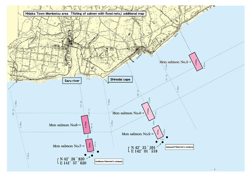
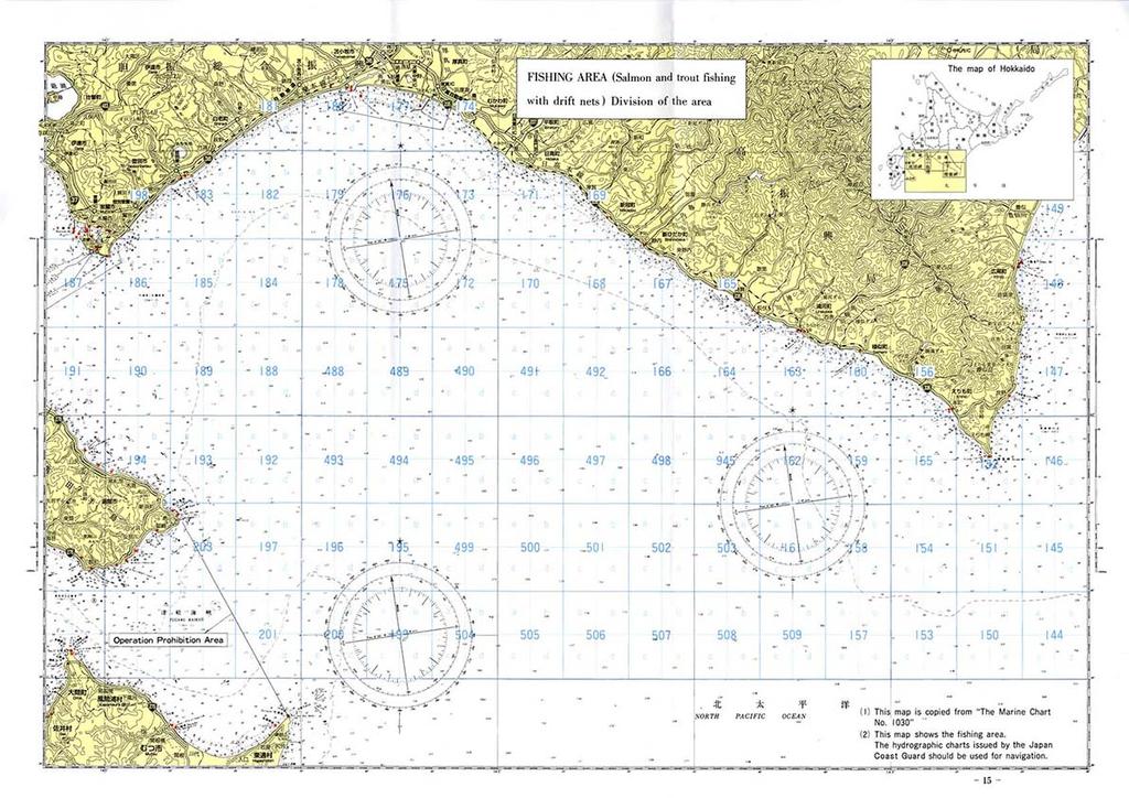
5 II. Operations In this area, salmon with fishing nets, flatfishes and pollacks with gill nets, horsehair crabs and shrimps with fishing baskets, octopus fishing nets with fishhook and fishing methods are used.. Fishing nets A net of about, to 2, meters is always installed on the prescribed sea surface. We catch salmons toward the east from the west on spring and toward the west from the east on autumn with this fishing nets. Cutting accidents occur frequently in Hidaka-Mombetsu area because these fishing nets are offing about 4 nautical miles. Usually the fishing nets should be from the coast (-2 nautical miles). You must care in case of navigation in the west of Tomakomai port, there are some fishing nets offing 2 nautical miles from the shore. () Operations i. Operating period (note: some difference per fishing area) Fishing net case are always placed in operating period. The nets are always placed in this period and are pulled off once to three times a day. Spring: from Mar. 2 to Aug. 2 (Operating from Apr. 6 to Aug.5) Spring to Autumn: from Apr. 5 to Dec. 2 (Operating from Apr. 2 to Jul.3, Spt. to Nov.23) Autumn: from Jun. to Dec. 5 (Operating from Aug.3 to Dec.3) ii. Operating position Operations are done only in the specified area. The specified area is within 2 nautical miles. Although, 4 nautical miles in Hidaka-Mombetsu area. See Fig. p8 iii. Number of the nets Area Eastern-Iburi Hidaka Total Spring Spring to Autumn Autumn Total
6 iv. States of the nets Hand nets (or fence nets) that guides migrating salmon is laid in a direction almost perpendicular to the land, and its length is about, to 2, meters Capturing nets are laid in parallel with land in the offshore, and its width is about 3 to 4 meters These nets are tightly installed with net floats, weights, and wire ropes. (Fig.) v. Operational indicators A large fishing gear sign (flag), a light, a radar reflector, etc. are located around the laying net, although every hand net doesn't have the sign. And all signs are not same. (2) Accidents Most of the accidents are cutting nets or broken net systems by ships. Especially occurs in Hidaka-Mombetsu offshore area. (3) Instructions in the navigation Please sail offshore (more than 3 nautical miles away) since fishing nets are placed near the shore. The net systems are installed continuously and it's very hard to find the net systems. If you need to sail near the shore, you must check them out carefully as much as you can. If you find these nets during sailing, move your ship to the offshore side since the nets are extended to the land side. In case of auto pilot navigation, please have a special care to them.
7 Be care with the fishing nets especially in the Hidaka-Mombetsu area when you make a navigation to the east from Tomakomai port. It's so close to the nets when you make a direction 23 degree from the West Tomakomai Port or about 35 degree from the East Tomakomai port from April to August. You must pay to fix the net systems when you make an accident and break them. Fishing nets are made of high quality parts to be used for long time. Please make a special care when you sail around the area, we don't want you pay for.
8
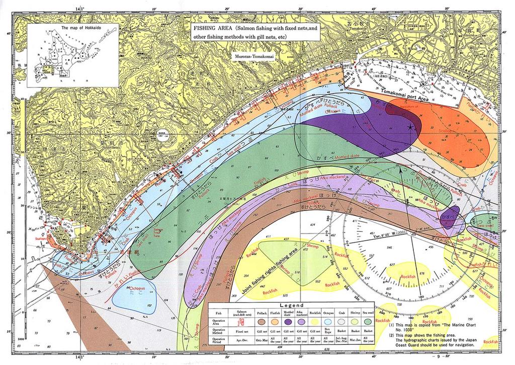
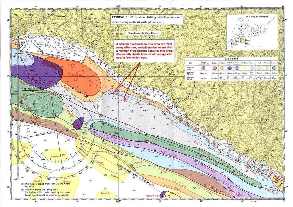
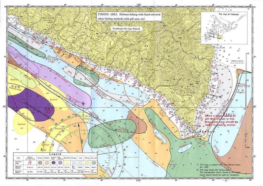
9 2. Fishing nets, baskets, boxes, and octopus fishing We place fishing gear on the bottom of the sea and set a sign of the mark on the sea surface. It will be done in a concentrated location. And they will be done in similar places. Please be care of floating balls for tide or connecting wire ropes around these marks on sea surface. () Operations Many kind of fishery is done all through the year around this area. The fishing implements are always laid during an operation period and is raised once a day. It should be there for days without raising if the wave is too high. Operating positions are on Fig.p9p These nets should be moved for miles for the kind of fishes or operation periods. The fishing methods, operation periods, number of hours of work, etc. of major fish species are as follows: Fish Methods Operation season Peak season Number of approved boats Pollacks Aug. to Mar. Nov. to Feb. 4 Flatfish Whole year May to Jul. 678 Nov. to Jan. Batoidea Gill nets Whole year Apr. To Jul. 342 Nov. to Feb. Hokke Whole year Mar. to Sep. 293 Menuke Whole year Mar. to Sep. 55 Horsehair crab Baskets Jul. to Aug. Jul. to Aug. 8 Dec. to Mar. Jan. to Feb. Prawns/Octopus Mar. to Jan. Mar. to May 48 Aug. to Nov. Whelk Original boxnets Whole year Apr. To Aug. 47 Octopus Boxes/Original Whole year Jul. to Sep. 32 Nov. to Mar. (2) Fishing implements Most of fishing implements are usually sunk in the bottom of the sea. Fishing gear signs(flag) with floating balls are located around the laying net on the sea surface. (Fig.2)
10 Fig. 2 Net Setting In most cases, a red flag is on the shore end. Marker,2,5m Sea Surface In most cases, a black flag is on the offshore end. Box Fishing - approx. 7 m Line Fishing - without bait - approx.,5m Basket Fishing - approx.,2m In most cases, a red flag is on the shore end. Marker Sea Surface In most cases, a black flag is on the offshore end. Boxes Baskets Lines without bait (3) Fishing implements mark There are some signs stipulated by agreement depending on fish species, but it is not particularly regulated. Generally, when laying at right angle to the coastline, red flags are used on the land side, black or white flags on the offshore side are displayed on the sea surface. When laying parallel to the coastline, red flags on the west side and black or white flags at the east side are displayed on the sea surface. (Fig.2) Most of these flags have lights or rador reflectors. (4) Accidents Most of the accidents are cuts or losses of ropes connecting fishing gear signs and floating balls. When the fishing gear signs at both ends disappear, the position of the net becomes unknown and it becomes a big damage. Recently, the ropes are so durable and cannot be cut, that we may lost whole fishing net systems. There are also accidents which seems to be caused by ship anchors. (5) Caution on navigating ships The fishing nets may not be damaged on usual navigation because they are usually laid on the sea floor. But you had better not to navigate this area because so many fishery nets or something are placed around. Please make special caution on the marks to avoid any accidents when you navigate this area. In case of avoiding the marks, please keep sailing on the downstream side as the float is upstream of the tide flow from the sign. You must detour greatly when sailing upstream.
11 Please be careful when dropping the anchor especially around the shore. Especially, around the cape Erimo-misaki, make a big caution on dropping the anchors because so many fishing nets are in the sea. For fishing, bottom trawling, dotted netting etc., we omitted the description in this document because the fishing boat and the fishing gear are integrated in operation, such as hanging the fishing gear from the fishing boat or drawing fishing gear with the fishing boat.
12
13
14
15 3. Salmon and trout drift net fishing - small boat (under 3 tons) This is a one of the major fishery accidents. This fishery nets should be placed near the sea surface to catch salmon and trouts for several kilometers. It s too hard to find these nets because of a heavy fog on the sea in the peak season and some reasons. However, recently, the number of operations has decreased, and the main fishing grounds are off the east coast of Hokkaido (Nemuro and Kushiro area), and operations in the west of Cape Erimo-misaki are decreasing. () Operations i. Operation period (scheduled) From Apr. to Jul.7 In early May, when the surface temperature of the sea water reaches 4 to 5 degrees, the fish school appears from the offshore of Muroran to Tomakomai and moves to Hidaka area gradually. In the latter half of June, they gradually move off to Cape Erimo-misaki and to offshore of Kushiro. The peak period is from mid-may to mid-june where the water temperature will be 7 to degrees. Therefore, the fishing ground will move from the west to the east (from Muroran towards Tomakomai / Erimo) sequentially. ii. Operation time Departing around noon, choosing a fishing ground, starting the casting net from around 5 o clock. It takes about one and half an hour. Lift nets start from about 22 to 24 o'clock and end at about 3 to 4 o'clock, but sometimes it may extend to around 7 o'clock. Normally, it takes about 3 to 4 hours. It depends on fishing situation, returning port time is after 3 o'clock iii. Operation area The operation is carried out targeting at all sea areas. (Fig.p5) The operation position moves by the situation of the fishing ground of the day. At the place where various gill nets fishing is done, the drifting net fishing is not carried out.
16 iv. Operation situations The average length of the net is 5, meters (permission is up to, meters), and the nets are placed about 6 to 7 meters depth from sea surface. These are density packed in good fishing places. Throwing net is done at the stern and lifting net is done at the bow of the fishing boat. (Fig.3,4) The direction of laying nets is done in a direction almost perpendicular to the tidal current, same as coastline. Net directions are North-northwest between Muroran and Tomakomai, North-northeast between Tomakomai and Erimo and are to be separated from the adjacent net by 9 meters or more. They are not constant because they drift after laying them. (Fig.5) Fig. 3 Net Casting Fishing Boat NET Fig. 4 Net Recovery Fishing Boat NET Fig. 5 Operation Direction of Wind Legends: Buoy Fishing Boat Net Fishing Site v. Operation signs When laying net toward the offshore, a large fishing flag or a red flag (m.8m or more) is placed on the stern when laying on the stern, and on the bow when laying toward the land. There are two red flags and red flash lights on both ends of the net, and one red flag and a white flashing light in the middle between 5 and 8 meters. (Fig.6) These flash lights can be delivered in one to two nautical miles. Some radar reflectors are also installed to most of the nets to allow the network to recognize it as a line when viewed on a radar.
17 (2) Accidents Cutting nets accidents have occurred on these areas for many times. Also the main fishing area is eastern Hokkaido these days, but there is concern about the occurrence of accidents such as cutting nets by ships and losing nets in the sea area. (3) Caution on navigating ships To avoid the fishing ground is extremely difficult because the salmon and trout nets are densely laid and so unfindable. Especially, it s extremely difficult to avoid under adverse conditions such as nighttime and heavy fog, please do not sail on fishing grounds that are operating as much as possible. If you should navigate in the fishing area, please strictly observe the watch and sail with full attention. Please make special care when you use automatic navigation. Detour greatly in front of the fishing boat if you find a fishing boat throwing nets (around 5 to 9 o'clock), the net will extend in the stern direction. (Fig.7) And detour greatly behind the stern if you find them lifting nets (around 22 to 4 o clock), the nets will extend in the front of the boats. (Fig.8) When you find the net, you must avoid them and navigate your ship to the place where a red light or fishing boats are. (Fig.9) According to the Article 36 of the Maritime Collision Prevention Law, if you find a ship that approaches the net laid at night, fishing boats will indicate the direction in which the net is laid with a search light etc. Please avoid navigating them. (Fig.) Be careful to operate your ship because there are following nets also after avoid one net in the fishing grounds. Fishing boats in operation are often are connected with the nets, so you can t even make a free navigation. Please detour greatly as soon as possible if you find them.
18
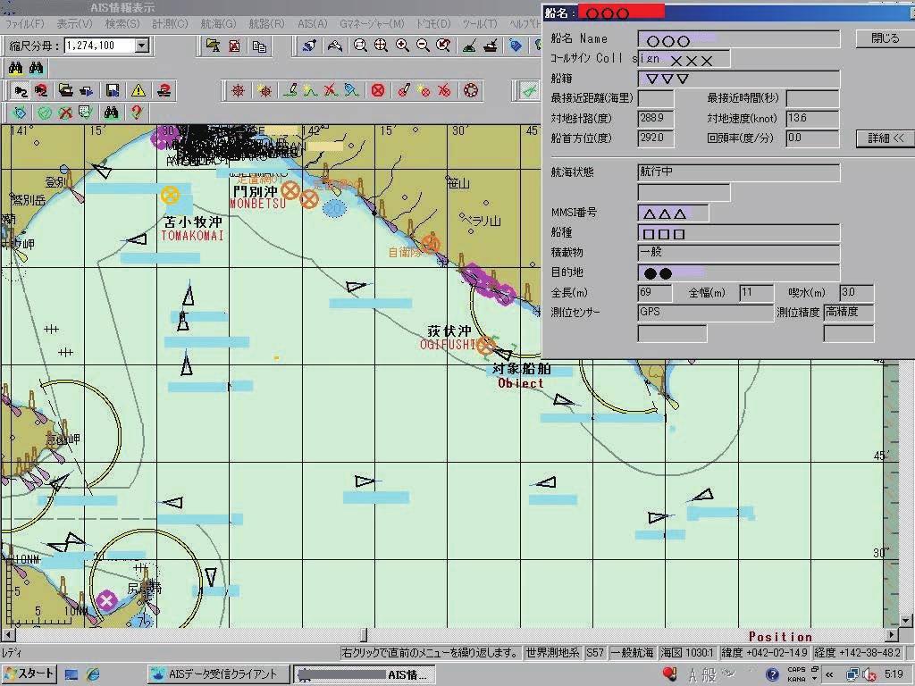
19 . Status grasp and fishing implements damage payment business of the ship The system for maritime accidents and safety communication so far provided sea status information and the like to ships and aimed for quick search operation when marine accidents occurred. Furthermore, in response to the need for a ship and coastal station to automatically transmit and receive information such as ship name, position, course, speed etc. to prevent collision, Automatic Identification System (AIS) has been mandated for ships designated by laws and regulations. With the cooperation of the Hidaka Fishery Radio Station, our association will grasp the ship from the cape Chikyu-misaki to the cape Erimo-misaki and accumulate the data since 2. These data are used for safety measures business. We will improve our system to grasp movement of every ship more from 27. We are engaged in projects to compensate for fishing gear damage such as business to secure operational safety of coastal fishery from ship entering and leaving Tomakomai port and disconnection and loss of fishing gear caused by ship navigation. For fishing gear damage, we have been providing relief funds for the damage of 42 cases in 2. In recent years, although there is a decreasing trend, there are still applications for more than 2 fishing gear damage. We analyze ship movements and will make every effort to make fishermen or fishery persons to raise awareness and calling attention to reduce damages.
20
21 4 97,22 39, ,554 23, ,84 29, ,596 93, ,66 33, , , ,96 2, ,53 9,67 6 2,474 39, ,499 27, ,9 94, ,92 262,432 2,352 6, ,763 69,25 9,5 75, ,49 29,732 66,524 5, ,965 39, ,965 39, ,5 8, ,493 67, ,969 26,4 23,253 6,954 23,253 6,954,833 7, ,86 24, ,5 84,9 5 53,5 84,9 8,48,695 7,64 5, ,85 6, ,85 6, ,99 8, ,99 8, , ,788 67,42, ,3 6 85,5 57, ,598 87, ,8 245,764 97,733, , ,5 42, ,972 29, ,23 332, ,23 332,9 3 3,249 23, ,249 23, ,985 24,4 2,457 3,79 5 8,845 59, ,536,49 2,572 8,68 2,572 8,68 2,572 8, ,83 73,49 8,2 52, ,95 25, ,552 2, ,447 43,628,44,257,79, ,286,256,424, ,493 69, ,885 63,589 47,62,99 634, ,4,833 2,39,597 List of Damage and Benefit of Fishing Category and Fishery Association in 24 Period 24.~242.3 Unit : JPY Total Association Name kojyohama Division Shiraoi Branch Noboribetsu Branch Iburichuo Fisheries Cooperative Association Total Tomakomai Fisheries Cooperative Association Hidaka Ffisheries Cooperative Association Hidakachuo Fisheries Cooperative Association Fisheries Difference
22 Unit : JPY Total List of Damage and Benefit of Fishing Category and Fishery Association in 25 Period 25.~252.3 Association Name Division Fisheries Difference Noboribetsu Branch kojyohama Shiraoi Branch Iburichuo Fisheries Cooperative Association Tomakomai Fisheries Cooperative Association Hidaka Ffisheries Cooperative Association Hidakachuo Fisheries Cooperative Association Total
23 Octopus Box Octopus Line 9 259,872 59, ,2 5, ,984 75,88 Salmon Fixed nets Unit : JPY Total 4 26,279 27, ,95 6, ,5 48,62 72,74, ,33 6,62,276,2, ,69 29,22 6,263,38 68, ,532,899 2,78,6 List of Damage and Benefit of Fishing Category and Fishery Association in 26 Period 26.~262.3 Association Name Division Pollack Gill Net Flatfish Gill Net Paciffic cod Gill Net Mottled Skata Gill Net Atka Mackerel Gill Net Rockfish Gill Net Fisheries Difference Thornyhead Gill Net Ocean Perch Gill Net Shrimp Octopus Basket Crab Basket Sea Snail Basket Noboribetsu Branch 2 8,446 8,867 8,2 3,584 6,72 5,4 kojyohama 4,92,644 9,742 4, ,566 44, ,799 64, ,896 26,842 Shiraoi Branch 4 86,22 57,28 7,332 28,775 47,95 9, ,242 7, ,32 27, ,4 4,398 Iburichuo Fisheries Cooperative Association 4 86,22 57, ,524 39,49 66,937 23, ,88 6, ,565 2, ,52 53,982 Tomakomai Fisheries Cooperative Association 2,68 67, ,47 72,368 3,858 9,8 4 46,526 3,9 9,22 7, ,547 28, ,8 468,524 Hidaka Ffisheries Cooperative Association 2 67,22 3, ,7 5 98,98 97,8 Hidakachuo Fisheries Cooperative Association 3 63,288 33, ,952 65, ,686 88, , ,764 Total 5 88,9 25, , , ,795 32, ,286 58,56 9, ,686 88,24 49,5 2,7 68,468, , , , ,67 3, ,838 46,2 4 57,934 3, ,389 29,839
24 4-2,Irifunecho 3 chome,tomakomai 53-3 Japan
How To Enter Kushiro Port and Things To Be Aware of When Entering
 How To Enter Kushiro Port and Things To Be Aware of When Entering 1.How to enter Kushiro Port (1)How to enter the East Area When entering the port from Nemuro, navigate while maintaining a safe distance
MARITIME AND PORT AUTHORITY OF SINGAPORE SHIPPING CIRCULAR TO SHIPOWNERS NO. 7 OF 2018
 MARITIME AND PORT AUTHORITY OF SINGAPORE SHIPPING CIRCULAR TO SHIPOWNERS NO. 7 OF 2018 MPA Shipping Division 460 Alexandra Road 21 st Storey PSA Building Singapore 119963 Fax: 6375-6231 http://www.mpa.gov.sg
THE REPUBLIC OF LIBERIA LIBERIA MARITIME AUTHORITY
 THE REPUBLIC OF LIBERIA LIBERIA MARITIME AUTHORITY 8619 Westwood Center Drive Suite 300 Vienna, Virginia 22182, USA Tel: +1 703 790 3434 Fax: +1 703 790 5655 Email: safety@liscr.com Web: www.liscr.com
National Maritime Center
 National Maritime Center Providing Credentials to Mariners Q301 Rules of the Road-Inland (Sample Examination) Page 1 of 19 Choose the best answer to the following Multiple Choice Questions. NO reference
Figure 1. Pair trawlers are in operation.
 Fisheries in Thailand in brief The fisheries in Thailand are multi gear and multi species. Fishers use several gear types to capture several fish species. Catches from these types of gear comprise muti
COMPARISON OF FIXED & VARIABLE RATES (25 YEARS) CHARTERED BANK ADMINISTERED INTEREST RATES - PRIME BUSINESS*
 CHARTERED BANK ADMINISTERED INTEREST RATES - PRIME BUSINESS*") COMPARISON OF FIXED & VARIABLE RATES (25 YEARS) Fixed Rates Variable Rates FIXED RATES OF THE PAST 25 YEARS AVERAGE RESIDENTIAL MORTGAGE LENDING RATE - 5 YEAR* (Per cent) Year Jan Feb Mar Apr May Jun Jul
COMPARISON OF FIXED & VARIABLE RATES (25 YEARS) Fixed Rates Variable Rates FIXED RATES OF THE PAST 25 YEARS AVERAGE RESIDENTIAL MORTGAGE LENDING RATE - 5 YEAR* (Per cent) Year Jan Feb Mar Apr May Jun Jul
OSAKA MARTIS USER MANUAL TABLE OF CONTENTS
 OSAKA MARTIS USER MANUAL TABLE OF CONTENTS Ⅰ Ⅱ Ⅲ INTRODUCTION OPERATIONAL CONCEPT OF "Osaka MARTIS" IMPORTANT NAVIGATIONAL RULES Ⅳ COMMUNICATION 1 VHF Channels 2 Language Ⅴ PRE-ENTRY REPORT AND POSITION
Adaptation to climate variation in a diversified fishery:
 Adaptation to climate variation in a diversified fishery: The West Coast groundfish trawl fishery Lisa Pfeiffer Northwest Fisheries Science Center, NOAA Fisheries Seattle, Washington USA The West Coast
Rule 26 - Fishing vessels
 (a) A vessel engaged in fishing, whether underway or at anchor, shall exhibit only the lights and shapes prescribed in this Rule. (b) A vessel when engaged in trawling, by which is meant the dragging through
Commercial Season, Days, Times and Area Restrictions
 Summary of Maryland Commercial Fisheries Regulations FISH HEALTH HOTLINE: 1-888-584-3110 This is an abridged version of the regulations and does not include all regulated species. May not include Emergency
Greenland case study. Nette Levermann Ministry of Fisheries, Hunting and Agriculture
 Greenland case study Nette Levermann Ministry of Fisheries, Hunting and Agriculture Overview of existing knowledge on entanglement of large whales in Greenland Description of the fisheries, regulatory
National Maritime Center
 National Maritime Center Providing Credentials to Mariners (Sample Examination) Page 1 of 19 Choose the best answer to the following multiple choice questions. NO reference materials are authorized for
Japan s report on Paragraph 13, CMM
 Japan s report on Paragraph 13, CMM2016-04 1 Introduction: Overview of Japanese PBF fisheries 2 PBF Catch by fishing gear in Japan 1952 1954 1956 1958 1960 1962 1964 1966 1968 1970 1972 1974 1976 1978
Code of Practise for Deployment and Marking of Fishing Gear
 INTRODUCTION Falmouth Harbour is used for a diverse range of activities including commercial shipping, leisure boating, diving and fishing. The Commissioners aim to accommodate all activities without imposing
Maturity and Spawning of the Small Yellow Croaker, Larimichthys polyactis
 Maturity and Spawning of the Small Yellow Croaker, Larimichthys polyactis Hyunjung Kang Kang 1, Yeonghye Kim 1, Jinkoo Kim 2, Sungyeon Kim 1, Sukgeun Jung 1, Dongwoo Lee 1 National Fisheries Research Development
Bird strikes Swedish Airspace
 Bird strikes Swedish Airspace 1998-2005 Nordic Birdstrike Committee Arlanda 2006-09-21 Jörgen Andersson Jörgen Andersson, Swedish CAA 1 Objective Occurrence reports Bird population Birdstrikes between
SC China s Annual report Part II: The Squid Jigging Fishery Gang Li, Xinjun Chen and Bilin Liu
 3 rd Meeting of the Scientific Committee Port Vila, Vanuatu 28 September - 3 October 215 SC-3-9 China s Annual report Part II: The Squid Jigging Fishery Gang Li, Xinjun Chen and Bilin Liu National Report
Brian Cheuvront, Ph.D. SAFMC Deputy Executive Director for Management
 Brian Cheuvront, Ph.D. SAFMC Deputy Executive Director for Management
6 th Meeting of the Scientific Committee Puerto Varas, Chile, 9-14 September 2018
 6 th Meeting of the Scientific Committee Puerto Varas, Chile, 9-14 September 218 SC6-Doc24 China s Annual Report, part II (Jumbo squid) Gang Li, Bilin Liu, Luoliang Xu & Xinjun Chen Annual Report of China
***This summary does not include shad and herring net requirements.***
 South Carolina Department of Natural Resources Marine Resources Division Summary of Seine and Gill Net Laws (Saltwater) 2013-2014 This document should be kept on board all vessels using seines or gill
Wisconsin 511 Traveler Information Annual Usage Summary January 3, Wisconsin 511 Phone Usage ( )
") Wisconsin 511 Traveler Information 211 Annual Usage Summary January 3, 212 Overall to-date Summary 36 months of operation 1,16,63 total calls the 1 Million mark was passed on December 3, 212 3,627,527
Wisconsin 511 Traveler Information 211 Annual Usage Summary January 3, 212 Overall to-date Summary 36 months of operation 1,16,63 total calls the 1 Million mark was passed on December 3, 212 3,627,527
The Icelandic Information System on Weather and Sea State Related to Fishing Vessels Crews and Stability
 The Icelandic Information System on Weather and Sea State Related to Fishing Vessels Crews and Stability Seminar on Fishing Vessels Crews and Stability World Fishing Exhibition 2009, Vigo Spain September
VEHICLE / PEDESTRIAN COLLISIONS
 VEHICLE / PEDESTRIAN COLLISIONS HRM: April 018 DISCLAIMER: All figures presented in this report reflect the information held on HRP systems at the time of data extraction and are subject to change without
Chile s 2013 CMM 1.01 Implementation Report
 1 st Meeting of the Compliance and Technical Committee, Manta, Ecuador: 27-31 January 2014 Chile s 2013 CMM 1.01 Implementation Report Undersecretariat for Fisheries and Aquaculture CHILEAN COMPLIANCE
Fishing Ground and Abundance Distribution of Kawakawa (Euthynnus affinis) by Purse Seiner Fisheries along the Andaman Sea Coast of Thailand, 2016
 by Purse Seiner Fisheries along the Andaman Sea Coast of Thailand, 2016") Fishing Ground and Abundance Distribution of Kawakawa (Euthynnus affinis) by Purse Seiner Fisheries along the Andaman Sea Coast of Thailand, 2016 Sichon Hoimuk Upper Andaman Sea Fisheries Research and
Fishing Ground and Abundance Distribution of Kawakawa (Euthynnus affinis) by Purse Seiner Fisheries along the Andaman Sea Coast of Thailand, 2016 Sichon Hoimuk Upper Andaman Sea Fisheries Research and
STATUS REPORT FOR THE SUBMERGED REEF BALL TM ARTIFICIAL REEF SUBMERGED BREAKWATER BEACH STABILIZATION PROJECT FOR THE GRAND CAYMAN MARRIOTT HOTEL
 August 23 STATUS REPORT FOR THE SUBMERGED REEF BALL TM ARTIFICIAL REEF SUBMERGED BREAKWATER BEACH STABILIZATION PROJECT FOR THE GRAND CAYMAN MARRIOTT HOTEL performed by Lee E. Harris, Ph.D., P.E. Consulting
Nautical Navigation: Final Quiz
 Name: Nautical Navigation Final Quiz Class: (ver. 03/09/15) Date: Page 1 of 9 Nautical Navigation: Final Quiz There are three sections: Multiple Choice, True/False, and Short Answer. For the multiple choice,
California Current Forage Fishes (Ranked by Biomass of the Group)
") California Current Forage Fishes (Ranked by iomass of the Group) Meso- and bathypelagic fishes - Many short-lived species (lanternfishes, deepsea smelts) Coastal pelagic and migratory fishes -7 mod-lived
California Current Forage Fishes (Ranked by iomass of the Group) Meso- and bathypelagic fishes - Many short-lived species (lanternfishes, deepsea smelts) Coastal pelagic and migratory fishes -7 mod-lived
 Page 1 of 6 Nav-Aid Basics Unlike the roads and highways that we drive on, the waterways we go boating on do not have road signs that tell us our location, the route or distance to a destination, or of
TRAFFIC MANAGEMENT. Traffic Control. Information Signals Remarks. Combination of >=== LO CODE indicating the ports.
 SNPWG 17-10.1C TRAFFIC MANAGEMENT Traffic Control Ships Routeing A Navigation Rules Vessels should observe the following in addition to navigation pursuant to the provisions of Maritime Traffic Safety
2018 HR & PAYROLL Deadlines
 th (by payment date) EPAF 3rd PARTY FEEDS WTE Approval 2018 HR & PAYROLL s Normal Payroll day s 2017 B1-26 3 * 13-Dec-17 15-Dec-17 n/a n/a n/a 28-Dec-17 29-Dec-17 11:00 AM 16-Dec-2017 29-Dec-2017 JAN 2018
Imagine that you can see a side view of a wave as it approaches a beach. Describe how the wave changes as the wave approaches the beach.
 Geology 101 Name Reading Guide for Ch. 19: Shores and Coastal Processes (p. 612) Waves, Currents, and Tides (p. 614) Waves and Currents (p. 614) Imagine that you can see a side view of a wave as it approaches
Bicycle Crashes. Number of Bike Crashes. Total Bike Crashes. are down 21% and severe bike crashes down 8% since 2013 (5 years).
.") Bicycle Crashes The City of Fort Collins is well known for its bike culture, and there is a strong focus on encouraging increased riding. Bike safety is an important component of supporting these efforts.
Bicycle Crashes The City of Fort Collins is well known for its bike culture, and there is a strong focus on encouraging increased riding. Bike safety is an important component of supporting these efforts.
STATE OF THE DOLPHINFISH (CORYPHAENA HIPPURUS L.) FISHERY IN MAJORCA ISLAND IN THE PERIOD
 FISHERY IN MAJORCA ISLAND IN THE PERIOD") STATE OF THE DOLPHINFISH (CORYPHAENA HIPPURUS L.) FISHERY IN MAJORCA ISLAND IN THE PERIOD 2003-2010 A CopeMed II contribution to: CopeMed II - MedSudMed Workshop on Fisheries and appraisal of Coryphaena
STATE OF THE DOLPHINFISH (CORYPHAENA HIPPURUS L.) FISHERY IN MAJORCA ISLAND IN THE PERIOD 2003-2010 A CopeMed II contribution to: CopeMed II - MedSudMed Workshop on Fisheries and appraisal of Coryphaena
The vertical and horizontal distribution of bigeye tuna (Thunnus( albacares) ) related to ocean structure
 ) related to ocean structure") 14 th PICES The vertical and horizontal distribution of bigeye tuna (Thunnus( obesus) ) and yellowfin tuna (Thunnus( albacares) ) related to ocean structure Eun Jung Kim 1,2, Suam Kim 1, Dae-Yeon Moon
14 th PICES The vertical and horizontal distribution of bigeye tuna (Thunnus( obesus) ) and yellowfin tuna (Thunnus( albacares) ) related to ocean structure Eun Jung Kim 1,2, Suam Kim 1, Dae-Yeon Moon
Properties. terc.ucdavis.edu 8
 Physical Properties 8 Lake surface level Daily since 1900 The lowest lake level on record was 6,220.26 feet on Nov. 30, 1992. Since 1900, lake level has varied by more than 10 feet. Lake level typically
SMALL BOAT TUNA LONGLINE FISHERY NORTH-WEST COAST OF SRI LANKA R. Maldeniya
 SMALL BOAT TUNA LONGLINE FISHERY NORTH-WEST COAST OF SRI LANKA R. Maldeniya National Aquatic Resources Agency Crow Island, Colombo 5 Sri Lanka INTRODUCTION Studies made by Sivasubramanium (97) and Maldeniya
Selective Fisheries. What is Selectivity and how is it used in Columbia River Fisheries?
 Selective Fisheries What is Selectivity and how is it used in Columbia River Fisheries? Selective Fisheries What is a Selective Fishery? Mark-Selective Selective: : Harvest limited to retention of fin-marked
American Horseshoe Crabs in the Subtropics: Genetics, Phenotype, Populations, and Marine-Life Harvest
 American Horseshoe Crabs in the Subtropics: Genetics, Phenotype, Populations, and Marine-Life Harvest H. JANE BROCKMANN (University of Florida, Gainesville, FL) TIFFANY BLACK (Florida Fish and Wildlife
Mathematical and Physical Fisheries Science Vol.9 (2011)
") Analysis of relationship between water temperature and catches of longtail tuna and Pacific bluefin tuna off Futaoi Island (western Sea of Japan) using exponential approximation Satoshi Kawatsu *, Masahiko
Analysis of relationship between water temperature and catches of longtail tuna and Pacific bluefin tuna off Futaoi Island (western Sea of Japan) using exponential approximation Satoshi Kawatsu *, Masahiko
World Shipping Council. National Oceanographic and Atmospheric Administration
 Comments of the World Shipping Council Submitted to the National Oceanographic and Atmospheric Administration In the matter of Endangered and Threatened Species; Petition for Rulemaking to Establish a
Applications of Collected Data from Argos Drifter, NOAA Satellite Tracked Buoy in the East Sea
 Applications of Collected Data from Argos Drifter, NOAA Satellite Tracked Buoy in the East Sea Young-Sang Suh (yssuh@nfrdi.re.kr) Ocean Research Team, National Fisheries Research and Development Institute,
Protection for Vessels Engaged in Servicing Submarine Cables
 Protection for Vessels Engaged in Servicing Submarine Cables Proposed Amendments to COLREGS Brief to Navigation Safety Advisory Council November 28, 2012 Tampa, FL Dr. Ronald J. Rapp TE SubCom and Representing
The Wind Observation on the Pacific Ocean for Offshore Wind Farm
 The ind Observation on the Pacific Ocean for ind Farm Manabu TUCHIYA *, Takeshi IHIHARA **, Yukinari FUKUMOTO *** * nvironmental ngineering Division, Kajima Corporation 3-7-1-29F, ishi-shinjuku hinjuku
GUIDE to FISH & FISHING on the NORTH YORK MOORS COAST
 GUIDE to FISH & FISHING on the NORTH YORK MOORS COAST HISTORY Fishing has always played an important part in North Yorkshire s maritime heritage. The industry still plays a significant role in everyday
fisheries in Southern Africa
 Studies of small-scalescale fisheries in Southern Africa Tor F. Næsje and Odd T. Sandlund Norwegian Institute for Nature Research (NINA) tor.naesje@nina.no Long term projects in: Namibia (Since 1993) South
An Atlas of Oceanic Internal Solitary Waves (February 2004) by Global Ocean Associates Prepared for Office of Naval Research Code 322 PO
 by Global Ocean Associates Prepared for Office of Naval Research Code 322 PO") Overview The is located in the western Pacific Ocean north of the Indonesian Island of Celebes and south of the Sulu Sea and the Philippines (Figure 1). It is a deep-water sea, roughly circular with several
Overview The is located in the western Pacific Ocean north of the Indonesian Island of Celebes and south of the Sulu Sea and the Philippines (Figure 1). It is a deep-water sea, roughly circular with several
SEMI FINAL EXAMINATION
 SEMI FINAL EXAMINATION 1. Which vessel may exhibit, if practicable, the lights for sailing vessels, but if she does not, she shall have ready at hand a electric torch or lighted lantern showing a white
Groundfish Harvest Specifications and Management Measures. Tillamook August 6 Newport August 7 Brookings August 12 North Bend August 13
 2015-16 Groundfish Harvest Specifications and Management Measures Tillamook August 6 Newport August 7 Brookings August 12 North Bend August 13 1 (SSC) Scientific and Statistical Committee Groundfish Management
Chart Features Maritime maps and Admiralty charts have these features:
 Introduction to Charts A chart or map of the area is an important safety item to carry on board. It allows the Master to obtain knowledge of the area to be travelled, and indicates the navigable channels
2015 Winnebago System Walleye Report
 215 Winnebago System Walleye Report Adam Nickel, Winnebago Gamefish Biologist, March 216 As winter passes in the rear view mirror, it won t be long until the spring rush of the 216 walleye run is here.
Rules Practice Exam 14
 1 BOTH INTERNATIONAL & INLAND Additional light signals are provided in the Annexes to the Rules for vessels. A. engaged in fishing B. not under command C. engaged in towing D. under sail 2 BOTH INTERNATIONAL
SEMDAC MSC support and surveillance in Chile s EEZ, Desventuradas Islands and Easter Island. Laura Fontan Bouzas Fisheries Analyst, OceanMind
 SEMDAC MSC support and surveillance in Chile s EEZ, Desventuradas Islands and Easter Island Laura Fontan Bouzas Fisheries Analyst, OceanMind INTRODUCTION Established in 2015 Supports fisheries Monitoring,
Evaluating Potential Fishery Effects of Changes to Other Species Management
 Evaluating Potential Fishery Effects of Changes to Other Species Management Analysis Conducted by Scott Miller Economist NOAA Fisheries, Alaska Region, Analytical Team With Contributions by Andy Smoker,
VISUAL SIGNALS (MARKING) ON VESSELS
 ON VESSELS") Annex 3 VISUAL SIGNALS (MARKING) ON VESSELS I. GENERAL 1.1 The sketches which follow relate to the signals (marking) provided for in the articles of chapter 3 of CEVNI, but not to those provided for in,
Annex 3 VISUAL SIGNALS (MARKING) ON VESSELS I. GENERAL 1.1 The sketches which follow relate to the signals (marking) provided for in the articles of chapter 3 of CEVNI, but not to those provided for in,
National Maritime Center
 National Maritime Center Providing Credentials to Mariners (Sample Examination) Page 1 of 7 Choose the best answer to the following Multiple Choice Questions. 1. On a small boat, which knot is best suited
JANUARY 2013 FEBRUARY CONSTB ROP-5 FF-BADV TCNAV / CO GMDSS Optional MED-PIC ARPA MED-PIC MED-PRO BRM BAS-SHS MED-PRO BRM SHS BAS
 2013 OFFICER IN CHARGE OF THE NAVIGATIONAL WATCH (2 ND 3 RD MATE AGT, 500 / 1600 MATE Ocean, Near Coastal, MATE OSV & OFFICER IN CHARGE OF THE NAVIGATIONAL WATCH) JANUARY 2013 FEBRUARY 2013 Dec 31-Jan6
MARINE ACCIDENT INVESTIGATION REPORT
 MARINE ACCIDENT INVESTIGATION REPORT December 8th,2016 Adopted by the Japan Transport Safety Board Member Kuniaki Shoji Member Satoshi Kosuda Member Mina Nemoto Accident Type Contact (light buoy) Date
SS&S Chapter 8 Instructor Guide
 SS&S Chapter 8 Instructor Guide The Rules of the Nautical Road The PowerPoints (PPT) slides for this SS&S chapter were copied from the BS&S-13 th Ed PPT because they are identical. Only the chapter numbers
The Maritime Law Association of Australia and New Zealand
 The Maritime Law Association of Australia and New Zealand Protecting the Environment and Promoting Safe Navigation: Australia s System of Pilotage in the Torres Strait Adam McCarthy Assistant Secretary
ECRR and ARRN Technical Exchange Meeting / ARRN forum 2014 (29 Oct in Vienna, Austria)
") Study on ecological flow of Nanxi River (China) based on ecological conservation objective China Institute of Water Resources and Hydropower Research Beijing Runheng EEI CO., LTD October 29, 214 Overview
Study on ecological flow of Nanxi River (China) based on ecological conservation objective China Institute of Water Resources and Hydropower Research Beijing Runheng EEI CO., LTD October 29, 214 Overview
Figure 1. Structure of Estonian commercial fishing and fish farming in 2010 (% of the total volume)
") Estonia FISHERIES Estonia is a sea and coastal country on the Eastern shore of the Baltic Sea. The territory of Estonia is small 45 227 km 2 the length of our coastline, however, is 3794 km. Good location
Estonia FISHERIES Estonia is a sea and coastal country on the Eastern shore of the Baltic Sea. The territory of Estonia is small 45 227 km 2 the length of our coastline, however, is 3794 km. Good location
Anchoring Is Important
 BCC Sailing Classes - Third Theory Anchoring Anchoring Is Important 1 The Anchor is your last resort. Anchoring Keep off a lee shore. Needs to be shaped (type of anchor) to bury in the type of bottom for
Eastern Equatorial Pacific
 Overview The is the region of open ocean directly south of Mexico and Central America (between approximately 4 o to 16 o N, and 85 o to 105 o W) (Figure 1). Major bathymetric features include Guatemala
A guide to fisheries regulations ENVIRONMENT CORNWALL SEA FISHERIES COMMITTEE. WaW AGENCY
 A guide to fisheries regulations CORNWALL SEA FISHERIES COMMITTEE ENVIRONMENT WaW AGENCY The Fal Estuary and Coastal Area BASS FACTS Bass grow and mature slowly and may not breed until they are 7 years
Hydrographic Surveying Methods, Applications and Uses
 Definition: Hydrographic Surveying Methods, Applications and Uses It is the branch of surveying which deals with any body of still or running water such as a lake, harbor, stream or river. Hydrographic
08 / Industriveien 18 Phone: N Kristiansund Fax:
 Aquaculture Bulletin HEADLINES 08 / 2006 - a guideline for investors in the aquaculture business * Still high prices on the wholesale markets in the EU, with total supply of Atlantic salmon up with 4.6
11426 Moorage Way P.O. Box 368 LaConner, WA Phone: Fax:
 Skagit River System Cooperative 11426 Moorage Way P.O. Box 368 LaConner, WA 98257-368 Phone: 36-466-7228 Fax: 36-466-447 www.skagitcoop.org BULL TROUT USE OF SWINOMISH RESERVATION WATERS Eric Beamer, Rich
Balance in the Bay. An introduction to ecosystem-based management and the Monterey Bay market squid fishery.
 Balance in the Bay An introduction to ecosystem-based management and the Monterey Bay market squid fishery. Original Artwork Ray Troll & NOAA/2008 Fisheries Management Sustaining the greatest number of
Prologue. TSUNAMI - To Survive from Tsunami World Scientific Publishing Co. Pte. Ltd.
 Prologue The Indian Ocean tsunami which occurred on December 26, 2004 caused unprecedented disaster and claimed the priceless lives of more than 300,000 persons worldwide. Among the conditions which contributed
Moor, Tend Mooring And Unmoor Ship - Supervisor Level -
 Marine Terminal Operations Competency Standard Moor, Tend Mooring And Unmoor Ship - Supervisor Level - Industry : Oil, Chemical and Gas Industry Competency Category : 2.0 Moor, tend mooring and unmoor
REGION B ONLY. Figure Figure Figure Figure Figure Figure Figure Figure 10.60
 221 REGION B ONLY 10.5 LATERAL MARKS 10.5.1 Description of Lateral marks Port hand marks Shape: pillar buoy (Figures 10.53 and 10.54), can lighted buoy (Figures 10.55 and 10.56) or not lighted (Figures
Rules Practice Exam 5
 1 BOTH INTERNATIONAL & INLAND Vessel "A" (towing) and vessel "B" are meeting as shown. In this situation, which statement is TRUE? Diagram 12 A. Both vessels should alter course to starboard and pass port
North Carolina Division of Marine Fisheries
 North Carolina Division of Marine Fisheries Presentation to North Carolina Marine Fisheries Commission North Carolina Coastal Recreational Fishing License 2007 Annual Summary January 25, 2008 CRFL Annual
Rules Practice Exam 9
 1 BOTH INTERNATIONAL & INLAND If your vessel is underway in fog and you hear one prolonged and three short blasts, this is a. A. vessel not under command B. sailing vessel C. vessel being towed (manned)
Purple Sea Urchin Barrens
 Purple Sea Urchin Barrens Nancy, Cassie and Jessica Pattern Sea Urchins existing in two stable states. Crevices along coastlines feeding on kelp litter that drifts by Emerged from the crevices creating
Rule 35 - Sound signals in restricted visibility
 Rule 35 - Sound signals in restricted visibility In or near an area of restricted visibility, whether by day or night, the signals prescribed in this Rule shall be used as follows: (a) A power-driven vessel
Enhanced Discussion of Requirements for Commercial Fishing Vessels
 Update on U.S. Commercial Fishing Industry Vessel Requirements Based On Section 604 of the Coast Guard Authorization Act of 2010 (Public Law 111-281) And Section 305 of the Coast Guard and Maritime Transportation
Redondo Pier Alternate Site Activity
 Name: Section: Redondo Pier Alternate Site Activity (Fisherman s Wharf, Redondo Beach, CA 90277) Lab 14C-1 The purpose of this activity is for you to participate in water sampling. We will examine ocean
Inlet Specific and Seasonal Variation in Vessel Use Patterns: The case of the Northeast Florida Region
 Inlet Specific and Seasonal Variation in Vessel Use Patterns: The case of the Northeast Florida Region Nancy Montes Robert Swett University of Florida Automatic Identification System (AIS) Ships 300 or
LAB: WHERE S THE BEACH
 Name: LAB: WHERE S THE BEACH Introduction When you build a sandcastle on the beach, you don't expect it to last forever. You spread out your towel to sunbathe, but you know you can't stay in the same spot
SCIENTIFIC COMMITTEE SEVENTH REGULAR SESSION August 2011 Pohnpei, Federated States of Micronesia
 SCIENTIFIC COMMITTEE SEVENTH REGULAR SESSION 9-17 August 2011 Pohnpei, Federated States of Micronesia CPUE of skipjack for the Japanese offshore pole and line using GPS and catch data WCPFC-SC7-2011/SA-WP-09
Reducing Risk of Whale Entanglements in Oregon Dungeness Crab Gear
 Session 3 Reducing Risk of Whale Entanglements in Oregon Dungeness Crab Gear CaseID: 20150703Mn NMFS MMHSRP Permit #: 18786 Overview West Coast Information Framing the problem Summary of West Coast large
Pre-visit Package (2015 update) Fishy Business
 Fishy Business") Gulf of Georgia Cannery National Historic Site of Canada 12138 Fourth Ave. Richmond B.C. V7E 3J1 cannery.bookings@pc.gc.ca (604) 664-9234 Pre-visit Package (2015 update) Fishy Business Grade(s): 2-3 Duration:
Gulf of Georgia Cannery National Historic Site of Canada 12138 Fourth Ave. Richmond B.C. V7E 3J1 cannery.bookings@pc.gc.ca (604) 664-9234 Pre-visit Package (2015 update) Fishy Business Grade(s): 2-3 Duration:
SAILING INSTRUCTIONS. Port of Los Angeles Harbor Cup Cal Maritime Invitational Intercollegiate Regatta March 9 th -11 th, RULES
 SAILING INSTRUCTIONS Port of Los Angeles Harbor Cup Cal Maritime Invitational Intercollegiate Regatta March 9 th -11 th, 2018 1 RULES 1.1 The regatta will be governed by the ICSA Procedural Rules (PR),
Utility Debt Securitization Authority 2013 T/TE Billed Revenues Tracking Report
 Utility Debt Securitization Authority 2013 T/TE Billed Revenues Tracking Report Billing Budgeted Billed Dollar Percent Month Revenues Revenues Variance Variance Jan 2018 11,943,180.68 12,697,662.47 754,481.79
Pioneer Array Micro-siting Public Input Process Frequently Asked Questions
 Pioneer Array Micro-siting Public Input Process Frequently Asked Questions The National Science Foundation (NSF) has completed the micro-siting of the moored array of the Ocean Observatories Initiative
The fishery for jack mackerel in the Eastern Central Pacific by European trawlers in 2008 and 2009
 Eighth International Meeting: SWG: Jack Mackerel Sub-Group SP-08-SWG-JM-01 The fishery for jack mackerel in the Eastern Central Pacific by European trawlers in 2008 and 2009 Ad Corten Corten Marine Research
Gulf States Marine Fisheries Commission. Dave Donaldson Assistant Director
 Gulf States Marine Fisheries Commission Dave Donaldson Assistant Director Interjurisdictional Fisheries Program The purpose of the IJF Program: Promote and encourage state activities in support of management
SWG JACK MACKEREL FISHERY IN CHILE
 SWG-10-07 JACK MACKEREL FISHERY IN CHILE ANNUAL NATIONAL REPORT SCIENCE WORKING GROUP 2011 1. DESCRIPTION OF THE FISHERY. 1.1 Composition of the Fleet. The structure and size of the industrial purse seine
2014 Advantage Boating Sail Canada Basic Cruising Standard. Section III: Part B Safety Safety Guidelines and Avoiding Hazards
 Section III: Part B Safety Safety Guidelines and Avoiding Hazards Lesson Outline Lesson Objectives Introduction Navigation lights Distress signals Hazards Radar reflector Summary Quiz 2 Lesson Objectives
= new from the previous year = deleted from the previous year
 Summarized History of Oregon Marine Sport Fishing Regulations - Page 1 of 12 2017 Descending devices are mandatory. Any vessel fishing for, or possessing, bottomfish (groundfish) in the ocean must have
Recommended Fish Handling Guidelines for Bass Tournaments in Alabama Waters
 Recommended Fish Handling Guidelines for Bass Tournaments in Alabama Waters Damon Lee Abernethy Fisheries Development Coordinator and Brian Rinehard Fish Hatchery Coordinator Alabama Department of Conservation
HOUSTON SEA CHEST CLOGGING SURVEY
 HOUSTON SEA CHEST CLOGGING SURVEY *** YOUR HELP IS VOLUNTARY AND ANONYMOUS*** ***PLEASE DO NOT INCLUDE VESSEL NAME OR NUMBER *** IT IS 2015 MENHADEN SEASON IN THE HOUSTON SHIP CHANNEL To Vessel Master/Chief
properly applied assessment in the use.1 landmarks.1 approved in-service of ECDIS is not experience The primary method of fixing required for those
 STCW Code Table A-II/3 Specification of minimum standard of for officers in charge of a navigational watch and for masters on ships of less than 500 gross tonnage engaged on near-coastal voyages Ref: https://www.edumaritime.net/stcw-code
Sailing Course Calendar 2017
 If you have never sailed, the ideal introduction is our practical Keelboat Start Crewing and Start Helming courses with sets of 3 hour practical lessons conducted on our International J24 yachts. You will
SAFETY OF NAVIGATION STANDARDS IN THE PORTS OF NAUTICAL TOURISM WITH A SPECIAL FOCUS ON THE MAINTENANCE OF THE PORT ORDER
 SAFETY OF NAVIGATION STANDARDS IN THE PORTS OF NAUTICAL TOURISM WITH A SPECIAL FOCUS ON THE MAINTENANCE OF THE PORT ORDER Ranka Petrinović, Ph. D, Full Professor Nikola Mandić, Ph. D, Assistant Professor
2013 Annual Report on Aquaculture in Japan (Draft)
") 2013 Annual Report on Aquaculture in Japan (Draft) UJNR Japan Panel 1. Introduction This report showed the latest topics in aquaculture, trends in production volume of major aquaculture species, and the
2013 Annual Report on Aquaculture in Japan (Draft) UJNR Japan Panel 1. Introduction This report showed the latest topics in aquaculture, trends in production volume of major aquaculture species, and the
Olympic National Park Fishing and Shellfish Regulations
 Olympic National Park Fishing and Shellfish Regulations Effective May 1, 2008 through April 30, 2009 Olympic National Park is managed as a natural area. The primary objectives of the fisheries management
Figure 4, Photo mosaic taken on February 14 about an hour before sunset near low tide.
 The Impact on Great South Bay of the Breach at Old Inlet Charles N. Flagg and Roger Flood School of Marine and Atmospheric Sciences, Stony Brook University Since the last report was issued on January 31