Habitat Assessment of the Lower Eklutna River. May 14, 2007
|
|
|
- Marshall Turner
- 5 years ago
- Views:
Transcription


1 Habitat Assessment of the Lower Eklutna River May 14, 2007 Prepared For: United States Army Corps of Engineers Civil Works Branch Environmental Resource Section P.O. Box 6898 Elmendorf AFB, AK Prepared By: Prince of Wales Tribal Enterprise Consortium P.O. Box 225 Haines, AK May Habitat Assessment of the Lower Eklutna River
2 Table of Contents Page INTRODUCTION... 3 WATERSHED OVERVIEW... 3 METHODS... 5 SAMPLING STRATEGY... 5 HABITAT ASSESSMENT COMPONENTS... 6 BIOLOGICAL INVENTORY... 8 DATA RESULTS... 8 ANALYSIS OF HABITAT ASSESSMENT RESULTS... 9 BIOLOGICAL INVENTORY RESULTS...19 RECOMMENDATIONS...20 REFERENCES...23 Attachments...24 A1. PowerPoint Presentation of results December 8, A2. Photolog...26 A3. CSSHRM...26 A4. Raw Data...26 A5. Electronic files of this report...26 B1. Data Collection Sheets...27 B2. Data Collection Equipment...30 B3. Level IV Habitat Types...32 B4. Shelter Values...34 C1. Aerial Photograph of Lower Eklutna River System...36 C2. Reach Summary...38 C3. Charts...43 C4. Summary of NVE Fish Counts...54 D1. Photolog...56 D2. Stream Channel Delineation Forms...85 D3. Habitat Inventory Forms...93 D4. Field Drawings Figure 1. Eklutna Watershed... 4 Figure 2. Aerial Photograph of Lower Eklutna System...10 Figure 3. Lower Eklutna System...11 Figure 4. Reach 1 Unit Figure 5. Reach 2 Unit Figure 6. Lower Reach 3 Unit Figure 8. Reach 4 Unit Figure 9. Thunderbird Creek Reach 1 Unit Figure 10. Reach 5 Unit Figure 11. Reach 6 Unit Figure 12. Aerial Photograph of the Lower Eklutna River System...37 May Habitat Assessment of the Lower Eklutna River
3 INTRODUCTION A habitat assessment of the Lower Eklutna River and Thunderbird Creek located in Chugiak, Alaska was conducted August 21-24, The survey began at the mouth of the Eklutna River in the Knik Arm of Upper Cook Inlet and continued to approximately a quarter mile above the Lower Eklutna Dam. It also included Thunderbird Creek from its confluence with Eklutna River to the falls. The length of assessment totaled 5 miles of river channel. Elijah Donat MS, Environmental Engineer and William Prisciandaro, BS Fisheries Biologist were in charge of the data collection, processing, and analysis. The goal of the survey was to assess the habitat available to salmon. The goal of this report is to evaluate the current habitat conditions and recommend options for the enhancement of habitat for all species of salmon. Data included in this document was presented to the Army Corps of Engineers (ACOE) and the Eklutna River Watershed Council on December 8, 2006 and discussed prior to draft document preparation (Attachment A). WATERSHED OVERVIEW The Eklutna River is approximately 12 miles in length from its mouth at the Cook Inlet to the former outlet of Eklutna Lake. The river mouth is on the Upper Knik Arm of Cook Inlet at N W /-9 ft. The river drains from the glacial Chugach terrane, with the peninsular terrane to the west. It then passes through metamorphosed basalts and cherts of an early Jurassic volcanic chain. The river then enters the Upper Cook Inlet after passing through one kilometer of elevated tidal mudflats. Thunderbird Creek is the only significant tributary to the Eklutna River below the Lower Eklutna Dam. Due to water diversion from Eklutna Lake, Thunderbird Creek is currently the main source of water in the river. Eklutna River historically drained a watershed of 174 square miles. The river currently drains a watershed of 55 square miles with the remaining 119 square miles diverted at the lake (Figure 1). The watershed varies from a tidal wetland consisting of mostly grasses and sedges to mountain sides covered with a mixed forest. The Alaska Department of Fish and Game anadromous stream catalogue number is and states five species of Pacific salmon use the river. Thunderbird Creek is catalogued as May Habitat Assessment of the Lower Eklutna River

4 Figure 1. Eklutna Watershed Native Village of Eklutna (NVE) is the last of eight traditional Athabascan villages in the Anchorage area. It is located in Southcentral Alaska, along the Knik Arm of the Upper Cook Inlet, 25 miles northeast of Anchorage. The village and surrounding area maintain a rural character, which the Tribe strives to perpetuate. Subsistence helps connect Eklutna villagers with each other and their traditionally used lands. NVE members strongly support pursuits to preserve their traditional lands, air, water, animals, birds, fish and plants. According to traditional knowledge documented by Tribal elders, the Eklutna River was once a primary subsistence site for the Eklutna Denai na Athabascan Village, offering bountiful salmon runs. The river is central to the village cultural identity, subsistence economy, and responsible natural resources development plans. The river today has been severely degraded as salmon habitat, although all Alaska salmon species are still present. Many problems result from low flow. An assessment is needed to determine habitat potential for the river and lake, and to consider removal of the dam in order to return some of the flow to the river. Unless access to the lake for sockeye is restored and determined to be suitable for spawning and rearing this species has little potential in the system. While king and coho persist in the system they are limited by overwintering, rearing and spawning habitat. Pink and chum salmon are best adapted to the current systems because their lifecycles do not require rearing habitat or overwintering. The NVE is pursuing ecosystem level research, as well as negotiation and planning approaches toward river restoration goals. May Habitat Assessment of the Lower Eklutna River
5 The Eklutna River watershed has been impacted by a series of development projects. The Lower Eklutna Dam, built in the 1920 s for power generation, is one-mile above the village. No longer used, it still blocks all fish passage upriver. This dam was abandoned after the Eklutna Lake Dam, 8 miles up from the lower dam at the mouth of the lake, was completed in This new dam replaced an earthen dam built in conjunction with the Lower Eklutna Dam in the 1920 s. Currently, the Snettisham Purchase Agreement of 1989 allows this dam to stop the outflow of 100% of the lake water. This water is then used for power generation (about 430 cubic feet per second (cfs)), and for Municipality of Anchorage water use (about 70 cfs). Eklutna Lake contains 15.5 miles of shoreline, 3,162 surface acres, and a volume, at 860 feet elevation, equaling 366,048 acre-feet. The river regenerates to around 10% of its historical flow by the time it passes Eklutna Village. Thunderbird Creek contributes about 85% of this flow at its confluence with the river below the Lower Eklutna Dam. Gravel mining in the lower river, most recently by the former Federal Railroad in the 1980s, left 2/3 of a square mile of denuded landscape. The river has reclaimed this area. A complex pond system partially connected to the river, has formed as a result of the gravel mining, along with tidal and groundwater influences. These pools provide summer rearing habitat for juvenile salmon and staging habitat for osmoregulation in adult salmon (Figure 2). METHODS The habitat inventory conducted in Eklutna River follows the methodology presented in the California Salmonid Stream Habitat Restoration Manual (CSSHRM) (Flosi et al., 1998). This manual formally explains and describes the California Department of Fish and Game s ground level approach to restoration of fishery resources and standardizes the descriptive terminology and technical methods (Attachment A). The manual has been used on the Pacific coast to assist in developing salmon habitat restoration techniques. ACOE requested this method because it defines channel characteristics and identifies potential restoration opportunities aimed at increasing spawning and freshwater survival of rearing juveniles. In addition to the CSSHRM methods, residual pool depth was calculated to assess pool depth independent of flow. The habitat inventory was conducted by a two-person team August 21-24, 2006, walking from the mouth of the Eklutna River to approximately a quarter mile above the Lower Eklutna Dam. The assessment includes an analysis by reach of the habitat conditions based on the habitat types. SAMPLING STRATEGY The field protocol was conducted as specified in the CSSHRM. Some modifications were introduced to obtain a more detailed dataset. These modifications to the field protocol include a complete census of habitat units and a photolog by habitat unit. May Habitat Assessment of the Lower Eklutna River
6 The census of all habitat units was a professional judgment made in the field in order to describe more accurately the features of each habitat unit. This is a variation from the 10% sampling size proposed in the CSSHRM, which calls for the selection of one habitat unit to be randomly selected off of each habitat unit form and all parameters measured. The census conducted produced a complete set of measurements for each of the habitat units encountered within the survey. A photolog was produced to illustrate all habitat units by reach. A photolog showing unit numbers and habitat type descriptions is included in Attachment A and D. This will assist in identifying sources of materials for later restoration efforts. It will also facilitate comparisons under different flow regimes to show what features appear and disappear as flow changes. Habitat Assessment Components The habitat assessment has two components: the delineation of channel types and the inventory of habitat units. Data sets for both components were collected using standard field forms and standard field equipment (Attachment B). The channel type delineation included data on channel entrenchment, bankfull width, sinuosity, substrate composition and water slope gradient. A channel type form was filled out at the beginning of the survey and each time the channel type changed. The habitat inventory included data collection on habitat types, temperature, embeddedness, flow, shelter, substrate composition, bank composition and canopy cover. Channel Type Delineation Channel typing was conducted following the CSSHRM which was derived from Rosgen (1994). Channel typing is conducted simultaneously with habitat typing and follows a standard form to record measurements and observations (Attachment B). Five parameters were measured to determine channel type: Water slope gradient: Gradient was calculated using USGS maps because of sinuosity and gradients generally below 2%. Entrenchment: The ratio between flood-prone width and bankfull width. Width/depth ratio: The ratio of the bankfull width to the mean bankfull depth. Substrate composition: The most common particle found on the bed of the stream measured at the velocity crossover. Substrate composition for each habitat unit was also assessed at areas throughout the unit. Sinuosity: The ratio between stream length and valley length. Sinuosity can be estimated from a 7.5 minute topographical map by measuring the lengths of the valley and the stream. May Habitat Assessment of the Lower Eklutna River
7 Habitat Typing Habitat typing uses the 24 habitat classification types defined by McCain et al. (1990). Habitat units are numbered sequentially and assigned a type selected from a standard list of 24 habitat types (Attachment B3). Eklutna River habitat typing used standard basin level measurement criteria. The parameters require that the minimum length of a described habitat unit must be equal to or greater than the stream's mean wetted width. All measurements are in feet. Temperature Both water and air temperature were measured and recorded throughout the survey. Both temperatures were taken in degrees Celsius at the middle of the habitat unit and within one foot of the water surface. Flow Flow for the river system was obtained from the United State Geological Service (USGS) stage gauge located at the Old Glenn Highway Bridge, Latitude 61 27'01", Longitude '02" NAD27, which was installed by the USGS in May of Embeddedness The depth of embeddedness in pool tail-out areas was visually estimated by the percent of surrounded or buried in fine sediment. The values were recorded using the following ranges: 0-25%, 26-50%, 51-75%, and %. Instream Shelter Rating Instream shelter is composed of those elements within a wetted stream channel that provide juvenile salmonids protection from predation, reduce water velocities so fish can rest and conserve energy and allow separation of territorial units to reduce density related competition for prey. Percent of unit cover is the percentage of a unit occupied by several types of cover. Cover is classified into nine types and includes small woody debris, large woody debris, aquatic vegetation, terrestrial vegetation, bedrock ledges, bubble curtains, boulders, root mass and undercut banks. A standard qualitative shelter value of 0 (none), 1 (low), 2 (medium), or 3 (high) was assigned according to the complexity of the cover (Attachment B4). From this, an instream shelter rating can be calculated by multiplying the shelter value by the percent of cover. Thus, instream shelter ratings can range from and are expressed as mean values by habitat types within a stream. Mean shelter ratings were calculated by reach for flatwater and pool habitat types (Attachment B3). Substrate Composition Substrate composition ranges from silt/clay sized particles to boulders and bedrock elements. In all habitat units, dominant and sub-dominant substrate elements were estimated using a list of seven size classes (silt, sand, gravel, small cobble, large cobble, boulders, and bedrock) and recorded as percentages. In addition, the dominant substrate composing the pool tail-outs is recorded for each pool. May Habitat Assessment of the Lower Eklutna River
8 Canopy Density Canopy density relates to the amount of stream shaded from the sun and was estimated from the center of every habitat unit. In addition, the area of canopy was estimated into percentages of coniferous or deciduous trees. Bank Composition Banks were described based on their dominant substrate composition (bedrock, boulder, cobble/gravel, and silt/clay/sand) and based on their dominant vegetation type (grass, brush, deciduous trees, coniferous trees, or no vegetation). These factors were evaluated because they influence the ability of river banks to withstand flows. The dominant composition type and the dominant vegetation type for both the right and left banks at each habitat unit were recorded in the habitat inventory form. Additionally, the percent of each bank side covered by specific vegetation (including downed trees, logs, and root wads) was estimated and recorded. Biological Inventory No biological inventory was conducted as part of this project although observed living and dead fish and wildlife were documented. NVE conducted fish counts for the years of 2002 through 2003 and a summary of that data is located in Attachment B. Data Results The habitat unit inventory dataset is summarized by reach using Microsoft Excel spreadsheets and includes several calculations to characterize the habitat units by reach. A summary of data for each reach is included in Attachment C2. A reach summary table is provided at the end of each reach result. Charts of several parameters measured were created for comparison of reaches. The charts include: Level IV Habitat Types by Percentage Total Length by Reach (Attachment C Chart 1) Level IV Habitat Types by Percent Occurrence by Reach (Attachment C Chart 2) Level IV Habitat Types by Percentage Area by Reach (Attachment C Chart 3) Level II Habitat Types by Percent Occurrence by Reach (Attachment C Chart 4) Level II Habitat Types by Percentage Total Length by Reach (Attachment C Chart 5) Level II Habitat Types by Percentage Area by Reach (Attachment C Chart 6) Pool Depth by Reach (Attachment C Chart 7) Substrate Composition in Pool Tail-outs by Reach (Attachment C Chart 8) Percentage Dominant Bank Composition by Reach (Attachment C Chart 9) Percentage Dominant Bank Vegetation by Reach (Attachment C Chart 10) May Habitat Assessment of the Lower Eklutna River
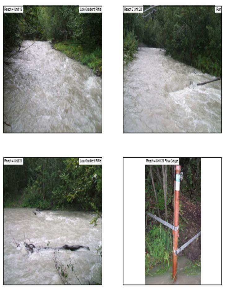
9 The entered field data and raw field data sheets are located on CD in Attachment A. The channel delineation dataset is summarized in Table 1, which is based on data collected in the Standard Stream Channel Type Form. Analysis of Habitat Assessment Results The length of stream surveyed was 25,309 feet, with the survey ending 1,782 feet upstream of the Lower Eklutna Dam. The survey also included the first reach of Thunderbird Creek which measured 1,080 feet. The Eklutna River was then divided into 6 distinct reaches (Figure 2) based on changes documented in the physical characteristics (Table 1) and then divided into 111 habitat units. A photolog is included featuring each habitat unit of the reaches discussed below (Attachment A). Table 1. Channel Delineation Summary by Reach Reach 1 Reach 2 Reach 3 Reach 4 Thunderbird Creek Reach 1 Reach 5 Reach 6 Single/Multiple Channel Single Multiple Multiple Single Single Single Single Entrenchment Width/Depth Gradient <1 <1 <1 <1 1 <1 <1 Substrate Silt/Clay Silt/Clay Cobble Cobble Cobble Silt/Clay Sand Sinuosity The Eklutna River system changes from a single channel to a multichannel river and then back to a single channel as one moves from the mouth upstream. The entrenchment of the river remains consistent throughout with the exception of Reach 4. It contains the largest amount of flow in the most constrained area of the river. The width/depth ratio of the channel changes depending on how constrained the channel is within the reaches. Reach 1 and Thunderbird Creek Reach 1 show the lowest ratio values because of the constraints of the channel allowing for very little movement of the channel. Gradient of the entire system stays around 1 percent or less. The substrate of the river is directly influenced by the tides and obstructions found within the system. Reach 1 and 2 have a silt substrate from the tidal deposition of silt. Reaches 3, Reach 4, and Thunderbird Creek Reach 1 have a cobble substrate from the movement of materials down the canyon. Reach 5 and 6 have a silt and sand substrate because the Lower Eklutna Dam has inhibited the transportation of material to Reach 5 and the Upper Eklutna Dam stopped the natural flow regime which would deposit gravels in Reach 6. Sinuosity values are consistent throughout the Eklutna system with a small increase in the lower braided sections of the river. May Habitat Assessment of the Lower Eklutna River

10 Figure 2. Aerial Photograph of Lower Eklutna System

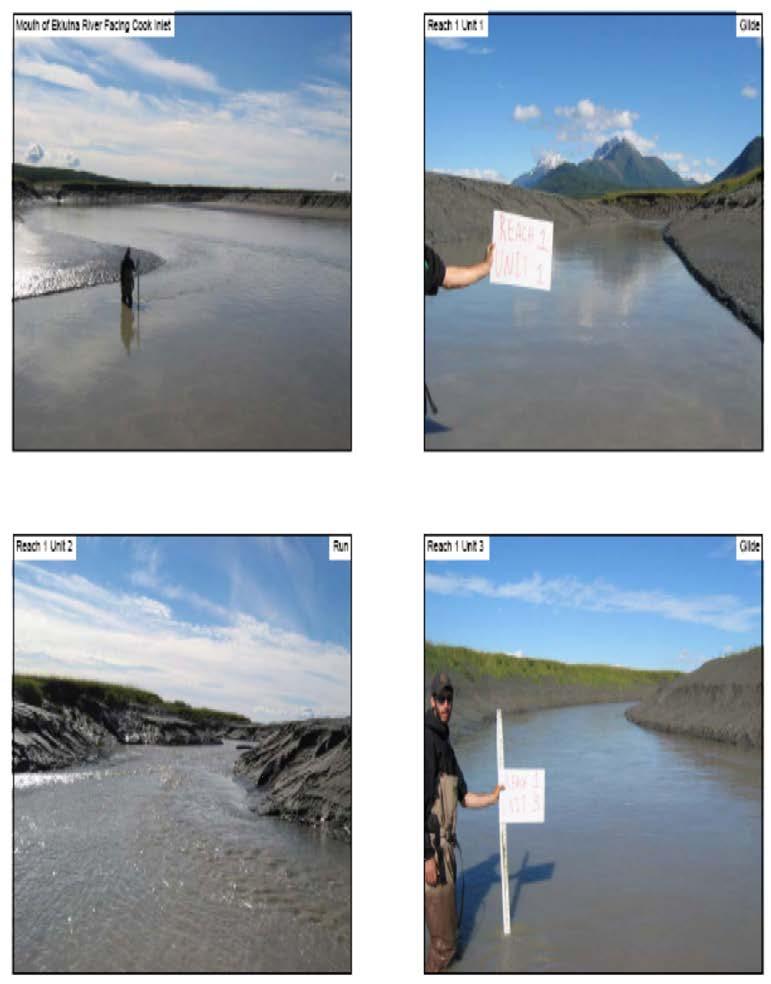
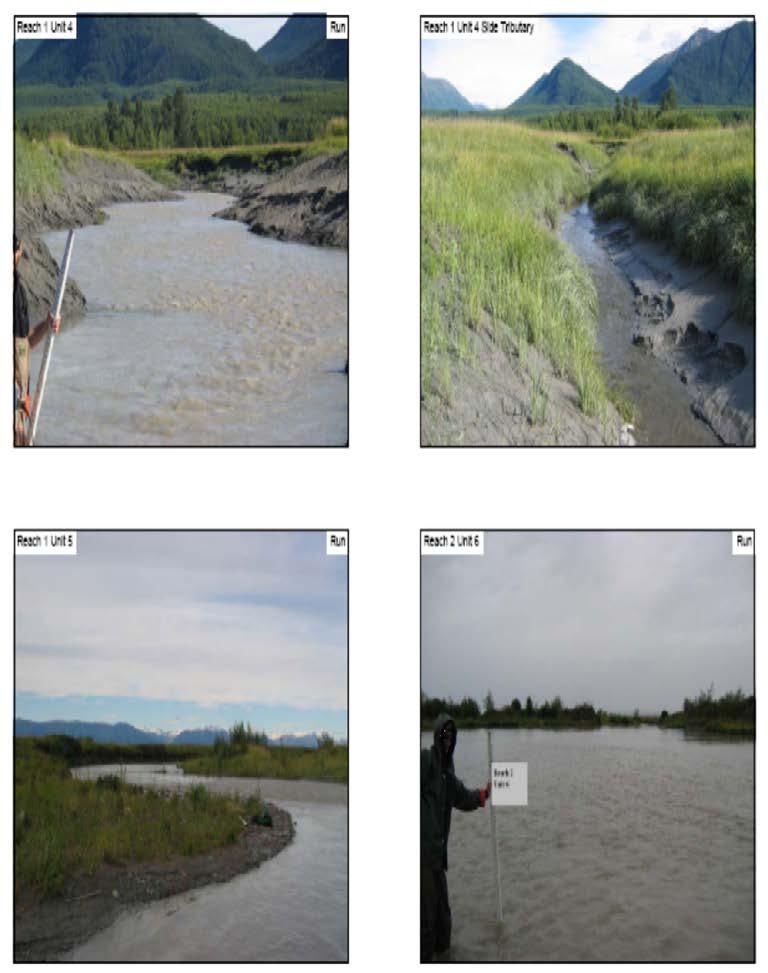
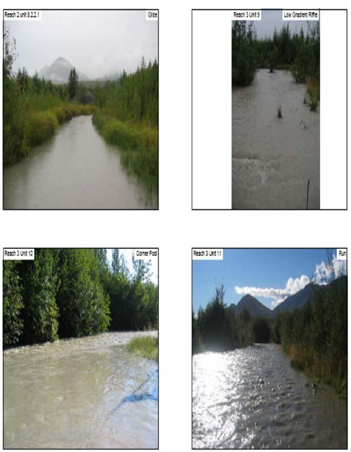
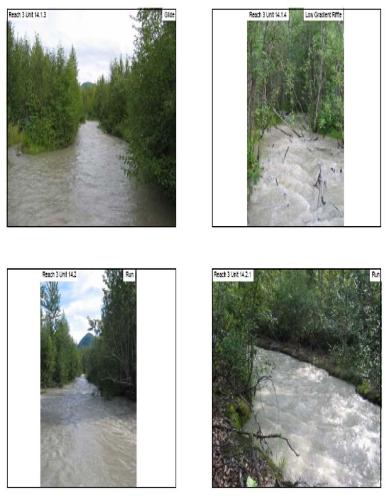
11 Reach 1 Reach 1 measures 3,720 feet, covering an area of 182,010 ft 2 from the mouth of the river up to and not including the lower ponds (Figure 2 and 3). This reach is defined by the large tidal range of the Upper Cook Inlet where tides often range up to 30 feet. Reach 1 is made up of runs and glides by area, 73% and 27% respectively, with a dominant substrate and bank composition of silt (Table 2). There is no instream shelter in this reach. Reach 1 is tidally influenced, has no stable banks and there is no vegetation present (Figure 3). This reach contained no shelter values for any habitat type. This section of the river is used mostly for the passage of fish into the system to spawn and migration of juveniles out into Cook Inlet. It is possible that some juvenile salmon could rear and that pink salmon could spawn in the upper portion of this reach. The highly dynamic tidally influenced banks make for no needed restoration in this reach. Figure 3. Lower Eklutna System showing ponds and monitoring wells An enlarged version of Figure 3 is located in Attachment B May Habitat Assessment of the Lower Eklutna River
 Mean Length (ft) Mean Width (ft) Mean Depth (ft) Mean Max")
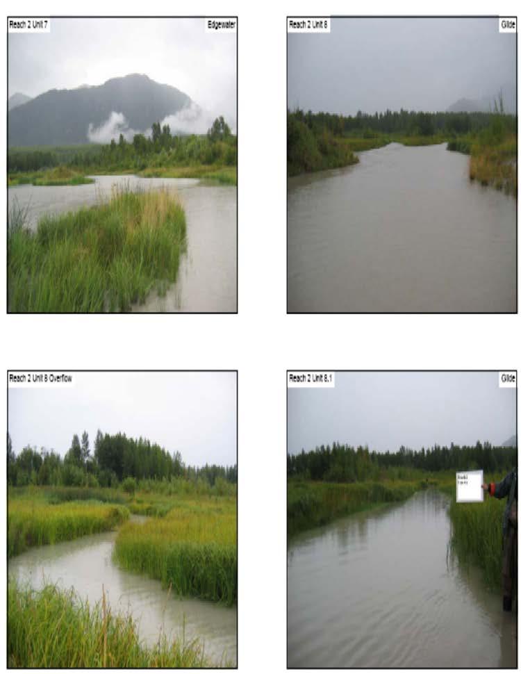
12 Table 2. Summary of Pool, Riffle, and Flatwater Habitat Types for Reach 1 Habitat Type Habitat Units Habitat Percent Occurrence Total Length (ft) Mean Length (ft) Mean Width (ft) Mean Depth (ft) Mean Max Depth (ft)* Mean Depth Pool Tail Mean Total Area (ft)2 Mean of Crest (ft) Area (ft)2 Averages Mean Residual Depth (ft) Run 3 60% 2, N/A N/A 44, ,130 N/A 0 Glide 2 40% 1, N/A N/A 24,440 48,880 N/A 0 Total 5 100% 3, ,010 *Max Depth, Pool Tail Crest Depth, and Residual Depth are only for pool habitats Mean Shelter Rating Figure 4. Reach 1 Unit 2 run area showing silt dominated banks barren of vegetation. Reach 2 Reach 2 measures 3,496 feet including the length of all side channels, covering an area of 212,860 ft 2 from the lower ponds to the area of highest tidal reach (Figure 2 and 3). This section is made up of mostly glides, six (6), and runs, three (3). It contains a large pond area considered an edgewater which helps to dissipate the effect of the high tides. Adult salmon use this area as a holding area before they move upstream to spawn. The ponds are also used as a feeding area for juvenile salmon. There are two edgewaters in this reach; they comprise 50% of the area, with runs 26%, glides 22%, and corner pools 2% (Table 3). Instream shelter is limited to one unit having a rating of 5. The channels within this reach have relatively stable silt banks vegetated 100% by grasses with wetlands that are inundated during high water events providing shelter and rearing habitat for juvenile May Habitat Assessment of the Lower Eklutna River

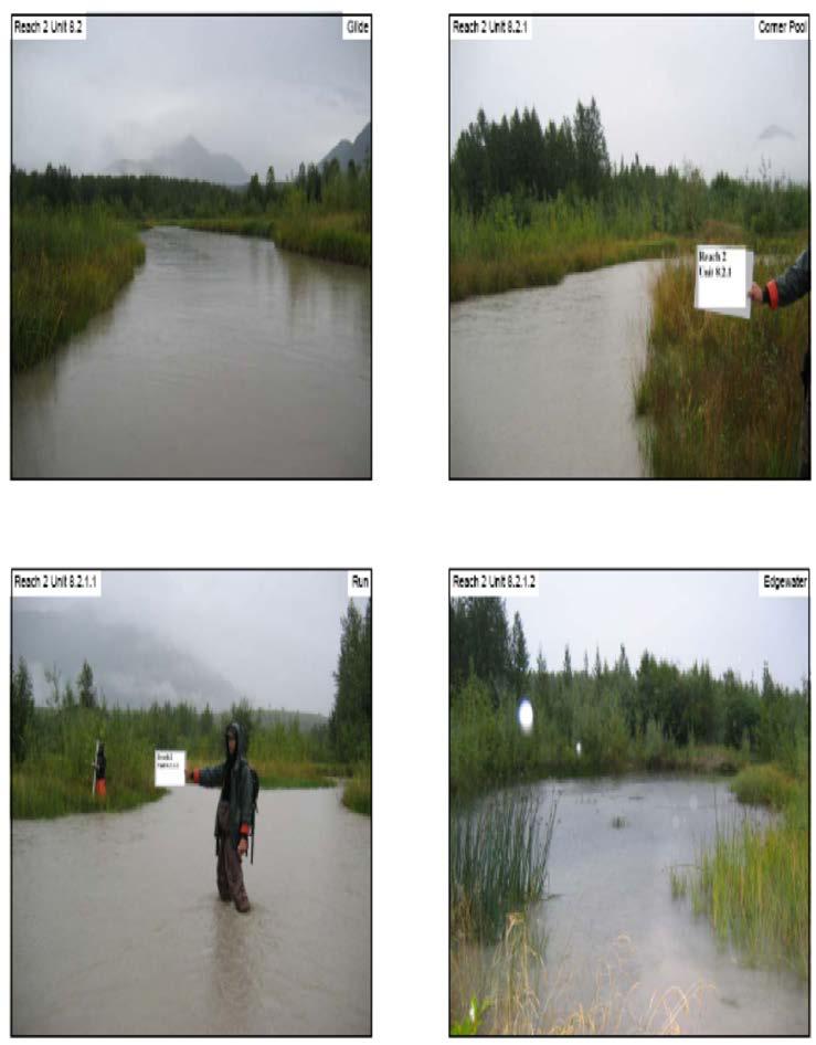
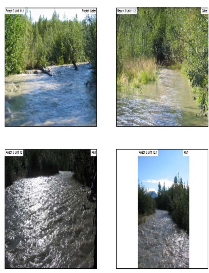
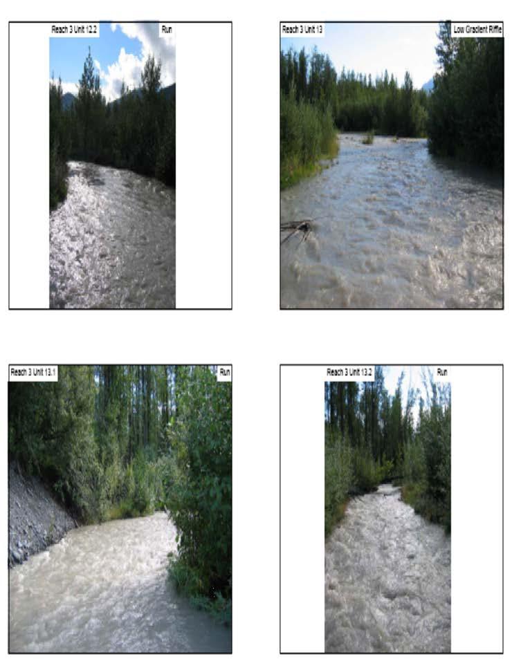
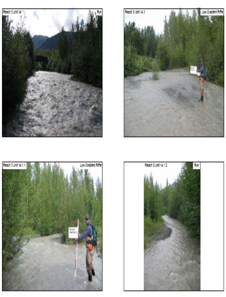
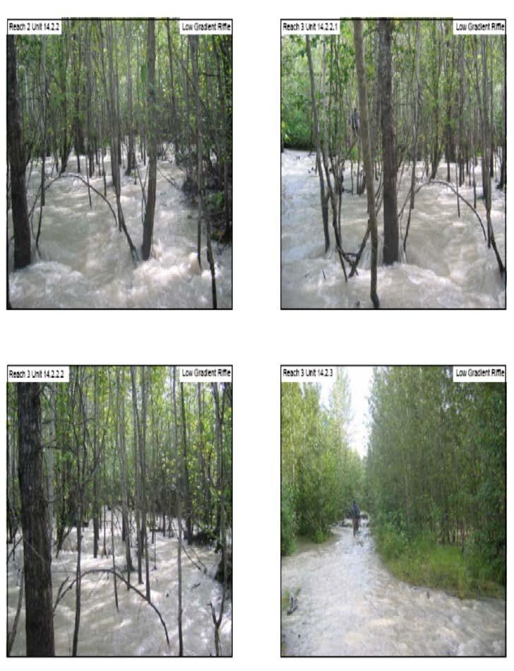
13 salmon (Figure 4). There are two (2) corner pools near the upper end of the reach with depths of feet both with cobble tail-outs. The residual depth of these pools range between 1.5 and 2.5 feet. This area has a main substrate of silt due to tidal influence and the low gradient. Table 3. Summary of Pool, Riffle, and Flatwater Habitat Types for Reach 2 Habitat Types Habita t Units Habitat % Occurrenc e Total Lengt h (ft) Mean Lengt h (ft) Mean Widt h (ft) Mean Dept h (ft) Mean Max Dept h (ft)* Mean Dept h Pool Tail Crest (ft) Mean Area (ft)2 Total Area (ft)2 Mean of Averag e Mean Residua l Pool Depth (ft) Glide 6 22% 1, N/A N/A 7,703 46,220 N/A 0 Run 3 26% N/A N/A 18, ,240 N/A 0 Edgewater 2 50% N/A N/A 53, ,800 N/A 0 Corner pool 2 2% ,800 3, Total % 3, ,860 *Max Depth, Pool Tail Crest Depth, and Residual Depth are only for pool habitats Mean Shelte r Rating Figure 5. Reach 2 Unit typical glide area showing dominate bank vegetation of grass. Reach 3 Reach 3 measures 8,154 feet including the length of all side channels, covering an area of 250,615 ft 2 and extending from the area of highest tidal reach to just above the new Glenn Highway Bridge (Figure 2 and 3). The boundaries of this reach were determined based on the substrate changes from the previous reach and the change to a defined bank system in the reach following. This reach is made up of mostly low gradient riffles, May Habitat Assessment of the Lower Eklutna River


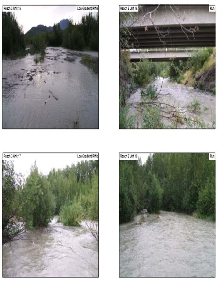
14 Habitat Type eleven (11), and runs, twelve (12), together contributing 91% of the area in this reach (Figure 5 and 6). The lower section of Reach 3 showed a mean instream shelter rating of 8 and the upper section a mean stream shelter rating of 29. During lower flows there are two main channels through this reach. During high flow events the channel quickly moves within the bankless flood plain into the forested area. The dominant substrate in this reach is cobble. The cobble becomes more embedded in the upper portion of this reach. The upper portion of this reach is forested with unstable channels. The lower portion presents more stable channels. Reach 3 is dominated by a cobble bank substrate and a dominant bank vegetation of deciduous trees and grass each comprising nearly 50% of the vegetation. This reach has no pools. Table 4. Summary of Pool, Riffle, and Flatwater Habitat Types for Reach 3 Habitat Units Habitat % Occurr ence Total Length (ft) Mean Length (ft) Mean Width (ft) Mean Depth (ft) Mean Max Depth (ft)* Mean Depth Pool Tail Crest (ft) Mean Area (ft)2 Total Area (ft)2 Mean of Average Mean Residual Depth (ft) Run 12 44% N/A N/A N/A 19 Low Grade Riffle 11 41% N/A N/A N/A 58 Glide 2 7% N/A N/A N/A 0 Corner pool 1 4% Pocket Water 1 4% N/A N/A N/A 15 Total % *Max Depth, Pool Tail Crest Depth, and Residual Depth are only for pool habitats Mean Shelter Rating Figure 6. Lower Reach 3 Unit 11 Figure 7. Upper Reach 3 Unit area showing grass bank low gradient riffle flowing composition. through thick cover. May Habitat Assessment of the Lower Eklutna River
 glides, four (4) low gradient riffles, and five (5) runs. They represent 41%, 31% and 27% of the area in this reach respectively.")
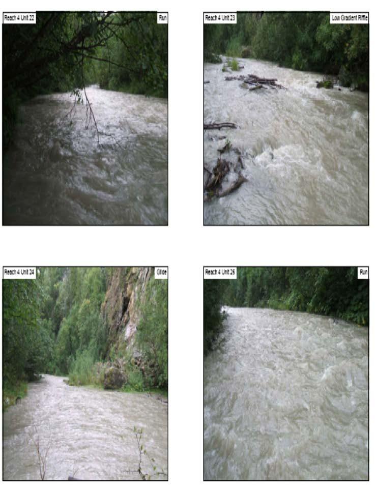
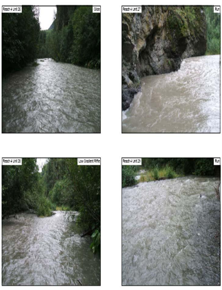
15 Reach 4 Reach 4 measures 2,625 feet, covering an area of 118,150 ft 2 from just above the New Glenn Highway Bridge to the confluence of Thunderbird Creek (Figure 2). It is a single channel that is characterized by two (2) glides, four (4) low gradient riffles, and five (5) runs. They represent 41%, 31% and 27% of the area in this reach respectively. Instream shelter ratings for this reach ranged from The mean instream shelter rating for flatwater is 13. This area has a well defined bank with no pools. The reach now contains little area for adult fish to hold up and rest during high flows or to provide rearing habitat. The reach is dominantly vegetated by deciduous trees and a large supply of boulders from rockslides (Figure 7). This reach has no pools. Table 5. Summary of Pool, Riffle, and Flatwater Habitat Types for Reach 4 Habitat Type Habitat Units Habitat % Occurrence Total Length (ft) Mean Length (ft) Mean Width (ft) Mean Depth (ft) Mean Max Depth (ft)* Mean Depth Pool Tail Crest (ft) Mean Area (ft)2 Total Area (ft)2 Mean of Averages Mean Residual Depth (ft) Mean Shelter Rating Run 5 45% N/A N/A N/A 9 Low Grade Riffle 4 36% N/A N/A N/A 25 Glide 2 18% N/A N/A N/A 22 Total % *Max Depth, Pool Tail Crest Depth, and Residual Depth are only for pool habitats Figure 8. Reach 4 Unit 24 a typical glide area with boulders and a dominate bank vegetation of deciduous trees. May Habitat Assessment of the Lower Eklutna River
 pools. Both pools were immeasurable for characteristics because of stream depth and current velocities in the two (2) pool habitat units.")
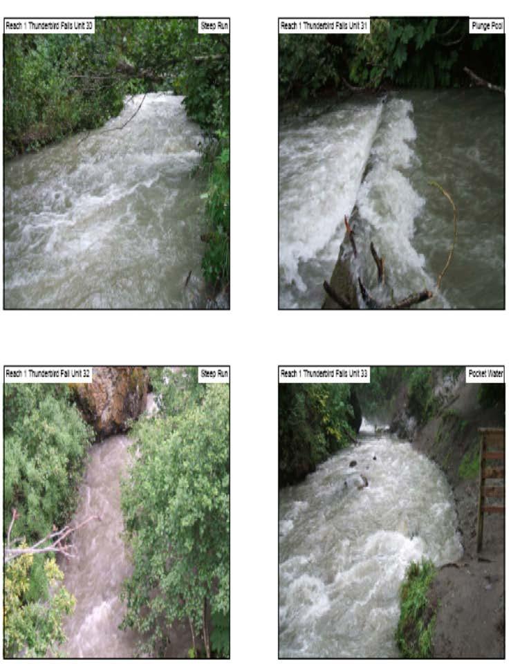
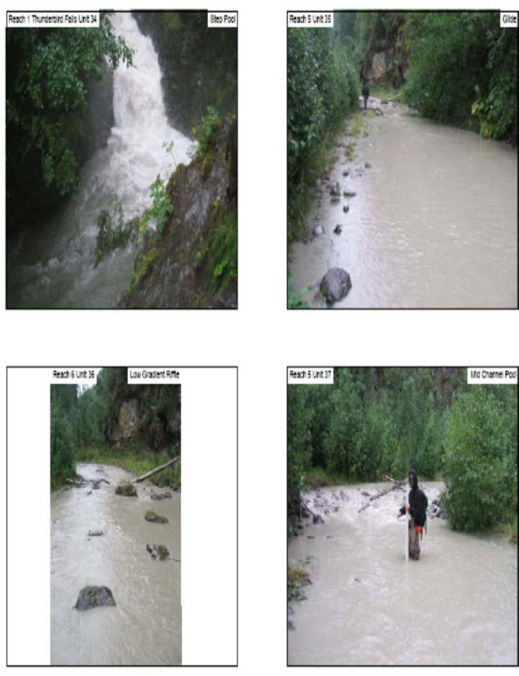
16 Thunderbird Creek Reach 1 Thunderbird Creek Reach 1, starts at the confluence with Eklutna River and extends to the waterfall, measuring 1,080 feet, covering an area of 37,700 ft 2 (Figure 2). This reach is a single steep run, 71% by area, with two (2) pools. Both pools were immeasurable for characteristics because of stream depth and current velocities in the two (2) pool habitat units. Mean instream shelter ranges from 0-30 in this reach. Banks are composed of cobble and are vegetated with deciduous trees (Figure 8). The channel has a moderate gradient with a dominant substrate of cobble and ends with an impassible waterfall that forms a plunge pool. No residual pool depths were calculated based on the inability to measure pool tail crest depth of the two (2) pools within this reach. Table 6. Summary of Pool, Riffle, and Flatwater Habitat Types for Reach 1 Thunderbird Creek Habitat Type Habitat Units Habitat % Occurrence Total Length (ft) Mean Length (ft) Mean Width (ft) Mean Depth (ft) Mean Max Depth (ft)* Mean Depth Pool Tail Crest (ft) Mean Area (ft)2 Total Area (ft)2 Mean of Averages Mean Residual Depth (ft) Steep Run 2 40% N/A N/A N/A 13 Pocket Water 1 20% N/A N/A N/A 30 Step Pool 1 20% N/A N/A N/A N/A 0 Plunge Pool 1 20% N/A N/A 25 Total 5 100% *Max Depth, Pool Tail Crest Depth, and Residual Depth are only for pool habitats Mean Shelter Rating Figure 9. Thunderbird Creek Reach 1 Unit 32 overhead view of a step run area with a dominate bank vegetation of deciduous trees. May Habitat Assessment of the Lower Eklutna River
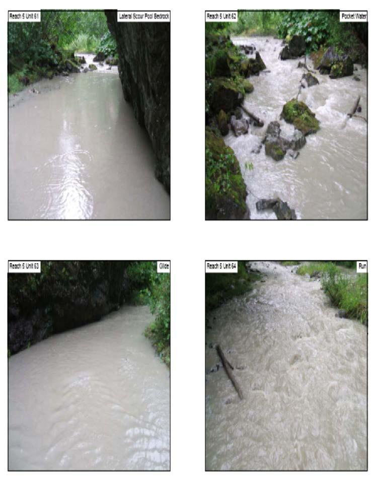
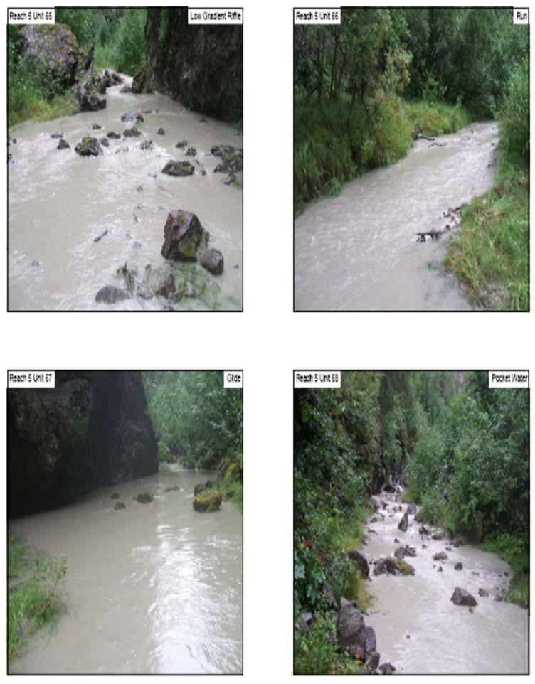
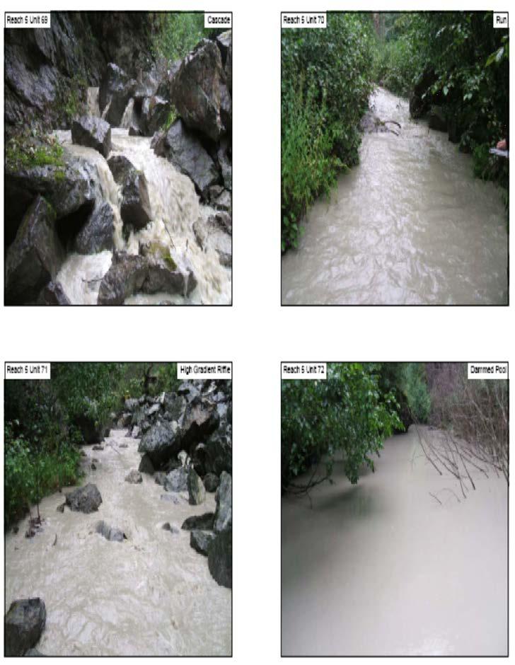
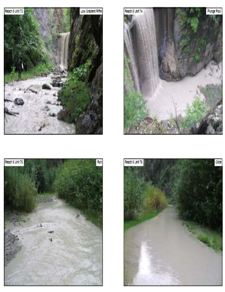
17 Reach 5 Reach 5 measures 5,532 feet, covering an area of 145,430 ft 2 from the confluence with Thunderbird Creek to the Lower Eklutna Dam (Figure 2). Reach 5 is a low gradient meandering channel containing the largest complexity of habitat types within the survey area. This reach is dominated by low gradient riffles, fourteen (14), and runs, seven (7), by area, 26% and 32% respectively. The mean instream shelter rating for this reach ranges from Pools compose 25% of the reach by area. Six of the nine pools were 2-3 feet deep. The residual depth of the nine pools averaged 2 feet deep for measurable pools within this reach. Four pools contained a dominate tail-out of silt/sand and three pools contained tail-outs of cobble/gravel. The reach is dominantly vegetated by deciduous trees with banks composed of cobble (Figure 9). Table 7. Summary of Pool, Riffle, and Flatwater Habitat Types for Reach 5 Habitat Type Habit at Units Habitat % Occurren ce Total Leng th (ft) Mean Leng th (ft) Mea n Widt h (ft) Mea n Dept h (ft) Mea n Max Dept h (ft)* Mea n Dept h Pool Tail Cres t (ft) Mea n Area (ft)2 Total Area (ft)2 Mean of Averag es Mean Residu al Depth (ft) Low Grade Riffle 14 35% N/A N/A N/A 6 Run 7 18% N/A N/A N/A 15 Glide 6 15% N/A N/A N/A 12 Lateral Scour Bedrock Pool 6 15% Pocket Water 2 5% N/A N/A N/A 8 Plunge Pool 1 3% N/A N/A N/A N/A 0 Midchannel Pool 1 3% Dammed Pool 1 3% N/A N/A 45 Cascade 1 3% N/A N/A N/A 20 High Grade Riffle 1 3% N/A N/A N/A 10 Total % 4732 *Max Depth, Pool Tail Crest Depth, and Residual Depth are only for pool habitats Mean Shelt er Ratin g May Habitat Assessment of the Lower Eklutna River
 habitat units for a total of 1,782 feet, covering an area of 20,120 ft 2 above the Lower Eklutna Dam. The dam blocks all fish passage (Figure 2).")
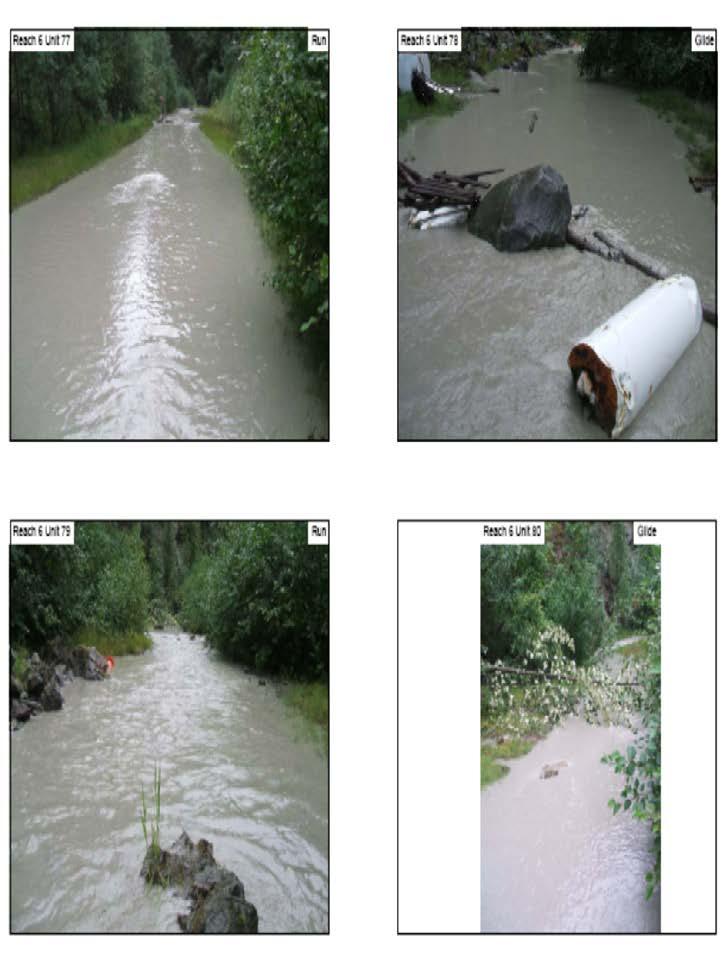
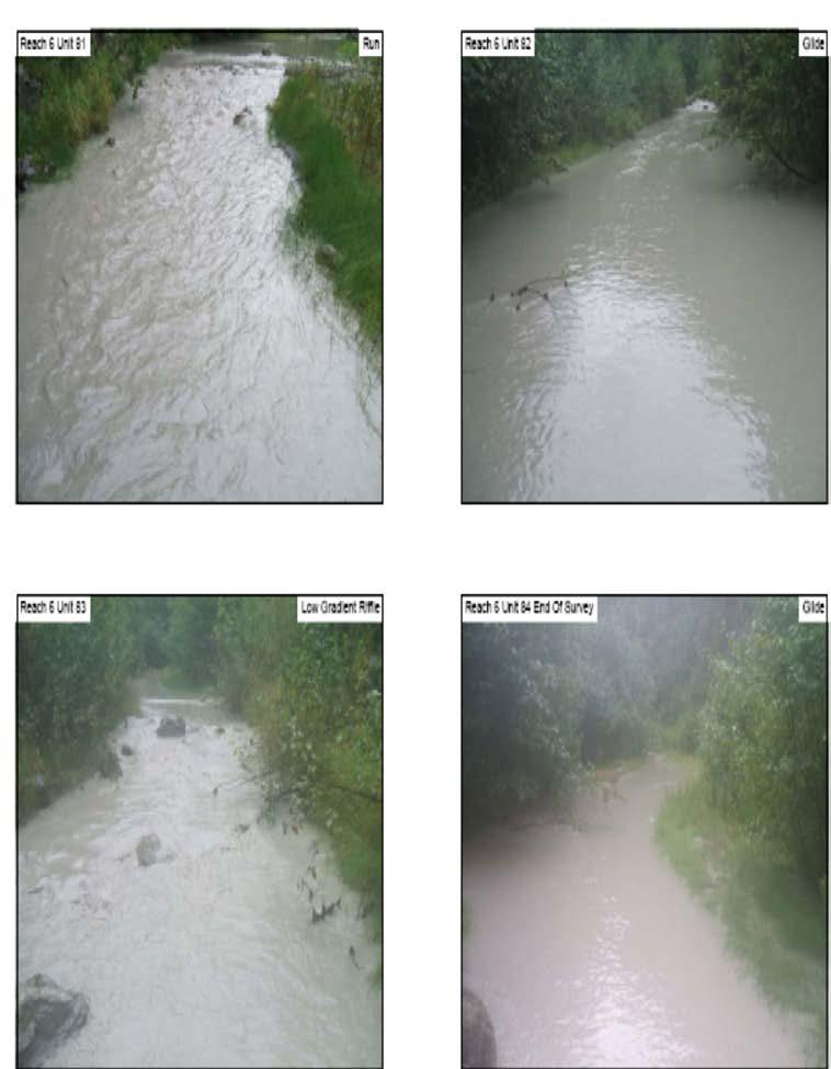
18 Figure 10. Reach 5 Unit 42 typical run showing a large cobble substrate with deciduous trees and grass dominated banks. Reach 6 Reach 6 extends ten (10) habitat units for a total of 1,782 feet, covering an area of 20,120 ft 2 above the Lower Eklutna Dam. The dam blocks all fish passage (Figure 2). Suggested stream surveys of the remainder of Reach 6 and up to Eklutna Lake are discussed in the recommendations. This reach is a meandering channel made up of five (5) runs, and four (4) glides, 50% and 47% by area respectively, with dominant substrates of cobble and sand (Figure 10). Mean instream shelter ratings for this reach range from 3-7. This reach has no pools. Table 8. Summary of Pool, Riffle, and Flatwater Habitat Types for Reach 6 Habitat Type Habit at Units Habitat % Occurren ce Total Lengt h (ft) Mean Lengt h (ft) Mea n Widt h (ft) Mea n Dept h (ft) Mea n Max Dept h (ft)* Mea n Dept h Pool Tail Cres t (ft) Mea n Area (ft)2 Total Area (ft)2 Mean of Average s Mean Residu al Depth (ft) Mean Shelt er Ratin g Glide 5 50% N/A N/A N/A 7 Run 4 40% N/A N/A N/A 3 Low Grade Riffle 1 10% N/A N/A N/A 5 Total % *Max Depth, Pool Tail Crest Depth, and Residual Depth are only for pool habitats May Habitat Assessment of the Lower Eklutna River

19 Figure 11. Reach 6 Unit 77 typical run showing grass and deciduous tree bank vegetation. Flow Flow for the study period ranged from 97 cfs to 240 cfs. This data was collected from the stage gauge located at the Old Glenn Highway Bridge. This represented the highest flows recorded since the installation of the stage gauge in May of Average flows from are about 45 cfs for this time period. Data collected for this report defines habitat characteristics present during the survey. These characteristics change with differences in flow. As a result, photos, past assessments and the knowledge of the NVE Land and Environment Director, Marc Lamoreoux must be considered to understand conditions of the river at varied flows. A benefit of sampling during an unusually high flow event is that it permitted collection of data on conditions that restoration improvements could be engineered to withstand. These characteristics are considered in the recommendations section of this document. Temperature The air temperature during the survey period was degrees Celsius. The water temperature for the survey period was 7 degrees Celsius. BIOLOGICAL INVENTORY RESULTS The biological inventory included the following observations; May Habitat Assessment of the Lower Eklutna River
20 Reach 1 Reach 2 Reach 3 Reach 4 Reach 1 Thunderbird Creek Reach 5 1 dead King, 1 dead Sockeye, 1 dead beaver 4 live Chum, 2 live Pink, One 8ft X 12ft beaver lodge 6 live Chum, 3 live Pinks 2 live Pink, 12 dead Pink, signs of bear None 1 Dolly Varden, one 12ft X 20ft beaver lodge, signs of bear, 1 dead moose near dam NVE has conducted fish counts for the years of 2002 thru 2003 and a summary abstract of that data is located in Attachment B. RECOMMENDATIONS Recommendations are provided for improvement of salmon habitat in Eklutna River by reach. The sustainability of salmon populations depends on proper habitat. The adult and juvenile life stages of each salmon species require unique conditions. Channel types are used to define these unique conditions. The CSSHRM produces broad recommendations for all five species as a whole for 41 different channel types, and states; Although the process of habitat evaluation and basic restoration techniques are generally similar for California salmonids, their habitat preferences are frequently dissimilar. Therefore, applications must be selected that are suitable for the specific target species and life stage (xvii). The channel types defined in this habitat assessment are based on high flow and are not representative of the river at normal flows. Flow observed during the survey provided valuable information for the design of restoration when used with previous photos and habitat assessments conducted at lower flows. The Native American Fish and Wildlife Society offered trainings 3 times a year for four years to prepare tribal staff to conduct physical habitat assessments; although no official report was published the tribe owns these data in addition to photos which span the last 6 years. In combination these data provide sufficient information to design habitat restoration structures based on the current flow regime featuring zero flow from the lake and draining a 55 square mile watershed. The restoration techniques provided by the CSSHRM are provided in Part 7 of the manual which is included in Attachment A. For areas that a mean instream shelter rating of less than 80 was calculated it is recommended by the CSSHRM that shelter is added to the reach. This value was considered when the addition of rock and woody debris is suggested in the following recommendations. Reach 1 has large tidal range, silt substrate and would not be conducive to any habitat restoration due to its dynamic nature. This reach provides fish passage for incoming adult and outgoing juvenile salmon. Restoration for Reach 2 and the lower portions of Reach 3 can be discussed together based on the similarities of the reaches. This area extends from the lower ponds to above May Habitat Assessment of the Lower Eklutna River
21 the railroad bridge at habitat units and This area is suitable for spawning improvements for chum, pink, coho, and king that could include the installation of large woody debris or rock structures to facilitate the development of more pools and productive spawning habitat. Rearing improvements for king and coho would require the enhancement of over wintering habitat for the juvenile life stages. Deep ponds could be designed to support over wintering and provide sufficient aquatic and bank vegetation for summer rearing coho and king. Improvements could be engineered by connecting the river to the existing ponds, man made ponds, or instream ponds. Engineered instream pools could be placed in areas of natural upwelling to help maintain open water areas during the winter. The lower ponds of Reach 2, just above dominant tidal influence, are presently providing summer rearing habitat. As these ponds mature, rearing habitat will improve until the point that the pond has filled. Currently, the upper reaches of the ponds have developed successful macrophytic populations which provide excellent shelter and feeding habitat. While these ponds could be improved by increased shelter value and improved bank vegetation, dredging is not recommended. Prior site assessment by the Natural Resource Conservation Service, State Biologist Bill Wood, has identified dredging as an option to improve rearing and overwintering habitat. However, dredging would require transport and disposal of silt. The area is actively influenced by tidal events and is filling with tidal and river sediment. Due to this instability, habitat improvements are not recommended because they are not likely to provide measurable benefits before they would need to be dredged again. Further, the habitat that would be impacted to improve the ponds is functional summer rearing habitat for coho and king salmon that is otherwise limited in the system. Recommendations are not made for the upper portion of Reach 3 because of unstable channels. These channels consist of constantly changing banks and to ensure the success of restoration efforts channelization would be required. This is not recommended because the area currently provides summer rearing habitat for coho and king. The existing habitat has excellent shelter from predators and provides a significant contribution of forest debris contributing to productive feeding habitat. Reach 4 and Reach 1 of Thunderbird Creek are long straight stretches of the river with a small amount of holding habitat for adult salmon. Spawning and rearing improvements in this area for chum, pink, coho, and king could include the installation of large woody debris and rock structures to create pools. Reach 5 features more complex habitat structures that already include a large amount of woody debris and a large number of pools. The Lower Eklutna Dam has depleted this area of much needed gravel leaving some areas with a bedrock surface. Gravel substrate is needed to support rearing and spawning salmon in this reach. Gravel is available behind the Lower Eklutna Dam. To transport the substrate the dam could be notched and an increased flow from the lake or other sources could be added to flush gravel to areas below the dam. Charles F. Cobb, the State of Alaska Dam Safety Engineer, looked at the safety of removing the dam and determined it safe to remove or leave the Lower Eklutna May Habitat Assessment of the Lower Eklutna River
22 Dam in its present state. This adaptive management technique could be employed and monitored over time. Any negative impacts from the notching could be mitigated by sealing the notch after redirecting the minor amount of flow involved. Notching will concentrate the hydraulic force to better transport larger particles downstream. Further, notching could be accomplished incrementally to minimize the potential of any dramatic changes. An increase of flow to this area could also help with the flushing of fines that have degraded the little available substrate within this reach. Reach 6 begins at the 68 ft tall Lower Eklutna Dam. The dam prevents salmon passage and is filled with substrate. Removal of the Lower Eklutna Dam and release of flows from Eklutna Lake sufficient to transport substrate to a gradient that permits salmon passage would allow for anadromous salmon to access this reach. The constraints of the canyon and the reduced flow make a bypass channel or fish ladder not a feasible means of allowing fish to pass this barrier. The survey area in the assessment had mean shelter ratings below the level of 80 which the CSSHRM determined to be the lower limit in determining areas that would benefit from added shelter. This level is used in California in areas where shelter can provide water cooling benefits through shade areas. This value should be lower for Alaska based on the fact that temperatures are not usually a limiting factor for a salmon stream. Shelter is still needed for cover from predation for both adults and juveniles. Actual shelter throughout the survey could be increased with the addition of large woody debris and rock structures as talked about in the reach discussion above. Recommendations for further research to improve salmon habitat in the Eklutna River include; Assessment of fisheries habitat potential presented by removal of the Lower Eklutna Dam and subsequent return of some flows from Eklutna Lake. Author and implement design for installing habitat restoration structures in habitat deficient Reaches 2-5 and Reach 1 of Thunderbird Creek using available materials and following part 7 of the CSSHRM Investigation of groundwater table in Reaches 2 and 3 to support pond design (Figure 3) Design ponds and/or instream pools to support king and coho rearing and overwintering habitat May Habitat Assessment of the Lower Eklutna River
23 REFERENCES Flosi, G., Downie, S., Hopelain, J., Bird, M., Coey, R., and Collins, B California Salmonid Stream Habitat Restoration Manual, 3rd edition. California Department of Fish and Game, Sacramento, California. McCain, M., D. Fuller, L. Decker and K. Overton Stream habitat classification and inventory procedures for northern California. FHC Currents. No.1. U.S. Department of Agriculture. Forest Service, Pacific Southwest Region. Rosgen, D.L., A Classification of Natural Rivers. Catena, Vol 22: , Elsevier Science, B. V. Amsterdam. May Habitat Assessment of the Lower Eklutna River
24 Attachments May Habitat Assessment of the Lower Eklutna River
25 Attachment A 1. PowerPoint Presentation of results provided December 8, Photolog 3. California Salmonid Stream Habitat Restoration Manual 4. Raw Data 5. Electronic files of this report Attachment B Attachment C Attachment D 1. Data Collection Sheets 2. Data Collection Equipment 3. Level IV Habitat Types 4. Shelter Values 1. Aerial Map of Lower Eklutna System 2. Reach Summary 3. Charts 4. Summary of NVE Fish Counts 1. Photolog 2. Channel Delineation Forms 3. Habitat Inventory Forms 4. Field Drawings May Habitat Assessment of the Lower Eklutna River
26 Attachment A A1. PowerPoint Presentation of results December 8, 2006 A2. Photolog A3. CSSHRM A4. Raw Data A5. Electronic files of this report May Habitat Assessment of the Lower Eklutna River
27 Attachment B B1. Data Collection Sheets May Habitat Assessment of the Lower Eklutna River
28 May Habitat Assessment of the Lower Eklutna River

29 May Habitat Assessment of the Lower Eklutna River
30 Attachment B B2. Data Collection Equipment May Habitat Assessment of the Lower Eklutna River
31 Data Collection Equipment Stream Channel Work Sheet Habitat Inventory Data Forms Pencils Plastic Flagging Topographic and Aerial Maps Digital Camera Thermometer Stopwatch Stadia Rod Fiberglass open reel tape 200 feet Flow Meter Hand Level Compass Hip chain and thread GPS May Habitat Assessment of the Lower Eklutna River
32 Attachment B B3. Level IV Habitat Types May Habitat Assessment of the Lower Eklutna River
33 LEVEL IV HABITAT TYPES RIFFLE Low Gradient Riffle (LGR) [1.1] { 1} High Gradient Riffle (HGR) [1.2] { 2} CASCADE Cascade (CAS) [2.1] { 3} Bedrock Sheet (BRS) [2.2] {24} FLATWATER Pocket Water (POW) [3.1] {21} Glide (GLD) [3.2] {14} Run (RUN) [3.3] {15} Step Run (SRN) [3.4] {16} Edgewater (EDW) [3.5] {18} MAIN CHANNEL POOLS Trench Pool (TRP) [4.1] { 8 } Mid-Channel Pool (MCP) [4.2] {17} Channel Confluence Pool (CCP) [4.3] {19} Step Pool (STP) [4.4] {23} SCOUR POOLS Corner Pool (CRP) [5.1] {22} Lateral Scour Pool - Log Enhanced (LSL) [5.2] {10} Lateral Scour Pool - Root Wad Enhanced (LSR) [5.3] {11} Lateral Scour Pool - Bedrock Formed (LSBk) [5.4] {12} Lateral Scour Pool - Boulder Formed (LSBo) [5.5] {20} Plunge Pool (PLP) [5.6] { 9 } BACKWATER POOLS Secondary Channel Pool (SCP) [6.1] { 4 } Backwater Pool - Boulder Formed (BPB) [6.2] { 5 } Backwater Pool - Root Wad Formed (BPR) [6.3] { 6 } Backwater Pool - Log Formed (BPL) [6.4] { 7 } Dammed Pool (DPL) [6.5] {13} ADDITIONAL UNIT DESIGNATIONS Dry (DRY) [7.0] Culvert (CUL) [8.0] Not Surveyed (NS) [9.0] Not Surveyed due to a marsh (MAR) [9.1] May Habitat Assessment of the Lower Eklutna River
34 Attachment B B4. Shelter Values May Habitat Assessment of the Lower Eklutna River
35 Instream Shelter Complexity Values Value of 0 No shelter Value of 1 One to five boulders Bare undercut bank or bedrock ledge Single piece of large wood (>12" diameter and 6' long) defined as large woody debris (LWD) Value of 2 One or two pieces of LWD associated with any amount of small wood (<12" diameter) defined as small woody debris (SWD) Six or more boulders per 50 feet Stable undercut bank with root mass, and less than 12" undercut A single root wad lacking complexity Branches in or near the water Limited submersed vegetative fish cover Bubble curtain Value of 3 Combinations of (must have at least two cover types): LWD/boulders/root wads Three or more pieces of LWD combined with SWD Three or more boulders combined with LWD/SWD Bubble curtain combined with LWD or boulders Stable undercut bank with greater than 12" undercut, associated with root mass or LWD Extensive submersed vegetative fish cover May Habitat Assessment of the Lower Eklutna River
36 Attachment C C1. Aerial Photograph of Lower Eklutna River System May Habitat Assessment of the Lower Eklutna River
37 Figure 12. Aerial Photograph of the Lower Eklutna River System
38 Attachment C C2. Reach Summary May Habitat Assessment of the Lower Eklutna River
39 Reach Summary Stream Name: Eklutna River/Thunderbird Creek Sample Date: August 21-24, 2006 Stream Length: ft Eklutna River/ 1080 ft Thunderbird Creek Stream Area: ft 2 Eklutna River/ ft 2 Thunderbird Creek Location of Mouth Eklutna: Latitude N Longitude W /-9ft Location of Mouth Thunderbird Creek: Latitude N Longitude W /-26ft Summary by Reach Reach 1 Channel Type: F6 Description: Entrenched meandering riffle/pool channel on low gradient with high width depth ratio; silt/clay channel. Single or Braided Reach: Single Channel Length: 3720ft (15%total river length) Mean Width: 48.2ft Area of Reach: ft 2 (20% total river area) Min/max mean depth of riffles: 1.8ft/3ft Max and Average depth of pools: 0/0 Number of Pools: 0 Dominate Bank Composition: Silt Dominate Bank Vegetation: None Dominate Substrates: Silt/Gravel Dominate Shelter: None Average Canopy Cover per Unit: 0% Fish Seen Within Reach: King Salmon, Sockeye both dead on bank Reach 2 Channel Type: DA6 Description: Multiple channels, narrow and deep with expansive well vegetated floodplain and associated wetlands; very gentle relief with high variable sinuosities; stable stream banks; silt/clay channel. Single of Braided Reach: Braided Channel Length: 3496ft includes all side braids (14% total river length) Mean Width: Area of Reach: ft 2 (23% total river area) Min/max mean depth of riffles: 1ft/3.1ft Max and Average depth of pools: 4.5ft/4.25ft Number of Pools: 2 Dominate Bank Composition: Silt Dominate Bank Vegetation: Grass Dominate Substrates: Silt/Sand Dominate Shelter: Terrestrial Vegetation Average Canopy Cover per Unit: 1.5% Fish Seen Within Reach: Chum Salmon, Pink Salmon May Habitat Assessment of the Lower Eklutna River
40 Reach 3 Channel Type: D3 Description: Multiple channels with longitudinal and transverse bars; very wide channel with eroding banks; cobble channel. Single or Braided Reach: Braided Channel Length: 8154ft includes all side braids (32% total river length) Mean Width: 32.11ft Area of Reach: ft 2 (27% total river area) Min/max mean depth of riffles: 0.7ft/5ft Max and Average depth of pools: 4ft/4ft Number of Pools: 1 Dominate Bank Composition: Cobble/Gravel Dominate Bank Vegetation: Deciduous Trees Dominate Substrate: Gravel/Small Cobble Dominate Shelter: Small Woody Debris Average Canopy Cover per Unit: 42% Fish Seen Within Reach: Pink Salmon, Chum Salmon Reach 4 Channel Type: C3 Description: Low gradient, meandering, point-bar, riffle/pool alluvial channels with broad, well defined floodplain, cobble channel. Single or Braided Reach: Single Channel Length: 2625ft (10% total river length) Mean Width: 43.64ft Area of Reach: ft 2 (13% total river area) Min/max mean depth of riffles: 1.5ft/2.5ft Max and Average depth of pools: 0/0 Number of Pools: 0 Dominate Bank Composition: Cobble/Gravel Dominate Bank Vegetation: Grass Dominate Substrates: Small Cobble/Large Cobble Dominate Shelter: Small Woody Debris Average Canopy Cover per Unit: 34% Fish Seen Within Reach: Pink Salmon May Habitat Assessment of the Lower Eklutna River
41 Reach 1 Thunderbird Creek Channel Type: B3 Description: Moderately entrenched, moderate gradient, riffle dominated channel with infrequently spaced pools; very stable plan and profile; stable banks; cobble channel. Single or Braided Reach: Single Channel Length: 1080ft Mean Width: 39ft Area of Reach: ft 2 Min/max mean depth of riffles: 2.2ft/2.5ft Max and Average depth of pools: 3ft/3ft one pool immeasurable Number of Pools: 2 Dominate Bank Composition: Cobble/Gravel Dominate Bank Vegetation: Deciduous Trees Dominate Substrates: Small Cobble/Large Cobble Dominate Shelter: Terrestrial Vegetation Average Canopy Cover per Unit: 55% Fish Seen Within Reach: None Reach 5 Channel Type: F6 Description: Entrenched meandering riffle/pool channel on low gradient with high width depth ratio; silt/clay channel. Single or Braided Reach: Single Channel Length: 5532ft (22% total river length) Mean Width: 24.75ft Area of Reach: ft 2 (16% total river area) Min/max mean depth of riffles: 0.4ft/4ft Max and Average depth of pools: 4.6ft/2.8ft Number of Pools: 7 Dominate Bank Composition: Cobble/Gravel Dominate Bank Vegetation: Grass Dominate Substrates: Silt/Large Cobble Dominate Shelter: Terrestrial Vegetation/Large Woody Debris Average Canopy Cover per Unit: 35% Fish Seen Within Reach: Dolly Varden May Habitat Assessment of the Lower Eklutna River
42 Reach 6 Channel Type: E5 Description: Low gradient, meandering riffle/pool stream with low width/depth ratio and little deposition; very efficient and stable; high meander width ratio; sand channel. Single or Braided Reach: Single Channel Length: 1782 (7% total river length) Mean Width: 12.6 Area of Reach: ft 2 (2% total river area) Min/max mean depth of riffles: 1ft/2.2ft Max and Average depth of pools: 0/0 Number of Pools: 0 Dominate Bank Composition: Cobble/Gravel Dominate Bank Vegetation: Grass Dominate Substrates: Small Cobble/Sand Dominate Shelter: Terrestrial Vegetation Average Canopy Cover per Unit: 18% Fish Seen Within Reach: None May Habitat Assessment of the Lower Eklutna River
43 Attachment C C3. Charts May Habitat Assessment of the Lower Eklutna River
44 Chart Eklutna River Habitat Assessment Percentage by Total Length of Habitat Level IV Classifications Eklutna Drainage Reach 6 Reach 5 Reach 1 Thunderbird Creek Reach 4 Reach 3 Reach 2 Glide Run Pocket water Edgewater Steep run Low grade riffle High grade riffle Cascade Corner pool Lateral scour pool bedrock Plunge pool Step pool Mid-channel pool Dammed pool Reach 1 0% 20% 40% 60% 80% 100% Percentage
45 Chart Eklutna River Habitat Assessment Percentage by Total Length of Habitat Level II Classification Eklutna Drainage Reach 6 Reach 5 Reach 1 Thunderbird Creek Reach 4 Riffle Flatwater Pool Reach 3 Reach 2 Reach 1 0% 20% 40% 60% 80% 100% Percentage
46 Chart Eklutna River Habitat Assessment Percentage by Occurrence of Habitat Level IV Classifications Eklutna Drainage Reach 6 Reach 5 Reach 1 Thunderbird Creek Reach 4 Reach 3 Reach 2 Glide Run Pocket water Edgewater Steep run Low grade riffle High grade riffle Cascade Corner pool Lateral scour pool bedrock Plunge pool Step pool Mid-channel pool Dammed pool Reach 1 0% 20% 40% 60% 80% 100% Percentage
47 Chart Eklutna River Habitat Assessment Percentage by Occurrence of Habitat Level II Classification Eklutna Drainage Reach 6 Reach 5 Reach 1 Thunderbird Creek Reach 4 Riffle Flatwater Pool Reach 3 Reach 2 Reach 1 0% 20% 40% 60% 80% 100% Percentage
48 Chart Eklutna River Habitat Assessment Percentage by Area of Habitat Level IV Classification Eklutna Drainage Reach 6 Reach 5 Reach 1 Thunderbird Creek Reach 4 Reach 3 Reach 2 Glide Run Pocket water Edgewater Steep run Low grade riffle High grade riffle Cascade Corner pool Lateral scour pool bedrock Plunge pool Step pool Mid-channel pool Dammed pool Reach 1 0% 10% 20% 30% 40% 50% 60% 70% 80% 90% 100% Percentage
49 Chart Eklutna River Habitt Assessment Perentage by Area of Habitat Level II Classification Eklutna Drainage Reach 6 Reach 5 Reach 1 Thunderbird Creek Reach 4 Riffle Flatwater Pool Reach 3 Reach 2 Reach 1 0% 10% 20% 30% 40% 50% 60% 70% 80% 90% 100% Percentage
50 Chart Eklutna River Habitat Assessment Pool Tail-out Composition Cobble/Gravel Sand/Silt Immeasurable Number of Pools Reach 1 Reach 2 Reach 3 Reach 4 Reach 1 Thunderbird Creek Reach Reach 5 Reach 6 Eklutna Drainage
51 Chart Eklutna River Habitat Assessment Pool Depths Per Reach >1 Foot 1>2 Feet 2>3 Feet 3>4 Feet 4>5 Feet Immeasurable Number of Pools Reach 1 Reach 2 Reach 3 Reach 4 Reach 1 Thunderbird Creek Reach Reach 5 Reach 6 Eklutna Drainage
52 Chart Eklutna River Habitat Assessment Dominate Bank Vegetation by Reach Eklutna Drainage Reach 6 Reach 5 Reach 1 Thunderbird Creek Reach 4 No Vegetation Grass Brush Deciduous Trees Reach 3 Reach 2 Reach 1 0% 20% 40% 60% 80% 100% Percentage
53 Chart Eklutna River Habitat Assessment Dominate Bank Composition by Reach Eklutna Drainage Reach 6 Reach 5 Reach 1 Thunderbird Creek Reach 4 Silt/Clay/Sand Cobble/Gravel Boulder Bedrock Reach 3 Reach 2 Reach 1 0% 20% 40% 60% 80% 100% Percentage
54 Attachment C C4. Summary of NVE Fish Counts May Habitat Assessment of the Lower Eklutna River
55 Summary of NVE Fish Counts From data collected by the Native Village of Eklutna for the years 2002 and 2003, the areas that salmon are currently using for spawning can be hypothesized. Reach 1 did not have any data because the fish counts started at the beginning of Reach 2. In Reach 2, fish are regularly seen in large numbers. Reach 2 is used as a holding area after the salmon have pushed up through the major tidal area of Reach 1 via Cook Inlet. In Reach 3 Chum salmon were the only salmon counted. Their numbers were very low and did not peak during any one time period. Reach 4 saw the largest numbers of king, coho, pink, and sockeye during daily counts in Reach 4 is mainly a straight stretch of river with little area for holding of fish or rearing. Reach 5 recorded the largest number of any type salmon at one time. In this reach chum salmon have numbered up to 500 at peak times during August. May Habitat Assessment of the Lower Eklutna River
56 Attachment D D1. Photolog May Habitat Assessment of the Lower Eklutna River
57
58
59
60
61
62
63
64
65
66
67
68
69
70
71
72
73
74
75

76

77
78
79
80
81
82
83
84
85 Attachment D D2. Stream Channel Delineation Forms May Habitat Assessment of the Lower Eklutna River
86 May Habitat Assessment of the Lower Eklutna System
87 May Habitat Assessment of the Lower Eklutna System
88 May Habitat Assessment of the Lower Eklutna System
89 May Habitat Assessment of the Lower Eklutna System
90 May Habitat Assessment of the Lower Eklutna System
91 May Habitat Assessment of the Lower Eklutna System
92 May Habitat Assessment of the Lower Eklutna System
93 Attachment D D3. Habitat Inventory Forms May Habitat Assessment of the Lower Eklutna System

94 May Habitat Assessment of the Lower Eklutna System

95 May Habitat Assessment of the Lower Eklutna System

96 May Habitat Assessment of the Lower Eklutna System

97 May Habitat Assessment of the Lower Eklutna System

98 May Habitat Assessment of the Lower Eklutna System

99 May Habitat Assessment of the Lower Eklutna System

100 May Habitat Assessment of the Lower Eklutna System
101 May Habitat Assessment of the Lower Eklutna System

102 May Habitat Assessment of the Lower Eklutna System
103 May Habitat Assessment of the Lower Eklutna System

104 May Habitat Assessment of the Lower Eklutna System

105 May Habitat Assessment of the Lower Eklutna System

106 May Habitat Assessment of the Lower Eklutna System

107 May Habitat Assessment of the Lower Eklutna System
108 Attachment D D4. Field Drawings May Habitat Assessment of the Lower Eklutna System

109 May Habitat Assessment of the Lower Eklutna System

110 May Habitat Assessment of the Lower Eklutna System

111 May Habitat Assessment of the Lower Eklutna System

112 May Habitat Assessment of the Lower Eklutna System

113 May Habitat Assessment of the Lower Eklutna System

114 May Habitat Assessment of the Lower Eklutna System

115 May Habitat Assessment of the Lower Eklutna System

116 May Habitat Assessment of the Lower Eklutna System

117 May Habitat Assessment of the Lower Eklutna System

118 May Habitat Assessment of the Lower Eklutna System

119 May Habitat Assessment of the Lower Eklutna System

120 May Habitat Assessment of the Lower Eklutna System

121 May Habitat Assessment of the Lower Eklutna System

122 May Habitat Assessment of the Lower Eklutna System

123 May Habitat Assessment of the Lower Eklutna System

124 May Habitat Assessment of the Lower Eklutna System

125 May Habitat Assessment of the Lower Eklutna System

126 May Habitat Assessment of the Lower Eklutna System

127 May Habitat Assessment of the Lower Eklutna System

128 May Habitat Assessment of the Lower Eklutna System

129 May Habitat Assessment of the Lower Eklutna System

130 May Habitat Assessment of the Lower Eklutna System

131 May Habitat Assessment of the Lower Eklutna System

132 May Habitat Assessment of the Lower Eklutna System

133 May Habitat Assessment of the Lower Eklutna System

134 May Habitat Assessment of the Lower Eklutna System
Rehabilitation of Grimes Creek, a Stream Impacted in the Past by Bucket-lined Dredge Gold Mining, Boise River Drainage, July 2008 to August 2011.
 Rehabilitation of Grimes Creek, a Stream Impacted in the Past by Bucket-lined Dredge Gold Mining, Boise River Drainage, July 2008 to August 2011. Pam Harrington TU,1020 W. Main Street Suite 440, Boise,
Hydraulic Modeling of Stream Enhancement Methods
 Hydraulic Modeling of Stream Enhancement Methods Matthew J. Curry John J. Levitsky Abstract Development within watersheds increases the amounts of runoff causing stream erosion and degradation of stream
Minnesota Department of Natural Resources Division of Fish and Wildlife Section of Fisheries. Stream Survey Report. Luxemburg Creek.
 Minnesota F-29-R(P)-24 Area 315 Study 3 March 2016 Minnesota Department of Natural Resources Division of Fish and Wildlife Section of Fisheries Stream Survey Report Luxemburg Creek 2015 Mark Pelham Sauk
Geomorphic Stream Classification A Classification of Natural Rivers, Rosgen, D.L.
 Geomorphic Stream Classification A Classification of Natural Rivers, Rosgen, D.L. Why is Stream Classification Physical stream channel evolution Essential? Similar stream types manifest similar patterns
Sub-watershed Summaries
 Project Description The Salmon Drift Creek Watershed Council (SDCWC) has focused their efforts in the Salmon River estuary for the past few years. The multifaceted partnership effort is nearing completion
Culvert Design for Low and High Gradient Streams in the Midwest. Dale Higgins, Hydrologist Chequamegon-Nicolet National Forest
 Culvert Design for Low and High Gradient Streams in the Midwest Dale Higgins, Hydrologist Chequamegon-Nicolet National Forest Overview Culvert Design Considerations Hydraulic Terms Culvert Impacts Low
Abundance of Steelhead and Coho Salmon in the Lagunitas Creek Drainage, Marin County, California
 scanned for KRIS Abundance of Steelhead and Coho Salmon in the Lagunitas Creek Drainage, Marin County, California Prepared for: Marin Municipal Water District 220 Nellen Drive Corte Madera, California
Study Update Tailrace Slough Use by Anadromous Salmonids
 Study Update Tailrace Slough Use by Anadromous Salmonids Goals and Objectives Identify what anadromous salmonids use the tailrace slough by: Life Stage (Juvenile, migrating and spawning adults) Timing
Assessment of Baseline Geomorphic Features at. Proposed Stream Crossings On The Proposed County Road 595. Marquette County, Michigan
 Assessment of Baseline Geomorphic Features at Proposed Stream Crossings On The Proposed County Road 595 Marquette County, Michigan Prepared for: Kennecott Eagle Minerals Company Marquette, Michigan Prepared
FISHERIES SURVEYS IN THE SOUTH FORK AMERICAN RIVER DOWNSTREAM OF SLAB CREEK DAM AND IOWA CANYON CREEK, 2010
 FISHERIES SURVEYS IN THE SOUTH FORK AMERICAN RIVER DOWNSTREAM OF SLAB CREEK DAM AND IOWA CANYON CREEK, 2010 Prepared for: Sacramento Municipal Utility District Power Generation Department 6201 S Street
Big Spring Creek Habitat Enhancement and Fishery Management Plans
 Big Spring Creek Habitat Enhancement and Fishery Management Plans November 5, 2012 Big Spring Events and Activities Center Newville, PA Charlie McGarrell Regional Habitat Biologist Pennsylvania Fish and
South Fork Chehalis Watershed Culvert Assessment
 South Fork Chehalis Watershed Culvert Assessment Water Resource Inventory Area 23 Lewis County Conservation District Final Report By: Kelly Verd and Nikki Wilson March 2003 Funded by: The Washington State
Newaukum Watershed Culvert Assessment
 Newaukum Watershed Culvert Assessment Water Resource Inventory Area 23 Lewis County Conservation District Final Report By: Kelly Verd and Nikki Wilson July 2002 Funded by: Chehalis Fisheries Restoration
Fish Migration Barrier Severity and Steelhead Habitat Quality in the Malibu Creek Watershed
 Fish Migration Barrier Severity and Steelhead Habitat Quality in the Malibu Creek Watershed Produced for California State Coastal Conservancy and California Department of Parks and Recreation By: Heal
3. The qualification raised by the ISRP is addressed in #2 above and in the work area submittal and review by the ISRP as addressed in #1.
 Please find attached a response from The Confederated Tribes of the Warm Springs Reservation of Oregon (CTWSRO) for Project # 2008-301-00, Habitat Restoration Planning, Design and Implementation within
Aquatic Organism Passage at Road-Stream Crossings CHUCK KEEPORTS FOREST HYDROLOGIST ALLEGHENY NATIONAL FOREST WARREN, PENNSYLVANIA
 Aquatic Organism Passage at Road-Stream Crossings CHUCK KEEPORTS FOREST HYDROLOGIST ALLEGHENY NATIONAL FOREST WARREN, PENNSYLVANIA TOPICS COVERED Aquatic Organism Passage (AOP) Benefits of AOP Crossings
STUDY PERFORMANCE REPORT
 STUDY PERFORMANCE REPORT State: Michigan Project No.: F-80-R-4 Study No.: 702 Title: Effects of sediment traps on Michigan river channels Period Covered: October 1, 2002 to September 30, 2003 Study Objectives:
Illinois Lake Management Association Conference March 23, 2018 By Trent Thomas Illinois Department of Natural Resources Division of Fisheries
 Illinois Lake Management Association Conference March 23, 2018 By Trent Thomas Illinois Department of Natural Resources Division of Fisheries Sources of Habitat Impairment Sedimentation Channelization
STEELHEAD SURVEYS IN OMAK CREEK
 STEELHEAD SURVEYS IN OMAK CREEK 2002 Annual Report Prepared by Chris Fisher John Arterburn Colville Confederated Tribes Fish and Wildlife Department P.O. Box 150 Nespelem, WA 99155 Prepared for Project
Restoring the Kootenai: A Tribal Approach to Restoration of a Large River in Idaho
 Restoring the Kootenai: A Tribal Approach to Restoration of a Large River in Idaho Susan Ireland, Kootenai Tribe of Idaho Future of our Salmon Conference Technical Session August 2016 Healthy Floodplains,
Five Counties Salmonid Conservation Program - Fish Passage Design Workshop. February 2013
 Program - Aquatic Organisms and Stream Crossings Ecological Connectivity A watershed is a network of channels that drain a common boundary. Channel characteristics formed by interaction of precipitation,
Interim Guidance Fish Presence Absence
 Interim Guidance Fish Presence Absence Source: Forest Practices Act Guidance for Division 635 of the forest practices act dealing with stream classification when no fish surveys have been done (referenced
OKANAGAN RIVER RESTORATION INITIATIVE - FAQ
 OKANAGAN RIVER RESTORATION INITIATIVE - FAQ Initiative background: The health of the q awsitk w (Okanagan River) has been severely impacted by the channelization works that occurred in the mid-1950 s.
Steelhead Society of BC. Thompson River Watershed Restoration and Enhancement Project #4 Nicola River Bank Stabilization and Enhancement Project
 Steelhead Society of BC Presents: Thompson River Watershed Restoration and Enhancement Project #4 Nicola River Bank Stabilization and Enhancement Project Application for Funding December 2013 1.0 BACKGROUND
Redd Dewatering and Juvenile Salmonid Stranding in the Lower Feather River,
 Redd Dewatering and Juvenile Salmonid Stranding in the Lower Feather River, 2005-2006 Interim Report for NOAA Fisheries Prepared by: California Department of Water Resources Division of Environmental Services
CHAPTER 4 DESIRED OUTCOMES: VISION, GOALS, AND OBJECTIVES
 CHAPTER 4 DESIRED OUTCOMES: VISION, GOALS, AND OBJECTIVES Vision One of the first steps in developing this Plan was articulating a vision - a clear statement of what the Plan strives to achieve and what
Data Report : Russian River Basin Steelhead and Coho Salmon Monitoring Program Pilot Study
 Data Report 1999-1: Russian River Basin Steelhead and Coho Salmon Monitoring Program Pilot Study Sonoma County Water Agency 215 West College Avenue Santa Rosa, California 951 Prepared by David Cook Senior
FINAL REPORT. Yonkers Creek Migration Barrier Removal Project Wonderstump Road Del Norte County. Submitted By:
 FINAL REPORT Yonkers Creek Migration Barrier Removal Project Wonderstump Road Del Norte County Submitted By: Del Norte County Community Development Department Yonkers Creek Migration Barrier Removal Project
Stream Assessment. Date. Data Collected by. Location. Name of Stream and River Basin. Stream Order. Streambank Materials. Streambank Vegetation
 Stream Assessment Date Data Collected by Location Name of Stream and River Basin Stream Order Streambank Materials Streambank Vegetation Floodplain Soils Floodplain Vegetation Valley Type Valley Constraints
Kasaan to Goose Creek Road Project Project Description U.S. Army Corps of Engineers Permit The following table presents the mile point of the culverte
 Kasaan to Goose Creek Road Project Project Description U.S. Army Corps of Engineers Permit The following table presents the mile point of the culverted open water crossings, name of water crossing if known,
Mid-Columbia Fisheries Enhancement Group Annual Report Fiscal Year 06: July 1, 2005 June 30, 2006
 Mid-Columbia Fisheries Enhancement Group Annual Report Fiscal Year 06: July 1, 2005 June 30, 2006 Mission Statement The mission of the Mid-Columbia Fisheries Enhancement Group is to restore self-sustaining
Study No. 18. Mystic Lake, Montana. PPL Montana 45 Basin Creek Road Butte, Montana 59701
 Study No. 18 Evaluation of the Current Fish Population and Habitat in West Rosebud Creek Downstream from Emerald Lake Mystic Lake Hydroelectric Project FERC No. 2301 Mystic Lake, Montana PPL Montana 45
X.B WETLANDS ROGUE RIVER ESTUARY
 X.B WETLANDS ROGUE RIVER ESTUARY The Rogue River has a drainage area of 5,100 square miles, yet the estuary of the Rogue River is one of the smallest in Oregon, measuring approximately 1,880 acres during
Packwood Hydroelectric Project Barrier Analysis December 12, 2006
 Packwood Hydroelectric Project Barrier Analysis December 12, 2006 Study Area Natural barriers to upstream fish passage on Lake Creek at RM 1.03 and RM 1.95 Snyder Creek culvert under the Project tailrace
San Lorenzo Valley Water District, Watershed Management Plan, Final Version Part I: Existing Conditions Report
 LIST OF FIGURES Figure 1-1. Map of the San Lorenzo River watershed Figure 2-1. The Santa Cruz Mountains Bioregion Figure 2-2. Protected areas within the San Lorenzo River watershed Figure 2-3. Primary
SELBY CREEK SILVERADO TRAIL CULVERT FISH PASSAGE ASSESSMENT
 SELBY CREEK SILVERADO TRAIL CULVERT FISH PASSAGE ASSESSMENT NAPA COUNTY, CALIFORNIA PREPARED BY NAPA COUNTY RESOURCE CONSERVATION DISTRICT 1303 JEFFERSON ST. SUITE 500B NAPA, CALIFORNIA 94559 WWW.NAPARCD.ORG
FISH PASSAGE IMPROVEMENT in California s Watersheds. Assessments & Recommendations by the Fish Passage Forum
 FISH PASSAGE IMPROVEMENT in California s Watersheds Assessments & Recommendations by the Fish Passage Forum FISH PASSAGE IMPROVEMENT in California s Watersheds The mission of the Fish Passage Forum is
CALIFORNIA SALMONID STREAM HABITAT RESTORATION MANUAL APPENDIX IX-A CULVERT CRITERIA FOR FISH PASSAGE INTRODUCTION
 APPENDIX IX-A STATE OF CALIFORNIA RESOURCES AGENCY DEPARTMENT OF FISH AND GAME CULVERT CRITERIA FOR FISH PASSAGE For habitat protection, ecological connectivity should be a goal of stream-road crossing
Management of headwater streams in the White Mountain National Forest
 Management of headwater streams in the White Mountain National Forest White Mountain National Forest Weeks Act of 1911 authorized the federal government to purchase lands east of the Mississippi River
COA-F17-F-1343 YEAR END REPORT
 DAVE MARSHALL SALMON RESERVE RESTORATION, MAINTENANCE, AND UPGRADES YEAR END REPORT Prepared for: Fish and Wildlife Compensation Program Prepared by: Edith Tobe, RPBio, Executive Director Box 1791, Squamish,
Minnesota Department of Natural Resources Division of Fish and Wildlife Section of Fisheries. Stream Survey Report. Three Mile Creek 2011
 Minnesota Department of Natural Resources Division of Fish and Wildlife Section of Fisheries Stream Survey Report Three Mile Creek 2011 By Joseph D. Stewig Montrose Area Fisheries Office TABLE OF CONTENTS
Freshwater Fish Assessment
 Alaska Department of Transportation & Public Facilities Seward Highway MP 7-9 6-7 Freshwater Fish Assessment March 14, 8 Prepared by HDR Alaska C Street, Suite 3 Anchorage, Alaska 993 Project Number: BR-BH-NH-OA3
PROJECT TO INSTALL LARGE WOOD HABITAT STRUCTURES IN THE CARMEL RIVER USING CALIFORNIA DEPARTMENT OF FISH AND GAME GRANT FUNDS
 PROJECT TO INSTALL LARGE WOOD HABITAT STRUCTURES IN THE CARMEL RIVER USING CALIFORNIA DEPARTMENT OF FISH AND GAME GRANT FUNDS The Monterey Peninsula Water Management District (MPWMD), in cooperation with
Level II Stream Survey for the Timberline Express Proposal
 TECHNICAL MEMORANDUM 24 146th Place SE Suite 6 Bellevue WA 987 Tel: 42.6.69 Fax: 42.6.694 www.segrp.com TO: FROM: CC: Bill Granger Travis Spikes Timberline Express EIS project folder DATE: October 21,
FISH PASSAGE ALTERNATIVES ANALYSIS ON PENNYPACK CREEK AT VERREE ROAD DAM AND ROOSEVELT BOULEVARD DAM PHILADELPHIA, PENNSYLVANIA
 FISH PASSAGE ALTERNATIVES ANALYSIS ON PENNYPACK CREEK AT VERREE ROAD DAM AND ROOSEVELT BOULEVARD DAM PHILADELPHIA, PENNSYLVANIA Prepared for: One Parkway, 10 th Floor 1515 Arch Street Philadelphia, PA
The Salmonid Species. The Salmonid Species. Definitions of Salmonid Clans. The Salmonid Species
 The Salmonid Species The Salmonid Species N. American salmon (2 more Asian species) Chinook ( King ) Coho ( Silver ) Sockeye Chum ( Dog ) Pink ( Humpy ) Sea-run trout Steelhead, Cutthroat, Dolly Varden
Identifying and Executing Stream Projects Kristin Thomas, Aquatic Ecologist MITU
 Identifying and Executing Stream Projects Kristin Thomas, Aquatic Ecologist MITU Introduction 1. Methods for Identifying Projects 2. Methods in Action 3. The Partnership Paradigm 2 River Stewards Program
Chinook Salmon Spawning Study Russian River Fall 2005
 Chinook Salmon Spawning Study Russian River Fall 2005 Sonoma County Water Agency 2150 West College Avenue Santa Rosa, California 95401 Prepared by David Cook - Senior Environmental Specialist March 27,
Final Bull Trout Genetics Monitoring Plan for the Wallowa Falls Hydroelectric Project. (FERC No. P-308) June 2017
 June 2017") Final for the Wallowa Falls Hydroelectric Project (FERC No. P-308) June 2017 Prepared by: Jeremiah Doyle PacifiCorp 825 NE Multnomah Street Portland, OR 97232 June, 2017 Page 1 of 8 Table of Contents 1.0
Final for the Wallowa Falls Hydroelectric Project (FERC No. P-308) June 2017 Prepared by: Jeremiah Doyle PacifiCorp 825 NE Multnomah Street Portland, OR 97232 June, 2017 Page 1 of 8 Table of Contents 1.0
STREAM SURVEY File form No..
 scanned for KRIS THE RESOURCES AGENCY OF CALIFORNIA California Department of Fish and Game STREAM SURVEY File form No.. Date: September 4, 1969. NAME: North Fork Schooner Gulch Creek COUNTY: Mendocino.
SECTION F FISH HABITAT CONDITION AND AQUATIC SPECIES DISTRIBUTION
 SECTION F FISH HABITAT CONDITION AND AQUATIC SPECIES DISTRIBUTION INTRODUCTION The fish species currently inhabiting the Gualala River WAU are steelhead trout (Oncorhynchus mykiss), sculpin (Cottus spp.),
Project Report for Marsh Creek and Albion River Instream Fish Barrier Removal Flynn Creek Road, CR 135, M.P. 8.1 and 8.3
 Project Report for Marsh Creek and Albion River Instream Fish Barrier Removal Flynn Creek Road, CR 135, M.P. 8.1 and 8.3 Project Title: Marsh Creek and Albion River Instream Fish Barrier Removal, Flynn
Ecology of Place: What salmon need Eric Beamer Skagit River System Cooperative. November 2010
 Ecology of Place: What salmon need Eric Beamer Skagit River System Cooperative November 2010 Acknowledgements NOAA Fisheries NW Fisheries Science Center Tim Beechie George Pess Correigh Greene Talk overview
Minnesota Department of Natural Resources Division of Fish and Wildlife Section of Fisheries. Fairhaven Creek 2000
 Minnesota F-29-R(P)-17 Area 340 Study 3 April 2001 Minnesota Department of Natural Resources Division of Fish and Wildlife Section of Fisheries Stream Survey Report Fairhaven Creek 2000 By Eric R. Altena
Great Lakes Stream Crossing Inventory Instructions
 Great Lakes Stream Crossing Inventory Instructions This document is a guide to completing the Stream Crossing Data Sheet (2/28/11 version). Careful attention to this guidance will ensure consistent crossing
BATTLE CREEK FISHERIES STUDIES TASK 4: SURVEYS OF BARRIERS TO THE UPSTREAM MIGRATION OF ANADROMOUS SALMONIDS
 BATTLE CREEK FISHERIES STUDIES TASK 4: SURVEYS OF BARRIERS TO THE UPSTREAM MIGRATION OF ANADROMOUS SALMONIDS Prepared for: California Department of Fish and Game Redding, California 96001 Prepared by:
TOP:001.3 U.S. Fish and Wildlife Service TECHNICAL OPERATING PROCEDURE
 TOP:001.3 March 12, 2015 U.S. Fish and Wildlife Service Marquette Biological Station 3090 Wright Street Marquette, Michigan 49855 U.S.A. and U.S. Fish and Wildlife Service Ludington Biological Station
MINISTRY OF ENVIRONMENT ENVIRONMENTAL STEWARDSHIP DIVISION FISH AND WILDLIFE BRANCH. Horsefly River Angling Management Plan
 MINISTRY OF ENVIRONMENT ENVIRONMENTAL STEWARDSHIP DIVISION FISH AND WILDLIFE BRANCH Horsefly River Angling Management Plan January 30 th, 2006 Area/Fishery Description The Horsefly River watershed provides
Juvenile Steelhead and Stream Habitat Conditions Steelhead and Coho Salmon Life History Prepared by: DW ALLEY & Associates, Fishery Consultant
 Juvenile Steelhead and Stream Habitat Conditions Steelhead and Coho Salmon Life History Prepared by: DW ALLEY & Associates, Fishery Consultant I-1. Steelhead and Coho Salmon Ecology Migration. Adult steelhead
(Revised February,2005) CULVERTS, BRIDGES, AND FORDS
 CULVERTS, BRIDGES, AND FORDS") GUIDE TO STREAM CROSSINGS (Revised February,2005) CULVERTS, BRIDGES, AND FORDS Culverts, bridges, and fords are all methods used to cross-streams. Culverts are the most common stream crossing structure.
GUIDE TO STREAM CROSSINGS (Revised February,2005) CULVERTS, BRIDGES, AND FORDS Culverts, bridges, and fords are all methods used to cross-streams. Culverts are the most common stream crossing structure.
Discussion on the Selection of the Recommended Fish Passage Design Discharge
 Discussion on the Selection of the Recommended Fish Passage Design Discharge Introduction The provision of fish passage is a requirement for most proposed culvert and bridge installations in Alberta, depending
Tips for Using & Printing Spreadsheets
 Key to Spreadsheets Spreadsheet # Type Description/Purpose a Development & Construction in Waterways b Debits Development & Construction in Other Aquatic Areas c Indirect Impacts to Waterways from Development
Site Tour, August 24, Fish Science - Big Lake Coho Salmon Migration and Habitat Use
 Matanuska-Susitna Basin Salmon Habitat Partnership Site Tour, August 24, 2015 Part 1 of Tour Big Lake watershed Fish Science - Big Lake Coho Salmon Migration and Habitat Use Presenter: Jon Gerken (U.S.
Removal of natural obstructions to improve Atlantic Salmon and Brook Trout habitat in western NL. 26/02/2015 Version 2.0
 Removal of natural obstructions to improve Atlantic Salmon and Brook Trout habitat in western NL 26/02/2015 Version 2.0 1 Table of Contents List of Tables... 2 Introduction... 3 Methods... 4 Preliminary
Eastern Brook Trout Joint Venture Annual Report The Nature Conservancy 2013
 Eastern Brook Trout Joint Venture Annual Report The Nature Conservancy 2013 2013 Annual Performance Report Enhancing Connectivity in the Ash-Black Rock Sub-basin of the West Branch Narraguagus River. Project
FACT SHEET MCGREGOR LAKE RESTORATION HABITAT PROJECT POOL 10, UPPER MISSISSIPPI RIVER, WISCONSIN ENVIRONMENTAL MANAGEMENT PROGRAM
 FACT SHEET MCGREGOR LAKE RESTORATION HABITAT PROJECT POOL 10, UPPER MISSISSIPPI RIVER, WISCONSIN ENVIRONMENTAL MANAGEMENT PROGRAM LOCATION McGregor Lake is located within a mid-river island in Pool 10
Black Sturgeon Regional Plan
 Black Sturgeon Regional Plan This is one of twenty Regional Plans that support implementation of the Lake Superior Biodiversity Conservation Strategy (Strategy). The Strategy, prepared and overseen by
LONGITUDINAL FIELD METHODOLOGY FOR THE ASSESSMENT OF TMDL SEDIMENT AND HABITAT IMPAIRMENTS
 LONGITUDINAL FIELD METHODOLOGY FOR THE ASSESSMENT OF TMDL SEDIMENT AND HABITAT IMPAIRMENTS Montana Department of Environmental Quality 1520 East Sixth Avenue Helena, Montana 59620 June 2007 TABLE OF CONTENTS
Final Bull Trout Redd Monitoring Report for the Wallowa Falls Hydroelectric Project
 Final for the Wallowa Falls Hydroelectric Project East Fork Wallowa River barrier to upstream fish migration, photo courtesy of Kendrick Moholt (FERC No. P-308) December 18, 2017 Prepared by: Jeremiah
EcoLogic Memorandum. TO: Ben Brezell; EDR FROM: Mark Arrigo RE: Possible Impacts of Dredging Snooks Pond DATE: 6/4/07
 EcoLogic Memorandum TO: Ben Brezell; EDR FROM: Mark Arrigo RE: Possible Impacts of Dredging Snooks Pond DATE: 6/4/07 Background EDR P.C. (EDR) has been contracted by a landowner to assess the feasibility
FACT SHEET I. LOCATION
 STEAMBOAT ISLAND HABITAT REHABILITATION AND ENHANCEMENT PROJECT (HREP) SCOTT COUNTY, IOWA, UPPER MISSISSIPPI RIVER RESTORATION-ENVIRONMENTAL MANAGEMENT PROGRAM ROCK ISLAND DISTRICT FACT SHEET I. LOCATION
Fish Passage Culvert Assessment for Cahilty Creek Watershed FIA Project #
 Fish Passage Culvert Assessment for Cahilty Creek Watershed FIA Project # 4602004 Prepared for Weyerhaeuser Company Ltd. Jason Ladyman R.P.F. 1550 Mission Flats Road PO Box 40 Kamloops BC V2C 5K3 Prepared
2 nd Steelhead Summit. October 27 & 28, 2016 in San Luis Obispo, CA
 + 2 nd Steelhead Summit October 27 & 28, 2016 in San Luis Obispo, CA 1 + Session Overview Sponsors: California Trout City of San Luis Obispo Sustainable Conservation California Conservation Corps Cachuma
Massachusetts Stream Crossing Case Studies
 Massachusetts Stream Crossing Case Studies Amy Singler Associate Director, River Restoration Program Carrie Banks River Continuity Coordinator Case Studies: Public Benefits: Movement of goods and people
Michigan Department of Natural Resources Status of the Fishery Resource Report Page 1
 Michigan Department of Natural Resources 2008-59 Status of the Fishery Resource Report Page 1 Bowens Manistee County, (T24N R16W Sec. 11, 12, 13, 14, 15, 24, and 30). Last surveyed 2008 Mark A. Tonello
Trout Unlimited Comments on the Scope of Environmental Impact Statement for the Constitution Pipeline Project, Docket No. PF12-9
 October 9, 2012 Kimberly D. Bose, Secretary Federal Energy Regulatory Commission 888 First Street, NE, Room 1A Washington, DC 20426 RE: Trout Unlimited Comments on the Scope of Environmental Impact Statement
STREAM CLASSIFICATION AND MAPPING. Prepared For. MacMillan Bloedel Ltd. Menzies Bay Division BOX 6000, Campbell River V9W 5E1.
 STREAM CLASSIFICATION AND MAPPING OF STREAMS IN MENZIES AND OYSTER BAY Prepared For MacMillan Bloedel Ltd. Menzies Bay Division BOX 6000, Campbell River V9W 5E1 September 1998 a a North Island Biological
MCCAW REACH RESTORATION
 Final Report MCCAW REACH FISH RESTORATION PHASE B Jack McCaw Inland Empire Action Coalition http://www.wwccd.net/ Phone: 509-956-3777 Hours: 8:00-4:30 Walla Walla County Conservation District Snake River
Tuolumne River Gravel Introduction
 Tuolumne River Gravel Introduction 2000 2003 Tuolumne River La Grange Gravel Addition, Phase II Course Sediment Replenishment Program Tuolumne River Salmonid Habitat Improvement Project River Mile 49.9
Coho Salmon 1. COMMON NAMES: Silver salmon, Coho, blue back, silversides, and jack salmon.
 Coho Salmon 1 BACKGROUND 2 COMMON NAMES: Silver salmon, Coho, blue back, silversides, and jack salmon. DESCRIPTION: In the ocean the Coho is metallic blue on its back with silvery sides and white bellies.
Sisquoc River Steelhead Trout Population Survey Fall 2005
 Sisquoc River Steelhead Trout Population Survey Fall 2005 February 2006 Prepared by: Matt Stoecker P.O. Box 2062 Santa Barbara, Ca. 93120 Matt@StoeckerEcological.com www.stoeckerecological.com Prepared
Climate Change Adaptation and Stream Restoration. Jack Williams;
 Climate Change Adaptation and Stream Restoration Jack Williams; jwilliams@tu.org 1 Goals for this presentation Develop strategies for adapting streams to climate impacts by Thinking like a watershed Understanding
Searsville Dam Removal
 Searsville Dam Removal A unique opportunity for all Presented by the Beyond Searsville Dam Coalition San Francisquito Creek flows into the San Francisco Bay near the Palo Alto Airport and Golf Course seen
Columbia Lake Dam Removal Project
 Columbia Lake Dam Removal Project The Columbia Lake dam located 1/4 mile upstream of the Paulins Kill River's confluence with the Delaware River in Knowlton Township, Warren County has been proposed for
Study Update Fish Distribution and Species Composition
 Study Update Fish Distribution and Species Composition Goals and Study Area Gain a better understanding of fish species composition and abundance in waters associated with the Packwood Lake Hydroelectric
Rivers Inlet Salmon Initiative
 Rivers Inlet Salmon Initiative 5-YEAR BUSINESS PLAN C AS E F O R S U P P O R T M AR C H 2 0 1 5 Dedication Rick Hansen had been inspired to go to Rivers Inlet in July 2010 by his good friend, and fellow
Chadbourne Dam Repair and Fish Barrier
 Chadbourne Dam Repair and Fish Barrier Final Report for the Western Native Trout Initiative Prepared by: Carol Endicott Yellowstone Cutthroat Trout Conservation Biologist Montana Fish, Wildlife & Parks
Southern Oregon Coastal Cutthroat Trout
 Species Management Unit Description Southern Oregon Coastal Cutthroat Trout The Southern Oregon Coastal Cutthroat Trout SMU includes all populations of cutthroat trout inhabiting ocean tributary streams
APPENDIX J HYDROLOGY AND WATER QUALITY
 APPENDIX J HYDROLOGY AND WATER QUALITY J-1 Technical Report on Airport Drainage, Northern Sector Airport and Ordinance Creek Watershed / Preliminary Creek Constructed Natural Channel Culvert J-2 Preliminary
Executive Summary. Map 1. The Santa Clara River watershed with topography.
 Santa Clara River Steelhead Trout: Assessment and Recovery Opportunities December 2005 Prepared By: Matt Stoecker and Elise Kelley, Ph.D. University of California, Santa Barbara Prepared For: The Santa
SUMMARY OF MOVEMENT AND HABITAT USED BY TAGGED BROOK TROUT IN THE MAIN BRANCH AND NORTH BRANCH AU SABLE RIVER DURING SUMMER Data Submitted to:
 SUMMARY OF MOVEMENT AND HABITAT USED BY TAGGED BROOK TROUT IN THE MAIN BRANCH AND NORTH BRANCH AU SABLE RIVER DURING SUMMER 2014 Data Submitted to: Anglers of the Au Sable Submitted by: Dr. Mark R. Luttenton
Columbia Lake Dam Removal Project
 Columbia Lake Dam Removal Project Major Goals of the Columbia Lake Dam Removal: Reconnect 10 miles of the Paulins Kill River to the Delaware River, restoring natural flow regime and sediment transport.
FISH HABITAT ASSESSMENT IN THE OREGON DEPARTMENT OF FORESTRY MIAMI STUDY AREA
 FISH HABITAT ASSESSMENT IN THE OREGON DEARTMENT OF FORESTRY MIAMI STUDY AREA July 11, 2005 eggy Kavanagh Charlie Stein Andy Talabere Kim Jones Oregon Department of Fish and Wildlife Aquatic Inventories
Mountain Columbia Province
 Rolling Provincial Review: Implementation 2001-2003 Province 229 Columbia Basin Fish & Wildlife Authority Province FY 2001-2003 Spending Summaries NPCC Recommendations and BPA Spending by Project Category,
Fish Habitat Restoration and Monitoring in Southeast Washington. Andy Hill Eco Logical Research, Inc.
 Fish Habitat Restoration and Monitoring in Southeast Washington Andy Hill Eco Logical Research, Inc. Fish Habitat Restoration and Monitoring in Southeast Washington Talk overview: Restoration projects
HEC 26 Aquatic Organism Passage Design Manual Evolution & Application
 HEC 26 Aquatic Organism Passage Design Manual Evolution & Application Sven Leon, P.E., Hydraulics Engineer Federal Highway Administration 2015 Alaska Fish Passage Meeting October 13 14, 2015 VTRC, Juneau,
COLUMBIA LAKE DAM REMOVAL PROJECT
 COLUMBIA LAKE DAM REMOVAL PROJECT Major Goals of the Columbia Lake Dam Removal: Reconnect 10 miles of the Paulins Kill River to the Delaware River, restoring natural flow regime and sediment transport.
Benchmark Statement Respecting the Fish, Fish Habitat and Fisheries of Fish and Little Fish Lake, within the Taseko River Watershed.
 Benchmark Statement Respecting the Fish, Fish Habitat and Fisheries of Fish and Little Fish Lake, within the Taseko River Watershed. Information Supporting the Environmental Assessment of the Prosperity
Illinois State Water Survey
 Illinois State Water Survey HYDROLOGY DIVISION SWS Contract Report 508 COMPARISON OF 1987 AND 1989 BED PROFILE SURVEYS OF THE LOWER CACHE RIVER by Richard Allgire Office of Sediment and Wetland Studies
Amendment to a Biological Assessment/Evaluation completed for the Coon Creek Land Disposal completed December Grand Valley Ranger District
 Amendment to a Biological Assessment/Evaluation completed for the Coon Creek Land Disposal completed December 2007 Grand Valley Ranger District Grand Mesa, Uncompahgre, Gunnison National Forests Prepared