Robert and Sue Whale present The Buckland Baffler on Sunday 27th August 2017 at 2.15pm from The Pheasant Reigate Road Buckland Surrey RH3 7BG
|
|
|
- Simon Chase
- 5 years ago
- Views:
Transcription
 on local lanes, footpaths and bridleways, including one short steep path at the side of railway embankment.")
 is a Brunning & Price roadhouse with a decentsized car park located on the A25 about halfway between Betchworth and Reigate.")
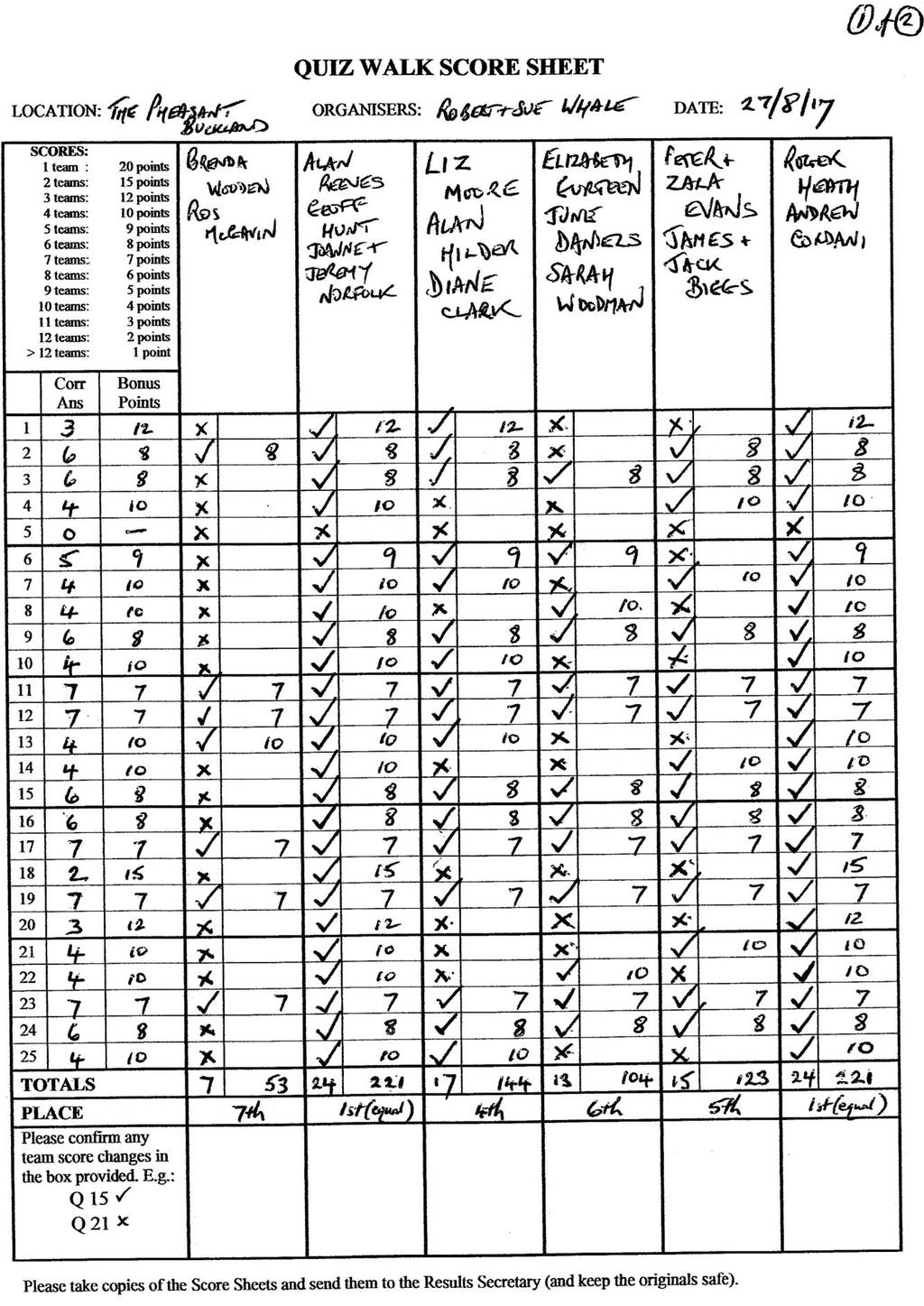
1 Robert and Sue Whale present The Buckland Baffler on Sunday 27th August 2017 at 2.15pm from The Pheasant Reigate Road Buckland Surrey RH3 7BG The Walk: 3.5 miles (5.63 km) on local lanes, footpaths and bridleways, including one short steep path at the side of railway embankment. Six stiles, all of which occur during the first half of the walk, also a further brief climb & descent in vicinity of golf course. The Venue: The Pheasant (formerly the Jolly Farmers) is a Brunning & Price roadhouse with a decentsized car park located on the A25 about halfway between Betchworth and Reigate. A good selection of real ales are offered, typically including beer from such as Surrey Hills, Harveys and Adnams breweries. Excellent quality food is available all day on Sundays, though booking is strongly advised if eating at lunchtime (tel: ). For further details please visit their comprehensive website : OS Sheet 187 Grid Reference: TQ From Reigate town centre. Head west on A25 towards Dorking. The Pheasant is on your left after approximately 2 miles. From intersection of A24 and A25 at Dorking. Head east on A25 towards Reigate. The Pheasant is on your right after approximately 3.5 miles. Public Transport. Unfortunately no buses pass the Pheasant on Sundays. Nearest station is Reigate. For an inexpensive cab service ring Roadrunners on or Belfry cars on

2 Map of Walk Route

3 COMPETITION REMINDER: 20 BOOK TOKEN FOR BEST QUIZ WALK PHOTO IN 2017 Robert & Sue s Quiz Walk. Sunday 27th August 'The Pheasant', Buckland, Surrey. Distance: 3.6 miles Time allowed: 4 hours AT THE PUB: 1. Interpreter of local game? Search & arty lad you'll name 2. This innovation could prove ideal If gran falls asleep when eating her meal 3. Sextet Mozart put together Core group unsettled here, however STAGE 1. Turn left out of pub then after about 100 yards, with great care cross road using traffic island. Continue along main road for a short distance then turn right up Lawrence Lane. After passing electricity sub-station, go through kissing-gate on right and take footpath diagonally left across field. Keep close to trees on your right, then continue ahead towards railway by passing under oak tree in middle of field. Over stile, then with care cross railway, over another stile and diagonally across field. Stage ends at stile at far side. 4. Main man, mask and meter It leads them all as compound completer 5. Where hockey players stayed When no longer plying their trade 6. Coffee table material, say? The lumberjack must have worked all day STAGE 2. Over stile, then soon turn right between farm buildings and back towards railway again. Follow this track round to the left then right through tunnel under the railway line. On reaching STRICTLY PRIVATE gate at far side, cross stile to your left and go up steep slope to top of embankment, then ahead following railway track with barbed wire fence on right (watch out for the stinging nettles here). Stage ends at stile at far end. 7. Set in stone, the contents here Would cost a lot in total I fear 8. Lump of earth that's stuck or dressed? Depends which letter you think best 9. Splat! er, Mr Cow defecated! Somehow this you've negotiated
4 STAGE 3. Cross over stile then go right with open field on left and barbed wire on right. Eventually reach another stile (the last one on this walk!), cross over then bear left. Ignore public footpath to right, instead, keep ahead on track. Right at junction and continue on lane down to main road. Left here and continue to Colley House and Wisteria Cottage on your left, where stage ends. 10. Out with your best friend? Only one of you has to ascend 11. Source of apples and pears? They lost a ton of theirs 12. Where Bonington's babies were maybe enticed and half of all crooks get involved in a heist No clues on the next stretch. Cross over the main road at any point that you feel it is safe between here and the junction with Flanchford Road ahead by the Black Horse pub (you may wish to adjourn there for a drink of course). There are no clues until you have turned right along Flanchford Rd and reached the house "The Green" at which point the QW resumes. STAGE 4. Follow LH side of Flanchford Rd past the cottages, then bear left along bridleway. Continue ahead, passing car park on your right, until eventually reaching golf course. Stage ends at Old School House a short way ahead. 14. This leg of Alp is rough Climbing it might be tough 15. Maybe it has a basement flat Six feet under? Double that 16. Here flow ugly streams Unevenly it seems HISTORICAL NOTE. The next two stages each include part of the very first quiz walk from The relevant sections are underlined in green in the route instructions. STAGE 5. Turn right then immediately left along path with stone and brick wall on your left, until eventually reaching The White House on your left. Now go right across fairway (watch out for golfers). Cross road then take deeply rutted path opposite. This weaves uphill and after a sharp left turn takes you to the car park of Reigate Heath Golf Club. Take a moment to enjoy the fine view here. At far side of car park take path to the right downhill. At the bottom of this sandy path cross towards grey house opposite (look out for golfers on tee to your left before crossing course), then take bridleway ahead at LH side of house. Stage ends at bollard in middle of path after a short distance. 17. Wary but generous entry concession To a possible greyhound racing session? MISSING SPARE CLUE USED 18. When did eagles etc first appear Flying in the breeze up here? Spare Clue. "Fore!" may be heard if round here you roam Sounds more like "four" to those where it's home 19. Two different flappers you might see in flight And not a single robin in sight
5 STAGE 6. Keep ahead on this bridleway, with wire fence on right. The path soon opens out on both sides. Eventually reach T-junction with stream. Here bear right then after ignoring wooden kissing-gate on left, bear round to left and follow path with open field on right all the way to junction of three footpath signs, where stage ends. 20. Quiz walk, as performed 60 years in the past? Part of it's here, in a form that should last 21. Going astray, this might Warn you of C.B.I. plight 22. DWM, maybe needing sedation Is still with us despite lack of operation STAGE 7. Go sharp left then take footpath round to right. Follow the footpath, eventually reaching gate (ignore stile to the right just before). Through gate, left at next junction and follow lane back to main road. Left here, almost immediately arriving at pub. 23. Look for a topical quiz walk setting UK swingers: that's what you're getting 24. It's all right when cut in two But inverting each part you must do 25. Starting again? That sounds painful I know Try it in reverse and solution will show
6 Answers to Quiz Walk from The Pheasant, Buckland. Sunday 27th August ) RAY HARDCASTLE, artist on pub sign (anag. SEARCH, ARTY, LAD) 2) DROP OFF & COLLECTION POINT 3) MOTTEZ on cycle rack (middle letters jumbled in 'sextet Mozart') 4) GAS 5) ESTATE OFFICE (i.e. 'off ice') 6) Old tree cut down and sliced up 7) Big stone trough containing empty Costa Coffee cups 8) CL D on telegraph pole (O or A would make CLOD or CLAD if inserted) 9) DOWDES FARM CATTLE CREEP by tunnel (anag. SPLAT, ER, MR, COW, DEFECATED) 10) Stile with separate way through for dogs 11) (C)OLLEY ORCHARD sign (i.e. missing leading 'C') 12) LITTLE EVEREST house name (ref. Chris B., mountaineer) 13) THE CROFT house name (i.e. CRO(OKS) inside THEFT) 14) Flag pole (anag. LEG, OF, ALP) 15) TWO FATHOMS COTTAGE house name (fathom = six feet) 16) FOUL on drain cover (odd letters of 'FLOW UGLY') 17) CAUTION DOGS RUNNING FREE 18) "Founded 1895" on flag at golf club (eagle = golfing term) (MISSING: Spare clue used) Spare clue: IVY COTTAGE house name (i.e. sounds like IV, Roman numerals for 'four') 19) Black bird on weather vane and BAT burglar alarm (also ref. Batman & Robin) 20) KASP brass padlock (hidden in 'walk as performed') 21) NO PUBLIC RIGHT OF WAY sign on left (anag. WARN, YOU, OF, CBI, PLIGHT) 22) Old windmill visible to your right (DWM is W in DM, plus ILL) 23) BRITISH GATES, BIDDENDEN, KENT set in a diamond, on top of gate 24) KOYA house name (i.e. OK + AY with each element reversed) 25) KIPSTA on basketball net (1st letters of 'again, that, sounds, painful, I, know' reversed)
7
8
6.5 km Circular 2 hours
 REIGATE MILLS AND PILLBOXES A 4 mile (6.5km) enjoyable circular walk from Reigate Heath, passing Reigate Heath windmill, Wonham Mill and pillboxes built during the Second World War. 6.5 km Circular 2 hours
A Sporting Start (2016 Andi Cap)
") Joanne and Jeremy Norfolk present A Sporting Start (2016 Andi Cap) The Sportsman pub, Lower Kingswood, Surrey, KT20 7ES Sunday 23 rd April, 2.15 p.m. The Walk: A fairly easy-going walk, approx. 2.5 miles
Joanne and Jeremy Norfolk present A Sporting Start (2016 Andi Cap) The Sportsman pub, Lower Kingswood, Surrey, KT20 7ES Sunday 23 rd April, 2.15 p.m. The Walk: A fairly easy-going walk, approx. 2.5 miles
The Mendip Way. Route Directions and Maps Wells to Frome
 The Mendip Way Route Directions and Maps Wells to Frome Website: www.mendiphillsaonb.org.uk Email: mendip@mendiphillsaonb.org.uk Facebook & Twitter: @MendipHillsAONB Phone: 01761462338 1 Wells to Shepton
Skirting Reigate s Outskirts Sunday 6th May 2018 Assemble 2.00pm for a 2.15pm Start The Black Horse, 93 West Street, Reigate, Surrey, RH2 9JZ
 Roger & Joyce present Skirting Reigate s Outskirts Sunday 6th May 2018 Assemble 2.00pm for a 2.15pm Start The Black Horse, 93 West Street, Reigate, Surrey, RH2 9JZ The Walk: Just 2.8 miles (4.5km) long,
THE PONTON PLOD - 27 MILE ROUTE
 THE PONTON PLOD - 27 MILE ROUTE Emergency Phone Number 07771 813514 Abbreviations: BW Bridleway X Cross immd immediately FP Footpath TL Turn left L Left thro through KG Kissing Gate TR Turn right R Right
Hammer Vale and Linchmere Common
 point your feet on a new path Hammer Vale and Linchmere Common Distance: 9 km=5½ miles or 6 km=3¾ miles easy walking with one steep section Region: Hampshire, West Sussex Author: Botafuego Refreshments:
RILLINGTON TO MALTON by Tania Dickinson
 RILLINGTON TO MALTON by Tania Dickinson This walk takes you from the Vale of Pickering up on to the Wold scarp, before dropping down again through the pretty village of Settrington and joining the Centenary
NEWLANDS CORNER AND ST MARTHAS
 NEWLANDS CORNER AND ST MARTHAS 10k CIRCULAR ROUTE 2½-3HRS GU4 8SE From Newlands Corner on the North Downs just outside Guildford, you can enjoy one of the most beautiful panoramas of quintessential English
HARDMOORS 26.2 WHITE HORSE HALF ROUTE DESCRIPTION - 018
 HARDMOORS 26.2 WHITE HORSE HALF ROUTE DESCRIPTION - 018 Follow Cleveland Way, keeping to the left hand path (right path is a bike trail) Ignoring any turnings to the left or right At path junction (after
Distance: 9½ km=5¾ miles moderate walking or two walks of 4¼ km=2¾ miles and 6½ km=4 miles
 point your feet on a new path White Hill, Headley Distance: 9½ km=5¾ miles moderate walking or two walks of 4¼ km=2¾ miles and 6½ km=4 miles Region: Surrey Author: Fusszweig Refreshments: Headley Date
9.5 km Circular 3 hours
 RANMORE CIRCULAR A 6 mile (9.5km) circular walk from Boxhill and Westhumble Station in the village of Westhumble, passing through part of the Polesden Lacey Estate, Ranmore Common and Denbies Vineyard.
Robert and Sue Whale present a Sunningdale Sunday Stroll Sunday 7th August 2016 at 2.15pm from The Nag's Head 28 High Street Sunningdale
 Robert and Sue Whale present a Sunningdale Sunday Stroll Sunday 7th August 2016 at 2.15pm from The Nag's Head 28 High Street Sunningdale Berks SL5 0NG www.quizwalks.com or phone 01737 352832 The Walk:
Winterfold Wood. point your feet on a new path. In Brief
 point your feet on a new path Winterfold Wood Distance: 8½ km=5¼ miles Region: Surrey Author: Schwebefuss Refreshments: Windmill Inn, Peaslake after the walk moderate walking with many gradients Date written:
Dorridge & District Residents Association A Walk Along The Green Belt From Dorridge to Catherine-de-Barnes
 Dorridge & District Residents Association A Walk Along The Green Belt From Dorridge to Carine-de-Barnes The starting section of this walk through open fields would be destroyed by building of motorway
Route: Skewsby Foulrice Stearsby
 Route: Skewsby Foulrice Stearsby Distance: 7 miles Map: Explorer: 300 Howardian Hills & Malton Start (OS ref): SE625710 Park in the village of Skewsby. Walk east out of the village to the T-Junction and
Although the majority of these walks are around country lanes you should still follow the Country Code:-
 With the update of the Parish Plan was a request for details of any Walks around Pillaton The following pages give several walks that I and my wife have done for many years. Please be aware that NONE OF
Walk Description. Directions
 Title: Saffron Trail: Battlesbridge to Chelmsford Distance: 14¾ miles Time taken: 6 hours Start Point: Outside the Barge Inn, Battlesbridge OS Explorer Map: 175 & 183 Grid Ref.: TQ 780 947 Transport: Rail:-
LDWA SOUTH DOWNS MARATHON 13 th MAY 2018
 AHD ahead SDW South Downs Way BL/BR bear left/bear right TL/TR turn left/turn right X cross LEG 1 - EAST DEAN to WP1 NORTON GR 470019. Open 1030 to 1300. 9.7 miles. 1.1 From village hall TL and walk to
9.5 km Circular 3 hours
 MEDIEVAL WAVERLEY Challenging Terrain A 6 mile (9.5km) undulating circular walk from Tilford village passing close to The Sands village and the historic ruins of Waverley Abbey. From the top of Crooksbury
Danbury Words and pictures by Laurie Page of the Public Rights of Way team at Essex County Council.
 Danbury Words and pictures by Laurie Page of the Public Rights of Way team at Essex County Council. An undulating walk from Danbury village to the bluebells at the National Trust property of Blakes Wood.
BALCOMBE AND ARDINGLY RESERVOIR, WEST SUSSEX
 BALCOMBE AND ARDINGLY RESERVOIR, WEST SUSSEX 7 miles Circular 4 hours 080816 Challenging Terrain Hi, I'm Luke and this is my West Sussex Weekends walk It's a 7 mile loop from Balcombe rail station, taking
Husthwaite to Byland Abbey
 Husthwaite to Byland Abbey This walk begins with a loop round the village of Husthwaite and continues towards Coxwold along a disused railway line, which is now a right of way. It passes through Coxwold
Walk Description. Directions
 Title: East Hanningfield Distance: 8 miles / 9 miles Time taken: 3-3½ hours Location: 5 miles south east of Chelmsford Parking: Free car park off The Tye, East Hanningfield, next to the primary school
THE DOG AND DUCK HAREWOODS ESTATE TRAIL. 6 Miles Circular 3 hours. Getting there. Walk Sections
 THE DOG AND DUCK HAREWOODS ESTATE TRAIL Moderate Terrain A 6 mile circular pub walk from the Dog and Duck in Outwood, Surrey. The Dog and Duck is a delightful pub where everyone is made welcome. From walkers
THE WELLDIGGERS ARMS, HESWORTH AND FITTLEWORTH TRAIL
 THE WELLDIGGERS ARMS, HESWORTH AND FITTLEWORTH TRAIL 5.5 miles Circular 3 hours 041017 Challenging Terrain A 300-year-old pub turned country-inn on the edge of the South Downs National Park, The Welldiggers
How to get there. Respect - Protect - Enjoy
 How to get there Driving: Postcode is RG9 5PF and there is a car park just across from the pub. Nearest station: Henley-on-Thames station is 5.6 miles away. We re delighted to present three circular walks
SUMMER WALK 10. The Chairmakers, Worlds End
 SUMMER WALK 10 The Chairmakers, Worlds End Tuesday 10 th June 7.30pm This is a very short walk made so due to the majority of the footpaths in the area around the Chairmakers being overrun with high nettles
Welsh Newton and Woodland
 Welsh Newton and Woodland This is a 8.2km miles (approx) walk which will take about 2.5 hours at a relaxed and leisurely pace. There are a few hills but no steep inclines. Start at Llangrove bus stop and
Bagshot Heath and Swinley Forest
 point your feet on a new path Bagshot Heath and Swinley Forest Distance: 13 km=8 miles Region: Berkshire, Surrey Author: Botafuego Refreshments: Forest Look Out, Bagshot easy walking Date written: 17-feb-2013
Hindleap and Vachery Ashdown Forest, Chelwood Gate, Forest Row
 point your feet on a new path Hindleap and Vachery Ashdown Forest, Chelwood Gate, Forest Row Distance: 5 km=9½ miles Region: East Sussex Author: Stivaletti Refreshments: Chelwood Gate, Forest Row Map:
NETTLESTEAD & YALDING
 NETTLESTEAD & YALDING ULL CIRCUIT - Sheet 1 (first and last sections) Open fields (see 'Introductory Notes') 88 Direction label (as in the walk notes) ROADS: 81 10m Significant roads Redhill arm North
Walks Around Bishopstone & Hinton Parva
 The Walks: From ½ mile ambles to 8 mile scenic loops Hinton Parva Walks H1 H2 H3 Bishopstone Walks B1 B2 B3 B4 B5 Walk B1: Bishopstone Village, The Dingle (stream) & Pond A short circular village amble
Bakewell Club Site - Robin Hood's Stride
 Bakewell Club Site - Robin Hood's Stride Camping and Caravanning Route Summary A circular walk with fabulous views winding it's way through the beautiful White Peak scenery. Points of interest include
THE BECK STONE Backstone Beck on Ilkley Moor
 THE BECK STONE Backstone Beck on Ilkley Moor 1 Three different routes which take in the best of the lower slopes of Ilkley Moor, with bracken, heather, a tarn (a small mountain lake) and rushing streams.
10 Miles Circular 5 hours
 VISIT RYEDALE PICKERING AND CAWTHORN CAMPS 10 Miles Circular 5 hours Moderate Terrain 120616 A 10 mile (16km) there and back walk from the market town of Pickering in Ryedale. The route heads north through
Oldbury & Littleton, South Gloucestershire
 Oldbury & Littleton, South Gloucestershire Starts at Church Lane, Oldbury. BS35 1QF 2 hours 0 minutes 5.2miles 8.4km Easy ID: 0.2468 Developed by: GEOFF MULLETT Checked by: Marion Stone www.ramblersroutes.org
Shere Heath and the Hurtwood
 point your feet on a new path Shere Heath and the Hurtwood Distance: 15¾ km=9¾ miles Region: Surrey Author: Schwebefuss Refreshments: Little London moderate-to-easy walking Date written:10-jul-2009 Date
Distance: 14 km=8½ miles or 7 km=4½ miles easy-to-moderate walking
 point your feet on a new path Normandy Distance: 14 km=8½ miles or 7 km=4½ miles easy-to-moderate walking Region: Surrey Author: Botafuego Refreshments: Pirbright, Ash date written: 20-feb-2012 date revised:
Hascombe and Winkworth Arboretum Downs Link Path, Smithbrook Kilns
 point your feet on a new path Hascombe and Winkworth Arboretum Downs Link Path, Smithbrook Kilns Distance: 18 km=11 miles Region: Surrey Author: RDC easy walking Date written: 7-may-2016 Last update: 30-aug-2018
Pilgrims Way and Mole Villages
 point your feet on a new path Pilgrims Way and Mole Villages Distance: 20 km=12½ miles moderate walking with long easy stretches Region: Surrey Author: Schwebefuss Refreshments:, Skimmington Date written:
Stokenchurch. Bluebell Woods, Bomber Memorial, Red Kites, Getty s Cricket Ground, Nature Reserve
 Stokenchurch Bluebell Woods, Bomber Memorial, Red Kites, Getty s Cricket Ground, Nature Reserve Bomber Memorial The best time to visit Cowleaze Wood is in the spring when there is a memorable display of
Distance: 5 km=3 miles or 4½ km=2¾ miles or 3½ km=2 miles
 point your feet on a new path Vann Lake Distance: 5 km=3 miles or 4½ km=2¾ miles or 3½ km=2 miles Region: Surrey Author: Schwebefuss Refreshments: Ockley easy walking Date written: 12-feb-2011 Date revised:
Fertile farms in the heart of Kent
 55 55 Fertile farms in the heart of Kent A bright sunny day is perfect for enjoying the rich and fertile Kent countryside and outstanding views across the valley of the Great Stour to the North Downs.
Approximate distance: 10 miles For this walk we ve included OS grid references should you wish to use them. Start. End
 Approximate distance: 10 miles For this walk we ve included OS grid references should you wish to use them. 2 3 Start End 1 N W E S Reproduced by permission of Ordnance Survey on behalf of HMSO. Crown
LDWA SOUTH DOWNS MARATHON
 AHD ahead SDW South Downs Way BL/BR bear left/bear right TL/TR turn left/turn right SP signpost/fingerpost X cross LEG 1 - EAST DEAN to WP1 NORTON GR 470019. Open 1030 to 1300. 9.6 miles. 1.1 From village
8 Miles Circular 4 hours
 VISIT RYEDALE HELMSLEY AND RICCAL DALE 8 Miles Circular 4 hours 090616 Challenging Terrain An 8 mile (13km) circular walk from the market town of Helmsley in Ryedale. The route heads out across sheep pastures
Harlington - Sharpenhoe - Pulloxhill
 Harlington - Sharpenhoe - Pulloxhill ID: 3676, Distance: 8 miles, Height gain: 140 Metres, Map: Explorer 193 Luton & Stevenage, Contributor: Dennis Jeanes Duration: 3 Hours 27 Mins Features Church,Great
9.5 km Circular 3 hours
 SILENT POOL AND ST MARTHA S HILL Challenging Terrain A 9.5km (6 mile) circular walk in the Surrey Hills, visiting a number of popular attractions including Silent Pool, a stretch of the North Downs Way,
Bonnie Prince Charlie Walk
 Bonnie Prince Charlie Walk A waymarked route from Ashbourne to Derby to celebrate the 60th anniversary (1995) of the formation of the Ramblers' Association. This route follows the general direction of
Dyrham and Hinton Parish Walks
 Dyrham and Hinton Parish Walks A series of five walks in the parish, exploring most of the public footpaths. By John Miller Each walk is described in detail, with a complete map, to provide a handy guide
Follow the Lantern Way clockwise from Dursley Town Hall through Cam & Coaley to Uley and back to Dursley (about 14 miles)
") According to the Rev Kilvert's diary of 1873, couples on their way to evening services in winter followed a practical though unusual local tradition: "My Mother says that at Dursley, when ladies and gentlemen
According to the Rev Kilvert's diary of 1873, couples on their way to evening services in winter followed a practical though unusual local tradition: "My Mother says that at Dursley, when ladies and gentlemen
Cleeve Common Self-Guided Walk 1 Family Circular
 Cleeve Common Self-Guided Walk 1 Family Circular Start point: Quarry Car Park Nearest postcode: GL52 3PW please note this is for the golf club. To find the quarry car park drive past the golf club car
North Downs Way Monster Alternative North Downs Way Double Walk Box Hill or Dorking to Newlands Corner or Guildford
 point your feet on a new path North Downs Way Monster Alternative North Downs Way Double Walk Box Hill or Dorking to Newlands Corner or Guildford Distance: 0 or 6 km=8½ or 6 miles (by rail) or 6 km=½ miles
Slindon Folly - South Downs, West Sussex
 Slindon Folly - South Downs, West Sussex Starts at Park road-side near entrance to Slindon College 2 hours 15 minutes 4.5miles 7.2km Easy ID: 0.1598 Developed by: Chris Mumford Checked by: Rockpit www.ramblersroutes.org
Green Man Ultra Route Directions 2018
 Green Man Ultra Route Directions 2018 Start-CP1 (9 miles) Community Forest Path (CFP) Frome Valley Way (FVW) From the starting line cross the playing fields diagonally to the metal gates in the hedge lined
Meridian Meander Sunday 21st May 2017 Start: 2.15pm The Star Inn Church Road, Lingfield, Surrey RH7 6AH
 Jamie Whale and Darren Goodsell present Meridian Meander Sunday 21st May 2017 Start: 2.15pm The Star Inn Church Road, Lingfield, Surrey RH7 6AH www.quizwalks.com 01737 352832 The Walk: A 4 mile walk from
LOCAL CIRCUIT EM1: EAST MALLING & BARMING HEATH. N 2m ROADS: Significant roads PATHS: Starting direction Barming Longsole Mission Church
 Ditton Church Scott Close LOCAL CIRCUIT EM1: EAST MALLING & BARMING HEATH 6 Community Centre F Open fields (see 'Introductory Notes') 1m 88 Direction label (as in the walk notes) East Malling Church -
EAST GRINSTEAD AND THE HIGH WEALD, WEST SUSSEX
 EAST GRINSTEAD AND THE HIGH WEALD, WEST SUSSEX 7 miles Circular 3.5 hours 301015 Challenging Terrain Hi, I'm Tom and this is my West Sussex Weekends walk. I live and work in London but often head out of
Poundgate and The Hurstwood
 point your feet on a new path Poundgate and The Hurstwood Distance: 11 km=7 miles Region: East Sussex Author: Stivaletti Refreshments: High Hurstwood easy walking Date written: 24-jul-2016 Last update:
This walk description is from happyhiker.co.uk
 This walk description is from happyhiker.co.uk Pendle Hill Walk From Barley Starting point and OS Grid reference Ordnance Survey map Distance Traffic light rating Barley village honesty box car park OS
Redesdale Arms. A Trio of Walks
 Redesdale Arms A Trio of Walks Welcome to The Redesdale Arms Hotel The award winning 34 bedroom Redesdale Arms Hotel sits at the gateway to the Cotswolds in the High Street of the historic town of Moreton-in-Marsh.
Beautiful Walks from the Blue Ball Inn
 Walk No. 7 COAST AND VALLEY WALK Countisbury, Glenthorne, County Gate, Brendon, Rockford and Wilsham 10 MILES APPROX. Walking time 5 hours approx. (not including breaks)> OS Sheet 64/74 Lynton and Lynmouth.
holly tree Wellhill Farm Woodyard Bramham House red kites Round House ha-ha
 This 6.4 mile walk around the magnificent Bramham Park Estate has been made possible with the active support of the owner of the Estate, Nick Lane Fox, with funding from Natural England, as part of Defra
Waterhead Pier to Orrest Head, Windermere and Bowness
 Waterhead Pier to Orrest Head, Windermere and Bowness A 4 1 2 hour walk through Woodlands and the Troutbeck Valley with spectacular Lake and Mountain views and a lakeshore path. Walk 10 Walk 11 Walk 12
Blackheath and Shamley Green
 point your feet on a new path and Shamley Green Distance: 14 km=9 miles Region: Surrey Author: Schwebefuss Refreshments:, Shamley Green easy walking with one climb Date written: 27-jun-2009 Date revised:
The North Pennines from near Langwathby
 3.6 Langwathby to Armathwaite Map panel?? Distance 12.7 miles (20.5 km) Terrain farm, woodland and riverside paths; some potentially muddy tracks; a few short sections of road Grade gently undulating Food
Hitchin Nomads Cycling Club
 Hitchin Nomads Cycling Club Risk Assessment of Course Course Identification 1U/25 25 Miles - Southill / Old Warden Reviewed By Paul Riley Reviewed On 02/01/2018 Course Details https://www.plotaroute.com/route/346809
Great Barford and The River Great Ouse
 Great Barford and The River Great Ouse A riverside route which follows the River Great Ouse, with historic sites at Barford Bridge, Danish Camp and Willington Dovecote Essential Facts Route distance: Approximate
Tideswell to Castleton
 Tideswell to Castleton 1 Walk summary Length: 14 km, 8.5 miles Maps: OS Explorer OL1 The Peak District - Dark Peak Area, OS Explorer OL24 The Peak District - White Peak Area, OS Landranger 110 Sheffield
Thornton le Dale Walks
 Thornton le Dale Walks A collection of walks in and around the village Thornton le Dale Traders Forum www.visitthorntonledale.co.uk Thornton le Dale Walks Walk 1: Beck Isle Cottage and All Saints Church
Fernhurst and the Temple of the Winds
 point your feet on a new path Fernhurst and the Temple of the Winds Distance: 8 km=5 miles Region: West Sussex Author: Hautboy Refreshments: Fernhurst moderate walking Date written: 12-sep-2012 Last update:
Walk 7: Watchet to washford
 Walk 7: Watchet to washford Length: Moderate - 7.5 miles / 12 km Good For: Theme: History Duration: 2-3 hours depending on speed of walking Notes: This is a moderate to difficult walk in places, with steps,
Uif!Sfe!Mjpn-!Mpnhepn! bne!dbnnpdl!dibtf-! Tubggpsetijsf
 Uif!Sfe!Mjpn-!Mpnhepn! bne!dbnnpdl!dibtf-! Tubggpsetijsf 7/6!njmft! Djsdvmbs!!!!!!! 4!up!4/6! ipvst Strenuous Terrain Uif!Sfe!Mjpn!jt!b!dmbttjd!wjmmbhf!qvc-!b! hsfbu!qmbdf!up!tbujtgz!zpvs!ivnhfs!bgufs!b!
Cliveden Cross Country Sunday 7 January 2018, 9.00am Under UK Athletics Rules SEAA Race Permit
 Cliveden Cross Country Sunday 7 January 2018, 9.00am Under UK Athletics Rules SEAA Race Permit 2018 31623 Welcome to another post-christmas test of endurance and fitness at Cliveden presented by kind permission
The main feature of this tranquil walk is a visit to the source of the Thames (the Thames head) which is in a field just 3 km from Kemble station
 which is in a field just 3 km from Kemble station") SWC Walk DRAFT Kemble circular: the source of the River Thames. The main feature of this tranquil walk is a visit to the source of the Thames (the Thames head) which is in a field just 3 km from Kemble
SWC Walk DRAFT Kemble circular: the source of the River Thames. The main feature of this tranquil walk is a visit to the source of the Thames (the Thames head) which is in a field just 3 km from Kemble
Approximate distance: 5.5 miles For this walk we ve included OS grid references should you wish to use them. Start. End
 Approximate distance: 5.5 miles For this walk we ve included OS grid references should you wish to use them. End 4 1 Start 3 2 N W E S Reproduced by permission of Ordnance Survey on behalf of HMSO. Crown
Dragonflies and a Church-on-the-Hill Chantries, Shalford, Blackheath
 point your feet on a new path Dragonflies and a Church-on-the-Hill Chantries, Shalford, Blackheath Distance: 16 km=10 miles Region: Surrey Author: Schwebefuss Refreshments: Shalford (choice of two) easy-to-moderate
Lincolnshire Walks. Ancaster. Three cir cular walks of2 3/4,4or 6km (11/3, 21/2 or 33/4 miles)
") Lincolnshire Walks Ancaster Three cir cular walks of2 3/4,4or 6km (11/3, 21/2 or 33/4 miles) Introduction These walks are set in the attractive countryside around the historic town of Ancaster. The town
Lincolnshire Walks Ancaster Three cir cular walks of2 3/4,4or 6km (11/3, 21/2 or 33/4 miles) Introduction These walks are set in the attractive countryside around the historic town of Ancaster. The town
The Alice Lisle Walking Guide
 The Alice Lisle Walking Guide Using some local knowledge we have been able to design some great walks starting and finishing at the Alice Lisle. If you re planning a group walk, please get in contact with
Masson Hill. Walk. Approximately 4 km. Moderate Walk Begins from Matlock Railway Station
 Masson Hill Walk Approximately 4 km Moderate Walk Begins from Matlock Railway Station TOWN WALKS Masson Hill walk is approx. 4 km. It can be walked in a couple of hours or so. Enjoy your walk and the beautiful
WETHERBY CIRCULAR by Tania Dickinson
 WETHERBY CIRCULAR by Tania Dickinson This walk in lower Wharfedale includes a disused railway line at the beginning and riverside at the end, with parkland, fields, woodland and villages in between. Distance
Effingham to Westhumble
 Main walk morning last checked Main walk afternoon last checked Pub diversion last checked Westhumble Circular last checked 12 December 2017 23 December 2017 19 August 2015 27 October 2017 Document last
A Walk In The Park The Duke's Head Wallington 2:15pm Sunday the 2 nd of July 2017
 Kiran and Zara Evans present A Walk In The Park The Duke's Head Wallington 2:15pm Sunday the 2 nd of July 2017 Organisers' mobile number: 07910159334 THE WALK 2.8 miles, no stiles, steps or kissing gates.
A Walk around Holmes Chapel starting & finishing at Holmes Chapel Railway Station. by Tony & Lindsay Wright (2016)
") A Walk around Holmes Chapel starting & finishing at Holmes Chapel Railway Station. by Tony & Lindsay Wright (2016) Introduction Holmes Chapel Railway Station is on the Crewe to Manchester line. The station
A Walk around Holmes Chapel starting & finishing at Holmes Chapel Railway Station. by Tony & Lindsay Wright (2016) Introduction Holmes Chapel Railway Station is on the Crewe to Manchester line. The station
Thornton le Dale Walks
 Thornton le Dale Walks A collection of circular walks in, and around, the village www.visitthorntonledale.co.uk Thornton-le-Dale Traders Forum and Thornton le Dale Parish Council 1 Thornton le Dale Circular
Other useful information Nearest Refreshments: In the Victoria Inn or the Lugger Inn, in Chickerell OS Explorer Map: OL15 (Purbeck and South Dorset)
") they find the diamond, and then to Holland, where they try to sell it, finding themselves in worse trouble than ever as a result. It is ten years before John returns to Moonfleet, fortuitously being shipwrecked
they find the diamond, and then to Holland, where they try to sell it, finding themselves in worse trouble than ever as a result. It is ten years before John returns to Moonfleet, fortuitously being shipwrecked
SIX WALKS FROM SHRIGLEY HALL HOTEL COLLECT A COPY FROM HOTEL RECEPTION (PLEASE NOTE, WALKING AROUND OR ACROSS THE GOLF COURSE IS NOT PERMITTED)
") SIX WALKS FROM SHRIGLEY HALL HOTEL COLLECT A COPY FROM HOTEL RECEPTION (PLEASE NOTE, WALKING AROUND OR ACROSS THE GOLF COURSE IS NOT PERMITTED) SH WALK 1 - SHRIGLEY HALL THE NAB LENTH: 2.5 MILES. GRADIENT:
SIX WALKS FROM SHRIGLEY HALL HOTEL COLLECT A COPY FROM HOTEL RECEPTION (PLEASE NOTE, WALKING AROUND OR ACROSS THE GOLF COURSE IS NOT PERMITTED) SH WALK 1 - SHRIGLEY HALL THE NAB LENTH: 2.5 MILES. GRADIENT:
TOCKENHAM. Walks for Healthy Living. The Countryside Code (October 2016) Respect other people:
 Respect other people:") The Countryside Code (October 2016) TOCKENHAM Respect other people: consider the local community and other people enjoying the outdoors leave gates and property as you find them and follow paths unless
The Countryside Code (October 2016) TOCKENHAM Respect other people: consider the local community and other people enjoying the outdoors leave gates and property as you find them and follow paths unless
WALK 1 - SHRIGLEY HALL THE NAB LENGTH: 2.5 MILES. GRADIENT: CHALLENGING. STOUT FOOTWEAR REQUIRED
 SIX WALKS FROM SHRIGLEY HALL HOTEL COLLECT A COPY FROM HOTEL RECEPTION 1 (PLEASE NOTE, WALKING AROUND OR ACROSS THE GOLF COURSE IS NOT PERMITTED) WALK 1 - SHRIGLEY HALL THE NAB LENGTH: 2.5 MILES. GRADIENT:
Distance: 11 km=7 miles or 8 km=5 miles easy walking with two short steepish sections
 point your feet on a new path Common Distance: km=7 miles or 8 km=5 miles easy walking with two short steepish sections Region: Surrey Author: Schwebefuss Refreshments: Chart, Moorhouse Date written: 7-dec-05
Heartwood Forest, in Sandridge, Hertfordshire, is a place where everyone can find space, peace, wildlife and miles of beautiful woodland to explore.
 Heartwood Forest Accessibility Statement September 2016 Purpose: This accessibility statement outlines the available facilities and access information for Heartwood Forest. Welcome We, the Woodland Trust,
CHINTHURST HILL AND THE GRANTLEY ARMS, SURREY
 CHINTHURST HILL AND THE GRANTLEY ARMS, SURREY 4 miles Circular 2 hours 110417 Challenging Terrain A 4 mile (can be shortened to 3 miles) circular pub walk near Wonersh in Surrey. The walk begins with an
Caterham and the North Downs Way
 point your feet on a new path Caterham and the North Downs Way Distance: 9½ km=6 miles Region: Surrey Author: Fusszweig Refreshments: Caterham easy walking with one short climb Date written: 3-dec-2016
GENERAL INFORMATION PLEASE FOLLOW THE COUNTRYSIDE CODE:
 KNIGHTON CIRCULAR WALKS The East Radnor Group of the Ramblers Association invites you to enjoy these walks around Knighton. Knighton is an excellent centre for walks in the lovely unspoilt mid-wales countryside
Where did it all go wrong, George?
 Where did it all go wrong, George? Those readers of a certain age will recognise the above quotation. Uttered by the waiter on room service, as he entered George Best s hotel bedroom, to see him in bed
Uif!Cmbdl!Kvh!bne! Wbsnibn!Qbsl-!Ipstibn-! Wftu!Tvttfy
 Uif!Cmbdl!Kvh!bne! Wbsnibn!Qbsl-!Ipstibn-! Wftu!Tvttfy 7/6!njmft! Djsdvmbs!!!! 3/6!up!4! ipvst 200114 Moderate Terrain Uif!Cmbdl!Kvh!jt!b!hsfbu!upxn!qvc!dfnusfe! bspvne!b!mbshf!cbs!xjui!xppefn!qbnfmmjnh-!
Outwood: oaks, buttercups and windmill
 point your feet on a new path Outwood: oaks, buttercups and windmill Distance: 9 km=5½ miles Region: Surrey Author: Schwebefuss Refreshments: Outwood easy walking Date written: 23-may-2014 Last update:
A mainly flat walk along the Peak Forest Canal to Castle Hill and returning along the River Tame via Hulmes Wood and Haughton Dale.
 Walk 9 Haughton Green, Peak Forest Canal, Castle Hill, Hulmes Wood, River Tame, Haughton Dale Circular Miles: 3.9 Time: 1 Hour 30 Minutes Grade: Easy To Moderate Starting Point: Junction Of Gibraltar Lane/Newport
11 Miles Linear 5 to 6 hours
 11 Miles Linear 5 to 6 hours Sussex Hospices Trail Part 21: BALCOMBE TO HORSHAM Moderate Terrain 030918 An 11 mile linear walk from Balcombe rail station to Horsham rail station in West Sussex, forming
Walk 2: Beamsley Beacon and Bolton Abbey
 Walk 2: Beamsley Beacon and Bolton Abbey Start and Finish: The Memorial Hall, Main Street, Addingham, LS29 0LZ, SE 079 497 The shortest walk is about 5½ miles (8.8km) The medium Walk is about 8¼ miles