Skirting Reigate s Outskirts Sunday 6th May 2018 Assemble 2.00pm for a 2.15pm Start The Black Horse, 93 West Street, Reigate, Surrey, RH2 9JZ
|
|
|
- Warren Payne
- 5 years ago
- Views:
Transcription
 long, mostly on footpaths and quiet backstreets, this walk takes in a pleasant area in the lee of the North Downs we haven t explored in quite a while. No stiles.")
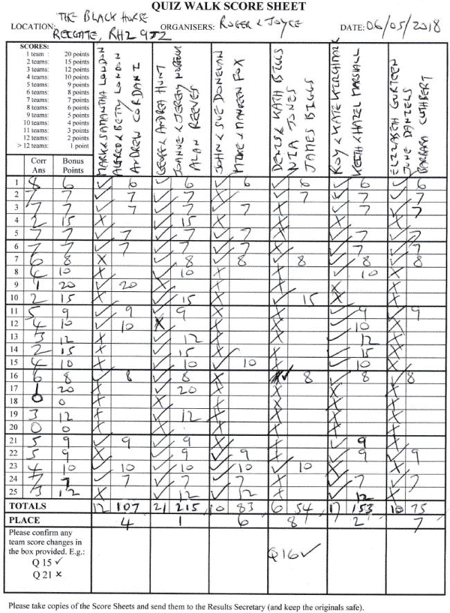
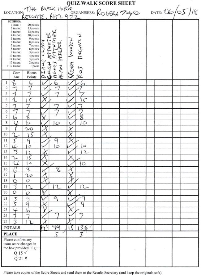
1 Roger & Joyce present Skirting Reigate s Outskirts Sunday 6th May 2018 Assemble 2.00pm for a 2.15pm Start The Black Horse, 93 West Street, Reigate, Surrey, RH2 9JZ The Walk: Just 2.8 miles (4.5km) long, mostly on footpaths and quiet backstreets, this walk takes in a pleasant area in the lee of the North Downs we haven t explored in quite a while. No stiles. Some gradients in the first half but not steep. Not ideal for buggies in a couple of places but passable. The Venue: Pub was taken over by the White Brasserie Company last summer and judging by our personal experience the food is now very good. Sunday roast costs around 15/ 16. BOOK EARLY for a restaurant meal. Wide-ranging bar menu also available. Real ale includes Sharps Doombar. Child friendly and dog friendly. If car park full, park in nearby Flanchford Road. Tel or visit their website at OS Grid Reference: TQ Directions: (From Reigate town centre) Head west on A25 towards Dorking. After about 0.7 miles pub is on the left just before turning into Flanchford Road. (From intersection of A24 and A25 at Dorking) Head east on A25 towards Reigate. After about 4.7 miles pub is on the right at junction of West Street and Flanchford Road.. Public Transport: No buses stop close to the pub on Sunday. Nearest station is Reigate, just under a mile away. For an inexpensive cab service ring Roadrunners on or Belfry cars on

2 Skirting Reigate s Outskirts - Map of Route

3 Roger and Joyce present Skirting Reigate s Outskirts The Black Horse, 93 West Street Reigate, Surrey, RH2 9JZ Sunday 6th May, 2018 at 2.15pm Distance: 2.8 miles Time Allowed: 4 hours PHOTO COMPETITION REMINDER-KEEP TAKING THOSE 2018 QUIZWALKING SNAPS 20 BOOK TOKEN FOR BEST PHOTO UP FOR GRABS! NO HOUSE NAMES KIDS CLUES are in bold at start of each stage but answers could be anywhere on the stage KIDS I SPY Write down all the words/things you see anywhere on this quizwalk containing the letter S (No plurals or house names) Starter Clues Q1 Q1 Q2 Q3 Not on the horse s hoof today. Draw me the one that got away. Nightmare on board? Misnomer almost complete. Little grown to eat. Once a tax avoidance play It doesn t save a penny today. Stage 1 (No answers on underlined section) Leaving pub cross main road and turn right along West Street. Continue to Public Footpath on left beside telegraph pole DP 188. Left up this footpath. Continue all the way until reaching Public Footpath disc on wooden half barrier. Q2 Q4 Q5 Q6 For sure this bod Is Mr Plod. Did its welcome cause This burst of applause? Attractive kitchen design? Equipped like Thatcher, that s for sure. And on the right side of the law.
4 Stage 2 Ahead on roadway. Soon cross above railway and keep ahead, passing Manor Road on right. Proceed some way until reaching a fork in road denoted by The Clears. Q3 Q7 Struck by a jolt From a lightning bolt? Design aligns With traffic on lines. Q8 On 29/2 just a thought Do all precautions come to naught? Q9 Supporting singers trait Is failure to aspirate. Stage 3 Keep left along The Clears. At junction ignore Colley Way on right and continue along The Clears. On reaching two-way pointer post at next junction keep round to right, still on The Clears. Proceed to Public Footpath sign atop metal pole on left. Q4 Q10 Q11 Look for Farleigh that s the clue. Will postman Pat come into view? Where a steel arch is found But not at Wembley s ground. Starting out with a chippy surely was wrong. This pad s upper section is much more strong. Q12 Type of music that will play At the home of Theresa May? Stage 4 Follow Public Footpath round to right. After passing Whitings on left keep ahead until metal gate marked Footpath bars the way. Ahead on gentle uphill climb. Eventually pass bicycle disc on left and reach track at right angles. Q5 Q13 Q14 Two wheels here that s very plain. What is missing is called a _ Voting that Has fallen flat? Done with ease With skeleton keys? Stage 5 Left. Stay on main track until reaching four way pointer post. Left here down Public Bridleway. End stage at post on right with Public Byway discs round it. Q6 Q15 Q16 At the pointer post please say: To what does the acorn point the way? In my beginning is my end, Setting a peripatetic trend. Copiously found On poisoned ground?
5 Stage 6 Ahead. At roadway straight on. After passing under bridge end stage at Gas plate on right just past The Old Manor. Q7 Q17 Q18 Q19 It s a camera that you see Along with the letters Not in formation, but solo found.and where it hurriedly came to ground? Technical description seems plain wrong. Surely suspended all way along. Q20 From the heart given. And easily taken? Stage 7 Stay on this road. End stage on reaching main road at right angles. Q8 Q21 Q22 As a foot-piece wide and thick. For climbing over it does the trick. Putting on front as if to state: Making fun of Henry Eight. Arrivals that over-compensate After a very longish wait? Stage 8 (All answers on nearside of road) Left. Stay on pavement until reaching red pillar box opposite pub. Q9 Q23 Q24 Q25 Two seen here just shuffling along. The words below explain what s wrong. Utter defeatism. Throwback to Aboriginal times? Dora, perhaps? She could well be Atop the academic tree. Spare Clue (in same area as starting questions) Q26 Record-keeper not playing by the book, But said to be acting like a crook?
6 Roger and Joyce present Answers Q1 Q2 Q3 Q4 Q5 Q6 Q7 Q8 Q9 Q10 Q11 Q12 Q13 Q14 Q15 Q16 Q17 Q18 Q19 Q20 Q21 Q22 Q23 Q24 Q25 Q26 Skirting Reigate s Outskirts The Black Horse, 93 West Street, Reigate, Surrey, RH2 9JZ Sunday 6th May, 2018 at 2.15pm Distance: 2.8 miles Time Allowed: 4 hours Image of black horse on board pub sign outside pub. Veg Table on trough holding mainly flowers outside pub. Bricked-up windows at left side of pub. INN-OVATION on cover on wall of building on right. G-RANGE STYLE on metal tag on boarded fence. Woman with handbag standing on right of policeman on Neighbourhood Watch notice. Signal (anagram of aligns ) at side of railway line. Workplace Safety 365 on sign in Network Rail enclosure. Corus (c.f. C- h-orus) - on lamppost on right. The Clears (anagram of steel arch ) name of road. House with wooden-walled lower section and hard-walled upper section at junction with Colley Lane. 10 on garage at bottom of garden on right. Level crossing on sign at house called Whitings. Master lock on padlock on gate on right. Circular Walk on circular plate on four-way pointer post. Ground-hugging ivy to left and right of track. Red arrow on Public Byway disc. Ditch to left of roadway beside SES Water compound. This is bridge ELR-RSJ structure Clifton s Bridge on plate at bridge. 5 ( gi-v-en and the saying Take Five) on speed limit sign on telegraph pole. Mock tudor house fronts on either side of roadway. A-bus on two padlocks on Grit container. Never wonne ne never shall on heraldry image on Colley Manor Drive name-plate. Boomerang-shaped curve - on bend sign. New Road Layout A-head (anagram of road and school head slant) on road sign. Clark-Steel on manhole in pavement in front of pub. Young Walkers Answers Q1 Q2 Q3 Q4 Q5 Q6 Q7 Q8 Q9 Horseshoe on pub sign. Policeman on Neighbourhood Watch notice. Prostrate figure beneath electric bolt on Danger of Death sign at transformer compound. Wooden post-box housing outside house called Farleigh. Chain missing from cycle image on disc attached to post. North Downs Way on wooden pointer post with acorn symbol. CCTV on camera sign at SES Water compound. Makeshift stile with long foot-piece formed by large, thick plank in fence on right. Elderly man and woman on Disabled People road sign at road verge. Scoring: Ten points for each correct answer given to questions 1 to 9 above. I spy question - one point for each valid word, up to a maximum of 40 words.
7
8
A Sporting Start (2016 Andi Cap)
") Joanne and Jeremy Norfolk present A Sporting Start (2016 Andi Cap) The Sportsman pub, Lower Kingswood, Surrey, KT20 7ES Sunday 23 rd April, 2.15 p.m. The Walk: A fairly easy-going walk, approx. 2.5 miles
Joanne and Jeremy Norfolk present A Sporting Start (2016 Andi Cap) The Sportsman pub, Lower Kingswood, Surrey, KT20 7ES Sunday 23 rd April, 2.15 p.m. The Walk: A fairly easy-going walk, approx. 2.5 miles
Robert and Sue Whale present The Buckland Baffler on Sunday 27th August 2017 at 2.15pm from The Pheasant Reigate Road Buckland Surrey RH3 7BG
 Robert and Sue Whale present The Buckland Baffler on Sunday 27th August 2017 at 2.15pm from The Pheasant Reigate Road Buckland Surrey RH3 7BG The Walk: 3.5 miles (5.63 km) on local lanes, footpaths and
Danbury Words and pictures by Laurie Page of the Public Rights of Way team at Essex County Council.
 Danbury Words and pictures by Laurie Page of the Public Rights of Way team at Essex County Council. An undulating walk from Danbury village to the bluebells at the National Trust property of Blakes Wood.
The Mendip Way. Route Directions and Maps Wells to Frome
 The Mendip Way Route Directions and Maps Wells to Frome Website: www.mendiphillsaonb.org.uk Email: mendip@mendiphillsaonb.org.uk Facebook & Twitter: @MendipHillsAONB Phone: 01761462338 1 Wells to Shepton
9.5 km Circular 3 hours
 RANMORE CIRCULAR A 6 mile (9.5km) circular walk from Boxhill and Westhumble Station in the village of Westhumble, passing through part of the Polesden Lacey Estate, Ranmore Common and Denbies Vineyard.
Winterfold Wood. point your feet on a new path. In Brief
 point your feet on a new path Winterfold Wood Distance: 8½ km=5¼ miles Region: Surrey Author: Schwebefuss Refreshments: Windmill Inn, Peaslake after the walk moderate walking with many gradients Date written:
9.5 km Circular 3 hours
 MEDIEVAL WAVERLEY Challenging Terrain A 6 mile (9.5km) undulating circular walk from Tilford village passing close to The Sands village and the historic ruins of Waverley Abbey. From the top of Crooksbury
Hammer Vale and Linchmere Common
 point your feet on a new path Hammer Vale and Linchmere Common Distance: 9 km=5½ miles or 6 km=3¾ miles easy walking with one steep section Region: Hampshire, West Sussex Author: Botafuego Refreshments:
Husthwaite to Byland Abbey
 Husthwaite to Byland Abbey This walk begins with a loop round the village of Husthwaite and continues towards Coxwold along a disused railway line, which is now a right of way. It passes through Coxwold
Distance: 9½ km=5¾ miles moderate walking or two walks of 4¼ km=2¾ miles and 6½ km=4 miles
 point your feet on a new path White Hill, Headley Distance: 9½ km=5¾ miles moderate walking or two walks of 4¼ km=2¾ miles and 6½ km=4 miles Region: Surrey Author: Fusszweig Refreshments: Headley Date
Distance: 14 km=8½ miles or 7 km=4½ miles easy-to-moderate walking
 point your feet on a new path Normandy Distance: 14 km=8½ miles or 7 km=4½ miles easy-to-moderate walking Region: Surrey Author: Botafuego Refreshments: Pirbright, Ash date written: 20-feb-2012 date revised:
10 Miles Circular 5 hours
 VISIT RYEDALE PICKERING AND CAWTHORN CAMPS 10 Miles Circular 5 hours Moderate Terrain 120616 A 10 mile (16km) there and back walk from the market town of Pickering in Ryedale. The route heads north through
RILLINGTON TO MALTON by Tania Dickinson
 RILLINGTON TO MALTON by Tania Dickinson This walk takes you from the Vale of Pickering up on to the Wold scarp, before dropping down again through the pretty village of Settrington and joining the Centenary
Walk Description. Directions
 Title: Saffron Trail: Battlesbridge to Chelmsford Distance: 14¾ miles Time taken: 6 hours Start Point: Outside the Barge Inn, Battlesbridge OS Explorer Map: 175 & 183 Grid Ref.: TQ 780 947 Transport: Rail:-
6.5 km Circular 2 hours
 REIGATE MILLS AND PILLBOXES A 4 mile (6.5km) enjoyable circular walk from Reigate Heath, passing Reigate Heath windmill, Wonham Mill and pillboxes built during the Second World War. 6.5 km Circular 2 hours
Harlington - Sharpenhoe - Pulloxhill
 Harlington - Sharpenhoe - Pulloxhill ID: 3676, Distance: 8 miles, Height gain: 140 Metres, Map: Explorer 193 Luton & Stevenage, Contributor: Dennis Jeanes Duration: 3 Hours 27 Mins Features Church,Great
Dorridge & District Residents Association A Walk Along The Green Belt From Dorridge to Catherine-de-Barnes
 Dorridge & District Residents Association A Walk Along The Green Belt From Dorridge to Carine-de-Barnes The starting section of this walk through open fields would be destroyed by building of motorway
Hascombe and Winkworth Arboretum Downs Link Path, Smithbrook Kilns
 point your feet on a new path Hascombe and Winkworth Arboretum Downs Link Path, Smithbrook Kilns Distance: 18 km=11 miles Region: Surrey Author: RDC easy walking Date written: 7-may-2016 Last update: 30-aug-2018
Greenwood. Walks. Cossall Canal Walk. Cossall Canal Walk
 Cossall Canal Walk C5 Cossall Canal Walk C5 Features: Cossall is a picturesque, relatively unspoiled village on the Nottingham canal, four miles south-east of Eastwood. Architecturally interesting. See
How to get there. Respect - Protect - Enjoy
 How to get there Driving: Postcode is RG9 5PF and there is a car park just across from the pub. Nearest station: Henley-on-Thames station is 5.6 miles away. We re delighted to present three circular walks
Route: Skewsby Foulrice Stearsby
 Route: Skewsby Foulrice Stearsby Distance: 7 miles Map: Explorer: 300 Howardian Hills & Malton Start (OS ref): SE625710 Park in the village of Skewsby. Walk east out of the village to the T-Junction and
The Hundred Parishes
 The Hundred Parishes Walks from railway stations number 9 6.4 miles (10kms) from Bishop s Stortford to Stansted Mountfitchet Start: Bishop s Stortford station (Grid Reference TL492209) (ample parking and
BALCOMBE AND ARDINGLY RESERVOIR, WEST SUSSEX
 BALCOMBE AND ARDINGLY RESERVOIR, WEST SUSSEX 7 miles Circular 4 hours 080816 Challenging Terrain Hi, I'm Luke and this is my West Sussex Weekends walk It's a 7 mile loop from Balcombe rail station, taking
Dyrham and Hinton Parish Walks
 Dyrham and Hinton Parish Walks A series of five walks in the parish, exploring most of the public footpaths. By John Miller Each walk is described in detail, with a complete map, to provide a handy guide
Distance: 5 km=3 miles or 4½ km=2¾ miles or 3½ km=2 miles
 point your feet on a new path Vann Lake Distance: 5 km=3 miles or 4½ km=2¾ miles or 3½ km=2 miles Region: Surrey Author: Schwebefuss Refreshments: Ockley easy walking Date written: 12-feb-2011 Date revised:
THE DOG AND DUCK HAREWOODS ESTATE TRAIL. 6 Miles Circular 3 hours. Getting there. Walk Sections
 THE DOG AND DUCK HAREWOODS ESTATE TRAIL Moderate Terrain A 6 mile circular pub walk from the Dog and Duck in Outwood, Surrey. The Dog and Duck is a delightful pub where everyone is made welcome. From walkers
8 Miles Circular 4 hours
 VISIT RYEDALE HELMSLEY AND RICCAL DALE 8 Miles Circular 4 hours 090616 Challenging Terrain An 8 mile (13km) circular walk from the market town of Helmsley in Ryedale. The route heads out across sheep pastures
A mainly flat walk along the Peak Forest Canal to Castle Hill and returning along the River Tame via Hulmes Wood and Haughton Dale.
 Walk 9 Haughton Green, Peak Forest Canal, Castle Hill, Hulmes Wood, River Tame, Haughton Dale Circular Miles: 3.9 Time: 1 Hour 30 Minutes Grade: Easy To Moderate Starting Point: Junction Of Gibraltar Lane/Newport
THE PONTON PLOD - 27 MILE ROUTE
 THE PONTON PLOD - 27 MILE ROUTE Emergency Phone Number 07771 813514 Abbreviations: BW Bridleway X Cross immd immediately FP Footpath TL Turn left L Left thro through KG Kissing Gate TR Turn right R Right
NEWLANDS CORNER AND ST MARTHAS
 NEWLANDS CORNER AND ST MARTHAS 10k CIRCULAR ROUTE 2½-3HRS GU4 8SE From Newlands Corner on the North Downs just outside Guildford, you can enjoy one of the most beautiful panoramas of quintessential English
Slindon Folly - South Downs, West Sussex
 Slindon Folly - South Downs, West Sussex Starts at Park road-side near entrance to Slindon College 2 hours 15 minutes 4.5miles 7.2km Easy ID: 0.1598 Developed by: Chris Mumford Checked by: Rockpit www.ramblersroutes.org
How to get there. Respect - Protect - Enjoy
 How to get there Driving: Postcode is OX10 6AD with a car park for customers. Nearest station: Goring & Streatley station is 5.6 miles away. We re delighted to present three circular walks all starting
This walk description is from happyhiker.co.uk
 This walk description is from happyhiker.co.uk Pendle Hill Walk From Barley Starting point and OS Grid reference Ordnance Survey map Distance Traffic light rating Barley village honesty box car park OS
WETHERBY CIRCULAR by Tania Dickinson
 WETHERBY CIRCULAR by Tania Dickinson This walk in lower Wharfedale includes a disused railway line at the beginning and riverside at the end, with parkland, fields, woodland and villages in between. Distance
LDWA SOUTH DOWNS MARATHON 13 th MAY 2018
 AHD ahead SDW South Downs Way BL/BR bear left/bear right TL/TR turn left/turn right X cross LEG 1 - EAST DEAN to WP1 NORTON GR 470019. Open 1030 to 1300. 9.7 miles. 1.1 From village hall TL and walk to
A Walk In The Park The Duke's Head Wallington 2:15pm Sunday the 2 nd of July 2017
 Kiran and Zara Evans present A Walk In The Park The Duke's Head Wallington 2:15pm Sunday the 2 nd of July 2017 Organisers' mobile number: 07910159334 THE WALK 2.8 miles, no stiles, steps or kissing gates.
Guildford Circular via Chantries Hill
 Main walk and option b) last checked Chilworth options last checked Shalford options last checked 28 October 2017 16 January 2018 28 October 2017 Document last updated: 15 March 2018 This document and
THE WELLDIGGERS ARMS, HESWORTH AND FITTLEWORTH TRAIL
 THE WELLDIGGERS ARMS, HESWORTH AND FITTLEWORTH TRAIL 5.5 miles Circular 3 hours 041017 Challenging Terrain A 300-year-old pub turned country-inn on the edge of the South Downs National Park, The Welldiggers
Loch Ness Shores Club Site
 Loch Ness Shores Club Site Camping and Caravanning Falls of Foyers Route Summary A strenuous walk from Loch Ness Shores Club Site. The route climbs through forest to The Upper Foyers Waterfall and then
How to get there. Respect - Protect - Enjoy
 How to get there Driving: Postcode is OX49 5HL with a car park for customers Nearest station: Henley on Thames station is 9.5 miles away. We re delighted to present three circular walks all starting and
CHINTHURST HILL AND THE GRANTLEY ARMS, SURREY
 CHINTHURST HILL AND THE GRANTLEY ARMS, SURREY 4 miles Circular 2 hours 110417 Challenging Terrain A 4 mile (can be shortened to 3 miles) circular pub walk near Wonersh in Surrey. The walk begins with an
Bakewell Club Site - Robin Hood's Stride
 Bakewell Club Site - Robin Hood's Stride Camping and Caravanning Route Summary A circular walk with fabulous views winding it's way through the beautiful White Peak scenery. Points of interest include
NETTLESTEAD & YALDING
 NETTLESTEAD & YALDING ULL CIRCUIT - Sheet 1 (first and last sections) Open fields (see 'Introductory Notes') 88 Direction label (as in the walk notes) ROADS: 81 10m Significant roads Redhill arm North
LOCAL CIRCUIT EM1: EAST MALLING & BARMING HEATH. N 2m ROADS: Significant roads PATHS: Starting direction Barming Longsole Mission Church
 Ditton Church Scott Close LOCAL CIRCUIT EM1: EAST MALLING & BARMING HEATH 6 Community Centre F Open fields (see 'Introductory Notes') 1m 88 Direction label (as in the walk notes) East Malling Church -
Walking Audit Supporting Information
 Walking Audit Supporting Information Planning to do a walking audit of your streets? Here s some helpful suggestions to help get you started. 1. Preparing for your audit Decide where you want to walk.
Dragonflies and a Church-on-the-Hill Chantries, Shalford, Blackheath
 point your feet on a new path Dragonflies and a Church-on-the-Hill Chantries, Shalford, Blackheath Distance: 16 km=10 miles Region: Surrey Author: Schwebefuss Refreshments: Shalford (choice of two) easy-to-moderate
Traffic signs used, including signs giving orders, warning signs, direction signs, information signs and road works signs.
 Traffic signs Traffic signs used, including signs giving orders, warning signs, direction signs, information signs and road works signs. Although The Highway Code shows many of the signs commonly in use,
LDWA SOUTH DOWNS MARATHON
 AHD ahead SDW South Downs Way BL/BR bear left/bear right TL/TR turn left/turn right SP signpost/fingerpost X cross LEG 1 - EAST DEAN to WP1 NORTON GR 470019. Open 1030 to 1300. 9.6 miles. 1.1 From village
HARDMOORS 26.2 WHITE HORSE HALF ROUTE DESCRIPTION - 018
 HARDMOORS 26.2 WHITE HORSE HALF ROUTE DESCRIPTION - 018 Follow Cleveland Way, keeping to the left hand path (right path is a bike trail) Ignoring any turnings to the left or right At path junction (after
Lincolnshire Walks. Grainthorpe. Three circular walks of 2 ¾, 9 and 9 ½ km (1 ¾, 5 ½ and 6 miles)
") Lincolnshire Walks Grainthorpe Three circular walks of ¾, 9 and 9 ½ km (1 ¾, ½ and 6 miles) Introduction Explore the coastal marshes, arable hinterland, Louth Navigation canal and the village of Grainthorpe
Lincolnshire Walks Grainthorpe Three circular walks of ¾, 9 and 9 ½ km (1 ¾, ½ and 6 miles) Introduction Explore the coastal marshes, arable hinterland, Louth Navigation canal and the village of Grainthorpe
How to get there. Respect - Protect - Enjoy
 How to get there Driving: Postcode is RG9 3DG and there is a carpark just across from the pub. Nearest station: Henley-on-Thames station is 5.6 miles away. We re delighted to present three circular walks
Kingswood Primary School s Travel Plan
 Kingswood Primary School s Travel Plan Kingswood Primary School Cayser Drive Kingswood Maidstone Kent ME17 3QF 01622 842674 DCSF number 886-2578 Travel Plan Co-ordinator- Darren Waters ( headofschool@kingswood.kent.sch.uk)
Oldbury & Littleton, South Gloucestershire
 Oldbury & Littleton, South Gloucestershire Starts at Church Lane, Oldbury. BS35 1QF 2 hours 0 minutes 5.2miles 8.4km Easy ID: 0.2468 Developed by: GEOFF MULLETT Checked by: Marion Stone www.ramblersroutes.org
Banstead: Village and Woods
 point your feet on a new path : Village and s Distance: 10 km=6 miles Region: Surrey Author: Fusszweig Refreshments:, The Ramblers Rest easy walking Date written: 2-apr-2014 Last update: 11-apr-2017 Map:
Green Man Ultra Route Directions 2018
 Green Man Ultra Route Directions 2018 Start-CP1 (9 miles) Community Forest Path (CFP) Frome Valley Way (FVW) From the starting line cross the playing fields diagonally to the metal gates in the hedge lined
Hornsby Blue Gum Walk
 Hornsby Blue Gum Walk 3 hrs Hard track 6.7 km Circuit 4 374m This delightful loop is one of the prettiest and most popular walks in the Hornsby area. Going from an environment of ferns and clear bushland
Poundgate and The Hurstwood
 point your feet on a new path Poundgate and The Hurstwood Distance: 11 km=7 miles Region: East Sussex Author: Stivaletti Refreshments: High Hurstwood easy walking Date written: 24-jul-2016 Last update:
Effingham to Westhumble
 Main walk morning last checked Main walk afternoon last checked Pub diversion last checked Westhumble Circular last checked 12 December 2017 23 December 2017 19 August 2015 27 October 2017 Document last
Cleeve Common Self-Guided Walk 1 Family Circular
 Cleeve Common Self-Guided Walk 1 Family Circular Start point: Quarry Car Park Nearest postcode: GL52 3PW please note this is for the golf club. To find the quarry car park drive past the golf club car
Currie Rd to Davidson Park
 Currie Rd to Davidson Park 3 hrs 7.2 km One way Moderate track 28m Starting at Currie Rd in Forestville, this walk follows Middle Harbour to Davidson Park, under Roseville Bridge. There are two optional
Chichester Harbour. A Walker s Guide
 A Walker s Guide - Chichester Harbour Chichester Harbour A Walker s Guide Chichester Harbour is an Area of Outstanding Natural Beauty on the south coast of Britain. Virtually flat with far reaching sea
COSTA BLANCA MOUNTAIN WALKERS - WALK DESCRIPTION. Visit for more walks descriptions in Spain
 COSTA BLANCA MOUNTAIN WALKERS - WALK DESCRIPTION Visit www.walksinspain.org for more walks descriptions in Spain Walk description originally prepared by:- Ralph Phipps Last Updated 18 th April 2015 Title
Bagshot Heath and Swinley Forest
 point your feet on a new path Bagshot Heath and Swinley Forest Distance: 13 km=8 miles Region: Berkshire, Surrey Author: Botafuego Refreshments: Forest Look Out, Bagshot easy walking Date written: 17-feb-2013
More Walks around Gayton
 Illustrated book of More Walks around Gayton Northamptonshire PRICE 1.50 All proceeds to Gayton Church Heritage Trust More Walks around Gayton Foreword This little book is a sequel to Walks around Gayton,
North Downs Way Monster Alternative North Downs Way Double Walk Box Hill or Dorking to Newlands Corner or Guildford
 point your feet on a new path North Downs Way Monster Alternative North Downs Way Double Walk Box Hill or Dorking to Newlands Corner or Guildford Distance: 0 or 6 km=8½ or 6 miles (by rail) or 6 km=½ miles
GENERAL INFORMATION PLEASE FOLLOW THE COUNTRYSIDE CODE:
 KNIGHTON CIRCULAR WALKS The East Radnor Group of the Ramblers Association invites you to enjoy these walks around Knighton. Knighton is an excellent centre for walks in the lovely unspoilt mid-wales countryside
Lincolnshire Walks. Ancaster. Three cir cular walks of2 3/4,4or 6km (11/3, 21/2 or 33/4 miles)
") Lincolnshire Walks Ancaster Three cir cular walks of2 3/4,4or 6km (11/3, 21/2 or 33/4 miles) Introduction These walks are set in the attractive countryside around the historic town of Ancaster. The town
Lincolnshire Walks Ancaster Three cir cular walks of2 3/4,4or 6km (11/3, 21/2 or 33/4 miles) Introduction These walks are set in the attractive countryside around the historic town of Ancaster. The town
Redesdale Arms. A Trio of Walks
 Redesdale Arms A Trio of Walks Welcome to The Redesdale Arms Hotel The award winning 34 bedroom Redesdale Arms Hotel sits at the gateway to the Cotswolds in the High Street of the historic town of Moreton-in-Marsh.
Angel Drove carpark 3/day
 GETTING TO ELY ( A on the map below marks the city centre; for a larger scale see the map at the end of the directions, where there are also details of car parking and pedestrian access to the venue) Angel
Guildford to Gomshall
 Morning last checked Afternoon last checked Option c) last checked Option d) last checked 9 April 2016 9 April 2016 9 April 2016 23 December 2017 Document last updated: 4 May 2018 This document and information
Walk Description. Directions
 Title: East Hanningfield Distance: 8 miles / 9 miles Time taken: 3-3½ hours Location: 5 miles south east of Chelmsford Parking: Free car park off The Tye, East Hanningfield, next to the primary school
Saturday 3 November 2018 City Race Euro Tour Offerton Sprint. The Important Stuff - If you don t read anything else, read this!
 Saturday 3 November 2018 City Race Euro Tour Offerton Sprint The Important Stuff - If you don t read anything else, read this! Do NOT cross the boundaries or enter or attempt to cross terrain areas shown
Shere Heath and the Hurtwood
 point your feet on a new path Shere Heath and the Hurtwood Distance: 15¾ km=9¾ miles Region: Surrey Author: Schwebefuss Refreshments: Little London moderate-to-easy walking Date written:10-jul-2009 Date
Meridian Meander Sunday 21st May 2017 Start: 2.15pm The Star Inn Church Road, Lingfield, Surrey RH7 6AH
 Jamie Whale and Darren Goodsell present Meridian Meander Sunday 21st May 2017 Start: 2.15pm The Star Inn Church Road, Lingfield, Surrey RH7 6AH www.quizwalks.com 01737 352832 The Walk: A 4 mile walk from
VELINDRE VALLEYS WALK FOR STEFFAN
 VELINDRE VALLEYS WALK FOR STEFFAN IMPORTANT INFORMATION FOR WALKERS AND MARSHALS 1 Table of Contents Key Contact Numbers:... 3 Timetable and locations... 4 T-shirts... 4 Important Advice for Walkers...
Tideswell to Castleton
 Tideswell to Castleton 1 Walk summary Length: 14 km, 8.5 miles Maps: OS Explorer OL1 The Peak District - Dark Peak Area, OS Explorer OL24 The Peak District - White Peak Area, OS Landranger 110 Sheffield
Signs. signs, signals and road markings. in this chapter
 3 signs, signals and road markings in this chapter Signs regulatory signs school, playground and crosswalk signs lane use signs turn control signs parking signs reserved lane signs warning signs object
Walk 3 - Woodbridge and Melton A Walk Round Waldringfield by Sue and Jim Stacey. Woodbridge. shopping centre, cafes, toilets etc. tide mill.
 Walk 3 - Woodbridge and Melton A Walk Round Waldringfield by Sue and Jim Stacey. road with roundabout church railway with station walk route showing description direction track, wide path, bridlepath footpath
Caterham and the North Downs Way
 point your feet on a new path Caterham and the North Downs Way Distance: 9½ km=6 miles Region: Surrey Author: Fusszweig Refreshments: Caterham easy walking with one short climb Date written: 3-dec-2016
Follow the Lantern Way clockwise from Dursley Town Hall through Cam & Coaley to Uley and back to Dursley (about 14 miles)
") According to the Rev Kilvert's diary of 1873, couples on their way to evening services in winter followed a practical though unusual local tradition: "My Mother says that at Dursley, when ladies and gentlemen
According to the Rev Kilvert's diary of 1873, couples on their way to evening services in winter followed a practical though unusual local tradition: "My Mother says that at Dursley, when ladies and gentlemen
Welsh Newton and Woodland
 Welsh Newton and Woodland This is a 8.2km miles (approx) walk which will take about 2.5 hours at a relaxed and leisurely pace. There are a few hills but no steep inclines. Start at Llangrove bus stop and
Heartwood Forest, in Sandridge, Hertfordshire, is a place where everyone can find space, peace, wildlife and miles of beautiful woodland to explore.
 Heartwood Forest Accessibility Statement September 2016 Purpose: This accessibility statement outlines the available facilities and access information for Heartwood Forest. Welcome We, the Woodland Trust,
Uif!Sfe!Mjpn-!Mpnhepn! bne!dbnnpdl!dibtf-! Tubggpsetijsf
 Uif!Sfe!Mjpn-!Mpnhepn! bne!dbnnpdl!dibtf-! Tubggpsetijsf 7/6!njmft! Djsdvmbs!!!!!!! 4!up!4/6! ipvst Strenuous Terrain Uif!Sfe!Mjpn!jt!b!dmbttjd!wjmmbhf!qvc-!b! hsfbu!qmbdf!up!tbujtgz!zpvs!ivnhfs!bgufs!b!
Outwood: oaks, buttercups and windmill
 point your feet on a new path Outwood: oaks, buttercups and windmill Distance: 9 km=5½ miles Region: Surrey Author: Schwebefuss Refreshments: Outwood easy walking Date written: 23-may-2014 Last update:
10 km Circular 3 hours
 FRIMLEY AND FRIMLEY GREEN 10 km Circular 3 hours Easy Terrain 250716 A 10km (6 mile) circular walk exploring the canal towpath, riverside path, woodland, heath and small settlements around Frimley in Surrey.
Approximate distance: 5.5 miles For this walk we ve included OS grid references should you wish to use them. Start. End
 Approximate distance: 5.5 miles For this walk we ve included OS grid references should you wish to use them. End 4 1 Start 3 2 N W E S Reproduced by permission of Ordnance Survey on behalf of HMSO. Crown
Thornton le Dale Walks
 Thornton le Dale Walks A collection of walks in and around the village Thornton le Dale Traders Forum www.visitthorntonledale.co.uk Thornton le Dale Walks Walk 1: Beck Isle Cottage and All Saints Church
A circular walk of or km (2 1 4 or miles)
") Grantham A circular walk of 3 3 4 or 5 3 4 km (2 1 4 or 3 1 2 miles) Introduction This relatively short circular walk, which starts in the middle of Grantham, offers plenty of variety. The route takes
Grantham A circular walk of 3 3 4 or 5 3 4 km (2 1 4 or 3 1 2 miles) Introduction This relatively short circular walk, which starts in the middle of Grantham, offers plenty of variety. The route takes
Hindleap and Vachery Ashdown Forest, Chelwood Gate, Forest Row
 point your feet on a new path Hindleap and Vachery Ashdown Forest, Chelwood Gate, Forest Row Distance: 5 km=9½ miles Region: East Sussex Author: Stivaletti Refreshments: Chelwood Gate, Forest Row Map:
Chipstead to Kingswood walk
 Saturday Walkers Club www.walkingclub.org.uk Chipstead to Kingswood walk Ancient woodland, open downs and farmland in London's Green Belt Length OS Map Toughness Features Main Walk: 15½ km (9.6 miles).
Distance: 15 km=9 miles, with 2 optional diversions 1-2 km each easy walking
 point your feet on a new path Hascombe from Afar Distance: 15 km=9 miles, with 2 optional diversions 1-2 km each easy walking Region: Surrey Author: Schwebefuss Refreshments: Hascombe Date written: 9-may-2010
Pilgrims Way and Mole Villages
 point your feet on a new path Pilgrims Way and Mole Villages Distance: 20 km=12½ miles moderate walking with long easy stretches Region: Surrey Author: Schwebefuss Refreshments:, Skimmington Date written:
Maps The maps provided are a guide and are not to scale. Please use OS Explorer Map 120 (Chichester).
.") A Walker s Guide - Chichester Harbour Useful Information Directions All the walks were tested in 2013. Please note, however, that some footpaths may be diverted and buildings such as pubs may have changed
A Walker s Guide - Chichester Harbour Useful Information Directions All the walks were tested in 2013. Please note, however, that some footpaths may be diverted and buildings such as pubs may have changed
ACV Community Engagement Feb/Mar 2015: Summary (Infrastructure issues highlighted in red)
") Ashtead Choral Society Best answer: Nothing (a follow up spoken comment was that it s just right Transport A solution to end the on street parking in Craddocks Parade area and surrounding roads. Traffic
Ashtead Choral Society Best answer: Nothing (a follow up spoken comment was that it s just right Transport A solution to end the on street parking in Craddocks Parade area and surrounding roads. Traffic
Henley via Hambleden Circular
 Main walk last checked Option b) last checked 26 January 2018 30 July 2016 Document last updated: 8 October 2018 This document and information herein are copyrighted to Saturday Walkers Club. If you are
Hunters Hill to Epping Road
 Hunters Hill to Epping Road 2 hrs 30 mins 5.5 km One way Moderate track 154m An enjoyable walk through lower sections of the Lane Cove National Park, this walk features plenty of mangroves next to the
Christchurch to Hengistbury Head
 Last checked 6 June 2018 Document last updated: 13 July 2018 This document and information herein are copyrighted to Saturday Walkers Club. If you are interested in printing or displaying any of this material,
Brightwalton, Chaddleworth, Leckhampstead, Peasemore: Four Downland Villages
 point your feet on a new path Brightwalton, Chaddleworth, Leckhampstead, Peasemore: Four Downland Villages Distance: 13 km=8 miles Region: Berkshire Author: MacMeadow Refreshments: Peasemore, Leckhampstead
Waterfall to Heathcote
 Waterfall to Heathcote 5 hrs Hard track 10.8 km One way 4 467m This walk explores the heart of Heathcote National Park, and is easily accessed with a train station at either end. Although relatively close
Great Barford and The River Great Ouse
 Great Barford and The River Great Ouse A riverside route which follows the River Great Ouse, with historic sites at Barford Bridge, Danish Camp and Willington Dovecote Essential Facts Route distance: Approximate