Loch Ness Shores Club Site
|
|
|
- Dayna Pierce
- 5 years ago
- Views:
Transcription


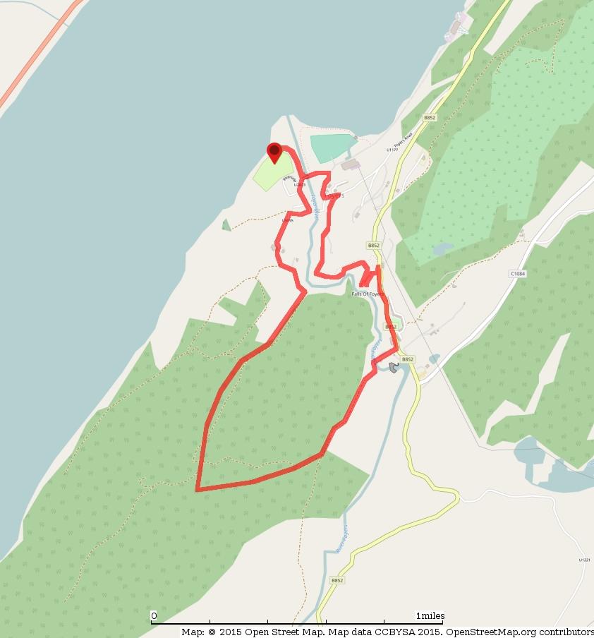
1 Loch Ness Shores Club Site Camping and Caravanning Falls of Foyers Route Summary A strenuous walk from Loch Ness Shores Club Site. The route climbs through forest to The Upper Foyers Waterfall and then continues through Upper Foyers to a shop/café. A delightful path then descends back to Lower Foyers past the Lower waterfall and an impressive gorge. Route Overview Category: Walking Length: km / 3.84 mi Last Modified: 29th June 2017 Difficulty: Medium Rating: Unrated Surface: Rough Date Published: 19th June 2017 Description 1/7
2 THE FALLS OF FOYERS ABOVE - LOWER FOYER FALLS From reception at Loch Ness Shores Club Site exit the site past the barrier. Drop down and curve right on the approach road passing beneath the campsite back into Lower Foyers. Continue ahead when the track becomes a lane and walk past a phone box to a bus stop. Go left continuing up a road with a forest to the left and houses right. When the road bends right go ahead into the woods curving right and rising beneath houses. Rise to go ahead on an access track. Curve left and right and go left at the next junction past a sign for 'Foyers Mains'. Pass through a gate/opening and follow the track to rise and curve left past a seemingly derelict house. Curve right in front of a white house and pass the side of the derelict house. Curve left on the track passing Merther Mains House. Stay ahead at a junction left by the house and continue towards the forest ahead to pass through a large gate to reach the forest. 2/7


3 ABOVE - THE TRACK AFTER ENTERING THE FOREST Take The Yellow Route ahead curving right past a marker. Rise on the track into the forest and stay ahead on the marked Yellow Route at a junction right. Climb upward near telegraph poles and overhead wires and higher up climb more steeply keeping to the track. Curve left with the track past a Yellow Route marker and reach a junction right as the angle eases. Stay ahead to descend past a Yellow Route marker and continue descending to reach more level ground at another junction marked with a Yellow Route post and a Red/Yellow Route post. Go left past the Red/Yellow route post and pass through a large deer gate. Follow the track on the forest edge with a fence right. Continue on the track to eventually curve right over a bridge by Upper Foyer Falls. ABOVE - UPPER FOYER FALLS After the bridge the track becomes surfaced and you follow it into Upper Foyers. Rise to a road and go left on the sidewalk following signs for 'Foyers Store' and 'Waterfalls Café'. Follow the road past a play area and houses right and descend to reach the entrance (left) for The Lower Falls of Foyers facing The Waterfalls Café, Village Store and a car park. 3/7


4 ABOVE - THE ENTRANCE TO THE LOWER FALLS OF FOYERS ABOVE THE WATERFALLS CAFE AND GENERAL STORE Go left through the left of two gates to follow signs for The Falls of Foyers and descend steps to a path junction. Go left for 'Falls of Foyers' and descend more steps to another junction where the path cuts back right. Go ahead to reach the upper viewpoint for the falls. Return to the main path and go ahead on it to drop down and cut back left to the lower viewpoint. 4/7
. Here leave your outbound route and stay ahead following signs for 'To Path Network' and 'Lower Foyers'.")
5 ABOVE - THE WAY TO THE LOWER FALLS OF FOYERS ABOVE - THE LOWER FOYERS WATERFALL Re-trace your steps back up past the upper viewpoint and continue up to the path junction passed earlier (where the path curves back right). Here leave your outbound route and stay ahead following signs for 'To Path Network' and 'Lower Foyers'. Continue to cross a bridge and next go left on a good path at a junction of paths. Cross a bridge and head downhill. At the next junction stay ahead on the 'Blue' path. Keep a fence left and follow the path zig-zagging down with a gorge on the left. Descend steps and pass a bench that overlooks the falls continuing to curve back right and pick up more descending steps. Continue down with the fence still left using a footpath and steps where available. ABOVE THE WAY BACK TO LOWER FOYERS When the path curves right it becomes more level before rising again to pass a nice viewpoint for the two bridges in Lower Foyers. 5/7


6 ABOVE - THE VIEWPOINT FOR THE TWO BRIDGE IN LOWER FOYERS Follow the path to reach a surfaced lane and go left on it to descend through trees to reach a road. Go left downhill on the road. Continue descending to curve left by a sign for the power station. Descend into Lower Foyers to cross a bridge over the river. Here go right on your outbound route to follow the road and then an access track back to the Club Site near Loch Ness. ABOVE THE WAY BACK TO THE CLUB SITE Waypoints 6/7
7 7/7
Bakewell Club Site - Robin Hood's Stride
 Bakewell Club Site - Robin Hood's Stride Camping and Caravanning Route Summary A circular walk with fabulous views winding it's way through the beautiful White Peak scenery. Points of interest include
HARDMOORS 26.2 WHITE HORSE HALF ROUTE DESCRIPTION - 018
 HARDMOORS 26.2 WHITE HORSE HALF ROUTE DESCRIPTION - 018 Follow Cleveland Way, keeping to the left hand path (right path is a bike trail) Ignoring any turnings to the left or right At path junction (after
RILLINGTON TO MALTON by Tania Dickinson
 RILLINGTON TO MALTON by Tania Dickinson This walk takes you from the Vale of Pickering up on to the Wold scarp, before dropping down again through the pretty village of Settrington and joining the Centenary
LDWA SOUTH DOWNS MARATHON 13 th MAY 2018
 AHD ahead SDW South Downs Way BL/BR bear left/bear right TL/TR turn left/turn right X cross LEG 1 - EAST DEAN to WP1 NORTON GR 470019. Open 1030 to 1300. 9.7 miles. 1.1 From village hall TL and walk to
LDWA SOUTH DOWNS MARATHON
 AHD ahead SDW South Downs Way BL/BR bear left/bear right TL/TR turn left/turn right SP signpost/fingerpost X cross LEG 1 - EAST DEAN to WP1 NORTON GR 470019. Open 1030 to 1300. 9.6 miles. 1.1 From village
The North Pennines from near Langwathby
 3.6 Langwathby to Armathwaite Map panel?? Distance 12.7 miles (20.5 km) Terrain farm, woodland and riverside paths; some potentially muddy tracks; a few short sections of road Grade gently undulating Food
Danbury Words and pictures by Laurie Page of the Public Rights of Way team at Essex County Council.
 Danbury Words and pictures by Laurie Page of the Public Rights of Way team at Essex County Council. An undulating walk from Danbury village to the bluebells at the National Trust property of Blakes Wood.
YHA RAVENSTOR Ideas for walks in the local area
 YHA RAVENSTOR Ideas for walks in the local area How to use this book This book contains some suggestions for enjoyable walks in the countryside immediately surrounding YHA Ravenstor. We hope that our guests
COSTA BLANCA MOUNTAIN WALKERS - WALK DESCRIPTION. Visit for more walks descriptions in Spain
 COSTA BLANCA MOUNTAIN WALKERS - WALK DESCRIPTION Visit www.walksinspain.org for more walks descriptions in Spain Walk description originally prepared by:- Ralph Phipps Last Updated 18 th April 2015 Title
Tenerife Sur: Short Walks Under 10 km. Santiago del Teide Almond Blossom
 Tenerife Sur: Short Walks Under 10 km Santiago del Teide Almond Blossom Route Summary This delightful circular walk is especially beautiful when the almond trees are in flower during January and February
Winterfold Wood. point your feet on a new path. In Brief
 point your feet on a new path Winterfold Wood Distance: 8½ km=5¼ miles Region: Surrey Author: Schwebefuss Refreshments: Windmill Inn, Peaslake after the walk moderate walking with many gradients Date written:
Welsh Newton and Woodland
 Welsh Newton and Woodland This is a 8.2km miles (approx) walk which will take about 2.5 hours at a relaxed and leisurely pace. There are a few hills but no steep inclines. Start at Llangrove bus stop and
The Mendip Way. Route Directions and Maps Wells to Frome
 The Mendip Way Route Directions and Maps Wells to Frome Website: www.mendiphillsaonb.org.uk Email: mendip@mendiphillsaonb.org.uk Facebook & Twitter: @MendipHillsAONB Phone: 01761462338 1 Wells to Shepton
Walking Pembrokeshire.
 Walking Pembrokeshire Canaston Woods Walk It s good to walk, so why not step out and sample some of the walks your neighbourhood has to offer. This pleasant and interesting walk which starts and finishes
Approximate distance: 5.5 miles For this walk we ve included OS grid references should you wish to use them. Start. End
 Approximate distance: 5.5 miles For this walk we ve included OS grid references should you wish to use them. End 4 1 Start 3 2 N W E S Reproduced by permission of Ordnance Survey on behalf of HMSO. Crown
Husthwaite to Byland Abbey
 Husthwaite to Byland Abbey This walk begins with a loop round the village of Husthwaite and continues towards Coxwold along a disused railway line, which is now a right of way. It passes through Coxwold
Distance: 9½ km=5¾ miles moderate walking or two walks of 4¼ km=2¾ miles and 6½ km=4 miles
 point your feet on a new path White Hill, Headley Distance: 9½ km=5¾ miles moderate walking or two walks of 4¼ km=2¾ miles and 6½ km=4 miles Region: Surrey Author: Fusszweig Refreshments: Headley Date
Falls Lake Trail (A part of the NC Mountains-to-Sea Trail) East to West
 East to West") Falls Lake Trail (A part of the NC Mountains-to-Sea Trail) East to West Section 1 (Falls of the Neuse Rd to Raven Ridge Rd) 0.0 mi Parking area of the Tailrace Fishing Area, just below the dam, off Falls
Falls Lake Trail (A part of the NC Mountains-to-Sea Trail) East to West Section 1 (Falls of the Neuse Rd to Raven Ridge Rd) 0.0 mi Parking area of the Tailrace Fishing Area, just below the dam, off Falls
Callicoma Loop. 174m. 98m. 2 hrs. Hard track 5.1 km Circuit. 153m
 Callicoma Loop 2 hrs Hard track 5.1 km Circuit 153m This great circuit walk passes through some really nice forest around the fringe of Cherrybrook. Highlights of the walk include some beautiful rock overhangs
Follow the Lantern Way clockwise from Dursley Town Hall through Cam & Coaley to Uley and back to Dursley (about 14 miles)
") According to the Rev Kilvert's diary of 1873, couples on their way to evening services in winter followed a practical though unusual local tradition: "My Mother says that at Dursley, when ladies and gentlemen
According to the Rev Kilvert's diary of 1873, couples on their way to evening services in winter followed a practical though unusual local tradition: "My Mother says that at Dursley, when ladies and gentlemen
Green Point Circuit Walk
 Green Point Circuit Walk 3 hrs 7.7 km Circuit Hard track 269m This walk visits all of the popular locations in Green Point Reserve, as well as some of the lesser-visited areas inland. Taking in Sea Eagle
THE BECK STONE Backstone Beck on Ilkley Moor
 THE BECK STONE Backstone Beck on Ilkley Moor 1 Three different routes which take in the best of the lower slopes of Ilkley Moor, with bracken, heather, a tarn (a small mountain lake) and rushing streams.
Falls Lake Trail (A part of the NC Mountains-to-Sea Trail) East to West
 East to West") Falls Lake Trail (A part of the NC Mountains-to-Sea Trail) East to West Section 1 (Falls of the Neuse Rd to Raven Ridge Rd) 0.0 mi Parking area of the Tailrace Fishing Area, just below the dam, off Falls
Falls Lake Trail (A part of the NC Mountains-to-Sea Trail) East to West Section 1 (Falls of the Neuse Rd to Raven Ridge Rd) 0.0 mi Parking area of the Tailrace Fishing Area, just below the dam, off Falls
THE PONTON PLOD - 27 MILE ROUTE
 THE PONTON PLOD - 27 MILE ROUTE Emergency Phone Number 07771 813514 Abbreviations: BW Bridleway X Cross immd immediately FP Footpath TL Turn left L Left thro through KG Kissing Gate TR Turn right R Right
This walk description is from happyhiker.co.uk
 This walk description is from happyhiker.co.uk Pendle Hill Walk From Barley Starting point and OS Grid reference Ordnance Survey map Distance Traffic light rating Barley village honesty box car park OS
VELINDRE VALLEYS WALK FOR STEFFAN
 VELINDRE VALLEYS WALK FOR STEFFAN IMPORTANT INFORMATION FOR WALKERS AND MARSHALS 1 Table of Contents Key Contact Numbers:... 3 Timetable and locations... 4 T-shirts... 4 Important Advice for Walkers...
Approximate distance: 10 miles For this walk we ve included OS grid references should you wish to use them. Start. End
 Approximate distance: 10 miles For this walk we ve included OS grid references should you wish to use them. 2 3 Start End 1 N W E S Reproduced by permission of Ordnance Survey on behalf of HMSO. Crown
Rail to River Walk. 3 hrs. Hard track 7.5 km Circuit. 222m
 Rail to River Walk 3 hrs Hard track 7.5 km Circuit 4 222m This walk is a great one from Chatswood Station to the Lane Cove River National Park. The walk descends through the vegetated bushland which fills
Christchurch to Hengistbury Head
 Last checked 6 June 2018 Document last updated: 13 July 2018 This document and information herein are copyrighted to Saturday Walkers Club. If you are interested in printing or displaying any of this material,
Hornsby Blue Gum Walk
 Hornsby Blue Gum Walk 3 hrs Hard track 6.7 km Circuit 4 374m This delightful loop is one of the prettiest and most popular walks in the Hornsby area. Going from an environment of ferns and clear bushland
Follow the road to Figueira and once there turn left at the road junction. 30 Minutes
 Follow the road to Figueira and once there turn left at the road junction. 30 Minutes Continue along this road, before the bridge turn right into Largo 1 st Maio and keeping left turn into Rua do Meia
Waterfall to Heathcote
 Waterfall to Heathcote 5 hrs Hard track 10.8 km One way 4 467m This walk explores the heart of Heathcote National Park, and is easily accessed with a train station at either end. Although relatively close
Hexham Abbey to the Racecourse Road
 Hexham Abbey to the Racecourse Road The Yarridge Road, or Racecourse Road as it is often known, runs along the ridge line to the south of Hexham and provides wonderful views of the river valley and fells
THE WELLDIGGERS ARMS, HESWORTH AND FITTLEWORTH TRAIL
 THE WELLDIGGERS ARMS, HESWORTH AND FITTLEWORTH TRAIL 5.5 miles Circular 3 hours 041017 Challenging Terrain A 300-year-old pub turned country-inn on the edge of the South Downs National Park, The Welldiggers
Hascombe and Winkworth Arboretum Downs Link Path, Smithbrook Kilns
 point your feet on a new path Hascombe and Winkworth Arboretum Downs Link Path, Smithbrook Kilns Distance: 18 km=11 miles Region: Surrey Author: RDC easy walking Date written: 7-may-2016 Last update: 30-aug-2018
Hammer Vale and Linchmere Common
 point your feet on a new path Hammer Vale and Linchmere Common Distance: 9 km=5½ miles or 6 km=3¾ miles easy walking with one steep section Region: Hampshire, West Sussex Author: Botafuego Refreshments:
Wentworth Falls Conservation Hut Loop
 Wentworth Falls Conservation Hut Loop 3 hrs Hard track 6.7 km Circuit 4 341m This scenic walk from Wentworth Falls Station, winds along the Nature Trail to Conservation Hut, then drops into the magnificent
NEWLANDS CORNER AND ST MARTHAS
 NEWLANDS CORNER AND ST MARTHAS 10k CIRCULAR ROUTE 2½-3HRS GU4 8SE From Newlands Corner on the North Downs just outside Guildford, you can enjoy one of the most beautiful panoramas of quintessential English
Dorridge & District Residents Association A Walk Along The Green Belt From Dorridge to Catherine-de-Barnes
 Dorridge & District Residents Association A Walk Along The Green Belt From Dorridge to Carine-de-Barnes The starting section of this walk through open fields would be destroyed by building of motorway
Key Information. Self-Guided Walk Exploring Sedbergh
 Self-Guided Walk Exploring Sedbergh A great short walk - ideal for an early evening in summer. This is a lovely circuit of Sedbergh visiting some of the historic buildings as well as ambling by the river
Walks Around Bishopstone & Hinton Parva
 The Walks: From ½ mile ambles to 8 mile scenic loops Hinton Parva Walks H1 H2 H3 Bishopstone Walks B1 B2 B3 B4 B5 Walk B1: Bishopstone Village, The Dingle (stream) & Pond A short circular village amble
No. 1 By River Ribble & Brungerley Park 3¼ Miles,
 RVRNEWS 102 No. 1 By River Ribble & Brungerley Park 3¼ Miles, Approx 2 Hours This walk starts at the gate on platform 2 of Clitheroe station. Leaving the station turn left making towards Kirkmoor Rd and
Coyote Buttes/The Waves
 Coyote Buttes/The Waves Ron Ross December 22, 2007 Coyote Buttes is located in the Paria Canyon-Vermilion Cliffs Wilderness just south of US 89 about halfway between Kanab, Utah and Page, Arizona. The
Carrington Park to Leura Forest and pass loop
 Carrington Park to Leura Forest and pass loop 3 hrs Hard track 4.8 km Circuit 4 674m This walk is a fantastic way to see Leura Forest. The walk descends from Carrington Park, visiting Leura Forest and
About The Big Bend Open Road Race U.S 285 Course Notes
 2018 About The Big Bend Open Road Race U.S 285 Course Notes Course notes for 2018, Ft. Stockton to Sanderson and return. * Please note that these course notes are based on the 2017 race. You will notice
Slindon Folly - South Downs, West Sussex
 Slindon Folly - South Downs, West Sussex Starts at Park road-side near entrance to Slindon College 2 hours 15 minutes 4.5miles 7.2km Easy ID: 0.1598 Developed by: Chris Mumford Checked by: Rockpit www.ramblersroutes.org
Green Man Ultra Route Directions 2018
 Green Man Ultra Route Directions 2018 Start-CP1 (9 miles) Community Forest Path (CFP) Frome Valley Way (FVW) From the starting line cross the playing fields diagonally to the metal gates in the hedge lined
Route: Skewsby Foulrice Stearsby
 Route: Skewsby Foulrice Stearsby Distance: 7 miles Map: Explorer: 300 Howardian Hills & Malton Start (OS ref): SE625710 Park in the village of Skewsby. Walk east out of the village to the T-Junction and
NETTLESTEAD & YALDING
 NETTLESTEAD & YALDING ULL CIRCUIT - Sheet 1 (first and last sections) Open fields (see 'Introductory Notes') 88 Direction label (as in the walk notes) ROADS: 81 10m Significant roads Redhill arm North
Distance: 14 km=8½ miles or 7 km=4½ miles easy-to-moderate walking
 point your feet on a new path Normandy Distance: 14 km=8½ miles or 7 km=4½ miles easy-to-moderate walking Region: Surrey Author: Botafuego Refreshments: Pirbright, Ash date written: 20-feb-2012 date revised:
Detailed Descriptions and Maps of Woodside s Nature Trails
 Detailed Descriptions and Maps of Woodside s Nature Trails Access Mill Road Trail Park along Anderson Mill road. Signs on West Pleasant Colony and Anderson Mill road clearly point to the beginning of the
Clyde Walkway Community Links: Crossford Stonebyres Nemphlar- Kirkfieldbank
 Clyde Walkway Community Links: Crossford Stonebyres Nemphlar- Kirkfieldbank Crossford Stonebyres Nemphlar - Kirkfieldbank Digital Trail Difficulty (out of 3) 2 Distance 1. Crossford to Kirkfield Bank Bridge
WETHERBY CIRCULAR by Tania Dickinson
 WETHERBY CIRCULAR by Tania Dickinson This walk in lower Wharfedale includes a disused railway line at the beginning and riverside at the end, with parkland, fields, woodland and villages in between. Distance
THE CONNEMARA LOOP COASTAL TRAILS.
 THE CONNEMARA LOOP COASTAL TRAILS When walking would you please respect the countryside and... Bring back all your own rubbish Take care of the flora and fauna in the area Please respect the land, the
Echo Point to Leura Forest via Three Sisters and Giant Stairs loop
 Echo Point to Leura Forest via Three Sisters and Giant Stairs loop 3 hrs 3.8 km Circuit Hard track 512m This walk starts from the popular Echo Point, in Katoomba, and winds down to the base of the Three
Hindleap and Vachery Ashdown Forest, Chelwood Gate, Forest Row
 point your feet on a new path Hindleap and Vachery Ashdown Forest, Chelwood Gate, Forest Row Distance: 5 km=9½ miles Region: East Sussex Author: Stivaletti Refreshments: Chelwood Gate, Forest Row Map:
Cilgerran Wildlife Park Circular Walk
 Walking embrokeshire Cilgerran Wildlife ark Circular Walk It s good to walk, so why not step out and sample some of the walks your neighbourhood has to offer. This pleasant and interesting walk which starts
Masson Hill. Walk. Approximately 4 km. Moderate Walk Begins from Matlock Railway Station
 Masson Hill Walk Approximately 4 km Moderate Walk Begins from Matlock Railway Station TOWN WALKS Masson Hill walk is approx. 4 km. It can be walked in a couple of hours or so. Enjoy your walk and the beautiful
Dyrham and Hinton Parish Walks
 Dyrham and Hinton Parish Walks A series of five walks in the parish, exploring most of the public footpaths. By John Miller Each walk is described in detail, with a complete map, to provide a handy guide
Beautiful Walks from the Blue Ball Inn
 Walk No. 7 COAST AND VALLEY WALK Countisbury, Glenthorne, County Gate, Brendon, Rockford and Wilsham 10 MILES APPROX. Walking time 5 hours approx. (not including breaks)> OS Sheet 64/74 Lynton and Lynmouth.
Distance: 15 km=9 miles, with 2 optional diversions 1-2 km each easy walking
 point your feet on a new path Hascombe from Afar Distance: 15 km=9 miles, with 2 optional diversions 1-2 km each easy walking Region: Surrey Author: Schwebefuss Refreshments: Hascombe Date written: 9-may-2010
Popes Glen, Pulpit Rock, Govetts Leap and Braeside Walk
 Popes Glen, Pulpit Rock, Govetts Leap and Braeside Walk 8 hrs Hard track 13.6 km Circuit 4 1068m This large circuit walk, from Popes Glen to Pulpit Rock, Govetts leap and along the Braeside Track, passes
SUMMER WALK 10. The Chairmakers, Worlds End
 SUMMER WALK 10 The Chairmakers, Worlds End Tuesday 10 th June 7.30pm This is a very short walk made so due to the majority of the footpaths in the area around the Chairmakers being overrun with high nettles
Tideswell to Castleton
 Tideswell to Castleton 1 Walk summary Length: 14 km, 8.5 miles Maps: OS Explorer OL1 The Peak District - Dark Peak Area, OS Explorer OL24 The Peak District - White Peak Area, OS Landranger 110 Sheffield
Shere Heath and the Hurtwood
 point your feet on a new path Shere Heath and the Hurtwood Distance: 15¾ km=9¾ miles Region: Surrey Author: Schwebefuss Refreshments: Little London moderate-to-easy walking Date written:10-jul-2009 Date
VERN S CAMP from Minginui
 VERN S CAMP from Minginui Map: Kuratau, 1:50,000 V18 Refer Figures 1, 3, 4 and 5 GPS: Geodetic Datum 1949 Refer Figure 10a (Geographic) and 10b (NZ Grid) How to get to START: From the police station on
Shepherdswell - Dover
 Shepherdswell - Dover The North Downs Way > Shepherdswell to Dover Introduction This part of the path is slightly different in character from most other parts of the path since it spends much of the time
The Foreshore Walk. 24m. 1m Lake Macquarie LGA. 1 hr 15 mins 2.9 km One way. Hard track 81m
 The Foreshore Walk 1 hr 15 mins 2.9 km One way Hard track 81m This walk traverses the coastline of the Green Point reserve. By following a variety of tracks and occasionally traveling inland through eucalyptus
Clyde Walkway Community Links: Rosebank Circular via Ashgill and Dalserf
 Clyde Walkway Community Links: Rosebank Circular via Ashgill and Dalserf Rosebank Circular via Ashgill and Dalserf Digital Trail Difficulty (out of 3) 1 Distance 7 km / 4.35 miles. Time 2 hours Terrain
Direction to the Department of Linguistics, Seoul National University
 Page 1/8 Direction to the Department of Linguistics, Seoul National University 1. From Incheon Airport by Airport Limousine (Click here for the detailed information) [Highly Recommended] Take #6017 Airport
For more information and to buy this book click here ISBN: CICERONE. Guides for walkers, trekkers, mountaineers, climbers and cyclists
 For more information and to buy this book click here ISBN: 9781852845377 CICERONE Guides for walkers, trekkers, mountaineers, climbers and cyclists www.cicerone.co.uk WALK 5 Ouston and Urpeth Distance
A mainly flat walk along the Peak Forest Canal to Castle Hill and returning along the River Tame via Hulmes Wood and Haughton Dale.
 Walk 9 Haughton Green, Peak Forest Canal, Castle Hill, Hulmes Wood, River Tame, Haughton Dale Circular Miles: 3.9 Time: 1 Hour 30 Minutes Grade: Easy To Moderate Starting Point: Junction Of Gibraltar Lane/Newport
Bagshot Heath and Swinley Forest
 point your feet on a new path Bagshot Heath and Swinley Forest Distance: 13 km=8 miles Region: Berkshire, Surrey Author: Botafuego Refreshments: Forest Look Out, Bagshot easy walking Date written: 17-feb-2013
GENERAL INFORMATION PLEASE FOLLOW THE COUNTRYSIDE CODE:
 KNIGHTON CIRCULAR WALKS The East Radnor Group of the Ramblers Association invites you to enjoy these walks around Knighton. Knighton is an excellent centre for walks in the lovely unspoilt mid-wales countryside
Katoomba Falls Circuit
 Katoomba Falls Circuit hr 5 mins.5 km Circuit Hard track 59m For those looking for a walk involving more than simple boardwalk, this trail winding through the temperate rain forest could be just the thing.
WALK 1 - SHRIGLEY HALL THE NAB LENGTH: 2.5 MILES. GRADIENT: CHALLENGING. STOUT FOOTWEAR REQUIRED
 SIX WALKS FROM SHRIGLEY HALL HOTEL COLLECT A COPY FROM HOTEL RECEPTION 1 (PLEASE NOTE, WALKING AROUND OR ACROSS THE GOLF COURSE IS NOT PERMITTED) WALK 1 - SHRIGLEY HALL THE NAB LENGTH: 2.5 MILES. GRADIENT:
Oldbury & Littleton, South Gloucestershire
 Oldbury & Littleton, South Gloucestershire Starts at Church Lane, Oldbury. BS35 1QF 2 hours 0 minutes 5.2miles 8.4km Easy ID: 0.2468 Developed by: GEOFF MULLETT Checked by: Marion Stone www.ramblersroutes.org
SIX WALKS FROM SHRIGLEY HALL HOTEL COLLECT A COPY FROM HOTEL RECEPTION (PLEASE NOTE, WALKING AROUND OR ACROSS THE GOLF COURSE IS NOT PERMITTED)
") SIX WALKS FROM SHRIGLEY HALL HOTEL COLLECT A COPY FROM HOTEL RECEPTION (PLEASE NOTE, WALKING AROUND OR ACROSS THE GOLF COURSE IS NOT PERMITTED) SH WALK 1 - SHRIGLEY HALL THE NAB LENTH: 2.5 MILES. GRADIENT:
SIX WALKS FROM SHRIGLEY HALL HOTEL COLLECT A COPY FROM HOTEL RECEPTION (PLEASE NOTE, WALKING AROUND OR ACROSS THE GOLF COURSE IS NOT PERMITTED) SH WALK 1 - SHRIGLEY HALL THE NAB LENTH: 2.5 MILES. GRADIENT:
Parks, green routes, river, churches, heath, views, historic town
 point your feet on a new path Hendon to Distance: 8½ km=5½ miles Region: Greater London Author: Thwelder Refreshments: Hendon, Map: Explorer 173 (London North) or A-Z, both optional easy walking Date written:
Pull the gate towards you and ride through. The third gate takes you onto Hound House Road. Watch out for traffic. 4
 PEASLAKE TO FARLEY HEATH AND WINTERFOLD 12k CIRCULAR ROUTE 2HRS GU5 9QW This interesting trail takes you across a variety of terrain, from the sandstone of Pitch Hill, across open farmland with fabulous
Puttenham and the Welcome Woods
 point your feet on a new path and the Welcome Woods Distance: 15 km=9 miles easy walking or 2 shorter walks of 5½ km=3 miles and 12½ km=7½ miles Region: Surrey Author: Schwebefuss Refreshments: or picnic
Walk 2: doniford to east quantoxhead
 Walk 2: doniford to east quantoxhead Length: 9 ¼ miles / 15km Good For: Difficulty: Moderate Theme: Nature Notes: This walk is tidal - please check tide times before setting off. Dogs are welcome but need
How to get there. Respect - Protect - Enjoy
 How to get there Driving: Postcode is RG9 5PF and there is a car park just across from the pub. Nearest station: Henley-on-Thames station is 5.6 miles away. We re delighted to present three circular walks
Guildford to Gomshall
 Morning last checked Afternoon last checked Option c) last checked Option d) last checked 9 April 2016 9 April 2016 9 April 2016 23 December 2017 Document last updated: 4 May 2018 This document and information
Heathcote to Engadine via Audley
 Heathcote to Engadine via Audley 6 hrs 3 mins 5 km One way Hard track 4 635m Covering a large section of central Royal National Park, this walk goes through the heath and scrub along a well managed and
The Hundred Parishes
 The Hundred Parishes Walks from railway stations number 9 6.4 miles (10kms) from Bishop s Stortford to Stansted Mountfitchet Start: Bishop s Stortford station (Grid Reference TL492209) (ample parking and
Walk 7: Watchet to washford
 Walk 7: Watchet to washford Length: Moderate - 7.5 miles / 12 km Good For: Theme: History Duration: 2-3 hours depending on speed of walking Notes: This is a moderate to difficult walk in places, with steps,
Govetts Leap Loop. 1065m. 909m Blue Mountains National Park. 4 hrs 30 mins 8.7 km Circuit. Hard track 380m
 Govetts Leap Loop 4 hrs 30 mins 8.7 km Circuit Hard track 380m This walk, from Blackheath Train Station, is a fantastic way to see some of the iconic areas of the Blue Mountains in the Blackheath area.
Parking. Signing. Appendix C Typical detail drawings. London Cycling Design Standards
 Appendix C Typical detail drawings London Cycling Design Standards All drawings are prefixed CCE/ General A1 Cycle Symbol Diagram 1057 165 A3 Raised entry treatment on side roads 166 A4 Raised table at
North Ryde Fairyland circuit
 North Ryde Fairyland circuit 2 hrs 30 mins Hard track 6.9 km Circuit 193m 4 Starting at North Ryde train station this walk explores a stretch of the Lane Cove River, visiting the historic Fairlylands Pleasure
Murlough. Dunes open access, some restricted areas Woodland open access, some restricted areas
 A2 Belfast Road Dundrum Murlough P3 N Dundrum Bay boathouse Ballykinler MOD Firing Range P4 P5 Downshire Bridge inlet floods at high tide Murlough Farm Private PNT Murlough House Private Seals agricultural
Waterhead Pier to Orrest Head, Windermere and Bowness
 Waterhead Pier to Orrest Head, Windermere and Bowness A 4 1 2 hour walk through Woodlands and the Troutbeck Valley with spectacular Lake and Mountain views and a lakeshore path. Walk 10 Walk 11 Walk 12
Stokenchurch. Bluebell Woods, Bomber Memorial, Red Kites, Getty s Cricket Ground, Nature Reserve
 Stokenchurch Bluebell Woods, Bomber Memorial, Red Kites, Getty s Cricket Ground, Nature Reserve Bomber Memorial The best time to visit Cowleaze Wood is in the spring when there is a memorable display of
How to get there. Respect - Protect - Enjoy
 How to get there Driving: Postcode is OX10 6AD with a car park for customers. Nearest station: Goring & Streatley station is 5.6 miles away. We re delighted to present three circular walks all starting
Although the majority of these walks are around country lanes you should still follow the Country Code:-
 With the update of the Parish Plan was a request for details of any Walks around Pillaton The following pages give several walks that I and my wife have done for many years. Please be aware that NONE OF
ST. AGNES. you cannot put a time limit on beauty.
 ST. AGNES CIRCULAR WALKS AROUND There are many enjoyable and picturesque walks around St. Agnes most are signposted and are featured on the St. Agnes Mini-guide map. Because most of our footpaths are in
Do more cycling. EIGHT CYCLE ROUTES AROUND dornoch
 Do more cycling EIGHT CYCLE ROUTES AROUND dornoch cycle routes Around dornoch route 1 Loch Fleet 12.5 miles Easy Description: Route 1 takes you past the fishing village of Embo and to Loch Fleet, an internationally-renowned
Traffic signs used, including signs giving orders, warning signs, direction signs, information signs and road works signs.
 Traffic signs Traffic signs used, including signs giving orders, warning signs, direction signs, information signs and road works signs. Although The Highway Code shows many of the signs commonly in use,
West Marden and Stansted Forest
 point your feet on a new path West Marden and Forest Distance: 3½ km=8½ miles easy walking with optional ½ km=½ miles extension to Rowlands Region: West Sussex Author: Hautboy Refreshments: West Marden,
Directions for Day 1: Colwood To Metchosin
 Colwood-Metchosin Page 1 of 8 Directions for Day 1: Colwood To Metchosin Start: Royal Roads University, Birds of a Feather B&B, or at Esquimalt Lagoon Finish: Your accommodation in Metchosin Time: 4-5