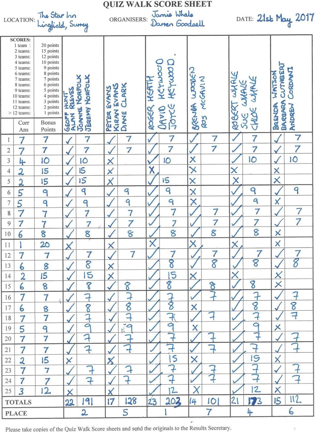
Meridian Meander Sunday 21st May 2017 Start: 2.15pm The Star Inn Church Road, Lingfield, Surrey RH7 6AH
|
|
|
- Berenice Jefferson
- 5 years ago
- Views:
Transcription


1 Jamie Whale and Darren Goodsell present Meridian Meander Sunday 21st May 2017 Start: 2.15pm The Star Inn Church Road, Lingfield, Surrey RH7 6AH The Walk: A 4 mile walk from this large pub in Lingfield. The route is a mixture of footpaths, lanes, tracks and roads. There are seven stiles. The Venue: The Star Inn is a large pub serving a range of meals. Lighter bites are also available. Sunday roasts are to and your organisers can confirm it is of a high standard! Though large, the pub is very popular and busy on Sundays, so if you wish to eat we recommend booking a table. The pub has its own car park, but we recommend Quiz Walkers coming by car park on the quiet surrounding streets out of courtesy for the pub. Tel. no.: Website: OS Grid Reference: TQ
2 Directions: From M25: Leave M25 J6 take A22 south, avoiding Godstone. At the roundabout with the A25, keep ahead on A22. Pass through Bletchingley and South Godstone, eventually reaching Blindley Heath. Turn left on to the B2029, which takes you to Lingfield. Straight ahead at the first mini-roundabout, then left at the second on to the B2028. Pass the shops, and as you start to go downhill turn left into Church Lane. The pub is 100yds on the right. The pub does have a car park but we recommend parking on the road to save space for other customers. Public Transport: The pub is a short walk from Lingfield National Rail station, which is on the East Grinstead line. On Sundays, Lingfield has two trains per hour, leaving London Victoria at xx23 and xx53 and East Croydon at xx40 and xx10. Journey time of approximately 30mins from East Croydon. Note that new timetables come into operation on Sunday 21st May. From the station approach road, look for a public footpath almost directly opposite, to the right of a large stone building. The pub is a 5min walk at the other end of this path. No engineering works are listed for this route on Sunday 21st May.
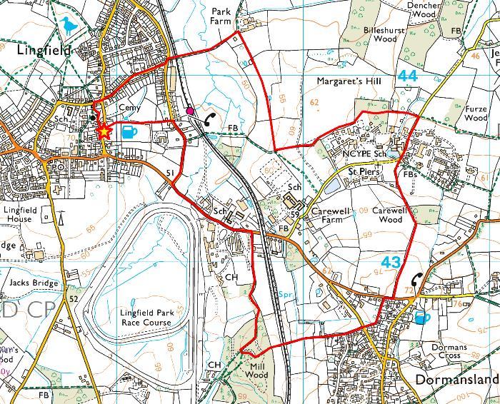
3 Route Map

4 Jamie Whale and Darren Goodsell present Meridian Meander The Star Inn Lingfield Surrey RH7 6AH Sunday 21st May 2017, 2.15pm tel: Starter Clues All clues are on the pub building, visible from the car park. 1. With your deerstalker hat, step in. A room, refreshment, and some gin? 2. A primary tool if someone s just dusted: Boots (or shoes) make each room encrusted. 3. The security here Could be yankee beer. Stage 1 Exit the pub car park by the right-hand exit, turn half-right and walk towards the church spire, passing between old buildings. Proceed into the churchyard (there are no answers on gravestones), bear right and then left to pass around the side of the church, then go across the cemetery towards a timbered building. Bear right, go down the steps in front of this building to emerge on a road. Turn right, then at the crossroads go straight across into Bakers Lane. Cross to the pavement on the left hand side of the road. Walk the full length of this road, staying on the left pavement and ignoring side roads. Stage ends at the end of Bakers Lane. 4. Soldier, leader and man of the sea Meet to defend the literary. 5. Sussex town reduced to fraud By these two halves poorly restored. 6. Burglars begrudge A tiny smudge.
5 Stage 2 Cross over Station Road, turn left, then after just 15m turn right into a gravelled area partially guarded by a gate. Proceed ahead to railway crossing and cross the railway. Proceed ahead along farm track, ignoring paths to side, until eventually reaching farmyard. Turn right along a gravelled track, with a wall on your right hand side. When you reach a gate by some houses, go around the gate, proceed ahead across the field then continue on path to the right of a copse. At large tree and cross-paths, continue ahead in accordance with public footpath sign. At the edge of the field, but before you reach the gate ahead, turn left and proceed up the side of the field you have just traversed. In doing so, you will cross the Prime Meridian into the Eastern Hemisphere. Stage ends at the top of the hill. 7. Caution restored: A bull is scored. 8. With the software Paul hid There are faults in the grid. 9. Court game trebly stirred: Fruity home will be inferred. Stage 3 Proceed straight ahead, to the left of a hedge. Go along the edge of the field with woodland on your right. Ignore path on right by fallen tree and continue along the edge of the field. At the corner of the field, turn right into woodland at Public Footpath sign. Go through the double gate and immediately turn left. Follow the wide path into an activity area; proceed generally ahead ignoring crossing paths. Eventually reach a gate at the edge of the woodland. Go through the gate and over the stile into a field. Proceed ahead to a bridge. Cross the bridge, which has a small stile at each end, into another small field. Cross this field to another stile, where stage ends. 10. A legend? Your dad is, most of the way: He has some pointers for your team today. 11. Initially they might be lewd. Upside-down they re normally viewed. 12. As James Bond cannot be here, His colleague s presence is doubled, it s clear.
6 Stage 4 Go over stile, turn right and stay on the lane. You are passing through a residential school/hospital for children with special needs. Please respect their privacy: do not stray from the road or intrude in any way. After 250m, reach a small bridge beside a lake on the right. No clues on underlined section: bear half-left into first access road, then immediately right along asphalt footpath, then turn left into a car park. Go past a bin store, then immediately turn left to enter a wooded public footpath. Clues restart here. Proceed up the footpath, crossing a stile into a small field then another stile into a large field. Around 100m into this field, cross the stile beside the gate on the left into a very large field. Bear right and proceed up the right hand side of this field. Stage ends at kissing gate in the top corner of the field. 13. Matt went your way with perfect sight; Bert went yesterday, hidden by night. 14. Machine you can make With the littlest ache. 15. Has limited powers As it s open all hours. No clues on next short section: Go through kissing gate and turn right. Walk carefully along the right hand side of the road for about 30m. Cross over into signposted public footpath opposite. Stage 5 does not start until you have entered the footpath. Stage 5 Follow this path between garden fences, eventually to emerge on another road. Go straight across into West Street. Join the raised walkway on the left at the first access point, then proceed parallel to the road. When the road bends left, come off the walkway and continue ahead along West Street, which is now an unmade road. At the end of the lane, continue ahead on footpath to the left of SANDROCK. Stage ends immediately after a railway bridge, and you are now back in the Western Hemisphere. 16. A slam-dunk story Backed by Old Glory. 17. The name is funny: Like litter money. 18. A marathon wouldn t get you near, But another mile and you d be here.
7 Stage 6 Proceed ahead. Do not stray on to the golf course; be considerate to golfers playing their shots and watch out for golf balls! Keep to the well-made path, and after crossing two fairways you will reach a junction of bridleways. Turn right and follow this bridleway for some distance, eventually emerging by some houses on the right, with the racecourse on your left. Continue ahead to main road, where stage ends. 19. For an impartial road Where all your leads bode. 20. Line and path are intertwined; They seem to be an hour behind. 21. Anglers wait, but insects thrive; Marsh infesters are alive. Stage 7 Cross road and turn left, staying on the pavement. Stay on this road, past the racecourse entrances, and eventually, after crossing a stream, turn right into Station Road, remaining on the pavement. Proceed along Station Road. Just before the entrance to the railway station on the right, cross the road to enter a public footpath opposite, alongside a large stone building. Follow this path to return to the pub, where walk ends. 22. Looking back, said Sid and Ron, There was no money to be won. 23. Perhaps if they had magical powers They would produce some leathery flowers. 24. Beers, liquers and demi-sec All eschewed by the brandy rec. 25. Lastly, an alphabet test? Oh, you are not impressed. Spare clues On Stage 4: Spare A. Crazy how It s tilting now. Spare B. If you see your ox pant, He ll be glad it s extant.
8 Meridian Meander The Star Inn, Lingfield, Surrey, RH7 6AH Sunday 21st May 2017 Answers Q1. THE STAR EAT DRINK SLEEP on sign. Q2. BOSMERE on bootscraper. Initial letters of boots (or shoes) make each room encrusted. Q3. YALE on lock. Yankee = Y; beer = ale. Q4. Knight, Churchill and Admiral on alarm and security stickers on library building. Q5. HORSHAM embossed on drain covers, now rearranged as HOR and SHAM separately. Q6. MICROMARK on alarm. Q7. 50mph speed limit sign on railway. The bull is worth 50 points in darts. Q8. PAUWELS TRAFO on electricity substation. Anagram of software Paul. Q9. MULBERRY COTTAGE. Anagram of court game trebly. Q10. FOOTPATH on sign. Leg end = foot; your dad = pa; most of the = th. Q11. EYES WIDE DIGITAL LTD. Initial letters spell lewd when rearranged. Q on sign. 009 a colleague of 007. Q13. Two 20mph signs. Matt went your way and Bert went yesterday Q14. SELECTATILTH on old piece of farm machinery. Anagram of littlest ache. Q15. Gate on right, in middle of field, completely useless as no accompanying fence. Q16. Basketball hoop with Stars & Stripes backboard. Q17. CLUTTERBUCKS Gritting on salt/grit bin. Litter = clutter; money = bucks. Q18. 27m 09ch on signs on and just before railway bridge. Q19. Fairway. Initial letters of for an impartial road where all your and impartial road = fair way. Q20. GREENWICH MERIDIAN TRAIL and GMT on direction sign. Q21. FISHERMANS REST. Anagram of marsh infesters. Q22. NORDIS NO SCRAP VALUE on back of road signs. NORDIS is Sid Ron reversed. Q23. TANNERY GARDENS Q24. CYDER BARN. Anagram of brandy rec. Q25. IAE on gate. Vowels, with O and U missing. Sp. A. 2 TIN LING. Tilting now is anagram of Two Tin Ling. Sp. B. PAXTON on trough. Anagram of ox pant, whilst the ox would appreciate the water. Thank you for coming to Lingfield. We hope you enjoyed the walk. Jamie & Darren
9 Jamie Whale and Darren Goodsell present Meridian Meander Kids Clues The Star Inn Lingfield Surrey RH7 6AH Sunday 21st May 2017, 2.15pm tel: Starter Clues All clues are on the pub building, visible from the car park. 1 The group that can tell If you run the pub well. 2 Very right First light. Stage 1 Exit the pub car park by the right-hand exit, turn half-right and walk towards the church spire, passing between old buildings. Proceed into the churchyard (there are no answers on gravestones), bear right and then left to pass around the side of the church, then go across the cemetery towards a timbered building. Bear right, go down the steps in front of this building to emerge on a road. Turn right, then at the crossroads go straight across into Bakers Lane. Cross to the pavement on the left hand side of the road. Walk the full length of this road, staying on the left pavement and ignoring side roads. Stage ends at the end of Bakers Lane. 3 This creature of beef Rings out underneath. 4 Ensure your behaviour doesn t stray: You are on the reverend s way. 5 Here is set Evergreen octet.
10 Stage 2 Cross over Station Road, turn left, then after just 15m turn right into a gravelled area partially guarded by a gate. Proceed ahead to railway crossing and cross the railway. Proceed ahead along farm track, ignoring paths to side, until eventually reaching farmyard. Turn right along a gravelled track, with a wall on your right hand side. When you reach a gate by some houses, go around the gate, proceed ahead across the field then continue on path to the right of a copse. At large tree and cross-paths, continue ahead in accordance with public footpath sign. At the edge of the field, but before you reach the gate ahead, turn left and proceed up the side of the field you have just traversed. In doing so, you will cross the Prime Meridian into the Eastern Hemisphere. Stage ends at the top of the hill. 6 These feathered two Are tiled for you. 7 Better keep an eye out: This beast has considerable clout 8 Look hard: you might catch The game, set and match. Stage 3 Proceed straight ahead, to the left of a hedge. Go along the edge of the field with woodland on your right. Ignore path on right by fallen tree and continue along the edge of the field. At the corner of the field, turn right into woodland at Public Footpath sign. Go through the double gate and immediately turn left. Follow the wide path into an activity area; proceed generally ahead ignoring crossing paths. Eventually reach a gate at the edge of the woodland. Go through the gate and over the stile into a field. Proceed ahead to a bridge. Cross the bridge, which has a small stile at each end, into another small field. Cross this field to another stile, where stage ends. 9 You and I could cross this way. Cars? An impossibility. 10 Animals? Oh dear! Sounds like they re here 11 ensure there s no doubt That these can get out. Stage 4 Go over stile, turn right and stay on the lane. You are passing through a residential school/hospital for children with special needs. Please respect their privacy: do not stray from the road or intrude in any way. After 250m, reach a small bridge beside a lake on the right. No clues on underlined section: bear half-left into first access road, then immediately right along asphalt footpath, then turn left into a car park. Go past a bin store, then immediately turn left to enter a wooded public footpath. Clues restart here. Proceed up the footpath, crossing a stile into a small field then another stile into a large field. Around 100m into this field, cross the stile beside the gate on the left into a very large field. Bear right and proceed up the right hand side of this field. Stage ends at kissing gate in the top corner of the field. 12 The wind won t bend Our nutty friend. 13 Maybe it is power s child But being eaten by the wild.
11 No clues on next short section: Go through kissing gate and turn right. Walk carefully along the right hand side of the road for about 30m. Cross over into signposted public footpath opposite. Stage 5 does not start until you have entered the footpath. Stage 5 Follow this path between garden fences, eventually to emerge on another road. Go straight across into West Street. Join the raised walkway on the left at the first access point, then proceed parallel to the road. When the road bends left, come off the walkway and continue ahead along West Street, which is now an unmade road. At the end of the lane, continue ahead on footpath to the left of SANDROCK. Stage ends immediately after a railway bridge, and you are now back in the Western Hemisphere. 14 If your legs are numb From a generous run. 15 Dating this could be fun: Clearly different by 101. Stage 6 Proceed ahead. Do not stray on to the golf course; be considerate to golfers playing their shots and watch out for golf balls! Keep to the well-made path, and after crossing two fairways you will reach a junction of bridleways. Turn right and follow this bridleway for some distance, eventually emerging by some houses on the right, with the racecourse on your left. Continue ahead to main road, where stage ends. 16 Continue taking part From the silver medal start. 17 Security provided But why, unsighted. Stage 7 Cross road and turn left, staying on the pavement. Stay on this road, past the racecourse entrances, and eventually, after crossing a stream, turn right into Station Road, remaining on the pavement. Proceed along Station Road. Just before the entrance to the railway station on the right, cross the road to enter a public footpath opposite, alongside a large stone building. Follow this path to return to the pub, where walk ends. 18 A sign to give The place horses live. 19 The route is yours If you mix at stain door. 20 Certainly not pale: Could be blackmail.
. 6 Two birds on mosaic on house no. 99. 7 BULL IN FIELD on sign. 8 Tennis courts in garden on right.")
12 Meridian Meander The Star Inn, Lingfield, Surrey, RH7 6AH Sunday 21st May 2017 Kids Answers 1 British Institute of Innkeeping. 2 VR on light housings. V and R the first letters of Very right. 3 Cow with doorbell hanging from it. 4 VICARAGE ROAD 5 8 CONIFERS (house name). 6 Two birds on mosaic on house no BULL IN FIELD on sign. 8 Tennis courts in garden on right. 9 Wooden chain bridge. 10 ROE DEER. Sounds like oh dear. 11 Livestock in field. Please close the gate on sign. 12 Squirrel on weather vane. 13 WATSON on roller. Watt is unit of power; a son is a child; the roller is becoming overgrown. 14 Bench presented by the Lingfield Marathon House dated 1895 with extension dated 1996, 101 years later. 16 2nd TEE on sign. 17 SECURIT on padlock. Security with y removed. 18 Stables. 19 STATION ROAD. Anagram of at stain door. 20 Black post box at entrance to house. Thank you for coming to Lingfield. We hope you enjoyed the walk. Jamie & Darren
13
14
BALCOMBE AND ARDINGLY RESERVOIR, WEST SUSSEX
 BALCOMBE AND ARDINGLY RESERVOIR, WEST SUSSEX 7 miles Circular 4 hours 080816 Challenging Terrain Hi, I'm Luke and this is my West Sussex Weekends walk It's a 7 mile loop from Balcombe rail station, taking
The Mendip Way. Route Directions and Maps Wells to Frome
 The Mendip Way Route Directions and Maps Wells to Frome Website: www.mendiphillsaonb.org.uk Email: mendip@mendiphillsaonb.org.uk Facebook & Twitter: @MendipHillsAONB Phone: 01761462338 1 Wells to Shepton
Dorridge & District Residents Association A Walk Along The Green Belt From Dorridge to Catherine-de-Barnes
 Dorridge & District Residents Association A Walk Along The Green Belt From Dorridge to Carine-de-Barnes The starting section of this walk through open fields would be destroyed by building of motorway
Danbury Words and pictures by Laurie Page of the Public Rights of Way team at Essex County Council.
 Danbury Words and pictures by Laurie Page of the Public Rights of Way team at Essex County Council. An undulating walk from Danbury village to the bluebells at the National Trust property of Blakes Wood.
Hammer Vale and Linchmere Common
 point your feet on a new path Hammer Vale and Linchmere Common Distance: 9 km=5½ miles or 6 km=3¾ miles easy walking with one steep section Region: Hampshire, West Sussex Author: Botafuego Refreshments:
LOCAL CIRCUIT EM1: EAST MALLING & BARMING HEATH. N 2m ROADS: Significant roads PATHS: Starting direction Barming Longsole Mission Church
 Ditton Church Scott Close LOCAL CIRCUIT EM1: EAST MALLING & BARMING HEATH 6 Community Centre F Open fields (see 'Introductory Notes') 1m 88 Direction label (as in the walk notes) East Malling Church -
The Hundred Parishes
 The Hundred Parishes Walks from railway stations number 9 6.4 miles (10kms) from Bishop s Stortford to Stansted Mountfitchet Start: Bishop s Stortford station (Grid Reference TL492209) (ample parking and
9.5 km Circular 3 hours
 RANMORE CIRCULAR A 6 mile (9.5km) circular walk from Boxhill and Westhumble Station in the village of Westhumble, passing through part of the Polesden Lacey Estate, Ranmore Common and Denbies Vineyard.
THE WELLDIGGERS ARMS, HESWORTH AND FITTLEWORTH TRAIL
 THE WELLDIGGERS ARMS, HESWORTH AND FITTLEWORTH TRAIL 5.5 miles Circular 3 hours 041017 Challenging Terrain A 300-year-old pub turned country-inn on the edge of the South Downs National Park, The Welldiggers
Walk Description. Directions
 Title: Saffron Trail: Battlesbridge to Chelmsford Distance: 14¾ miles Time taken: 6 hours Start Point: Outside the Barge Inn, Battlesbridge OS Explorer Map: 175 & 183 Grid Ref.: TQ 780 947 Transport: Rail:-
Husthwaite to Byland Abbey
 Husthwaite to Byland Abbey This walk begins with a loop round the village of Husthwaite and continues towards Coxwold along a disused railway line, which is now a right of way. It passes through Coxwold
Welsh Newton and Woodland
 Welsh Newton and Woodland This is a 8.2km miles (approx) walk which will take about 2.5 hours at a relaxed and leisurely pace. There are a few hills but no steep inclines. Start at Llangrove bus stop and
LDWA SOUTH DOWNS MARATHON
 AHD ahead SDW South Downs Way BL/BR bear left/bear right TL/TR turn left/turn right SP signpost/fingerpost X cross LEG 1 - EAST DEAN to WP1 NORTON GR 470019. Open 1030 to 1300. 9.6 miles. 1.1 From village
Harlington - Sharpenhoe - Pulloxhill
 Harlington - Sharpenhoe - Pulloxhill ID: 3676, Distance: 8 miles, Height gain: 140 Metres, Map: Explorer 193 Luton & Stevenage, Contributor: Dennis Jeanes Duration: 3 Hours 27 Mins Features Church,Great
Walk Description. Directions
 Title: East Hanningfield Distance: 8 miles / 9 miles Time taken: 3-3½ hours Location: 5 miles south east of Chelmsford Parking: Free car park off The Tye, East Hanningfield, next to the primary school
Route: Skewsby Foulrice Stearsby
 Route: Skewsby Foulrice Stearsby Distance: 7 miles Map: Explorer: 300 Howardian Hills & Malton Start (OS ref): SE625710 Park in the village of Skewsby. Walk east out of the village to the T-Junction and
8 Miles Circular 4 hours
 VISIT RYEDALE HELMSLEY AND RICCAL DALE 8 Miles Circular 4 hours 090616 Challenging Terrain An 8 mile (13km) circular walk from the market town of Helmsley in Ryedale. The route heads out across sheep pastures
A Sporting Start (2016 Andi Cap)
") Joanne and Jeremy Norfolk present A Sporting Start (2016 Andi Cap) The Sportsman pub, Lower Kingswood, Surrey, KT20 7ES Sunday 23 rd April, 2.15 p.m. The Walk: A fairly easy-going walk, approx. 2.5 miles
Joanne and Jeremy Norfolk present A Sporting Start (2016 Andi Cap) The Sportsman pub, Lower Kingswood, Surrey, KT20 7ES Sunday 23 rd April, 2.15 p.m. The Walk: A fairly easy-going walk, approx. 2.5 miles
NETTLESTEAD & YALDING
 NETTLESTEAD & YALDING ULL CIRCUIT - Sheet 1 (first and last sections) Open fields (see 'Introductory Notes') 88 Direction label (as in the walk notes) ROADS: 81 10m Significant roads Redhill arm North
THE PONTON PLOD - 27 MILE ROUTE
 THE PONTON PLOD - 27 MILE ROUTE Emergency Phone Number 07771 813514 Abbreviations: BW Bridleway X Cross immd immediately FP Footpath TL Turn left L Left thro through KG Kissing Gate TR Turn right R Right
EAST GRINSTEAD AND THE HIGH WEALD, WEST SUSSEX
 EAST GRINSTEAD AND THE HIGH WEALD, WEST SUSSEX 7 miles Circular 3.5 hours 301015 Challenging Terrain Hi, I'm Tom and this is my West Sussex Weekends walk. I live and work in London but often head out of
Lincolnshire Limewoods Walks. Woodhall Spa. A circular walk of 13km (8 miles)
") Lincolnshire Limewoods Walks Woodhall Spa A circular walk of 13km (8 miles) Introduction The Lincolnshire Limewoods is an area between Wragby, Bardney and Woodhall Spa. It is a fantastic place to explore
Lincolnshire Limewoods Walks Woodhall Spa A circular walk of 13km (8 miles) Introduction The Lincolnshire Limewoods is an area between Wragby, Bardney and Woodhall Spa. It is a fantastic place to explore
Robert and Sue Whale present The Buckland Baffler on Sunday 27th August 2017 at 2.15pm from The Pheasant Reigate Road Buckland Surrey RH3 7BG
 Robert and Sue Whale present The Buckland Baffler on Sunday 27th August 2017 at 2.15pm from The Pheasant Reigate Road Buckland Surrey RH3 7BG The Walk: 3.5 miles (5.63 km) on local lanes, footpaths and
Lincolnshire Walks. Grainthorpe. Three circular walks of 2 ¾, 9 and 9 ½ km (1 ¾, 5 ½ and 6 miles)
") Lincolnshire Walks Grainthorpe Three circular walks of ¾, 9 and 9 ½ km (1 ¾, ½ and 6 miles) Introduction Explore the coastal marshes, arable hinterland, Louth Navigation canal and the village of Grainthorpe
Lincolnshire Walks Grainthorpe Three circular walks of ¾, 9 and 9 ½ km (1 ¾, ½ and 6 miles) Introduction Explore the coastal marshes, arable hinterland, Louth Navigation canal and the village of Grainthorpe
Green Man Ultra Route Directions 2018
 Green Man Ultra Route Directions 2018 Start-CP1 (9 miles) Community Forest Path (CFP) Frome Valley Way (FVW) From the starting line cross the playing fields diagonally to the metal gates in the hedge lined
THE DOG AND DUCK HAREWOODS ESTATE TRAIL. 6 Miles Circular 3 hours. Getting there. Walk Sections
 THE DOG AND DUCK HAREWOODS ESTATE TRAIL Moderate Terrain A 6 mile circular pub walk from the Dog and Duck in Outwood, Surrey. The Dog and Duck is a delightful pub where everyone is made welcome. From walkers
Redesdale Arms. A Trio of Walks
 Redesdale Arms A Trio of Walks Welcome to The Redesdale Arms Hotel The award winning 34 bedroom Redesdale Arms Hotel sits at the gateway to the Cotswolds in the High Street of the historic town of Moreton-in-Marsh.
Lincolnshire Walks. Ancaster. Three cir cular walks of2 3/4,4or 6km (11/3, 21/2 or 33/4 miles)
") Lincolnshire Walks Ancaster Three cir cular walks of2 3/4,4or 6km (11/3, 21/2 or 33/4 miles) Introduction These walks are set in the attractive countryside around the historic town of Ancaster. The town
Lincolnshire Walks Ancaster Three cir cular walks of2 3/4,4or 6km (11/3, 21/2 or 33/4 miles) Introduction These walks are set in the attractive countryside around the historic town of Ancaster. The town
6.5 km Circular 2 hours
 REIGATE MILLS AND PILLBOXES A 4 mile (6.5km) enjoyable circular walk from Reigate Heath, passing Reigate Heath windmill, Wonham Mill and pillboxes built during the Second World War. 6.5 km Circular 2 hours
10 Miles Circular 5 hours
 VISIT RYEDALE PICKERING AND CAWTHORN CAMPS 10 Miles Circular 5 hours Moderate Terrain 120616 A 10 mile (16km) there and back walk from the market town of Pickering in Ryedale. The route heads north through
Thornton le Dale Walks
 Thornton le Dale Walks A collection of circular walks in, and around, the village www.visitthorntonledale.co.uk Thornton-le-Dale Traders Forum and Thornton le Dale Parish Council 1 Thornton le Dale Circular
9.5 km Circular 3 hours
 MEDIEVAL WAVERLEY Challenging Terrain A 6 mile (9.5km) undulating circular walk from Tilford village passing close to The Sands village and the historic ruins of Waverley Abbey. From the top of Crooksbury
10 km Circular 3 hours
 FRIMLEY AND FRIMLEY GREEN 10 km Circular 3 hours Easy Terrain 250716 A 10km (6 mile) circular walk exploring the canal towpath, riverside path, woodland, heath and small settlements around Frimley in Surrey.
HARDMOORS 26.2 WHITE HORSE HALF ROUTE DESCRIPTION - 018
 HARDMOORS 26.2 WHITE HORSE HALF ROUTE DESCRIPTION - 018 Follow Cleveland Way, keeping to the left hand path (right path is a bike trail) Ignoring any turnings to the left or right At path junction (after
How to get there. Respect - Protect - Enjoy
 How to get there Driving: Postcode is RG9 5PF and there is a car park just across from the pub. Nearest station: Henley-on-Thames station is 5.6 miles away. We re delighted to present three circular walks
Oldbury & Littleton, South Gloucestershire
 Oldbury & Littleton, South Gloucestershire Starts at Church Lane, Oldbury. BS35 1QF 2 hours 0 minutes 5.2miles 8.4km Easy ID: 0.2468 Developed by: GEOFF MULLETT Checked by: Marion Stone www.ramblersroutes.org
LDWA SOUTH DOWNS MARATHON 13 th MAY 2018
 AHD ahead SDW South Downs Way BL/BR bear left/bear right TL/TR turn left/turn right X cross LEG 1 - EAST DEAN to WP1 NORTON GR 470019. Open 1030 to 1300. 9.7 miles. 1.1 From village hall TL and walk to
Bonnie Prince Charlie Walk
 Bonnie Prince Charlie Walk A waymarked route from Ashbourne to Derby to celebrate the 60th anniversary (1995) of the formation of the Ramblers' Association. This route follows the general direction of
Walks Around Bishopstone & Hinton Parva
 The Walks: From ½ mile ambles to 8 mile scenic loops Hinton Parva Walks H1 H2 H3 Bishopstone Walks B1 B2 B3 B4 B5 Walk B1: Bishopstone Village, The Dingle (stream) & Pond A short circular village amble
Distance: 9½ km=5¾ miles moderate walking or two walks of 4¼ km=2¾ miles and 6½ km=4 miles
 point your feet on a new path White Hill, Headley Distance: 9½ km=5¾ miles moderate walking or two walks of 4¼ km=2¾ miles and 6½ km=4 miles Region: Surrey Author: Fusszweig Refreshments: Headley Date
Approximate distance: 5.5 miles For this walk we ve included OS grid references should you wish to use them. Start. End
 Approximate distance: 5.5 miles For this walk we ve included OS grid references should you wish to use them. End 4 1 Start 3 2 N W E S Reproduced by permission of Ordnance Survey on behalf of HMSO. Crown
Hindleap and Vachery Ashdown Forest, Chelwood Gate, Forest Row
 point your feet on a new path Hindleap and Vachery Ashdown Forest, Chelwood Gate, Forest Row Distance: 5 km=9½ miles Region: East Sussex Author: Stivaletti Refreshments: Chelwood Gate, Forest Row Map:
Although the majority of these walks are around country lanes you should still follow the Country Code:-
 With the update of the Parish Plan was a request for details of any Walks around Pillaton The following pages give several walks that I and my wife have done for many years. Please be aware that NONE OF
Poundgate and The Hurstwood
 point your feet on a new path Poundgate and The Hurstwood Distance: 11 km=7 miles Region: East Sussex Author: Stivaletti Refreshments: High Hurstwood easy walking Date written: 24-jul-2016 Last update:
SUMMER WALK 10. The Chairmakers, Worlds End
 SUMMER WALK 10 The Chairmakers, Worlds End Tuesday 10 th June 7.30pm This is a very short walk made so due to the majority of the footpaths in the area around the Chairmakers being overrun with high nettles
CHINTHURST HILL AND THE GRANTLEY ARMS, SURREY
 CHINTHURST HILL AND THE GRANTLEY ARMS, SURREY 4 miles Circular 2 hours 110417 Challenging Terrain A 4 mile (can be shortened to 3 miles) circular pub walk near Wonersh in Surrey. The walk begins with an
Distance: 5 km=3 miles or 4½ km=2¾ miles or 3½ km=2 miles
 point your feet on a new path Vann Lake Distance: 5 km=3 miles or 4½ km=2¾ miles or 3½ km=2 miles Region: Surrey Author: Schwebefuss Refreshments: Ockley easy walking Date written: 12-feb-2011 Date revised:
11 Miles Linear 5 to 6 hours
 11 Miles Linear 5 to 6 hours Sussex Hospices Trail Part 21: BALCOMBE TO HORSHAM Moderate Terrain 030918 An 11 mile linear walk from Balcombe rail station to Horsham rail station in West Sussex, forming
Banstead: Village and Woods
 point your feet on a new path : Village and s Distance: 10 km=6 miles Region: Surrey Author: Fusszweig Refreshments:, The Ramblers Rest easy walking Date written: 2-apr-2014 Last update: 11-apr-2017 Map:
Robert and Sue Whale present a Sunningdale Sunday Stroll Sunday 7th August 2016 at 2.15pm from The Nag's Head 28 High Street Sunningdale
 Robert and Sue Whale present a Sunningdale Sunday Stroll Sunday 7th August 2016 at 2.15pm from The Nag's Head 28 High Street Sunningdale Berks SL5 0NG www.quizwalks.com or phone 01737 352832 The Walk:
Uif!Cmbdl!Kvh!bne! Wbsnibn!Qbsl-!Ipstibn-! Wftu!Tvttfy
 Uif!Cmbdl!Kvh!bne! Wbsnibn!Qbsl-!Ipstibn-! Wftu!Tvttfy 7/6!njmft! Djsdvmbs!!!! 3/6!up!4! ipvst 200114 Moderate Terrain Uif!Cmbdl!Kvh!jt!b!hsfbu!upxn!qvc!dfnusfe! bspvne!b!mbshf!cbs!xjui!xppefn!qbnfmmjnh-!
Outwood: oaks, buttercups and windmill
 point your feet on a new path Outwood: oaks, buttercups and windmill Distance: 9 km=5½ miles Region: Surrey Author: Schwebefuss Refreshments: Outwood easy walking Date written: 23-may-2014 Last update:
A Walk around Holmes Chapel starting & finishing at Holmes Chapel Railway Station. by Tony & Lindsay Wright (2016)
") A Walk around Holmes Chapel starting & finishing at Holmes Chapel Railway Station. by Tony & Lindsay Wright (2016) Introduction Holmes Chapel Railway Station is on the Crewe to Manchester line. The station
A Walk around Holmes Chapel starting & finishing at Holmes Chapel Railway Station. by Tony & Lindsay Wright (2016) Introduction Holmes Chapel Railway Station is on the Crewe to Manchester line. The station
Chipstead to Kingswood walk
 Saturday Walkers Club www.walkingclub.org.uk Chipstead to Kingswood walk Ancient woodland, open downs and farmland in London's Green Belt Length OS Map Toughness Features Main Walk: 15½ km (9.6 miles).
No. 1 By River Ribble & Brungerley Park 3¼ Miles,
 RVRNEWS 102 No. 1 By River Ribble & Brungerley Park 3¼ Miles, Approx 2 Hours This walk starts at the gate on platform 2 of Clitheroe station. Leaving the station turn left making towards Kirkmoor Rd and
Hascombe and Winkworth Arboretum Downs Link Path, Smithbrook Kilns
 point your feet on a new path Hascombe and Winkworth Arboretum Downs Link Path, Smithbrook Kilns Distance: 18 km=11 miles Region: Surrey Author: RDC easy walking Date written: 7-may-2016 Last update: 30-aug-2018
This walk description is from happyhiker.co.uk
 This walk description is from happyhiker.co.uk Pendle Hill Walk From Barley Starting point and OS Grid reference Ordnance Survey map Distance Traffic light rating Barley village honesty box car park OS
RILLINGTON TO MALTON by Tania Dickinson
 RILLINGTON TO MALTON by Tania Dickinson This walk takes you from the Vale of Pickering up on to the Wold scarp, before dropping down again through the pretty village of Settrington and joining the Centenary
Approximate distance: 10 miles For this walk we ve included OS grid references should you wish to use them. Start. End
 Approximate distance: 10 miles For this walk we ve included OS grid references should you wish to use them. 2 3 Start End 1 N W E S Reproduced by permission of Ordnance Survey on behalf of HMSO. Crown
Thornton le Dale Walks
 Thornton le Dale Walks A collection of walks in and around the village Thornton le Dale Traders Forum www.visitthorntonledale.co.uk Thornton le Dale Walks Walk 1: Beck Isle Cottage and All Saints Church
9.5 km Circular 3 hours
 SILENT POOL AND ST MARTHA S HILL Challenging Terrain A 9.5km (6 mile) circular walk in the Surrey Hills, visiting a number of popular attractions including Silent Pool, a stretch of the North Downs Way,
Bakewell Club Site - Robin Hood's Stride
 Bakewell Club Site - Robin Hood's Stride Camping and Caravanning Route Summary A circular walk with fabulous views winding it's way through the beautiful White Peak scenery. Points of interest include
Key Information. Self-Guided Walk Exploring Sedbergh
 Self-Guided Walk Exploring Sedbergh A great short walk - ideal for an early evening in summer. This is a lovely circuit of Sedbergh visiting some of the historic buildings as well as ambling by the river
Dyrham and Hinton Parish Walks
 Dyrham and Hinton Parish Walks A series of five walks in the parish, exploring most of the public footpaths. By John Miller Each walk is described in detail, with a complete map, to provide a handy guide
Blackheath and Shamley Green
 point your feet on a new path and Shamley Green Distance: 14 km=9 miles Region: Surrey Author: Schwebefuss Refreshments:, Shamley Green easy walking with one climb Date written: 27-jun-2009 Date revised:
Walk 3 - Woodbridge and Melton A Walk Round Waldringfield by Sue and Jim Stacey. Woodbridge. shopping centre, cafes, toilets etc. tide mill.
 Walk 3 - Woodbridge and Melton A Walk Round Waldringfield by Sue and Jim Stacey. road with roundabout church railway with station walk route showing description direction track, wide path, bridlepath footpath
Horsted Keynes to Sheffield Park Hop On The Bluebell Line
 point your feet on a new path to Sheffield Park Hop On The Bluebell Line Distance 11½ km=7 miles Region: West Sussex, East Sussex Author: Hautboy easy walking with a steam train ride Refreshments: The
Distance: 11 km=7 miles or 8 km=5 miles easy walking with two short steepish sections
 point your feet on a new path Common Distance: km=7 miles or 8 km=5 miles easy walking with two short steepish sections Region: Surrey Author: Schwebefuss Refreshments: Chart, Moorhouse Date written: 7-dec-05
Bagshot Heath and Swinley Forest
 point your feet on a new path Bagshot Heath and Swinley Forest Distance: 13 km=8 miles Region: Berkshire, Surrey Author: Botafuego Refreshments: Forest Look Out, Bagshot easy walking Date written: 17-feb-2013
Angel Drove carpark 3/day
 GETTING TO ELY ( A on the map below marks the city centre; for a larger scale see the map at the end of the directions, where there are also details of car parking and pedestrian access to the venue) Angel
Winterfold Wood. point your feet on a new path. In Brief
 point your feet on a new path Winterfold Wood Distance: 8½ km=5¼ miles Region: Surrey Author: Schwebefuss Refreshments: Windmill Inn, Peaslake after the walk moderate walking with many gradients Date written:
AMAZING WALKS RIGHT ON YOUR DOORSTEP AT WALLOPS WOOD COTTAGES!
 Wallops Wood Cottages Sheardley Lane, Droxford, Hampshire, SO32 3QY emma@wallopswoodcottages.co.uk T: 01489 878888 Sign-up to our NEWSLETTER for special offers and news. You can also follow us on social
West Marden and Stansted Forest
 point your feet on a new path West Marden and Forest Distance: 3½ km=8½ miles easy walking with optional ½ km=½ miles extension to Rowlands Region: West Sussex Author: Hautboy Refreshments: West Marden,
Chanctonbury, Steyning & the South Downs A Ring with a View
 point your feet on a new path Chanctonbury, Steyning & the South Downs A Ring with a View Distance: 12½ km=8 miles easy-to-moderate walking Region: West Sussex Date written: 5-aug-2010 Author: Hautboy
Hever to Ashurst walk
 Saturday Walkers Club www.walkingclub.org.uk Hever to Ashurst walk A surprisingly remote part of the High Weald on the Kent/East Sussex border Length OS Maps Toughness Features Walk Options Main Walk:
There are toilets at Manningtree Station, Flatford (close to the hump back bridge) and in Dedham.
 and in Dedham.") Arriving by Train Main Features of the Walk Outline Route Employs particularly attractive paths, many of which offer impressive views across Dedham Vale. Includes a section along the tidal section of the
Arriving by Train Main Features of the Walk Outline Route Employs particularly attractive paths, many of which offer impressive views across Dedham Vale. Includes a section along the tidal section of the
Follow the Lantern Way clockwise from Dursley Town Hall through Cam & Coaley to Uley and back to Dursley (about 14 miles)
") According to the Rev Kilvert's diary of 1873, couples on their way to evening services in winter followed a practical though unusual local tradition: "My Mother says that at Dursley, when ladies and gentlemen
According to the Rev Kilvert's diary of 1873, couples on their way to evening services in winter followed a practical though unusual local tradition: "My Mother says that at Dursley, when ladies and gentlemen
How to get there. Respect - Protect - Enjoy
 How to get there Driving: Postcode is RG9 3DG and there is a carpark just across from the pub. Nearest station: Henley-on-Thames station is 5.6 miles away. We re delighted to present three circular walks
Waterhead Pier to Orrest Head, Windermere and Bowness
 Waterhead Pier to Orrest Head, Windermere and Bowness A 4 1 2 hour walk through Woodlands and the Troutbeck Valley with spectacular Lake and Mountain views and a lakeshore path. Walk 10 Walk 11 Walk 12
Stage 5 Overview. 5 miles: Out of cricket club, follow path under A413 (by stream MIND YOUR HEAD!), and onto Old Amersham Rd
, and onto Old Amersham Rd") Stage 5 Overview Start time: 12:53 Saturday Distance: 13.5 miles Emergency: 07966 542315 Start: From Common Road, left to path then join Cockpit Road, then over BUSY ROAD to Heath End Road. 2 miles: off
Stage 5 Overview Start time: 12:53 Saturday Distance: 13.5 miles Emergency: 07966 542315 Start: From Common Road, left to path then join Cockpit Road, then over BUSY ROAD to Heath End Road. 2 miles: off
ST. AGNES. you cannot put a time limit on beauty.
 ST. AGNES CIRCULAR WALKS AROUND There are many enjoyable and picturesque walks around St. Agnes most are signposted and are featured on the St. Agnes Mini-guide map. Because most of our footpaths are in
A Walk In The Park The Duke's Head Wallington 2:15pm Sunday the 2 nd of July 2017
 Kiran and Zara Evans present A Walk In The Park The Duke's Head Wallington 2:15pm Sunday the 2 nd of July 2017 Organisers' mobile number: 07910159334 THE WALK 2.8 miles, no stiles, steps or kissing gates.
Skirting Reigate s Outskirts Sunday 6th May 2018 Assemble 2.00pm for a 2.15pm Start The Black Horse, 93 West Street, Reigate, Surrey, RH2 9JZ
 Roger & Joyce present Skirting Reigate s Outskirts Sunday 6th May 2018 Assemble 2.00pm for a 2.15pm Start The Black Horse, 93 West Street, Reigate, Surrey, RH2 9JZ The Walk: Just 2.8 miles (4.5km) long,
A circular walk of or km (2 1 4 or miles)
") Grantham A circular walk of 3 3 4 or 5 3 4 km (2 1 4 or 3 1 2 miles) Introduction This relatively short circular walk, which starts in the middle of Grantham, offers plenty of variety. The route takes
Grantham A circular walk of 3 3 4 or 5 3 4 km (2 1 4 or 3 1 2 miles) Introduction This relatively short circular walk, which starts in the middle of Grantham, offers plenty of variety. The route takes
West Hoathly and Gravetye Manor
 point your feet on a new path West Hoathly and Gravetye Manor Distance: 8½ km=5½ miles or 7 km=4½ miles easy walking with one gradient Region: West Sussex Author: Sackboot Refreshments: West Hoathly Date
6 Miles Linear 3 hours
 SPIRES AND STEEPLES Part 2: BRANSTON TO METHERINGHAM 6 Miles Linear 3 hours 160818 Moderate Terrain A 6 mile (10km) linear walk from Branston to Metheringham, forming the second part of the Spires and
Masson Hill. Walk. Approximately 4 km. Moderate Walk Begins from Matlock Railway Station
 Masson Hill Walk Approximately 4 km Moderate Walk Begins from Matlock Railway Station TOWN WALKS Masson Hill walk is approx. 4 km. It can be walked in a couple of hours or so. Enjoy your walk and the beautiful
North Downs Way Monster Alternative North Downs Way Double Walk Box Hill or Dorking to Newlands Corner or Guildford
 point your feet on a new path North Downs Way Monster Alternative North Downs Way Double Walk Box Hill or Dorking to Newlands Corner or Guildford Distance: 0 or 6 km=8½ or 6 miles (by rail) or 6 km=½ miles
Woldingham and the North Downs
 point your feet on a new path Woldingham and the North Downs Distance: 15 km=9½ miles or various options down to 4 km=2½ miles moderate walking with long easy sections Region: Surrey Author: Fusszweig
YHA RAVENSTOR Ideas for walks in the local area
 YHA RAVENSTOR Ideas for walks in the local area How to use this book This book contains some suggestions for enjoyable walks in the countryside immediately surrounding YHA Ravenstor. We hope that our guests
Effingham to Westhumble
 Main walk morning last checked Main walk afternoon last checked Pub diversion last checked Westhumble Circular last checked 12 December 2017 23 December 2017 19 August 2015 27 October 2017 Document last
The North Pennines from near Langwathby
 3.6 Langwathby to Armathwaite Map panel?? Distance 12.7 miles (20.5 km) Terrain farm, woodland and riverside paths; some potentially muddy tracks; a few short sections of road Grade gently undulating Food
The main feature of this tranquil walk is a visit to the source of the Thames (the Thames head) which is in a field just 3 km from Kemble station
 which is in a field just 3 km from Kemble station") SWC Walk DRAFT Kemble circular: the source of the River Thames. The main feature of this tranquil walk is a visit to the source of the Thames (the Thames head) which is in a field just 3 km from Kemble
SWC Walk DRAFT Kemble circular: the source of the River Thames. The main feature of this tranquil walk is a visit to the source of the Thames (the Thames head) which is in a field just 3 km from Kemble
Beautiful Walks from the Blue Ball Inn
 Walk No. 7 COAST AND VALLEY WALK Countisbury, Glenthorne, County Gate, Brendon, Rockford and Wilsham 10 MILES APPROX. Walking time 5 hours approx. (not including breaks)> OS Sheet 64/74 Lynton and Lynmouth.
Slindon Folly - South Downs, West Sussex
 Slindon Folly - South Downs, West Sussex Starts at Park road-side near entrance to Slindon College 2 hours 15 minutes 4.5miles 7.2km Easy ID: 0.1598 Developed by: Chris Mumford Checked by: Rockpit www.ramblersroutes.org
GENERAL INFORMATION PLEASE FOLLOW THE COUNTRYSIDE CODE:
 KNIGHTON CIRCULAR WALKS The East Radnor Group of the Ramblers Association invites you to enjoy these walks around Knighton. Knighton is an excellent centre for walks in the lovely unspoilt mid-wales countryside
Distance: 14 km=8½ miles or 7 km=4½ miles easy-to-moderate walking
 point your feet on a new path Normandy Distance: 14 km=8½ miles or 7 km=4½ miles easy-to-moderate walking Region: Surrey Author: Botafuego Refreshments: Pirbright, Ash date written: 20-feb-2012 date revised:
TOCKENHAM. Walks for Healthy Living. The Countryside Code (October 2016) Respect other people:
 Respect other people:") The Countryside Code (October 2016) TOCKENHAM Respect other people: consider the local community and other people enjoying the outdoors leave gates and property as you find them and follow paths unless
The Countryside Code (October 2016) TOCKENHAM Respect other people: consider the local community and other people enjoying the outdoors leave gates and property as you find them and follow paths unless
WETHERBY CIRCULAR by Tania Dickinson
 WETHERBY CIRCULAR by Tania Dickinson This walk in lower Wharfedale includes a disused railway line at the beginning and riverside at the end, with parkland, fields, woodland and villages in between. Distance
Sandilands to Huttoft Bank
 Coastal Country Park Walks Sandilands to Huttoft Bank A CIRCULAR WALK OF 11KM (7 MILES) INTRODUCTION The Lincolnshire Coastal Country Park lies between Sandilands, Chapel St Leonards and Huttoft on the