Welcome To Cloverdale
|
|
|
- Chad Douglas
- 6 years ago
- Views:
Transcription


, Cloverdale is evolving as a smart growth")
 and is surrounded by oak-studded rolling hills, outstanding recreational opportunities, wineries, vineyards and small farms.")


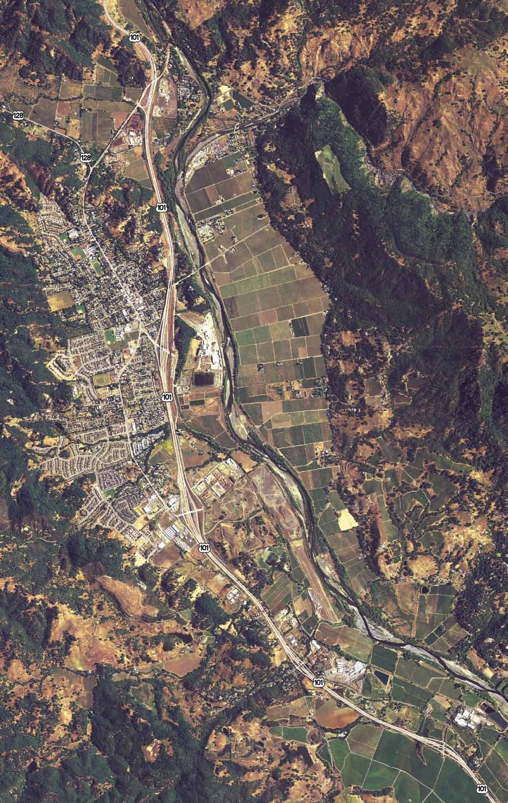
1 Did You Know... FACTS ABOUT CLOVERDALE History Incorporated in 1872, Cloverdale was once the Orange Belt of Sonoma County. Today, the History Center and Historical Society in downtown Cloverdale house a treasure of historical photos and exhibits. Tourism Great weather makes Cloverdale a perfect destination for wine tasting, biking, hiking and outdoor fun. Vacation rentals, B&B s, spas, wineries and restaurants cater to every tourist need. Location SMART train station will connect Mendocino, Sonoma and Marin counties. The Napa Valley and the Mendocino Coast are a day-trip on Hwy 128. Welcome To Cloverdale Cloverdale is located in the picturesque Alexander Valley wine region of Sonoma County, just off Northern California Highway 101 about 15 miles north of Healdsburg. With good proximity to urban centers (30 miles north of Santa Rosa and within easy driving distance to Marin County/San Francisco and north to Arcata/Eureka), Cloverdale is evolving as a smart growth city with small town charm. An Exceptional Place To Live The city proper covers 2.7 square miles with a population of approximately 11,032 (5 mile radius) and is surrounded by oak-studded rolling hills, outstanding recreational opportunities, wineries, vineyards and small farms. m Walkable and bikable neighborhoods dotted with family-oriented parks m Apartments and home prices ranging from the affordable to luxury m River Park on the Russian River and many more walking, hiking and biking trails m Moderate winters, warm summers m Balmy summer nights to enjoy downtown plaza events and Farmers Market Proactive Local Government Cloverdale s business-friendly city council/city manager form of government, a proactive Chamber of Commerce and an engaged community have made well-planned growth and economic development a priority. The City is committed to the revitalization of its historic downtown and has completed a downtown Plaza, Performing Arts Center, History Center, and SMART Train Depot. The approved 2009 General Plan Update provides and encourages development opportunities and land sites for employers, retailers and mixed use projects in downtown and within the city s urban growth boundary and sphere of influence, a total area of approximately 7.0 square miles. Ideal Setting For Business Cloverdale is the ideal location for companies looking to relocate where business innovation is encouraged and employee quality of life is exceptional. The city is proud home to Reuser Inc., manufacturer and bulk distributor of organic landscaping materials and Asti Winery, both recipients of many awards for sound environmental business practices. In Cloverdale, entrepreneurial and traditional businesses co-exist and complement each other. The City appreciates all businesses and works to retain businesses, encouraging expansion in Cloverdale. Cloverdale is a great place to live, work, play and do business. Contact us today for more information! Photography Courtesy Wayne Elliott, weoriginals.com Source: Claritas Inc. Courtesy Keegan & Coppin Company


2 Demographics Average age is 38 51% White Collar; 25% Blue Collar; 24% Service & Farm 48% High school grads/ some college; 25% college degree + Community The Cloverdale Reveille, locally owned and published, has been the hometown newspaper since Cloverdale s hundreds of local non-profits share information and resources for the benefit of the community. Entertainment The annual Cloverdale Citrus Fair began in1892 and is the first official fair in the state of California each year. Cloverdale s Old Time Fiddle Festival and Contest attracts music lovers everywhere. Arts The Cloverdale Performing Arts Center wows audiences with first class talent and plays. The Arts Alliance has year-round programs featuring local artisans in all media. CLOVERDALE COMMUNITY PROFILE Location, Location! m Close to urban centers m 15 minutes to Healdsburg Plaza m 10 minutes to Lake Sonoma fishing, biking, and boating m Surrounded by miles of vineyards and family-owned wineries POPULATION CHARACTERISTICS DESCRIPTION 5.0 MILE RADIUS 10.0 MILE RADIUS 20.0 MILE RADIUS Population 2009 est 11,032 13,521 86,383 Population 2014 proj 12,082 14,512 90,903 Avg Household Income 2009 est $69,863 $74,926 $77,354 Number of Households 2009 est 3,989 4,822 31,717 Number of Households 2014 proj 4,339 5,158 33,314 Population Hispanic or Latino 2009 est 34% 35% 28% Population Non Hispanic or Latino 2009 est 66% 65% 72% Population Male 2009 est 51% 52% 51% Population Female 2009 est 49% 48% 49% CLIMATE Cloverdale enjoys a seasonal climate with balmy summer evenings. Annual average rainfall is 44 inches. AVERAGE TEMPERATURES: MONTH HIGH LOW January March June July October % Age % Age 0-44 POPULATION BY AGE The population in Cloverdale s Trade Area is balanced between younger families at peak earning power, baby boomers, and retirees. Source: Claritas Inc. Courtesy Keegan & Coppin Company
3 Area The approved 2009 General Plan Update provides and encourages development opportunities and land sites for employers, retailers and mixed use projects in downtown and within the city s urban growth boundary and sphere of influence, a total area of approximately 7.0 square miles. Location With 3 freeway exits off Northern California Highway 101, Cloverdale is well-located for travel to Arcata/Eureka to the north and Sonoma/Marin/San Francisco Bay Area to the south. It also offers access to Napa, Mendocino, and Lake counties through east/west Hwy 128. The SMART Train depot is within walking distance of downtown. Parks, Recreation & Community Meeting Places m Furber Park, Vintage Meadows Park, River Park on Russian River, four ballparks m Veterans Center with public pool m Citrus Fairgrounds m Cloverdale Senior Center m Center for Performing Arts m Cloverdale History Center m Cloverdale Library Cultural, Entertainment & Points of Interest m Performing Arts Center m Citrus Fair m Cloverdale Historical Society and History Center m First Street Gallery m Cloverdale Arts Alliance m Grange and Young People s Performing Arts m Downtown movie theater m Hundreds of local wineries m Lake Sonoma 128 Downtown FOOTHILL BLVD CLOVERDALE BLVD Furber Plaza m Anderson Valley/Mendocino Coast HWY 128 EXIT CITRUS FAIR EXIT 101 SMART Train Depot S. CLOVERDALE BLVD. EXIT Reuser Industries Transportation m Rail: Freight, Passenger and Commuter Rail through SMART Train (est completion). m Truck: Many common carriers provide interstate and intrastate service. m Overnight Delivery: 1-2 day guaranteed delivery anywhere in the U.S. m Air Cloverdale Municipal Airport (1 mile south) Small, full-service municipal airport for light planes and general aviation. Charles M. Schulz / Sonoma County Airport (STS) 20 miles south serves Las Vegas, Los Angeles, Portland, and Seattle through Horizon Air with commuter connections to SFO. Drive-time to SFO, Oakland International and Sacramento International airports. Rental cars available at STS and in Cloverdale. m Bus: One city bus; Sonoma County Transit; Greyhound Bus Stop and Amtrak connection service. m Water: Ocean 30 miles; Barge service from Petaluma on Petaluma River to all inland ports on San Francisco Bay and the Delta. Medical Facilities m Alexander Valley Regional Medical Center- family practice, acute medical care, general dentistry, behavioral health and family counseling. m Cloverdale Health Care Center Skilled Nursing Facility m Ambulance Service m Local offices of dentists, chiropractors, acupuncturists and massage therapists m Healdsburg District Hospital, m Kaiser Foundation Hospital, Santa Rosa, m Santa Rosa Memorial Hospital, m Sutter Medical Center of Santa Rosa, Schools/Education m Cloverdale Unified School District serves 1570 students grades K-12 at two elementary schools, one comprehensive high school (Jefferson Elementary, Washington School and Cloverdale High School), and a continuation high school. m Approximately 36% of the students are Hispanic and 63% Caucasian. m Cooperative preschool program, Even Start and Head Start Programs. m There are a number of private schools in the area. For information on private schools in Sonoma County, m Santa Rosa Junior College, Empire College, USF North Campus and Sonoma State University provide a wide range of educational opportunities close by.


4 Business Locations and Development Opportunities Why Cloverdale? Cloverdale s Location Has Unique Regional Attributes Connectivity to Bay Area When You are Thinking of Re-locating Your Business. Think Cloverdale. With so many new and exciting development opportunities, Cloverdale is emerging as a smart place to do business. Located in the heart of the world-renowned Alexander Valley wine region of northern Sonoma County, Cloverdale is a perfect place for your employees to call home and to build and expand your business. There has never been a better time to consider Cloverdale. Strong competitive advantages 1. Located mid-point on Highway 101, just 80 miles north of the Golden Gate Bridge 2. A half-day drive to Arcata/Eureka on Hwy Drive to Silicon Valley for the day and back 4. Access to Lake, Mendocino, Napa and Sonoma counties 5. Convenient exits off Highway 101 to downtown and industrial, commercial, retail sites 6. SMART Train Depot just off freeway and within walking distance to downtown 7. Good interior road system that supports business traffic 8. Cloverdale Municipal Airport just one mile from downtown 9. Transit-Oriented destination with SMART Train Station 10. Close to urban centers Cloverdale s Business Community (Just some of the companies that have chosen to locate here) Reuser Inc. Redwood Credit Union Ray s Food Place Exchange Bank Kragen Auto Parts Mary s Pizza Starbucks Subway CVS Ace Hardware Antiques & Uniques Papa s Pizza Pick s Drive In Cloverdale s General Plan provides: Site planning flexibility Balanced and wide range of mixed land uses Historic Downtown Office and Retail Shopping Center Retail Mixed Use Transit-Oriented Uses Anchor-Store Destination Retail with Freeway Access Light Industrial with Freeway Access Commercial with Freeway Access First time Buyer to Retirement For Sale & Apartments Health Care and Continuing Senior Care Education & Cultural Entertainment and Community Tourism Government Site Development Opportunities Cloverdale is planning carefully so that it may retain its small town character and natural beauty. At the same time, the City s General Plan has designated several site development opportunities that will enable Cloverdale residents to enjoy the benefits of a vibrant and diverse economy. Listed below are some of the site development areas available. The City of Cloverdale appreciates all businesses and is committed to working with interested developers, employers and businesses. Downtown Transit-Oriented near SMART Depot Thyme Square Kelly Road Gateway Master Plan (Southwest Area) Asti Future Economic Zone (Southeast Area) Future Industrial Economic Zone (Southeast Area) Source: Claritas Inc. Courtesy Keegan & Coppin Company
5 Bring Your Business to Cloverdale! Companies that locate and do business in Cloverdale benefit from the internationally recognized Sonoma Brand- rustic wineries, organic foods, creative industries and innovative entrepreneurs. Sonoma County s schools, universities and companies are in the forefront of green technology. The county is fast evolving as Northern California s Innovation Corridor. For businesses and their employees, living in Cloverdale and Sonoma County couldn t be a better choice. HOUSING TRENDS Single-Family Multiple Family Mobile Total Housing Annual Percentage Year Units Units Homes Units Change , ,033 n/a , ,095 3% , ,158 3% , , % , , % , , % , , % , , % , , % , , % , , % , , % , , % , , % , , % , , % , , % , , % Housing Characteristics The number of housing units in Cloverdale has increased steadily since Today, Cloverdale has a balanced housing stock that includes first time buyer to luxury homes, active adult and senior living, apartment and townhome rentals and affordable housing. 10,000 CITY OF CLOVERDALE POPULATION GROWTH 8,000 6,000 4,000 Growth and Trends The city of Cloverdale is the fastest growing city in Sonoma County, with an annual average population increase of nearly 4 percent between 1998 and , (n/a) 1992 (+4.4%) 1994 (+2.0%) 1996 (+2.1%) 1998 (+2.2%) 2000 (+5.8%) 2002 (+3.5%) 2004 (+6.4%) 2006 (+2.6%) 2008 (+1.2%) EMPLOYMENT BY POPULATION (15 mile radius) Farming, Fishing and Forestry Construction, Extraction and Maintenance Management, Business and Financial Service Production, Transportation and Material Moving Professional and Related Occupations Sales and Office 0% 5% 10% 15% 20% 25% 2009 Economic & Demographic Profile Report
6


7 Cloverdale Trade Area Demographics 20 MILE /OR 25-MINUTE DRIVE-TIME RADIUS. Cloverdale
University of Michigan & Urban Land Institute Real Estate Forum. Mary Beth Graebert Michigan State University
 University of Michigan & Urban Land Institute Real Estate Forum Mary Beth Graebert Michigan State University November 20, 2013 Michigan State University Land Policy Institute Strong focus on research and
ALIVE. Proposal. Imagination. The. Toward a More Walkable and Less Car-Dependent Future. Learning. Vision. Action. Environment
 The ALIVE Proposal Toward a More Walkable and Less Car-Dependent Future A Twelve Step Approach to Open Up Our Imagination Prepared for The Community of Corvallis, Oregon and Oregon State University by
D O W N T O W N B A S E B A L L
 D O W N T O W N B A S E B A L L 1 Urban THREE GENERATIONS 2 Multipurpose 3 Revitalized Urban Bring out the best of San Jose 4 4 th GENERATION BUILDING A CITY PETCO Park San Diego, California THE BEST URBAN
COMMERCIAL PROPERTY FOR SALE OFFERED EXCLUSIVELY BY: KEVIN GORDON SACRAMENTO STREET, BERKELEY, CA
 COMMERCIAL PROPERTY FOR SALE 3007-3011 SACRAMENTO STREET, BERKELEY, CA OFFERED EXCLUSIVELY BY: KEVIN GORDON 510 898-0513 kevin@gordoncommercial.com CalBRE#01884390 Ideal for owner/user or investment in
Ellensburg CENTRALLY LOCATED
 Ellensburg CENTRALLY LOCATED Ellensburg was awarded two Opportunity Zone designations Opportunities Combined, the tracts total more than 6120 acres. Of that, 22 percent is designated for commercial or
The Impact of Placemaking Attributes on Home Prices in the Midwest United States
 The Impact of Placemaking Attributes on Home Prices in the Midwest United States 2 0 1 3 C O N S T R U C T E D E N V I R O N M E N T C O N F E R E N C E M A R Y B E T H G R A E B E R T M I C H I G A N
TAMPA BAY EXPRESS (TBX)
") TAMPA BAY EXPRESS (TBX) Hank Schneider, P.E. FDOT- District 7 Consultant Project Manager Florida Department of TRANSPORTATION TAMPA BAY EXPRESS AGENDA What is TBX? What does TBX do? Why is TBX Important?
TAMPA BAY EXPRESS (TBX) Hank Schneider, P.E. FDOT- District 7 Consultant Project Manager Florida Department of TRANSPORTATION TAMPA BAY EXPRESS AGENDA What is TBX? What does TBX do? Why is TBX Important?
Practicing what we preach in POMONA! Daryl Grigsby, Public Works Director, City of Pomona, California
 Practicing what we preach in POMONA! Daryl Grigsby, Public Works Director, City of Pomona, California Who lives in Pomona? 150,000 people: Young average age 26, 34% under 18 years old, and only 6.5% over
BUILDING THE CASE FOR TRAVEL OPTIONS IN WASHING TON COUNTY. Image: Steve Morgan. Image: Steve Morgan
 BUILDING THE CASE FOR TRAVEL OPTIONS IN WASHING TON COUNTY Image: Steve Morgan Image: Steve Morgan Image: TriMet Image: TriMet WHAT ARE TRAVEL OPTIONS PROGRAMS? Travel options programs encourage residents,
Customer Service and Operations Committee. Board Information Item III-A. March 12, 2015
 Customer Service and Operations Committee Board Information Item III-A March 12, 2015 Business Partnerships and Encouraging Off-Peak Ridership Page 3 of 30 Washington Metropolitan Area Transit Authority
Subject Property SOUTHWEST. Mohave Crossroads. Approximate alignment of proposed Road and new Bridge. y a. w P e u
 Approximate alignment of proposed Road and new Bridge y a w ark P ad e llh u B Subject Property Mohave Crossroads Commercial Center Bed Bath & Beyond 99 Ross Pet Smart Target Kohl s CVS Starbuck s Bullhead
For Lease Highly Visible Prime Corner at Signalized Intersection Pasadena Central Business District
 Highly Visible Prime Corner at Signalized Intersection Pasadena Central Business District 937 E Colorado Blvd. Pasadena, CA 91106 Primary Contacts: Monique Berry tel 310.806.6120 mberry@naicapital.com
INFRASTRUCTURE: Using the Grid to Create a more Self-Sustaining Downtown. Studio Spring 2013
 EMERGENT FUTURES The San Diego Section of the American Society of Civil Engineers (ASCE) released a new report, the 2012 San Diego County Infrastructure Report Card. Since the last San Diego Report Card
Table #6 VISION CHARACTERISTICS
 Table #6 VISION White Flint is a place to live, work, play, shop, and walk with sufficient density to encourage quality redevelopment. Vibrant streets and consistent streetscapes are important. CHARACTERISTICS
2.0 Ballpark District
 2.0 Ballpark District 2.1 Introduction The Ballpark District is located in the south central portion of the City of Lake Elsinore, just north of the City limit line in this area. The Ballpark District
tattersall park RBY EBSCO RETAIL PROPERTIES
 tattersall park EBSCO PROPERTIES RBY RETAIL the case for tattersall park... The 75-acre site OWNED by the developer (EBSCO) has a unique history. It is one of the most attractive multi use sites in the
NEWMARKET CENTRE Mobility Hub Profile
 Mobility Hub Profile Dundas Newmarket West-Bloor Centre Anchor Hub Gateway Hub N MOBILITY HUBS: Places of connectivity between regional and rapid transit services, where different modes of transportation
North Coast Corridor:
 North Coast Corridor: Connecting People, Transportation & Environment Legislative Hearing: 11.8.10 1 North Coast Corridor Region s Lifeline A Regional Strategy Mobility, Economy & Environment North Coast
DON MILLS-SHEPPARD Mobility Hub Profile
 DON MILLS-SHEPPARD Mobility Hub Profile Dundas Don Mills-Sheppard West-Bloor Anchor Hub Gateway Hub N MOBILITY HUBS: Places of connectivity between regional and rapid transit services, where different
Transportation Master Plan Advisory Task Force
 Transportation Master Plan Advisory Task Force Network Alternatives & Phasing Strategy February 2016 BACKGROUND Table of Contents BACKGROUND Purpose & Introduction 2 Linking the TMP to Key Council Approved
DON MILLS-EGLINTON Mobility Hub Profile
 Mobility Hub Profile Dundas Don Mills-Eglinton West-Bloor Anchor Hub Gateway Hub N MOBILITY HUBS: Places of connectivity between regional and rapid transit services, where different modes of transportation
THE TOURNAMENT Overview
 OBSERVER PROGRAMME THE TOURNAMENT Overview 2 A vibrant host city SAN FRANCISCO San Francisco is often called Everybody s Favourite City, a title earned by its scenic beauty, cultural attractions, diverse
Ann Arbor Downtown Street Plan
 1 Ann Arbor Downtown Street Plan Public Workshop #1 We know that. 2 Public right-of-way (streets, sidewalks, and alleys) make up 30% of the total District area of downtown. Streets need to provide mobility
Project Narrative. Albuquerque, NM. July 31, 2015
 Project Narrative Albuquerque, NM July 31, 2015 1 Project Identification As the first bus rapid transit (BRT) project in New Mexico, the Albuquerque Rapid Transit (ART) line will run through the heart
ECONOMIC DEVELOPMENT INTRODUCTION WHAT YOU WILL FIND IN THIS CHAPTER
 ECONOMIC DEVELOPMENT INTRODUCTION WHAT YOU WILL FIND IN THIS CHAPTER Information about the local economy including statistics on population, employment, businesses, and employment sectors. Policies and
Chapter 7. Transportation. Transportation Road Network Plan Transit Cyclists Pedestrians Multi-Use and Equestrian Trails
 Chapter 7 Transportation Transportation Road Network Plan Transit Cyclists Pedestrians Multi-Use and Equestrian Trails 7.1 TRANSPORTATION BACKGROUND The District of Maple Ridge faces a number of unique
FOR SALE. 202 Pacific Avenue, Bremerton, WA Historic Bremerton Trust and Savings Building
 FOR SALE 202 Pacific Avenue, Bremerton, WA 98337 Historic Bremerton Trust and Savings Building PROPERTY INFORMATION PRICE $1,750,000 BUILDING SIZE LOT SIZE 10,080 sq. ft. 4,792 sq. ft. (0.11 Acres) # OF
Walkable Retail: When Old Becomes New Again Part 1
 Walkable Retail: When Old Becomes New Again Part 1 By Erin Talkington, Vice President, and Jacob Ross, Associate You have probably read the following headline thousands of times, perhaps this year alone:
R etail. City of Hesperia HESPERIA. Main & I-15. City of Hesperia Inland Empire North Southern California
 5 Mile Population 110,520 Households 31,488 Avg HH Income $66,342 7 Mile Population 195,500 Households 57,120 Avg HH Income $62,365 10 Mile Population 287,046 Households 84,975 Avg HH Income $62,257 Main
3001 MISSION OAKS BOULEVARD - 309,500 SF (DIVISIBLE)
") BOULEVARD - 309,500 SF (DIVISIBLE) HIGH VISIBILITY DISTRIBUTION FACILITY IN HIGHLY FUNCTIONAL, INSTITUTIONALLY OWNED/MANAGED INDUSTRIAL BUILDING CAMARILLO, CA N 101 3001 MISSION OAKS BOULEVARD PROPERTY
BOULEVARD - 309,500 SF (DIVISIBLE) HIGH VISIBILITY DISTRIBUTION FACILITY IN HIGHLY FUNCTIONAL, INSTITUTIONALLY OWNED/MANAGED INDUSTRIAL BUILDING CAMARILLO, CA N 101 3001 MISSION OAKS BOULEVARD PROPERTY
Community & Transportation Preferences Survey
 Community & Transportation Preferences Survey Webinar: August 5, 2015 Hugh Morris, AICP, LEED Realtor.org Jennifer Dill, Ph.D. trec.pdx.edu 1 Introduction National Association of Realtors Over 1,000,000
Perryville TOD and Greenway Plan
 Perryville TOD and Greenway Plan Greenway Glossary Pathway: A bicycle and pedestrian path separated from motorized vehicular traffic by an open space, barrier or curb. Multi-use paths may be within the
CITY VIBE NATURAL BEAUTY
 SEATTLE, WASHINGTON CITY VIBE NATURAL BEAUTY Seattle is one of the fastest-growing, most highly educated major metropolitan markets. From high art to mountain peaks, there is something to interest everyone.
A Selection Approach for BRT Parking Lots Nicolls Road Corridor Parking Study
 A Selection Approach for BRT Parking Lots Nicolls Road Corridor Parking Study Chirantan Kansara, P.E. Engineering Construction Design Planning 2018 ITE Northeastern District Annual Meeting Lake George,
ALPHARETTA, GA FOR LEASE
 PROPERTY HIGHLIGHTS Approximately 18,283 SF two-story office building Up to 9,427 SF available for lease 6,377 RSF total contiguous space available (suite 200/210) Offered for lease at $15.50/SF full service
3175 MISSION OAKS BOULEVARD - 423,106 SF (DIVISIBLE)
") 3175 MISSION OAKS BOULEVARD - 423,106 SF (DIVISIBLE) HIGH VISIBILITY DISTRIBUTION FACILITY IN HIGHLY FUNCTIONAL, INSTITUTIONALLY OWNED/ MANAGED INDUSTRIAL BUILDING CAMARILLO, CA N 101 3175 MISSION OAKS
3175 MISSION OAKS BOULEVARD - 423,106 SF (DIVISIBLE) HIGH VISIBILITY DISTRIBUTION FACILITY IN HIGHLY FUNCTIONAL, INSTITUTIONALLY OWNED/ MANAGED INDUSTRIAL BUILDING CAMARILLO, CA N 101 3175 MISSION OAKS
San Bernardino County Non-Motorized Transportation Plan - Chapter 5
 City of Upland Population 76,106 City Overview The City of Upland was incorporated on May 15, 1906, after previously being named North Ontario. The City was originally established as an irrigation colony
Characteristics from these programs were used to compare to and evaluate existing conditions in Howard County.
 EXECUTIVE SUMMARY Bike share is a mobility option that allows users to access a fleet of public bicycles throughout a community. Bike share systems have successfully been implemented in communities throughout
Oregon 2011 Regional Visitor Report Mt. Hood Columbia River Gorge
 Oregon 2011 Regional Visitor Report Mt. Hood Columbia River Gorge Introduction Longwoods International began tracking American travelers in 1985, and has conducted large-scale syndicated visitor research
DeLand. DeBary. Sanford/SR 46. Lake Mary. Longwood Altamonte Springs. Maitland. Winter Park/Park Avenue
 P DeLand system map 2-hour off-peak service in each direction Up to 3-car train set 30-minute peak service in each direction from: 5:30 am 8:30 am 3:30 pm 6:30 pm P DeBary P PHASE 2 Sanford/SR 46 P Lake
EXECUTIVE SUMMARY: TRANSIT-ORIENTED DEVELOPMENT IN SMITHS FALLS, ONTARIO; A COMPARISON BETWEEN TWO SITES
 EECUTIVE SUMMARY: TRANSIT-ORIENTED DEVELOPMENT IN SMITHS FALLS, ONTARIO; A COMPARISON BETWEEN TWO SITES Topic and Purpose In 2007, the Mayor of Ottawa s Task Force on Transportation suggested adding a
Welcome. Background. Goals. Vision
 Welcome The formal Public Information Centre (PIC) for the Transportation Master Plan How We GO will be held in early 2017. At that time we will present the recommended transportation system for Niagara
Owner/Developer: Sun Garden Center 1, LLC SDS NexGen Partners, LP
 Owner/Developer: Sun Garden Center 1, LLC SDS NexGen Partners, LP 8 No. San Pedro St., Suite 300 San Jose, California 95110 Tel: 408.378.5900 RWarner@moinc.net Exclusively Offered by: 225 W Santa Clara
Flyaway Bus: GIS Analysis on Current and Potential Ridership, Revenue, and Prospective Stations
 ProfessorBarry Waite & Bonnie Shrewsbury Flyaway Bus: GIS Analysis on Current and Potential Ridership, Revenue, and Prospective Stations 1. Abstract The Flyaway Bus is a long distance non-stop shuttle
MEETING Agenda. Introductions. Project Overview. Key Study Components. Alternative Station Concepts. Preferred Station Concept. Next Steps.
 City GARLAND Council ROADVISION Briefing STUDY VISION STUDY Dallas, TX April 8, 2010 1 1 MEETING Agenda Introductions Project Overview Key Study Components Alternative Station Concepts Preferred Station
REDEVELOPMENT OPPORTUNITY! FOR SALE
 SALE PRICE: Contact Agent LOT SIZE: 0.31 Acres BUILDING SIZE: 2,830 SF YEAR BUILT: 1906 ZONING: CBD Central Business District CROSS STREETS: 2nd Street South PROPERTY OVERVIEW This offering is for the
The Technology of Speed Meets the Speed of Technology
 The Technology of Speed Meets the Speed of Technology Info.wy2m@gmail.com 408.916.7620 209.628.5654 Speed of Technology - Motor & Technology Center of Excellence From the Beauty and Sophistication of the
REDWOOD CREEK Mt.Zion 5748 Lucas Valley Rd Nicasio, CA 94946
 SAN FRANCISCO LIVING COUNTRYSIDE TRANQUILITY : 437 ACRES REDWOOD CREEK Mt.Zion 5748 Lucas Valley Rd Nicasio, CA 94946 ABOUT THE PROPERTY Nestled in the beautiful setting of Marin County and roughly 30
ATTACHMENT 4 - TDM Checklist. TDM Checklist Overview
 ATTACHMENT 4 - TDM Checklist TDM Checklist Overview The proposed checklist rates developments on the degree to which they are TDM and transit supportive. Points are assigned based on the level of transit
Vision Public Workshop: Findings
 Vision Public Workshop: Findings Long Range Transportation Plan & Bicycle Mobility Plan February 2018 Vision Workshop South Kingstown 1/23/18 Providence 1/24/18 Newport 1/31/18 Long Range Transportation
ECONOMIC DEVELOPMENT COMMITTEE. STRENGTHS and WEAKNESSES of STARTING and DOING BUSINESS IN SMITHERS
 and of STARTING and DOING BUSINESS IN SMITHERS Dave Walgren's Comments: 1. Community College. 1. Try to be all things to all people instead of focusing on what we do best. 2. Rail line and station. 2.
DALLAS MIDTOWN REDEVELOPMENT PLAN FOCUS NORTH TEXAS Peer Chacko, AICP, Assistant Director, City of Dallas
 DALLAS MIDTOWN REDEVELOPMENT PLAN FOCUS NORTH TEXAS 2014 Peer Chacko, AICP, Assistant Director, City of Dallas Dallas Midtown: Strategic growth area Future transit node 2 Peterson Road Study Area Galleria
Freddy s Frozen Custard & Steakburgers : Sale Leaseback : 5.65%
 Freddy s Frozen Custard & Steakburgers : Sale Leaseback : 5.65% PRICE:........................ $2,212,389 RENTABLE SF:...................... 3,053 SF ANNUAL RENT:................. $125,000 LOT SIZE:...........................869
ECONOMIC DEVELOPMENT ELEMENT
 ECONOMIC DEVELOPMENT ELEMENT Background The Economic Development Element considers labor force and labor force characteristics, employment by place of work and residence, and analysis of the community
Make a good day better.
 ONE PASEO Make a good day better. One Paseo is a deeper notion of mixed use. Yes, this is about the only place where a two-minute stroll takes you from your luxury apartment to your office, and from your
Riverside Rising Economic Outlook for the Region April 2015
 Analysis. Answers Riverside Rising Economic Outlook for the Region April 2015 Beacon Economics, LLC California fact versus fiction Looking back a few years (2009 / 2010) everyone was saying that CA would
2.0 Existing Conditions
 20 2.0 Existing Conditions 2.1 Land Use, Future Growth Patterns, Physical Barriers Geographic Overview Sutter County s land use pattern is characterized by extensive agricultural areas, significant natural
FROM: CITY MANAGER DEPARTMENT: PLANNING AND COMMUNITY ENVIRONMENT DATE: OCTOBER 4, 2004 CMR:432:04
 TO: HONORABLE CITY COUNCIL FROM: CITY MANAGER DEPARTMENT: PLANNING AND COMMUNITY ENVIRONMENT DATE: OCTOBER 4, 2004 CMR:432:04 SUBJECT: FINANCE COMMITTEE RECOMMENDATION TO ADOPT TRANSPORTATION STRATEGIC
welcome to quarry park
 welcome to quarry park Quarry Park is a mixed-use community with deep roots in Calgary s history. For more than 50 years the area was a gravel extraction site that occupied premium riverside real estate
WHY QUIKSILVER? Established in Many Grew Up with the brand. Global Recognition. Trusted Brand. Worn with Pride
 WHY QUIKSILVER? Established in 1969 Many Grew Up with the brand Global Recognition Trusted Brand Worn with Pride Over 800 Retail Outlets World-Wide Ultimate Marketing Reach BRAND VALUES: The core values
FULL PROFILE Census, 2018 Estimates with 2023 Projections Calculated using Weighted Block Centroid from Block Groups Realm Realty Lat/Lon: 3
 FULL PROFILE 2000-2010 Census, 2018 Estimates with 2023 Projections Calculated using Weighted Block Centroid from Block Groups Realm Realty Lat/Lon: 30.0027/-90.1613 RF1 Lakeside Shopping Center Metairie,
95 th Street Corridor Transportation Plan. Steering Committee Meeting
 95 th Street Corridor Transportation Plan Steering Committee Meeting August 11, 2014 PROJECT OBJECTIVES Develop a Transportation and Economic Plan for the 95 th Street Corridor Improve public transit efficiency
CITY VIBE NATURAL BEAUTY
 SEATTLE, WASHINGTON CITY VIBE NATURAL BEAUTY Seattle is one of the fastest-growing, most highly educated major metropolitan markets. From high art to mountain peaks, there is something to interest everyone.
ABERDEEN: CITY OF THE FUTURE
 ABERDEEN: CITY OF THE FUTURE A contribution towards discussions on a future transport strategy for Aberdeen and its Region Prepared by the Centre for Transport Research University of Aberdeen June 2010
New Seward and 36 th Avenue Intersection Conceptual Design
 University of Alaska Anchorage New Seward and 36 th Avenue Intersection Conceptual Design Prepared By: Zaid S. Hussein Dana Menendez Galen Jones Civil Engineering Department Prof. Osama Abaza CE A404 Highway
Downtown Pasco Development Authority 2013 Annual Report
 Downtown Pasco Development Authority Annual Report Michael Goins, Execuitve Director Downtown Pasco Development Authority January 13, director@downtowpasco.com www.downtownpasco.com 1 Executive Summary
Fitting Light Rail through Well-established Communities
 Fitting Light Rail through Well-established Communities San Francisco 2008 Michael D. Madden Chief, Project Development, Maryland Transit Administration Project Setting Located inside the Capital Beltway
SOLANA BEACH BICYCLE TRANSPORTATION PLAN SECOND ADDENDUM
 SOLANA BEACH BICYCLE TRANSPORTATION PLAN SECOND ADDENDUM Prepared by the City of Solana Beach January 2005 Introduction In June of 1993, the Solana Beach City Council adopted a Bikeway Master Plan as directed
TOWN OF WILLIAMSTON, SC BICYCLE AND PEDESTRIAN MASTER PLAN TOWN OF WILLIAMSTON, SC BICYCLE AND PEDESTRIAN MASTER PLAN
 TOWN OF WILLIAMSTON, SC BICYCLE AND PEDESTRIAN MASTER PLAN Americans Want Choices 55% of Americans would rather drive less & walk more. Transit use is growing faster than population or highway travel.
Chapter 2. Bellingham Bicycle Master Plan Chapter 2: Policies and Actions
 Chapter 2 Bellingham Bicycle Master Plan Chapter 2: Policies and Actions Chapter 2: Policies and Actions The Bicycle Master Plan provides a road map for making bicycling in Bellingham a viable transportation
Oceanside Services
 Oceanside Services www.visitoceanside.com 1-800-350-7873 Getting Around Oceanside There are three major north-south roads and four major east-west roads. North-South Roads South Coast Hwy. Interstate 5
nipigon.net Township of Nipigon 2018 Community Profile
 nipigon.net Township of Nipigon V 1.0 February 2018 2018 Nipigon nipigon.net nipigon.net Township of Nipigon nipigon.net Township of Nipigon nipigon.net Township of Nipigon nipigon.net Township of Nipigon
THE I-79 CORRIDOR. I-79 provides motorists with connections to the following major highways: I-80, PA 358, PA 965 and PA 208.
 The I-79 Corridor Pittsburgh to Erie Regional Thruway I-79 was constructed through Mercer County in the early 1960s. The portion north of PA 965 opened in 1961 and the segment south of PA 965 the following
Cities Connect. Cities Connect! How Urbanity Supports Social Inclusion
 Cities Connect! How Urbanity Supports Social Inclusion Todd Litman Victoria Transport Policy Institute Metropolis Toronto, Canada - 14 June 2006 Cities Connect People with people. People with jobs. People
Big 5 Sporting Goods. Northern California. Just opened major commercial street public company-rent increases
 Big 5 Sporting Goods Northern California Just opened major commercial street public company-rent increases For more info on this opportunity please contact: Rick Sanner rsanner@capitalpacific.com (415)
Urban planners have invested a lot of energy in the idea of transit-oriented
 DOES TRANSIT-ORIENTED DEVELOPMENT NEED THE TRANSIT? D A N I E L G. C H AT M A N Urban planners have invested a lot of energy in the idea of transit-oriented developments (TODs). Developing dense housing
Community Improvement Plans: Creating walkable and liveable communities that support local business
 Community Improvement Plans: Creating walkable and liveable communities that support local business Kate Hall Program Manager ~ WALK Friendly Ontario Canada Walks, Green Communities Canada khall@greencommunitiescanada.org
National Community and Transportation Preferences Survey. September 2017
 National Community and Transportation Preferences Survey September Executive Summary - Overview The Community and Transportation Preferences Survey echoes many of the major findings from the previous surveys.
Cottage Grove Road Activity Centers Plan
 Cottage Grove Road Activity Centers Plan Cottage Grove Road January 31, 2107 Kick Off Meeting Input Cottage Grove Road Corridor Visioning Exercise What would you like to see in 20 years? 10 Years? A vision
NATIONAL ACTION STRATEGY A VOICE FOR WALKING
 NATIONAL ACTION STRATEGY A VOICE FOR WALKING Canadians are coming together to create a unified voice for walking and to pick up the pace of action for walkable communities. Our goal: to restore everyday
Circulation in Elk Grove includes: Motor vehicles, including cars and trucks
 Circulation, as it is used in this General Plan, refers to the many ways people and goods move from place to place in Elk Grove and the region. Circulation in Elk Grove includes: Motor vehicles, including
Hennepin County Bicycle and Pedestrian Planning
 Hennepin County Bicycle and Pedestrian Planning 1 Value of bicycle and sidewalk systems Safety Livability Mobility Health Personal Finances Economic Sustainability Clean Air Recreation Parking and congestion
About the Active Transportation Alliance
 About the Active Transportation Alliance Chicagoland s voice for better biking, walking and transit Founded 1985 7,000 members, ~33 full time staff Serve Chicago metro region 1 More Cars, More Driving
Cherry Creek Transportation and Land Use Forum September 25, 2013 Meeting Summary
 Cherry Creek Transportation and Land Use Forum September 25, 2013 Meeting Summary I. LEAD-IN TO SMALL GROUP DISCUSSION, POLLING AND STEERING COMMITTEE/TECHNICAL TASK FORCE DISCUSSION The meeting began
NORTH YORK CENTRE Mobility Hub Profile
 Mobility Hub Profile Dundas North York West-Bloor Centre Anchor Hub Gateway Hub N MOBILITY HUBS: Places of connectivity between regional and rapid transit services, where different modes of transportation
STRATEGIC PLANNING FOR DEVELOPMENT OF THE OREGON SHORT LINE TERMINUS HISTORIC DISTRICT
 STRATEGIC PLANNING FOR DEVELOPMENT OF THE OREGON SHORT LINE TERMINUS HISTORIC DISTRICT & AN EXECUTIVE SUMMARY OF THE HEART OF WEST YELLOWSTONE CONCEPTUAL PLANNING REPORT November 2004 PREPARED BY The Portico
Ranking Walkable Urbanism in America s Largest Metros
 Ranking Walkable Urbanism in America s Largest Metros The Largest 30 Metros in the United States SHARE OF U.S. POPULATION SHARE OF U.S. GDP 54% 46% 42% 58% LARGEST 30 METROS REST OF U.S. The Old Dichotomy
good walking is good business making massachusetts more walkable
 good walking is good business making massachusetts more walkable Nothing draws a crowd like a crowd. P.T. Barnum 15 minutes with WalkBoston who we are / what we do why walkability makes economic sense
WELCOME EXERCISE. Share your thoughts on the study area by: Placing a GREEN DOT on areas you like or where something good is happening and;
 WELCOME EXERCISE Share your thoughts on the study area by: Placing a GREEN DOT on areas you like or where something good is happening and; Placing a RED DOT on areas you don t like or where area needs
June 2015 REGIONAL TRANSPORTATION SNAPSHOT
 June 2015 REGIONAL TRANSPORTATION SNAPSHOT THE REGION Who are we? The Greater Toronto and Hamilton Area (GTHA), consisting of Durham Region, Halton Region, the City of Hamilton, Peel Region, the City of
METRO RTA TRANSIT MASTER PLAN. May 25-26, 2011
 METRO RTA TRANSIT MASTER PLAN May 25-26, 2011 WHAT IS THE TRANSIT MASTER PLAN? A twenty-year plan for METRO RTA What will METRO look like in 2031? 1 TRANSIT TECHNOLOGIES 2 TRANSIT TECHNOLOGIES Transit
Perryville Transit Oriented Development & Greenway Plan
 A Partnership of the Town of Perryville and WILMAPCO Perryville Transit Oriented Development & Greenway Plan Why plan for TOD and Greenways? Identify strategies to enhance community character in Perryville
Evan Johnson, Tindale Oliver & Associates. Alan Danaher, P.E., PTOE, AICP, PTP
 To: Copies: From: Evan Johnson, Tindale Oliver & Associates Matt Muller, RTS Jesus Gomez, RTS Alan Danaher, P.E., PTOE, AICP, PTP Date: January 14, 2014 Subject: Ridership Projections Gainesville Streetcar
Transportation 2040 Update: Eudora Public Input As of June 1, 2017
 Transportation 2040 Update: Eudora Public Input As of June 1, 2017 Overview... 1 Survey Responses... 2 Overview The Lawrence Douglas County Metropolitan Planning Organization (MPO) is updating our long
Changing Commuting Patterns and Impacts on Planning & Infrastructure. William E. Frawley, AICP Texas A&M Transportation Institute October 3, 2013
 Changing Commuting Patterns and Impacts on Planning & Infrastructure William E. Frawley, AICP Texas A&M Transportation Institute October 3, 2013 Change is Constant... Various studies and data sources 1960
{ make your connection }
 { make your connection } connect with a new way to work Located at 2955, 2975 and 2995 Red Hill Avenue in Costa Mesa, near The LAB and The Camp in the SoBeCa district, The Landing on Red Hill is extremely
5/7/2013 VIA . RE: University Village Safeway Expansion (P13-019)
") 5/7/2013 VIA EMAIL David Hung, Associate Planner Community Development Department, Current Planning Division City of Sacramento 300 Richards Boulevard, 3 rd Floor Sacramento, CA 95811 RE: University Village
5/7/2013 VIA EMAIL David Hung, Associate Planner Community Development Department, Current Planning Division City of Sacramento 300 Richards Boulevard, 3 rd Floor Sacramento, CA 95811 RE: University Village
1999 On-Board Sacramento Regional Transit District Survey
 SACOG-00-009 1999 On-Board Sacramento Regional Transit District Survey June 2000 Sacramento Area Council of Governments 1999 On-Board Sacramento Regional Transit District Survey June 2000 Table of Contents
Economic Benefits of Bicycle and Pedestrian Facilities
 Economic Benefits of Bicycle and Pedestrian Facilities Ursula Lemanski National Park Service Rivers & Trails Program Rappahannock Rapidan Regional Commission Living Towns Workshop Village of Marshall July
36 APPROVED SINGLE FAMILY RESIDENTIAL LOTS
 SALE PRICE: $850,000 PRICE PER ACRE: $97,589 PRICE PER LOT: $23,611 LOT SIZE: 8.71 Acres APN #: 231-700-13 ZONING: R-1 Residential MARKET: City Of Lemoore SUB MARKET: Lemoore Golf Course Submarket PROPERTY