WELCOME EXERCISE. Share your thoughts on the study area by: Placing a GREEN DOT on areas you like or where something good is happening and;
|
|
|
- Barbra Payne
- 5 years ago
- Views:
Transcription
1 WELCOME EXERCISE Share your thoughts on the study area by: Placing a GREEN DOT on areas you like or where something good is happening and; Placing a RED DOT on areas you don t like or where area needs improvement.


2 Buford Livable Centers Initiative 10-Year Update January 27, 2016 Kickoff Meeting January 27, 2016

3 PROJECT TEAM
 program administered by the Atlanta Regional Commission (ARC), which: Courtesy of Atlanta Regional")
4 WHAT IS THE LIVABLE CENTERS INITIATIVE? Forward Buford is the 10-Year Update to the City of Buford LCI (Livable Centers Initiative) program administered by the Atlanta Regional Commission (ARC), which: Courtesy of Atlanta Regional Commission Links land use, transportation + market analysis in town centers, activity centers, and corridors. Provides planning grants Provides transportation infrastructure funding

5 LIVING CENTERS INITIATIVE GOALS 1 2 Utilize an inclusive planning process Access to a full range of transportation modes create new plans for quality growth and help develop innovative policies that support more vibrant, connected communities. (ARC) 3 4 Promote a diverse mix of land uses and housing options Focus future growth where it makes sense

6 STUDY AREA 2,752.3 ACRES AND INCLUDES: Downtown Core South Hill St Historic District Buford Hwy Corridor Main St Corridor Residential communities north of Buford Hwy Commercial sites south of Buford Hwy Connection to I985 Major retail locations - i.e. Home Depot and Walmart Light industrial in westernmost section of study area Central Buford schools in easternmost section of study area

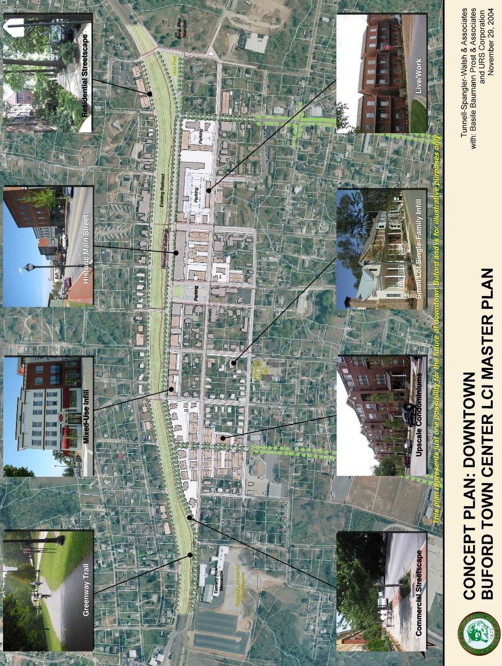
7 ORIGINAL LCI PLAN

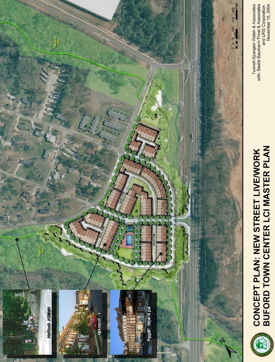
8 ORIGINAL LCI CONCEPT PLAN

9 ORIGINAL LCI COMMUNITY GOALS
10 =8 9 Reinforce the role of the Main Street as Buford s center Provide an interconnected street system supporting a range of route options, transportation modes and reduced congestion. Ensure that walking is safe, convenient and enjoyable. Create a dignified public realm that encourages human interaction and promotes civic identity. Preserve a sense-of-place by protecting downtown s historic buildings and ensuring that new buildings provide quality architecture appropriate to Buford. Provide a mix of land uses within close proximity, while protecting existing residential areas. Provide well-maintained roads that facilitates the smooth flow of traffic on the community s terms. Increase the use and convenience of GCT buses and the viability of bicycling in the study area. Create a cohesive, pedestrian-oriented retail environment along Main Street that functions as a unified whole, rather than a collection of parts.
11
12 =8 9 Reinforce the role of the Main Street as Buford s center Provide an interconnected street system supporting a range of route options, transportation modes and reduced congestion. Ensure that walking is safe, convenient and enjoyable. Create a dignified public realm that encourages human interaction and promotes civic identity. Preserve a sense-of-place by protecting downtown s historic buildings and ensuring that new buildings provide quality architecture appropriate to Buford. Provide a mix of land uses within close proximity, while protecting existing residential areas. Provide well-maintained roads that facilitates the smooth flow of traffic on the community s terms. Increase the use and convenience of GCT buses and the viability of bicycling in the study area. Create a cohesive, pedestrian-oriented retail environment along Main Street that functions as a unified whole, rather than a collection of parts.
13
14 =8 9 Reinforce the role of the Main Street as Buford s center. Provide an interconnected street system supporting a range of route options, transportation modes and reduced congestion. Ensure that walking is safe, convenient and enjoyable. Create a dignified public realm that encourages human interaction and promotes civic identity. Preserve a sense-of-place by protecting historic buildings and ensuring that new buildings provide quality architecture appropriate to Buford. Provide a mix of land uses within close proximity, while protecting existing residential areas. Provide well-maintained roads that facilitates the smooth flow of traffic on the community s terms. Increase the use and convenience of GCT buses and the viability of bicycling in the study area. Create a cohesive, pedestrian-oriented retail environment along Main Street that functions as a unified whole, rather than a collection of parts.
15


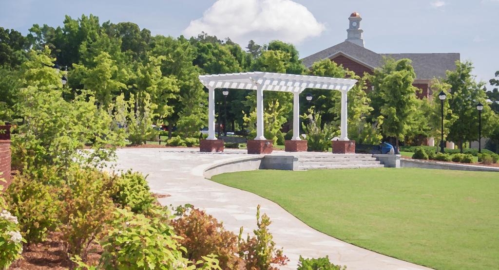
16 RECENT ACCOMPLISHMENTS - PUBLIC Buford City Hall Buford Town Park and Community Center Buford High School Underway City Conservation Buford Highway School Central Office Main Street Park

17 RECENT ACCOMPLISHMENTS - PUBLIC South Hill Street South Lee Street Forest Street/Sawnee Avenue Connector Main Street Directional Signage

18 RECENT ACCOMPLISHMENTS - PRIVATE Buford Village Mason Building Oak Brook Plaza Brickton North Hamilton Point Buford Youth Sports Complex Buford Care Dale Brown Building Espy Street Subdivision - Planned

19 MOVING FORWARD
20 THE PLANNING PROCESS WE ARE HERE! RESEARCH & ANALYSIS VISIONING DRAFT PLAN FINAL PLAN DECEMBER/JANUARY Site visit Existing conditions assessment Previous plans assessment Core team meeting 1 Kickoff meeting Stakeholder interviews

21 LAND USE + DESIGN Housing? Parks and Open Space? Development Opportunities? Business and Commercial Centers? Public Facilities? What does it look like?

22 MARKET STUDY Demographics Retail & Commercial Employment Housing Business Development
23 MARKET STUDY: Demographics Buford Population Change % population growth % projected by 2020 $49,354 Median HH Income Region 90% 80% 70% 60% 50% 40% 30% 20% 10% 0% 2% 23% 70% Robust growth since 2000 Rates slowed during recession, increasing Highest growth/income highest income = Suwanee, Forsyth Co, Sugar Hill Study Area Marginal growth and projection, but Trade area outpacing much of region in growth, incomes $100,000 $90,000 $80,000 $70,000 $60,000 $50,000 $40,000 $30,000 $20,000 $10,000 $ Median Household Income $37,730 $49,354 $66,923
 Still localized demand in key categories Grocery, Specialty foods Apparel women s, accessory")

24 MARKET STUDY: Retail Greater Buford area is retail magnet Study Area = $234 million inflow Buford = $584 m 10 min = $1.27 B (Mall of Georgia) Still localized demand in key categories Grocery, Specialty foods Apparel women s, accessory Specialty retail jewelry, gifts, sporting goods, used mdse Restaurants full service Potential for study area, downtown $100,000 $90,000 $80,000 $70,000 $60,000 $50,000 $40,000 $30,000 $20,000 $10,000 $ Median Household Income $37,730 $49,354 $66,923
25 MARKET STUDY: Residential Buford Market $181,785 median value avg Listing = $225k Gwinnett avg Sales 12/15 = $236k 90% of market Single Family detached Regional Market Strongly affected by housing bubble. Starts and prices declined, days on market increased Improved, stable, slow $300,000 $250,000 $200,000 $150,000 $100,000 $50,000 $- SF Residential Building Permits - Gwinnett County Buford Market Activity Avg List Avg Sold


26 MARKET STUDY: Employment Buford Predominantly Retail & Accommodation/Food Exit % commute outside of Buford Key clusters exist at: Hamilton Mill Business Center Bristol Industrial Way Lee, Highway 23 Gwinnett County Professional, Technical 3% Health Care 4% Other Serv. 4% Educational Services 5% Admin/ Support 8% Wholesale Trade 9% Buford 2013 Employment Warehousing/ Trans 3% Construction 9% Retail Trade 22% Accommodation / Food 15% Manufacturing 12% 4.6% Unemployment (GA 5.5) 60% commute $49,036 avg. wage Atlanta regional WIA

27 TRANSPORTATION Roadways? Sidewalks? Bicycle facilities? Connectivity? Shuttles? What are the priorities?

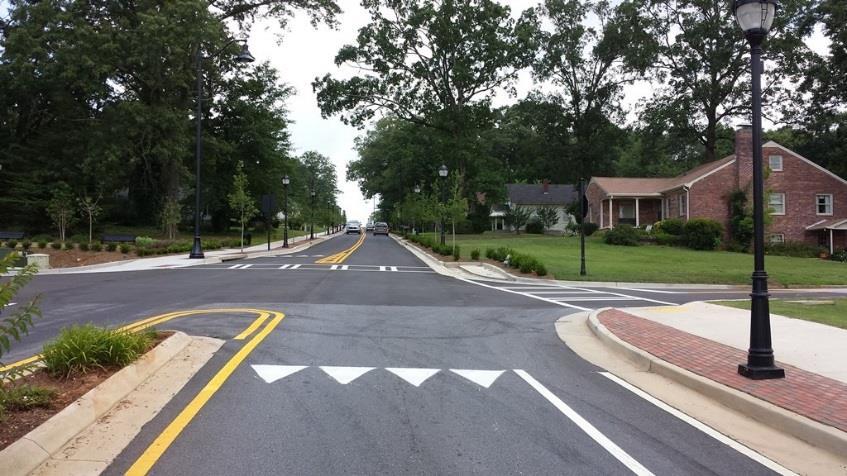
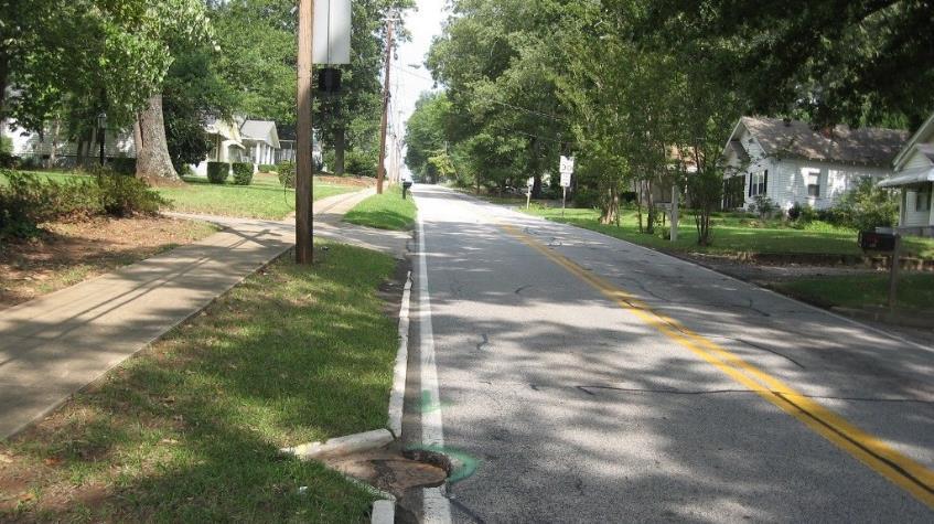
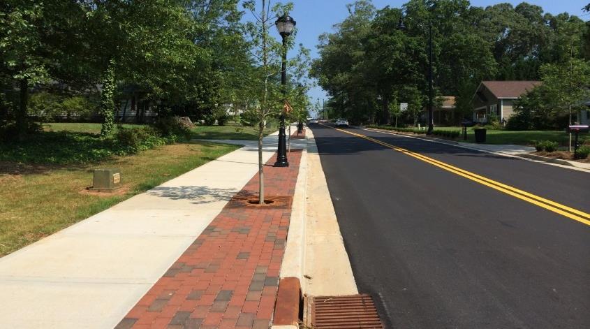
28 AFTER BEFORE TRANSPORTATION SOUTH HILL STREET

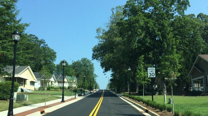
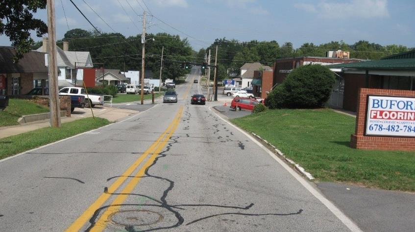
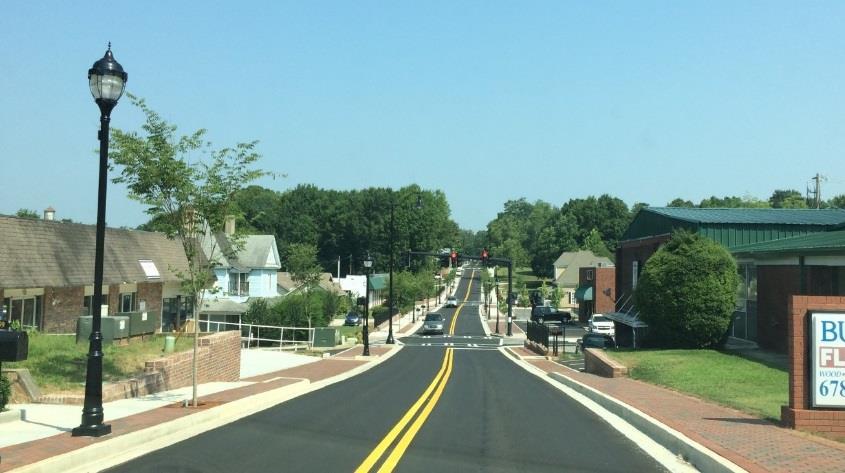
29 AFTER BEFORE TRANSPORTATION SOUTH HILL STREET

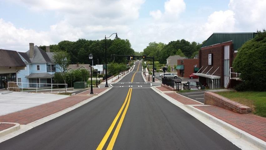
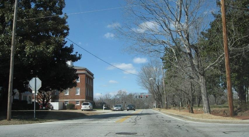
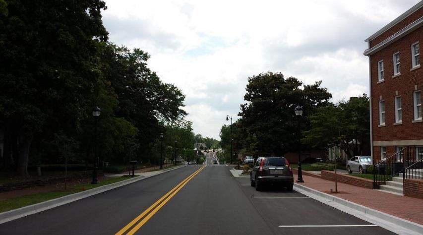
30 AFTER BEFORE TRANSPORTATION SOUTH HILL STREET

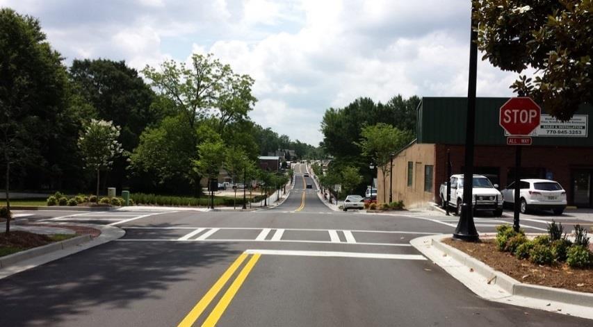
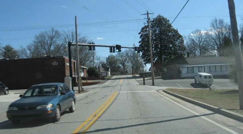
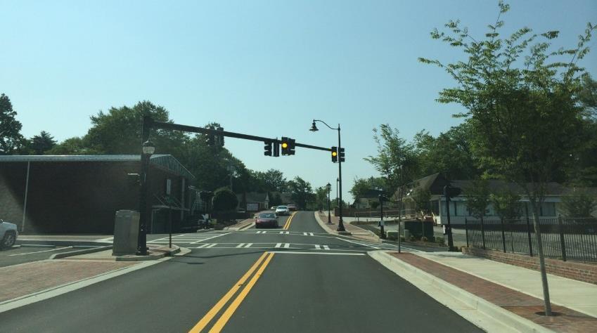
31 AFTER BEFORE TRANSPORTATION SOUTH HILL STREET

32 PROJECT WEBSITE
33 Q+A

34 1. IMAGE PREFERENCE SURVEY Housing Parks + open space Development opportunities Business + commercial centers Public facilities 2. COMMENT STATIONS Land use and design Transportation Market Study 3. AFFIRM PREVIOUS GOALS EXERCISES NEXT STEPS: Community Workshop Date To Be Determined
Ann Arbor Downtown Street Plan
 1 Ann Arbor Downtown Street Plan Public Workshop #1 We know that. 2 Public right-of-way (streets, sidewalks, and alleys) make up 30% of the total District area of downtown. Streets need to provide mobility
4. Action Plan & Projects
 4. Action Plan & Projects 45 46 ACTION PLAN AND PROJECTS The Action Plan organizes the list of transportation projects described in the Mobility Framework Plan section into short-term (0-5 years) and long-term
I-20 East Transit Initiative. Stakeholder Advisory Committee Meeting September 9, :00-6:00 PM
 I-20 East Transit Initiative Stakeholder Advisory Committee Meeting September 9, 2010 4:00-6:00 PM Meeting Agenda Introductions Project Background Study Overview Role of the SAC Initial Study Findings
Berkeley Strategic Transportation Plan A-76
 Berkeley Strategic Transportation Plan A-76 Appendices 1. A Team Effort 2. Where We ve Been A-11 Berkeley Strategic Transportation Plan Alameda County Transportation Plan Alameda County will be served
Natick Comprehensive Master Plan PHASE I COMMUNITY MEETING. November 29, 2016
 Natick 2030+ Comprehensive Master Plan PHASE I COMMUNITY MEETING November 29, 2016 Tonight s Agenda Project Introduction Breakout group discussion of vision & goals: Land Use, Housing & Economic Development
Table #6 VISION CHARACTERISTICS
 Table #6 VISION White Flint is a place to live, work, play, shop, and walk with sufficient density to encourage quality redevelopment. Vibrant streets and consistent streetscapes are important. CHARACTERISTICS
Make Lincoln Highway an economically vibrant corridor that is safe, efficient, and beautiful for local residents and visitors.
 Lincoln Highway Streetscape Plan Stakeholder Workshop #2 Handout Contents Introduction and Project Vision Planning Principles Specific Recommendations including a Proposed Typical Roadway Section Renderings
DON MILLS-EGLINTON Mobility Hub Profile
 Mobility Hub Profile Dundas Don Mills-Eglinton West-Bloor Anchor Hub Gateway Hub N MOBILITY HUBS: Places of connectivity between regional and rapid transit services, where different modes of transportation
NEWMARKET CENTRE Mobility Hub Profile
 Mobility Hub Profile Dundas Newmarket West-Bloor Centre Anchor Hub Gateway Hub N MOBILITY HUBS: Places of connectivity between regional and rapid transit services, where different modes of transportation
Exhibit 1 PLANNING COMMISSION AGENDA ITEM
 Exhibit 1 PLANNING COMMISSION AGENDA ITEM Project Name: Grand Junction Circulation Plan Grand Junction Complete Streets Policy Applicant: City of Grand Junction Representative: David Thornton Address:
San Mateo County Comprehensive Bicycle and Pedestrian Plan Open House
 San Mateo County Comprehensive Bicycle and Pedestrian Plan Open House October 28, 2010 Presented to San Mateo County residents and interested parties by Lauren Ledbetter, Alta Planning + Design Matt Haynes,
Executive Summary Route 30 Corridor Master Plan
 Route Corridor Master Plan Project Overview The Route Corridor Master Plan is a coordinated multimodal transportation and land use plan for the entire stretch of Route through East Whiteland Township,
Speed Limits Study and Proposal. Public Input Session: 8/14/13
 Speed Limits Study and Proposal Public Input Session: 8/14/13 Why is Decatur a unique place for this project? First Community Transportation Plan in the nation with a Health Impact Assessment. Strong sense
tattersall park RBY EBSCO RETAIL PROPERTIES
 tattersall park EBSCO PROPERTIES RBY RETAIL the case for tattersall park... The 75-acre site OWNED by the developer (EBSCO) has a unique history. It is one of the most attractive multi use sites in the
Tonight is for you. Learn everything you can. Share all your ideas.
 Strathcona Neighbourhood Renewal Draft Concept Design Tonight is for you. Learn everything you can. Share all your ideas. What is Neighbourhood Renewal? Creating a design with you for your neighbourhood.
CONNECTING PEOPLE TO PLACES
 CONNECTING PEOPLE TO PLACES 82 EAST BENCH MASTER PLAN 07 Introduction The East Bench transportation system is a collection of slow moving, treelined residential streets and major arteries that are the
95 th Street Corridor Transportation Plan. Steering Committee Meeting
 95 th Street Corridor Transportation Plan Steering Committee Meeting August 11, 2014 PROJECT OBJECTIVES Develop a Transportation and Economic Plan for the 95 th Street Corridor Improve public transit efficiency
DON MILLS-SHEPPARD Mobility Hub Profile
 DON MILLS-SHEPPARD Mobility Hub Profile Dundas Don Mills-Sheppard West-Bloor Anchor Hub Gateway Hub N MOBILITY HUBS: Places of connectivity between regional and rapid transit services, where different
Vision: Traditional hamlet with an attractive business/pedestrian friendly main street connected to adjacent walkable neighborhoods
 N D. Focus Area II Vision: Traditional hamlet with an attractive business/pedestrian friendly main street connected to adjacent walkable neighborhoods Transit Road Focus Area II is located in the Hamlet
2015 Florida Main Street Annual Conference. Complete Streets Equal Stronger Main Streets
 WHAT ARE COMPLETE STREETS? CASE STUDIES COMPLETING YOUR MAIN STREET 2015 Florida Main Street Annual Conference St. Petersburg, Florida August 19, 2015 WHAT ARE COMPLETE STREETS? CASE STUDIES COMPLETING
City of Hamilton s Transportation Master Plan (TMP) Public Consultation 3 December 2015
 Public Consultation 3 December 2015") City of Hamilton s Transportation Master Plan (TMP) Public Consultation 3 December 2015 McPhail Transportation Planning Services Ltd. AGENDA 6:00 7:00 pm Viewing Boards / Q & A with the Team 7:00 7:50
City of Hamilton s Transportation Master Plan (TMP) Public Consultation 3 December 2015 McPhail Transportation Planning Services Ltd. AGENDA 6:00 7:00 pm Viewing Boards / Q & A with the Team 7:00 7:50
The Shops at Lake Havasu I Lake Havasu, AZ
 The Shops at Lake Havasu I Lake Havasu, AZ cyoung@capital-rev.com 1 Investment Summary Location: 5601 N. Highway 95 South Lake Havasu, AZ Price: $5,125,269.60 Lot Size 26.58 Acres Price Per Sq. Ft. Pads
A CHANGING CITY. of Edmonton, it is essential that it reflects the long-term vision of the City.
 A CHANGING CITY By the year 2040, Edmonton will be home to more than 1 million people. To accommodate growth and support a healthy and compact city, we need a new approach to development/redevelopment
City Council Briefing March 18, Draft Working Ideas for Confirmation of Direction
 City Council Briefing March 18, 2014 Draft Working Ideas for Confirmation of Direction Draft Working Ideas for Confirmation of Direction Overall Study Area Regional Population Growth Plan for Today and
New Park Avenue Corridor West Hartford
 New Park Avenue Corridor West Hartford Current TOD Investment in the Corridor Mixed-use building currently under development by the Trout Brook Realty Advisors: a separate non-profit corporation, established
DUNDAS WEST-BLOOR Mobility Hub Profile
 Mobility Hub Profile Dundas West-Bloor Anchor Hub Gateway Hub N MOBILITY HUBS: Places of connectivity between regional and rapid transit services, where different modes of transportation come together
Rail Station Fact Sheet Downtown Carrollton Station
 Rail Station Fact Sheet Downtown Carrollton Station Station Overview Downtown Carrollton Station is located at East Belt Line Road and Broadway Street near the historic Downtown Carrollton Square. The
Markham Sports, Entertainment and Cultural Centre Transportation Overview
 Markham Sports, Entertainment and Cultural Centre Transportation Overview ARENA LOCATION 2 3 TRANSPORTATION VISION IN MARKHAM On April 12, 2011, Markham Council adopted a long-term Transportation Vision
36 APPROVED SINGLE FAMILY RESIDENTIAL LOTS
 SALE PRICE: $850,000 PRICE PER ACRE: $97,589 PRICE PER LOT: $23,611 LOT SIZE: 8.71 Acres APN #: 231-700-13 ZONING: R-1 Residential MARKET: City Of Lemoore SUB MARKET: Lemoore Golf Course Submarket PROPERTY
S T A T I O N A R E A P L A N
 The Circulation and Access Plan describes vehicle, pedestrian, and transit improvements recommended within the Concept Plan. In order to create and sustain a vibrant business district that provides pedestrian-friendly
Austell Road Access Management Plan Public Meeting February 17, 2009
 Austell Road Access Management Plan Public Meeting February 17, 2009 Laraine Vance: Dan Cohen: Cobb DOT Project Manager Pond & Company Planning Director 1 Access Management What is Access Management? The
A Guide to Great Streets: The Basics. September 25, 2009
 A Guide to Great Streets: The Basics September 25, 2009 Streets are more than connectors, they are the city 2 Streets are the glue that hold a city together 3 Streets are the means in which a city is perceived
Meeting Summary Public Information Meeting #1 Warren County Pathway Corridor Project September 27, 2018
 Meeting Summary Public Information Meeting #1 Warren County Pathway Corridor Project September 27, 2018 The first public information meeting for the Warren County Pathway Corridor Project was held on Thursday,
Chapter 7. Transportation. Transportation Road Network Plan Transit Cyclists Pedestrians Multi-Use and Equestrian Trails
 Chapter 7 Transportation Transportation Road Network Plan Transit Cyclists Pedestrians Multi-Use and Equestrian Trails 7.1 TRANSPORTATION BACKGROUND The District of Maple Ridge faces a number of unique
Characteristics from these programs were used to compare to and evaluate existing conditions in Howard County.
 EXECUTIVE SUMMARY Bike share is a mobility option that allows users to access a fleet of public bicycles throughout a community. Bike share systems have successfully been implemented in communities throughout
Mainstreet Master Plan Land Use
 Mainstreet Master Plan 04 Land Use Top Recommendations Active Uses: Promote active ground-floor uses such as retail, restaurants, galleries and personal services with interactive storefronts for Mainstreet
Approaches. Livable Neighborhood Design. Examples. Traditional neighborhood development. CE 594 University of Wisconsin- Milwaukee
 Approaches Livable Neighborhood Design CE 594 University of Wisconsin- Milwaukee Traditional neighborhood design (TND), new urbanism, transit friendly design, transit oriented development and walkable
summary of issues and opportunities
 1 summary of issues and opportunities EXECUTIVE SUMMARY CHAPTER 2: HISTORY - 3: LAND USE This first chapter is an overview of lessons learned from analysis of the existing conditions on El Camino as well
INNER LOOP EAST. AIA Rochester Annual Meeting November 13, 2013 TRANSFORMATION PROJECT. Bret Garwood, NBD Erik Frisch, DES
 INNER LOOP EAST TRANSFORMATION PROJECT AIA Rochester Annual Meeting November 13, 2013 Bret Garwood, NBD Erik Frisch, DES Why? We are building a city that encourages walking, biking and enjoying the outdoor
Tuesday, September 25 th Mount Holly Municipal Complex 400 East Central Avenue 5:30pm to 7:30pm. Activity Stations o Where do you Live?
 Meeting Information Overview The public workshop for the Mount Holly Comprehensive Bicycle Plan occurred on September 25, 2018. The drop-in workshop allowed attendees to participate in a series of interactive
Illustrated Principles of Good Planning
 Illustrated Principles of Good Planning The Miami 21 Zoning Code incorporates time-tested planning principles into the zoning regulations of our City. These are principles that make for better neighborhoods,
Stakeholder Meeting Handouts. January 2013
 January 2013 Stakeholder Meeting Handouts The Case FOR Parking Minimum Requirements Reduce street congestion around the development site Avoid parking spillover Create orderly development patterns Anticipate
Transportation Investment Act Gwinnett County. Charlotte J. Nash, Chairman Gwinnett County Board of Commissioners
 Transportation Investment Act Gwinnett County Charlotte J. Nash, Chairman Gwinnett County Board of Commissioners April 25, 2012 Transportation Investment Act Gwinnett County Gwinnett County Transportation
Cherry Creek Transportation and Land Use Forum September 25, 2013 Meeting Summary
 Cherry Creek Transportation and Land Use Forum September 25, 2013 Meeting Summary I. LEAD-IN TO SMALL GROUP DISCUSSION, POLLING AND STEERING COMMITTEE/TECHNICAL TASK FORCE DISCUSSION The meeting began
COMMERCIAL COASTAL WOODS RETAIL & COMMERCIAL NEW SMYRNA BEACH BRETT HARTUNG ANDY HAWKINS FOR MORE INFORMATION:
 COASTAL WOODS COMMERCIAL RETAIL & COMMERCIAL NEW SMYRNA BEACH PROPERTY HIGHLIGHTS Located in New Smyrna Beach, Florida and consisting of a total of 80.39 acres, Coastal Woods Commercial is located at the
NEWMARKET UPHAM S CORNER
 SOUTH STATION Planning Initiative NEWMARKET UPHAM S CORNER COLUMBIA ROAD (P) FOUR CORNERS/GENEVA Working Advisory Group (WAG) Meeting #5 TALBOT AVENUE MORTON STREET BLUE HILL AVE/CUMMINS HWY (P) RIVER
Access BART: TOD and Improved Connections. October 29, 2008
 Access BART: TOD and Improved Connections October 29, 2008 1 Access BART Study Goals Evaluate at the system-level land use and access scenarios to optimize ridership Identify station clusters that provide
CITY OF COCOA BEACH 2025 COMPREHENSIVE PLAN. Section VIII Mobility Element Goals, Objectives, and Policies
 CITY OF COCOA BEACH 2025 COMPREHENSIVE PLAN Section VIII Mobility Element Goals, Objectives, and Policies Adopted August 6, 2015 by Ordinance No. 1591 VIII MOBILITY ELEMENT Table of Contents Page Number
Appendix T 1: Additional Supporting Data
 Appendix T 1: Additional Supporting Data Project Delivery Delays with the implementation of the 2000 TIP became apparent early in the decade. In response to direction among policy officials, ARC began
Public Meeting #1 January 30, 2018
 Public Meeting #1 January 30, 2018 Meeting Outline Mayor s Introduction Presentation Q&A Group Activities Wrap-up Presentation Outline Introduction Existing Conditions Market Assessment Break-out Setup
Appendix A-K Public Information Centre 2 Materials
 Appendix A-K Public Information Centre 2 Materials Our Rapid Transit Initiative Make an impact on the future of transit Join the discussion on Rapid Transit in London You re invited to a Public Information
CITY OF ALPHARETTA DOWNTOWN MASTER PLAN TRAFFIC EVALUATION
 CITY OF ALPHARETTA DOWNTOWN MASTER PLAN TRAFFIC EVALUATION June 2015 CITY OF ALPHARETTA DOWNTOWN MASTER PLAN TRAFFIC EVALUATION Introduction The Alpharetta Downtown Master Plan was developed in the fall
Feasibility Study for Intermodal Facility in Anchorage, Alaska
 Feasibility Study for Intermodal Facility in Anchorage, Alaska Jeanne Bowie, Randy Kinney Abstract The Dimond Transit Center, operated by People Mover, is located in south Anchorage at the Dimond Center,
BALBOA AREA: TRANSPORTATION PROJECTS & PLANNING
 BALBOA AREA: TRANSPORTATION PROJECTS & PLANNING TRANSPORTATION FOR ALL AGES, ABILITIES & MEANS CHANGING PATTERNS: TRENDING TO WALKING, BIKING, TRANSIT San Francisco s Change in Number of Commuters by Mode
Northside Livable Centers Study
 Northside Livable Centers Study Advisory Committee Meeting #2 Preferred Conceptual Plan March 2, 2010 AGENDA FOR ADVISORY COMMUNITY WORKSHOP #1 Project Overview and Timeline Planning Area Overview Workshop
BUFORD HIGHWAY TRANSPORTATION STUDY: FINAL REPORT City of Suwanee, Georgia April, 2010
 BUFORD HIGHWAY TRANSPORTATION STUDY: FINAL REPORT City of Suwanee, Georgia April, 2010 www.urscorp.com phone.678.808.8800 fax. 678.808.8400 Final Report Prepared for: 330 Town Center Avenue Suwanee, Georgia
LAND FOR SALE SHOVEL-READY SINGLE FAMILY RESIDENTIAL DEVELOPMENT LAND. 599 Green Ln, Lemoore, CA PROPERTY FEATURES
 SALE PRICE: $1,350,000 # OF LOTS: 39 LOT SIZE: 2.85 Acres OFF-SITES: Completed Except For Paving ON-SITES: Completed & Stubbed APN #: 243-900-01 To -41 ZONING: PUD R-1 Residential MARKET: City Of Lemoore
Practicing what we preach in POMONA! Daryl Grigsby, Public Works Director, City of Pomona, California
 Practicing what we preach in POMONA! Daryl Grigsby, Public Works Director, City of Pomona, California Who lives in Pomona? 150,000 people: Young average age 26, 34% under 18 years old, and only 6.5% over
Public Information Meeting. Warren County Pathway Corridor Project September 27, 2018
 Public Information Meeting Warren County Pathway Corridor Project September 27, 2018 Why are we here? Introduce Study Hear concerns and Ideas Obtain input on preliminary Alternatives Previous Study (2008)
and Rural Multimodal Networks 2017 ALTA PLANNING + DESIGN
 Small Town and Rural Multimodal Networks 2017 ALTA PLANNING + DESIGN SMALL TOWN AND RURAL MULTIMODAL NETWORKS GUIDE Why a Rural and Small Town Focused Guide? ONE SIZE DOES NOT FIT ALL. The new FHWA-endorsed
COMMERCIAL COASTAL WOODS RETAIL & COMMERCIAL NEW SMYRNA BEACH FOR SALE & FOR LEASE ANDY HAWKINS BRETT HARTUNG FOR MORE INFORMATION:
 FOR SALE & FOR LEASE State Road 44 COASTAL WOODS COMMERCIAL RETAIL & COMMERCIAL NEW SMYRNA BEACH PROPERTY HIGHLIGHTS Located in New Smyrna Beach, Florida and consisting of a total of 80.39 acres, Coastal
Corridor Vision Workshop Summary James Madison Elementary February 22,2018
 Corridor Vision Workshop Summary James Madison Elementary February 22,2018 WHY DEVELOP THIS STUDY? Ogden City is planning for better connectivity and access to jobs and housing. Working with area partners,
Public Workshop #2. September 14, 2016
 Public Workshop #2 September 14, 2016 Agenda Welcome Project Overview Where We Have Been Alternatives for State Street Land Use Street Design Next Steps 2 Project Overview Create a Vibrant State Street
GLEN EIRA CITY COUNCIL. MURRUMBEENA Transforming our neighbourhood together our concepts based on your ideas
 GLEN EIRA CITY COUNCIL MURRUMBEENA Transforming our neighbourhood together our concepts based on your ideas 1 WHAT HAVE WE HEARD? WHAT NOW? Stage one Tell us what you love about your shopping strip November
PRINCE GEORGE S PLAZA METRO AREA PEDESTRIAN PLAN
 PRINCE GEORGE S PLAZA METRO AREA PEDESTRIAN PLAN May 28, 2008 Agenda Welcome and introductions Project overview and issue identification Planning context and strengths Design challenges and initial recommendations
City of Davenport CitiBus Public Transportation Study. April 2015
 City of Davenport CitiBus Public Transportation Study April 2015 Overview Project Background Key Findings CitiBus Service Allocation Policy Discussion 2 Project Background 3 About CitiBus Operates 17 routes
Central Jersey Transportation Forum. March 2007
 Central Jersey Transportation Forum March 2007 Feasibility Analysis of BRT on Dinky Right of Way from Princeton Station to Alexander Rd. in West Windsor (west of Rt. 1) Study spurred by Princeton University's
R etail. City of Hesperia HESPERIA. Main & I-15. City of Hesperia Inland Empire North Southern California
 5 Mile Population 110,520 Households 31,488 Avg HH Income $66,342 7 Mile Population 195,500 Households 57,120 Avg HH Income $62,365 10 Mile Population 287,046 Households 84,975 Avg HH Income $62,257 Main
Omaha s Complete Streets Policy
 Omaha s Complete Streets Policy (Adopted August 2015) VISION To create great places and enhance our quality of life, the City of Omaha will provide safe, accessible streets for all users. Complete Streets
MCTC 2018 RTP SCS and Madera County RIFP Multi-Modal Project Eval Criteria GV13.xlsx
 MCTC 8 RTP SCS and Madera County RIFP Multi-Modal Project Eval Criteria GV.xlsx Madera County Transportation Commission Regional Transportation Plan / Sustainable Communities Strategy Multi-Modal Project
South King County High-Capacity Transit Corridor Study
 HIGH-CAPACITY TRANSIT CORRIDOR STUDY South King County Corridor South King County High-Capacity Transit Corridor Study Corridor Report August 2014 South King County High Capacity Transit Corridor Report
Solana Beach Comprehensive Active Transportation Strategy (CATS)
") Solana Beach Comprehensive Active Transportation Strategy (CATS) 3.0 Goals & Policies The Solana Beach CATS goals and objectives outlined below were largely drawn from the Solana Beach Circulation Element
Solana Beach Comprehensive Active Transportation Strategy (CATS) 3.0 Goals & Policies The Solana Beach CATS goals and objectives outlined below were largely drawn from the Solana Beach Circulation Element
EVAN GLASS. Montgomery County Council District 5
 EVAN GLASS 1. Do you support funding and advancing the Purple Line to groundbreaking as described in the Locally Yes. As a member of the recently convened Purple Line Implementation Advisory Group, I will
REDEVELOPMENT OPPORTUNITY! FOR SALE
 SALE PRICE: Contact Agent LOT SIZE: 0.31 Acres BUILDING SIZE: 2,830 SF YEAR BUILT: 1906 ZONING: CBD Central Business District CROSS STREETS: 2nd Street South PROPERTY OVERVIEW This offering is for the
Complete Streets Workshop Follow-up. April 27, 2011 Rockledge City Hall
 Complete Streets Workshop Follow-up April 27, 2011 Rockledge City Hall Agenda Complete Streets draft briefing presentation and sample policy language Share your Complete Streets projects and post workshop
CLOSED. The draft concept design has been broken down into 5 categories for the purpose of this survey:
 Old Strathcona s neighbourhood renewal process is now at the draft concept design phase. Over the last several months, the city has been gathering local knowledge and resident input that has been used
CITY OF BLOOMINGTON COMPLETE STREETS POLICY
 CITY OF BLOOMINGTON COMPLETE STREETS POLICY POLICY OBJECTIVE: The City of Bloomington will enhance safety, mobility, accessibility and convenience for transportation network users of all ages and abilities,
Central Avenue Corridor Study FPID Number:
 Central Avenue Corridor Study FPID Number: 437932-1-18-01 City Commission Presentation 1 March 27, 2018 Meeting Agenda 1. Introductions 2. Project Overview 3. Opportunity for Economic Development 4. Healthy
Key Findings & Corridor Highlights
 The PA 358 Corridor Greenville to I-79 The PA 358 Corridor connects the Borough of Greenville in northwest Mercer County with I-79 to the east. For much of the way it follows the Shenango and Little Shenango
I-20 East Transit Initiative
 I-20 East Transit Initiative Public Meetings Tuesday, October 26 DeKalb Medical Center Hillandale Community Room 2801 DeKalb Medical Parkway Lithonia, GA 30058 6:00pm 8:00pm Wednesday, October 27 East
NACTO Designing Cities 2014 Dongho Chang, City Traffic Engineer October 23, 2014
 NACTO Designing Cities 2014 Dongho Chang, City Traffic Engineer October 23, 2014 Presentation overview Perspective on Safety Changing needs of our cities How Seattle is meeting those needs Challenge for
complete streets design and construction standards public primer City of Edmonton
 complete streets design and construction standards public primer City of Edmonton introduction Complete Streets are streets for everyone: people who walk, wheel, bike, take transit, or drive. They are
Lord Overpass Multi-Modal Boulevard. Nicolas Bosonetto, P.E.
 Lord Overpass Multi-Modal Boulevard Nicolas Bosonetto, P.E. City of Lowell Fourth Largest City in Commonwealth Population of 109,945 Gateway City Diverse 20% Southeast Asian 17% Hispanic 25% Foreign Born
How To Encourage More Efficient Transportation in Brazilian Cities
 How To Encourage More Efficient Transportation in Brazilian Cities Todd Litman Victoria Transport Policy Institute Presented Seminar on Discouraging The Use Of Cars São Paulo, Brazil 3 September 2013 Creating
CHAPTER 3: Vision Statement and Goals
 Davidson Walks & Rolls: Active Transportation Master Plan CHAPTER 3 Contents: Overview Vision Statement Measurable Goals Public Outreach CHAPTER 3: Vision Statement and Goals Overview The vision statement
WELCOME! To the Centennial Neighbourhoods Secondary Plan and Transportation Management Plan Information Centre. City of Hamilton
 WELCOME! To the Centennial Neighbourhoods Secondary Plan and Transportation Management Plan Information Centre City of Hamilton Public Information Centre #2 Dec 1, 2015 CENTENNIAL NEIGHBOURHOODS SECONDARY
Dear City Council Members,
 From: Bob Kenyon [mailto: ] Sent: Monday, February 08, 2016 10:20 AM To: City Clerk Subject: Please prioritize Caltrain and a complete transit network Thank you for prioritizing bringing BART to San Jose
NORTH YORK CENTRE Mobility Hub Profile
 Mobility Hub Profile Dundas North York West-Bloor Centre Anchor Hub Gateway Hub N MOBILITY HUBS: Places of connectivity between regional and rapid transit services, where different modes of transportation
ACTIVE TRANSPORTATION
 ACTIVE TRANSPORTATION Mobility 2040 Supported Goals Improve the availability of transportation options for people and goods. Support travel efficiency measures and system enhancements targeted at congestion
Project Kickoff Meeting February 15, 2018
 Project Kickoff Meeting February 15, 2018 Scope of Work: Study Area Project Goals Develop traffic calming alternatives to the Vine Street local right of way, to mitigate speeding. Develop concept plans
PEDESTRIAN ACTION PLAN
 ATTACHMENT 2 CITY OF SANTA MONICA PEDESTRIAN ACTION PLAN CITY OF SANTA MONICA PEDESTRIAN ACTION PLAN This page intentionally left blank EXECUTIVE SUMMARY CHAPTER 1 EXECUTIVE SUMMARY Setting the Stage
Existing Pedestrian Conditions. PSAC February 8, 2011
 Existing Pedestrian Conditions PSAC February 8, 2011 Contents 1. Project Background & Goals 2. Pedestrian Activity: Where people walk 3. Pedestrian Safety: The conditions people face Project Background
Agenda. Overview PRINCE GEORGE S PLAZA METRO AREA PEDESTRIAN PLAN
 PRINCE GEORGE S PLAZA METRO AREA PEDESTRIAN PLAN May 28, 2008 Agenda Welcome and introductions Project overview and issue identification Planning context and strengths Design challenges and initial recommendations
Eastern PA Trail Summit October 1, 2018
 Eastern PA Trail Summit October 1, 2018 WHO WE ARE + WHY + WE RE * HERE * * * * * * Session Goals: Discuss how to coordinate planning and design in small, urbanized towns Consider how to develop alternative
City of Novi Non-Motorized Master Plan 2011 Executive Summary
 City of Novi Non-Motorized Master Plan 2011 Executive Summary Prepared by: February 28, 2011 Why Plan? Encouraging healthy, active lifestyles through pathway and sidewalk connectivity has been a focus
City of Birmingham Draft Multi-modal Transportation Plan
 City of Birmingham Draft Multi-modal Transportation Plan City Commission Public Hearing Monday, November 25, 2013 7:30 pm Norman Cox, PLA, ASLA The Greenway Collaborative, Inc. Ann Arbor, Michigan The
University of Victoria Campus Cycling Plan Terms of Reference. 1.0 Project Description
 University of Victoria Campus Cycling Plan Terms of Reference 1.0 Project Description The Campus Cycling Plan, a first for the University, will provide a comprehensive and coordinated approach to support
PRIORITIES RESULTS YOUR PRIORITIES FOR BRIDGEPORT 5% 4% 13% RESIDENTIAL CHOICES TRAILS & PARKS
 Community Visioning Open House The Community Visioning Open House was held on January, 31st 2018 at Harrisburg Area Community College (HACC), Lancaster Campus. Approximately 80 people attended this Open
WELCOME. Thank you for joining us at the Second Public Workshop for the Carlsbad Pedestrian Master Plan. We look forward to receiving your feedback.
 City of Carlsbad Pedestrian Master Plan: WELCOME WELCOME Please Sign In Provide Input at Flip Charts Review Boards Presentation of Draft Plan Thank you for joining us at the Second Public Workshop for
THE NATION S PREMIER YOUTH SOCCER COMPLEX + MIXED USE DEVELOPMENT
 THE NATION S PREMIER YOUTH SOCCER COMPLEX + MIXED USE DEVELOPMENT FOR MORE INFORMATION: BEN SHORT D 816.876.2525 E BSHORT@OPENAREA.COM MAJOR SHOPPING CENTERS THE LEGENDS AT VILLAGE WEST WYANDOTTE PLAZA