CITY OF HAYS COMMISSION MEETING CITY HALL, 1507 MAIN STREET, HAYS, KS THURSDAY, DECEMBER 13, :30 P.M. AGENDA
|
|
|
- Lorraine Lyons
- 5 years ago
- Views:
Transcription
1 CITY OF HAYS COMMISSION MEETING CITY HALL, 1507 MAIN STREET, HAYS, KS THURSDAY, DECEMBER 13, :30 P.M. AGENDA 1. Call to order by Chairperson. 2. MINUTES: Consider approval of the minutes from the regular meeting held on November 20, (PAGE 1) 3. CITIZEN COMMENTS: (non-agenda items). 4. EMPLOYEE PROMOTIONS AND NEW HIRES 5. CONSENT AGENDA: (Items to be approved by the Commission in one motion, unless objections are raised). A. Cereal Malt Beverage License Applications: Approve the Cereal Malt Beverage License renewals for (PAGE 5) B. Mayoral Appointment Recommendations: Airport Advisory Committee and CARE Council (PAGE 7) UNFINISHED BUSINESS (No business to review) NEW BUSINESS 6. UPDATE ON GROW HAYS ACTIVITIES: Hear an update from Doug Williams in regard to Grow Hays activities. (PAGE 11) BOUNDARY RESOLUTION: Approve Resolution No which re-defines the boundaries, or corporate limits, of the City of Hays, Kansas. (PAGE 13) 8. PROGRESS REPORT 9. COMMISSION INQUIRIES AND COMMENTS 10. EXECUTIVE SESSION (IF REQUIRED) 11. ADJOURNMENT ANY PERSON WITH A DISABILITY NEEDING SPECIAL ACCOMMODATIONS TO ATTEND THIS MEETING SHOULD CONTACT THE CITY MANAGER'S OFFICE 48 HOURS PRIOR TO THE SCHEDULED MEETING TIME. EVERY ATTEMPT WILL BE MADE TO ACCOMMODATE ANY REQUESTS FOR ASSISTANCE.
2
3 MINUTES OF A MEETING OF THE GOVERNING BODY OF THE CITY OF HAYS, KANSAS HELD ON NOVEMBER 20, CALL TO ORDER BY CHAIRMAN: The Governing Body of the City of Hays, Kansas met in regular session on Tuesday, November 20, 2018 at 6:30 p.m. Roll Call: Present: James Meier Henry Schwaller, IV Shaun Musil Ron Mellick Absent: Sandy Jacobs Mayor Meier declared a quorum was present and called the meeting to order. 2. MINUTES: There were no corrections or additions to the minutes of the regular meeting held on November 8, 2018; the minutes stand approved as presented. 3. FINANCIAL STATEMENT: Finance Director, Kim Rupp, reviewed the financial summaries of the revenue and expenditure activities of the City of Hays for the month ended October 31, Month-to-date general fund sales tax collections were at $604,186 which is a decrease of $17,344 or -2.79% as compared to last year. Year-to-date general fund collections are at $5,973,770 up $19,616 or.33%. The report of quarter-to-date sales tax collections by industry classification was down $22,467 or -1.15%. The portfolio of certificates of deposit on October 31, 2018 totaled $46,450,000 with a weighted average interest rate of 2.04% up.91% from a year ago. Par Value on the portfolio of Treasury Notes is $7,707,000 with a weighted average yield to maturity of 1.78%. The total balance of the Money Market account on October 31, 2018 was $3,750,000 with a current yield of.50%. Total investments are up $207,000 when compared to this time last year. 1
4 Ron Mellick moved, Henry Schwaller, IV seconded, to approve the Financial Statement for the month of October, 2018 as presented. Vice-Mayor Schwaller asked with the increase in interest rates has the increase in interest income offset the decline in sales tax in the General Fund. Mr. Rupp stated not yet. It will take some time to see that increase in interest income because CD s pay interest at maturity. Vote: Ayes: James Meier Henry Schwaller, IV Shaun Musil Ron Mellick 4. CITIZEN COMMENTS: There were no comments. 5. CONSENT AGENDA: There were no items on the Consent Agenda for consideration. NEW BUSINESS 6. SANITARY SEWER POINT REPAIR AWARD OF BID: Jeff Crispin, Director of Water Resources, reported that there are several areas in the older portions of the City where sanitary sewer lines need repair because of pipe collapses, holes, or off-set joints. City staff solicited bids to replace sections of sanitary sewer line in 26 locations. Bids were opened on October 23, 2018 from four bidders with the low bid coming from M&D Excavating of Hays, Kansas. Staff recommends accepting the bid from M&D in the amount of $198,380. Repair and replacement of various sanitary sewer lines was listed in the CIP of the 2018 Budget in the amount of $350,000. The $198,380 cost of this project is below the $350,000 budgeted. Additional work to remove intruding taps and root balls will be accomplished under separate contracts. Henry Schwaller, IV moved, Shaun Musil seconded, to authorize the City Manager to enter a contract with M&D Excavating in the amount of $198,380 for sanitary sewer point repairs to be funded from the Water Reclamation Capital Fund. 2
5 Mayor Meier asked if M&D Excavating has experience with this type of work. Mr. Crispin assured him that they do and noted that they have done the water and sewer line repairs on Main Street. Commissioner Mellick clarified that when Mr. Crispin mentioned pipe collapses he was not talking about total sewer line collapses and that the sewage is still flowing through the pipes. Mr. Crispin stated that none of these locations are fully collapsed or a complete failure and added that there will not be any disruption of service to these locations during repairs. He stated it is important to get these fixed now so they don t become a problem in the future. Commissioner Musil asked if more repairs could be done since this came in below the budgeted amount. Mr. Crispin stated that they want to make sure point repairs are taken care of before any type of sewer lining is done. He added that this includes the majority of point repairs and those that need the most attention. He stated that the 2019 manhole rehabilitation, cleaning, and maintenance projects for the sewer system will be presented to the Commission for consideration after the first of the year. Vote: Ayes: James Meier Henry Schwaller, IV Shaun Musil Ron Mellick 7. COMMISSION INQUIRIES AND COMMENTS: There were no Commission inquiries or comments. The meeting was adjourned at 6:45 p.m. Submitted by: Brenda Kitchen City Clerk 3
6 4
7 CITY OF HAYS AGENDA ITEM COVER SHEET COMMISSION AGENDA ITEM NO. 5A MEETING DATE: TOPIC: Cereal Malt Beverage License Applications ACTION REQUESTED: Approve the Cereal Malt Beverage License renewals for NARRATIVE: Per Charter Ordinance No.10, it is required for any person selling cereal malt beverages at retail in the City of Hays to secure a license for each place of business. Attached is a list of businesses requesting renewal of their CMB licenses for All have met the required criteria for renewal. PERSON/STAFF MEMBER(S) MAKING PRESENTATION: Kim Rupp, Director of Finance ADMINISTRATION RECOMMENDATION: Approve the Cereal Malt Beverage License renewals for COMMITTEE RECOMMENDATION(S): N/A ATTACHMENTS: Cereal Malt Beverage License Renewals List 5
8 BEER LICENSE NEW AND RENEWALS Class B - Limited Retailer For Consumption on Premises Only Business Name Business Location Pizza Hut 1308 Vine St Das Essen Huttr 110 W 11th Street Kiwanis Club of Hays DBA Wild West Municipal Park Osaki Japanese Restaurant 2522 Vine Taco Shop 333 West 8th Street Hays Baseball Association 200 E. 4th Street Gambinos Pizza 2102 Vine Street Qdoba 3310 Vine St Ste 40 Lucky Hays Inc 2405 Vine Street Billy Sims BBQ 4320 Vine St. #90 For Sale in Original and Unopened Containers and Not for Consumption on Premises Business Name Business Location KB & KS Investments 1130 E 41st St. Wal-Mart Supercenter # Vine Street Kwik Shop, Inc # Vine Street Love's Country Store # Vine Street Casey's Retail Company 1600 East 27th Street IC 66 Division of Cerv's LLC 3701 Vine Street Cerv's Conoco 2701 Vine Street Southside Convenience 703 Vine St Dillon Store # W. 27th Street Valero / Golden Ox Truck Stop 3410 Vine Street PO Box 772 Main Street Express 1601 Main Cerv's Conoco 2722 Hall Street Tiger Mart / CX Smokeshop 335 W 8th St Qwest Fuel Convenience Store 1000 East 41st Street Dillons Store # Vine Street Casey's Retail Company 1301 Canterbury Drive Walgreens # Vine Street Special Events Permit For Consumption on Premises Only Business Name Business Location St. Catherine Catholic Church 1309 Fort St. Tuesday, October 23,
9 CITY OF HAYS AGENDA ITEM COVER SHEET COMMISSION AGENDA ITEM NO. 5B MEETING DATE: TOPIC: Mayoral Appointment Recommendations ACTION REQUESTED: Receive Mayor Meier s proposed appointments to the Airport Advisory Committee and CARE Council. NARRATIVE: The following proposed appointments will be presented for approval at the January 10, 2019 City Commission meeting. Airport Advisory Committee Jason Staab 3-year term to expire (1 st term) CARE Council Amy Schaffer unexpired term to expire (1 st term) PERSON/STAFF MEMBER(S) MAKING PRESENTATION: Mayor Meier ADMINISTRATION RECOMMENDATION: N/A COMMITTEE RECOMMENDATION(S): N/A ATTACHMENTS: Applications 7
10 City of Hays Committee Application Address: Date: 12/4/2018 First Name Last Name Address1 City State Jason Staab 2909 Cottonwood lane Hays KS Zip Daytime Phone Number: Evening Phone Number: Place of Employment: How long have you been a Resident of Hays? Name of Board(s) you are interested in serving on: self employed 42 years Airport board How much time could you devote per month? 8 Are you related to anyone who is currently serving on a Board/Committee? If Yes, Explain: Briefly describe why you are interested in serving on a Board/Committee for the City of Hays. Please list any groups or activities that you participate in, or have previously participated in, that demonstrates your involvement in the community. No Field not completed. I'm a pilot and want to see airport grow Field not completed. 8
11 City of Hays Committee Application Address: Date: 12/3/2018 First Name Last Name Amy Schaffer Address W 44 City State Hays Kansas Zip Daytime Phone Number: Evening Phone Number: Place of Employment: How long have you been a Resident of Hays? Name of Board(s) you are interested in serving on: How much time could you devote per month? Are you related to anyone who is currently serving on a Board/Committee? If Yes, Explain: Briefly describe why you are interested in serving on a Board/Committee for the City of Hays. Please list any groups or activities that you participate in, or have previously participated in, that demonstrates your involvement in the community. Fort Hays State University 28 years Care Council 3 to 5 hours No Field not completed. I am currently on the United Way Board and am interested in assisting the Care Council Process. Soroptomist International of Hays, United Way of Ellis County Board of Directors, Heartland Stewardship Commission, St Joseph Stewardship Committee, St Joseph Activities Commission, St Joseph Food Pantry Team Leader, Wonder Women League 9
12 10
13 CITY OF HAYS AGENDA ITEM COVER SHEET COMMISSION AGENDA ITEM NO. 6 MEETING DATE: TOPIC: Update on Grow Hays Activities ACTION REQUESTED: Hear an update from Doug Williams in regard to Grow Hays activities. NARRATIVE: N/A PERSON/STAFF MEMBER(S) MAKING PRESENTATION: Doug Williams, Grow Hays Executive Director ADMINISTRATION RECOMMENDATION: N/A COMMITTEE RECOMMENDATION(S): N/A ATTACHMENTS: N/A 11
14 12
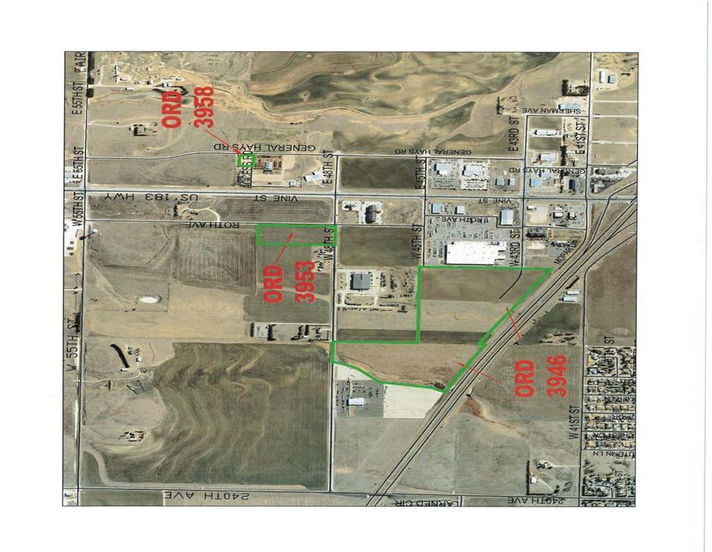
15 CITY OF HAYS AGENDA ITEM COVER SHEET COMMISSION AGENDA ITEM NO. 7 MEETING DATE: TOPIC: 2018 Boundary Resolution ACTION REQUESTED: Approve Resolution No which re-defines the boundaries, or corporate limits, of the City of Hays, Kansas. NARRATIVE: Kansas statutes require cities to pass a resolution re-defining the entire boundary line of the city whenever property is annexed into the city limits during a calendar year. The following ordinances annexed property into the city limits since the last boundary resolution was passed on December 14, 2017: Ordinance No Proposed Ottley Addition (directly west of Walmart) This annexation was approved on December 14, 2017, the same day the 2017 Boundary Resolution was approved, so this annexation is included in the 2018 Boundary Resolution. Ordinance No Crawford Addition (NW corner of 48 th and Roth Ave.) Ordinance No General Hays Road (by Hays Livestock Market) PERSON/STAFF MEMBER(S) MAKING PRESENTATION: Kim Rupp, Finance Director ADMINISTRATION RECOMMENDATION: Approval COMMITTEE RECOMMENDATION(S): N/A ATTACHMENTS: Staff Memo City Maps Showing Annexed Areas Ordinance No Ordinance No Ordinance No Resolution No
16 Commission Work Session Agenda Memo From: Brenda Kitchen, City Clerk Work Session: December 6, 2018 Subject: 2018 Boundary Resolution Person(s) Responsible: Kim Rupp, Finance Director Summary Three properties have been annexed into the City since the last boundary resolution was passed on December 14, The City Commission is asked to approve a resolution redefining the boundaries or corporate limits of the City of Hays, Kansas. Background Kansas statutes require cities to pass a resolution re-defining the entire boundary line of the City whenever property is annexed into the city limits during a calendar year. A certified copy of the resolution is filed with the county clerk, the register of deeds, and the state transportation engineer. Discussion The following ordinances annexed property into the city limits since the last boundary resolution was passed on December 14, 2017: Ordinance No Ottley Addition (directly west of Walmart) This annexation was approved on December 14, 2017, the same day the 2017 Boundary Resolution was approved, so this annexation is included in the 2018 Boundary Resolution. Ordinance No Crawford Addition (NW corner of 48 th and Roth Ave.) Ordinance No General Hays Road (by Hays Livestock Market) City Attorney John T. Bird will prepare a new resolution re-defining the city limits and it will be presented to the Commission for approval at the December 13, 2018 Commission meeting. Legal Consideration There are no known legal obstacles to proceeding as recommended by City staff. Financial Consideration There are no known financial considerations for this item. 14
17 Options The City Commission has the following options: Option 1. Approve the resolution re-defining the boundaries or corporate limits of the City of Hays, Kansas. Option 2. Provide Staff with other direction. Recommendation Staff recommends approval of a resolution which re-defines the boundaries or corporate limits of the City of Hays, Kansas. Action Requested Approve a resolution which re-defines the boundaries or corporate limits of the City of Hays, Kansas. Supporting Documentation City maps showing annexed areas Ordinance No Ordinance No Ordinance No Resolution 15
18 16
19 17
20 18
21 19
22 20
23 21
24 22
25 RESOLUTION NO A RESOLUTION RE-DEFINING THE BOUNDARIES OR CORPORATE LIMITS OF THE CITY OF HAYS, KANSAS, AS REQUIRED BY SECTION OF KANSAS STATUTES ANNOTATED. WHEREAS, the City of Hays, Kansas has added territory to said City; and WHEREAS, K.S.A requires the City of Hays, Kansas, to declare by resolution the entire boundary of the City; NOW, THEREFORE, BE IT RESOLVED BY THE GOVERNING BODY OF THE CITY OF HAYS, KANSAS: The boundary of the city is hereby fixed and defined as follows: Beginning at a point 1, feet East and feet North of the Southwest Corner of the Northwest Quarter (NW 1/4) of Section 27, Township 13 South, Range 18 West of the Sixth Principal Meridian, said point being on the East line of the Mart City First Addition to the City of Hays and feet North of the Southeast Corner of said Mart City First Addition; THENCE Northerly along the East line of said Mart City First Addition extended to the Southerly right of way line of Interstate 70, a distance of 1, feet; THENCE with an angle of 66 degrees 33 minutes 55 seconds to the left, along the South right of way line of Interstate 70, a distance of feet; THENCE with an angle of 90 degrees 00 minutes 00 seconds to the right a distance of feet to a point on the Northerly right of way line of Interstate 70; THENCE with an angle of 90 degrees 00 minutes 00 seconds to the right along the North right of way line of Interstate 70 a distance of feet; THENCE with an angle of 119 degrees 44 minutes 30 seconds to the left, along a line perpendicular to the north line of the Northwest Quarter of Section 27, Township 13 South, Range 18 West, a distance of 1, feet to a point that is feet south of the north line of Section 27; thence on an assumed bearing of South 89 degrees 10 minutes 14 seconds East, along a line parallel with and feet south of the north line of the Northwest Quarter of Section 27, a distance of feet to a point on the east line of said Northwest Quarter; thence South 89 degrees 09 minutes 58 seconds East, along a line that is parallel with and feet south of the north line of the 23
26 Northeast Quarter of Section 27, a distance of 2, feet; thence South 43 degrees 50 minutes 00 seconds East a distance of feet; thence South 01 degrees 29 minutes 58 seconds West, parallel with and feet west of the east line of said Section 27, a distance of feet; thence South 89 degrees 09 minutes 58 seconds East a distance of feet to a point on the east line of said Section 27, said point being feet south of the northeast corner of Section 27; thence South 89 degrees 00 minutes 19 seconds East a distance of feet; thence North 01 degrees 29 minutes 58 seconds East, parallel with and feet east of the west line of the Northwest Quarter of Section 26, Township 13 South Range 18 West, a distance of feet; thence North 46 degrees 14 minutes 49 seconds East a distance of feet; thence South 89 degrees 00 minutes 19 seconds East, parallel with and feet south of the north line of said Section 26, a distance of feet; thence North 01 degrees 29 minutes 58 seconds East a distance of feet to a point on the north line of said Section 26, said point being feet east of the northwest corner of said Section 26; thence North 01 degrees 31 minutes 11 seconds East a distance of feet; thence North 89 degrees 00 minutes 19 seconds West, parallel with and feet north of the south line of the Southwest Quarter of Section 23, Township 13 South Range 18 West, a distance of feet; thence North 43 degrees 44 minutes 34 seconds West a distance of feet; thence North 01 degrees 31 minutes 11 seconds East, parallel with and feet east of the west line of said Section 23, a distance of 6.50 feet; thence North 89 degrees 00 minutes 19 seconds West a distance of feet to a point on the west line of said Section 23, said point being feet north of the southwest corner of said Section 23; thence North 89 degrees 09 minutes 58 seconds West a distance of feet; thence South 01 degrees 31 minutes 11 seconds West, parallel with and feet west of the east line of the Southeast Quarter of Section 22, Township 13 South, Range 18 West, a distance of 6.50 feet; thence South 46 degrees 10 minutes 36 seconds West a distance of feet; thence North 89 degrees 09 minutes 58 seconds West, parallel with and feet north of the south line of said Southeast Quarter, a distance of feet; thence North 43 degrees 46 minutes 09 seconds West a distance of feet to a point on the west line of said Southeast Quarter, said point being feet north of the southwest corner of said Southeast Quarter; thence North 01 degrees 38 minutes 27 seconds East, along the east line of the Southwest Quarter of said Section 22, a distance of feet; thence North 89 degrees 10 minutes 14 seconds West a distance of feet; thence South 01 degrees 38 minutes 27 seconds West, parallel with and feet west of the east line of said Southwest Quarter, a distance of feet; thence South 46 degrees 24
27 14 minutes 07 seconds West a distance of feet; thence North 89 degrees 10 minutes 14 seconds West, parallel with and feet north of the south line of said Southwest Quarter, a distance of feet to the southeast corner of Block 1 of Vernie s Addition to Ellis County; THENCE South 89 degrees 12 minutes 15 seconds West, along the South line of said Block 1 of Vernie s Addition, a distance of feet to a point on the East right of way line of Sherman Avenue; THENCE North 00 degrees 47 minutes 45 seconds West, along said East right of way line, a distance of feet to the intersection of said East right of way line with the North right of way line of 43rd Street; THENCE South 89 degrees 12 minutes 15 seconds West, along the North right of way line of 43rd Street, a distance of feet to a point on the south line and feet east of the southwest comer of Lot 2, in Block 2 of the Marvin F. Braun Addition to Hays-Ellis County, Kansas; THENCE on a bearing of North, parallel with the west line of said Lot 2, a distance of feet to a point on the south line of Lot 4, in Block 2 of said Addition; THENCE South 89 degrees 12 minutes 15 seconds West, along the south line of said Lot 4, a distance of feet to a point on the East right of way line of General Hays Road; THENCE on a bearing of North, along said East right of way line, a distance of feet to the Northwest corner of Lot 6 in Block 2 of the Marvin F. Braun Addition to Hays-Ellis County, Kansas; THENCE North 89 degrees 12 minutes 15 seconds East, along the North line of said Lot 6, a distance of feet to the Northeast corner of said Lot 6; THENCE on a bearing of North a distance of feet; THENCE North 00 degrees 01 minutes 39 seconds East a distance of feet to the Southeast corner of Lot 6 in Block 3 of the North Hays Addition to Ellis County, Kansas; THENCE North 00 degrees 03 minutes 50 seconds East, along the East line of said Lot 6, a distance of feet to the Northeast corner of said Lot 6; THENCE North 89 degrees 58 minutes 10 seconds West, along the north line of Lots 5 and 6 in Block 3 of the North Hays Addition to Ellis County, Kansas, a distance of feet to a point on the East right of way line of General Hays Road; THENCE North 00 degrees 03 minutes 50 seconds East, along said East right of way line, a distance of feet to the Southwest corner of Lot 1, in Block 3 of the North Hays Addition to Ellis County, Kansas; THENCE South 89 degrees 58 minutes 10 seconds East, along the South line of said Lot 1, a distance of feet to the Southeast corner of said Lot 1; THENCE North 00 degrees 03 minutes 50 seconds East, along the East line of said Lot 1 a distance of feet to the Northeast corner of said Lot 1; THENCE North 89 degrees 58 minutes 10 seconds West, along the North line of said Lot 1, a distance of feet to the Northwest corner of said Lot 1, said point being on the East right of way line of General Hays Road; THENCE North 00 25
28 degrees 03 minutes 50 seconds East, along said East right of way line, a distance of feet; THENCE on a curve to the left, an arc distance of feet, said curve having a radius of feet, a central angle of 22 degrees 54 minutes seconds, a chord bearing of North 11 degrees 23 minutes 18 seconds West, and a chord length of feet; THENCE on a curve to the right, an arc distance of feet, said curve having a radius of feet, a central angle of 22 degrees 54 minutes seconds, a chord bearing of North 11 degrees 23 minutes 18 seconds West, and a chord length of feet; THENCE North 00 degrees 03 minutes 50 seconds East a distance of feet; THENCE North 89 degrees 10 minutes 42 seconds East, along a line parallel with and feet South of the North line of Section 22. Township 13 South, Range 18 West, adistance of feet THENCE North 00 degrees 49 minutes 18 seconds West a distance of feet to a point on the North line of said Section 22; THENCE continuing North 00 degrees 49 minutes 18 seconds West a distance of feet; THENCE South 89 degrees 10 minutes 42 seconds West a distance of feet; THENCE South 00 degrees 03 minutes 30 seconds East a distance of feet; THENCE South 89 degrees 10 minutes 42 seconds West a distance of feet to a point on the East right of way line of U.S. Highway 183; THENCE North 78 degrees 01 minutes 01 seconds West along said East right of way line, a distance of feet; thence North 00 degrees 03 minutes 39 seconds West, along the east right of way line of Highway 183, a distance of feet; thence North 27 degrees 26 minutes 16 seconds East a distance of feet; thence North 00 degrees 09 minutes 51 seconds West a distance of feet; thence North 27 degrees 29 minutes 56 seconds West a distance of feet; thence North 00 degrees 03 minutes 39 seconds West, along the east right of way line of Highway 183, a distance of feet; thence South 89 degrees 50 minutes 09 seconds West a distance of feet to a point on the west line of the Southwest Quarter of Section 15, Township 13 South, Range 18 West; THENCE South 89 degrees 50 minutes 09 seconds West a distance of feet to a point on the West right of way line of U.S. Highway 183; THENCE South 00 degrees 08 minutes 59 seconds East, along said right of way, a distance of feet to the intersection of said West right of way with the North right of way of 55th Street; THENCE South 88 degrees 58 minutes 17 seconds West, along said north right of way, a distance of feet; THENCE South 00 degrees 04 minutes 27 seconds East a distance of feet to the intersection of the North line of Section 21, Township 13 South, Range 18 West, and the West right of way of Roth Avenue extended; THENCE continuing South 00 degrees 04 minutes 27 seconds East a distance of feet to a point on the South right of way line of 55th Street; THENCE North 88 degrees 58 minutes 17 seconds East, along said South right of 26
29 way, a distance of 1.69 feet; THENCE South 01 degrees 01 minutes 43 seconds East a distance of feet; THENCE South 88 degrees 58 minutes 17 seconds West a distance of 2.47 feet; THENCE South 00 degrees 04 minutes 27 seconds East, along the West right of way of Roth Avenue, a distance of, 1, feet to the Northeast corner of the Crawford Addition to the City of Hays, Kansas; THENCE Westerly, along the North line of said Crawford Addition, a distance of feet to the Northwest corner of said Crawford Addition; THENCE Southerly, along the West line of said Crawford Addition, a distance of feet to a point on the North line of the Southeast Quarter of Section 21, Township 13 South, Range 18 West, said point being the Southwest corner of said Crawford Addition; THENCE westerly along said North line, a distance of feet to the Northwest Corner of said Southeast Quarter; THENCE on an assumed bearing 0f North 89 degrees 26 minutes 32 seconds West, along the North line of the Southwest Quarter of Section 21, Township 13 South, Range 1 West, a distance of feet; THENCE South 00 degrees 33 minutes 28 seconds West a distance of feet; THENCE South 21 degrees 02 minutes 37 seconds West a distance of feet; THENCE South 31 degrees 51 minutes 56 seconds West a distance of feet; THENCE South 45 degrees 27 minutes 10 seconds West a distance of feet; THENCE South 10 degrees 11 minutes 17 seconds West a distance of feet; THENCE South 27 degrees 04 minutes 00 seconds West a distance of feet to the North line of Interstate 70; THENCE South 64 degrees 46 minutes 16 seconds East, along the North line of Interstate 70, a distance of feet; THENCE along the North line of Interstate 70, on a curve to the right having a radius of 11, feet, an arc length of feet, a chord bearing of South 62 degrees 46 minutes 42 seconds East and a chord length of feet to the intersection of the North line of Interstate 70 and the East line of the Southwest Quarter; THENCE North 01 degrees 37 minutes 59 seconds East, along the East line of the Southwest Quarter, a distance of 88 feet more or less to the North line of the Interstate 70 Frontage Road; THENCE Southeasterly along the North line of the Interstate 70 Frontage Road, a distance of 1522 feet more or less to the Southwest Corner of Roth Third Addition; THENCE along the South line of Roth Third Addition, a distance of feet; THENCE with an angle of 90 degrees 00 minutes 00 seconds to the right a distance of feet; THENCE with an angle of 143 degrees 40 minutes 05 seconds to the left a distance of feet; THENCE with an angle of 53 degrees 41 minutes 19 seconds to the right a distance of feet; THENCE with an angle of 15 degrees 12 minutes 41 seconds to the right a distance of feet; THENCE with an angle of 22 degrees 02 minutes 09 seconds to the right a distance of feet; THENCE with an angle of 86 degrees 58 minutes 22 seconds to the 27
30 right a distance of feet to the intersection of the south right-ofway line of Interstate 70 Highway and the west right-of-way line of U.S. 183 Highway; THENCE northwesterly along the south right-ofway line of Interstate 70 Highway, approximately 720 feet; THENCE southerly feet to a point 622 feet west of the east line of Section 28; THENCE with an angle of 90N20'10" to the right, a distance of 1, feet; THENCE with an angle of 91N10'06" to the right, a distance of 1, feet to the northeast corner of the Northwest Quarter (NW/4) of Section 28; THENCE with an angle of 90N55'20" to the left along said north line, a distance of 2, feet to the Southeast Corner of Section Twenty (20); THENCE North along the East line of Section 20 a distance of feet; THENCE West on a line feet North of and parallel with the South line of said Section 20 a distance of feet to the Southeast corner of the Golden Belt Estates First Addition to the City of Hays, Kansas; THENCE North 01 degrees 09 minutes 42 seconds East along the East line of said Addition a distance of feet; THENCE North 89 degrees 58 minutes 38 seconds East a distance of feet to a point on the East line of said Section 20, said point being feet North of the Southeast corner of said Section 20; THENCE North 01 degrees 12 minutes 03 seconds East, along the East line of said Section 20 a distance of feet to a point on the South right of way line of Interstate 70; THENCE North 88 degrees 47 minutes 57 seconds West along said Interstate70 right of way, a distance of feet; thence North 06 degrees 21 minutes 57 seconds West, along said Interstate 70 right of way, a distance of 1, feet; THENCE North 65 degrees 13 minutes 54 seconds West, along said South right of way line, a distance of 1, feet to the Northwest corner of the Golden Belt Estates Third Addition; THENCE continuing North 65 degrees 13 minutes 54 seconds West, along the south right of way line of Interstate 70, a distance of feet to a point on the north line of the Southeast Quarter of said Section 20; THENCE North 68 degrees 03 minutes 03 seconds West, along the south right of way line of Interstate 70, a distance of 1, feet to a point on the west line of the Northeast Quarter of said Section 20; THENCE South 00 degrees 59 minutes 33 seconds West, along said west line, a distance of feet to the Northwest Corner of the Southeast Quarter (SE 1/4) of said Section 20; THENCE on a bearing of South 01 degrees 02 minutes 46 seconds West along the West line of the Southeast Quarter (SE 1/4) of said Section 20 a distance of 1, feet to the Northeast corner of the King s Gate First Addition; THENCE North 89 degrees 58 minutes 07 seconds West along the North line of the King s Gate First Addition, a distance of feet; THENCE with an angle of 41 degrees 32 minutes 00 seconds to the left a distance of feet; THENCE with an angle of 47 degrees 35 minutes 30 seconds to the left a distance of feet; THENCE West (
31 feet North of and parallel with the South line of said Southwest quarter of Section 20) a distance of feet; THENCE North a distance of feet; THENCE westerly a distance of feet to a point feet North of the South line of said Southwest quarter; THENCE South feet to a point feet East of the Southwest corner of said Southwest Quarter and on the South line of said Southwest Quarter of Section 20; THENCE on an assumed bearing of North 88 degrees 42 minutes 49 seconds East along the North line of the Northwest quarter of Section 29, Township 13 South; Range 18 West a distance of feet; THENCE on a bearing of South 00 degrees 14 minutes 26 seconds East a distance of feet to the South right of way line of 41st Street and the Northwest Corner of Lot 5, Block 1 of the Second Replat of a Portion of Westridge Addition to Ellis County, Kansas; THENCE continuing on the last described course along the West line of Lots 4 and 5, Block 1 of said addition a distance of feet to the Southwest Corner of Lot 4, Block 1 of said addition; THENCE on a bearing of South 88 degrees 42 minutes 55 seconds West along the North line of Lot 2, Block 1 of said addition, a distance of feet to the Northwest Corner of said Lot 2; THENCE on a bearing of South 01 degrees 15 minutes 57 seconds East along the West line of said Lot 2 a distance of feet to the North right of way line of 38th Street; THENCE on a bearing of North 88 degrees 42 minutes 49 seconds East along the North line of said 38th Street a distance of 9.91 feet; THENCE on a curve to the right having a radius of feet, a chord bearing of South 75 degrees 31 minutes 06 seconds East, a chord length of feet, an arc length of feet to the South line of Lot 2, Block 1 of said addition; THENCE on a bearing of North 88 degrees 42 minutes 50 seconds East along the South line of Lot 2, Block 1 of said addition a distance of feet to the West line of Lot 2, Block 2 of said addition; THENCE on a bearing of South 00 degrees 14 minutes 26 seconds East along the West line of Lot 2 and 3, Block 2 of said addition a distance of feet to the North right of way line of 37th Street and the Southwest Corner of Lot 3, Block 2 of said addition; THENCE continuing on the last described course a distance of feet to a point on the East-West sixteenth line of the Northwest Quarter of Section 29, township 13 South, Range 18 West; THENCE West along said sixteenth line a distance of feet; thence South, parallel with the West line of said Northwest Quarter, a distance of 1, feet to a point on the South line of said Northwest Quarter, said point being feet East of the Southwest corner of said Northwest Quarter; THENCE West along South line of said Northwest Quarter a distance of feet to the Northwest comer of the DK Ranch Addition to the City of Hays, Kansas; THENCE South 00 degrees 35 minutes 28 seconds West a distance of feet; THENCE North 89 degrees 24 minutes 32 seconds West 29
32 a distance of feet; THENCE on a curve to the left, an arc distance of feet, said curve having a radius of feet, a central angle of 162 degrees 44 minutes 12 seconds, a chord length of feet and a chord bearing of South 09 degrees 13 minutes 22 seconds West; THENCE on a curve to the left, an arc distance of feet, said curve having a radius of feet, a central angle of 23 degrees 47 minutes 58 seconds, a chord length of feet and a chord bearing of South 12 degrees 42 minutes 40 seconds East; THENCE South 24 degrees 36 minutes 40 seconds East a distance of feet; THENCE on a curve to the right, an arc distance of feet, said curve having a radius of feet, a central angle of 25 degrees 12 minutes 08 seconds, a chord length of feet and a chord bearing of South 12 degrees 00 minutes 36 seconds East; THENCE South 00 degrees 35 minutes 28 seconds West a distance of feet; THENCE South 89 degrees 09 minutes 17 seconds West a distance of feet to a point on the east right of way line of U.S. Highway 183 Alternate; THENCE South 00 degrees 50 minutes 43 seconds East, along said right of way, a distance of feet; THENCE South 03 degrees 01 minutes 18 seconds East, along said right of way, a distance of feet; THENCE South 02 degrees 53 minutes 57 seconds East, along said right of way, a distance of feet; THENCE North 89 degrees 36 minutes 52 seconds East a distance of 1, feet to a point on the east line of the West Half of the Southwest Quarter of Section 29, Township 13 South, Range 18 West; THENCE North 00 degrees 35 minutes 28 seconds East, along the east line of said West Half of the Southwest Quarter, a distance of feet; THENCE on a curve to the left, an arc distance of feet, said curve having a radius of feet, a central angle of 01 degrees 08 minutes 20 seconds, a chord length of feet and a chord bearing of South 89 degrees 53 minutes 14 seconds West; THENCE South 88 degrees 48 minutes 15 seconds West a distance of feet; THENCE North 00 degrees 35 minutes 28 seconds East a distance of feet; THENCE North 89 degrees 37 minutes 13 seconds East a distance of feet to a point on the east line of said West Half of the Southwest Quarter; THENCE North 00 degrees 35 minutes 28 seconds East, along the east line of said West Half of the Southwest Quarter, a distance of feet to the northeast corner of said West Half of the Southwest Quarter; thence North along the North-South sixteenth line of the Northwest Quarter of said Section 20, a distance of 1, feet to a point on the South right of way line of 37th Street; thence East along said right of way line a distance of feet to the Southeast Corner of said Second Replat of a Portion of Westridge Addition; THENCE on a bearing of North 00 degrees 14 minutes 26 seconds West along the East line of said addition a distance of feet; THENCE East feet South of and parallel with the North line of the Northwest quarter of 30
33 Section 29, Township 13 South, Range 18 West a distance of feet to the East line of said Northwest quarter of Section 29; THENCE Southerly along the East line of the Northwest quarter of said Section 29 a distance of feet to the Southeast corner of the Northwest quarter of said Section 29; THENCE west along the north line of the Southwest Quarter (SW/4) of Section 29, a distance of 1, feet to the Northeast Corner of Country Club Estates Sixth Addition to the City of Hays; THENCE continuing along the last described course along the North line of said Country Club Estates Sixth Addition a distance of feet to the centerline of Columbine Drive; THENCE on a bearing of South 00 degrees 00 minutes 17 seconds West along the centerline of said Columbine Drive a distance of feet; THENCE on a curve to the left along said centerline, having a radius of feet, a chord bearing of South 15 degrees 59 minutes 10 seconds East, a chord length of feet, an arc distance of feet; THENCE on a curve to the right along said centerline having a radius of feet, a chord bearing of South 00 degrees 03 minutes 16 seconds West, a chord length of feet, an arc distance of feet; THENCE on a bearing of South 32 degrees 05 minutes 23 seconds West along said centerline a distance of feet; THENCE on a curve to the left along said centerline having a radius of feet, a chord bearing of South 16 degrees 32 minutes 24 seconds West, a chord length of feet, an arc distance of feet; THENCE on a bearing of South 00 degrees 59 minutes 22 seconds West along said centerline a distance of feet; THENCE on a bearing of South 89 degrees 00 minutes 38 seconds East a distance of feet to the East right of way line of said Columbine Drive; THENCE continuing on the last described course a distance of feet; THENCE with an angle of 56 degrees 08 minutes 37 seconds to the right a distance of feet; THENCE with an angle of 60 degrees 54 minutes 44 seconds to the left a distance of feet; THENCE with an angle of 29 degrees 56 minutes 20 seconds to the right a distance of feet; THENCE with an angle of 90 degrees 00 minutes 00 seconds to the right to the initial tangent of a curve to the left having a radius of feet, an arc distance of feet; THENCE Southerly tangent to said curve a distance of feet to the South line of the Southwest Quarter (SW 1/4) of Section 29; THENCE with an angle of 90 degree 00 minutes 00 seconds to the left along said South line a distance of feet to a point feet West of the Northeast Corner of Section 32; THENCE southerly, a distance of approximately 2, feet to a point 1, feet west of the east line of Section 32 and feet north of the south line of the Northeast Quarter (NE/4) of Section 32; THENCE westerly parallel with said south line, a distance of feet; THENCE south parallel with the east line of Section 32, to the northerly line of 13th Street 31
34 extended; THENCE northwesterly along the northerly line of 13th Street extended, to intersect the center line of Big Creek; THENCE southerly along the center line of Big Creek to the point said center line intersects the south line of the Northeast Quarter (NE/4) of Section 32; THENCE west along said south line, to the point said south line intersects the northerly line of 12th Street extended; THENCE Southeasterly along said northerly line to intersect the center line of Big Creek; THENCE southerly along the center line of Big Creek to the point of intersection of the center line of Big Creek and the south right-of-way of the Union Pacific Railroad; THENCE on a bearing of North 59 degrees 00 minutes 39 seconds West along said South railroad right of way a distance of feet; THENCE on a bearing of South 40 degrees 04 minutes 21 seconds West a distance of feet to the South Old Highway 40 permanent easement line; THENCE on a bearing of North 59 degrees 00 minutes 39 seconds West along said South permanent easement line a distance of feet to the South Old Highway 40 right -of-way line; THENCE on a bearing of North 78 degrees 45 minutes 51 seconds West along said Highway right of way line a distance of feet; THENCE on a bearing of South 82 degrees 45 minutes 43 seconds West along said Highway right of way line a distance of feet to the easterly right of way line of U.S. Highway 183 Alternate; THENCE on a bearing of South 19 degrees 23 minutes 51 seconds East along the said Easterly highway right of way line a distance of feet; THENCE on a bearing of South 27 degrees 57 minutes 37 seconds East along said Easterly right of way line a distance of feet; THENCE on a curve to the left having a radius of feet, a chord bearing of South 37 degrees 42 minutes 46 seconds East a chord length of feet, an arc distance of feet to the Westerly line of the Fort Hays Historical Park; THENCE on a bearing of South 36 degrees, 51 minutes 35 seconds West along said Westerly line of Fort Hays Historical Park Extended a distance of feet to the centerline of U.S. Highway 183 Alternate; THENCE easterly, along said centerline, on a curve to the left, the initial tangent of which is at an angle of 84N27'20" to the left of the last described course and having a radius of 2, feet, an arc distance of 2, feet; THENCE east along said centerline, a distance of 2, feet, to the centerline of Big Creek; THENCE with an angle of 78N54'05" to the right along the centerline of Big Creek, a distance of feet; THENCE with an angle of 10N14'48" to the left, a distance of feet; THENCE with an angle of 8N59'39" to the right, a distance of feet; THENCE with an angle of 77N43'02" to the left, a distance of feet; THENCE with an angle of 66N31'34" to the left, a distance of feet; THENCE with an angle of 27N53'22" to the right, a distance of feet; THENCE 32
35 with an angle of 36N55'29" to the left, a distance of feet; THENCE with an angle of 34N16'16" to the right, a distance of feet; THENCE with an angle of 55N33'32" to the right, a distance of feet, to the intersection of the centerline of Big Creek and the centerline of Montgomery Street Drainage Ditch; THENCE northerly with an angle of 98N29'47" to the left, a distance of feet, to the intersection of the centerline of Montgomery Street Drainage Ditch and the centerline of U.S. Highway 183 Alternate; THENCE with an angle of 90N51'44" to the right along the centerline of U.S. Highway 183 Alternate, a distance of feet; THENCE with an angle of 83N54'10" to the left, a distance of feet to the northerly line of the Fort Hays Military Reservation; THENCE southeasterly with an angle of 109N51'00" to the right along the said Fort Hays Military Reservation line to the intersection of said reservation line and the south right-of-way line of U.S. Highway 183 Alternate; THENCE easterly along the south right-ofway line of U.S. Highway 183 Alternate, feet; THENCE southeasterly, a distance of 108 feet; THENCE east perpendicular to the east line of Section 4, a distance of 30 feet; THENCE south along the east line of said Section 4, a distance of feet to the north line of the Fort Hays Military Reservation; THENCE on an assumed bearing of South 56 degrees 54 minutes East along the said Fort Hays Military Reservation line a distance of feet; THENCE South 34 degrees 18 minutes West a distance of feet; THENCE North 87 degrees 25 minutes West, a distance of feet; THENCE South 03 degrees 46 minutes East a distance of feet along the East right of way line of U.S. 183 Highway; THENCE South 08 degrees 07 minutes West, a distance of feet along said right of way; THENCE South 02 degrees 13 minutes West, a distance of feet along said right of way; THENCE South 87 degrees 47 minutes East, a distance of feet; THENCE on a curve of 1, feet radius to the right, an arc distance of feet with a chord which bears South 67 degrees 30 minutes East, a chord length of feet; THENCE South 47 degrees 12 minutes East, a distance of feet; THENCE North 50 degrees 07 minutes East, a distance of feet; THENCE North 01 degree 46 minutes East, a distance of 2, feet to a point on the Northerly line of the Fort Hays Military Reservation; THENCE North 56 degrees 54 minutes West, a distance of feet; THENCE North parallel with the East line of Section 4, Township 14 South, Range 18 West, a distance of 32 feet; THENCE southeasterly parallel to the Fort Hays Military Reservation line, a distance of 1, feet to the west edge of Chetolah Creek right-of-way; THENCE south, along the west edge of Chetolah Creek right-of-way to the center line of Reservation Road; THENCE southeasterly along the center line of Reservation Road to 33
36 the center line of Chetolah Creek; THENCE southeasterly on a line perpendicular to the center line of Chetolah Creek a distance of feet to a point on the east right-of-way of Chetolah Creek; THENCE northeasterly along the east Chetolah Creek right-of-way on an assumed bearing of North 41 degrees 40 minutes 00 seconds East a distance of feet to a point of tangency; THENCE continuing along the east right-of-way line of Chetolah Creek on a curve to the left having a radius of feet, an arc distance of feet to the intersection of the east right-of-way of Chetolah Creek and the east line of the Southeast Quarter of Section 3, Township 14 South, Range 18 West; THENCE continuing on the last described course along the east right-of-way line of Chetolah Creek on an arc distance of feet to the Southwest corner of Lot 2, Block 1 of the Southridge Estates Addition; THENCE east along the south line of said Lot 2, a distance of feet to the Southeast corner of said Lot 2; THENCE north along the east line of said Southridge Estates Addition, a distance of feet to a point on the southerly right-of-way of the old U.S. Highway 40 Bypass; THENCE North 81 degrees 01 minutes 00 seconds West along said right-of-way a distance of feet; THENCE south a distance of feet; THENCE west a distance of feet to a point on the east right-of-way of Chetolah Creek; THENCE north along the east Chetolah Creek right-of-way, a distance of feet to a point of tangency; THENCE continuing on the east Chetolah Creek right-ofway on a curve to the right having a radius of feet, an arc distance of feet to a point of tangency; THENCE northeasterly along the east Chetolah Creek right-of-way, a distance of feetto a point of tangency; THENCE continuing on the east Chetolah Creek right-of-way on a curve to the left having a radius of feet, an arc distance of feet to a point of tangency; THENCE northwesterly along the east Chetolah Creek right-of-way, a distance of feet; THENCE at an angle of 58N45'34" to the right and parallel to the east line of the Northwest Quarter (NW/4) of Section 3, Township 14 South, Range 18 West, a distance of 2, feet to a point 50 feet south of the north line of the Northwest Quarter (NW/4) of Section 3; THENCE east parallel with the north line of the Northwest Quarter (NW/4) of Section 3, a distance of feet; THENCE with an angle of 0N0'18" to the left, parallel with the north line of the Northeast Quarter (NE/4) of Section 3, a distance of feet; THENCE with an angle of 90N00'00" to the right, a distance of feet; THENCE with an angle of 90N00'00" to the left, a distance of feet; THENCE with an angle of 90N00'00" to the right, a distance of feet; THENCE with an angle of 90N00'00" to the left on a line parallel with the north line of Section 3, a distance of 1, feet; THENCE with an angle of 90N00'00" 34
ORDINANCE NO AN ORDINANCE MAKING CERTAIN FINDINGS AND ESTABLISHING THE MALL REDEVELOPMENT DISTRICT
 Introduced: January 20, 2015 Passed: January 20, 2015 Published: January 23, 2015 ORDINANCE NO. 2015-2 AN ORDINANCE MAKING CERTAIN FINDINGS AND ESTABLISHING THE MALL REDEVELOPMENT DISTRICT WHEREAS, K.S.A.
COUNCIL COMMUNICATION
 Meeting Date: March 20, 2018 COUNCIL COMMUNICATION Agenda Item: Agenda Location: Action Items Work Plan # Legal Review: 1 st Reading 2 nd Reading Subject: A resolution approving the final design for the
ORDINANCE NO CITY OF MONTICELLO ADOPTING TAX INCREMENT FINANCING TAX INCREMENT FINANCING DISTRICT II
 ORDINANCE NO. 2006-59 CITY OF MONTICELLO ADOPTING TAX INCREMENT FINANCING TAX INCREMENT FINANCING DISTRICT II WHEREAS, the City of Monticello, Illinois, desires to adopt tax increment financing pursuant
ORDINANCE NO. ASMT-3189
 ORDINANCE NO. ASMT-3189 AN ORDINANCE LEVYING ASSESSMENTS ON LOTS, PIECES AND PARCELS OF GROUND FOR THE PURPOSE OF PAYING THE COST FOR THE CONSTRUCTION OF A FLOOD CONTROL PROJECT ALONG NEGRO CREEK BETWEEN
RESOLUTION OF ADVISABILITY AND AUTHORIZATION NO. 7841
 1 2 3 4 5 6 7 8 9 10 11 12 13 14 15 16 17 18 19 20 21 22 23 24 25 26 27 28 29 30 31 32 33 34 35 (Published in the Topeka Metro News August 9, 2006) RESOLUTION OF ADVISABILITY AND AUTHORIZATION NO. 7841
Village of Bedford Park ) ) SS County of Cook ) REVISED NOTICE TO SOLICIT PROPOSALS
 ) SS County of Cook ) REVISED NOTICE TO SOLICIT PROPOSALS") Village of Bedford Park ) ) SS County of Cook ) REVISED NOTICE TO SOLICIT PROPOSALS Notice is hereby given the Village of Bedford Park, Cook County, Illinois is soliciting proposals for the sale of real
Village of Bedford Park ) ) SS County of Cook ) REVISED NOTICE TO SOLICIT PROPOSALS Notice is hereby given the Village of Bedford Park, Cook County, Illinois is soliciting proposals for the sale of real
SPECIAL USE PERMIT - SUP Metcalf Avenue
 NOTICE OF PUBLIC HEARING CITY PLANNING COMMISSION CITY OF OVERLAND PARK, KANSAS Notice is hereby given that the City Planning Commission of Overland Park, Kansas, will hold a public hearing Monday, March
ORDINANCE NO. SB-3131
 ORDINANCE NO. SB-3131 AN ORDINANCE MAKING FINDINGS AND ESTABLISHING A STAR BOND PROJECT DISTRICT WITHIN THE CITY OF OVERLAND PARK, KANSAS PURSUANT TO K.S.A. 12-17,160 ET SEQ., AS AMENDED (BLUHAWK STAR
when the following proceedings, among others were held and done, to-wit:
 STATE OF COLORADO ) COUNTY OF ADAMS ) At a regular meeting of the Board of County Commissioners for Adams County, Colorado, held at the Administration Building in Brighton, Colorado on the 22 nd day of
SEWER CONNECTION FEES
 100.01 Connection Fees Required 100.04 Establishment of Sewer Districts 100.02 East Sanitary Sewer District 100.05 East Southside Drive Sewer Connection District 100.03 West Sanitary Sewer District 100.01
City of East Moline Committee of the Whole
 City of East Moline Committee of the Whole City Council Chambers 915 16 th Avenue East Moline, IL 61244 DATE: Monday, May 5 th, 2014 TIME: Immediately Following the Regular Council Meeting 1 Enterprise
City Council Meeting 8. B. Meeting Date: 09/08/2015. Agenda Category: New Business. Subject: Establishment of a STAR Bond Project District
 City Council Meeting 8. B. Meeting Date: 09/08/2015 Submitted By: Kathy Sexton, City Manager Agenda Category: New Business Subject: Establishment of a STAR Bond Project District Guests: Korb Maxwell, Attorney,
NOTICE OF PUBLIC HEARING
 NOTICE OF PUBLIC HEARING Notice is hereby given that the first and second public hearing of a proposed annexation area described below will be held by the City Council of the City of Rockport, Texas, at
CHAPTER House Bill No. 1311
 CHAPTER 2017-216 House Bill No. 1311 An act relating to the Lehigh Acres Municipal Services Improvement District, Lee and Hendry Counties; amending chapter 2015-202, Laws of Florida; expanding the territorial
CHAPTER House Bill No. 1495
 CHAPTER 2000-419 House Bill No. 1495 An act relating to Acme Improvement District, Palm Beach County; amending chapter 28557, Laws of Florida, 1953, as amended; expanding the boundaries of said district,
MINUTES OF A MEETING OF THE GOVERNING BODY OF THE CITY OF HAYS, KANSAS HELD ON JULY 10, 2014
 MINUTES OF A MEETING OF THE GOVERNING BODY OF THE CITY OF HAYS, KANSAS HELD ON JULY 10, 2014 1. CALL TO ORDER BY CHAIRMAN: The Governing Body of the City of Hays, Kansas met in regular session on Thursday,
ORDINANCE NO
 ORDINANCE NO. 2008-0390 AN ORDINANCE OF THE CITY OF NEWCASTLE, WASHINGTON, DECLARING PUBLIC USE AND NECESSITY RELATED TO REAL PROPERTY TO BE CONDEMNED AS REQUIRED FOR A MUNICIPAL PROJECT KNOWN AS THE NEWCASTLE
MEMORANDUM OF LEASE RECITALS
 MEMORANDUM OF LEASE THE STATE OF TEXAS COUNTY OF HARRIS THIS MEMORANDUM OF LEASE (this "Memorandum") is made and entered into effective as of the 17th day of May, 2001, by and between HARRIS COUNTY SPORTS
Starting Bid: $15,000
 Starting Bid: $15,000 Parcel # 12.00593.00 Garage Legal Description Information Lot-005 Block-006 FOREST EDGE ADDITION Eckles Township 20 147 34 Forfeited: 06-222018 Deeded acres: 1.33 Appraised Value
FIRST AMENDMENT TO METRO NORTH CROSSING TAX INCREMENT FINANCING PLAN
 FIRST AMENDMENT TO METRO NORTH CROSSING TAX INCREMENT FINANCING PLAN KANSAS CITY, MISSOURI TIF COMMISSION APPROVAL: 12/13/17 12-2-17 DATE RESOLUTION NO. CITY COUNCIL APPROVAL: 2/1/18 180020 DATE ORDINANCE
CITY OF GAYLORD RESOLUTION NUMBER TOWN OF DRYDEN SIBLEY COUNTY, MINNESOTA CITY OF GAYLORD SIBLEY COUNTY, MINNESOTA
 CTY OF GAYLORD RESOLUTON NUMBER TOWN OF DRYDEN SBLEY COUNTY, MNNESOTA CTY OF GAYLORD SBLEY COUNTY, MNNESOTA N THE MATTER OF THE ORDERLY ANNEXATON BETWEEN THE CTY OF GAYLORD DRYDEN TOWNSHP PURSUANT TO MNNESOTA
City of Chicago O Office of the City Clerk. Document Tracking Sheet
 City of Chicago Office of the City Clerk O2019-2185 Document Tracking Sheet Meeting Date: Sponsor(s): Type: Title: Committee(s) Assignment: 3/13/2019 Emanuel (Mayor) Ordinance Adoption of Tax Increment
ORDINANCE NO AMENDMENT TO THE CITATION ESTATES MPD DEVELOPMENT AGREEMENT
 ORDINANCE NO. 2015- AMENDMENT TO THE CITATION ESTATES MPD DEVELOPMENT AGREEMENT AN ORDINANCE OF THE CITY COUNCIL OF THE CITY OF PALM COAST, FLORIDA, PROVIDING FOR THE SECOND AMENDED AND RESTATED MASTER
AGENDA BILL. Beaverton City Council Beaverton, Oregon FOR AGENDA OF: ~1-8 BILL NO: BUDGET IMPACT
 AGENDA BILL SUBJECT: An Ordinance Withdrawing Territory From The Tualatin Valley Water District and Declaring An Emergency Beaverton City Council Beaverton, Oregon 3-27-18 FOR AGENDA OF: ~1-8 BILL NO:
M I N U T E S OKLAHOMA COUNTY PLANNING COMMISSION
 M I N U T E S OKLAHOMA COUNTY PLANNING COMMISSION September 21, 2000 1:30 P.M. The meeting of the Oklahoma County Planning Commission convened and was called to order by Ms. Cheryl Dorrance, at 1:30 P.M.,
EXHIBIT A LEGAL DESCRIPTION OF AVIGATION EASEMENT Being that certain real property situate in the unincorporated area of the County of Monterey, State
 EXHIBIT A LEGAL DESCRIPTION OF AVIGATION EASEMENT Being that certain real property situate in the unincorporated area of the County of Monterey, State of California, described as follows: Being a portion
BOARD OF ALDERMEN AGENDA
 NOTICE OF MEETING CITY OF BRANSON BOARD OF ALDERMEN Special Meeting Thursday, March 10, 2016 5:00 p.m. Council Chambers Branson City Hall 110 W. Maddux Meeting Called to Order Roll Call AGENDA REGULAR:
CHAPTER House Bill No. 1509
 CHAPTER 2006-358 House Bill No. 1509 An act relating to Flagler Estates Road and Water Control District, St. Johns County; amending chapter 98-529, Laws of Florida; providing additional powers of the district
All of Lot 5, Except the North 783 feet, Wolf Creek Acres, a subdivision of land in the City of Overland Park, Johnson County, Kansas.
 NOTICE OF PUBLIC HEARING CITY PLANNING COMMISSION CITY OF OVERLAND PARK, KANSAS Notice is hereby given that the City Planning Commission of Overland Park, Kansas, will hold a public hearing Monday, January
A G E N D A OKLAHOMA COUNTY PLANNING COMMISSION. November 16, Approval of Minutes of the Previous Meeting: (October 19, 2006)
") A G E N D A OKLAHOMA COUNTY PLANNING COMMISSION ROOM 103 1:30 p.m. November 16, 2006 1. Notice of meeting posted November 9, 2006. 2. Call to Order. 3. Roll Call. 4. Approval of Minutes of the Previous
A G E N D A OKLAHOMA COUNTY PLANNING COMMISSION ROOM 103 1:30 p.m. November 16, 2006 1. Notice of meeting posted November 9, 2006. 2. Call to Order. 3. Roll Call. 4. Approval of Minutes of the Previous
PUBLIC NOTICE: TO ALL CONCERNED CITIZENS OF HIALEAH GARDENS, FLORIDA. NOTICE TO BE POSTED AT CITY HALL.
 Mayor Yioset De La Cruz City Council Members Chairman Luciano Lucky García Vice Chairman Rolando Roly Piña Council member Jorge A. Merida Council member Jorge Gutierrez Council member Elmo L. Urra PUBLIC
DANE COUNTY ORDINANCE AMENDMENT NO: Internal Tracking Number: RECU25760
 DANE COUNTY ORDINANCE AMENDMENT NO: 10246 Internal Tracking Number: RECU25760 Amending Section 10.03 relating to Zoning Districts in the Town of Vienna. The Dane County Board of Supervisors does ordain
CHAPTER House Bill No. 1213
 CHAPTER 2015-198 House Bill No. 1213 An act relating to the West Palm Beach Water Catchment Area, Palm Beach County; amending chapter 67-2169, Laws of Florida, as amended; revising boundaries; providing
BEFORE THE BOARD OF COUNTY COMMISSIONERS FOR THE COUNTY OF TILLAMOOK IN THE STATE OF OREGON ) )
 )") COUN1Y COOID'JOlJIINAI_ AFTER RECORDING RETURN TO AND SEND ALL TAX STATEMENTS TO: Tillamook County 201 Laurel Avenue Tillamook, OR 97141 Tillamook County, Oreqon 2014 002077 051091201408:17:08AM - DEED-ORDER
COUN1Y COOID'JOlJIINAI_ AFTER RECORDING RETURN TO AND SEND ALL TAX STATEMENTS TO: Tillamook County 201 Laurel Avenue Tillamook, OR 97141 Tillamook County, Oreqon 2014 002077 051091201408:17:08AM - DEED-ORDER
Downum Title Services, Inc. TITLE REPORT Work Order #6581
 17030 Main Street South Blountstown, Florida 32424 Downum Title Services, Inc. JUDY DOWNUM Telephone: (850) 674-3533 Fax: (850) 674-1343 TITLE REPORT Work Order #6581 FOR GULF COUNTY TAX COLLECTOR 1000
EXHIBIT A LEGAL DESCRIPTION OF PROPERTY TO BE INCLUDED IN THE DISTRICT
 - - - - EXHIBIT A LEGAL DESCRIPTION OF PROPERTY TO BE INCLUDED IN THE DISTRICT COMMUNITY FACILITIES DISTRICT FOR QUAILWOOD AND ROUWENHORST LEGAL DESCRIPTION JULY 28, 2004 A PORTION OF LAND LYING WITHIN
CANADA PROVINCE OF BRITISH COLUMBIA
 Note: This supplementary Letters Patent has been consolidated from the Supplementary Letters Patents of the three Regional Districts of the Okanagan valley: North Okanagan Regional District; Central Okanagan
ORDINANCE ORDINANCE ANNEXING PROPERTY TSM GREENBRIER LLC
 ORDINANCE 2018-7 ORDINANCE ANNEXING PROPERTY TSM GREENBRIER LLC RECITALS WHEREAS, the City ofbuffalo has received a Petition for Annexation by Ordinance from TSM Greenbrier LLC for the annexation of97
FEASIBILITY REPORT STORM DRAINAGE IMPROVEMENTS TERRACE AND METCALF CITY OF OVERLAND PARK JOHNSON COUNTY, KANSAS
 March 2, 2011 FEASIBILITY REPORT STORM DRAINAGE IMPROVEMENTS STANLEY STORM DRAINAGE IMPROVEMENTS, 151sT TERRACE AND METCALF CITY OF OVERLAND PARK JOHNSON COUNTY, KANSAS DESCRIPTION: This report relates
Regular Meeting Agenda Tuesday, April23, :00 pm McAlester City Hall - Council Chambers 28 E. Washington
 McAlester City Council NOTICE OF MEETING Regular Meeting Agenda Tuesday, April23, 2013-6:00 pm McAlester City Hall - Council Chambers 28 E. Washington Steve Harrison... Mayor Weldon Smith...............
MAPPING DESCRIPTIONS AND DRAFTING PARCEL BOUNDARIES FOR CADASTRAL MAPPING
 MAPPING DESCRIPTIONS AND DRAFTING PARCEL BOUNDARIES FOR CADASTRAL MAPPING Chapter 6 2015 Cadastral Mapping Manual 6-0 Another method of describing land, aside from the fractional section method, is called
IN THE CIRCUIT COURT OF PULASKI COUNTY, ARKANSAS FIFTH DIVISION. REGIONS BANK, an Alabama banking corporation
 IN THE CIRCUIT COURT OF PULASKI COUNTY, ARKANSAS FIFTH DIVISION REGIONS BANK, an Alabama banking corporation PLAINTIFF v. Case No. 60CV-2012-4668 ARRINGTON APTS II, LIMITED PARTNERSHIP, an Arkansas limited
City of Crowley Special Council Meeting Notice:
 CITY OF CROWLEY SPECIAL COUNCIL MEETING NOVEMBER 5, 2003 The Mayor and Board of Aldermen of the City of Crowley, Louisiana, the governing authority of the City of Crowley, met in a special session at 6:00
CB TO AUTHORIZE THE CHIEF TO PLACE PROPERTY IN BRYAN COUNTY IN TRUST STATUS WITH THE UNITED STATES OF AMERICA
 CB- 141-16 TO AUTHORIZE THE CHIEF TO PLACE PROPERTY IN BRYAN COUNTY IN TRUST STATUS WITH THE UNITED STATES OF AMERICA IN THE TRIBAL COUNCIL OF THE CHOCTAW NATION ANTHONY DILLARD INTRODUCED THE FOLLOWING
CHAPTER House Bill No. 655
 CHAPTER 2016-248 House Bill No. 655 An act relating to the City of Jacksonville, Duval County; amending chapter 87-471, Laws of Florida, as amended; establishing special zones in downtown Jacksonville;
September 18, Mr. Matthew Morris Kolter Acquisitions, LLC 6981 Professional Parkway E. Sarasota, Florida Dear Mr.
 JIM C. STUDIALE Director Community Development Department September 18, 2014 Mr. Matthew Morris Kolter Acquisitions, LLC 6981 Professional Parkway E. Sarasota, Florida 34240 RE: Minor Modification of PUD
EXHIBIT 314B TRACT I
 - 2878 EXHIBIT 314B 122312 PRESTON CENTER SPECIAL PURPOSE DISTRICT TRACT BOUNDARY DESCRIPTIONS TRACT I BEING all of City Block 1/5625 and is further described as being a tract of land beginning at a point
CITY OF ZUMBROTA ORDINANCE NO
 CTY OF ZUMBROTA ORDNANCE NO 272 AN ORDNANCE OF THE CTY OF ZUMBROTA MNNESOTA ANNEXNG LAND LOCATED N ZUMBROTA TOWNSlllP GOODHUE COUNTY MNNESOTA PURSUANT TO MNNESOTA STATUTES 4433 SUBDVSON 2(3) PERMTTNG ANNEXATON
Descriptor term: Descriptor code: Issue date: SECTION A ORGANIZATION PLAN
 SECTION A ORGANIZATION PLAN A.1...DISTRICT LEGAL STATUS A.2...DISTRICT LEGAL DESCRIPTION A.3...ORGANIZATION PLAN A.4...ORGANIZATIONAL CHART A.5...SCHOOL ATTENDANCE AREAS A.6...SCHOOL CALENDAR DISTRICT
SUMMARY: The Principal Deputy Assistant Secretary- Indian Affairs made a final agency
 (4337-15-P) DEPARTMENT OF THE INTERIOR Bureau of Indian Affairs [178A2100DD/AAKC001030/AOA501010.999900 253G] Land Acquisitions; Wilton Rancheria AGENCY: ACTION: Bureau of Indian Affairs, Interior. Notice.
Planning & Zoning Commission
 Preliminary Plat Westwood, Section 3 Planning & Zoning Commission Planning & Development Department March 21, 2016 Request Subdivide approximately 38.1 acres of previously unplatted property to create
(Use this form to file a local law with the Secretary of State.)
") Local Law Filing NEW YORK'STATE DEPARTMENT OF STATE 41 STATE STREET, ALBANY, NY 12231 (Use this form to file a local law with the Secretary of State.) Text = of law should be given as amended. Do not include
Local Law Filing NEW YORK'STATE DEPARTMENT OF STATE 41 STATE STREET, ALBANY, NY 12231 (Use this form to file a local law with the Secretary of State.) Text = of law should be given as amended. Do not include
APPROVED BY REVIEW COMMITTEE April 13, 2015
 APPROVED BY REVIEW COMMITTEE April 13, 2015 CARLTON LANDING ECONOMIC DEVELOPMENT PROJECT PLAN PREPARED BY: THE TOWN OF CARLTON LANDING, OKLAHOMA JOANNE CHINNICI, MAYOR JEFF CLICK, TOWN TRUSTEE RICHARD
AN ORDINANCE ANNEXING CERTAIN LANDS TO THE CITY OF THIEF RIVER FALLS. THE CITY COUNCIL OF THIEF RIVER FALLS, MINNESOTA, ORDAINS:
 DEC 9 ORDNANCE NO. 102, 2ND SERES AN ORDNANCE ANNEXNG CERTAN LANDS TO THE CTY OF THEF RVER FALLS. THE CTY COUNCL OF THEF RVER FALLS, MNNESOTA, ORDANS: Section 1. WHEREAS, The sole owners of the following
POLK CITY. City Commission Meeting May 21, 2018 Polk City Government Center 7:00 P.M. 123 Broadway Blvd., SE
 POLK CITY City Commission Meeting May 21, 2018 Polk City Government Center 7:00 P.M. 123 Broadway Blvd., SE CALL TO ORDER Mayor Joe LaCascia INVOCATION Pastor Walter Lawlor, New Life Community Church PLEDGE
ORDINANCE NO WHEREAS, An Eighty (80) foot portion of Sheffield Avenue lies between the
 foot portion of Sheffield Avenue lies between the") SPONSOR: Councilman Mark Kalwinski 1 st District Councilman PETITIONED BY: Hammond Port Authority ORDINANCE NO. 9284 AN ORDINANCE VACATING AN EIGHTY (80) FOOT PORTION OF SHEFFIELD AVENUE LYING BETWEEN
SPONSOR: Councilman Mark Kalwinski 1 st District Councilman PETITIONED BY: Hammond Port Authority ORDINANCE NO. 9284 AN ORDINANCE VACATING AN EIGHTY (80) FOOT PORTION OF SHEFFIELD AVENUE LYING BETWEEN
Public Comment Period/Council Comments. Public Hearing: FY 2016 Final Budget Hearing. Resolution No. 669, FY 2016 Mill Levy
 Public Comment Period/Council Comments Public Hearing: FY 2016 Final Budget Hearing Town of West Yellowstone Special Town Council Meeting Tuesday, September 8, 2015 West Yellowstone, Montana Town Hall,
BE IT ORDAINED BY THE MAYOR AND COUNCIL OF THE CITY OF GROTON:
 BE IT ORDAINED BY THE MAYOR AND COUNCIL OF THE CITY OF GROTON: WHEREAS, Robert S. Porter of the Town of Groton has agreed to sell and convey a certain tract of land with the improvements thereon commonly
ORDINANCE NO AMENDMENT TO ORDINANCE NO NASSAU COUNTY, norida. WHEREAS, on the 28th day of January, 1991, the Board of County
 ORDINANCE NO. 99-23 AMENDMENT TO ORDINANCE NO. 91-04 NASSAU COUNTY, norida WHEREAS, on the 28th day of January, 1991, the Board of County Commissioners, Nassau County, Florida (the "Board"), did adopt
ORDINANCE NO. WHEREAS, Downtown Bellingham and the Fairhaven commercial core are places where people come to play, work, shop, and live;
 ORDINANCE NO. AN ORDINANCE OF THE CITY OF BELLINGHAM, WASHINGTON AMENDING BELLINGHAM MUNICIPAL CODE PROVISIONS 10.24.070, 11.48.140, 11.52.010, EXTENDING THE HOURS OF RESTRICTION FOR SITTING AND LYING
STATE OF ILLINOIS ) )SS COUNTY OF DEKALB ) ORDINANCE
 )SS COUNTY OF DEKALB ) ORDINANCE") STATE OF ILLINOIS ) )SS COUNTY OF DEKALB ) ORDINANCE 2008-15 AN ORDINANCE APPROVING AN AMENDMENT TO A SPECIAL USE PERMIT FOR AN RV CAMP AND LARGE-SCALE AGRITAINMENT USE ON PROPERTY COMMONLY KNOWN AS STONEHOUSE
STATE OF ILLINOIS ) )SS COUNTY OF DEKALB ) ORDINANCE 2008-15 AN ORDINANCE APPROVING AN AMENDMENT TO A SPECIAL USE PERMIT FOR AN RV CAMP AND LARGE-SCALE AGRITAINMENT USE ON PROPERTY COMMONLY KNOWN AS STONEHOUSE
Site Location Map and 4424 Excelsior Boulevard, and 3743 Monterey Drive
 Site Location Map 4400 and 4424 Excelsior Boulevard, and 3743 Monterey Drive www.bkvgroup.com EXCELSIOR AND MONTEREY DRIVE 10/20/2015 www.bkvgroup.com EXCELSIOR AND MONTEREY DRIVE 10/20/2015 SHEET 2 OF
QUIT-CLAIM DEED. STONE CLIFF, LC, a Utah limited liability company, and TRAVELLER/STONE CLIFF,
 Recorded at Request of: Stone Cliff Owners Association c/o John D. Richards III Richards Kimble & Winn, PC 2040 E. Murray-Holladay Rd., Suite 102 Salt Lake City, UT 84117 Mail tax notice to: Stone Cliff
Advisory Circular. Legal Land Survey for AZR Clearance Attestation
 Advisory Circular Subject: Legal Land Survey for AZR Clearance Attestation Issuing Office: Civil Aviation, Standards Document No.: AC 602-003 File Classification No.: Z 5000-34 Issue No.: 01 RDIMS No.:
2018 REAL PROPERTY TAX FORECLOSURE ROLL
 ACCOUNT NUMBER: 032301-3-023-1004 TAXPAYER NAME: HARTSTROM GRETA F ET AL LEGAL DESCRIPTION: Section 03 Township 23 Range 1W THE SOUTH HALF OF THE NORTH HALF OF THE SOUTH HALF OF THE SOUTHEAST QUARTER OF
Enclosed please find an executed and notarized Certificate of Completion regarding North Center Senior Housing at 2324 West Irving Park Road.
 May 14,2008 City of Chicago Richard M. Daley, Mayor Department of Planning and Developme.nt Arnold L. Randall Commissioner City Hall, Room 1000 121 North LaSalle Street Chicago, Illinois 60602 312 744-4190
PUBLIC UTILITY COMMISSION OF TEXAS (PUC) DOCKET NO
 DOCKET NO") Application of Oncor Electric Delivery Company LLC to Amend its Certificate of Convenience and Necessity for a Proposed CREZ 138 kv Transmission Line in Ector County, Texas. (Ector County North-Moss CCN)
Application of Oncor Electric Delivery Company LLC to Amend its Certificate of Convenience and Necessity for a Proposed CREZ 138 kv Transmission Line in Ector County, Texas. (Ector County North-Moss CCN)
CITY OF NORWALK OAK HILLS PARK AUTHORITY REGULAR MEETING AUGUST 18, 2016
 CITY OF NORWALK OAK HILLS PARK AUTHORITY REGULAR MEETING AUGUST 18, 2016 ATTENDANCE: Jerry Crowley, Vice Chairman; Joseph Kendy Jr.; Clyde Mount; Elsa Peterson Obuchowski; Jane Walters; William Waters;
Transportation Development Act Grant Center Avenue Pedestrian Signal Project
 CITY OF MARTINEZ CITY COUNCIL AGENDA April 15, 2015 TO: FROM: SUBJECT: DATE: Mayor and City Council Tim Tucker, City Engineer Transportation Development Act Grant Center Avenue Pedestrian Signal Project
NOTICES OF SHERIFF'S SALE
 Updated: 05/03/18 at 1:27 AM NOTICES OF SHERIFF'S SALE Date & Time of Sale: Thu, Jun 14, 2018 at 10:00 am Sheriff Sale File number: 42-18-0030-SS Judgment to be Satisfied: $1,860,456.55 Cause Number: 42D01-1710-MF-000051
AGENDA REPORT. For the Agenda of July 6, 2015
 AGENDA REPORT To: Mayor Pat Humphrey and the Clare City Commission From: Steven J. Kingsbury, MBA, CPFA, MiCPT Acting City Manager Treasurer, Finance and Technology Director Date: July 1, 2015 Regarding:
LOCAL LAW NO. 6 I FOR THE YEAR 2011
 LOCAL LAW NO. 6 I FOR THE YEAR 2011 Members of the Common Council April A. Kennedy, Alfred J. Turcotte, George E. Primeau, Sr., Dianne R. Nolin, Roger R. Ceccucci and Ralph V. Signoracci IV, ask for unanimous
MUNICIPAL BUILDING 2101 O'Neil Avenue Cheyenne, WY CITY COUNCIL MEETING COUNCIL CHAMBERS 6:00 P.M.
 MUNICIPAL BUILDING 2101 O'Neil Avenue Cheyenne, WY 82001 http://www.cheyennecity.org CITY COUNCIL MEETING COUNCIL CHAMBERS 6:00 P.M. AGENDA APRIL 9, 2012 1. CALL MEETING TO ORDER. 2. CALL ROLL. 3. PLEDGE
Notice of Trustee's Sale
 Notice of Trustee's Sale ASSERT AND PROTECT YOUR RIGHTS AS A MEMBER OF THE ARMED FORCES OF Tl-IE UNITED STATES. IF YOU ARE OR YOUR SPOUSE IS SERVING ON ACTIVE MILITARY DUTY, INCLUDING ACTIVE MILITARY DUTY
BOARD OF ALDERMEN. Regular Meeting Tuesday, February 11, :00 p.m. Council Chambers Branson City Hall 110 W. Maddux
 NOTICE OF MEETING CITY OF BRANSON BOARD OF ALDERMEN Regular Meeting Tuesday, February 11, 2014 7:00 p.m. Council Chambers Branson City Hall 110 W. Maddux February 11, 2014 Board of Aldermen Agenda Page
Arthrex, Inc Creekside Boulevard Naples FL Creekside Commerce Park CPUD
 Arthrex, Inc. 1370 Creekside Boulevard Naples FL 34108 239.403.6804 dgenson@barroncollier.com 27 48S 25E Please see Exhibit 2 Please see Exhibit 3 X X Please see Exhibit 5 Exhibit 2 Legal Description
Le Sueur County, MN Tuesday, June 5, 2018 Board Meeting
 Le Sueur County, MN Tuesday, June 5, 2018 Board Meeting Item 1 9:00 a.m. Agenda and Consent Agenda RE: May 22, 2018 Minutes and Summary Minutes RE: Tobacco Licenses: 1. Valley Lanes dba The Bar - Le Sueur
CHAPTER 13 DESIGNATING LEGAL BOUNDARIES ARTICLE 4 - AGRICULTURAL DISTRICTS
 CHAPTER 13 DESIGNATING LEGAL BOUNDARIES ARTICLE 4 - AGRICULTURAL DISTRICTS SECTIONS: Sections 13-4-101 to 108, inclusive. Agricultural District "A" - general provisions. Section 13-4-101. Legal boundary
Session of HOUSE BILL No By Committee on Commerce, Labor and Economic Development 2-12
 Session of 0 HOUSE BILL No. 0 By Committee on Commerce, Labor and Economic Development - 0 0 0 AN ACT concerning the Kansas expanded lottery act; relating to racetrack gaming facilities; relating to parimutuel
2019 TOWNSHIP MANAGER COMPREHENSIVE BUDGET PRESENTATION
 2019 TOWNSHIP MANAGER COMPREHENSIVE BUDGET PRESENTATION MONDAY OCTOBER 22, 2018 Page 1 of 30 PRESENTATION AGENDA Major Revenue Assumptions Major Expense Assumptions 2019 General Fund Operating Statement
Notice of Amended Proposed Withdrawal; Partial Termination of Segregative. Effect; Arizona, California, Colorado, Nevada, New Mexico, and Utah
 This document is scheduled to be published in the Federal Register on 12/17/2012 and available online at http://federalregister.gov/a/2012-30295, and on FDsys.gov 4310-84 DEPARTMENT OF THE INTERIOR Bureau
Town of Holly Springs Town Council Meeting Agenda Cover Sheet
 Town Council Meeting Agenda Cover Sheet Meeting Date: Jan. 15, 2019 Agenda Item #: 7b Agenda Placement: Public Hearing (Recognitions (awards, proclamations), Requests & Communications (reports, information
More Restrictive Provisions of LDC to Apply
 APPENDIX E Section E101 Purpose and Intent A Parcel Specific Future Land Use with conditions (PSLUC) may be established as the result of a comprehensive plan amendment, which has been reviewed and adopted
VOLUME I OF II HARRIS RANCH SPECIFIC PLAN 2007 (AMENDMENT 6.1, ORDINANCE 11-13)
") VOLUME I OF II HARRIS RANCH SPECIFIC PLAN 2007 (AMENDMENT 6.1, ORDINANCE 11-13) OWNER ACKNOWLEDGMENTS DEVELOPMENT MANAGER LEGAL In Loving memory of Dallas Harris By George we can do it if we work hard
VOLUME I OF II HARRIS RANCH SPECIFIC PLAN 2007 (AMENDMENT 6.1, ORDINANCE 11-13) OWNER ACKNOWLEDGMENTS DEVELOPMENT MANAGER LEGAL In Loving memory of Dallas Harris By George we can do it if we work hard
WARRANTY DEED (Maine Statutory Short Form) KNOW ALL PERSONS BY THESE PRESENTS, that Winslow H. Pillsbury, of the Town of
 KNOW ALL PERSONS BY THESE PRESENTS, that Winslow H. Pillsbury, of the Town of") WARRANTY DEED (Maine Statutory Short Form) KNOW ALL PERSONS BY THESE PRESENTS, that Winslow H. Pillsbury, of the Town of Cape Elizabeth, County of Cumberland and State of Maine, for consideration paid,
WARRANTY DEED (Maine Statutory Short Form) KNOW ALL PERSONS BY THESE PRESENTS, that Winslow H. Pillsbury, of the Town of Cape Elizabeth, County of Cumberland and State of Maine, for consideration paid,
CHAPTER 20 SPEED ZONES
 CHAPTER 20 SPEED ZONES 20.01 STATUTORY INVESTIGATION 20.02 EFFECTIVE DATE 20.03 SPEED LIMITS (1) Town of Greenbush (2) Town of Herman (3) Town of Holland (4) Town of Lima (5) Town of Mosel (6) Town of
City of St. Robert Board of Aldermen Meeting St. Robert Municipal Chambers September 25, :00 pm
 City of St. Robert Board of Aldermen Meeting St. Robert Municipal Chambers September 25, 2018 5:00 pm Present: Mayor George A. Lauritson Alderman Theresa Cook Alderman Charles Slider Alderman Linda Daniels
EXHIBIT A BOUNDARY RIDGE PROPERTY
 EXHIBIT A BOUNDARY RIDGE PROPERTY Legal Description: A tract of land situated in Government Lots 1 and 2, Section 10 and Government Lots 1 and 2, Section 11, Township 40 North, Range 1 West of the Willamette
The total net revenue to the City for the previous four fiscal years was $255,856.
 Subject: Red Light Camera Enforcement Project Date: 11/08/2012 Page 2 of 3 Language included in the proposed contract entitles the City to recover the first $8,500 per month from gross cash received to
ORDINANCE NO. WHEREAS, the city council finds that it is in the public interest to amend Article 521 as
 Page 160135 1-13-16 ORDINANCE NO. 29989 An ordinance amending Article 521, PD 521, of Chapter 51P, Dallas Development Code: Planned Development District Regulations, of the Dallas City Code; amending the
116TH STREET AND BROOKS SCHOOL ROAD ORDINANCE NO B
 116TH STREET AND BROOKS SCHOOL ROAD ORDINANCE NO. 031802B A Text Amendment to Ordinance No. 071000A - An Ordinance Establishing the 116th Street and Brooks School Road Planned Unit Development District
BELLALAGO CLUB MEMBERSHIP FEE SCHEDULE
 THIS INSTRUMENT PREPARED BY: DENNIS J. GETMAN, ESQ. Avatar Properties Inc. 201 Alhambra Circle, 12 th Floor Coral Gables, Florida 33134 LARRY WHALEY OSCEOLA COUNTY, FLORIDA CLERK OF CIRCUIT COURT DLB Date
TULSA INTERNATIONAL AIRPORT ECONOMIC DEVELOPMENT PROJECT PLAN
 Adopted, 2016 TULSA INTERNATIONAL AIRPORT ECONOMIC DEVELOPMENT PROJECT PLAN A PROJECT OF: THE CITY OF TULSA IN COOPERATION WITH: TULSA COUNTY TULSA INTERNATIONAL AIRPORT DEVELOPMENT TRUST TULSA AIRPORTS
MINUTES City Council Regular Meeting 6:30 PM - July 17, 2018 City Hall Council Chambers, Sammamish, WA
 MINUTES City Council Regular Meeting 6:30 PM - July 17, 2018 City Hall Council Chambers, Sammamish, WA Mayor Christie Malchow called the regular meeting of the Sammamish City Council to order at 6:30 p.m.
Year GRANITE RIDGE. City of Fishers Planned Development Ordinance # v
 GRANITE RIDGE v.03.09.15 City of Fishers Planned Development Ordinance # 020215 1.01 Declaration, Purpose and Intent, and Permitted Uses Declaration Ordinance No. 020215 ("this Ordinance") Adopted: The
ST. TAMMANY PARISH COUNCIL ORDINANCE
 ST. TAMMANY PARISH COUNCIL ORDINANCE ORDINANCE CALENDAR NO: 4748 COUNCIL SPONSOR: GOULD/BRISTER INTRODUCED BY: MR. STEFANCIK ORDINANCE COUNCIL SERIES NO: PROVIDED BY: PLANNING SECONDED BY: MR. ARTIGUE
BUDGET HEARING & REGULAR MEETING / WORK SESSION December 17, 2009
 OSAWATOMIE CITY COUNCIL AGENDA December 10, 2009 7:00 p.m., Memorial Hall * delayed start 7:30 p.m. * 1. Call to order 2. Roll Call 3. Pledge of Allegiance 4. Consent Agenda Consent Agenda items will be
GID Packet Page 1 of 7
 SNOWMASS VILLAGE GENERAL IMPROVEMENT DISTRICT NO. 1 AGENDA DECEMBER 11, 2017 CALL TO ORDER AT 4:00 P.M. Item No. 1: ROLL CALL Item No. 2: GENERAL IMPROVEMENT DISTRICT RESOLUTION NO. 03, SERIES OF 2017
1/9/2018. City Council City Hall Wilmington, North Carolina Dear Mayor and Councilmembers:
 ITEM O2 OFFICE OF THE CITY MANAGER (910) 341-7810 FAX (910)341-5839 TDD (910)341-7873 1/9/2018 City Council City Hall Wilmington, North Carolina 28401 Dear Mayor and Councilmembers: On March 21, 2017,
BICYCLE PEDESTRIAN ADVISORY COMMITTEE (BPAC)
") BICYCLE PEDESTRIAN ADVISORY COMMITTEE (BPAC) Position: BPAC Committee Member Purpose and Duties of BPAC Committee Member: The City of Rolla is in the process of forming a Bicycle Pedestrian Advisory Committee
BICYCLE PEDESTRIAN ADVISORY COMMITTEE (BPAC) Position: BPAC Committee Member Purpose and Duties of BPAC Committee Member: The City of Rolla is in the process of forming a Bicycle Pedestrian Advisory Committee