City of East Moline Committee of the Whole
|
|
|
- Kevin McDowell
- 6 years ago
- Views:
Transcription

1 City of East Moline Committee of the Whole City Council Chambers th Avenue East Moline, IL DATE: Monday, May 5 th, 2014 TIME: Immediately Following the Regular Council Meeting 1 Enterprise Zone Amendment O Donnell 2 Request to obtain Bids to reroof City Hall 2 nd Floor Motzer 3 Replace HVAC Unit at Maintenance Services Motzer 4 Safe Routes to School Kammler
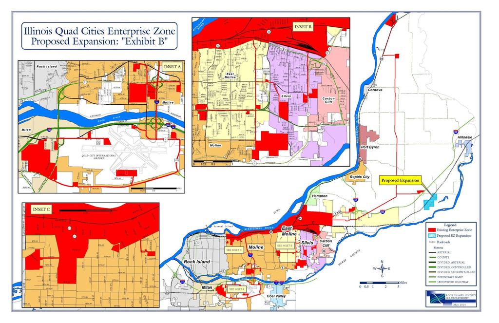
2 Title COMMITTEE OF THE WHOLE Enterprise Zone Amendment Date: May 5, 2014 Agenda Item 1 Presented By: O Donnell City Administrator Description: Rock Island County is seeking to expand the Quad City Enterprise Zone to facilitate and expansion of Tyson Foods. This would add approximately acres in Zuma Township. Any amendment must be approved by all member governments. A public hearing on the expansion is scheduled for May 5 th through Rock Island County FINANCIAL Is this a budgeted item? Yes No Line Item# Title: Amount Budgeted: Actual Cost: Under/(Over): Funding Sources: Departments: Is this item in the CIP? Yes No CIP Project Number:
3 COMMITTEE OF THE WHOLE Any previous Council actions: Action Date Recommendation: Give preliminary approval to the amendment. Required Action: ORDINANCE X RESOLUTION X NO ACTION REQUIRED Regular Meeting Date for Action Additional Comments: We will need to pass an ordinance on the amended zone and pass a resolution on an amended intergovernmental agreement. MOTION BY SECONDED BY TO CITY COUNCIL VOTES VOTES HELEN HEILAND GARY ALMBLADE JEFF STULIR ED DEJAYNES HUMBERTO AGUILAR ROBERT CHEFFER GARY WESTBROOK YES NO SENT ABSTAIN
4 AN ORDINANCE AMENDING ORDINANCE NO AS AMENDED BY ORDINANCE 98-41, RELATING TO THE ESTABLISHMENT OF AN ENTERPRISE ZONE IN THE CITY OF EAST MOLINE, ILLINOIS, PURSUANT TO AN INTERGOVERNMENTAL AGREEMENT WITH THE CITIES OF EAST MOLINE, ILLINOIS, MOLINE, ILLINOIS, SILVIS, ILLINOIS, VILLAGE OF MILAN, ILLINOIS, AND ROCK ISLAND COUNTY, ILLINOIS, BY THE ADDITION OF APPROXIMATELY ACRES BY THE COUNTY OF ROCK ISLAND AND BY REVISING SECTION 3, EXHIBITS "A" AND "B" TO INCLUDE NEW TERRITORY WITHIN THE ILLINOIS QUAD CITIES ENTERPRISE ZONE. WHEREAS, the Cities of East Moline, Moline, Silvis, Rock Island County and the Village of Milan, Illinois, comprise the Illinois Quad Cities Enterprise Zone; and WHEREAS, the County of Rock Island is requesting a change of the Illinois Quad City Enterprise Zone Boundaries by the addition of certain territory as described on Exhibit "A" attached hereto; and WHEREAS, pursuant to Illinois Revised Statute 1985, Ch. 67 1/2, the County of Rock Island, conducted a public hearing on Monday, May 5 th, 2014, and WHEREAS, addition of this territory will facilitate the increased economic benefit of the Quad Cities. NOW, THEREFORE, BE IT ORDAINED BY THE CITY COUNCIL OF THE CITY OF EAST MOLINE, ILLINOIS, as follows: Section 1. That Section 3, Exhibit "A" to Ordinance No , which provides a legal description of the area to be added to the Enterprise Zone, and Exhibit "B" thereof, which provides a map of the expanded Enterprise Zone, which exhibits are attached to this Ordinance and made a part hereof, shall be and are hereby amended as shown on said exhibits, to include additional territory within the Illinois Quad Cities Enterprise Zone, as described on Exhibit "1" attached hereto and incorporated herein. Section 2. That the City of East Moline hereby declares and affirms that the amended zone area as described on Exhibit "A", qualifies for expansion in accordance with the provision of the Illinois Enterprise Zone Act, and further affirms that: A. The additional territory is contiguous to the Illinois Quad Cities Enterprise Zone. B. The additional territory results in a zone which is not more than fifteen square miles;
5 C. The additional territory provides immediate substantial benefit to the established zone and/or its residents or businesses by creating jobs, removing an existing impediment to economic development and stimulating neighborhood residential and business revitalization; D. On the 5th day of May, 2014, a public hearing was conducted in the County of Rock Island Office Building in the County Board Committee Room on the question of whether to expand the territory of the established zone, adding the approximate acres, what the new boundaries are as proposed, and a finding made that the public notice was given in at least one newspaper of general circulation within the zone area, not more than 20 days nor less than 5 days before the hearing; E. The zone meets the qualifications of Section 4 of the Illinois Enterprise Zone Act. Section 3. That in all other respects, Ordinance No shall continue in full force and effect, shall not be repealed or superseded, and shall only be amended as set forth herein. Section 4. That this Ordinance shall be in full force and effect from and after its passage, approval, and, if required by law, publication in the manner provided by law. PASSED BY THE CITY COUNCIL OF THE CITY OF EAST MOLINE, ILLINOIS, this day of, A. D. 2014, and APPROVED BY THE MAYOR OF SAID CITY this day of, A. D Mayor of the City of East Moline, Illinois ATTEST: City Clerk of the City of East Moline, Illinois
6 A RESOLUTION AMENDING AN INTERGOVERNMENTAL AGREEMENT AMONG THE CITIES OF EAST MOLINE, MOLINE, SILVIS, THE VILLAGE OF MILAN, AND ROCK ISLAND COUNTY, ILLINOIS, WHICH ESTABLISHED AN ENTERPRISE ZONE NOW CALLED THE "ILLINOIS QUAD CITIES ENTERPRISE ZONE" BY THE ADDITION OF APPROXIMATELY ACRES AND CHANGING THE ZONE BOUNDARIES TO ADD TERRITORY TO THE ILLINOIS QUAD CITIES ENTERPRISE ZONE, AND BY AUTHORIZING THE MAYOR AND CITY CLERK TO EXECUTE THE AMENDED INTERGOVERNMENTAL AGREEMENT. WHEREAS, the Cities of East Moline, Moline, Silvis, the Village of Milan and Rock Island County, Illinois, currently comprise the Illinois Quad Cities Enterprise Zone; and WHEREAS, the County of Rock Island is requesting a change of the Illinois Quad City Enterprise Zone Boundaries by the addition of certain territory as described on the attached Exhibit "A"; and WHEREAS, pursuant to Illinois Revised Statute 1985, Ch. 67 1/2, the County of Rock Island conducted a public hearing on Monday, May 5th, 2014, and WHEREAS, addition of this territory to the enterprise zone will facilitate the increased economic benefit of the Quad Cities. NOW, THEREFORE, BE IT RESOLVED BY THE CITY COUNCIL OF THE CITY OF EAST MOLINE, ILLINOIS, as follows: That the City of East Moline hereby declares and affirms that the zone area qualifies for expansion in accordance with the provision of the Illinois Enterprise Zone Act, and further affirms that: A. The additional territory is contiguous to the zone area in the Illinois Quad Cities Enterprise Zone; B. The additional territory results in a zone which is not more than 15 square miles; C. The additional territory provides immediate substantial benefit to the established zone and/or its residents or businesses by creating jobs, removing an impediment to economic development which exists and stimulating neighborhood residential and business revitalization; BE IT FURTHER RESOLVED that the attached Exhibit "A", which provides a legal description of the area of the Enterprise Zone and Exhibit "B", which is a map of the Enterprise Zone, as attached to this
7 Resolution and made a part hereof, be amended to include additional territory within the County of Rock Island. BE IT FURTHER RESOLVED that the Mayor and City Clerk are hereby authorized to execute an amended Intergovernmental Agreement among the Cities of Moline, East Moline and Silvis Rock Island County and the Village of Milan related to adding certain territory located within the County of Rock Island to the Illinois Quad Cities Enterprise Zone; provided said Agreement is substantially similar in form and content to that attached hereto and incorporated herein by this reference thereto as Exhibit "1", and has been approved as to form by the City Attorney. Adopted this day of, A.D., Approved this day of, A.D., ATTEST: City Clerk of the City of East Moline, Illinois Mayor of the City of East Moline, Illinois
8 5/28/2008 Addition # Project Maximum Square Miles Quad City Enterprise Zone Zone Square Miles Square Miles DCEO Approval Lead Community Moline/East Moline/Silvis (7.000) 03/28/88 Zone expires 3/28/ One Moline Place (0.044) 01/07/99 Moline Add Rock Island County /28/99 2 Cordova Energy Co. LLC (0.083) 09/28/99 Rock Island County (1/12) 3 Deere Tech Center (0.480) 04/14/00 Rock Island County 4 3M Cordova/Emerald Point (0.500) 07/26/00 Rock Island County/East Moline 5 Fed Ex (0.025) 12/12/00 Moline Add Village of Milan /20/01 Deere Parts Distribution Ctr./Mississippi Laser Expan./Elliot Aviation/Stern Beverage (0.4700) 03/20/01 Village of Milan 6 Moline Welding (0.0060) 02/02/02 Rock Island County 7 Shopko (0.0192) 09/12/02 Moline 8 Southpark Mall (0.1757) 09/12/02 Moline 9 Kennedy Square (0.0970) 10/15/02 East Moline 10 Sinterco, Inc (0.0445) 02/05/03 Moline 11 East Moline Animal Clinic (0.0040) 09/01/03 East Moline 12 Jewel/Miller property (0.0701) 09/01/03 Silvis 13 Strategic Enterprises, Inc. (0.0103) 11/07/03 Milan 14 Former Eagles Food Store ( ) 10/04/04 East Moline Sammy G's ( ) 10/04/04 East Moline RV Parts & Service ( ) 10/04/04 East Moline Hospital Road ( ) 10/04/04 Silvis 15 Theater ( ) 6/1/2005 Moline 16 Loft Apts. ( ) 03/25/05 Moline 17 Avis Rental ( ) 03/25/05 Rock Island County 18 Autumn Trails ( ) 09/12/05 Moline 19 Hynd Farm ( ) 12/16/05 Silvis 20 FS / Black Hawk State Bank ( ) 01/19/06 Silvis 21 MATCON PULLED Rock Island County 23 Joslin Travel Plaza ( ) 05/26/06 Rock Island County 24 Beltway Commons ( ) Milan 25 Deere & Co Airport Hangar ( ) 05/28/08 Rock Island County 26 Trimble Pointe ( ) Moline 27 Holiday Inn Express ( ) Moline 28 Tyson ( acres) ( ) Rock Island County Total Square Miles REMAINING
9
10
11
12
13 Exhibit A DESCRIPTION OF ENTERPRISE ZONE Those parts of the City of East Moline, the City of Moline, and the City of Silvis, Illinois described as follows: That part of the City of Moline lying north of the following described line: beginning at the intersection of the west Moline City limit with 1 st Avenue; thence easterly in 1 st Avenue to 1 st Street; thence southerly in 1 st Street to 5 th Avenue; thence easterly in 5 th Avenue to 4 th Street, thence southerly in 4 th Street to 15 th Avenue, thence easterly in 15 th Avenue to 7 th Street; thence northerly in 7 th Street to 11th Avenue; thence easterly in 11 th Avenue to 8 th Street; thence northerly in 8 th Street to 5 th Avenue; 5 th Avenue Place, and 6 th Avenue to 12 th Street; thence southerly in 12 th Street to 7 th Avenue; thence easterly in 7 th Avenue to 26 th Street; thence northerly in 26 th Street to 6 th Avenue; thence easterly in 6 th Avenue, 5 th Avenue Place, and 5 th Avenue to 55 th Street; thence northerly in 55 th Street to its intersection with 4 th Avenue (17 th Avenue, East Moline); Also, those parts of the City of East Moline, Illinois and the City of Silvis, Illinois, lying north of the following described line: beginning at the intersection of 1st Street and 17 th Avenue; thence easterly along 17 th Avenue to 3 rd Street; thence southerly in 3 rd Street to 18 th Avenue; thence easterly in 18 th Avenue and 18 th Avenue extended to 19 th Street; thence northerly in 19 th Street to the southern line of the Heartland Railroad property; thence easterly along said southern line to Illinois Route 5; thence northeasterly along said Illinois Route 5 to N. 158 th Street; thence northerly in N. 158 th Street to the East Moline City limit line; thence easterly and northerly along said East Moline City limit to the east line of Section 28, T.18N, R-1-E of the 4 th P.M., and there terminating; excluding therefrom those parts of the City of East Moline lying north of the South ½ of Section 21, T,18N, R-1-E of the 4 th P.M. For the purposes of this description, the boundary described herein follows the centerline of the streets and alleys herein described, unless stated otherwise. Commencing at the Easterly line of the city limits of East Moline and the intersection of the MidAmerican Energy Company s (MEC) 69kV electric transmission line utility easement in the NE 1/4 of Sec. 28, T. 18N, R-1-E; Thence continuing in an Easterly direction including the Southerly three (3) feet of said easement, following said easement to the W line of MEC s electric substation site in Sec. 26, T. 18N, R-1-E; Thence continuing an Easterly direction through the substation site a width of three (3) feet to the intersection of said site with MEC s 345kV electric transmission line; Thence Easterly including the Southerly three (3) feet of said easement to a point E of I-80 in the SE 1/4 of Sec. 23, T. 18N, R-1E; Thence Northeasterly including the Southeasterly three (3) feet of said easement to a point in the NE 1/4 of Sec. 16, T. 18N, R-2-E; Thence Northerly including the Easterly three (3) feet of said easement to the intersection of said easement with the S line of the SW 1/4 of Sec. 33 T. 20N, R-2-E; Thence continuing Northerly including the Easterly three (3) feet of tax parcels numbered 213-1, (Sec. 33), (Sec. 28), (SW ½ Sec. 21) and the Easterly three (3) feet of that portion of Tax Parcel in the S ½ of the NW 1/4 of Sec. 21; thence including all of tax parcels 126, 126-2, and 125 in the N ½ of the NW 1/4 of said Sec. 21; Thence the Southerly five hundred eighteen (518) feet of the SE 1/4 of the SW 1/4, Sec 16, all located in T. 20N, R-2-E, Cordova Township, Rock Island County, Illinois. Commencing at the intersection of 13 th Street East Moline and 17th Avenue heading in a Southeasterly direction to a point where 13 th Street turns in a Southerly direction and following 13 th Street until it intersects with the East 467' of the SE 1/4 of the SE 1/4 of Sec. 12, T. 17N, R-1-W, also including the following portions of Sec. 7, T-17N, R-1-E, the N ½ of the SE 1/4, the S 1000' of the S ½ of the NE 1/4, the N 750' of the NW 1/4 of the SE 1/4; the N ½ of the SW 1/4; and the W 500' of the SW 1/2; and the SW 1/4 of the NW 1/4. For the purposes of this description the path described in 13 th Street E M consist of three feet (3) down the centerline of the public street. Commencing at the intersection of 192 nd Avenue N. and parcel 125 in the N ½ of the NW 1/4 of Section 21, T. 20 N, R-2-E in Cordova Township Rock Island County, Illinois. Heading westerly along 192 nd Avenue N. to the intersection with Illinois Route 84, heading in a northeasterly direction along Illinois Route 84 to the point where Illinois Route 84 intersects with Parcel 16 in T. 20 N, R- 2-E of the 4 th PM. Only that portion of parcel 16 lying north of Illinois Route 84 along with parcels 27-2, 26, 23-1, 242-3, 240 all lying within T. 20 N, R-2-E of the 4 th PM. For the purposes of this description, the path described along 192 nd Avenue N. and Illinois Route 84 consists of three (3) feet down the centerline of the public street. Additionally, commencing at the intersection of Illinois Route 5 and the East Moline City limits heading in a north easterly direction to a point where Illinois Route 5 heads easterly, following Illinois Route 5 to a point where Illinois Route 5 intersects the NW 1/4 Section line, T. 18 N, R-1-E, Section 23, then heading northerly to the intersection of said 1/4 section line and parcel number 520-5
14 Hampton Township, also including parcels 520, 520-4, 520-2, 519, all within Hampton Township. For the purposes of this description, the path along Illinois Route 5 consists of three (3) down the centerline of the public street. Commencing at the centerline of 7 th Avenue and intersection of FAI-74 and 7 th Avenue in Moline and heading southerly along FAI-74 to the intersection of US Route 6; and thence easterly down the centerline of US Route 6 to a point due south of the intersection of the westerly boundary of Parcel CV 12-1 lying in the northwest quarter of Section 22, T. 17 N, R-1-W, 4 th PM; thence north along a singular line to the south west corner of said parcel CV-12-1; thence northerly a distance of eight hundred (800) feet; thence easterly a distance of six hundred and sixty-six (666) feet; thence southerly a distance of eight hundred (800) feet; thence southerly to the centerline of US route 6; thence westerly two hundred fifteen (215) feet; thence southerly a distance of ten (10) feet; thence westerly a distance of three hundred and eighty-five (385) feet with the exception of parcel CV For the purposes of this description, the path described along FAI-74 and US Route 6 consist of three (3) feet down the centerline of the public highways. (FedEx Ground Expansion 11/2000) Additionally, commencing at the centerline of US Route 6 and the easterly boundary of Parcel CV 12-1, lying in the northwest quarter of Section 22, T. 17 N, R-1-W, 4 th PM; heading easterly in US Route 6 to US Route 150; heading southerly in US Rt. 150 to the Indian Bluff Road; heading in a south westerly direction in Indian Bluff Road to 68 th Street; heading northerly in 68 th Street to a parcel of land described as follows: Parcel 1) The westerly 1645 feet of the southerly feet of the South ½ of Section 21, T.17 N, R-1- W of the 4 th PM; Parcel 2) the Westerly 1645 feet of the northerly feet of the North ½ of Section 28, T.17 N, R-1-W of the 4 th PM; Parcel 3) The easterly 800 feet of the Southern feet of the Southeast 1/4 of Section 20, T. 17 N, R-1-W of the 4 th PM; and Parcel 4) The easterly 800 feet of the Northerly feet of the Northeast 1/4 of Section 29, T. 17 N, R-1-W of the 4 th PM; Additionally commencing again at the intersection of 68 th Street and Indian Bluff Road heading westerly to a point on the easterly edge of Tax parcel 52-1 in Section 30, T.17 N, R-1W of the 4 th PM.; commencing on the westerly edge of Tax parcel 52-1 and the intersection of Indian Bluff Road heading westerly in Indian Bluff Road to the easterly edge of Tax Parcel 57-2, inclusive of 57-F, 57, 21 and 18 in Section 30 T. 17N, R-1-W of the 4 th PM and Section 19, T.17 N, R-1-W of the 4 th PM and Tax Parcel 290-2, NE 1/4 Section 24, T.17 N, R-2-W of the 4th PM and; Tax Parcel 294 in SE 1/4 Section 24, T.17 N, R-2-W of the 4th PM. For the purposes of this description, the path described along US Route 6, US Route 150, Indian Bluff Road and 68 th Street consist of three (3) feet down the centerline of the public highways. (Elliot Aviation/Deere Airport/Milan 2/2001). Part of Outlots 2 and 3 of Valley View Place, an addition situated in the Southeast Quarter of the Southwest Quarter of Section 16 and the Northeast Quarter of the Northwest Quarter of Section21 all in Township 17 North, Range 1 West of the Fourth Principal Meridian being more particularly described as follows: Commencing at the Northwest corner of the said Outlot 2, Thence 00 degrees 33 minutes 51 seconds West along the West line of said Outlot 2, a distance of feet to a Point on the South Right-of-Way Line of 69 th Avenue (F. A. Route 10/F.A.U. Route 5788); Thence South 73 degrees 22 minutes 14 seconds East along the said South Right-of-Way Line, a distance of feet to the Point of Beginning; Thence continuing South 73 degrees 22 minutes 14 seconds East along the said South Right-of-Way Line, a distance of feet; Thence South 56 degrees 53 minutes 02 seconds East along the said South Right-of-Way Line, a distance of feet; Thence South 41 degrees 10 minutes 02 seconds West, a distance of feet; Thence North 66 degrees 41 minutes 12 seconds West, a distance of feet; Thence North 89 degrees 42 minutes 30 seconds West, a distance of feet; Thence North 00 degrees 37 minutes 50 seconds East, a distance of feet to the Point of Beginning, containing acres more or less. Basis of Bearings are to the West Line of said Outlot 2 South 00 degrees 33 minutes 51 seconds West to the Illinois State Plane Coordinate System, West Zone (NAD 83 ). Tax Parcel 57-A and including all of said parcel, Section 30, T.17 N, R-1-W of the 4 th PM, commencing on the westerly intersection of Tax Parcel 57-A in Indian Bluff Road (Moline Welding Feb 2002) Additionally, commencing at the centerline of I-74, turning in a Westerly direction and following John Deere Expressway (Highway 5) to a point where 27 th Street intersects, heading Northerly to 36 th Avenue and turning Westerly onto the Easterly side of Parcel 8046, Midvale 1 st Addition located in the S ½ of Sec. 9, T.17 N., R.I.W in South Moline Township. (Moline 6/2002) Commencing at the centerline of John Deere Expressway (Highway 5) and turning Southerly at the Northwest corner of Section 16, go North East, along the North line of Section 16 for feet; thence South East for 1, feet; thence North East for 50.0 feet to a point on the East line of 16 th Street and the Point of Beginning; thence North West for feet; thence North East for feet to the Southerly right-of-way line of State Route Number 5, also known as
15 John Deere Expressway; thence, along said Southerly right-of-way line, go North East for feet; thence South East for feet; thence South East for feet; thence along a curve to the left, the chord of which bears South East for feet, for an arc distance of feet; thence North East for feet to the West line of 27 th Street; thence along said West line, go South East for feet; thence South East for 1, feet; thence South East for 7.89 feet; thence South West for feet; thence South West feet; thence South West for feet; thence North West for feet, thence South West for feet; thence South East for feet; thence South West for feet; thence North West for feet, thence South West for feet; thence South West for feet; thence South West for feet; thence South East for feet to the North line of Ekhco 5 th Addition, thence South West along said South line for feet to the East line of 16 th Street; thence along said East line, go North East for 1, feet to the Point of Beginning and there terminating. Commencing at a point of reference at the Northwest corner of said Section 16; thence North East feet along the North line of the said Northwest quarter (1/4) of Section 16 (for purposes of this description the said North line of the Northwest quarter (1/4) of Section 16 is assumed to bear North East); thence South East 1, feet; thence North East feet to a point on the East right-of-way line of 16 th Street; thence South West 1, feet along the said East right-of-way line of 16 th Street; thence North East 1, feet to the Point of Beginning of the parcel herein described; thence continuing North East feet; thence North West feet; thence South West feet; thence South East feet to the said Point of Beginning; and Part of the Northwest quarter (1/4) of Section 16, Township 17 North, Range 1 West of the Fourth Principal Meridian, Moline, Rock Island County, Illinois more particularly described as follows: Commencing at a point of reference at the Northwest corner of said Section 16; thence North East feet along the North line of the said Northwest quarter (1/4) of Section 16 (for purposes of this description the said North line of the Northwest quarter (1/4) of Section 16 is assumed to bear North East); thence South East 1, feet; thence North East feet to a point on the East right-of-way line of 16 th Street; thence South West 1, feet along the said East right-of-way line of 16 th Street; thence North East feet to the Point of Beginning of the parcel herein described, thence continuing North East feet; thence North West feet; thence South West feet; thence South East feet to the Point of Beginning and there terminating. (Moline 6/2002) Commencing at the centerline of John Deere Expressway (Highway 5) and turning Southerly at the Northwest corner of Section 16, go North East, along the North line of Section 16 for feet; thence South East for 1, feet; thence North East for 50.0 feet to a point on the East line of 16 th Street and the Point of Beginning; thence North West for feet; thence North East for feet to the Southerly right-of-way line of State Route Number 5, also known as John Deere Expressway; thence, along said Southerly right-of-way line, go North East for feet; thence South East for feet; thence South East for feet; thence along a curve to the left, the chord of which bears South East for feet, for an arc distance of feet; thence North East for feet to the West line of 27 th Street; thence along said West line, go South East for feet; thence South East for 1, feet; thence South East for 7.89 feet; thence South West for feet; thence South West feet; thence South West for feet; thence North West for feet, thence South West for feet; thence South East for feet; thence South West for feet; thence North West for feet, thence South West for feet; thence South West for feet; thence South West for feet; thence South East for feet to the North line of Ekhco 5 th Addition, thence South West along said South line for feet to the East line of 16 th Street; thence along said East line, go North East for 1, feet to the Point of Beginning and there terminating. Commencing at a point of reference at the Northwest corner of said Section 16; thence North East feet along the North line of the said Northwest quarter (1/4) of Section 16 (for purposes of this description the said North line of the Northwest quarter (1/4) of Section 16 is assumed to bear North East); thence South East 1, feet; thence North East feet to a point on the East right-of-way line of 16 th Street; thence South West 1, feet along the said East right-of-way line of 16 th Street; thence North East 1, feet to the Point of Beginning of the parcel herein described; thence continuing North East feet; thence North West feet; thence South West feet; thence South East feet to the said Point of Beginning; and Part of the Northwest quarter (1/4) of Section 16, Township 17 North, Range 1 West of the Fourth Principal Meridian, Moline, Rock Island County, Illinois more particularly described as follows: Commencing at a point of reference at the Northwest corner of said Section 16; thence North East feet along the North line of the said Northwest quarter (1/4) of Section 16 (for purposes of this description the said North line of the Northwest quarter (1/4) of Section 16 is assumed to bear North East); thence South East 1, feet; thence North East feet to a point on the East right-of-way line of 16 th Street; thence South West 1, feet along the said
16 East right-of-way line of 16 th Street; thence North East feet to the Point of Beginning of the parcel herein described, thence continuing North East feet; thence North West feet; thence South West feet; thence South East feet to the Point of Beginning and there terminating. (Moline 6/2002) Additionally, commencing at the South Quarter Corner of said Section 2, thence North 90 degrees 00 minutes 00 seconds East, feet on the south line of said Section 2 to the southeast corner of Supervisor of Assessments tax parcel SM 56 and THE POINT OF BEGINNING; thence North 00 degrees 00 minutes 00 seconds East, feet on the east line of Supervisor of Assessments tax parcel SM 56, SM 44-1 and SM 43-1; thence North 90 degrees 00 minutes 00 seconds West, feet on the north line of Supervisor of Assessments tax parcel SM 43-1 to the west line of the Southeast Quarter of said Section 2; thence North 00 degrees 00 minutes 00 seconds East, feet on said line and the extension of said line to the northerly right of way line of 23 rd Avenue; thence North 88 degrees 50 minutes 04 seconds West, feet on said right of way line; thence South 87 degrees 37 minutes 36 seconds West, feet on said right of way line to the southeast corner of Supervisor of Assessments tax parcel SM 46; thence North 00 degrees 35 minutes 39 seconds West, feet on the west line of said tax parcel to the southerly right of way line of 22 nd Avenue; thence North 70 degrees 59 minutes 07 seconds East, feet on said right of way line to the beginning of a tangent curve, concave southerly with a radius of feet; thence easterly feet on the arc of said curve and right of way line; thence South 90 degrees 00 minutes 00 seconds East, feet on said right of way line to the westerly right of way line of Kennedy Drive; thence South 00 degrees 00 minutes 00 seconds West, feet on said right of way line; thence South 90 degrees 00 minutes 00 seconds West, feet on the easterly extension of the north line of Supervisor of Assessments tax parcel SM 57-2 and on said line to the west line of said tax parcel; thence South 00 degrees 00 minutes 00 seconds East, feet to the north line of Supervisor of Assessments tax parcel SM 57-5; thence South 90 degrees 00 minutes 00 seconds West, feet on said line to the west line of Supervisor of Assessments tax parcel SM 57-5; thence South 00 degrees 00 minutes 00 seconds East, feet on said line to the northerly right of way line of Colona Avenue (42 nd Avenue); thence North 83 degrees 42 minutes 00 seconds East, feet on said right of way line; thence North 26 degrees 11 minutes 56 seconds East, feet to the westerly right of way line of Kennedy Drive; thence South 00 degrees 00 minutes 00 seconds East, feet to a point 1.50 feet north of the centerline of 42 nd Avenue; thence south 90 degrees 00 minutes 00 seconds East, feet, parallel with and 1.50 feet distant from said centerline to the easterly right of way line of 13th Street; thence South 00 degrees 00 minutes 00 seconds East, 3.00 feet on said right of way line to a point 1.50 feet south of the centerline of 42 nd Avenue; thence North 90 degrees 00 minutes 00 seconds West, feet, parallel with and 1.50 feet distant from said centerline to the westerly right of way line of Kennedy Drive; thence South 00 degrees 00 minutes 00 seconds West, feet on said right of way line; thence South 09 degrees 55 minutes 39 seconds West, feet on said right of way line; thence South 05 degrees 52 minutes 15 seconds East, feet on said right of way line to the south line of Section 2; thence North 90 degrees 00 minutes 00 seconds West, feet on said south line to the point of beginning, containing acres, more or less. (East Moline Southwest & Northwest corner of Kennedy and 42 nd Avenue 8/2002) For the purposes of this description, the boundary described herein follows the centerline of the streets and alleys herein described, unless stated otherwise. Part of the Southwest Quarter of Section 31, Township 18 North, Range 1 East of the 4 th Principal Meridian, part of the Northwest Quarter of Section 6, Township 17 North, Range 1 East of the 4 th Principal Meridian, part of the Southeast Quarter of Section 36, Township 18 North, Range 1 West of the 4 th Principal Meridian and part of the Northeast Quarter of Section 1, Township 17 North, Range 1 West of the 4 th Principal Meridian, described as follows: Beginning at the point of intersection of a line 1.5 feet east of and parallel with 13 th Street and a point 1.5 feet north of the centerline of 30 th Avenue, thence East, 1355 feet parallel with and 1.5 feet distant northerly from said centerline to the southerly extension of the west line of Supervisor of Assessments Tax Parcel ; thence North feet on said west line to the northerly line of said Tax Parcel: thence South 74 degrees 43 minutes East, feet on said north line to the east line of said Tax Parcel; thence South feet on said east line and it s extension to a point 1.5 feet south of the centerline of 30 th Avenue; thence West, parallel with and 1.5 feet distant southerly from the centerline of 30 th Avenue to a point 1.5 feet west of the centerline of 13 th Street; thence North 1.5 feet to the point of beginning, containing 2.56 acres, more or less. And also that part of the Fractional Southwest Quarter being more particularly described as follows; Commencing at the Southeast Corner of Lot 6 according to the Assessor s Plat of 1863 in the Fractional Southwest Quarter South of the Flack and Bean Indian Boundary Line, of Section 31, Township 18 North, Range 1 East of the 4 th Principal Meridian; thence North on the East Line of said Lot 6, feet, for a place of beginning; thence South 86 degrees 24 minutes East, 325 feet to the West line of Highway Route 80; thence Southerly on the West line of said Route 80, 20 feet; thence North 86 degrees 24 minutes West, 324 feet to a point on East line of said Lot 6; thence Northerly on the Easterly line of said Lot 6, 20 feet to the point of beginning, containing acres more or less. (East Moline 6/2003 animal hospital) Commencing at the intersection of the of tax parcel H-611-RU and the northwest corner of a parcel of land owned by the City of Silvis as the location of Well Number 7 both as shown on sheet 69 of the Supervisor of Assessment Map of Hampton Township Supplemental for 1986; thence southwesterly along the west line of said parcel owned by the City of Silvis, including the westerly three feet of said parcel, 100 feet; thence southwest along the west line and the southern extension of the west line of tax parcel H-737 as shown on sheet 69 of the Supervisor of Assessment Map of Hampton Township Supplemental for 1986, including the westerly three feet of said parcel to its intersection with the south right-of-way of 1 st Avenue; thence southeast along said right-of-way,
17 including the southerly three feet of said right-of-way, to the intersection of said right-of-way and the west right-of-way of 17 th Street; thence southerly along the west right-of-way of 17 th Street, including the westerly three feet of said right-of-way, to the intersection of said right-of-way and the northeast corner of tax parcel H-8351 as shown on sheet 7 of the Supervisor of Assessment Map of Hampton Township Supplemental for 1986; thence N W along the north line of tax parcel H-8351, feet; thence N W along the east line of tax parcel H-8350 as shown on sheet 7 of the Supervisor of Assessment Map of Hampton Township Supplemental for 1986, feet; thence N W along the north line of H-8350, feet, thence N E along the east line of tax parcel H-8350, feet to the south right-of-way of 11 th Avenue; thence N W, feet along said rightof-way; thence S W along the west line of tax parcel H-8350, feet; thence N W along the north line of tax parcel H-8350, feet; thence S W along the west line of tax parcels H-8350 and H-8351, feet; thence S E along the west line of tax parcels H-8351 and H-8352 as shown on sheet 7 of the Supervisor of Assessment Map of Hampton Township Supplemental for 1986, feet; thence S E along the south line of tax parcel H-8352, feet to the west right-of-way of 17 th Street; thence N E along said right-of-way feet; thence N E along said right-ofway feet; thence N W along the north line of tax parcel H-8352, feet; thence N W along the north line of tax parcel H-8352, feet; thence feet along the north line of tax parcel H-8352 along an arc concave north with a radius of 50 feet and a chord bearing N W, feet; thence feet along the south line of tax parcel H-8351 along an arc concave south with a radius of 50 feet and a chord bearing N E, feet; thence S E along the south line of tax parcel H-8351, feet; thence N E along the south line of tax parcel H-8351, feet to the west right-of-way of 17 th Street; thence N E along said right-of-way feet; thence N W along said right-of-way feet; thence easterly across 17 th Street to the east right-of-way of 17 th Street; thence S W along said east right-of-way feet; thence S E along the south line of tax parcel H-44-1 as shown on sheet 8 of the Supervisor of Assessment Map of Hampton Township Supplemental for 1986, feet; thence S E along the south line of tax parcel H-44 as shown on sheet 8 of the Supervisor of Assessment Map of Hampton Township Supplemental for 1986, feet to the East line of the West Half of the Northeast Quarter of Section 5; thence N W along said line 1250 feet; thence N W along the north line of tax parcel H-44, feet to the east right-of-way of 17 th Street; thence S E along said right-of-way feet; thence S E along said right-of-way feet; thence S E along said right-of-way feet; thence S W along said right-of-way feet; thence S E along said right-of-way feet; thence S E along said right-of-way feet; thence S E along said right-of-way feet; thence S W along said right-of-way feet; thence S E along said right-of-way feet; thence S E along said right-of-way feet; thence S W along said right-of-way 297 feet; thence westerly across 17 th Street to the intersection of the west right-of-way of 17 th Street and the northeast corner of tax parcel H-8351, all located in Sections 5 and 32, Townships 17 North and 18 North, Range 1 East of the 4 th Principal Meridian in the City of Silvis, Rock Island County containing acres, more or less. The amended area includes all of Tax Parcels H-44, H-44-1, H-8350, H-8351, and H The bearings used for this description are from Document Numbers , , and as recorded in the Rock Island County Recorder s Office and from Illinois DOT Right-of-Way Plats for F.A. Route 595 dated July 12, (Silvis 6/2003 Jewel/Miller project) Part of the Southwest Quarter of Section 19 and part of the East 332 feet of the South Half of the East acres of the Northwest Quarter of Section 19, all in Township 17 North, Range 1 West of the Fourth Principal Meridian, County of Rock Island, State of Illinois, described as follows: Commencing at the Northeast Corner of said Southwest Quarter; thence North 89 degrees 31 minutes 49 seconds West along the North Line of said Southwest Quarter, a distance of feet to the Point of Beginning; thence North 89 degrees 31 minutes 49 seconds West along said North Line, a distance of feet; thence South 00 degrees 46 minutes 47 seconds West, a distance of feet; thence North 89 degrees 31 minutes 49 seconds West, a distance of feet to the West Right-of-Way Line of County Highway Route 78; thence North 00 degree 46 minutes 47 seconds East along said West Right-of-Way Line, a distance of 7.00 feet; thence North 89 degrees 31 minutes 49 seconds West, a distance of feet to the East Line of Deere and Company, a Delaware Corporation; thence North 01 degree 10 minutes 06 seconds East along said East Line of Deere and Company, a Delaware Corporation, a distance of 3.00 feet to the North Right-of-Way Line of Blackhawk Township; thence South 89 degrees 31 minutes 49 seconds East along said North Right-of-Way Line, a distance of feet to the West Right-of-Way Line of County Highway Route 78; thence North 00 degree 46 minutes 47 seconds East along said West Right-of-Way Line, a distance of feet to the North Line of said Southwest Quarter; thence North 89 degrees 31 minutes 49 seconds West along said North Line, a distance of feet to the Southeast Corner of Jensen s Subdivision; thence North 00 degrees 43 minutes 01 second East along the East Line of said Jensen s Subdivision, a distance of feet; thence South 89 degrees 28 minutes 33 seconds East, a distance of feet; thence South 09 degrees 28 minutes 33 seconds East, a distance of feet; thence South 11 degrees 22 minutes 57 seconds East, a distance of feet; thence South 00 degrees 26 minutes 37 seconds East, a distance of feet to the Point of Beginning. The above described tract of land contains acres, more or less. For the purpose of this description the North Line of said Southwest Quarter of Section 19, has been assigned the bearing of North 89 degrees 31 minutes 49 seconds West. (Milan 7/2003 Blackhawk Autoplex project)
18 Beginning at the southeast corner of Lot Two (2) in Maher s Garden Tracts, being located in part of the SW ¼ of Section 28, Township 18 North, Range 1 East of the 4 th Principal Meridian, City of East Moline, Rock Island County, Illinois; Thence westerly along the south line of said Lot Two (2), to the east right of way line of a public roadway 163 rd Street North; Thence northerly along said east line and an extension of said east line to a point on the East Moline city limit line; Thence easterly along said city limit line 645 feet, more or less; Thence southerly to the northeast corner of Lot One (1) of said Maher s Garden Tracts; Thence Southerly along the east line of said Lots One (1) and Two (2) to the Point of Beginning. (East Moline 8/2004 RV Parts and Service Center project) Part of the Southeast Quarter of Section 1, Township 17 North, Range 1 West of the 4 th Principal Meridian, described as follows: Commencing at the intersection of the northerly extension of the easterly right of way line of 11th Street and the southerly line of the existing enterprise boundary, 3 feet wide, centered in the Avenue of the Cities right of way, thence North 90 degrees 00 minutes 00 seconds East, feet, on said southerly line to the POINT OF BEGINNING; thence South 00 degrees 00 minutes 00 seconds East, feet; Thence North 90 degrees 00 minutes 00 seconds East, feet on the north line of Supervisor of Assessment Parcel to the east line of said Parcel; thence South 00 degrees 00 minutes 00 seconds East, feet on said line to the south line of said Parcel; thence North 90 degrees 00 minutes 00 seconds West, feet, on said south line to the west line of said Parcel and the east right of way line for 11 th Street; thence North 00 degrees 00 minutes 00 seconds East, feet on said line to the south line of Supervisor of Assessment Parcel ; thence North 89 degrees 24 minutes 27 seconds East, feet, on said south line to the east line of said Parcel; thence North 01 degrees 52 minutes 05 seconds West, seconds on said east line; thence North 00 degrees 00 minutes 00 seconds East, feet to the southerly line of the existing enterprise boundary, 3 feet wide; thence North 90 degrees 00 minutes 00 seconds East, feet, on said southerly line to the point of beginning, containing 3.50 acres, more or less. (East Moline 8/2004 Sammy G s project) Part of the northwest quarter of the southwest quarter of section 6, township 17 north, range 1 east of the 4th p.m., East Moline, Rock Island County, Illinois, described as follows: Beginning at the intersection of a point in the west line of the existing Enterprise Zone, 1.5 feet East of the centerline of 13 th Street (Archer Drive) Thence a line 3 feet wide north 90 degrees 00 minutes 00 seconds east, a distance of Feet connecting to the northwest corner of a tract of land being lots 1 and 2 of eagle subdivision, filed for record on November 14, 1996, as document no and lots 1 and 2 of eagles subdivision phase ii, filed for record on may 3, 2001, as document no in the office of the rock island county recorder, said point being the point of beginning; thence south 89 degrees 53 minutes 53 seconds east along the north line of said eagle subdivision, a distance of feet; Thence north 00 degrees 15 minutes 34 seconds east, a distance of 5.20 Feet; thence south 89 degrees 35 minutes 20 seconds east along said north line a distance of feet to the northeast corner of said eagle subdivision, said point also being the northwest corner of Hampton parcel h 88-3; thence south 00 degrees 15 minutes 34 seconds west along the east line of said eagle subdivision, a distance of feet to the southeast corner of said eagle subdivision, said point also being on the north right of way line of the avenue of the cities frontage road and on the arc of a 1, feet long radius circular curve, concave to the northeast, with a central angle of 03 degrees 53 minutes 04 seconds and an feet long chord that Bears south 86 degrees 28 minutes 54 seconds west; thence along the arc of said curve to the right, a distance of feet; thence south 00 degrees 15 minutes 34 seconds west a distance of 9.75 feet; thence north 82 degrees 24 minutes 41 seconds west, a distance of feet to a point on a feet long radius circular curve concave to the northeast, with a central angle of 13 degrees 01 minutes 15 seconds, and a feet long chord that bears north 70 degrees 02 minutes 36 seconds west; thence along the arc of said curve to the right, a distance of feet; thence north 63 degrees 32 minutes 23 seconds west, a distance of feet to the southwest corner of said eagle subdivision, said point also being a point on the easterly right of way line of 13th street; thence north 02 degrees 48 minutes 36 seconds west along the easterly right of way line of said 13th street, a distance of feet; thence north 00 degrees 00 minutes 00 seconds west along said easterly right of way line, a distance of 9.83 feet to the point of beginning. The above-described parcel contains acres more or less and is subject to all easements of record. (East Moline 8/2004 Former Eagle s site) For the purposes this description, the boundary described herein follows the centerline of the streets and alleys herein described, unless state otherwise. Parts of the Southwest Quarter of Section 31, Township 18 North, Range 1 East of the 4 th Principal Meridian, part of the Northwest Quarter of Section 6, Township 17 North, Range 1, East of the 4 th Principal Meridian, described as follows: Commencing at the Southeast Corner of Lot 6 according to the Assessor s Plat of 1863 in the Fractional Southwest Quarter South of the Flack and Bean Indian Boundary Line, of Section 31, Township 18 North, Range 1 East of the 4 th Principal Meridian; thence North on the East Line of said Lot 6, feet; thence South 86 degrees 24 minutes East, 325 feet to the West Line of Highway Route 80; thence Southerly on the West Line of said Route 80, 17 feet to the point of beginning; thence South 86 degrees 24 minutes East 41.3 feet, more or less to a point 1.5 feet distant easterly of the centerline of 19 th Street; thence southerly feet, more or less, parallel with and 1.5 feet distant easterly from said centerline to a point 1.5 feet northerly of the centerline of Crosstown Avenue; thence easterly feet, more or less, parallel with and 1.5 feet distant northerly from the centerline of Crosstown Avenue to a point 3 feet easterly of the extension of the westerly line of Supervisor of Assessments Tax Parcel H-68-1; thence southerly 64.0 feet, more or less, parallel with and 3 feet distant easterly to the extension of the westerly line of said parcel to a point on the north line of said parcel; thence southeasterly feet, more or less, on the north line of Parcel H-68-1 to the south line of said parcel; thence westerly
19 feet, more or less, on said south line to the west line of said parcel; thence northerly 142 feet, more or less, on said west line to the north line of said parcel; thence continuing northerly 60.6 feet, more or less, on the extension of the west line of said parcel to a point 1.5 feet southerly of the centerline of Crosstown Avenue; thence westerly feet, more or less, parallel with and 1.5 feet distant southerly from said centerline to a point 1.5 feet distant westerly of the centerline of 19 th Street; thence northerly feet, more or less, parallel with and 1.5 feet distant westerly of the centerline of 19 th Street; thence North 86 degrees 24 minutes West 38.3 feet, more or less to the West Line of Highway Route 80; thence Northerly on the West Line of Highway Route 80, 3 feet, more or less, to the point of beginning, containing acres more or less. (Silvis 8/2004 Hospital Road site) Part of the South Half of Section 9, part of the Southwest Quarter of Section 10 and part of the Northwest Quarter of Section 15, all in township 17 North, Range 1 West of the 4 th Principal Meridian, described as follows: Beginning at the intersection of a point in the east line of the existing Enterprise Zone, 1.5 feet east of the centerline of I-74 and 3 feet north of the south line of the South Half of said Section 9, thence East, parallel with and 3 feet distant north from the south line of the South Half of said Section 9 and 3 feet distant north from the south line of the Southwest Quarter of said Section 10, to a point 1.5 feet east of the centerline of 38 th Street; thence South 00 degrees 14 minutes 30 seconds East, feet, parallel with and 1.5 feet distant from said centerline, to the northerly right of way line of 42 nd Avenue; thence North 89 degrees 40 minutes 31 seconds West, feet; thence North 00 degrees 12 minutes 06 seconds East, feet; thence North 63 degrees 15 minutes 24 seconds East, feet to the southerly right of way line of 40 th Avenue; thence North 84 degrees 54 minutes 24 seconds East, feet on said right of way line; thence South 29 degrees 27 minutes 28 seconds East, feet to the westerly right of way line of 38 th Street; thence South 05 degrees 01 minutes 46 seconds East, feet on said right of way line; thence South 00 degrees 14 minutes 30 seconds West, feet on said right of way line to a point 3.00 feet north of the north right of way line of 42 nd Avenue; thence South 89 degrees 40 minutes 31 seconds East, feet to a point 1.5 feet westerly from the centerline of 38 th Street; thence North 00 degrees 14 minutes 30 seconds East, feet, parallel with and 1.5 feet distant from said centerline, to the south line of the Southwest Quarter of Section 10; thence West on the south line of said Section 10 and on the south line of Section 9 to a point in the east line of the existing Enterprise Zone, 1.5 feet east of the centerline of I-74 and there terminating, containing 7.16 acres, more or less. (Moline 8/2004 Theater project) BEGINNING AT THE POINT WHERE THE WEST LINE OF LOTS 3, 4, 5 AND 6 OF MICHAEL HARTZELL S ADDITION FILED JULY 26, 1878 IN DEED BOOK 66, PAGE 231, IN THE CITY OF MOLINE, ILLINOIS, EXTENDED NORTHERLY INTERSECTS THE CENTERLINE OF 7 th AVENUE AS NOW ESTABLISHED IN THE CITY OF MOLINE, ILLINOIS; THENCE SOUTH ALONG SAID WEST LINE AND SAID WEST LINE EXTENDED, FEET, MORE OR LESS, TO THE SOUTHWEST CORNER OF LOT 6 IN SAID MICHAEL HARTZELL S ADDITION; THENCE SOUTH 02º 30 EAST, MORE OR LESS, ALONG THE WEST LINE OF LOTS 7, 8, 9, 10, 11 AND 12 IN SAID MICHAEL HARTZELL S ADDITION, A DISTANCE OF FEET, MORE OR LESS TO THE SOUTHWEST CORNER OF LOT 12 IN SAID MICHAEL HARTZELL S ADDITION, SAID POINT ALSO BEING ON THE NORTH RIGHT OF WAY LINE OF 10 TH AVENUE IN THE CITY OF MOLINE, ILLINOIS, AS NOW ESTABLISHED; THENCE SOUTH 90º 00 EAST, MORE OR LESS, ALONG SAID NORTH RIGHT OF WAY LINE, SAID LINE ALSO BEING THE SOUTH LINE OF LOTS 12 AND 13 IN MICHAEL HARTZELL S ADDITION AND THE SOUTH LINE OF LOTS 10 AND 11 IN GEORGE W. BELL S ADDITION FILED MARCH 24, 1902, IN PLAT BOOK 7, PAGE 58, IN THE CITY OF MOLINE, ILLINOIS, A DISTANCE OF FEET, MORE OR LESS, TO THE NORTHWEST CORNER OF TAX PARCEL NO , LOCALLY KNOWN AS TH STREET IN THE CITY OF MOLINE, ILLINOIS, AND THERE TERMINATING, containing 2.2 acres more or less. (Moline 11/2004 Moline HS Loft project) Part of the Northwest and Northeast Quarters of Section 19 and the Northwest Quarter of Section 20, Township 17 North, Range 1 West of the 4 th Principal Meridian, Blackhawk Township, Rock Island County, Illinois, more particularly described as follows: Commencing at the Southeast Corner of the Northwest Quarter of Section 19; thence North 89 degrees 31 minutes 49 seconds West along the South Line of said Northwest Quarter, a distance of feet to the Point of Beginning of a 3 foot wide tract of land (which centerline is) as follows: From the point of beginning South 89 degrees 31 minutes 49 seconds East along the South Line of said Northwest Quarter, a distance of feet to the Southeast Corner of said Northwest Quarter; Thence North along the East Line of said Northwest Quarter to the Northeast Corner of the Southeast Quarter of said Northwest Quarter of Section 19; Thence East to the Southeast Corner of the Northwest Quarter of the Northwest Quarter of Section 20; Thence North 00 degrees 21 minutes 35 seconds East, a distance of feet to the North Right of Way Line of State Aid Route 32 (also known as 69 th Avenue) and the end of the 3 foot wide tract. Beginning at a point where the 3 foot wide tract ends North 89 degrees 28 minutes 14 seconds West along said North Right of Way Line, a distance of feet; Thence North 00 degrees 44 minutes 23 seconds East, a distance of feet to the Southerly Right of Way Line of Federal Aid Route 138; Thence curving to the right a distance of feet along the arc of a circle having a radius of feet, and having a chord bearing of North 61 degrees 34 minutes 13 seconds East and a chord distance of feet to the West Line of Lot 1, Twilight Gardens Addition; Thence South 00 degrees 01 minutes 34 seconds West along said West Line, a distance of feet to the Northwest Corner of Lot 10 Home Addition; Thence South 00 degrees 21 minutes 35 seconds West along the West Line of said Lot 10, a distance of feet to the North Right of Way Line of State Aid Route 32 and the point of beginning. For the purpose of this description, the North Right of Way Line of State Aid Route 32 is assumed to have a bearing of North 89 degrees 28 minutes 14 seconds West. The above-described 3 foot wide tract of land contains 0.37 acres and the parcel contains acres to total 6.34 acres, more or less. (RI County 1/2005 Avis-Budget)
20 Part of Lot 1 of Heirs of C.F. Mueller s Assessors Plat of the West 50 Acres of the North Half of the Northeast Quarter of Section 6, Township 17 North, Range 1 West of the 4 th Principal Meridian, which lays West of Third Street in the city of Moline. Also, part of the West Half of the Southeast Quarter of Section 31, Township 18 North, Range 1 West of the 4 th Principal Meridian, in the City of Moline, County of Rock Island, State of Illinois, more particularly described of follows: Beginning at the Southwest Corner of the Southeast Quarter of said Section 31; Thence North 01 degrees 03 minutes 49 seconds West, along the West Line of said Southeast Quarter, a distance of feet, to the Southeast Line of Tract 2 an exception to Parcel 3, as described in Warranty Deed-document number in the Rock Island County Recorders office; Thence North 60 degrees 39 minutes 04 seconds East, along said Southeast Line, a distance of feet; Thence North 52 degrees 53 minutes 59 seconds East, along said Southeast Line, a distance of feet, to the East line of said exception to Parcel 3; Thence North 01 degrees 08 minutes 51 seconds West, along said East line, a distance of feet, to the North line of said Parcel 3; Thence North 88 degrees 52 minutes 38 seconds East, along said North Line, a distance of feet, to the West Line of Block 1 in Brooks 1 st Addition to the City of Moline; Thence South 00 degrees 15 minutes 20 seconds East, along said West line, a distance of feet, to the North Right-of- Way line of 11 th Avenue. Thence South 62 degrees 40 minutes 07 seconds East, along said North line, a distance of feet; Thence East, along said North line, a distance of 935 feet more or less, to the centerline of 4 th Street; Thence South, along said Center line, a distance of 60 feet more or less, to the South Right-of-Way line of 11 th Avenue; Thence West, along said South line, a distance of 795 feet more or less, to the West Right-of-Way line of 3 rd Street; Thence South 00 degrees 28 minutes 50 seconds East, along said West line, a distance of feet, to the North Line of Block 2 in Brooks 1 st Addition to the City of Moline; Thence South 89 degrees 34 minutes 15 seconds West, along said North line, a distance of feet, to the West Line of said Block 2; Thence South 00 degrees 15 minutes 20 seconds East, along said West line, a distance of 300 feet more or less, to the North Right-of-Way line of 12 th Avenue; Thence North 89 degrees 55 minutes 45 seconds East, along said North line, a distance of feet, to the West Right-of- Way of 3 rd Street; Thence South 00 degrees 29 minutes 30 seconds East, along said West Right-of-Way Line, a distance of feet, to the North line of the property described in Warranty Deed-document number in the Rock Island County Recorders office; Thence North 89 degrees 46 minutes 54 seconds West, along said North line and it s Westerly extension, a distance of feet, to the West Line of the exception to Parcel 1 as described in Warranty Deed-document number in the Rock Island County Recorders office; Lot 1; Thence South 00 degrees 11 minutes 11 seconds East, along said West line, a distance of feet, to the South Line of said Thence South 89 degrees 57 minutes 48 seconds West, along said South line, a distance of feet, to the West Line of the Northeast Quarter of said Section 6; Thence North 01 degrees 42 minutes 30 seconds East, along said West line, a distance of feet, to the Point of Beginning; For the purpose of this description, the West Line of Southeast Quarter of said Section 31, has a bearing of North 01 degrees 03 minutes 49 seconds West, based on the North American Datum of 1983, Illinois State Plane Coordinate System, West Zone.
21 (Moline 6/2005 Autumn Trails) Part of Section 6, Township 17 North, Range 1 East of the 4 th Principal Meridian, described as follows: Beginning at the southwest corner of Supervisor of Assessments Parcel , thence South 53 degrees 32 minutes 58 seconds West, feet to a point on Hospital Road; thence South 36 degrees 27 minutes 02 seconds East, feet in said Road; thence South 01 degrees 09 minutes 58 seconds West, feet in said Road to the westerly extension of the north right of way line of Illini Drive; thence North 89 degrees 53 minutes 26 seconds East, feet on said right of way line to the east right of way line of 10 th Street; thence South 00 degrees 32 minutes 10 seconds East, feet on said right of way line to the southerly right of way line of Colona Road; thence North 63 degrees 56 minutes 56 seconds West, feet on said right of way line to the southerly extension of Supervisor of Assessments Parcel ; thence North 00 degrees 18 minutes 27 seconds East, feet on said line; thence North 89 degrees 41 minutes 33 seconds West, feet to the westerly right of way line of Hospital Road; thence North 04 degrees 52 minutes 14 seconds East, feet on said right of way line; thence North 00 degrees 27 minutes 47 seconds East, feet on said right of way line; thence North 89 degrees 54 minutes 25 seconds East, feet to a point in Hospital Road; thence North 01 degrees 09 minutes 58 seconds East, feet to a point in Hospital Road; thence North 36 degrees 27 minutes 02 seconds West, feet to a point in Hospital Road; thence North 53 degrees 32 minutes 58 seconds East, feet to the westerly boundary of Supervisor of Assessments Parcel (Silvis - Hynd Farm Sept. 2005) Also, all that part of the Northeast Quarter and the Northwest Quarter of Section 32, Township 18 North, Range 1 East of the Fourth Principal Meridian, City of Silvis, Rock Island County, Illinois, described as follows: Beginning at an intersection of the north line of First Avenue, City of Silvis, with the west line of Sixteenth Street, City of Silvis, extended; thence South 79 degree 22 East along the north line of First Avenue a distance of feet; thence North 10 degree 38 East a distance of feet to the centerline of the existing railroad spur; thence in a southwesterly direction along a 8 degree 00 curve, and along the centerline of said railroad spur, a distance of feet; thence South 10 degree 38 West a distance of feet to the north line of First Avenue; thence South 79 degree 22 East along said north line a distance of 2.0 feet to the point of beginning, containing acres. (Silvis FS Territory December 2005) Part of the Northwest Quarter of Section 32, Township 18 North, Range 1 East of the 4 th Principal Meridian, described as follows: Beginning at the southwesterly corner of Supervisor of Assessments Tax Parcel ; thence South 74 degrees 53 minutes 28 seconds East, 3.00 feet; thence South 15 degrees 06 minutes 32 seconds West, feet; thence North 74 degrees 51 minutes 58 seconds West, feet; thence South 15 degrees 15 minutes 18 seconds West, feet to the northeast corner of Lot 7 in Block 11 of Town of Silvis as filed May 20, 1905 in Plat Book 9, page 28; thence South 14 degrees 42 minutes 58 seconds West, feet on the easterly line of said Lot to the northerly line of the public alley; thence North 74 degrees 48 minutes 57 seconds West, feet on said northerly line to the southwesterly corner of Lot 12 in Block 11 of Town of Silvis as filed May 20, 1905 in Plat Book 9, page 28; thence North 14 degrees 45 minutes 43 seconds East, feet on the westerly line of said Lot 12 to the southerly right of way line of 1 st Avenue; thence South 74 degrees 51 minutes 24 seconds East, feet on said southerly right of way line to a point 3.00 feet North 74 degrees 51 minutes 24 seconds West of the northeast corner of Lot 7 in Block 11 of Town of Silvis as filed May 20, 1905 in Plat Book 9, page 28; thence North 15 degrees 15 minutes 18 seconds East, feet; thence South 74 degrees 51 minutes 52 seconds East, feet; thence North 15 degrees 06 minutes 32 seconds East, feet to the point of beginning, containing 1.45 acres, more or less. (Silvis Black Hawk State Bank December 2005) Part of the Southeast Quarter of Section 10 and the Southwest Quarter of Section 11, Township 18 North, Range 2 East of the 4 th Principal Meridian, Zuma Township, Rock Island County, Illinois, more particularly described as follows: A 3 foot wide tract with it s centerline beginning at the intersection of the South Line of the SW ¼ of the SW ¼ of Section 9, Township 18 North, Range 2 East, of the 4 th P.M., with the East edge of the Mid-American Energy Easement; thence East along the South line of Sections 9 & 10 to the SW Corner of the SE ¼ of the SE ¼ of Section 10, Township 18 North, Range 2 East, of the 4 th P.M.; thence continuing East a distance 420 feet on the South line of the SE ¼ of the SE ¼ of said Section 10; thence N W. a distance of feet and ending said 3 foot wide tract. Beginning at the end of the 3 foot wide tract as the Point of Beginning, thence N W. a distance of feet; thence N W. a distance of feet; thence N W. a distance of feet; thence S E. a distance of feet; thence N E. a distance of feet to the west row line of F.A. Route 403 (U.S. Route I-88); thence S W. a distance of feet along the west row line; thence S W. a distance of feet along the west row line; thence S W. a distance of feet along the west row line; thence N W. a distance of feet along the north row line for the NW Ramp; thence S W. a distance of feet along the north row line for the NW Ramp; thence S W. a distance of feet along the west row line for the NW Ramp; thence S W. a distance of feet along the west row line for the NW Ramp where it intersects the north row line of Illinois Route 92; thence N W. a distance of feet along the north row line; thence S W. a distance of feet along the north row line; thence N.
22 W. a distance of feet along the north row line back to the Point of Beginning, containing approximately acres. (Rock Island County Joslin Travel Plaza, March 2006) Part of the Northwest Quarter of Section 30, Township 17 North, Range 1 West of the 4 th P.M.. County of Rock Island, State of Illinois, being more particularly described as follows: Commencing at the Northeast Corner of Northwest Quarter of Section 30; Thence S 0 degrees 29' 15' E, along the East line of said Northwest Quarter feet to the Point of Beginning of this description; Thence S 0 degrees 29' 15" E, feet to the North line of Tract 3 as conveyed by Warranty Deed Doc. No in the Rock Island County Recorder s Office; Thence N 89 degrees 57'35" W, along said North line feet to the Easterly Right-of-Way line of County Highway Route 78; Thence feet along said Right-of-Way line also being the arc of a circle concave to the Northwest, having a radius of feet and having a chord bearing and distance of N 30 degrees 51'25" E, feet; Thence S 89 degrees 57' 35" E, feet to the Point of Beginning, excepting any parts deeded for highway purposes, situated in the County of Rock Island and State of Illinois. A tract of land situated in the Northwest Quarter of Section Number Thirty (30) in Township Number Seventeen (17) North, Range Number One (1) West of the Fourth Principal Meridian, more particularly described as follows: Commencing at the Northeast corner of the Northwest Quarter of said Section Number Thirty (30), 1,175 feet to the Northerly right-of-way line of S.A. Route Number Sixteen (16) (Indian Bluff Road); thence North 65 degrees West along the Northerly right-of-way line of said. S.A. Route Number Sixteen (16) (Indian Bluff Road) 364 feet; thence North along a line 330 feet West of and parallel to the East line of the Northwest Quarter of said Section Number Thirty (30), 415 feet to an existing one half inch square steel pin, said one half inch steel pin being the point of beginning of the following described tract, thence continuing North on an assumed bearing of North 00 degrees 00 minutes 00 seconds West feet; thence North 89 degrees 59 minutes 40 seconds West feet to the Easterly right-of-way line of C. H. Route Number Seventy Eight (78); thence in a Southwesterly direction along a curve to the right with a radius of 5, feet, said curve also being the Easterly right-of-way line of C.H. route Number Seventy Eight (78) to a concrete right-of-way marker, said concrete right-of-way marker bearing South 34 degrees 06 minutes 42 seconds West feet from the last described point; thence South 34 degrees 08 minutes 20 seconds West along the Easterly right-of-way line of C.H. Route Number Seventy Eight (78) feet to an existing one half inch square steel pin; thence South 89 degrees 59 minutes 40 seconds East feet to the point of beginning, excepting that part deeded for highway purposes recorded as Doc. No , situated in the County of Rock Island and State of Illinois. That part of the Northwest Quarter of Section Number Thirty (30) Township Number Seventeen (17) North, Range Number One (1) West of the 4 th Principal Meridian, described as follows: Commencing at the Northeast corner of the Northwest Quarter of said Section Number Thirty (3); thence South along the Quarter Section line Five Hundred Sixty Three and Eight Tenths (563.8) feet; thence West at right angles to said Quarter Section line Three Hundred Thirty (330) feet for the place of beginning; thence South parallel with said Quarter Section line One Hundred Ninety One and Two Tenths (191.2) feet to the Northeast corner of a triangular tract conveyed to Robert H. Smit, Highway Commissioner by deed filed September 8, 1967 and recorded in Book 357 of Records as Document Number ; thence South Sixty Four (64) degrees Forty Four (44) minutes West Two Hundred Seventy eight (278) feet along the North line of said tract described in Book 357 of Records, Document Number to the Northerly line of the Township Road known as S.A. Route Number Sixteen (16) (16); thence North Sixty Five (65) degrees Thirty Five (35) minutes West along said Northerly line Three Hundred (300) feet; thence North parallel with said Quarter Section line One Hundred Eighty Five and Eight Tenths (185.8) feet; thence East at right angles to said Quarter Section line Five Hundred Twenty Four and Six Tenths (524.6) feet to the place of beginning, excepting that part deeded to the State of Illinois in Warranty Deed dated May 13, 1975 and recorded in the Recorder s Office June 10, 1975 in Record Book 633 as Document Number , situated in the County of Rock Island and State of Illinois. Part of the Northwest Quarter (NW 1/4) of Section Thirty (30), Township Seventeen (17) North, Range One (1) West of the 4 th Principal Meridian, more particularly described as follows: Commencing at the Northeast corner of the Northwest Quarter (NW 1/4) of Section Thirty (30), Township Seventeen (17) North, Range One (1) West; thence South East, along the East line of the Northwest Quarter (NW 1/4) of said Section Thirty (30) a distance of feet to the point of beginning of the following described tract; thence South West along the North line to a parcel recorded as Document Number in the Recorder s Office, a distance of feet; thence South East, a distance of feet; thence North West, a distance of feet to a point on a curve on the Easterly right-of-way line of County Highway 78; thence Northeasterly along said right-of-way, along a curve to the left, said curve having a radius of feet and whose chord bears North East, a distance of feet from the last described point to a point on the curve; thence North East, a distance of feet to a point on the East line of the Northwest Quarter (NW 1/4) of said Section Thirty (30); thence South East, along said East line, a distance of feet to the point of beginning, excepting any parts deeded for highway purposes, situated in the County of Rock Island and State of Illinois. (Village of Milan, Beltway Commons, January 2008). Part of the Northeast Quarter of Section 20, Township 17 North, Range 1 West of the 4 th Principal Meridian, Blackhawk Township, Rock Island County, Illinois, more particularly described as follows: Point of Beginning of a 3 foot wide tract, which centerline is as follows: Beginning at the Southeast Corner of the Northwest Quarter
23 of the Northwest Quarter of Section 20; Thence East to the Southwest Corner of the Northwest Quarter of the Northeast Quarter of Section 20; Thence South approximately 10 feet along the West line of the Northeast Quarter of Section 20 to the Centerline of State Aid Route 32, also known as 69 th Avenue; Thence feet along said Centerline, and the arc of a circle curving to the left, said arc having a radius of 1, feet, a chord bearing of North 79 degrees 54 minutes 16 seconds East, and a chord distance of feet; Thence North 78 degrees 20 minutes 27 seconds East along said Centerline, a distance of feet; Thence South 11 degrees 39 minutes 33 seconds East, a distance of feet to the South Right of Way Line of said State Aid Route 32 which is the end of the centerline of the 3 foot wide tract and the Point of Beginning. Thence from the Point of Beginning North 78 degrees 20 minutes 27 seconds East along said North Right of Way Line, a distance of feet; Thence feet along said Right of Way Line, and the arc of a circle curving to the right, said arc having a radius of 1, feet, a chord bearing of North 84 degrees 50 minutes 27 seconds East, and a chord distance of feet; Thence South 88 degrees 39 minutes 33 seconds East along said Right of Way Line, a distance of feet; Thence South 23 degrees 41 minutes 22 seconds East, a distance of feet; Thence North 88 degrees 35 minutes 02 seconds West, a distance of feet; Thence North 00 degrees 25 minutes 10 seconds East along an extension of the East Line of F. Whiteside Addition to Rock Island County, Recorded in Book 46 Page 194 in the Rock Island County Recorders office, a distance of feet to the Point of Beginning, containing acres, more or less. For the purpose of this description The West Line of the Northeast Quarter is assumed to bear South 00 degrees 06 minutes 55 seconds West. (Rock Island County Deere Airport Hangar, February 2008) Part of Lot One (1) Block H in Moline Water Power Company s Addition and part of vacated 11 th Street all in the City of Moline, Rock Island County, Illinois, more particularly described as follows: Commencing at the most Southerly corner of said Lot 1 thence North West feet along the Southwesterly line of said Lot 1 and the Northeasterly right-of-way line of a public alley to the Northwesterly right-of-way line of vacated 11 th Street; Thence North East feet along the said Northwesterly right-of-way line of vacated 11 th Street to the Southerly rightof-way line of 6 th Avenue (Illinois Route 92); Thence South East feet along the said Southerly right-of-way line of 6 th Avenue to the Northwesterly line of Lot 1; Thence South East feet along the said Southerly right-of-way line of 6 th Avenue; Thence South East feet along the said Southerly right-of-way line of 6 th Avenue to the Northwesterly right-of-way line of 12 th Street; Thence South West feet along the said Northwesterly right-of-way line of 12 th Street to the Southeasterly line of Lot 1; Thence South West feet along the said Northwesterly right-of-way line of 12 th Street and Southeasterly line of Lot 1 to the point of beginning. (For purposes of this description, the Southwesterly line of Lot 1 is assumed to bear North West.) (Permanent index number ) (City of Moline Trimble Pointe, May 2013). A 3 foot wide tract with its centerline beginning at a point 420 feet East of the SW Corner of the SE ¼ of the SE ¼ of Section 10, Township 18 North, Range 2 East of the 4 th Principal Meridian; thence running East along the South line of Sections 10 & 11 to the NE Corner of Section 14, Township 18 North, Range 2 East of the 4 th Principal Meridian; thence S W. along the East line of said Section 14, feet to the southerly right-of-way line of Illinois Route 92, and ending said 3 foot wide tract. A tract of land described as follows: Commencing at the NE Corner of Section 14, Township 18 North, Range 2 East of the 4 th Principal Meridian; thence S W. along the East line of said Section 14, feet to the southerly right-of-way line of Illinois Route 92 and the point of beginning; thence N W. along said right-of-way line, 23.0 feet; thence S W., feet; thence N W., 45.0 feet; thence S W., 40.0 feet; thence N W., feet; thence N E., feet to the southerly right-of-way line of Illinois Route 92; thence N W. along said right-of-way line 9.8 feet; thence S W. along said right-of-way line 5.0 feet; thence N W. along said right-of-way line feet; thence S W., feet; thence N W., 6.84 feet; thence S W. to the southerly railroad right-ofway line; thence S W. along said railroad right-of-way line to its intersection with the West line of the East ½ of the NE ¼ of said Section 14; thence South along said West line to the North line of the SE ¼ of said Section 14; thence West along the North line of the SE ¼ and the North line of the SW ¼ to the NW Corner of the East ½ of the SW ¼ of said Section 14; thence South along the West line of the East ½ of the SW ¼ of Section 14, to the southerly railroad right-of-way line; thence S W. along said railroad right-of-way line to its intersection with the North line of Section 23; thence East along the North line of Section 23 to the NW Corner of the NE ¼ of the NW ¼ of Section 23; thence South to the SW Corner of the NE ¼ of the NW ¼ of Section 23; thence East along the South line of the NE ¼ of the NW ¼ and the South line of the NW ¼ of the NE ¼ of said Section 23, for feet; thence North to the South line of Section 14; thence East along said South line to the SE Corner of Section 14; thence North along the East line of Section 14 to the SW Corner of the NW ¼ of Section 13; thence East along the South line of the NW ¼ of Section 13 to the East line of the West ½ of the NW ¼ of Section 13; thence North along said East line, for feet; thence West, feet; thence North, 29.0 feet; thence West, feet; thence South, 23.7 feet; thence West, 50.0 feet; thence North, 23.7 feet; thence West, feet; thence North, feet to the southerly right-of-way of Illinois Route 92; thence West along said right-of-way line for approximately 30.0 feet; thence South, feet; thence West, feet to the southerly railroad right-of-way line; thence S W. along said right-of-way line to its intersection with the East line of Section 14; thence North along the East line of Section 14 to the point of beginning. (Rock Island County Tyson, May 2014).
24 Proposed Enterprise Zone Expansion Tyson Foods, Inc. Project Timetable Rock Island County ACTIVITY REVIEWERS DATE TIME Materials to Staff East Moline 04/30/14 Materials to Staff Milan 04/30/14 Materials to Staff Moline 04/30/14 Materials to Staff Silvis 04/30/14 Public Hearing Rock Island County 05/05/14 2:00 p.m. C O W - Proposal East Moline 05/05/14 6:30 p.m. Board - Vote Milan 05/05/14 5:30 p.m. C O W - Proposal Moline 05/06/14 6:30 p.m. C O W - Proposal Silvis 05/06/14 6:30 p.m. Public Works Committee Rock Island County 05/12/14 3:00 p.m. Council - 1st Reading Moline 05/13/14 6:30 p.m. Council - Vote East Moline 05/19/14 6:30 p.m. Council - 2nd Reading Moline 05/20/14 6:30 p.m. Council - Vote Silvis 05/20/14 6:30 p.m. Board - Vote Rock Island County 05/20/14 5:30 p.m.
25 Title COMMITTEE OF THE WHOLE Re-roof Second Floor Roof of City Hall Date: May 5 th 2014 Agenda Item 2 Presented By: Motzer Inspections Coordinator Description: Authorization to request bids to re-roof the second floor from area contractors. The roof has leaked for two years and have had it patched twice but unable to find the source of the problem. The roof is the old hot tar and rock roof. Will be requesting the contractor to bid a rubber roof with 1.5 of polyisocyanurate roof insulation. The rubber roof to be equal to or better than the Duro-Last Roofing Membrane. The lower roof system of the City Hall has already been reroofed with a Duro-Last system. FINANCIAL Is this a budgeted item? Yes No X Line Item# Title: Amount Budgeted: Actual Cost: Under/(Over): Funding Sources: Dept. Project Facilities Improvement Departments: Is this item in the CIP? Yes No CIP Project Number:
26 COMMITTEE OF THE WHOLE Any previous Council actions: Action Date Recommendation: Approve request to obtain bids to reroof 2 nd Floor City Hall. Required Action: ORDINANCE RESOLUTION NO ACTION REQUIRED Regular Meeting Date for Action Additional Comments: Estimated cost is between $26,000 and $47,000. Funding from reserves. MOTION BY SECONDED BY TO CITY COUNCIL VOTES VOTES HELEN HEILAND GARY ALMBLADE JEFF STULIR ED DEJAYNES HUMBERTO AGUILAR ROBERT CHEFFER GARY WESTBROOK YES NO SENT ABSTAIN
27 COMMITTEE OF THE WHOLE Title Replace Main Rooftop HVAC on Maintenance Building Date: May 5 th 2014 Agenda Item 3 Presented By: Motzer Inspections Coordinator Description: Request authorization to obtain bids from area contractors to replace the above-mentioned HVAC unit. This unit has been repaired numerous times in the past. Listed are items that have been replaced or repaired. 1. Main Control Board 2. A/C has leaks at a valve and weld joint on compressor 3. The unit has had to be recharged for the last two years and will need it again this year 4. Blower motor has been replaced 5. Economizer controls no longer function. 6. The heat exchanger has pin holes in three of the five cells. The situation with the heat exchanger is a serious health and safety situation. FINANCIAL Is this a budgeted item? Yes No X Line Item# Title: Amount Budgeted: Actual Cost: Under/(Over): Funding Sources: Professional Services Professional Services Departments: Is this item in the CIP? Yes No X CIP Project Number:
28 COMMITTEE OF THE WHOLE Any previous Council actions: Action Date Recommendation: Permission to obtain bids and bring back to Council Required Action: ORDINANCE RESOLUTION NO ACTION REQUIRED Regular Meeting Date for Action Additional Comments: Estimated cost $10,000 and $12,500. Line items identified should have sufficient funds to cover the repairs. MOTION BY SECONDED BY TO CITY COUNCIL VOTES VOTES HELEN HEILAND GARY ALMBLADE JEFF STULIR ED DEJAYNES HUMBERTO AGUILAR ROBERT CHEFFER GARY WESTBROOK YES NO SENT ABSTAIN
29 COMMITTEE OF THE WHOLE Title Safe Routes to Schools Construction Contract Date: May 5, 2014 Agenda Item 4 Presented By: Kammler, Director of Engineering Description: A grant was awarded to East Moline as sponsoring agency for a Safe Routes to School (SRTS) project at Ridgewood School in February 2012 for an amount of $158,286. Due to Federal STP project guidelines for Illinois SRTS funded projects which involve the same submittal, documentation and coordination process used for much larger projects as Kennedy Drive or even Interstate Highways, the scope of the original project was modified to fit within STP requirements and grant budget constraints. The new project scope focuses solely on pedestrian safety improvements at the intersection of 7 th St at 30 th Ave including new post-mounted signs & flashing beacons, pedestrian signal heads, new ADA curb ramps, and miscellaneous pavement markings. The city previously contracted with Shive-Hattery to perform the two phases of preliminary engineering, project development report (PDR), environmental survey request (ESR), intersection design study (IDS), final design, construction documents, permitting and bid-letting for this project in accordance with IDOT s Federal STP Program guidelines, and approved the construction plans at the March 17 COW meeting. At this point, the project has been bid by IDOT and the low bid cost was $46, We are still waiting for a detailed bid tab from IDOT, but would recommend award of construction contract to Davenport Electric Contract Company. Additionally, IDOT requires construction-phase engineering & documentation for this grant, and as such we have obtained the necessary contract proposal from Shive-Hattery for this work. This contract is attached for Council review and consideration. FINANCIAL Is this a budgeted item? Yes x No Line Item# Title: Safe Routes To Schools Grant (Federal) Amount Budgeted: $158,286 Actual Cost: $98, Under/(Over): $60, Funding Sources: Federal S.R.T.S. Grant Departments: Engineering Is this item in the CIP? Yes No x CIP Project Number:

30 COMMITTEE OF THE WHOLE Any previous Council actions: Action Date Approve Contract for Design Approve Construction Plans Recommendation: Award Construction Contract to Davenport Electric Contract Company in the amount of $46, Authorize professional services contract with Shive Hattery with an estimated fee of $19, for construction-phase engineering as budgeted in the SRTS grant. Required Action: ORDINANCE RESOLUTION x NO ACTION REQUIRED Regular Meeting Date for Action May 19, 2014 Additional Comments: Actual and estimated cost break down: $31,500 (Design), $46, (Est. Constr), $19, (Constr Engineering) MOTION BY SECONDED BY TO CITY COUNCIL VOTES VOTES HELEN HEILAND GARY ALMBLADE JEFF STULIR ED DEJAYNES HUMBERTO AGUILAR ROBERT CHEFFER GARY WESTBROOK YES NO SENT ABSTAIN
31
32
33
34
ORDINANCE NO AN ORDINANCE MAKING CERTAIN FINDINGS AND ESTABLISHING THE MALL REDEVELOPMENT DISTRICT
 Introduced: January 20, 2015 Passed: January 20, 2015 Published: January 23, 2015 ORDINANCE NO. 2015-2 AN ORDINANCE MAKING CERTAIN FINDINGS AND ESTABLISHING THE MALL REDEVELOPMENT DISTRICT WHEREAS, K.S.A.
ORDINANCE NO. SB-3131
 ORDINANCE NO. SB-3131 AN ORDINANCE MAKING FINDINGS AND ESTABLISHING A STAR BOND PROJECT DISTRICT WITHIN THE CITY OF OVERLAND PARK, KANSAS PURSUANT TO K.S.A. 12-17,160 ET SEQ., AS AMENDED (BLUHAWK STAR
COUNCIL COMMUNICATION
 Meeting Date: March 20, 2018 COUNCIL COMMUNICATION Agenda Item: Agenda Location: Action Items Work Plan # Legal Review: 1 st Reading 2 nd Reading Subject: A resolution approving the final design for the
ORDINANCE NO CITY OF MONTICELLO ADOPTING TAX INCREMENT FINANCING TAX INCREMENT FINANCING DISTRICT II
 ORDINANCE NO. 2006-59 CITY OF MONTICELLO ADOPTING TAX INCREMENT FINANCING TAX INCREMENT FINANCING DISTRICT II WHEREAS, the City of Monticello, Illinois, desires to adopt tax increment financing pursuant
Starting Bid: $15,000
 Starting Bid: $15,000 Parcel # 12.00593.00 Garage Legal Description Information Lot-005 Block-006 FOREST EDGE ADDITION Eckles Township 20 147 34 Forfeited: 06-222018 Deeded acres: 1.33 Appraised Value
ORDINANCE NO AMENDMENT TO THE CITATION ESTATES MPD DEVELOPMENT AGREEMENT
 ORDINANCE NO. 2015- AMENDMENT TO THE CITATION ESTATES MPD DEVELOPMENT AGREEMENT AN ORDINANCE OF THE CITY COUNCIL OF THE CITY OF PALM COAST, FLORIDA, PROVIDING FOR THE SECOND AMENDED AND RESTATED MASTER
CHAPTER House Bill No. 1213
 CHAPTER 2015-198 House Bill No. 1213 An act relating to the West Palm Beach Water Catchment Area, Palm Beach County; amending chapter 67-2169, Laws of Florida, as amended; revising boundaries; providing
DANE COUNTY ORDINANCE AMENDMENT NO: Internal Tracking Number: RECU25760
 DANE COUNTY ORDINANCE AMENDMENT NO: 10246 Internal Tracking Number: RECU25760 Amending Section 10.03 relating to Zoning Districts in the Town of Vienna. The Dane County Board of Supervisors does ordain
City of Chicago O Office of the City Clerk. Document Tracking Sheet
 City of Chicago Office of the City Clerk O2019-2185 Document Tracking Sheet Meeting Date: Sponsor(s): Type: Title: Committee(s) Assignment: 3/13/2019 Emanuel (Mayor) Ordinance Adoption of Tax Increment
ORDINANCE NO. ASMT-3189
 ORDINANCE NO. ASMT-3189 AN ORDINANCE LEVYING ASSESSMENTS ON LOTS, PIECES AND PARCELS OF GROUND FOR THE PURPOSE OF PAYING THE COST FOR THE CONSTRUCTION OF A FLOOD CONTROL PROJECT ALONG NEGRO CREEK BETWEEN
Village of Bedford Park ) ) SS County of Cook ) REVISED NOTICE TO SOLICIT PROPOSALS
 ) SS County of Cook ) REVISED NOTICE TO SOLICIT PROPOSALS") Village of Bedford Park ) ) SS County of Cook ) REVISED NOTICE TO SOLICIT PROPOSALS Notice is hereby given the Village of Bedford Park, Cook County, Illinois is soliciting proposals for the sale of real
Village of Bedford Park ) ) SS County of Cook ) REVISED NOTICE TO SOLICIT PROPOSALS Notice is hereby given the Village of Bedford Park, Cook County, Illinois is soliciting proposals for the sale of real
A G E N D A OKLAHOMA COUNTY PLANNING COMMISSION. November 16, Approval of Minutes of the Previous Meeting: (October 19, 2006)
") A G E N D A OKLAHOMA COUNTY PLANNING COMMISSION ROOM 103 1:30 p.m. November 16, 2006 1. Notice of meeting posted November 9, 2006. 2. Call to Order. 3. Roll Call. 4. Approval of Minutes of the Previous
A G E N D A OKLAHOMA COUNTY PLANNING COMMISSION ROOM 103 1:30 p.m. November 16, 2006 1. Notice of meeting posted November 9, 2006. 2. Call to Order. 3. Roll Call. 4. Approval of Minutes of the Previous
CHAPTER House Bill No. 1311
 CHAPTER 2017-216 House Bill No. 1311 An act relating to the Lehigh Acres Municipal Services Improvement District, Lee and Hendry Counties; amending chapter 2015-202, Laws of Florida; expanding the territorial
RESOLUTION OF ADVISABILITY AND AUTHORIZATION NO. 7841
 1 2 3 4 5 6 7 8 9 10 11 12 13 14 15 16 17 18 19 20 21 22 23 24 25 26 27 28 29 30 31 32 33 34 35 (Published in the Topeka Metro News August 9, 2006) RESOLUTION OF ADVISABILITY AND AUTHORIZATION NO. 7841
SEWER CONNECTION FEES
 100.01 Connection Fees Required 100.04 Establishment of Sewer Districts 100.02 East Sanitary Sewer District 100.05 East Southside Drive Sewer Connection District 100.03 West Sanitary Sewer District 100.01
BOARD OF ALDERMEN AGENDA
 NOTICE OF MEETING CITY OF BRANSON BOARD OF ALDERMEN Special Meeting Thursday, March 10, 2016 5:00 p.m. Council Chambers Branson City Hall 110 W. Maddux Meeting Called to Order Roll Call AGENDA REGULAR:
City Council Meeting 8. B. Meeting Date: 09/08/2015. Agenda Category: New Business. Subject: Establishment of a STAR Bond Project District
 City Council Meeting 8. B. Meeting Date: 09/08/2015 Submitted By: Kathy Sexton, City Manager Agenda Category: New Business Subject: Establishment of a STAR Bond Project District Guests: Korb Maxwell, Attorney,
CHAPTER House Bill No. 1495
 CHAPTER 2000-419 House Bill No. 1495 An act relating to Acme Improvement District, Palm Beach County; amending chapter 28557, Laws of Florida, 1953, as amended; expanding the boundaries of said district,
AGENDA BILL. Beaverton City Council Beaverton, Oregon FOR AGENDA OF: ~1-8 BILL NO: BUDGET IMPACT
 AGENDA BILL SUBJECT: An Ordinance Withdrawing Territory From The Tualatin Valley Water District and Declaring An Emergency Beaverton City Council Beaverton, Oregon 3-27-18 FOR AGENDA OF: ~1-8 BILL NO:
EXHIBIT A LEGAL DESCRIPTION OF AVIGATION EASEMENT Being that certain real property situate in the unincorporated area of the County of Monterey, State
 EXHIBIT A LEGAL DESCRIPTION OF AVIGATION EASEMENT Being that certain real property situate in the unincorporated area of the County of Monterey, State of California, described as follows: Being a portion
FIRST AMENDMENT TO METRO NORTH CROSSING TAX INCREMENT FINANCING PLAN
 FIRST AMENDMENT TO METRO NORTH CROSSING TAX INCREMENT FINANCING PLAN KANSAS CITY, MISSOURI TIF COMMISSION APPROVAL: 12/13/17 12-2-17 DATE RESOLUTION NO. CITY COUNCIL APPROVAL: 2/1/18 180020 DATE ORDINANCE
ORDINANCE NO
 ORDINANCE NO. 2008-0390 AN ORDINANCE OF THE CITY OF NEWCASTLE, WASHINGTON, DECLARING PUBLIC USE AND NECESSITY RELATED TO REAL PROPERTY TO BE CONDEMNED AS REQUIRED FOR A MUNICIPAL PROJECT KNOWN AS THE NEWCASTLE
SPECIAL USE PERMIT - SUP Metcalf Avenue
 NOTICE OF PUBLIC HEARING CITY PLANNING COMMISSION CITY OF OVERLAND PARK, KANSAS Notice is hereby given that the City Planning Commission of Overland Park, Kansas, will hold a public hearing Monday, March
CITY OF GAYLORD RESOLUTION NUMBER TOWN OF DRYDEN SIBLEY COUNTY, MINNESOTA CITY OF GAYLORD SIBLEY COUNTY, MINNESOTA
 CTY OF GAYLORD RESOLUTON NUMBER TOWN OF DRYDEN SBLEY COUNTY, MNNESOTA CTY OF GAYLORD SBLEY COUNTY, MNNESOTA N THE MATTER OF THE ORDERLY ANNEXATON BETWEEN THE CTY OF GAYLORD DRYDEN TOWNSHP PURSUANT TO MNNESOTA
when the following proceedings, among others were held and done, to-wit:
 STATE OF COLORADO ) COUNTY OF ADAMS ) At a regular meeting of the Board of County Commissioners for Adams County, Colorado, held at the Administration Building in Brighton, Colorado on the 22 nd day of
ORDINANCE ORDINANCE ANNEXING PROPERTY TSM GREENBRIER LLC
 ORDINANCE 2018-7 ORDINANCE ANNEXING PROPERTY TSM GREENBRIER LLC RECITALS WHEREAS, the City ofbuffalo has received a Petition for Annexation by Ordinance from TSM Greenbrier LLC for the annexation of97
NOTICE OF PUBLIC HEARING
 NOTICE OF PUBLIC HEARING Notice is hereby given that the first and second public hearing of a proposed annexation area described below will be held by the City Council of the City of Rockport, Texas, at
CHAPTER House Bill No. 1509
 CHAPTER 2006-358 House Bill No. 1509 An act relating to Flagler Estates Road and Water Control District, St. Johns County; amending chapter 98-529, Laws of Florida; providing additional powers of the district
EXHIBIT A LEGAL DESCRIPTION OF PROPERTY TO BE INCLUDED IN THE DISTRICT
 - - - - EXHIBIT A LEGAL DESCRIPTION OF PROPERTY TO BE INCLUDED IN THE DISTRICT COMMUNITY FACILITIES DISTRICT FOR QUAILWOOD AND ROUWENHORST LEGAL DESCRIPTION JULY 28, 2004 A PORTION OF LAND LYING WITHIN
M I N U T E S OKLAHOMA COUNTY PLANNING COMMISSION
 M I N U T E S OKLAHOMA COUNTY PLANNING COMMISSION September 21, 2000 1:30 P.M. The meeting of the Oklahoma County Planning Commission convened and was called to order by Ms. Cheryl Dorrance, at 1:30 P.M.,
MEMORANDUM OF LEASE RECITALS
 MEMORANDUM OF LEASE THE STATE OF TEXAS COUNTY OF HARRIS THIS MEMORANDUM OF LEASE (this "Memorandum") is made and entered into effective as of the 17th day of May, 2001, by and between HARRIS COUNTY SPORTS
CB TO AUTHORIZE THE CHIEF TO PLACE PROPERTY IN BRYAN COUNTY IN TRUST STATUS WITH THE UNITED STATES OF AMERICA
 CB- 141-16 TO AUTHORIZE THE CHIEF TO PLACE PROPERTY IN BRYAN COUNTY IN TRUST STATUS WITH THE UNITED STATES OF AMERICA IN THE TRIBAL COUNCIL OF THE CHOCTAW NATION ANTHONY DILLARD INTRODUCED THE FOLLOWING
PUBLIC NOTICE: TO ALL CONCERNED CITIZENS OF HIALEAH GARDENS, FLORIDA. NOTICE TO BE POSTED AT CITY HALL.
 Mayor Yioset De La Cruz City Council Members Chairman Luciano Lucky García Vice Chairman Rolando Roly Piña Council member Jorge A. Merida Council member Jorge Gutierrez Council member Elmo L. Urra PUBLIC
STATE OF ILLINOIS ) )SS COUNTY OF DEKALB ) ORDINANCE
 )SS COUNTY OF DEKALB ) ORDINANCE") STATE OF ILLINOIS ) )SS COUNTY OF DEKALB ) ORDINANCE 2008-15 AN ORDINANCE APPROVING AN AMENDMENT TO A SPECIAL USE PERMIT FOR AN RV CAMP AND LARGE-SCALE AGRITAINMENT USE ON PROPERTY COMMONLY KNOWN AS STONEHOUSE
STATE OF ILLINOIS ) )SS COUNTY OF DEKALB ) ORDINANCE 2008-15 AN ORDINANCE APPROVING AN AMENDMENT TO A SPECIAL USE PERMIT FOR AN RV CAMP AND LARGE-SCALE AGRITAINMENT USE ON PROPERTY COMMONLY KNOWN AS STONEHOUSE
ORDINANCE NO AMENDMENT TO ORDINANCE NO NASSAU COUNTY, norida. WHEREAS, on the 28th day of January, 1991, the Board of County
 ORDINANCE NO. 99-23 AMENDMENT TO ORDINANCE NO. 91-04 NASSAU COUNTY, norida WHEREAS, on the 28th day of January, 1991, the Board of County Commissioners, Nassau County, Florida (the "Board"), did adopt
All of Lot 5, Except the North 783 feet, Wolf Creek Acres, a subdivision of land in the City of Overland Park, Johnson County, Kansas.
 NOTICE OF PUBLIC HEARING CITY PLANNING COMMISSION CITY OF OVERLAND PARK, KANSAS Notice is hereby given that the City Planning Commission of Overland Park, Kansas, will hold a public hearing Monday, January
116TH STREET AND BROOKS SCHOOL ROAD ORDINANCE NO B
 116TH STREET AND BROOKS SCHOOL ROAD ORDINANCE NO. 031802B A Text Amendment to Ordinance No. 071000A - An Ordinance Establishing the 116th Street and Brooks School Road Planned Unit Development District
ORDINANCE NO WHEREAS, An Eighty (80) foot portion of Sheffield Avenue lies between the
 foot portion of Sheffield Avenue lies between the") SPONSOR: Councilman Mark Kalwinski 1 st District Councilman PETITIONED BY: Hammond Port Authority ORDINANCE NO. 9284 AN ORDINANCE VACATING AN EIGHTY (80) FOOT PORTION OF SHEFFIELD AVENUE LYING BETWEEN
SPONSOR: Councilman Mark Kalwinski 1 st District Councilman PETITIONED BY: Hammond Port Authority ORDINANCE NO. 9284 AN ORDINANCE VACATING AN EIGHTY (80) FOOT PORTION OF SHEFFIELD AVENUE LYING BETWEEN
2018 REAL PROPERTY TAX FORECLOSURE ROLL
 ACCOUNT NUMBER: 032301-3-023-1004 TAXPAYER NAME: HARTSTROM GRETA F ET AL LEGAL DESCRIPTION: Section 03 Township 23 Range 1W THE SOUTH HALF OF THE NORTH HALF OF THE SOUTH HALF OF THE SOUTHEAST QUARTER OF
Arthrex, Inc Creekside Boulevard Naples FL Creekside Commerce Park CPUD
 Arthrex, Inc. 1370 Creekside Boulevard Naples FL 34108 239.403.6804 dgenson@barroncollier.com 27 48S 25E Please see Exhibit 2 Please see Exhibit 3 X X Please see Exhibit 5 Exhibit 2 Legal Description
APPROVED BY REVIEW COMMITTEE April 13, 2015
 APPROVED BY REVIEW COMMITTEE April 13, 2015 CARLTON LANDING ECONOMIC DEVELOPMENT PROJECT PLAN PREPARED BY: THE TOWN OF CARLTON LANDING, OKLAHOMA JOANNE CHINNICI, MAYOR JEFF CLICK, TOWN TRUSTEE RICHARD
MAPPING DESCRIPTIONS AND DRAFTING PARCEL BOUNDARIES FOR CADASTRAL MAPPING
 MAPPING DESCRIPTIONS AND DRAFTING PARCEL BOUNDARIES FOR CADASTRAL MAPPING Chapter 6 2015 Cadastral Mapping Manual 6-0 Another method of describing land, aside from the fractional section method, is called
September 18, Mr. Matthew Morris Kolter Acquisitions, LLC 6981 Professional Parkway E. Sarasota, Florida Dear Mr.
 JIM C. STUDIALE Director Community Development Department September 18, 2014 Mr. Matthew Morris Kolter Acquisitions, LLC 6981 Professional Parkway E. Sarasota, Florida 34240 RE: Minor Modification of PUD
City of Crowley Special Council Meeting Notice:
 CITY OF CROWLEY SPECIAL COUNCIL MEETING NOVEMBER 5, 2003 The Mayor and Board of Aldermen of the City of Crowley, Louisiana, the governing authority of the City of Crowley, met in a special session at 6:00
Planning & Zoning Commission
 Preliminary Plat Westwood, Section 3 Planning & Zoning Commission Planning & Development Department March 21, 2016 Request Subdivide approximately 38.1 acres of previously unplatted property to create
1/9/2018. City Council City Hall Wilmington, North Carolina Dear Mayor and Councilmembers:
 ITEM O2 OFFICE OF THE CITY MANAGER (910) 341-7810 FAX (910)341-5839 TDD (910)341-7873 1/9/2018 City Council City Hall Wilmington, North Carolina 28401 Dear Mayor and Councilmembers: On March 21, 2017,
QUIT-CLAIM DEED. STONE CLIFF, LC, a Utah limited liability company, and TRAVELLER/STONE CLIFF,
 Recorded at Request of: Stone Cliff Owners Association c/o John D. Richards III Richards Kimble & Winn, PC 2040 E. Murray-Holladay Rd., Suite 102 Salt Lake City, UT 84117 Mail tax notice to: Stone Cliff
ST. TAMMANY PARISH COUNCIL ORDINANCE
 ST. TAMMANY PARISH COUNCIL ORDINANCE ORDINANCE CALENDAR NO: 4748 COUNCIL SPONSOR: GOULD/BRISTER INTRODUCED BY: MR. STEFANCIK ORDINANCE COUNCIL SERIES NO: PROVIDED BY: PLANNING SECONDED BY: MR. ARTIGUE
BEFORE THE BOARD OF COUNTY COMMISSIONERS FOR THE COUNTY OF TILLAMOOK IN THE STATE OF OREGON ) )
 )") COUN1Y COOID'JOlJIINAI_ AFTER RECORDING RETURN TO AND SEND ALL TAX STATEMENTS TO: Tillamook County 201 Laurel Avenue Tillamook, OR 97141 Tillamook County, Oreqon 2014 002077 051091201408:17:08AM - DEED-ORDER
COUN1Y COOID'JOlJIINAI_ AFTER RECORDING RETURN TO AND SEND ALL TAX STATEMENTS TO: Tillamook County 201 Laurel Avenue Tillamook, OR 97141 Tillamook County, Oreqon 2014 002077 051091201408:17:08AM - DEED-ORDER
CITY OF HAYS COMMISSION MEETING CITY HALL, 1507 MAIN STREET, HAYS, KS THURSDAY, DECEMBER 13, :30 P.M. AGENDA
 CITY OF HAYS COMMISSION MEETING CITY HALL, 1507 MAIN STREET, HAYS, KS THURSDAY, DECEMBER 13, 2018 6:30 P.M. AGENDA 1. Call to order by Chairperson. 2. MINUTES: Consider approval of the minutes from the
CANADA PROVINCE OF BRITISH COLUMBIA
 Note: This supplementary Letters Patent has been consolidated from the Supplementary Letters Patents of the three Regional Districts of the Okanagan valley: North Okanagan Regional District; Central Okanagan
Downum Title Services, Inc. TITLE REPORT Work Order #6581
 17030 Main Street South Blountstown, Florida 32424 Downum Title Services, Inc. JUDY DOWNUM Telephone: (850) 674-3533 Fax: (850) 674-1343 TITLE REPORT Work Order #6581 FOR GULF COUNTY TAX COLLECTOR 1000
CHAPTER 13 DESIGNATING LEGAL BOUNDARIES ARTICLE 4 - AGRICULTURAL DISTRICTS
 CHAPTER 13 DESIGNATING LEGAL BOUNDARIES ARTICLE 4 - AGRICULTURAL DISTRICTS SECTIONS: Sections 13-4-101 to 108, inclusive. Agricultural District "A" - general provisions. Section 13-4-101. Legal boundary
EXHIBIT 314B TRACT I
 - 2878 EXHIBIT 314B 122312 PRESTON CENTER SPECIAL PURPOSE DISTRICT TRACT BOUNDARY DESCRIPTIONS TRACT I BEING all of City Block 1/5625 and is further described as being a tract of land beginning at a point
Year GRANITE RIDGE. City of Fishers Planned Development Ordinance # v
 GRANITE RIDGE v.03.09.15 City of Fishers Planned Development Ordinance # 020215 1.01 Declaration, Purpose and Intent, and Permitted Uses Declaration Ordinance No. 020215 ("this Ordinance") Adopted: The
CITY OF ZUMBROTA ORDINANCE NO
 CTY OF ZUMBROTA ORDNANCE NO 272 AN ORDNANCE OF THE CTY OF ZUMBROTA MNNESOTA ANNEXNG LAND LOCATED N ZUMBROTA TOWNSlllP GOODHUE COUNTY MNNESOTA PURSUANT TO MNNESOTA STATUTES 4433 SUBDVSON 2(3) PERMTTNG ANNEXATON
More Restrictive Provisions of LDC to Apply
 APPENDIX E Section E101 Purpose and Intent A Parcel Specific Future Land Use with conditions (PSLUC) may be established as the result of a comprehensive plan amendment, which has been reviewed and adopted
AN ORDINANCE ANNEXING CERTAIN LANDS TO THE CITY OF THIEF RIVER FALLS. THE CITY COUNCIL OF THIEF RIVER FALLS, MINNESOTA, ORDAINS:
 DEC 9 ORDNANCE NO. 102, 2ND SERES AN ORDNANCE ANNEXNG CERTAN LANDS TO THE CTY OF THEF RVER FALLS. THE CTY COUNCL OF THEF RVER FALLS, MNNESOTA, ORDANS: Section 1. WHEREAS, The sole owners of the following
IN THE CIRCUIT COURT OF PULASKI COUNTY, ARKANSAS FIFTH DIVISION. REGIONS BANK, an Alabama banking corporation
 IN THE CIRCUIT COURT OF PULASKI COUNTY, ARKANSAS FIFTH DIVISION REGIONS BANK, an Alabama banking corporation PLAINTIFF v. Case No. 60CV-2012-4668 ARRINGTON APTS II, LIMITED PARTNERSHIP, an Arkansas limited
PRELIMINARY DEVELOPMENT AREA A DEVELOPMENT AREA B PROPOSED ZONING - NS 1,435,131 SQUARE FEET, ACRES
 DEVELOPMENT AREA A Inte rs tate 485 PRELIMINARY PROPOSED ZONING - MX-1 1,479,033 SQUARE FEET, 33.954 ACRES MX-1 NS DEVELOPMENT AREA B PROPOSED ZONING - NS 1,435,131 SQUARE FEET, 32.946 ACRES Albe mar le
Enclosed please find an executed and notarized Certificate of Completion regarding North Center Senior Housing at 2324 West Irving Park Road.
 May 14,2008 City of Chicago Richard M. Daley, Mayor Department of Planning and Developme.nt Arnold L. Randall Commissioner City Hall, Room 1000 121 North LaSalle Street Chicago, Illinois 60602 312 744-4190
CHAPTER House Bill No. 655
 CHAPTER 2016-248 House Bill No. 655 An act relating to the City of Jacksonville, Duval County; amending chapter 87-471, Laws of Florida, as amended; establishing special zones in downtown Jacksonville;
in the manner and way provided by law and the rules and
 IN THE STATE OIL AND GAS BOARD OF MISSISSIPPI RE: PETITION OF OXY USA INC. TO AMEND THE ' ' ial FIELD RULES FOR N0RTH MUD CR EK amp c iqqi FIELD, WILKINSON COUNTY, MISSISSIPPI "" ' DOCKET NO. 205-^1-74?
The Board of Supervisors of the County of Riverside ordains as Follows:
 ORDINANCE NO. 514 (AS AMENDED THROUGH 514.10) AN ORDINANCE OF THE COUNTY OF RIVERSIDE AMENDING ORDINANCE NO. 514 REGULATING THE USE AND DISCHARGE OF FIREARMS The Board of Supervisors of the County of Riverside
TULSA INTERNATIONAL AIRPORT ECONOMIC DEVELOPMENT PROJECT PLAN
 Adopted, 2016 TULSA INTERNATIONAL AIRPORT ECONOMIC DEVELOPMENT PROJECT PLAN A PROJECT OF: THE CITY OF TULSA IN COOPERATION WITH: TULSA COUNTY TULSA INTERNATIONAL AIRPORT DEVELOPMENT TRUST TULSA AIRPORTS
Notice of Amended Proposed Withdrawal; Partial Termination of Segregative. Effect; Arizona, California, Colorado, Nevada, New Mexico, and Utah
 This document is scheduled to be published in the Federal Register on 12/17/2012 and available online at http://federalregister.gov/a/2012-30295, and on FDsys.gov 4310-84 DEPARTMENT OF THE INTERIOR Bureau
BE IT ORDAINED BY THE MAYOR AND COUNCIL OF THE CITY OF GROTON:
 BE IT ORDAINED BY THE MAYOR AND COUNCIL OF THE CITY OF GROTON: WHEREAS, Robert S. Porter of the Town of Groton has agreed to sell and convey a certain tract of land with the improvements thereon commonly
EXHIBIT A BOUNDARY RIDGE PROPERTY
 EXHIBIT A BOUNDARY RIDGE PROPERTY Legal Description: A tract of land situated in Government Lots 1 and 2, Section 10 and Government Lots 1 and 2, Section 11, Township 40 North, Range 1 West of the Willamette
FEASIBILITY REPORT STORM DRAINAGE IMPROVEMENTS TERRACE AND METCALF CITY OF OVERLAND PARK JOHNSON COUNTY, KANSAS
 March 2, 2011 FEASIBILITY REPORT STORM DRAINAGE IMPROVEMENTS STANLEY STORM DRAINAGE IMPROVEMENTS, 151sT TERRACE AND METCALF CITY OF OVERLAND PARK JOHNSON COUNTY, KANSAS DESCRIPTION: This report relates
(Use this form to file a local law with the Secretary of State.)
") Local Law Filing NEW YORK'STATE DEPARTMENT OF STATE 41 STATE STREET, ALBANY, NY 12231 (Use this form to file a local law with the Secretary of State.) Text = of law should be given as amended. Do not include
Local Law Filing NEW YORK'STATE DEPARTMENT OF STATE 41 STATE STREET, ALBANY, NY 12231 (Use this form to file a local law with the Secretary of State.) Text = of law should be given as amended. Do not include
Site Location Map and 4424 Excelsior Boulevard, and 3743 Monterey Drive
 Site Location Map 4400 and 4424 Excelsior Boulevard, and 3743 Monterey Drive www.bkvgroup.com EXCELSIOR AND MONTEREY DRIVE 10/20/2015 www.bkvgroup.com EXCELSIOR AND MONTEREY DRIVE 10/20/2015 SHEET 2 OF
THIS ASSIGNMENT AND ASSUMPTION OF CONC in AGREEMENT (this
 TfflS DOCUMENT WAS PREPARED BY: Kirkland & Ellis LLP 300 North LaSalle Chicago, Illinois 60654 Attention: Andrew Small, Esq. AFTER RECORDING RETURN TO: Allen & Overy LLP 1221 Avenue of the Americas New
NOTICES OF SHERIFF'S SALE
 Updated: 05/03/18 at 1:27 AM NOTICES OF SHERIFF'S SALE Date & Time of Sale: Thu, Jun 14, 2018 at 10:00 am Sheriff Sale File number: 42-18-0030-SS Judgment to be Satisfied: $1,860,456.55 Cause Number: 42D01-1710-MF-000051
SUMMARY: The Principal Deputy Assistant Secretary- Indian Affairs made a final agency
 (4337-15-P) DEPARTMENT OF THE INTERIOR Bureau of Indian Affairs [178A2100DD/AAKC001030/AOA501010.999900 253G] Land Acquisitions; Wilton Rancheria AGENCY: ACTION: Bureau of Indian Affairs, Interior. Notice.
VOLUME I OF II HARRIS RANCH SPECIFIC PLAN 2007 (AMENDMENT 6.1, ORDINANCE 11-13)
") VOLUME I OF II HARRIS RANCH SPECIFIC PLAN 2007 (AMENDMENT 6.1, ORDINANCE 11-13) OWNER ACKNOWLEDGMENTS DEVELOPMENT MANAGER LEGAL In Loving memory of Dallas Harris By George we can do it if we work hard
VOLUME I OF II HARRIS RANCH SPECIFIC PLAN 2007 (AMENDMENT 6.1, ORDINANCE 11-13) OWNER ACKNOWLEDGMENTS DEVELOPMENT MANAGER LEGAL In Loving memory of Dallas Harris By George we can do it if we work hard
ORDINANCE NO. WHEREAS, Downtown Bellingham and the Fairhaven commercial core are places where people come to play, work, shop, and live;
 ORDINANCE NO. AN ORDINANCE OF THE CITY OF BELLINGHAM, WASHINGTON AMENDING BELLINGHAM MUNICIPAL CODE PROVISIONS 10.24.070, 11.48.140, 11.52.010, EXTENDING THE HOURS OF RESTRICTION FOR SITTING AND LYING
LOCAL LAW NO. 6 I FOR THE YEAR 2011
 LOCAL LAW NO. 6 I FOR THE YEAR 2011 Members of the Common Council April A. Kennedy, Alfred J. Turcotte, George E. Primeau, Sr., Dianne R. Nolin, Roger R. Ceccucci and Ralph V. Signoracci IV, ask for unanimous
Descriptor term: Descriptor code: Issue date: SECTION A ORGANIZATION PLAN
 SECTION A ORGANIZATION PLAN A.1...DISTRICT LEGAL STATUS A.2...DISTRICT LEGAL DESCRIPTION A.3...ORGANIZATION PLAN A.4...ORGANIZATIONAL CHART A.5...SCHOOL ATTENDANCE AREAS A.6...SCHOOL CALENDAR DISTRICT
BOARD OF ALDERMEN. Regular Meeting Tuesday, February 11, :00 p.m. Council Chambers Branson City Hall 110 W. Maddux
 NOTICE OF MEETING CITY OF BRANSON BOARD OF ALDERMEN Regular Meeting Tuesday, February 11, 2014 7:00 p.m. Council Chambers Branson City Hall 110 W. Maddux February 11, 2014 Board of Aldermen Agenda Page
WARRANTY DEED (Maine Statutory Short Form) KNOW ALL PERSONS BY THESE PRESENTS, that Winslow H. Pillsbury, of the Town of
 KNOW ALL PERSONS BY THESE PRESENTS, that Winslow H. Pillsbury, of the Town of") WARRANTY DEED (Maine Statutory Short Form) KNOW ALL PERSONS BY THESE PRESENTS, that Winslow H. Pillsbury, of the Town of Cape Elizabeth, County of Cumberland and State of Maine, for consideration paid,
WARRANTY DEED (Maine Statutory Short Form) KNOW ALL PERSONS BY THESE PRESENTS, that Winslow H. Pillsbury, of the Town of Cape Elizabeth, County of Cumberland and State of Maine, for consideration paid,
BELLALAGO CLUB MEMBERSHIP FEE SCHEDULE
 THIS INSTRUMENT PREPARED BY: DENNIS J. GETMAN, ESQ. Avatar Properties Inc. 201 Alhambra Circle, 12 th Floor Coral Gables, Florida 33134 LARRY WHALEY OSCEOLA COUNTY, FLORIDA CLERK OF CIRCUIT COURT DLB Date
ORDINANCE NO. 10- AN ORDINANCE OF THE COUNTY OF PLUMAS, STATE OF CALIFORNIA, ADDING ARTICLE 10 TO CHAPTER 3 OF TITLE 4 OF THE PLUMAS COUNTY CODE
 ORDINANCE NO. 10- AN ORDINANCE OF THE COUNTY OF PLUMAS, STATE OF CALIFORNIA, ADDING ARTICLE 10 TO CHAPTER 3 OF TITLE 4 OF THE PLUMAS COUNTY CODE The Board of Supervisors of the County of Plumas, State
Advisory Circular. Legal Land Survey for AZR Clearance Attestation
 Advisory Circular Subject: Legal Land Survey for AZR Clearance Attestation Issuing Office: Civil Aviation, Standards Document No.: AC 602-003 File Classification No.: Z 5000-34 Issue No.: 01 RDIMS No.:
IN THE CIRCUIT COURT OF THE STATE OF OREGON FOR THE COUNTY OF MARION Civil Department ) ) ) ) ) ) ) ) ) ) ) ) ) ) ) ) )
 ) ) ) ) ) ) ) ) ) ) ) ) ) ) ) )") 1 2 3 4 5 6 IN THE CIRCUIT COURT OF THE STATE OF OREGON FOR THE COUNTY OF MARION Civil Department 7 8 9 10 11 12 13 14 15 CREEKSIDE HOMEOWNERS ASSOCIATION, INC., an Oregon non-profit corporation, v. Plaintiff,
1 2 3 4 5 6 IN THE CIRCUIT COURT OF THE STATE OF OREGON FOR THE COUNTY OF MARION Civil Department 7 8 9 10 11 12 13 14 15 CREEKSIDE HOMEOWNERS ASSOCIATION, INC., an Oregon non-profit corporation, v. Plaintiff,
PRELIMINARY POINT OF BEGINNING SEE DETAIL "A" ESCONDIDO PIPELINE MATCHLINE 30' P.R.W.E.
 MATCHLINE POINT OF BEGINNING SEE DETAIL "A" Notes: 1. This plat was prepared without the benefit of a current Title Report. All deeds were provided by the client and may not reflect current ownership.
Town of Holly Springs Town Council Meeting Agenda Cover Sheet
 Town Council Meeting Agenda Cover Sheet Meeting Date: Jan. 15, 2019 Agenda Item #: 7b Agenda Placement: Public Hearing (Recognitions (awards, proclamations), Requests & Communications (reports, information
BEFORE THE STATE OIL AND GAS BOARD OF MISSISSIPPI. i RE: PETITION OF ALLEN OPERATING COMPANY nfccord
 BEFORE THE STATE OIL AND GAS BOARD OF MISSISSIPPI i RE: PETITION OF ALLEN OPERATING COMPANY nfccord TO AMEND THE SPECIAL FIELD RULES FOR THE THANKSGIVING FIELD, AMITE APR 0 1 1999 COUNTY, MISSISSIPPI STATE
NJH: Item #4.2 L. AN ORDINANCE 99689
 AN ORDINANCE 99689 AMENDING CHAPTER THIRTY FIVE of THE CITY CODE BY AMENDING SECTION 35-304, OFFICIAL ZONING MAP, OF THE CITY CODE OF SAN ANTONIO, TEXAS TO ESTABLISH NEIGHBORHOOD CONSERVATION DISTRICT
ACTION FORM BRYAN CITY COUNCIL
 ACTION FORM BRYAN CITY COUNCIL DATE OF COUNCIL MEETING: February 25, 2014 DATE SUBMITTED: February 6, 2014 DEPARTMENT OF ORIGIN: Development Services SUBMITTED BY: Martin Zimmerman MEETING TYPE: CLASSIFICATION:
Public Comment Period/Council Comments. Public Hearing: FY 2016 Final Budget Hearing. Resolution No. 669, FY 2016 Mill Levy
 Public Comment Period/Council Comments Public Hearing: FY 2016 Final Budget Hearing Town of West Yellowstone Special Town Council Meeting Tuesday, September 8, 2015 West Yellowstone, Montana Town Hall,
ORDINANCE NO AN ORDINANCE OF THE CITY OF FOLSOM AMENDING CHAPTER OF THE FOLSOM MUNICIPAL CODE CONCERNING SWIMMING POOLS, SPAS AND HOT TUBS
 ORDINANCE NO. 1267 AN ORDINANCE OF THE CITY OF FOLSOM AMENDING CHAPTER 14.28 OF THE FOLSOM MUNICIPAL CODE CONCERNING SWIMMING POOLS, SPAS AND HOT TUBS THE CITY COUNCIL OF THE CITY OF FOLSOM HEREBY DOES
Prior Lake American
 June 30, 2012 B7 continued on next page publicnotices NOTICE OF HEARING ON PETITION cooperative, by Energy), a Minnesota, Western and political subdivision,, by its Board of Irrevocable Trust, dated February
ORDINANCE NO. WHEREAS, the city council finds that it is in the public interest to amend Article 521 as
 Page 160135 1-13-16 ORDINANCE NO. 29989 An ordinance amending Article 521, PD 521, of Chapter 51P, Dallas Development Code: Planned Development District Regulations, of the Dallas City Code; amending the
* * El7 IN COUNCIL. Upon tlic i.ccoiiiilicl~d,ltiofl of tlic I Ionourable. Dcccnhcr 16, EDMONl'ON,,ALBERTA.
 0: Al'I'I'\OVEL) AND QRDEI
CITY OF PORT ST LUCIE
 CITY OF PORT ST LUCIE COUNCIL AGENDA MEMORANDUM Agenda Item #: 7v Meeting Date: 8/14/17 TO: Mayor and City ouncil VIA: Russ Blackburn ty Manager Patricia Roebli g,.e., P Assistant City Man FROM: Patricia
CANADA PROVINCE OF BRITISH COLUMBIA. Her Other Realms and Territories, Queen, Head of tbe Commonwealth, Defender of
 ,
,
Arthrex, Inc Creekside Boulevard Naples FL
 Arthrex, Inc. 1370 Creekside Boulevard Naples FL 34108 239.403.6804 dgenson@barroncollier.com D. Wayne Arnold, AICP / Richard D. Yovanovich Q. Grady Minor and Associates, P.A. / Coleman, Yovanovich & Koester,
An Act respecting Ville de Rivière-du-Loup
 FIRST SESSION THIRTY-SEVENTH LEGISLATURE Bill 204 (Private) An Act respecting Ville de Rivière-du-Loup Introduced 13 November 2003 Passage in principle 18 December 2003 Passage 18 December 2003 Assented
Notice of Trustee's Sale
 Notice of Trustee's Sale ASSERT AND PROTECT YOUR RIGHTS AS A MEMBER OF THE ARMED FORCES OF Tl-IE UNITED STATES. IF YOU ARE OR YOUR SPOUSE IS SERVING ON ACTIVE MILITARY DUTY, INCLUDING ACTIVE MILITARY DUTY
City of Grand Island Tuesday, June 26, 2018 Council Session
 City of Grand Island Tuesday, June 26, 2018 Council Session Item F-6 #9694 - Consideration of Approving Assessments for South Locust Business Improvement District This item relates to the aforementioned