Aviation Hazards Over the Jomsom Airport of Nepal as Revealed by Numerical Simulation of Local Flows
|
|
|
- Erika Owens
- 5 years ago
- Views:
Transcription

1 Journal of Institute of Science and Technology, 2014, 19(1): , Institute of Science and Technology, T.U. Aviation Hazards Over the Jomsom Airport of Nepal as Revealed by Numerical Simulation of Local Flows Ram P. Regmi Central Department of Physics Tribhuvan University, Kirtipur, Kathmandu, Nepal. ABSTRACT Jomsom Airport of Nepal is considered to be one of the world s most extreme airports. The frequency of aircraft crashing along the Kali Gandaki River Valley and over the Jomsom Airport is very high. Pre-monsoon time local flow characteristics over the Kali Gandaki Valley has been studied to understand the meteorological hazards for aviation activities along the valley and over the Jomsom Airport with the application of the WRF Modeling System initialized with NCEP meteorological, USGS 24 categories land use, and 30 second terrain data. Four days long simulation was carried out for the period of 15 May 0000 UTC to 19 May 0000 UTC, 2012 to capture the 16 May 2012 incidence of light aircraft crashing in the late morning time of the day. The study revealed that there are enough grounds to believe that the crashing of the plane resulted due to the adverse local flow system prevailing over the Jomsom Airport area during the period. The significant subsidence from the relatively strong boundary layer wind aloft, the ground level opposite wind and the low-level turbulence might have leaded the airplane to crash just after its takeoff from the runway. The local flow system over the Kali Gandaki Valley makes afternoon time flights over the Jomsom Airport almost impossible and the narrow slot of time during morning time is also not free from difficult situation. Keywords: Flight safety, Jomsom airport, atmospheric modeling, hydraulic jump, wind shear. INTRODUCTION The Jomsom Airport resides at an elevation of 2682 m above the mean sea level in the world s deepest gorge of Kali Gandaki River. The river gorge becomes as much as 5000 m deep while crossing the Annapurna and Dhaulagiri Himalayas. The air route to Jomsom Airport enters into the Kali Gandaki River gorge at Ghasa and follows the path along Lete, Tukuche, Marpha, and Jomsom. The gorge extends further north along Kagbeni, Chuksang, Chile, Lo Manthang and finally exiting into the Plateau of Tibet (Fig. 1). The axis of the valley orients southeasterly at Ghasa and few kilometers upstream to Lete and then bends taking southwesterly orientation up to Lo Manthan and beyond. The valley ascends steeply from Ghasa to Lete but it ascends more gradual from Lete to Lo Manthang. The air route to approach Jomsom Airport captures an exceptional topographic constrains for aviation activities as one has to follow all along and deep into the winding gorge of Kali Gandaki River. The local flows that prevail in such a complex river gorge can be expected to be extremely hazardous for aviation, particularly, for small aircrafts. Indeed, Jomsom Airport is considered to be one of the most difficult airports in the world. Altitude (m) AMSL Lo Manthang Terrain Elevation (m AMSL) Kagbeni Lete Jomsom Airport Ghasa Marpha Tukuche Fig. 1. Bird-Eye view of Kali Gandaki River Valley and its surroundings. The frequency of aircrafts crashing in and around the Jomsom Airport is very high (e.g., see Figs. 2b-c). 111


. (a) (b) (c) Fig. 2. A pictures of Jomsom Airport (a), recent airplane crashes in immediate vicinities of the Jomsom Airport (b) and (c).")
2 Aviation Hazards Over the Jomsom Airport of Nepal as Revealed by Numerical Simulation of Local Flows However, there have been no significant studies on aviation hazards attributable to characteristic local flows along the valley and over the Jomsom Airport. In this paper we will discuss the implications of local flows along gorge and over the Jomsom Airport. Significant studies on meteorological flow characteristics over the Kali Gandaki Valley appears to begin in the late 1990s with the exploration of diurnal wind system of the valley during September and October months of 1998 using pilot balloons and surface observation at various spots along the valley (Egger et al. 2000) followed by numerical simulation of diurnal wind characteristics with the application of mesoscale meteorological model MM5 (Zängl et al. 2001). (a) (b) (c) Fig. 2. A pictures of Jomsom Airport (a), recent airplane crashes in immediate vicinities of the Jomsom Airport (b) and (c). They observed very intense upvalley winds with typical wind speed of ms -1 during the day, particularly, in between Marpha and Tuksang and the same situation was predicted numerically. The deep upvalley inflow wind layer of m depth formed along the valley that may persists up to Lo Manthang close to the Plateau of Tibet. The upvalley wind exhibited the nature of supercritical flow. The upvalley wind begins to decelerate in the late afternoon and vanishes in the late evening but only in the late night a weak drainage flow develops over the Kali Gandaki valley that may continue to flow until sunrise. Furthermore, investigation of characteristics of atmospheric stratification over the valley was carried out with remotely piloted airplanes complemented with surface observations (Egger et al. 2002) for better understanding the flow dynamics in the valley. The vertical profiles of temperature and humidity were measured up to height of 2000 m above the ground during 17 February to 27 March This exploration reconfirmed the basic features of the local flow characteristics over the valley both observed and numerically predicted earlier. However, based on the new findings on nature of the turbulent layer, stratification and the inversion, they excluded the earlier versions of explanation (Zängl et al. 2001) of the strong winds in terms of hydraulic theories and proposed that the extreme acceleration of the upvalley wind over the valley results as a consequence of the flow above the neutral layer. These studies have clearly indicated that the fundamental features of the local flows over the Kali Gandaki Valley s complex terrain can be numerically simulated with the applications of advanced mesoscale meteorological models. Based on this assertion of applicability of meteorological models, local wind fields prevailing over the valley were numerically simulated during the early monsoon season. This was not covered in the past studies. Further motivation to choose this particular period came through the recent airplane crash on 16 May 2012 at Jomsom Airport (Fig. 2c). MATERIALS AND METHODS The pre monsoon local flow characteristics over the Kali Gandaki valley were studied with the application of the state-of-the-art-of Weather Research and Forecasting (WRF) Modeling System (Skamarock et al. 2005). The model was initialized with NCEP 6-hourly meteorological data with a resolution of The 112
.")
3 Ram P. Regmi simulation was carried out for the period of 15 May 0000 UTC to 19 May 0000 UTC, In this calculation we used land use of 24 categories and 30- second terrain elevation data by United States Geological Survey (USGS). The domain system used in this calculation consists of a triply nested two-way interacting mesh. The coarse and the find domain include grid points, and horizontal grid size is 9 and 3 km, respectively, whereas the finest domain include grid points with horizontal grid size is 1 km. The model top was set at 50 hpa and the lowest layer at 30 m AGL. The area coverage and terrain structure of the finest domain is shown in Fig.1. South-North Distance (km) D1 INDIA D2 D1 NEPAL TIBET Jomsom Airport West-East Distance (km) Terrain Elevation AMSL Fig. 3. Geographical coverage of calculation domains: coarse domain (D1), fine domain (D2) and the finest domain (D3). The finest domain of 70 km x 70 km area covers the whole Kali Gandaki Valley. The center of all the domains is set N and E. The center of the calculation was set close to the observation site (28.86 N and E) few kilometers upstream to the Jomsom Airport (see Fig. 3 for domain configurations and locations). The simulations were carried out using planetary boundary layer (PBL), and surface layer schemes and the NOAH land surface model (LSM), along the Dudhia short wave, RRTM long-wave radiation parameterizations. The parameterization of scheme Lin et al. and the Kain- Fritsch convective parameterization scheme were used for coarse domain whereas no such parameterization rationales of the model predictions were examined against the observed diurnal variation of temperature and wind speed. RESULTS During the four days long simulation, almost the same diurnal variations of local flows were predicted except for the snipup period of model calculation, i.e., the first 24 hours after model initialization. Thus, the results of the first 24 hours simulation were not taken into considerations. Among the later three days of calculation, we preliminary consider the diurnal variation of local flows for the day of 16 May 2012 for detail discussions, as this was the day in which an aircraft of Nepal Airlines was crashed (see Fig. 2c). Rationale of numerical simulation A desired comparison of model predictions against the observation data could not be made due to the unavailability of sufficient observation data. Nevertheless, very good agreements have been achieved in between the observed and calculated wind speed, wind direction, and the air temperature (see Fig. 4). The little difference that can be seen in between the observation and calculation can be attributed to the differences in between the heights of observation and calculation level. Moreover, model calculates an average of 1 km 2 area whereas the measurement gives pinpoint results. Thus, there are enough grounds to believe that present simulation has captured the very nitty-gritty of local flow fields along the Kali Gandaki Valley and over the Jomsom Airport during the calculation period. (a) (b) 113
 and 30 m (b), temperature observed at 5 m and calculated at 2 m (c), and the wind direction observed at 48 m and")
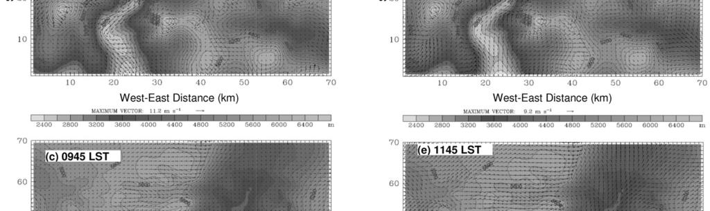
4 Aviation Hazards Over the Jomsom Airport of Nepal as Revealed by Numerical Simulation of Local Flows (c) (d) Fig. 4. Comparison of observed and the nearest grid point calculated wind speed at 10 m (a) and 30 m (b), temperature observed at 5 m and calculated at 2 m (c), and the wind direction observed at 48 m and calculated at 30 m (d) above the surface. The little difference that is seen in between the observation and calculation can be attributed to the differences in between the heights of observation and calculation level. Moreover, model calculates an average of 1 km 2 area whereas the measurement gives a pinpoint result. Thus, there are enough grounds to believe that present simulation has captured the very nitty-gritty of local flow fields along the Kali Gandaki Valley and over the Jomsom Airport during the calculation period. Spatial and temporal distribution of near surface wind Numerical predictions in consistent with the observed diurnal variation of winds show that there is an unprecedented asymmetry in the intensities of daytime upvalley and nighttime downvalley wind speeds along the Kali Gandaki Valley. During the late night until early morning, the near surface wind appears very weak from Marpha to Lo Manthang area but relatively strong drainage wind prevails over Marpha down to Ghasa area (Figs. 5a-b). Interestingly, small pocket area around the Kagbeni, typically, experiences drainage flows during the period but this drainage flow vanishes before reaching Jomsom area a few kilometers downstream. However, high Himalayan surfaces surrounding the valley appear very windy during the night and morning times. The flow situation remains nearly the same with minor changes until 0845 LST (Fig. 5c). Beyond 0845 LST the drainage flow quickly ceases and by 0945 LST, the whole valley floor from Ghasa up to Lo Manthan becomes calm and then the valley immediately develops strong upvalley wind that progressively moves upstream of the valley (Fig. 5d). By 1145 LST, a storm like wind prevails between Tukuche and Chuksang areas (Fig. 5e) that may reach beyond Lo Manthang and up into the Plateau of Tibet by 1245LST (Fig. 5f). The wind speed predicted and measured close to Chuksang (Fig. 4a-b) appears to be around 16 ms -1 but more than 19 ms -1 over Jomsom and Kagbeni areas (Fig. 5g). The wind speed appears to be maximum in between 1245 to 1645 LST. Importantly, the intensity of the near surface valley wind appears very weak or calm in between Ghasa to Tukuche area when peak wind speed prevails over the areas upstream to Tukuche (Fig. 5g). After 1645 LST, the near surface wind over the valley above Tukuche gradually begins to decrease and the whole valley from Ghasa to Lo Manthan and above becomes calm (Figs. 5h-i) and a gentle drainage wind starts to flow along the valley and eventually returns to the situation described earlier for early morning time. South-North Distance (km) (a) 0045 LST West-East Distance (km) 114

5 Ram P. Regmi 115

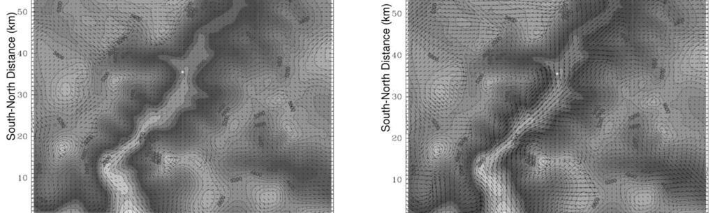
 it can be said that a moderately gentle drainage flow of about 300 m in deep may prevails over the Kali Gandaki Valley.")


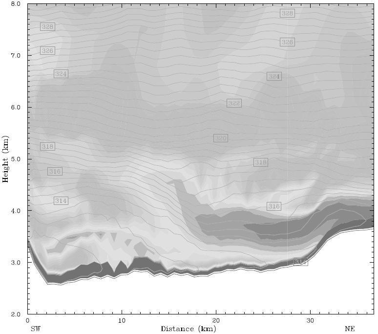
6 Aviation Hazards Over the Jomsom Airport of Nepal as Revealed by Numerical Simulation of Local Flows Fig. 5. Diurnal distribution of near surface wind over the Kali Gandaki Valley and Jomsom Airport on 16 May Vertical structure of flow fields Fig. 6 shows the vertical structure of the horizontal and vertical winds and the potential temperature distribution early morning times (e.g., see Fig. 6a) it can be said that a moderately gentle drainage flow of about 300 m in deep may prevails over the Kali Gandaki Valley. The atmosphere above this layer and up to 4 km above the mean sea level appears stagnated. However, a pronounced wind layer appears to flow aloft the stagnated layer in the direction opposite to the drainage flow. This particular local flow situation appears to continue more or less the same until 0545 LST (Fig. 6b). As the morning progresses, the stagnated layer above along the line A B (Fig. 5g). Examining the series of hourly predicted cross sectional distribution of horizontal wind during the late night and the drainage flow squeezes and the two wind layers tend to couple up. A weak subsidence from bottom level of the upper wind layer tends to feed the drainage flow after 0745 LST (Fig. 6c). The drainage flow disappears at 0945 LST and an appreciable subsidence from the upper wind layer down to the surface (Fig. 6d) that makes the weak downslope flow over the valley in between Marpha and Lo Manthang. This subsidence wind appears to be quickly replaced by strong and deep upvalley wind (Fig. 6e). (a) 0045 LST (b) 0545 LST 116
")
 1445")

")
 1145")
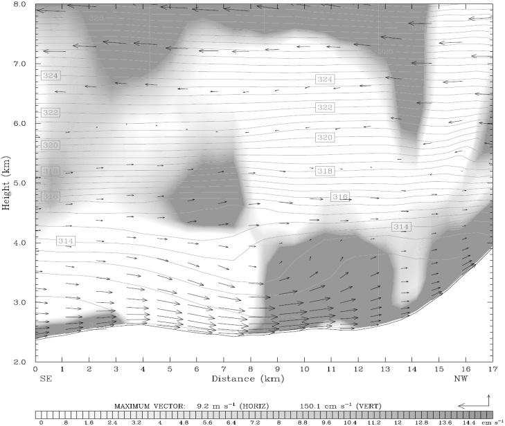
7 Ram P. Regmi (c) 0745 LST (f) 1445 LST (d) 0945 LST (9) 1945 LST (e) 1245 LST (h) 1145 LST 117
 and along the line C D (h-i) in Fig.")

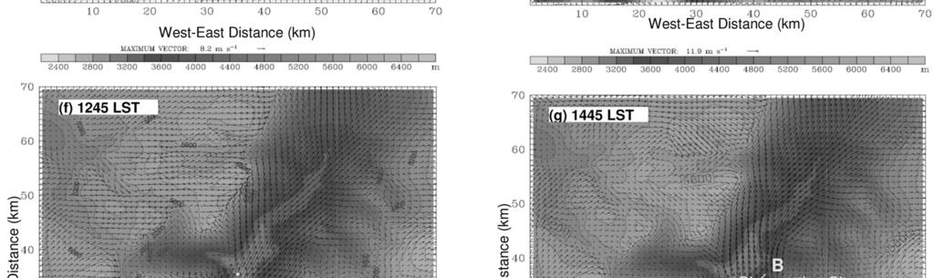
8 Aviation Hazards Over the Jomsom Airport of Nepal as Revealed by Numerical Simulation of Local Flows (i) 1445 LST Fig. 6. Cross-sectional distribution of potential temperature, horizontal and vertical winds along the line A B (a-g) and along the line C D (h-i) in Fig. 5g over the Kali Gandaki Valley and Jomsom Airport on 16 May The upvalley wind structure close to the noontime and in the afternoon strongly suggests that a hydraulic jump like flow accompanied with massive scale vertical wind speed and gravity wave excitations might have been occurring over the Jomsom-Kagbeni areas (Fig. 6f). The hydraulic jump like flow subsides by 1945 LST (Fig. 6g) and the near surface upvalley wind vanishes by 2045 LST gradually leading to the situation descried earlier for late night and early morning period. The night and morning time flow structure along the cross section C D (Fig. 5g for location) capture nearly the same nature of drainage flow along the ling A B but its intensity is relatively higher. Interestingly, over this area no wind layer remains aloft the drainage flow. It is important to note that in the late morning time an intense southeasterly upvalley wind flows up along the valley from Ghasa and Lete that turns southeasterly possibly guided by the C-shaped curbing of the gorge at Tukuche. In so doing, it creates a massive vertical wind at the corner of the valley (Fig. 6h). The depression of potential temperature above the upvalley wind layer and flow pattern again suggest that the flow over Tukuche area is supercritical. This particular nature of flow may continue until the afternoon time but in the late afternoon the upvalley wind lifts up over the Tukuche area and continues to feed over Marpha area keeping the Tukuche area calm (Fig. 6i). Aviation hazard over Jomsom airport The diurnal variation of wind over the Kali Gandaki River Valley appears to be highly hazardous for aviation activities beginning from late morning to evening. Very intense upvalley wind prevails along the gorge through which only a small aircraft can hardly make its way to Jomsom Airport. The upvalley wind also appears to make hydraulic jump like flow over the Jomsom Airport and is accompanied with wave excitations. Even during the morning time, the local flow system of the valley does not look favorable since a moderately gentle drainage wind prevails during the period with opposite flow aloft. A light aircraft of Nepal Airlines crashed at the bank of Kali Gandikai River in the process of takeoff at about 0930 LST on 16 May 2012 (Fig. 2c). It is of the interest to explore the possible reasons that might have led to this particular disaster during the period of late morning as the local flows during the period could be responsible for this crashing. During the period of 0845 and 0945 LST on the day (see Figs. 5c-d & 6c-d) significant subsidence appears to occur over the Jomsom Airport area causing a downslope wind over the surfaces of the airport. Since, wind characteristics measured at the airport were not available for us to incorporate in the discussion and the authors are not aware of the very details history of the incidence, it was not possible to derive definite conclusions. (a) 0045 LST 118
")
 0945")

")
 1245")
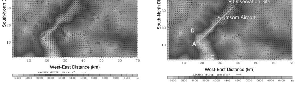
9 Ram P. Regmi (b) 0545 LST (e) 0945 LST (c) 0745 LST (f) 1045 LST (d) 0845 LST (g) 1245 LST 119
 in Fig. 5g over the Kali Gandaki Valley and Jomsom Airport on 16 May 2012.")

10 Aviation Hazards Over the Jomsom Airport of Nepal as Revealed by Numerical Simulation of Local Flows (h) 1445 LST (i) 2045 LST Richardson Number Fig. 7. Cross-sectional distributions of Richardson number along the line A B (a-g) in Fig. 5g over the Kali Gandaki Valley and Jomsom Airport on 16 May However, it can be said that the subsidence flow and downslope wind over the runway might have caused significant decrease in lifting capacity of the plane. The complex combination of the subsidence flow from wind layer about couple of hundred meters above the surface, reverse flow and thus developed so-called low-level turbulence in the immediate atmosphere over the runway might have leaded the aircraft to crash on the bank of the Kali Gandaki River soon its takeoff. Furthermore, the wind flow pattern over the surface and aloft during the period appears highly favorable to generate sufficient windshear - one of the major hazards for aviation especially when operating at low levels. Windshear is considered to be the second most important sources of turbulence. It is well known that light aircraft are prone to be buffeted, and are significantly affected even by light turbulence. Fig. 7 shows the evolution of turbulence evaluated via reference to the Richardson number over the Jomsom Airport during the day of 16 May It is believed that values of Richardson number between 0.25 and 1.0 allow the persistence of turbulence, whereas values greater than 1 will tend to cause any existing turbulence to subside. Judging from the values of the Richardson number distribution along the cross section of the line C D (Fig. 5g for orientation of the line), it can be said the boundary layer over the Jomsom Airport should have been strongly turbulent during the aircraft crashing time since the Richardson number is less than or about zero over the airport area. CONCLUSIONS Present study on the aviation hazards along the Kali Gandaki Valley and over the Jomsom Airport has indicated that there can be unexpected adverse meteorological activities that may lead to severe aircraft crashing. However, it should be noted that a single case study is obviously not sufficient to derive definite conclusions. Further in-depth numerical simulations taking number of case studies over Jomsom Airport and beyond incorporating the physical parameters, conditions, and capacity of the aircraft, the experience and views of pilots/passengers survived in the crash as well as the report of the probe commission of the crash have been planned for near future. Present findings have laid a strong basis to examine meteorological hazards for aviation activities over the highly complex terrain of Himalayas as well as throw lights on the need of documenting meteorological activities over the air route and airports that could possibly prevail. Future researches would be directed towards the real-time predictions of meteorological events over the airports and air routes for improved flight safety and comfort in Nepal. ACKNOWLEDGEMENTS This research was partially funded by University Grants Commission, Nepal. Authors are thankful to the Alternative Energy Promotion Center, Nepal Government for providing observation data for comparison. REFERENCES Egger, J., Bajrachaya, S., Egger, U., Heinrich, R., Reuder, J., Shakya, P., Wendt, H., and Wirth, V., Diurnal winds in the Himalayan Kali Gandaki valley. Part I: Observations. Mon. Wea. Rev. 12: Egger, J., Bajracharya, S., Heinrich, R., Kolb, P., Lammlein, S., Mech, M., Reuder, J., Schaper, W., Sakya, P., Schween, J., and Wendt, H., Dirunal Winds in the Himalayan Kali Gandaki Valley. Part III: Remotely Piloted Aircraft Soundings. Mon. Wea. Rev. 130: Skamarock, W. C., Klemp, J. B., Dudhia, J., Gill, D. O., Barker, D. M., Wang, W., and Powers, J. G., A description of the advanced research WRF NCAR/TN- 468+STR, 88 pp. Zängl, G., Egger, J. and Wirth, V Diurnal winds in the Himalayan Kali Gandaki valley. Part II: Modeling. Mon. Wea. Rev. 12:
Diurnal Winds in the Himalayan Kali Gandaki Valley. Part II: Modeling
 1062 MONTHLY WEATHER REVIEW Diurnal Winds in the Himalayan Kali Gandaki Valley. Part II: Modeling GÜNTHER ZÄNGL, JOSEPH EGGER, AND VOLKMAR WIRTH Meteorologisches Institut, Universität München, Munich,
Figure 1. Modeling domains used in WRF-ARW
 SIMULATION OF TRANSPORT AND DISPERSION OF POLLUTANTS FROM ELEVATED POINT SOURCES IN MISSISSIPPI GULF COAST USING A MESOSCALE ATMOSPHERIC DISPERSION MODELING SYSTEM Venkata Srinivas Challa, Jayakumar Indracanti,
10.6 The Dynamics of Drainage Flows Developed on a Low Angle Slope in a Large Valley Sharon Zhong 1 and C. David Whiteman 2
 10.6 The Dynamics of Drainage Flows Developed on a Low Angle Slope in a Large Valley Sharon Zhong 1 and C. David Whiteman 2 1Department of Geosciences, University of Houston, Houston, TX 2Pacific Northwest
The Cooling Effect of Green Strategies Proposed in the Hanoi Master Plan for Mitigation of Urban Heat Island
 The Cooling Effect of Green Strategies Proposed in the Hanoi Master Plan for Mitigation of Urban Heat Island Andhang Rakhmat Trihamdani, M.Eng. [Grad. School for IDEC, Hiroshima Univ., Japan] andhang.rt@gmail.com
A Numerical Simulation of Convectively Induced Turbulence (CIT) above Deep Convection
 above Deep Convection") A Numerical Simulation of Convectively Induced Turbulence (CIT) above Deep Convection Jung-Hoon Kim and Hye-Yeong Chun Department of Atmospheric Sciences Yonsei University, Seoul, Korea 1. Introduction
A Numerical Simulation of Convectively Induced Turbulence (CIT) above Deep Convection Jung-Hoon Kim and Hye-Yeong Chun Department of Atmospheric Sciences Yonsei University, Seoul, Korea 1. Introduction
Diurnal Winds in the Himalayan Kali Gandaki Valley. Part I: Observations
 1106 MONTHLY WEATHER REVIEW Diurnal Winds in the Himalayan Kali Gandaki Valley. Part I: Observations JOSEPH EGGER Meteorologisches Institut, Universität München, Munich, Germany SAPTA BAJRACHAYA Department
Chapter 2. Turbulence and the Planetary Boundary Layer
 Chapter 2. Turbulence and the Planetary Boundary Layer In the chapter we will first have a qualitative overview of the PBL then learn the concept of Reynolds averaging and derive the Reynolds averaged
High-resolution simulations of mountain weather improved with observations from small unmanned aircraft
 High-resolution simulations of mountain weather improved with observations from small unmanned aircraft Hálfdán Ágústsson, Haraldur Ólafsson, Marius O. Johannessen, Joachim Reuder, Dubravka Rasol and Ólafur
Sea and Land Breezes METR 4433, Mesoscale Meteorology Spring 2006 (some of the material in this section came from ZMAG)
") Sea and Land Breezes METR 4433, Mesoscale Meteorology Spring 2006 (some of the material in this section came from ZMAG) 1 Definitions: The sea breeze is a local, thermally direct circulation arising from
Sea and Land Breezes METR 4433, Mesoscale Meteorology Spring 2006 (some of the material in this section came from ZMAG) 1 Definitions: The sea breeze is a local, thermally direct circulation arising from
2.4. Applications of Boundary Layer Meteorology
 2.4. Applications of Boundary Layer Meteorology 2.4.1. Temporal Evolution & Prediction of the PBL Earlier, we saw the following figure showing the diurnal evolution of PBL. With a typical diurnal cycle,
Wind Power. Kevin Clifford METR 112 April 19, 2011
 Wind Power Kevin Clifford METR 112 April 19, 2011 Outline Introduction Wind Turbines Determining Wind Power Output The Price of Wind Power Wind Power Availability across the World and US California Wind
Idealized Numerical Modeling of a Land/Sea Breeze
 Idealized Numerical Modeling of a Land/Sea Breeze Jeremy A. Gibbs School of Meteorology, University of Oklahoma 3 December 2008 1 Introduction With references in the Bible, the land and sea breeze is one
FINAL REPORT. Wind Assessment for: NEW OFFICE BUILDING AT ESSENDON FIELDS Essendon, Victoria, Australia
 FINAL REPORT Wind Assessment for: NEW OFFICE BUILDING AT ESSENDON FIELDS Essendon, Victoria, Australia Prepared for: Essendon Fields Pty Ltd Essendon Fields House Level 2, 7 English Street Essendon Fields
OPERATIONAL USE OF A WIND PROFILER FOR AVIATION METEOROLOGY ABSTRACT
 OPERATIONAL USE OF A WIND PROFILER FOR AVIATION METEOROLOGY Miguel Angel Pelacho, Darío Cano, Eugenio Ayensa Spanish Agency of Meteorology (AEMET) Parque del Buen Retiro, Apdo. 285, 28080-MADRID E-mail:
Conditions for Offshore Wind Energy Use
 Carl von Ossietzky Universität Oldenburg Institute of Physics Energy Meteorology Group Detlev Heinemann Conditions for Offshore Wind Energy Use Detlev Heinemann ForWind Carl von Ossietzky Universität Oldenburg
An Analysis of the South Florida Sea Breeze Circulation: An Idealized Study
 An Analysis of the South Florida Sea Breeze Circulation: An Idealized Study John Cangialosi University of Miami/RSMAS Abstract This experiment is an idealized study (removal of mean large scale flow) to
1.6 HIGH RESOLUTION SIMULATIONS OF THE ISLAND-INDUCED CIRCULATIONS FOR THE ISLAND OF HAWAII DURING HaRP. Yang Yang and Yi-Leng Chen*
 1.6 HIGH RESOLUTION SIMULATIONS OF THE ISLAND-INDUCED CIRCULATIONS FOR THE ISLAND OF HAWAII DURING HaRP Yang Yang and Yi-Leng Chen* Department of Meteorology University of Hawaii at Manoa Honolulu, Hawaii
INTRODUCTION * Corresponding author address: Michael Tjernström, Stockholm University, Department of Meteorology, SE-
 4.12 NEW ENGLAND COASTAL BOUNDARY LAYER MODELING Mark Žagar and Michael Tjernström * Stockholm University, Stockholm, Sweden Wayne Angevine CIRES, University of Colorado, and NOAA Aeronomy Laboratory,
Numerical Study of Diurnal Circulations of Tropical Coastal Site Visakhapatnam Using the ARW MesoScale Model
 (An ISO 3297: 2007 Certified Organization Numerical Study of Diurnal Circulations of Tropical Coastal Site Visakhapatnam Using the ARW MesoScale Model 1 V. LakshmanaRao, 2P.Satish 1 Assistant Professor,
WAVE BREAKING OVER LOCAL TOPOGRAPHY DURING THE MAP IOP 15 MISTRAL EVENT: OBSERVATIONS AND HIGH-RESOLUTION NUMERICAL SIMULATIONS
 WAVE BREAKING OVER LOCAL TOPOGRAPHY DURING THE MAP IOP 15 MISTRAL EVENT: OBSERVATIONS AND HIGH-RESOLUTION NUMERICAL SIMULATIONS Vincent Guénard 1, Gilles Tedeschi 1, Philippe Drobinski 2, Jean Luc Caccia
Gravity waves in stable atmospheric boundary layers
 Gravity waves in stable atmospheric boundary layers Carmen J. Nappo CJN Research Meteorology Knoxville, Tennessee 37919, USA Abstract Gravity waves permeate the stable atmospheric planetary boundary layer,
6.28 PREDICTION OF FOG EPISODES AT THE AIRPORT OF MADRID- BARAJAS USING DIFFERENT MODELING APPROACHES
 6.28 PREDICTION OF FOG EPISODES AT THE AIRPORT OF MADRID- BARAJAS USING DIFFERENT MODELING APPROACHES Cecilia Soriano 1, Darío Cano 2, Enric Terradellas 3 and Bill Physick 4 1 Universitat Politècnica de
Numerical Approach on the Mechanism of Precipitation-Topography Relationship in Mountainous Complex Terrain
 Numerical Approach on the Mechanism of Precipitation-Topography Relationship in Mountainous Complex Terrain Yoshiharu, S. 1, S. Miyata 2, E. Nakakita 3 and M. Hasebe 4 1 Faculty of Engineering, Utsunomiya
PGF. Pressure Gradient. Wind is horizontal movement of the air or other word air in motion. Forces affecting winds 2/14/2017
 Winds Wind is horizontal movement of the air or other word air in motion. Forces affecting winds 1. Pressure gradient force a. High pressure flows to low pressure b. Pressure gradient = difference in pressure
Preliminary Study of Aircraft Dynamics and Performance: High Gust Condition Aspect
 Advances in Aerospace Science and Applications. ISSN 2277-3223 Volume 3, Number 2 (2013), pp. 57-62 Research India Publications http://www.ripublication.com/aasa.htm Preliminary Study of Aircraft Dynamics
August 1990 H. Kondo 435. A Numerical Experiment on the Interaction between Sea Breeze and
 August 1990 H. Kondo 435 A Numerical Experiment on the Interaction between Sea Breeze and Valley Wind to Generate the so-called "Extended Sea Breeze" By Hiroaki Kondo National Research Institute for Pollution
Modelling atmospheric stability with CFD: The importance of tall profiles
 ENERGY Modelling atmospheric stability with CFD: The importance of tall profiles VindKraftNet Seminar on Profiles Jean-François Corbett, Global Head of CFD Service 1 SAFER, SMARTER, GREENER DNV GL CFD
Bora flow over the complex terrain of the mid- Adriatic area
 Bora flow over the complex terrain of the mid- Adriatic area Kristian Horvath 1, kristian.horvath@cirus.dhz.hr, Željko Večenaj 2, Branko Grisogono 2 1 Research Department, Meteorological and Hydrological
ABSTRACT INTRODUCTION
 Numerical investigation of the formation of elevated pollution layers over the Los Angeles air basin Rong Lu, R.P. Turco Department of Atmospheric Sciences, University of California, Los Angeles, 405 Hilgard
Ermenek Dam and HEPP: Spillway Test & 3D Numeric-Hydraulic Analysis of Jet Collision
 Ermenek Dam and HEPP: Spillway Test & 3D Numeric-Hydraulic Analysis of Jet Collision J.Linortner & R.Faber Pöyry Energy GmbH, Turkey-Austria E.Üzücek & T.Dinçergök General Directorate of State Hydraulic
Gravity Waves in Shear and
 Gravity Waves in Shear and Implications for Organized Convection Sam Stechmann (Wisconsin) and Andy Majda (NYU) (paper in J. Atmos. Sci., 29) Workshop on Modelling Monsoon Intraseasonal Variability Busan,
Emission Inventory Evaluation Using DISCOVER-AQ Aircraft Data
 Emission Inventory Evaluation Using DISCOVER-AQ Aircraft Data Gary McGaughey, David Allen (PI) and Elena McDonald-Buller (co-pi) Center for Energy and Environmental Resources The University of Texas at
A Numerical Study of the Thermally Driven Plain-to-Basin Wind over Idealized Basin Topographies
 606 JOURNAL OF APPLIED METEOROLOGY A Numerical Study of the Thermally Driven Plain-to-Basin Wind over Idealized Basin Topographies STEPHAN F. J. DE WEKKER,* SHIYUAN ZHONG, JEROME D. FAST, AND C. DAVID
Impact of Sea Breeze Fronts on Urban Heat Island & Air Quality in Texas
 Impact of Sea Breeze Fronts on Urban Heat Island & Air Quality in Texas Xiao-Ming Hu Center for Analysis and Prediction of Storms, School of Meteorology University of Oklahoma July 14, 2015 at LanZhou
Mesoscale Meteorology
 Mesoscale Meteorology METR 4433 Spring 2015 3.4 Drylines The dryline is a mesoscale phenomena whose development and evaluation is strongly linked to the PBL. In this section, we will consider its general
A Wet-Season Rainfall Climatology to Support Airline Arrivals at Key West Matthew Bloemer and Andy Devanas NWS WFO Key West, FL
 A Wet-Season Rainfall Climatology to Support Airline Arrivals at Key West Matthew Bloemer and Andy Devanas NWS WFO Key West, FL Introduction and Motivations The Island of Key West is served by an airport
2. THE NEW ENGLAND AIR QUALITY STUDY
 P2.4 NEW ENGLAND COASTAL AIR POLLUTION DISPERSION MODELING Michael Tjernström * and Mark Žagar Stockholm University, Stockholm, Sweden Wayne Angevine CIRES, University of Colorado, and NOAA Aeronomy Laboratory,
NUMERICAL INVESTIGATION OF THE FLOW BEHAVIOUR IN A MODERN TRAFFIC TUNNEL IN CASE OF FIRE INCIDENT
 - 277 - NUMERICAL INVESTIGATION OF THE FLOW BEHAVIOUR IN A MODERN TRAFFIC TUNNEL IN CASE OF FIRE INCIDENT Iseler J., Heiser W. EAS GmbH, Karlsruhe, Germany ABSTRACT A numerical study of the flow behaviour
Analysis of NAM Forecast Wind Shear for Dissipation of Mesoscale Convective Systems
 Analysis of NAM Forecast Wind Shear for Dissipation of Mesoscale Convective Systems MATTHEW P. HOFFMAN Meteorology Program, Iowa State University, Ames, IA Mentor: David Flory Department of Geological
It seemed that airplanes arriving and departing AVWEATHER
 BY ED BROTAK It seemed that airplanes arriving and departing from Will Rogers World Airport in Oklahoma City, Oklahoma, United States, on the morning of Aug. 3, 2012, would have few problems with wind
Abrupt marine boundary layer changes revealed by airborne in situ and lidar measurements
 Abrupt marine boundary layer changes revealed by airborne in situ and lidar measurements David A. Rahn 1, Thomas R. Parish 2, and David Leon 2 1 Univeristy of Kansas 2 Univeristy of Wyoming Precision Atmospheric
The dryline is a mesoscale phenomena whose development and evaluation is strongly linked to the PBL.
 2.2. Development and Evolution of Drylines The dryline is a mesoscale phenomena whose development and evaluation is strongly linked to the PBL. Text books containing sections on dryline: The Dry Line.
Optimized use of real-time vertical-profile wind data and fast modelling for prediction of airflow over complex terrain
 METEOROLOGICAL APPLICATIONS Meteorol. Appl. 23: 182 19 (216) Published online February 216 in Wiley Online Library (wileyonlinelibrary.com) DOI: 1.12/met.44 Optimized use of real-time vertical-profile
Large-eddy simulation study of effects of clearing in forest on wind turbines
 Large-eddy simulation study of effects of clearing in forest on wind turbines J. Matsfelt 1 and L. Davidson 1 1 Chalmers University of Technology, Dep. of Mechanics and Maritime Sciences, Div. of Fluid
Seasonal Evaluation of Temperature Inversion
 Seasonal Evaluation of Temperature Inversion Kandil, H A 1, Kader M M. A 2, Moaty, A A. 2, Elhadidi, B 3, Sherif, A.O. 3 The seasonal evaluation of the temperature inversion over Cairo-Egypt is examined
Super-parameterization of boundary layer roll vortices in tropical cyclone models
 DISTRIBUTION STATEMENT A. Approved for public release; distribution is unlimited. Super-parameterization of boundary layer roll vortices in tropical cyclone models PI Isaac Ginis Graduate School of Oceanography
AIRFLOW GENERATION IN A TUNNEL USING A SACCARDO VENTILATION SYSTEM AGAINST THE BUOYANCY EFFECT PRODUCED BY A FIRE
 - 247 - AIRFLOW GENERATION IN A TUNNEL USING A SACCARDO VENTILATION SYSTEM AGAINST THE BUOYANCY EFFECT PRODUCED BY A FIRE J D Castro a, C W Pope a and R D Matthews b a Mott MacDonald Ltd, St Anne House,
LES* IS MORE! * L ARGE E DDY S IMULATIONS BY VORTEX. WindEnergy Hamburg 2016
 LES* IS MORE! * L ARGE E DDY S IMULATIONS BY VORTEX WindEnergy Hamburg 2016 OUTLINE MOTIVATION Pep Moreno. CEO, BASIS Alex Montornés. Modelling Specialist, VALIDATION Mark Žagar. Modelling Specialist,
LOW LAYER WIND SHEAR OVER DAKAR
 LOW LAYER WIND SHEAR OVER DAKAR Dr Cheikh Sadibou SOW ASECNA Senior Meteorologist Abstract : Low layer wind shears are dangerous for planes. Their observation and study are one of the main fields where
Polar storms and polar jets: Mesoscale weather systems in the Arctic & Antarctic
 Polar storms and polar jets: Mesoscale weather systems in the Arctic & Antarctic Ian Renfrew School of Environmental Sciences, University of East Anglia ECMWF-WWRP/Thorpex Polar Prediction Workshop 24-27
Civil Air Patrol Auxiliary of the United States Air Force
 Mountain Flying Qualification Course Civil Air Patrol Auxiliary of the United States Air Force Mountain Weather Slopes Most U.S. mountain ranges are oriented north-south, while the prevailing winds are
Boundary layer meso-scale flows. Hannu Savijärvi University of Helsinki
 Boundary layer meso-scale flows Hannu Savijärvi University of Helsinki Contents Mechanical channeling Thermal heat islands Slope winds Sea breezes Thermal channeling on a sea gulf spring, early summer
Synoptic features of orographically enhanced heavy rainfall on the east coast of Korea associated with Typhoon Rusa (2002)
") Click Here for Full Article GEOPHYSICAL RESEARCH LETTERS, VOL. 34, L02803, doi:10.1029/2006gl028592, 2007 Synoptic features of orographically enhanced heavy rainfall on the east coast of Korea associated
Click Here for Full Article GEOPHYSICAL RESEARCH LETTERS, VOL. 34, L02803, doi:10.1029/2006gl028592, 2007 Synoptic features of orographically enhanced heavy rainfall on the east coast of Korea associated
Predicting and simulating wake in stable conditions
 Predicting and simulating wake in stable conditions Model chain evaluation and an example Mark Žagar, Gregory S. Oxley, Yavor V. Hristov Vestas Wind Systems A/S, Plant Siting and Forecasting 15 January
Influence of Heat Transport by Sea Breezes on Inland Temperature in the Osaka Area
 Academic Article Journal of Heat Island Institute International Vol. 9-2 (2) Influence of Heat Transport by Sea Breezes on Inland Temperature in the Osaka Area Atsumasa Yoshida* Junichi Yashiro* Xinbo
A R e R v e iew e w on o n th t e h e Us U e s s e s of o Clou o d u - (S ( y S s y t s e t m e )-Re R sol o ving n Mod o e d ls Jeff Duda
-Re R sol o ving n Mod o e d ls Jeff Duda") A Review on the Uses of Cloud- (System)-Resolving Models Jeff Duda What is a Cloud-Resolving-Model (CRM)? General definition: A model with the following properties Resolution high enough to be able to
A Review on the Uses of Cloud- (System)-Resolving Models Jeff Duda What is a Cloud-Resolving-Model (CRM)? General definition: A model with the following properties Resolution high enough to be able to
Modeling of Mountain Waves in T-REX
 10.6 Modeling of Mountain Waves in T-REX Steven E. Koch 1,2, Ligia R. Bernardet 1,2, Brian D. Jamison 1,3, and John M. Brown 1 1 NOAA / Earth Systems Research Laboratory (ESRL), Boulder, Colorado 2 Developmental
Darwin s mid-evening surge
 Darwin s mid-evening surge Gerald L. Thomsen and Roger K. Smith Meteorological Institute, University of Munich, Germany November 11, 2009 Corresponding author: Gerald Thomsen, gerald@meteo.physik.uni-muenchen.de
Xiaoli Guo Larsén,* Søren Larsen and Andrea N. Hahmann Risø National Laboratory for Sustainable Energy, Roskilde, Denmark
 Quarterly Journal of the Royal Meteorological Society Q. J. R. Meteorol. Soc. 138: 274 279, January 2012 A Notes and Correspondence Origin of the waves in A case-study of mesoscale spectra of wind and
ASSESSMENT OF SEA BREEZE CHARACTERISTICS FROM SODAR ECHOGRAMS
 ASSESSMENT OF SEA BREEZE CHARACTERISTICS FROM SODAR ECHOGRAMS SUNEETHA RANI. JUPUDI Prof. M. PURNACHANDRA RAO Department of Physics, Andhra University, Visakhapatnam, India. ABSTRACT The SODAR echograms
Hong Kong International Airport North Runway South Runway
 P.1 Atmospheric Waves Associated with a Valley of Lantau Island: Observation, Theory and Numerical Simulation P.W. Chan * Hong Kong Observatory, Hong Kong, China 1. INTRODUCTION The Hong Kong Observatory
Darwin s mid-evening surge
 Australian Meteorological and Oceanographic Journal 60 (2010) 25-36 Darwin s mid-evening surge Gerald L. Thomsen and Roger K. Smith Meteorological Institute, University of Munich, Germany (Manuscript received
EVE 402/502 Air Pollution Generation and Control. Introduction. Intro, cont d 9/18/2015. Chapter #3 Meteorology
 EVE 402/502 Air Pollution Generation and Control Chapter #3 Meteorology Introduction Meteorology is the study and forecasting of weather changes resulting from large-scale atmospheric circulation Characteristics
The Dynamics of Northwest Summer Winds over the Santa Barbara Channel
 1042 MONTHLY WEATHER REVIEW VOLUME 129 The Dynamics of Northwest Summer Winds over the Santa Barbara Channel ERIC D. SKYLLINGSTAD AND PHILIP BARBOUR College of Oceanic and Atmospheric Sciences, Oregon
1 INTRODUCTION. Figure 2: Synoptical situation at the beginning of the simulation: 5th January 1999 at 12UTC.
 2.2 NOCTURNAL CIRCULATIONS UNDER WEAK PRESSURE GRADIENTS IN THE ISLAND OF MALLORCA J. Cuxart and M.A. Jiménez Universitat de les Illes Balears, Spain 1 INTRODUCTION To study the local nocturnal circulations
A Theory for Strong Long-Lived Squall Lines Revisited
 A Theory for Strong Long-Lived Squall Lines Revisited MORRIS L. WEISMAN AND RICHARD ROTUNNO National Center for Atmospheric Research,* Boulder, Colorado (Manuscript received 29 April 2002, in final form
18 Flight Hazards over High Ground
 18 Flight Hazards over High Ground meteorology 18.1 Mountain Effect on Fronts When a warm front passes a mountain range, the air, is lifted over the mountain and will strengthen the formation of cloud
Turbulence forecasts based on upper-air soundings
 OC3570 Turbulence forecasts based on upper-air soundings By Greg Ireton Introduction The objective of this paper is to make turbulence forecasts from upper-air data by making Richardson s number calculations
Increased Project Bankability : Thailand's First Ground-Based LiDAR Wind Measurement Campaign
 Increased Project Bankability : Thailand's First Ground-Based LiDAR Wind Measurement Campaign Authors: Velmurugan. k, Durga Bhavani, Ram kumar. B, Karim Fahssis As wind turbines size continue to grow with
Vertical Motion and Atmospheric Stability
 Lesson 4 Vertical Motion and Atmospheric Stability This lesson describes the vertical structure of the atmosphere, atmospheric stability and the corresponding vertical motion. Adiabatic diagrams are introduced
Title: Gravity wave over flat terrain.
 Title: Gravity wave over flat terrain. Author: Daniel L. Johnson (MD), Mayo Clinic Health System, drdan@wwt.net Abstract: Wave is everywhere throughout the atmosphere, whereever shear exists. Standing
1.5 THE LAND BREEZE CHARACTERISTICS IN ISRAEL DURING THE SUMMER BY THE MM5 MODEL
 1. THE LAND BREEZE CHARACTERISTICS IN ISRAEL DURING THE SUMMER BY THE MM MODEL S. Berkovic and Y. Feliks Department of Mathematics, Israel Institute for Biological Research P.O.B 19, Ness-Ziona, Israel
Wind: Small-scale and Local Systems
 Wind: Small-scale and Local Systems Scales of Atmospheric Motion Atmospheric motions/phenomena occur on many diverse spatial and temporal scales. Weather forecasters tend to focus on Mesoscale and synoptic
s rm o ffect St e E ak L
 Lake Effect Storms Cold Air Moving Over Water Surface Steam Fog Cold air off continent moves over relatively warm water surface Fluxes of heat and moisture from water into air (bulk formulae): F ( ) H
DUE TO EXTERNAL FORCES
 17B.6 DNS ON GROWTH OF A VERTICAL VORTEX IN CONVECTION DUE TO EXTERNAL FORCES Ryota Iijima* and Tetsuro Tamura Tokyo Institute of Technology, Yokohama, Japan 1. INTRODUCTION Various types of vertical vortices,
Investigation on Deep-Array Wake Losses Under Stable Atmospheric Conditions
 Investigation on Deep-Array Wake Losses Under Stable Atmospheric Conditions Yavor Hristov, Mark Zagar, Seonghyeon Hahn, Gregory Oxley Plant Siting and Forecasting Vestas Wind Systems A/S Introduction Introduction
Atmospheric Dispersion, Transport and Deposition. Dispersion. Wind Speed. EOH 468 Spring 2008 Dr. Peter Bellin, CIH, Ph.D.
 Atmospheric Dispersion, Transport and Deposition EOH 468 Spring 2008 Dr. Peter Bellin, CIH, Ph.D. Dispersion Atmospheric process affect dilution. Wind speed and lapse rate impact on emissions. Planetary
Performance of three Selected Convective Schemes for Predicting Indian Summer Monsoon Rainfall using RegCM4.4
 Performance of three Selected Convective Schemes for Predicting Indian Summer Monsoon Rainfall using RegCM4.4 A.K.M. Saiful Islam Professor Institute of Water and Flood Management Bangladesh University
P2.25 SUMMER-TIME THERMAL WINDS OVER ICELAND: IMPACT OF TOPOGRAPHY. Bergen
 P2.25 SUMMER-TIME THERMAL WINDS OVER ICELAND: IMPACT OF TOPOGRAPHY Haraldur Ólafsson 1 and Hálfdán Ágústsson 2 1 University of Iceland, Bergen School of Meteorology, Geophysical Institute, University of
ISOLATION OF NON-HYDROSTATIC REGIONS WITHIN A BASIN
 ISOLATION OF NON-HYDROSTATIC REGIONS WITHIN A BASIN Bridget M. Wadzuk 1 (Member, ASCE) and Ben R. Hodges 2 (Member, ASCE) ABSTRACT Modeling of dynamic pressure appears necessary to achieve a more robust
Outline. Wind Turbine Siting. Roughness. Wind Farm Design 4/7/2015
 Wind Turbine Siting Andrew Kusiak 2139 Seamans Center Iowa City, Iowa 52242-1527 andrew-kusiak@uiowa.edu Tel: 319-335-5934 Fax: 319-335-5669 http://www.icaen.uiowa.edu/~ankusiak Terrain roughness Escarpments
SENSITIVITY OF DEVELOPING TROPICAL CYCLONES TO INITIAL VORTEX DEPTH AND THE HEIGHT OF ENVIRONMENTAL DRY AIR
 6D.6 SENSITIVITY OF DEVELOPING TROPICAL CYCLONES TO INITIAL VORTEX DEPTH AND THE HEIGHT OF ENVIRONMENTAL DRY AIR Peter M. Finocchio*, Sharanya J. Majumdar, David S. Nolan University of Miami - RSMAS, Miami,
IVAO International Virtual Aviation Organization Training department
 1 Introduction IVAO International Virtual Aviation Organization Training department TRAFFIC PATTERN DESCRIPTION An aerodrome traffic pattern is used by VFR traffic for training purpose or to prepare the
Influence of NOx/VOC emission-reduction on ozone levels in the Mediterranean area
 EUROPEAN COMMISSION JOINT RESEARCH CENTRE ENVIRONMENT INSTITUTE Environmental Modelling Task Force Influence of NOx/VOC emission-reduction on ozone levels in the Mediterranean area C. Cuvelier, P. Thunis
OPERATIONAL AMV PRODUCTS DERIVED WITH METEOSAT-6 RAPID SCAN DATA. Arthur de Smet. EUMETSAT, Am Kavalleriesand 31, D Darmstadt, Germany ABSTRACT
 OPERATIONAL AMV PRODUCTS DERIVED WITH METEOSAT-6 RAPID SCAN DATA Arthur de Smet EUMETSAT, Am Kavalleriesand 31, D-64295 Darmstadt, Germany ABSTRACT EUMETSAT started its Rapid Scanning Service on September
Investigation of the Causes of Wind Turbine Blade Damage at Shiratakiyama Wind Farm in Japan A Computer Simulation Based Approach
 Reports of Research Institute for Applied Mechanics, Kyushu University No.141 (13 25) September 2011 13 Investigation of the Causes of Wind Turbine Blade Damage at Shiratakiyama Wind Farm in Japan A Computer
Meteorology. Circle the letter that corresponds to the correct answer
 Chapter 4 Worksheet 3 Meteorology Name: Circle the letter that corresponds to the correct answer 1) Natural convection and turbulence are most likely to occur when: a) temperature decreases rapidly with
COnstraining ORographic Drag Effects (COORDE)
") COnstraining ORographic Drag Effects (COORDE) A GASS/WGNE Modeling Intercomparison Project Annelize van Niekerk and Irina Sandu Contents 1 Introduction....................................................
COnstraining ORographic Drag Effects (COORDE) A GASS/WGNE Modeling Intercomparison Project Annelize van Niekerk and Irina Sandu Contents 1 Introduction....................................................
Gravity waves and bores. Material kindly provided by Dr. Steven Koch GSD NOAA (Boulder, CO)
") Gravity waves and bores Material kindly provided by Dr. Steven Koch GSD NOAA (Boulder, CO) Presented at Iowa State University 11 April 2005 What is a gravity wave? An oscillation caused by the displacement
Gravity waves and bores Material kindly provided by Dr. Steven Koch GSD NOAA (Boulder, CO) Presented at Iowa State University 11 April 2005 What is a gravity wave? An oscillation caused by the displacement
8.4 COASTAL WIND ANOMALIES AND THEIR IMPACT ON SURFACE FLUXES AND PROCESSES OVER THE EASTERN PACIFIC DURING SUMMER
 8.4 COASTAL WIND ANOMALIES AND THEIR IMPACT ON SURFACE FLUXES AND PROCESSES OVER THE EASTERN PACIFIC DURING SUMMER Ragoth Sundararajan * and Darko Koraĉin Desert Research Institute, Reno, NV, USA Michael
On the use of rotor equivalent wind speed to improve CFD wind resource mapping. Yavor V. Hristov, PhD Plant Performance and Modeling Vestas TSS
 On the use of rotor equivalent wind speed to improve CFD wind resource mapping Yavor V. Hristov, PhD Plant Performance and Modeling Vestas TSS Firestorm- Number 53 on Top500 list from June 2011 14664 processors
Exploring wave-turbulence interaction through LES modeling
 Exploring wave-turbulence interaction through LES modeling Mireia Udina 1 Jielun Sun 2 M. Rosa Soler 1 Branko Kosović 2 1. Dept. Astronomia i Meteorologia Universitat de Barcelona, Barcelona, Catalunya
Lecture 7. The Indian monsoon: is it a gigantic land-sea breeze?
 Lecture 7 The Indian monsoon: is it a gigantic land-sea breeze? In the next set of lectures I am going to discuss the different hypotheses put forth for the basic system responsible for the monsoon. I
Supplementary Material for Satellite Measurements Reveal Persistent Small-Scale Features in Ocean Winds Fig. S1.
 Supplementary Material for Satellite Measurements Reveal Persistent Small-Scale Features in Ocean Winds by D. B. Chelton, M. G. Schlax, M. H. Freilich and Ralph F. Milliff Fig. S1. Global 4-year average
EXTREME WIND GUSTS IN LARGE-EDDY SIMULATIONS OF TROPICAL CYCLONES
 The National Center for Atmospheric Research (NCAR) is sponsored by the National Science Foundation (NSF) EXTREME WIND GUSTS IN LARGE-EDDY SIMULATIONS OF TROPICAL CYCLONES George Bryan National Center
6.4 ASSESSMENT OF WIND SHEAR FORECAST PERFORMANCE AND IMPLICATIONS ON WIND COMPRESSION IMPACTS
 6.4 ASSESSMENT OF WIND SHEAR FORECAST PERFORMANCE AND IMPLICATIONS ON WIND COMPRESSION IMPACTS Colleen Reiche*, Michael Robinson, Bernard Niu, Dennis O Donnell, Mike Kay AvMet Applications, Inc., Reston,
Accident Prevention Program
 Accident Prevention Program Wind Shear "Tonto 55, final controller, how do you read...?" "55, loud and clear." This has been a good flight thought the Instructor Pilot (IP) as the pilot in front smoothly
Atmospheric Waves James Cayer, Wesley Rondinelli, Kayla Schuster. Abstract
 Atmospheric Waves James Cayer, Wesley Rondinelli, Kayla Schuster Abstract It is important for meteorologists to have an understanding of the synoptic scale waves that propagate thorough the atmosphere
Local Winds. Please read Ahrens Chapter 10
 Local Winds Please read Ahrens Chapter 10 Scales of Motion Microscale: meters Turbulent eddies Formed by mechanical disturbance or convection Lifetimes of minutes Mesoscale: km s to 100 s of km s Local
The impacts of explicitly simulated gravity waves on large-scale circulation in the
 The impacts of explicitly simulated gravity waves on large-scale circulation in the Southern Hemisphere. Linda Mudoni Department of Geological and Atmospheric Sciences October 2003 Introduction In the