Influence of NOx/VOC emission-reduction on ozone levels in the Mediterranean area
|
|
|
- Allison Ada Higgins
- 5 years ago
- Views:
Transcription
1 EUROPEAN COMMISSION JOINT RESEARCH CENTRE ENVIRONMENT INSTITUTE Environmental Modelling Task Force Influence of NOx/VOC emission-reduction on ozone levels in the Mediterranean area C. Cuvelier, P. Thunis Introduction The EU-wide abatement strategy, as described in the Ozone Position Paper, focusses on the large scale ozone levels (cf D. Simpson, 1998, The scientific basis of NOx protocols and the EU ozone control strategy, paper at EUROTRAC-2). It is based on model calculations with a resolution of 150 km and does not address peaks of spatial dimensions below this size. It is known that on the regional and urban scale peaks can occur, superimposed on the larger scale background. The target values and the LTO s also apply to these peaks. It is, however, not practical to attempt to devise a detailed EU strategy for such peaks, since these may occur under quite different conditions, and the best way to combat such peaks may depend on the local situation. Because of this, it is left to the Member States to choose the best approach to abate local ozone levels. It is, however, important to investigate how large measures affect the local situation. In this contribution to the study of the strategy for the regional (meso-) scale, we will concentrate on the situation in the Mediterranean area with a case study from the Burriana area (near Valencia, Spain). Meteorology and air pollution in the Mediterranean For general reference, see Millan et al, 1992, MECAPIP report; Millan et al, 1996, Atmos Env. 30, ; Millan, Salvador, Mantilla, Kallos, 1997, J. Geophys. Res, 102, ; Millan, 1998, Ozone Position Paper, annex C; and Kallos, paper presented at EUROTRAC-2. There is experimental evidence for chronic air pollution problems in Southern Europe, e.g. on the Spanish east coast the ozone threshold level of the EC directive 92/72/CEE for damages to vegetation (65 µ g/m 3 as a 24 hours average) is exceeded for more than 6 months of the year, the one for human health (110 µ g/m 3, 8 hour average) for at least four months, and the one for information to the population (180 µ g/m 3, hourly average) can also be exceeded frequently from April to August. This situation is the norm for coastal regions surrounding the western Mediterranean Basin. Convection and recirculation seem to predominate in the western Mediterranean area, possibly leading to a build-up and cooking of pollutants. Horizontal advection seems to predominate in the eastern Mediterranean area, in a way that air pollution from urban areas within the region is transported as plumes over the sea.
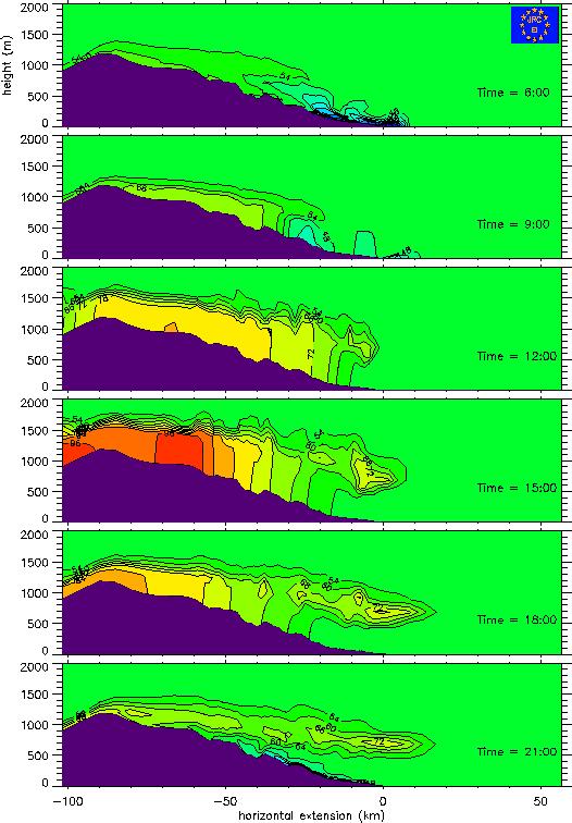
2 Within the synoptic meteorological patterns, mesoscale patterns develop, with marked diurnal cycles and spatial scales of tens of kilometres. They are induced by sea-land and upslope-downslope winds, and are typical for Southern Europe with its complex coastal and orographic features and high solar radiation. The concepts downwind and upwind of sources loose their straightforward meaning and must be reconsidered in the light of these mesoscale recirculations. Computational results The computational results are obtained using the EI/EMTF integrated modelling system consisting of a meteorological model, a tracer transport code and one of the two gasphase chemistry modules LCC or RACM. The combined meteorological/transport model is the Topographic Vorticity Mesoscale model TVM (cf. Schayes et al, 1996, J. of Appl. Meteorology, 35, ). The model LCC (cf. Lurman, Carter, Coyner, 1987, EPA report No. 600/3-87/014A) simulates 106 chemical gas-phase reactions for 44 chemical species. The Regional Atmospheric Chemistry Mechanism RACM (cf. Stockwell et al, 1997, J. Geophys. Res. 102, D22, ) treats 237 reaction equations for 65 species. Figure 1 The computational domain and topography employed in the simulations for the Burriana site are shown in Figure 1. In order to increase the accuracy in the region between Burriana and Valbona, a non-uniform mesh has been chosen. Its resolution ranges from 1 by 1 km2 in a rectangle of 42 km west-east and 35 km south-north extent between Burriana and Valbona to progressively reach a 5 by 5 km2 resolution at the edges of the domain. The outer perimeter in Figure 1 delimits the total area in which the meteorological model is run. The domain is covered by a (72 x 58) grid system. The same horizontal domain is used for both the meteorology and the photochemistry calculations. In the vertical direction a terrain-following σ-coordinate system is defined. For meteorological computations, 25 levels were selected reaching an altitude of approximately 12 km with a non-uniform spacing ranging from 30 m to 1 km while for chemistry computations only the 14 lowest layers were used. The contour lines in Figure 1 indicate terrain elevation at intervals of 100 m. Figure 2 Here the diurnal results for the formation and depletion of ozone of the 3-dimensional simulations are shown in a vertical plane perpendicular to the coast intersecting the sites of Burriana and Cirat. During the night the formation of the drainage flow (the accumulation of a stable air mass at the bottom of the valleys and over the coastal plains) generates an offshore flow. In the morning and due to the increasing temperature of the land, the draining air mass becomes blocked at some distance from the coast. Due to further heating of the land, the sea-breeze is fully developed by mid-afternoon. The onshore and inland air flow continues into the evening hours, with wind speeds decreasing and becoming stagnant by midnight. Concerning the chemistry the computational results show the following: At night, when photochemistry is not active, anthropogenic NO emissions near the coast lead to a strong depletion of O3 which lowers its concentration to near-zero values. Under the
3 influence of the land breeze this low-ozone air mass is transported over the sea offshore, where further depletion of ozone takes place. Note that the strong atmospheric stability at these times creates a highly variable vertical profile for ozone concentrations near the shore. Values at surface are close to zero while at a few hundred meters altitude, they reach approximately 60 ppb. From the early morning on the calculations show the entrance of the sea breeze taking with it the air mass from the sea. Due to the influence of the photochemistry, the emissions of NOx and anthropogenic VOCs, a production of ozone takes place. These ozone concentrations can reach relatively high values in land (up to 120 ppb in Cirat). As a consequence of the reverse flow on top of the sea-breeze, this ozone-rich air mass is transported to higher levels, called the reservoir layer. Figure 3 This figure shows the evolution of the ozone concentration field (simulated with TVM/RACM) for six different instants of time of June 12 th. The corresponding TVM wind directions are not shown in detail but only schematically by arrows. At 04:00 LST, the nocturnal cooling of the inland ground surfaces has led to the formation of down-slope flows on each individual hill or mountain within the domain. These slope flows have progressively filled valleys with cold air and the resulting pressure gradient has led to the development of valley flows. By the same effect of differential cooling between water and inland surfaces, a land breeze is at that time fully developed and directly influences coastal locations such as Burriana, Sagunto or Castellon. The meteorology (temperature, wind speed and direction) is generally well reproduced for all stations except at Cirat for which the underestimation in wind speed is probably due to the lack of resolution in this area. At coastal sites, the high NOx emissions (VOC limited regime) lead to very low ozone values. At Onda, which is located a few kilometers inland, the ozone levels much depend on the wind direction and slight changes in the latter can produce low ozone values. Hence, the ozone night-time evolution at this station exhibits a very chaotic behaviour. For more inland stations like Cirat or Valbona, night time ozone values never drop below 20 or 30 ppb. These values are lower than the background value (50 ppb) and indicate some ozone depletion which is either due to local emissions or to transport of polluted air from the Western part of the domain. At sunrise, land surface starts to warm up and pressure gradients reverse. Up-slope flows directly form simultaneously with the onset of the sea-breeze. As a consequence, the flow is directed onshore over the whole domain at approximately the same time. This onshore flow carries with it the night-time pollutants which starts entering the classical chain of photochemical reactions. These reactions are at that time very efficient since over the sea, the mixing layer is very limited. When these pollutants reach the coast, a sudden rise in ozone concentrations is observed. This is the case at coastal stations like Burriana where after the passage of the breeze front, ozone concentrations drop down. After the passage of the breeze front, ozone values generally do not exceed the background value since large emissions are continuously active (persistence of the VOC limited regime). At mid-afternoon, while photo-chemistry is acting on the newly emitted compounds, the cloud of maximum ozone concentrations corresponding to the transformation of nighttime emissions is pushed further inland to the North-West. Locations such as Cirat
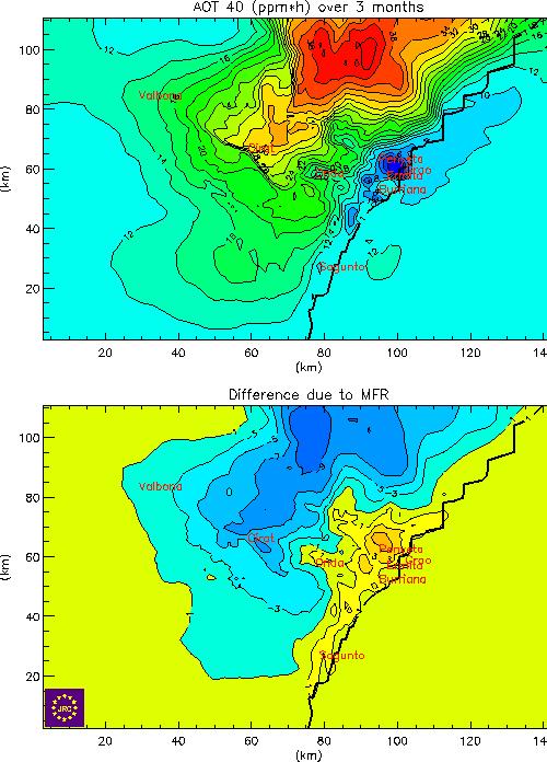
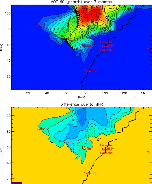
4 experience a sharp rise in ozone concentration at 16:00 LST, whereas at Valbona the sea-breeze ozone peak only arrives at 18:00 LST. At this location, two clear peaks are observed, the first one probably due to local photochemistry, while the second is the result of the sea-breeze arrival. After sunset, photochemical reactions are inhibited and emissions are again constrained in a very shallow layer that favours ozone destruction. This is the case at nearly every inland station. At Cirat, the day-time peak is relatively well reproduced. Figure 4 In this figure we show a NOx-AVOC emission reduction isopleth for AOT40 and AOT60 values for Burriana and Cirat. On the horizontal axis the NOx emissions are given as a fraction of the base-case; the vertical axis gives the fraction of the base-case AVOC emissions. The point (1.,1.) corresponds to the base-case emission inventory. The point REF corresponds to the Reference-Reduction (i.e. 23% NOx, 25% AVOC reduction); the point MFR to the Most-Feasible-Reduction (i.e. 59% NOx, 53% AVOC reduction). The diurnal values for AOT40 and AOT60 (in units: ppm.hr) are multiplied by 90 to correspond with the 3 months period in the definition of AOT40. AOT40 values for Burriana range from approximately 7.0 to The AOT60 value for Burriana is equal to zero, because the ozone levels never exceed 60 ppb. In Cirat the AOT60 ranges from 12.5 to We conclude that at Burriana the REF and the MFR reductions do increase the AOT40 values. In Cirat the REF and MFR reductions have almost no influence on the values of AOT40, and do decrease the values of AOT60. We note that the AOT values may be overestimated due to the multiplication by 90 of the diurnal values. Figure 5 The top figure shows the AOT40 values in the 3-dimensional case at ground level. The bottom figure depicts the difference of the MFR reduction case with the base-case. Absolute values range from 10 ppm.hr (blue area) to 40 ppm.hr (red area). The impact of the MFR reduction is positive but small in the yellow part (increasing values for AOT40), and negative (i.e. lower values of AOT40) in the blue part of the picture. Figure 6 Same as for Figure 5, but for AOT60 values. AOT absolute values are 0. in the purple part, and take maximum values of 20 ppm.hr in the red part. The impact of the MFR reduction is 0. in the yellow area, and negative (decreasing AOT60) in the blue area.

5 Figure 1
6 Figure 2
7 Figure 3

8 Figure 4
9 Figure 5
10 Figure 6
ABSTRACT INTRODUCTION
 Numerical investigation of the formation of elevated pollution layers over the Los Angeles air basin Rong Lu, R.P. Turco Department of Atmospheric Sciences, University of California, Los Angeles, 405 Hilgard
10.6 The Dynamics of Drainage Flows Developed on a Low Angle Slope in a Large Valley Sharon Zhong 1 and C. David Whiteman 2
 10.6 The Dynamics of Drainage Flows Developed on a Low Angle Slope in a Large Valley Sharon Zhong 1 and C. David Whiteman 2 1Department of Geosciences, University of Houston, Houston, TX 2Pacific Northwest
Atmospheric Dispersion, Transport and Deposition. Dispersion. Wind Speed. EOH 468 Spring 2008 Dr. Peter Bellin, CIH, Ph.D.
 Atmospheric Dispersion, Transport and Deposition EOH 468 Spring 2008 Dr. Peter Bellin, CIH, Ph.D. Dispersion Atmospheric process affect dilution. Wind speed and lapse rate impact on emissions. Planetary
Impact of Sea Breeze Fronts on Urban Heat Island & Air Quality in Texas
 Impact of Sea Breeze Fronts on Urban Heat Island & Air Quality in Texas Xiao-Ming Hu Center for Analysis and Prediction of Storms, School of Meteorology University of Oklahoma July 14, 2015 at LanZhou
Photochemical modelling of the Barcelona area under weak pressure synoptic summer conditions
 Photochemical modelling of the Barcelona area under weak pressure synoptic summer conditions I. Toll and J. M. Baldasano Laboratory of Environmental Modelling, Department of Engineering Projects, Universitat
Sea and Land Breezes METR 4433, Mesoscale Meteorology Spring 2006 (some of the material in this section came from ZMAG)
") Sea and Land Breezes METR 4433, Mesoscale Meteorology Spring 2006 (some of the material in this section came from ZMAG) 1 Definitions: The sea breeze is a local, thermally direct circulation arising from
Sea and Land Breezes METR 4433, Mesoscale Meteorology Spring 2006 (some of the material in this section came from ZMAG) 1 Definitions: The sea breeze is a local, thermally direct circulation arising from
Characterization of Boundary-Layer Meteorology During DISCOVER-AQ
 Characterization of Boundary-Layer Meteorology During DISCOVER-AQ Daniel M. Alrick and Clinton P. MacDonald Sonoma Technology, Inc. Gary A. Morris St. Edward s University for Texas Air Quality Research
MET 200 Lecture 11 Local Winds. Last Lecture: Forces. Review of Forces. Balance of Forces
 MET 200 Lecture 11 Local Winds Last Lecture: Forces Scales of Motion Eddies Sea Breeze Mountain-Valley Circulations Chinook - Snow Eater Drainage Wind - Katabatic Wind 1 2 Review of Forces 1. Pressure
6.28 PREDICTION OF FOG EPISODES AT THE AIRPORT OF MADRID- BARAJAS USING DIFFERENT MODELING APPROACHES
 6.28 PREDICTION OF FOG EPISODES AT THE AIRPORT OF MADRID- BARAJAS USING DIFFERENT MODELING APPROACHES Cecilia Soriano 1, Darío Cano 2, Enric Terradellas 3 and Bill Physick 4 1 Universitat Politècnica de
Local Winds. Please read Ahrens Chapter 10
 Local Winds Please read Ahrens Chapter 10 Scales of Motion Microscale: meters Turbulent eddies Formed by mechanical disturbance or convection Lifetimes of minutes Mesoscale: km s to 100 s of km s Local
Influence of Heat Transport by Sea Breezes on Inland Temperature in the Osaka Area
 Academic Article Journal of Heat Island Institute International Vol. 9-2 (2) Influence of Heat Transport by Sea Breezes on Inland Temperature in the Osaka Area Atsumasa Yoshida* Junichi Yashiro* Xinbo
ASSESSMENT OF SEA BREEZE CHARACTERISTICS FROM SODAR ECHOGRAMS
 ASSESSMENT OF SEA BREEZE CHARACTERISTICS FROM SODAR ECHOGRAMS SUNEETHA RANI. JUPUDI Prof. M. PURNACHANDRA RAO Department of Physics, Andhra University, Visakhapatnam, India. ABSTRACT The SODAR echograms
Vertical Motion and Atmospheric Stability
 Lesson 4 Vertical Motion and Atmospheric Stability This lesson describes the vertical structure of the atmosphere, atmospheric stability and the corresponding vertical motion. Adiabatic diagrams are introduced
An Analysis of the South Florida Sea Breeze Circulation: An Idealized Study
 An Analysis of the South Florida Sea Breeze Circulation: An Idealized Study John Cangialosi University of Miami/RSMAS Abstract This experiment is an idealized study (removal of mean large scale flow) to
1 INTRODUCTION. Figure 2: Synoptical situation at the beginning of the simulation: 5th January 1999 at 12UTC.
 2.2 NOCTURNAL CIRCULATIONS UNDER WEAK PRESSURE GRADIENTS IN THE ISLAND OF MALLORCA J. Cuxart and M.A. Jiménez Universitat de les Illes Balears, Spain 1 INTRODUCTION To study the local nocturnal circulations
Idealized WRF model sensitivity simulations of sea breeze types and their effects on offshore windfields: Supplementary material
 Idealized WRF model sensitivity simulations of sea breeze types and their effects on offshore windfields: Supplementary material Authors: C. J. Steele, S. R. Dorling, R. von Glasow and J. Bacon Synoptic
2. THE NEW ENGLAND AIR QUALITY STUDY
 P2.4 NEW ENGLAND COASTAL AIR POLLUTION DISPERSION MODELING Michael Tjernström * and Mark Žagar Stockholm University, Stockholm, Sweden Wayne Angevine CIRES, University of Colorado, and NOAA Aeronomy Laboratory,
Wind Power. Kevin Clifford METR 112 April 19, 2011
 Wind Power Kevin Clifford METR 112 April 19, 2011 Outline Introduction Wind Turbines Determining Wind Power Output The Price of Wind Power Wind Power Availability across the World and US California Wind
Goals for today: continuing Ch 8: Atmospheric Circulation and Pressure Distributions. 26 Oct., 2011
 Goals for today: 26 Oct., 2011 continuing Ch 8: Atmospheric Circulation and Pressure Distributions Examples of synoptic scale and mesoscale circulation systems that are driven by geographic diversity in
INTRODUCTION * Corresponding author address: Michael Tjernström, Stockholm University, Department of Meteorology, SE-
 4.12 NEW ENGLAND COASTAL BOUNDARY LAYER MODELING Mark Žagar and Michael Tjernström * Stockholm University, Stockholm, Sweden Wayne Angevine CIRES, University of Colorado, and NOAA Aeronomy Laboratory,
Mass Budget Simulations in the Area of the City of Augsburg. A contribution to subproject GLOREAM. K Nester, F. Fiedler and H-J Panitz
 Mass Budget Simulations in the Area of the City of Augsburg A contribution to subproject GLOREAM K Nester, F. Fiedler and H-J Panitz Institut fiir Meteorologie und Klimaforschung, Forschungszentrum Karlsruhe/Universitat
Chapter 2. Turbulence and the Planetary Boundary Layer
 Chapter 2. Turbulence and the Planetary Boundary Layer In the chapter we will first have a qualitative overview of the PBL then learn the concept of Reynolds averaging and derive the Reynolds averaged
Figure 1. Modeling domains used in WRF-ARW
 SIMULATION OF TRANSPORT AND DISPERSION OF POLLUTANTS FROM ELEVATED POINT SOURCES IN MISSISSIPPI GULF COAST USING A MESOSCALE ATMOSPHERIC DISPERSION MODELING SYSTEM Venkata Srinivas Challa, Jayakumar Indracanti,
The total precipitation (P) is determined by the average rainfall rate (R) and the duration (D),
 is determined by the average rainfall rate (R) and the duration (D),") Orographic precipitation Common ingredients of heavy orographic precipitation The total precipitation (P) is determined by the average rainfall rate (R) and the duration (D), P = RD. (1) The rainfall rate
Orographic precipitation Common ingredients of heavy orographic precipitation The total precipitation (P) is determined by the average rainfall rate (R) and the duration (D), P = RD. (1) The rainfall rate
August 1990 H. Kondo 435. A Numerical Experiment on the Interaction between Sea Breeze and
 August 1990 H. Kondo 435 A Numerical Experiment on the Interaction between Sea Breeze and Valley Wind to Generate the so-called "Extended Sea Breeze" By Hiroaki Kondo National Research Institute for Pollution
Wind: Small-scale and Local Systems
 Wind: Small-scale and Local Systems Scales of Atmospheric Motion Atmospheric motions/phenomena occur on many diverse spatial and temporal scales. Weather forecasters tend to focus on Mesoscale and synoptic
Stormy Weather. tropopause. z i
 Stormy Weather tropopause z i z x High Low Stormy Weather Tropopausez Venting by thunderstorms y Venting by fronts x Stormy Weather Height, z tropopause clouds clouds z i BL n cold air warm air z i BL
Emission Inventory Evaluation Using DISCOVER-AQ Aircraft Data
 Emission Inventory Evaluation Using DISCOVER-AQ Aircraft Data Gary McGaughey, David Allen (PI) and Elena McDonald-Buller (co-pi) Center for Energy and Environmental Resources The University of Texas at
Meteorology. Circle the letter that corresponds to the correct answer
 Chapter 4 Worksheet 2 Meteorology Name: Circle the letter that corresponds to the correct answer 1) If the air temperature remains constant, evaporating water into the air will the dew point and the relative
Mountain Forced Flows
 Mountain Forced Flows Jeremy A. Gibbs University of Oklahoma gibbz@ou.edu February 3, 2015 1 / 45 Overview Orographic Precipitation Common Ingredients of Heavy Orographic Precipitation Formation and Enhancement
LOCAL WINDS. Prof. Stephan De Wekker Department of Env. Sciences Guest lecture EVSC 1300
 LOCAL WINDS Prof. Stephan De Wekker (dewekker@virginia.edu) Department of Env. Sciences Guest lecture EVSC 1300 SEA BREEZE 980 mb 990 mb 1000 mb LAND BREEZE The convergence of two lake breezes and
2.4. Applications of Boundary Layer Meteorology
 2.4. Applications of Boundary Layer Meteorology 2.4.1. Temporal Evolution & Prediction of the PBL Earlier, we saw the following figure showing the diurnal evolution of PBL. With a typical diurnal cycle,
Impact of sea breeze air masses laden with ozone on inland surface ozone concentrations: A case study of the northern coast of Taiwan
 JOURNAL OF GEOPHYSICAL RESEARCH, VOL. 112,, doi:10.1029/2006jd008123, 2007 Impact of sea breeze air masses laden with ozone on inland surface ozone concentrations: A case study of the northern coast of
PGF. Pressure Gradient. Wind is horizontal movement of the air or other word air in motion. Forces affecting winds 2/14/2017
 Winds Wind is horizontal movement of the air or other word air in motion. Forces affecting winds 1. Pressure gradient force a. High pressure flows to low pressure b. Pressure gradient = difference in pressure
Meteorology. Circle the letter that corresponds to the correct answer
 Chapter 4 Worksheet 3 Meteorology Name: Circle the letter that corresponds to the correct answer 1) Natural convection and turbulence are most likely to occur when: a) temperature decreases rapidly with
Chapter. Air Pressure and Wind
 Chapter Air Pressure and Wind 19.1 Understanding Air Pressure Air Pressure Defined Air pressure is the pressure exerted by the weight of air. 19.1 Understanding Air Pressure Air Pressure Defined Air pressure
CEE 452/652. Week 3, Lecture 1 Mass emission rate, Atmospheric Stability. Dr. Dave DuBois Division of Atmospheric Sciences, Desert Research Institute
 CEE 452/652 Week 3, Lecture 1 Mass emission rate, Atmospheric Stability Dr. Dave DuBois Division of Atmospheric Sciences, Desert Research Institute Today s topics Review homework Review quiz Mass emission
1.5 THE LAND BREEZE CHARACTERISTICS IN ISRAEL DURING THE SUMMER BY THE MM5 MODEL
 1. THE LAND BREEZE CHARACTERISTICS IN ISRAEL DURING THE SUMMER BY THE MM MODEL S. Berkovic and Y. Feliks Department of Mathematics, Israel Institute for Biological Research P.O.B 19, Ness-Ziona, Israel
Measurements of atmospheric CO 2 concentrations along a transect
 Measurements of atmospheric CO 2 concentrations along a transect Introduction Catalonia is situated in the north east of Spain, on the Mediterranean coastline. It is characterized by three main morphological
along the western shore of Lake Michigan found that high concentrations of ozone observed at ground-level were associated with southeasterly or onshor
 Chapter 5 Lake Breeze and Oxidants Over South-Eastern Ontario Due to the thermal inertia of large bodies of water, lakes (or oceans) warm and cool considerably slower than the adjacent land surfaces On
EVE 402/502 Air Pollution Generation and Control. Introduction. Intro, cont d 9/18/2015. Chapter #3 Meteorology
 EVE 402/502 Air Pollution Generation and Control Chapter #3 Meteorology Introduction Meteorology is the study and forecasting of weather changes resulting from large-scale atmospheric circulation Characteristics
1.6 HIGH RESOLUTION SIMULATIONS OF THE ISLAND-INDUCED CIRCULATIONS FOR THE ISLAND OF HAWAII DURING HaRP. Yang Yang and Yi-Leng Chen*
 1.6 HIGH RESOLUTION SIMULATIONS OF THE ISLAND-INDUCED CIRCULATIONS FOR THE ISLAND OF HAWAII DURING HaRP Yang Yang and Yi-Leng Chen* Department of Meteorology University of Hawaii at Manoa Honolulu, Hawaii
Conditions for Offshore Wind Energy Use
 Carl von Ossietzky Universität Oldenburg Institute of Physics Energy Meteorology Group Detlev Heinemann Conditions for Offshore Wind Energy Use Detlev Heinemann ForWind Carl von Ossietzky Universität Oldenburg
Thermally-forced Circulations. Presented by: Daran Rife NCAR RAL 26 Jul 2005
 Thermally-forced Circulations Presented by: Daran Rife NCAR RAL 26 Jul 2005 Thermally-driven Winds: Some Basic Concepts A class of mesoscale circulations driven by horizontal gradients in surface heating
Air Pressure and Wind
 Air Pressure and Wind 19.1 Understanding Air Pressure Air Pressure Defined Air pressure is the pressure exerted by the weight of air. Air pressure is exerted in all directions down, up, and sideways. The
ESCONDIDO FIRE DEPT TRAINING MANUAL Section Engine Module Page 1 of 15 Wildland Fire Weather Revised
 Engine Module Page 1 of 15 WEATHER Weather is the most critical element of fire behavior. Weather is also the most unpredictable element. Firefighting personnel should be knowledgeable in local weather
DUE TO EXTERNAL FORCES
 17B.6 DNS ON GROWTH OF A VERTICAL VORTEX IN CONVECTION DUE TO EXTERNAL FORCES Ryota Iijima* and Tetsuro Tamura Tokyo Institute of Technology, Yokohama, Japan 1. INTRODUCTION Various types of vertical vortices,
The dynamics of heat lows over flat terrain
 The dynamics of heat lows over flat terrain Roger K. Smith, Thomas Spengler presented by Julia Palamarchuk, Ukraine, Odessa Split Workshop in Atmospheric Physics and Oceanography, May 22-30, Split, Croatia
Santa Ana Winds. Surface weather map showing typical Santa Ana conditions.
 Santa Ana Winds Surface weather map showing typical Santa Ana conditions. High Desert Elevation ~1500-2000 ft Santa Ana Winds ~1500 meters 0 meters Santa Ana Winds ~875 mb ~1500 meters ~875 mb Horizontal
Land use changes and their impacts on extreme events. By Millán M. Millán
 Land use changes and their impacts on extreme events By Millán M. Millán Conference: Land as a Resource, Brussels 19 June 2014 Atlantic Fronts 20% Decreasing Summer Storms 15% Decreasing Gone Mediterranean
Boundary layer meso-scale flows. Hannu Savijärvi University of Helsinki
 Boundary layer meso-scale flows Hannu Savijärvi University of Helsinki Contents Mechanical channeling Thermal heat islands Slope winds Sea breezes Thermal channeling on a sea gulf spring, early summer
Abstract. 1 Introduction
 Features of the Athens Basin wind flow in view of recent experimental work D.N. Asimakopoulos,* C.G. Helmis,* K.H. Papadopoulos,* J.A. Kalogiros,* A.T. Soilemes," M. Petrakis^ "Department ofapplied Physics,
A case study of boundary layer ventilation by convection and coastal processes
 Click Here for Full Article JOURNAL OF GEOPHYSICAL RESEARCH, VOL. 112,, doi:10.1029/2006jd007984, 2007 A case study of boundary layer ventilation by convection and coastal processes H. F. Dacre, 1 S. L.
IMPACTS OF COASTAL PROTECTION STRATEGIES ON THE COASTS OF CRETE: NUMERICAL EXPERIMENTS
 IMPACTS OF COASTAL PROTECTION STRATEGIES ON THE COASTS OF CRETE: NUMERICAL EXPERIMENTS Tsanis, I.K., Saied, U.M., Valavanis V. Department of Environmental Engineering, Technical University of Crete, Chania,
Mesoscale Meteorology
 Mesoscale Meteorology METR 4433 Spring 2015 3.4 Drylines The dryline is a mesoscale phenomena whose development and evaluation is strongly linked to the PBL. In this section, we will consider its general
UTLS Asian monsoon anticyclone
 UTLS Asian monsoon anticyclone Dynamics and transport in the monsoon anticyclone Chemical variability linked to the monsoon Instability and eddy shedding; PV diagnostics Transport to stratosphere Eruption
Meteorology I Pre test for the Second Examination
 Meteorology I Pre test for the Second Examination MULTIPLE CHOICE 1. A primary reason why land areas warm up more rapidly than water areas is that a) on land, all solar energy is absorbed in a shallow
Small- and large-scale circulation
 The Earth System - Atmosphere II Small- and large-scale circulation Atmospheric Circulation 1. Global atmospheric circulation can be thought of as a series of deep rivers that encircle the planet. 2. Imbedded
1. Large-scale temperature inversions.
 Lecture 18. Local and regional pollution issues: plumes of pollution. Objectives: 1. Large-scale temperature inversions. 2. Plumes of pollution. Readings: Turco: p.128-135; Brimblecombe: p.130-138 1. Large-scale
A Numerical Study of the Thermally Driven Plain-to-Basin Wind over Idealized Basin Topographies
 606 JOURNAL OF APPLIED METEOROLOGY A Numerical Study of the Thermally Driven Plain-to-Basin Wind over Idealized Basin Topographies STEPHAN F. J. DE WEKKER,* SHIYUAN ZHONG, JEROME D. FAST, AND C. DAVID
Abstract. 1 Introduction
 On the atmospheric stability in the Athens Basin M. Petrakis,* P. Kassomenos,* S. Lykoudis,* V. Synodinou^ "National Observatory ofathens, Institute of Meteorology and Physics of the Atmospheric Environment,
STUDY OF LOCAL WINDS IN MOUNTAINOUS COASTAL AREAS BY MULTI- SENSOR SATELLITE DATA
 STUDY OF LOCAL WINDS IN MOUNTAINOUS COASTAL AREAS BY MULTI- SENSOR SATELLITE DATA Werner Alpers Institute of Oceanography, University of Hamburg, Bundesstrasse 53, D-20146 Hamburg, Germany E-mail: alpers@ifm.uni-hamburg.de
Meteorology 2/6/2017. Wind, and its Interaction with Particle Plumes. Variation of wind speed with elevation. Variation of wind speed during the day
 Meteorology The effect of wind, weather, and temperature conditions on the behavior of particle plumes Wind, and its Interaction with Particle Plumes Variation of wind speed with elevation Variation of
Use of Equivalent Building Dimensions (EBD) to Characterize Upwind Terrain Wake Effects for AERMOD
 to Characterize Upwind Terrain Wake Effects for AERMOD") Use of Equivalent Building Dimensions (EBD) to Characterize Upwind Terrain Wake Effects for AERMOD Paper # 425 100 th Annual Meeting of the Air & Waste Management Association June 2007 Ronald Petersen
Use of Equivalent Building Dimensions (EBD) to Characterize Upwind Terrain Wake Effects for AERMOD Paper # 425 100 th Annual Meeting of the Air & Waste Management Association June 2007 Ronald Petersen
Wind: Small Scale and Local Systems Chapter 9 Part 1
 Wind: Small Scale and Local Systems Chapter 9 Part 1 Atmospheric scales of motion Scales of atmospheric circulations range from meters or less to thousands of kilometers- millions of meters Time scales
18.1 Understanding Air Pressure 18.1 Understanding Air Pressure Air Pressure Defined Measuring Air Pressure Air pressure barometer
 18.1 Understanding Air Pressure 18.1 Understanding Air Pressure Air Pressure Defined Air pressure is the pressure exerted by the weight of air. Air pressure is exerted in all directions down, up, and sideways.
DEPARTMENT OF ENVIRONMENTAL AFFAIRS AND TOURISM. Environmental Quality and Protection. Chief Directorate: Air Quality Management & Climate Change
 DEPARTMENT OF ENVIRONMENTAL AFFAIRS AND TOURISM Environmental Quality and Protection Chief Directorate: Air Quality Management & Climate Change NATIONAL AIR QUALITY MANAGEMENT PROGRAMME PHASE II TRANSITION
Scott Denning CSU CMMAP 1
 Thermodynamics, Buoyancy, and Vertical Motion Temperature, Pressure, and Density Buoyancy and Static Stability Adiabatic Lapse Rates Dry and Moist Convective Motions Present Atmospheric Composition What
Atmospheric & Ocean Circulation-
 Atmospheric & Ocean Circulation- Overview: Atmosphere & Climate Atmospheric layers Heating at different latitudes Atmospheric convection cells (Hadley, Ferrel, Polar) Coriolis Force Generation of winds
A Numerical Study of Thermal Effects on Flow and Pollutant Dispersion in Urban Street Canyons
 VOLUME 38 JOURNAL OF APPLIED METEOROLOGY SEPTEMBER 1999 A Numerical Study of Thermal Effects on Flow and Pollutant Dispersion in Urban Street Canyons JAE-JIN KIM AND JONG-JIN BAIK Department of Environmental
Numerical Approach on the Mechanism of Precipitation-Topography Relationship in Mountainous Complex Terrain
 Numerical Approach on the Mechanism of Precipitation-Topography Relationship in Mountainous Complex Terrain Yoshiharu, S. 1, S. Miyata 2, E. Nakakita 3 and M. Hasebe 4 1 Faculty of Engineering, Utsunomiya
The dryline is a mesoscale phenomena whose development and evaluation is strongly linked to the PBL.
 2.2. Development and Evolution of Drylines The dryline is a mesoscale phenomena whose development and evaluation is strongly linked to the PBL. Text books containing sections on dryline: The Dry Line.
Atmospheric & Ocean Circulation- I
 Atmospheric & Ocean Circulation- I First: need to understand basic Earth s Energy Balance 1) Incoming radiation 2) Albedo (reflectivity) 3) Blackbody Radiation Atm/ Ocean movement ultimately derives from
Flow Visualisation Studies - I
 Note DAPPLE - EnFlo xx May, 2004 Flow Visualisation Studies - I Alan Robins, Hong Cheng, Paul Hayden, Tom Lawton EnFlo, Surrey This note presents and discusses some preliminary flow visualisation studies
Currents measurements in the coast of Montevideo, Uruguay
 Currents measurements in the coast of Montevideo, Uruguay M. Fossati, D. Bellón, E. Lorenzo & I. Piedra-Cueva Fluid Mechanics and Environmental Engineering Institute (IMFIA), School of Engineering, Research
Observations and Modeling of Coupled Ocean-Atmosphere Interaction over the California Current System
 Observations and Modeling of Coupled Ocean-Atmosphere Interaction over the California Current System Cape Blanco Dudley Chelton 1, Xin Jin 2, Jim McWilliams 2 & Tracy Haack 3 1 Oregon State University
Forest Winds in Complex Terrain
 Forest Winds in Complex Terrain Ilda Albuquerque 1 Contents Project Description Motivation Forest Complex Terrain Forested Complex Terrain 2 Project Description WAUDIT (Wind Resource Assessment Audit and
Pollutant transport in coastal areas with and without background wind
 Ann. Geophysicae 15, 476±486 (1997) Ó EGS±Springer-Verlag 1997 Pollutant transport in coastal areas with and without background wind J. Camps 1, J. Massons 1, M. R. Soler 2, E. C. Nickerson 3 1 Applied
Measurement and simulation of the flow field around a triangular lattice meteorological mast
 Measurement and simulation of the flow field around a triangular lattice meteorological mast Matthew Stickland 1, Thomas Scanlon 1, Sylvie Fabre 1, Andrew Oldroyd 2 and Detlef Kindler 3 1. Department of
Local nocturnal circulations in the island of Majorca: mesoscale modelling and verification
 Tethys, 3, 67 73, 2006 www.tethys.cat ISSN-1139-3394 DOI:10.3369/tethys.2006.3.09 Journal edited by ACAM (Associació Catalana de Meteorologia) Local nocturnal circulations in the island of Majorca: mesoscale
Scales of Atmospheric Motion
 Lecture 12 Local Wind Systems Scales of Atmospheric Motion Small turbulent eddies (swirls) A synoptic eddy 1 Coriolis Effect The larger the scale, the longer the life time. Wind shear and turbulent eddy
3.6 Magnetic surveys. Sampling Time variations Gradiometers Processing. Sampling
 3.6 Magnetic surveys Sampling Time variations Gradiometers Processing Sampling Magnetic surveys can be taken along profiles or, more often, on a grid. The data for a grid is usually taken with fairly frequent
Scales of Atmospheric Motion. The atmosphere features a wide range of circulation types, with a wide variety of different behaviors
 Scales of Atmospheric Motion The atmosphere features a wide range of circulation types, with a wide variety of different behaviors Typically, the best way to classify these circulations is according to:
The impacts of explicitly simulated gravity waves on large-scale circulation in the
 The impacts of explicitly simulated gravity waves on large-scale circulation in the Southern Hemisphere. Linda Mudoni Department of Geological and Atmospheric Sciences October 2003 Introduction In the
Seasonal Evaluation of Temperature Inversion
 Seasonal Evaluation of Temperature Inversion Kandil, H A 1, Kader M M. A 2, Moaty, A A. 2, Elhadidi, B 3, Sherif, A.O. 3 The seasonal evaluation of the temperature inversion over Cairo-Egypt is examined
MODELING INDIAN OCEAN CIRCULATION: BAY OF BENGAL FRESH PLUME AND ARABIAN SEA MINI WARM POOL
 MODELING INDIAN OCEAN CIRCULATION: BAY OF BENGAL FRESH PLUME AND ARABIAN SEA MINI WARM POOL P. N. Vinayachandran* 1 1, *2 and J. Kurian* * 1 Centre for Atmospheric and Oceanic Sciences, Indian Institute
Technical Brief - Wave Uprush Analysis Island Harbour Club, Gananoque, Ontario
 Technical Brief - Wave Uprush Analysis RIGGS ENGINEERING LTD. 1240 Commissioners Road West Suite 205 London, Ontario N6K 1C7 October 31, 2014 Table of Contents Section Page Table of Contents... i List
MET Lecture 8 Atmospheric Stability
 MET 4300 Lecture 8 Atmospheric Stability Stability Concept Stable: Ball returns to original position Neutral: Ball stays wherever it is placed Unstable: Displacement grows with time. Atmospheric Stability
Influence of rounding corners on unsteady flow and heat transfer around a square cylinder
 Influence of rounding corners on unsteady flow and heat transfer around a square cylinder S. K. Singh Deptt. of Mech. Engg., M. B. M. Engg. College / J. N. V. University, Jodhpur, Rajasthan, India Abstract
4/29/2011. Concept of Stability Lapse Rates Determine Stability and Stability Indices. Air pressure decreases with elevation.
 Chapter 6: Stability Concept of Stability Concept of Stability Lapse Rates Determine Stability and Stability Indices Air Parcel Expands as It Rises Air Parcel Expands As It Rises Air pressure decreases
Windcube FCR measurements
 Windcube FCR measurements Principles, performance and recommendations for use of the Flow Complexity Recognition (FCR) algorithm for the Windcube ground-based Lidar Summary: As with any remote sensor,
Modeled trend and future projection of surface ozone in East Asia
 1 November 16, 2011 Tripartite Workshop on Scientific Research of Photochemical Oxidant Modeled trend and future projection of surface ozone in East Asia Toshimasa Ohara National Institute for Environmental
Flow modelling hills complex terrain and other issues
 Flow modelling hills, complex terrain and other issues Modelling approaches sorted after complexity Rules of thumbs Codes and standards Linear model, 1 st order turbulence closure LINCOM/Wasp Reynolds-averaged
Winds and Ocean Circulations
 Winds and Ocean Circulations AT 351 Lab 5 February 20, 2008 Sea Surface Temperatures 1 Temperature Structure of the Ocean Ocean Currents 2 What causes ocean circulation? The direction of most ocean currents
11. WIND SYSTEMS A&B: Ch 8 (p )
") 1 11. WIND SYSTEMS A&B: Ch 8 (p 214-238) Concepts: I. Scale II. Differential heating III. Wind direction 1. Scales: Three major divisions Space Time Micro meters seconds - minutes Meso kilometers seconds
1 11. WIND SYSTEMS A&B: Ch 8 (p 214-238) Concepts: I. Scale II. Differential heating III. Wind direction 1. Scales: Three major divisions Space Time Micro meters seconds - minutes Meso kilometers seconds
Local Winds & Microclimates. Unit 2- Module 1
 Local Winds & Microclimates Unit 2- Module 1 Objectives Overview of local winds (sea & land breezes, valley winds) Overview of microclimates (valley, urban, woodland) Local Winds Local Winds Local winds
P2.25 SUMMER-TIME THERMAL WINDS OVER ICELAND: IMPACT OF TOPOGRAPHY. Bergen
 P2.25 SUMMER-TIME THERMAL WINDS OVER ICELAND: IMPACT OF TOPOGRAPHY Haraldur Ólafsson 1 and Hálfdán Ágústsson 2 1 University of Iceland, Bergen School of Meteorology, Geophysical Institute, University of
FORMULATION OF THE THERMAL INTERNAL BOUNDARY LAYER IN A MESOSCALE MODEL. and
 FORMULATON OF THE THERMAL NTERNAL BOUNDARY LAYER N A MESOSCALE MODEL W. L. PHYSCK, D. J. ABBS CSRO Division of Atmospheric Research, Private Bag No. 1, Mordialloc, Australia, 3195 and R. A. PELKE Dept.
A climatological study of the sea and land breezes in the Arabian Gulf region
 Click Here for Full Article JOURNAL OF GEOPHYSICAL RESEARCH, VOL. 113,, doi:10.1029/2007jd009710, 2008 A climatological study of the sea and land breezes in the Arabian Gulf region Rebecca E. Eager, 1,4
Cloud Development and Forms
 Chapter 6 Lecture Understanding Weather and Climate Seventh Edition Cloud Development and Forms Redina L. Herman Western Illinois University Mechanisms That Lift Air When air lifts, clouds develop and