Stormy Weather. tropopause. z i
|
|
|
- Dominick Page
- 5 years ago
- Views:
Transcription


1 Stormy Weather tropopause z i z x High Low
2 Stormy Weather Tropopausez Venting by thunderstorms y Venting by fronts x


3 Stormy Weather Height, z tropopause clouds clouds z i BL n cold air warm air z i BL frontal zone
4 The Atmospheric Boundary Layer Turbulence (9.1) The Surface Energy Balance (9.2) Vertical Structure (9.3) Evolution (9.4) Special Effects (9.5) The Boundary Layer in Context (9.6)
5 Diurnal Mountain Winds C. David Whiteman Meteorology 3000 Mountain Weather and Climate Spring 2005
6 The mountain wind system Four interacting wind systems are found over mountain terrain: Slope wind system (upslope and downslope winds) Along-valley wind system (up-valley and down-valley winds) Cross-valley wind system (from the cold to warm slope) Mountain-plain wind system (plain-mtn and mtn-plain winds) Because diurnal mountain winds are driven by horizontal temperature differences, the regular evolution of the winds in a given valley is closely tied to the thermal structure of the atmospheric boundary layer within the valley, which is characterized by a diurnal cycle of buildup and breakdown of a temperature inversion.

7 Thermally driven mountain wind systems Whiteman (2000)

8 Wind regimes Whiteman (2000)

9 Wind regimes Zardi and Whiteman (2012)
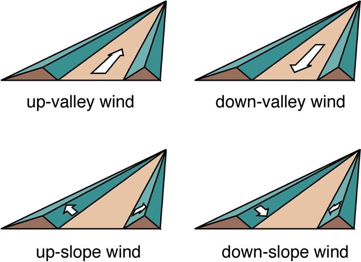
10 Wind Terminology
11 Wind system terminology valley wind = up-valley flow (daytime) mountain wind = down-valley flow (nighttime) anabatic flow = up-slope wind (daytime) katabatic flow = down-slope wind (nighttime) mountain-plain circulation drainage flows = down-slope and down-valley cross-valley flow = toward heated hillside anti-winds

12 Terrain Effects anabatic winds valley winds (a)

13 Terrain Effects katabatic winds mountain winds (b)
14 Slope winds Gravity or buoyancy currents following the dip of the underlying slope Caused by differences in temperature between air heated or cooled over the mountain slopes and air at the same altitude over the valley center Best-developed in clear, undisturbed weather Difficult to find in a pure form. Affected by along-valley wind system, weather (radiation budget, ambient flows), changing topography or surface cover

15 Slope flows Whiteman (2000)

16 Temperature inversion Whiteman (2000)

17 Thermal belt Geiger et al. (1995)
18 Valley Winds Air currents trying to equalize horizontal pressure gradients built up hydrostatically between valley and plain Caused by the stronger heating and cooling of the valley atmosphere as compared to the adjacent plain Best-developed in clear undisturbed weather

19 Along-valley flows Hawkes (1947)

20 Along-valley flows Zardi and Whiteman (2012)
21 Along-valley flows Zardi and Whiteman (2012)

22 Valley wind regimes Reiter et al. (1983)
23 Terrain Effects
24 Figure 3: Idealized flow over an isolated hill. Different stability conditions are defined by the values of the Froude number Fr=U/(NL), where U is the wind speed, N the Brunt-Vaisala frequency and L is the length scale of the hill (from Stull, 1988, p. 602, fig. 14.4). [Reprinted with kind permission from Kluwer Academic Publishers]
25
26
27 lenticular clouds lee wave region cap cloud roll clouds rotor
28


29
30 Terrain Effects
 a portion of a Föhn wall cloud is seen.")
31 Turbulent rotor cloud downwind (left-hand side of the photo) of the Sierra Nevada mountain range in the Owens Valley near Bishop, California. Downslope winds gather dust on the valley floor and serve as a tracer of the air rising suddenly into the cloud. Over the mountains themselves (upper right) a portion of a Föhn wall cloud is seen. (Photo taken by pilot Robert Symons, while flying a P-38 fighter. Photo courtesy of Morton G. Wurtele.)
32 8 7 (a) (b) z (km) (c) (d) z (km) x (km) x (km) 290 Figure Isentropes for the airflow in a two-layer atmosphere when the interface is fixed at 3000 m, and the mountain height is (a) 200, (b) 300, (c) 500, and (d) 800 m. (From Durran [1986b].)
33 8 (a) (b) z (km) (c) (d) z (km) x (km) x (km) 290 Figure Isentropes for the airflow in a two-layer atmosphere whenthemountainheightisfixedat500m,andthe interface is at (a) 1000 m, (b) 2500 m, (c) 3500 m, and (d) 4000 m. (From Durran [1986b].)
34 Terrain Effects

35

36 Terrain Effects
37 Terrain Effects
38 Terrain Effects
39 Terrain Effects 40 N (a) 30 N 20 N 10 N 40 N (b)
40 Terrain Effects 40 N (b) 30 N 20 N 10 N 40 N (c)
41 Terrain Effects 40 N (c) 30 N 20 N 10 N 120 W 110 W 100 W 90 W 80 W 70 W
42 Forest Canopy Effects (a) (b) (c) Height, z Night Day d Wind Speed Potential Temperature
43 Forest Canopy Effects (a) (b) (c) Night Day Height, z d log profile effective aerodynamic surface stable radiative cooling unstable radiative heating canopy downslope unstable stable Wind Speed Potential Temperature
44 Urban Effects North (a) Wind 26 C 24 C 22 C T = 20 C (b) Height, z Wind rural suburban Urban Boundary Layer urban suburban Urban Plume Rural Boundary Layer rural Horizontal Distance, x
45 Urban Effects More drag Drier surface Less vegetation Different albedo Albedo depends strongly on sun position Different heat capacity Greater emissions of pollutants and anthropogenic heat (b) Height, z Wind Urban Boundary Layer Urban Plume Rural Boundary Layer rural sub- urban suburban rural urban Horizontal Distance, x
46 Figure 2: Sketch of the urban boundary layer and urban plume for a windy day (a), and night (b) (from Stull, 1988, p. 611, fig ). [Reprinted with kind permission from Kluwer Academic Publishers]

47 Urban Effects
48 Urban Effects

49 Urban Effects surface radiating temperature

50 Urban Effects urban street canyon

51 Urban Effects urban street canyon

52 Urban Effects

53 Urban Effects
54 Wind Engineering
55 Wind Engineering
56 Wind Engineering

57 Wind Engineering


58 Wind Engineering Alan G. Davenport, with a model of New York City in 1980.


59 DUST STORMS IN THE EASTERN GREAT BASIN Maura Hahnenberger University of Utah Department of Atmospheric Sciences
 Leads to phenological changes in plants (Steltzer et al.")
60 Dust on Snow Reduces albedo of snow Increases snow melt rate causing Snow free day to be days earlier (Painter et al 2007) Dusty snow causes Peak runoff 3 weeks earlier at Lee s Ferry Reduces runoff by 5% (Painter et al. 2010) Leads to phenological changes in plants (Steltzer et al. 2009)
 Coarse particles: Deposited in bronchial passages leading to respiratory conditions Fine particles: Reach alveoli leading to cardiovascular")
61 Health Impacts of dust Increases in mortality: Spain (Perez et al. 2008) Increases in hospitalization for respiratory ailments: Texas (Grineski et al. 2011) Coarse particles: Deposited in bronchial passages leading to respiratory conditions Fine particles: Reach alveoli leading to cardiovascular events

62 Kellog & Griffin, 2006
63 Utah dust storms sometimes: Occur in March and April Occur during clear sky conditions Dense enough to totally obscure the sun and reduce visibility Accompanied by strong damaging winds Formed by winds from the south and southwest Followed by a wind shift to the northwest ending the dust storm Followed by muddy rain or snow washing out the dust Negatively impact human health and welfare Cause damage to crops and property
64 What wind speeds and directions are associated with the Dust Storms? Southwest winds Occasionally with northerly winds Usually speeds from m/s (22-45 mph)
65 When do we get South winds? L


66 The Hatu Winds Hatu is Utah spelled backward Warm winds coming from the south that occur ahead of an approaching storm. Pre-frontal dry winds These types of winds are a known producer of regional dust transport in arid regions. (Goudie 1978; Rivera Rivera et al. 2009; Strong et al. 2010)
67 When do Dust Storms occur in the Eastern Great Basin? In the afternoon. In the spring, with a much weaker peak in the fall.
68 Cyclo and Frontogenesis in the Great Basin Strong Frontal Passages Intermountain Cyclones SPRING SPRING SPRING AFTERNOON (Jeglum et al., 2010) (Shafer and Steenburgh, 2008)
69 Summary of Meteorology Strengthening cyclonic systems over the northern Great Basin are the main driver of dust events in this region With the dust event occurring in the pre frontal southerly wind environment Dust events occur mostly in spring and sometimes in fall Matches the climatology of strong fronts and cyclogenesis in this region Dust events have a diurnal pattern peaking in the afternoon Which is coincident with the maximum boundary layer depth Dust events have a clear impact on air quality in the SLC region Elevated particulate levels during most dust events and many days exceeding NAAQS for PM10 (Hahnenberger and Nicoll, 2012, Atmospheric Environment)
70 Summary of Source Areas Most dust plumes originate from: Dry Lake Beds (Playas) Disturbed areas Anthropogenic influence on most sources Drought helps drive dust production Human activities can directly alter dust production Must take landscape, soils, and climate into account (Hahnenberger and Nicoll, submitted, Geomorphology)
71
LOCAL WINDS. Prof. Stephan De Wekker Department of Env. Sciences Guest lecture EVSC 1300
 LOCAL WINDS Prof. Stephan De Wekker (dewekker@virginia.edu) Department of Env. Sciences Guest lecture EVSC 1300 SEA BREEZE 980 mb 990 mb 1000 mb LAND BREEZE The convergence of two lake breezes and
Thermally-forced Circulations. Presented by: Daran Rife NCAR RAL 26 Jul 2005
 Thermally-forced Circulations Presented by: Daran Rife NCAR RAL 26 Jul 2005 Thermally-driven Winds: Some Basic Concepts A class of mesoscale circulations driven by horizontal gradients in surface heating
Horizontal distance, x
 Height, z z i pping Free Atmosphere Inversion Boundary Layer Troposphere ~11 km ~2 km Earth Horizontal distance, x Adapted from Meteorology for Scientists and Engineers A Technical Companion Book to C.
Local Winds. Please read Ahrens Chapter 10
 Local Winds Please read Ahrens Chapter 10 Scales of Motion Microscale: meters Turbulent eddies Formed by mechanical disturbance or convection Lifetimes of minutes Mesoscale: km s to 100 s of km s Local
Chapter 2. Turbulence and the Planetary Boundary Layer
 Chapter 2. Turbulence and the Planetary Boundary Layer In the chapter we will first have a qualitative overview of the PBL then learn the concept of Reynolds averaging and derive the Reynolds averaged
18 Flight Hazards over High Ground
 18 Flight Hazards over High Ground meteorology 18.1 Mountain Effect on Fronts When a warm front passes a mountain range, the air, is lifted over the mountain and will strengthen the formation of cloud
Local Winds & Microclimates. Unit 2- Module 1
 Local Winds & Microclimates Unit 2- Module 1 Objectives Overview of local winds (sea & land breezes, valley winds) Overview of microclimates (valley, urban, woodland) Local Winds Local Winds Local winds
10.6 The Dynamics of Drainage Flows Developed on a Low Angle Slope in a Large Valley Sharon Zhong 1 and C. David Whiteman 2
 10.6 The Dynamics of Drainage Flows Developed on a Low Angle Slope in a Large Valley Sharon Zhong 1 and C. David Whiteman 2 1Department of Geosciences, University of Houston, Houston, TX 2Pacific Northwest
Wind: Small-scale and Local Systems
 Wind: Small-scale and Local Systems Scales of Atmospheric Motion Atmospheric motions/phenomena occur on many diverse spatial and temporal scales. Weather forecasters tend to focus on Mesoscale and synoptic
MET 200 Lecture 11 Local Winds. Last Lecture: Forces. Review of Forces. Balance of Forces
 MET 200 Lecture 11 Local Winds Last Lecture: Forces Scales of Motion Eddies Sea Breeze Mountain-Valley Circulations Chinook - Snow Eater Drainage Wind - Katabatic Wind 1 2 Review of Forces 1. Pressure
APPI PPG LECTURE 5: FURTHER METEOROLOGY
 LECTURE 5: FURTHER METEOROLOGY Introduction: This lecture covers Further Meteorology and aims to give you more of an understanding of advanced weather conditions and patterns. However Meteorology is a
Vertical Motion and Atmospheric Stability
 Lesson 4 Vertical Motion and Atmospheric Stability This lesson describes the vertical structure of the atmosphere, atmospheric stability and the corresponding vertical motion. Adiabatic diagrams are introduced
Over or Around? Kinetic Energy vs. Potential Energy. Critical Factors
 1 Terrain-forced vs. Thermally Driven Flows Thermally Driven Circulations produced by temperature contrasts that form within mountains or between mountains and surrounding plains Terrain-forced flows produced
Atmospheric Dispersion, Transport and Deposition. Dispersion. Wind Speed. EOH 468 Spring 2008 Dr. Peter Bellin, CIH, Ph.D.
 Atmospheric Dispersion, Transport and Deposition EOH 468 Spring 2008 Dr. Peter Bellin, CIH, Ph.D. Dispersion Atmospheric process affect dilution. Wind speed and lapse rate impact on emissions. Planetary
ESCONDIDO FIRE DEPT TRAINING MANUAL Section Engine Module Page 1 of 15 Wildland Fire Weather Revised
 Engine Module Page 1 of 15 WEATHER Weather is the most critical element of fire behavior. Weather is also the most unpredictable element. Firefighting personnel should be knowledgeable in local weather
Cold Air Damming. Introduction. Learning Objectives. Cold Air Damming. Cold Air Damming. Cold Air Damming 9/28/17. After this class you should
 Learning Objectives Atmos6250: Mountain Meteorology Jim Steenburgh Department of Atmospheric Sciences University of Utah Jim.Steenburgh@utah.edu After this class you should Recognize areas of North America
Meteorology I Pre test for the Second Examination
 Meteorology I Pre test for the Second Examination MULTIPLE CHOICE 1. A primary reason why land areas warm up more rapidly than water areas is that a) on land, all solar energy is absorbed in a shallow
Winds and Ocean Circulations
 Winds and Ocean Circulations AT 351 Lab 5 February 20, 2008 Sea Surface Temperatures 1 Temperature Structure of the Ocean Ocean Currents 2 What causes ocean circulation? The direction of most ocean currents
Meteorology. Circle the letter that corresponds to the correct answer
 Chapter 4 Worksheet 3 Meteorology Name: Circle the letter that corresponds to the correct answer 1) Natural convection and turbulence are most likely to occur when: a) temperature decreases rapidly with
Topoclimatic variations in temperature and winds as the basis for mountain refugia. C. David Whiteman University of Utah Salt Lake City
 Topoclimatic variations in temperature and winds as the basis for mountain refugia C. David Whiteman University of Utah Salt Lake City MtnClim 2014, Midway, UT, 15-18 Sept 2014 Definitions temperature
Lecture 13 March 24, 2010, Wednesday. Atmospheric Pressure & Wind: Part 4
 Lecture 13 March 24, 2010, Wednesday Atmospheric Pressure & Wind: Part 4 Synoptic scale winds Mesoscale winds Microscale winds Air-sea interactions The largest synoptic scale wind. Monsoon: Arabic for
Physical Geography. Physical Geography III of the United States and Canada. Formation of Great Lakes. Climates of North America. Definitions 2/21/2013
 Physical Geography III of the United States and Canada Ancient Glacial Lakes As the Ice Age ended, areas of North America beyond the terminal moraine were flooded with melt water Prof Anthony Grande AFG
The total precipitation (P) is determined by the average rainfall rate (R) and the duration (D),
 is determined by the average rainfall rate (R) and the duration (D),") Orographic precipitation Common ingredients of heavy orographic precipitation The total precipitation (P) is determined by the average rainfall rate (R) and the duration (D), P = RD. (1) The rainfall rate
Orographic precipitation Common ingredients of heavy orographic precipitation The total precipitation (P) is determined by the average rainfall rate (R) and the duration (D), P = RD. (1) The rainfall rate
ABSTRACT INTRODUCTION
 Numerical investigation of the formation of elevated pollution layers over the Los Angeles air basin Rong Lu, R.P. Turco Department of Atmospheric Sciences, University of California, Los Angeles, 405 Hilgard
EVE 402/502 Air Pollution Generation and Control. Introduction. Intro, cont d 9/18/2015. Chapter #3 Meteorology
 EVE 402/502 Air Pollution Generation and Control Chapter #3 Meteorology Introduction Meteorology is the study and forecasting of weather changes resulting from large-scale atmospheric circulation Characteristics
Civil Air Patrol Auxiliary of the United States Air Force
 Mountain Flying Qualification Course Civil Air Patrol Auxiliary of the United States Air Force Mountain Weather Slopes Most U.S. mountain ranges are oriented north-south, while the prevailing winds are
Mesoscale Meteorology
 Mesoscale Meteorology METR 4433 Spring 2015 3.4 Drylines The dryline is a mesoscale phenomena whose development and evaluation is strongly linked to the PBL. In this section, we will consider its general
Chapter 10, Part 1. Scales of Motion. Examples of Wind at Different Scales. Small Scale Winds
 Chapter 10, Part 1 Small Scale Winds Scales of Motion Wirls or eddies exist at all length scales in the atmosphere. Microscale (2m) Mesoscale (20km) Synoptic scale (2000km) Examples of Wind at Different
Downslope Wind Storms
 Downslope Wind Storms How does acceleration over the wing affect pressure field? Equation of Motion for frictionless flow: V t = l k α p+g If we assume a horizontally homogeneous, hydrostatic reference
DEPARTMENT OF ENVIRONMENTAL AFFAIRS AND TOURISM. Environmental Quality and Protection. Chief Directorate: Air Quality Management & Climate Change
 DEPARTMENT OF ENVIRONMENTAL AFFAIRS AND TOURISM Environmental Quality and Protection Chief Directorate: Air Quality Management & Climate Change NATIONAL AIR QUALITY MANAGEMENT PROGRAMME PHASE II TRANSITION
Meteorology & Air Pollution. Dr. Wesam Al Madhoun
 Meteorology & Air Pollution Dr. Wesam Al Madhoun Dispersion = Advection (Transport) + Dilution (Diffusion) Source Transport Receptor Re-entrainment Fick s law of diffusion J= - D * D C/Dx Where, J= Mass
ASSESSMENT OF SEA BREEZE CHARACTERISTICS FROM SODAR ECHOGRAMS
 ASSESSMENT OF SEA BREEZE CHARACTERISTICS FROM SODAR ECHOGRAMS SUNEETHA RANI. JUPUDI Prof. M. PURNACHANDRA RAO Department of Physics, Andhra University, Visakhapatnam, India. ABSTRACT The SODAR echograms
WEATHER SYSTEMS OF MIDDLE LATITUDES
 CHAPTER 10 WEATHER SYSTEMS OF MIDDLE LATITUDES MULTIPLE CHOICE QUESTIONS 1. In equal volumes, which one of the following air masses exerts the highest surface air pressure? a. cp *b. A c. mp d. ct e. mt
Meteorology Lecture 17
 Meteorology Lecture 17 Robert Fovell rfovell@albany.edu 1 Important notes These slides show some figures and videos prepared by Robert G. Fovell (RGF) for his Meteorology course, published by The Great
Lesson 2C - Weather 2C-1-S190-EP
 Lesson 2C - Weather 2C-1-S190-EP Fire Weather *Click on image to play video 2C-2-S190-EP A. Air Temperature The degree of hotness or coldness of a substance. 1. Air Temperature varies with: Time Location
2.4. Applications of Boundary Layer Meteorology
 2.4. Applications of Boundary Layer Meteorology 2.4.1. Temporal Evolution & Prediction of the PBL Earlier, we saw the following figure showing the diurnal evolution of PBL. With a typical diurnal cycle,
8/29/20098 SAHRA - Watershed Visualization
 Module 3 Narration Southwestern Water Cycle 001.wav 26 sec 002.wav 10 sec 003 wav 17 sec Water on Earth is constantly on the move. Water continually circulates between the surface of Earth and the atmosphere
McKnight's Physical Geography 11e
 Chapter 2 Lecture McKnight's Physical Geography 11e Lectures Chapter 5 Atmospheric Pressure and Wind Michael Commons Ohio Northern University Atmospheric Pressure and Wind The Nature of Atmospheric Pressure
9/25/2014. Scales of Atmospheric Motion. Scales of Atmospheric Motion. Chapter 7: Circulation of the Atmosphere
 Chapter 7: Circulation of the Atmosphere The Atmosphere: An Introduction to Meteorology, 12 th Lutgens Tarbuck Lectures by: Heather Gallacher, Cleveland State University Scales of Atmospheric Motion Small-
1.6 HIGH RESOLUTION SIMULATIONS OF THE ISLAND-INDUCED CIRCULATIONS FOR THE ISLAND OF HAWAII DURING HaRP. Yang Yang and Yi-Leng Chen*
 1.6 HIGH RESOLUTION SIMULATIONS OF THE ISLAND-INDUCED CIRCULATIONS FOR THE ISLAND OF HAWAII DURING HaRP Yang Yang and Yi-Leng Chen* Department of Meteorology University of Hawaii at Manoa Honolulu, Hawaii
11. WIND SYSTEMS A&B: Ch 8 (p )
") 1 11. WIND SYSTEMS A&B: Ch 8 (p 214-238) Concepts: I. Scale II. Differential heating III. Wind direction 1. Scales: Three major divisions Space Time Micro meters seconds - minutes Meso kilometers seconds
1 11. WIND SYSTEMS A&B: Ch 8 (p 214-238) Concepts: I. Scale II. Differential heating III. Wind direction 1. Scales: Three major divisions Space Time Micro meters seconds - minutes Meso kilometers seconds
A Guide To Aviation Weather
 A Guide To Aviation Weather Richard D. Clark, Ph.D. Professor of Meteorology Student Assistants: Keith Liddick and Sam DeAlba Department of Earth Sciences Millersville University 16 NOV 2005 Outline Icing
Atmospheric & Ocean Circulation-
 Atmospheric & Ocean Circulation- Overview: Atmosphere & Climate Atmospheric layers Heating at different latitudes Atmospheric convection cells (Hadley, Ferrel, Polar) Coriolis Force Generation of winds
Goals for today: continuing Ch 8: Atmospheric Circulation and Pressure Distributions. 26 Oct., 2011
 Goals for today: 26 Oct., 2011 continuing Ch 8: Atmospheric Circulation and Pressure Distributions Examples of synoptic scale and mesoscale circulation systems that are driven by geographic diversity in
Wind: Small Scale and Local Systems Chapter 9 Part 1
 Wind: Small Scale and Local Systems Chapter 9 Part 1 Atmospheric scales of motion Scales of atmospheric circulations range from meters or less to thousands of kilometers- millions of meters Time scales
Mountain Forced Flows
 Mountain Forced Flows Jeremy A. Gibbs University of Oklahoma gibbz@ou.edu February 3, 2015 1 / 45 Overview Orographic Precipitation Common Ingredients of Heavy Orographic Precipitation Formation and Enhancement
Climate Change and Hydrology in the Sierra Nevada. Lorrie Flint U.S. Geological Survey Sacramento CA
 Climate Change and Hydrology in the Sierra Nevada Lorrie Flint U.S. Geological Survey Sacramento CA Discussion Topics Climate change for California Methods to evaluate hydrologic impacts Water balance
Small- and large-scale circulation
 The Earth System - Atmosphere II Small- and large-scale circulation Atmospheric Circulation 1. Global atmospheric circulation can be thought of as a series of deep rivers that encircle the planet. 2. Imbedded
Climate of Colorado. Climatography of the United States No. 60 (updated 1/2003) Prepared by
 Prepared by") Climate of Colorado Climatography of the United States No. 60 (updated 1/2003) Prepared by Nolan J. Doesken, Roger A. Pielke, Sr., and Odilia A.P. Bliss Colorado Climate Center, Atmospheric Science Department,
Climate of Colorado Climatography of the United States No. 60 (updated 1/2003) Prepared by Nolan J. Doesken, Roger A. Pielke, Sr., and Odilia A.P. Bliss Colorado Climate Center, Atmospheric Science Department,
The dryline is a mesoscale phenomena whose development and evaluation is strongly linked to the PBL.
 2.2. Development and Evolution of Drylines The dryline is a mesoscale phenomena whose development and evaluation is strongly linked to the PBL. Text books containing sections on dryline: The Dry Line.
Historical and Current Climate in the Rio Grande National Forest Area. Peter Goble Nolan Doesken 10/19/2016
 Historical and Current Climate in the Rio Grande National Forest Area Peter Goble Nolan Doesken 10/19/2016 Geographic Orientation Geographic Orientation Geographic Orientation Rio Grande National Forest
Meteorology 2/6/2017. Wind, and its Interaction with Particle Plumes. Variation of wind speed with elevation. Variation of wind speed during the day
 Meteorology The effect of wind, weather, and temperature conditions on the behavior of particle plumes Wind, and its Interaction with Particle Plumes Variation of wind speed with elevation Variation of
ENVIRONMENTAL PHYSICS
 ENVIRONMENTAL PHYSICS Atmospheric Stability An understanding of why and how air moves in the atmosphere is fundamental to the prediction of weather and climate. What happens to air as it moves up and down
Influence of NOx/VOC emission-reduction on ozone levels in the Mediterranean area
 EUROPEAN COMMISSION JOINT RESEARCH CENTRE ENVIRONMENT INSTITUTE Environmental Modelling Task Force Influence of NOx/VOC emission-reduction on ozone levels in the Mediterranean area C. Cuvelier, P. Thunis
1. Large-scale temperature inversions.
 Lecture 18. Local and regional pollution issues: plumes of pollution. Objectives: 1. Large-scale temperature inversions. 2. Plumes of pollution. Readings: Turco: p.128-135; Brimblecombe: p.130-138 1. Large-scale
P2.17 OBSERVATIONS OF STRONG MOUNTAIN WAVES IN THE LEE OF THE MEDICINE BOW MOUNTAINS OF SOUTHEAST WYOMING
 P2.17 OBSERVATIONS OF STRONG MOUNTAIN WAVES IN THE LEE OF THE MEDICINE BOW MOUNTAINS OF SOUTHEAST WYOMING Larry D. Oolman 1, Jeffrey R. French 1, Samuel Haimov 1, David Leon 1, and Vanda Grubišić 2 1 University
10.2 Energy Transfer in the Atmosphere
 10.2 Energy Transfer in the Atmosphere Learning Outcomes Understand the different layers of the atmosphere Understand how energy moves in, out, and around our atmosphere er Composi
DIRECCION DE PERSONAL AERONAUTICO DPTO. DE INSTRUCCION PREGUNTAS Y OPCIONES POR TEMA
 MT DIREION DE PERSONL ERONUTIO DPTO. DE INSTRUION PREGUNTS Y OPIONES POR TEM 1 TEM: 0643 OM-RT - Weather - hap. 6 OD_PREG: PREG20098600 (5301) PREGUNT: Every physical process of weather is accompanied
Chapter 2: wind. Wind conditions are an important consideration for anyone who travels by water. 1. Introduction. 2. How Wind is Formed
 Chapter 2: wind Wind conditions are an important consideration for anyone who travels by water. 1. Introduction Wind conditions are an important consideration for anyone who travels by water. Vessels of
Earth s Atmosphere. Earth s atmosphere is a key factor in allowing life to survive here.
 Chapter 10.2 Earth s Atmosphere Earth s atmosphere is a key factor in allowing life to survive here. This narrow band of air has the right ingredients and maintains the correct temperature, to allow life
An adiabatic unsaturated air parcel is displaced downwards a short distance and accelerates upwards towards its original if the density of the air
 An adiabatic unsaturated air parcel is displaced downwards a short distance and accelerates upwards towards its original if the density of the air parcel after displacement is (greater/less) than the density
Port of Long Beach Monitoring Program Effects of Southern California Wildfires
 Port of Long Beach Monitoring Program Effects of Southern California Wildfires Four graphs are provided covering the period October 18-25, 2007, that illustrate the effects of the Southern California wildfires
Impact of Sea Breeze Fronts on Urban Heat Island & Air Quality in Texas
 Impact of Sea Breeze Fronts on Urban Heat Island & Air Quality in Texas Xiao-Ming Hu Center for Analysis and Prediction of Storms, School of Meteorology University of Oklahoma July 14, 2015 at LanZhou
/ Regonal Stations
 WEATHER SOURCES FSS 1-800-WXBRIEF ASOS / METARS KSNT, KMYL, KLLJ, KSMN AOPA/NOAA Satellite, Radar, Surface, Winds, etc. NIFC / Faa.gov TFR s Noaa Automated Surface:METAR/ RAWS (Remote Automated WX Station)
3 Global Winds and Local Winds
 CHAPTER 1 3 Global Winds and Local Winds SECTION The Atmosphere BEFORE YOU READ After you read this section, you should be able to answer these questions: What causes wind? What is the Coriolis effect?
Sophie Bastin (*), Philippe Drobinski IPSL, Paris, France;
, Philippe Drobinski IPSL, Paris, France;") 1.7 TEMPERATURE AND WIND VELOCITY OSCILLATIONS ALONG A GENTLE SLOPE DURING SEA-BREEZE EVENTS. Sophie Bastin (), Philippe Drobinski IPSL, Paris, France; 1. INTRODUCTION The flow structure at Vallon d Ol
1.7 TEMPERATURE AND WIND VELOCITY OSCILLATIONS ALONG A GENTLE SLOPE DURING SEA-BREEZE EVENTS. Sophie Bastin (), Philippe Drobinski IPSL, Paris, France; 1. INTRODUCTION The flow structure at Vallon d Ol
Land use changes and their impacts on extreme events. By Millán M. Millán
 Land use changes and their impacts on extreme events By Millán M. Millán Conference: Land as a Resource, Brussels 19 June 2014 Atlantic Fronts 20% Decreasing Summer Storms 15% Decreasing Gone Mediterranean
Forcing mechanisms for Washoe Zephyr - a daytime downslope wind phenomenon in the Great Basin east of the Sierra Nevada
 San Jose State University From the SelectedWorks of Craig B. Clements 2008 Forcing mechanisms for Washoe Zephyr - a daytime downslope wind phenomenon in the Great Basin east of the Sierra Nevada Shiyuan
Boundary layer meso-scale flows. Hannu Savijärvi University of Helsinki
 Boundary layer meso-scale flows Hannu Savijärvi University of Helsinki Contents Mechanical channeling Thermal heat islands Slope winds Sea breezes Thermal channeling on a sea gulf spring, early summer
OPERATIONAL USE OF A WIND PROFILER FOR AVIATION METEOROLOGY ABSTRACT
 OPERATIONAL USE OF A WIND PROFILER FOR AVIATION METEOROLOGY Miguel Angel Pelacho, Darío Cano, Eugenio Ayensa Spanish Agency of Meteorology (AEMET) Parque del Buen Retiro, Apdo. 285, 28080-MADRID E-mail:
Sea and Land Breezes METR 4433, Mesoscale Meteorology Spring 2006 (some of the material in this section came from ZMAG)
") Sea and Land Breezes METR 4433, Mesoscale Meteorology Spring 2006 (some of the material in this section came from ZMAG) 1 Definitions: The sea breeze is a local, thermally direct circulation arising from
Sea and Land Breezes METR 4433, Mesoscale Meteorology Spring 2006 (some of the material in this section came from ZMAG) 1 Definitions: The sea breeze is a local, thermally direct circulation arising from
Modelling atmospheric stability with CFD: The importance of tall profiles
 ENERGY Modelling atmospheric stability with CFD: The importance of tall profiles VindKraftNet Seminar on Profiles Jean-François Corbett, Global Head of CFD Service 1 SAFER, SMARTER, GREENER DNV GL CFD
1. Atmospheric Diffusion of Stack Gases
 1. Atmospheric Diffusion of Stack Gases 5F: Atmospheric Diffusion & Field Experiment Atmospheric diffusion is the process of diluting air pollutants by atmospheric turbulences. Historically, Taylor, G.I.
CHAPTER 9. More on meteorology
 CHAPTER 9 More on meteorology 1). Atmospheric Pressure Atmospheric pressure is the pressure with which the atmosphere acts downwards due to its weight. Pressure decreases with altitude because the column
Chapter 6: Atmospheric Pressure, Wind, and Global Circulation
 Discovering Physical Geography Third Edition by Alan Arbogast Chapter 6: Atmospheric Pressure, Wind, and Global Circulation Factors That Influence Air Pressure Air Pressure is the measured weight of air
S-190 Intro to Wildland Fire Behavior
 S-190 Intro to Wildland Fire Behavior Unit 2 Objectives 1. List the indicators of an approaching cold front & describe the expected wind changes. 2. List 3 common foehn wind conditions & the areas in which
4/29/2011. Concept of Stability Lapse Rates Determine Stability and Stability Indices. Air pressure decreases with elevation.
 Chapter 6: Stability Concept of Stability Concept of Stability Lapse Rates Determine Stability and Stability Indices Air Parcel Expands as It Rises Air Parcel Expands As It Rises Air pressure decreases
CEE 452/652. Week 3, Lecture 1 Mass emission rate, Atmospheric Stability. Dr. Dave DuBois Division of Atmospheric Sciences, Desert Research Institute
 CEE 452/652 Week 3, Lecture 1 Mass emission rate, Atmospheric Stability Dr. Dave DuBois Division of Atmospheric Sciences, Desert Research Institute Today s topics Review homework Review quiz Mass emission
Geophysical Fluid Dynamics of the Earth. Jeffrey B. Weiss University of Colorado, Boulder
 Geophysical Fluid Dynamics of the Earth Jeffrey B. Weiss University of Colorado, Boulder The Earth is a spinning sphere Coriolis force depends on latitude solar flux depends on latitude Michael Ritter,
Wednesday, September 27, 2017 Test Monday, about half-way through grading. No D2L Assessment this week, watch for one next week
 Wednesday, September 27, 2017 Test Monday, about half-way through grading No D2L Assessment this week, watch for one next week Homework 3 Climate Variability (due Monday, October 9) Quick comment on Coriolis
2. Study Setting. This section describes the study domain, major terrain features, land use, meteorology, and regional air quality and visibility.
 2. Study Setting This section describes the study domain, major terrain features, land use, meteorology, and regional air quality and visibility. 2.1 The Southwestern United States Figure 2-1 shows a terrain
It seemed that airplanes arriving and departing AVWEATHER
 BY ED BROTAK It seemed that airplanes arriving and departing from Will Rogers World Airport in Oklahoma City, Oklahoma, United States, on the morning of Aug. 3, 2012, would have few problems with wind
Adiabatic Lapse Rates and Atmospheric Stability
 8 Adiabatic Lapse Rates and Atmospheric Stability Learning Goals After studying this chapter, students should be able to: 1. describe adiabatic processes as they apply to the atmosphere (p. 174); 2. apply
Gravity waves in stable atmospheric boundary layers
 Gravity waves in stable atmospheric boundary layers Carmen J. Nappo CJN Research Meteorology Knoxville, Tennessee 37919, USA Abstract Gravity waves permeate the stable atmospheric planetary boundary layer,
V. SEA and LAND BREEZES:
 V. SEA and LAND BREEZES: A. Pressure largely reflects the weight of overlying air, owing to gravity, and is proportional to mass. Therefore pressure decreases with height. 1. Remember, surface pressure
Abrupt marine boundary layer changes revealed by airborne in situ and lidar measurements
 Abrupt marine boundary layer changes revealed by airborne in situ and lidar measurements David A. Rahn 1, Thomas R. Parish 2, and David Leon 2 1 Univeristy of Kansas 2 Univeristy of Wyoming Precision Atmospheric
August 1990 H. Kondo 435. A Numerical Experiment on the Interaction between Sea Breeze and
 August 1990 H. Kondo 435 A Numerical Experiment on the Interaction between Sea Breeze and Valley Wind to Generate the so-called "Extended Sea Breeze" By Hiroaki Kondo National Research Institute for Pollution
Exercise: Satellite Imagery Analysis. 29 June 2016 Japan Meteorological Agency
 Exercise: Satellite Imagery Analysis 29 June 2016 Japan Meteorological Agency Contents 1. Fog/Stratiform Cloud 2. Cb (Cumulonimbus)/Cg (Cumulus congestus) 3. Upper-level Flow Jet stream, upper trough,
Scales of Atmospheric Motion
 Lecture 12 Local Wind Systems Scales of Atmospheric Motion Small turbulent eddies (swirls) A synoptic eddy 1 Coriolis Effect The larger the scale, the longer the life time. Wind shear and turbulent eddy
3.3 USING A SIMPLE PARCEL MODEL TO INVESTIGATE THE HAINES INDEX
 3.3 USING A SIMPLE PARCEL MODEL TO INVESTIGATE THE HAINES INDEX Mary Ann Jenkins 1 Steven K. Krueger 2 and Ruiyu Sun 2 1 York University, Toronto, Canada 2 University of Utah, Salt Lake City, Utah 1. INTRODUCTION
Mesoscale effects and PBL. Hannu Savijärvi University of Helsinki Thermally driven circulations; heat islands
 Mesoscale effects and PBL Hannu Savijärvi University of Helsinki Many mesoscale phenomena and their PBL are closely intertwined. The complex PBL provides the horizontal differences, which drive the mesoscale
SESSION THREE: FACTORS THAT INFLUENCE WEATHER IN SOUTH AFRICA
 SESSION THREE: FACTORS THAT INFLUENCE WEATHER IN SOUTH AFRICA KEY CONCEPTS: In this section we will focus on the following aspects: Factors determining the weather of South Africa Influence of the oceans
1.3: CLIMATE GEOGRAPHY. pgs
 1.3: CLIMATE GEOGRAPHY pgs. 76-89 INTRODUCTION WEATHER: Is the combination of temperature, precipitation, cloud cover and wind that we experience EACH DAY. Example: 22 0 C and clear skies. CLIMATE: The
Scott Denning CSU CMMAP 1
 Thermodynamics, Buoyancy, and Vertical Motion Temperature, Pressure, and Density Buoyancy and Static Stability Adiabatic Lapse Rates Dry and Moist Convective Motions Present Atmospheric Composition What
Notepack 41. Aim: What factors determine the climate of a certain area? Do Now: What is the difference between weather and climate?
 Notepack 41 Aim: What factors determine the climate of a certain area? Do Now: What is the difference between weather and climate? WEATHER VS. CLIMATE Weather atmospheric conditions at a certain location
Isaac Newton ( )
") Introduction to Climatology GEOGRAPHY 300 Isaac Newton (1642-1727) Tom Giambelluca University of Hawai i at Mānoa Atmospheric Pressure, Wind, and The General Circulation Philosophiæ Naturalis Principia
Introduction to Climatology GEOGRAPHY 300 Isaac Newton (1642-1727) Tom Giambelluca University of Hawai i at Mānoa Atmospheric Pressure, Wind, and The General Circulation Philosophiæ Naturalis Principia
Monday, October 2, Watch for new assessment (Week 4/5 review) TA s have your tests, please see key (at course website)
 TA s have your tests, please see key (at course website)") Monday, October 2, 2017 Watch for new assessment (Week 4/5 review) TA s have your tests, please see key (at course website) Homework 3 Due date Wednesday, Oct 11 (8 pm) Be ready to watch another important
Monday, October 2, 2017 Watch for new assessment (Week 4/5 review) TA s have your tests, please see key (at course website) Homework 3 Due date Wednesday, Oct 11 (8 pm) Be ready to watch another important
Avalanche Problem Essentials Wind Slabs. Development
 1 Avalanche Problem Essentials Wind Slabs This document is part of Decision Making in Avalanche Terrain: a fieldbook for winter backcountry users by Pascal Haegeli, Roger Atkins and Karl Klassen and provides
Monsoon. Arabic word mausim means season. Loose definition: a wind/precipitation pattern that shifts seasonally
 Monsoon Arabic word mausim means season Loose definition: a wind/precipitation pattern that shifts seasonally Classical criteria (Ramage 1971) Prevailing wind shifts 120 o between Jan & July Average frequency
Global Weather Patterns
 Global Weather Patterns AZ State Standards Concept 2: Energy in the Earth System (Both Internal and External) Understand the relationships between the Earth s land masses, oceans, and atmosphere. PO 2.