Land use changes and their impacts on extreme events. By Millán M. Millán
|
|
|
- Rafe Watts
- 5 years ago
- Views:
Transcription

1 Land use changes and their impacts on extreme events By Millán M. Millán Conference: Land as a Resource, Brussels 19 June 2014
2
3


4 Atlantic Fronts 20% Decreasing Summer Storms 15% Decreasing Gone Mediterranean Cyclogenesis 65% Increasing and more torrential
5
6 Back trajectories (V b ) of the airmasses that fed torrential rains in Germany and the Czech Republic on August (Uwe Ulbrich et al. Weather, 58, , 2003)
 RE-CIRCULATION Return flows under strong (meso-scale) compensatory Subsidence lead to layer formation over the sea 2000 m Strongly confined surface flows 250 m deep 26º C (299 K)")
7 Large scale (weak) subsidence, the non precipitated water vapour and pollutants are advected out of the region To 12+ km Storm: OPEN (i.e., monsoon type) CIRCULATION Air at 315 K & 21 g(h 2 O)/kg(air) 26º C (299 K) 14g (H 2 O)/kg(air) 60 to 100 km Injection To 5+ km Air at 315 K & 20 g(h 2 O)/kg(air) No-storm: CLOSED (i.e., vertical Type) RE-CIRCULATION Return flows under strong (meso-scale) compensatory Subsidence lead to layer formation over the sea 2000 m Strongly confined surface flows 250 m deep 26º C (299 K) 14g (H 2 O)/kg(air)
8
9
10
11
12
13 G LAND-USE & SURFACE CHANGES Alter the MOISTURE, HEAT, & pollutants added to seabreezes * EVAPORATION FROM SEA + Pollution Effects (e.g., nucleation) Loss of summer storms. Drought increases over coastal mountains and other inland areas Cloud Condensation Level rises above coastal mountains Non-precipitated H 2 O vapour & pollutants (O 3 ) follow the return flows aloft, and pile up in a system of layers, 4.5 to 5.5 km deep, over the sea
14 DAY 10:30

15 DAY 10:30 & NIGHT 22:30
16 DAY 10:30
17 DAY 10:30 & NIGHT 22:30

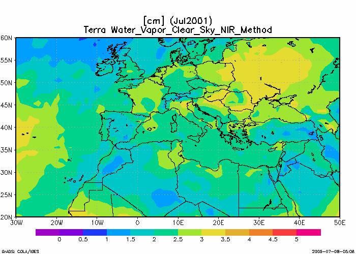
18 4 Average surface pressure for Europe in July hpa 3,5 3 WMB EMB 2,5 2 1,5 1 1-ene 28-mar 23-jun 18-sep 14-dic Total Precipitable Water Column cm
19 G LAND-USE & SURFACE CHANGES Alter the MOISTURE, HEAT, & pollutants added to seabreezes * EVAPORATION FROM SEA + Pollution Effects (e.g., nucleation) Loss of summer storms. Drought increases over coastal mountains and other inland areas Cloud Condensation Level rises above coastal mountains Combined greenhouse heating additionally increases the Sea Surface Temperature by the end of summer Non-precipitated H 2 O vapour & pollutants (O 3 ) follow the return flows aloft, and pile up in a system of layers, 4.5 to 5.5 km deep, over the sea
20 DAY 10:30 & NIGHT 22:30

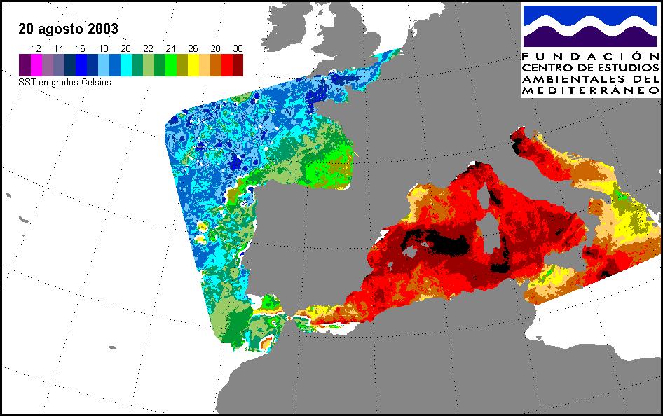
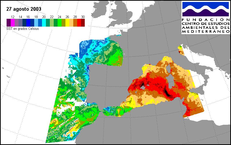
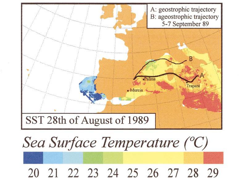
21 Sea Surface Temperature SST (August 2003)
22 G LAND-USE & SURFACE CHANGES Alter the MOISTURE, HEAT, & pollutants added to seabreezes * EVAPORATION FROM SEA + Pollution Effects (e.g., nucleation) Loss of summer storms. Drought increases over coastal mountains and other inland areas Cloud Condensation Level rises above coastal mountains Torrential rains over areas surrounding the Mediterranean increase in autumnwinter-spring Combined greenhouse heating additionally increases the Sea Surface Temperature by the end of summer Non-precipitated H 2 O vapour & pollutants (O 3 ) follow the return flows aloft, and pile up in a system of layers, 4.5 to 5.5 km deep, over the sea
23
24
25
26
27 G LAND-USE & SURFACE CHANGES Alter the MOISTURE, HEAT, & pollutants added to seabreezes * EVAPORATION FROM SEA + Pollution Effects (e.g., nucleation) Mud floods Augmented soil erosion Loss of summer storms. Drought increases over coastal mountains and other inland areas Cloud Condensation Level rises above coastal mountains Torrential rains over areas surrounding the Mediterranean increase in autumnwinter-spring Combined greenhouse heating additionally increases the Sea Surface Temperature by the end of summer Non-precipitated H 2 O vapour & pollutants (O 3 ) follow the return flows aloft, and pile up in a system of layers, 4.5 to 5.5 km deep, over the sea Aged airmass advected to other regions, in part (daily), or in toto (every 3 to 10 days)
28 Average water vapour column over the Western Mediterranean Basin in August The monthly average is equivalent to a 3-to-4 day accumulation cycle. Back trajectories (type V b ) for the August 2002 event. From EC Project MICE (Modelling the Impact of Extreme Events, ).
29 G LAND-USE & SURFACE CHANGES Alter the MOISTURE, HEAT, & pollutants added to seabreezes * EVAPORATION FROM SEA + Pollution Effects (e.g., nucleation) Mud floods Augmented soil erosion Loss of summer storms. Drought increases over coastal mountains and other inland areas Cloud Condensation Level rises above coastal mountains (+?) Perturbation to the NAO (North Atlantic Oscillation) Torrential rains over areas surrounding the Mediterranean increase in autumnwinter-spring Combined greenhouse heating additionally increases the Sea Surface Temperature by the end of summer Non-precipitated H 2 O vapour & pollutants (O 3 ) follow the return flows aloft, and pile up in a system of layers, 4.5 to 5.5 km deep, over the sea Increased salty outflow to Atlantic Changes the evaporation precipitation balance in the western basin. Salinity increases in the Mediterranean Sea Aged airmass advected to other regions, in part (daily), or in toto (every 3 to 10 days) European route-v b tracks Summer floods in Central Europe: 1997, 2002, 2005,...

30 Nature, vol 437/27, October 2005 Inventing an Icon: Hans Joachim Schellnhuber s map of global tipping points in climate change
31 British Isles & NW Europe: floods in summer; drier cold winters (snow ) G LAND-USE & SURFACE CHANGES Alter the MOISTURE, HEAT, & pollutants added to seabreezes * EVAPORATION FROM SEA + Pollution Effects (e.g., nucleation) Summer drought followed by winter floods in (Atlantic) Southwestern Europe & Northern Africa Mud floods Augmented soil erosion Loss of summer storms. Drought increases over coastal mountains and other inland areas Cloud Condensation Level rises above coastal mountains (+?) Perturbation to the NAO (North Atlantic Oscillation) Torrential rains over areas surrounding the Mediterranean increase in autumnwinter-spring Combined greenhouse heating additionally increases the Sea Surface Temperature by the end of summer Non-precipitated H 2 O vapour & pollutants (O 3 ) follow the return flows aloft, and pile up in a system of layers, 4.5 to 5.5 km deep, over the sea Increased salty outflow to Atlantic Changes the evaporation precipitation balance in the western basin. Salinity increases in the Mediterranean Sea Aged airmass advected to other regions, in part (daily), or in toto (every 3 to 10 days) Perturbations (?) to extra-tropical depressions & hurricanes, in the Western Atlantic South- Eastern USA Condensation nuclei transported across Atlantic to Caribbean Heterogeneous reactions in shallow clouds: sulphatation and nitrification of Saharan dust African routes: central and/or Southern Atlas (with vertical recirculations) European route-v b tracks Summer floods in Central Europe: 1997, 2002, 2005,...
32 SUMMARY I In Europe, there are two different hydrological regimes corresponding to the Atlantic and the Mediterranean Catchment Basins On the Atlantic side, from 100% to 80% of precipitation originates from water evaporated in the ocean. Land-use (soil-vegetation-atmosphere) plays a role in the inland propagation of the frontal systems. On the Mediterranean side, from 80% to 100% of precipitation is from water RECYCLED within the Mediterranean Basin itself. Here, soil and vegetation provide a fundamental water pumping mechanism to maintain the stability of the precipitation and the hydrological cycles. Drought and torrential rains in the Mediterranean are the result of a series of concatenated meteorological processes initiated by land use changes at the local scale. The effects of local land-use changes are cumulative, and their perturbations can propagate up to the regional-and-continental scales through the development of WATER VAPOUR ACCUMULATION MODES over the inland seas.
33 SUMMARY II These processes can lead to intense precipitation events and summer floods along the European Continental-water Divide and other parts of the Mediterranean Catchment Basin, including the islands. Moreover, through the intensification of the Atlantic-Mediterranean Salinity Valve at Gibraltar, the North Atlantic Oscillation can be perturbed and affect precipitation on the European Atlantic side. Therefore, the perturbations initiated by land-use changes at the local level in the Mediterranean may propagate their effects, and produce extreme events, in other parts of Europe. SOLUTIONS There are solutions for recovering the hydrological system, e.g., cultivating summer storms, which can be economically attractive and help to create jobs. But they require a fundamental knowledge of the mechanisms involved, and very, very well-coordinated remedial actions from the local-to-regional scales.
34 MANY THANKS FOR YOUR ATTENTION!
EC Conference: Land as a Resource Narrative for the Presentation: Land-use changes and their impact on extreme events by Millán Millán
 EC Conference: Land as a Resource 2014. Narrative for the Presentation: Land-use changes and their impact on extreme events by Millán Millán Most of the contents come from the Paper in press: Extreme hydrometeorological
Lecture 13 El Niño/La Niña Ocean-Atmosphere Interaction. Idealized 3-Cell Model of Wind Patterns on a Rotating Earth. Previous Lecture!
 Lecture 13 El Niño/La Niña Ocean-Atmosphere Interaction Previous Lecture! Global Winds General Circulation of winds at the surface and aloft Polar Jet Stream Subtropical Jet Stream Monsoons 1 2 Radiation
Water Budget I: Precipitation Inputs
 Water Budget I: Precipitation Inputs Forest Cover Global Mean Annual Precipitation (MAP) Biomes and Rainfall Forests won t grow where P < 15 / yr Forest type depends strongly on rainfall quantity, type
Chapter 8 Air Masses
 Chapter 8 Air Masses Air Masses - 1 1. An Air Mass is a large body of air usually about 1500 km across and several km thick, that has homogeneous physical properties. 2. The important physical properties
Local Winds. Please read Ahrens Chapter 10
 Local Winds Please read Ahrens Chapter 10 Scales of Motion Microscale: meters Turbulent eddies Formed by mechanical disturbance or convection Lifetimes of minutes Mesoscale: km s to 100 s of km s Local
Length of day for a full year. Ocean Gyres. Wet. Adiabatic. lapse rate, starts at. dewpoint Dry Adiabatic lapse rate
 Vernal Equinox March 20, 11:57 AM, CDT Sun will rise exactly in the east and set exactly in the west. All latitudes get 12 hours of day and 12 hours of dark. Length of day for a full year Wet Adiabatic
Social Studies CHAPTER 2: PART 2 CLIMATE AND WEATHER
 Social Studies CHAPTER 2: PART 2 CLIMATE AND WEATHER Climate Weather and Identity Climate and weather have a large influence on how Canadians build their identity. We will study the factors that contribute
SESSION THREE: FACTORS THAT INFLUENCE WEATHER IN SOUTH AFRICA
 SESSION THREE: FACTORS THAT INFLUENCE WEATHER IN SOUTH AFRICA KEY CONCEPTS: In this section we will focus on the following aspects: Factors determining the weather of South Africa Influence of the oceans
Water Budget I: Precipitation Inputs
 Water Budget I: Precipitation Inputs Forest Cover Forests and Rainfall Forests won t grow where P < 15 / yr Forest type depends strongly on rainfall quantity, type (snow, rain) and timing (summer, winter)
Equatorial upwelling. Example of regional winds of small scale
 Example of regional winds of small scale Sea and land breezes Note on Fig. 8.11. Shows the case for southern hemisphere! Coastal upwelling and downwelling. Upwelling is caused by along shore winds, that
8/29/20098 SAHRA - Watershed Visualization
 Module 3 Narration Southwestern Water Cycle 001.wav 26 sec 002.wav 10 sec 003 wav 17 sec Water on Earth is constantly on the move. Water continually circulates between the surface of Earth and the atmosphere
Ocean Currents that Redistribute Heat Globally
 Ocean Currents that Redistribute Heat Globally Ocean Circulation Ocean Currents Fig. CO7 OCEAN CURRENTS Surface ocean currents are similar to wind patterns: 1. Driven by Coriolis forces 2. Driven by winds
GEOS 201 Lab 13 Climate of Change InTeGrate Module Case studies 2.2 & 3.1
 Discerning Patterns: Does the North Atlantic oscillate? Climate variability, or short term climate change, can wreak havoc around the world. Dramatic year to year shifts in weather can have unanticipated
Chapter 9 Insolation control of monsoons 2004/4/15
 Chapter 9 Insolation control of monsoons 2004/4/15 Introduction Monsoon circulations exist on Earth today because the land responds to seasonal changes in solar radiation much more quickly than does the
Water on Earth. How do oceans relate to weather and the atmosphere? Solar Radiation and Convection Currents
 Earth is often called the Blue Planet because so much of its surface (about 71%) is covered by water. Of all the water on Earth, about 96.5% is held in the world s oceans. As you can imagine, these oceans
WINDS Understand the cause of wind and how it affects climate Chapter 4 Pages 59-67
 WINDS Understand the cause of wind and how it affects climate Chapter 4 Pages 59-67 What is Wind? A wind is a horizontal movement of air across a surface. Vertical movements are currents or updrafts and
The atmospheric circulation system
 The atmospheric circulation system Key questions Why does the air move? Are the movements of the winds random across the surface of the Earth, or do they follow regular patterns? What implications do these
The student will be expected to demonstrate an understanding of the cause of winds and how winds affect climate.
 The student will be expected to demonstrate an understanding of the cause of winds and how winds affect climate. In this lesson you will: 2.3.1 Define the term prevailing winds. (k) 2.3.3 State the impact
Atmospheric Circulation (Ch. 8) Ocean & Atmosphere are intertwined Gases & waters freely exchanged Wind Weather Climate
 Ocean & Atmosphere are intertwined Gases & waters freely exchanged Wind Weather Climate") Atmospheric Circulation (Ch. 8) Ocean & Atmosphere are intertwined Gases & waters freely exchanged Wind Weather Climate Atmospheric Structure Consists of Layers Separated by Temperature Stratosphere: Temperature
Atmospheric Circulation (Ch. 8) Ocean & Atmosphere are intertwined Gases & waters freely exchanged Wind Weather Climate Atmospheric Structure Consists of Layers Separated by Temperature Stratosphere: Temperature
Weather EOG Review Questions
 Weather EOG Review Questions 1. Which statement best describes runoff? A Water vapor cools off and changes into water droplets. B Water in the form of rain, snow, sleet, or hail falls from clouds. C Precipitation
Nevis Hulme Gairloch High School John Smith Invergordon Academy. Gairloch High School / Invergordon Academy
 Nevis Hulme Gairloch High School John Smith Invergordon Academy 1 Gairloch High School / Invergordon Academy ATMOSPHERIC CIRCULATION The Three Cell Model Global Winds The ITCZ The purpose of this presentation
Global Weather Patterns
 Global Weather Patterns AZ State Standards Concept 2: Energy in the Earth System (Both Internal and External) Understand the relationships between the Earth s land masses, oceans, and atmosphere. PO 2.
THE ATMOSPHERE. WEATHER and CLIMATE. The Atmosphere 10/12/2018 R E M I N D E R S. PART II: People and their. weather. climate?
 R E M I N D E R S Two required essays are due by Oct. 30, 2018. (A third may be used for extra credit in place of a Think Geographically essay.) ESSAY TOPICS (choose any two): Contributions of a noted
and the Link between Oceans, Atmosphere, and Weather
 Geography Worksheet Instructions Using a map, atlas, or any other materials your teacher suggests, label the following on the blank map provided. 1. Label East, West, North, and South. 2. Label the following
ESS15 Lecture 12. Review, tropical oceans & El Nino, and the thermohaline ocean circulation. Please see new reading material on website.
 ESS15 Lecture 12 Review, tropical oceans & El Nino, and the thermohaline ocean circulation. Please see new reading material on website. Review. I-clicker exercise: In this graph of Earth s energy imbalances
Canada s Natural Systems. Canadian Geography 1202
 Canada s Natural Systems Canadian Geography 1202 Canada s Natural Systems Natural System: A system found in nature Here are the four natural systems that we will explore in the next few weeks 1. Canada
Lecture 14. Heat lows and the TCZ
 Lecture 14 Heat lows and the TCZ ITCZ/TCZ and heat lows While the ITCZ/TCZ is associated with a trough at low levels, it must be noted that a low pressure at the surface and cyclonic vorticity at 850 hpa
The General Circulation and El Niño. Dr. Christopher M. Godfrey University of North Carolina at Asheville
 The General Circulation and El Niño Dr. Christopher M. Godfrey University of North Carolina at Asheville Global Circulation Model Air flow broken up into 3 cells Easterlies in the tropics (trade winds)
SIO20 - Midterm Examination 2 v1 Winter Section A. Circle the letter corresponding to the best answer. (1 point each)
") NAME: Section A. Circle the letter corresponding to the best answer. (1 point each) 1. Rainbows result from: a. refraction and reflection of sunlight by water droplets b. reflection of sunlight by oceans
NAME: Section A. Circle the letter corresponding to the best answer. (1 point each) 1. Rainbows result from: a. refraction and reflection of sunlight by water droplets b. reflection of sunlight by oceans
ATS150: Global Climate Change. Oceans and Climate. Icebergs. Scott Denning CSU 1
 The Oceans Wind-Driven Gyre Circulations Icebergs Scott Denning CSU 1 Surface Balance of Forces friction coriolis wind stress resultant current Wind stress accelerates surface water Friction couples surface
Weather & Atmosphere Study Guide
 Weather & Atmosphere Study Guide 1. Draw a simple water cycle diagram using the following words: Precipitation, Evaporation, Condensation, Transpiration 2. In your own words, explain the difference between
Effect of Orography on Land and Ocean Surface Temperature
 Present and Future of Modeling Global Environmental Change: Toward Integrated Modeling, Eds., T. Matsuno and H. Kida, pp. 427 431. by TERRAPUB, 2001. Effect of Orography on Land and Ocean Surface Temperature
OCEANOGRAPHY STUDY GUIDE
 OCEANOGRAPHY STUDY GUIDE Chapter 2 Section 1 1. Most abundant salt in ocean. Sodium chloride; NaCl 2. Amount of Earth covered by Water 71% 3. Four oceans: What are they? Atlantic, Pacific, Arctic, Indian
What is Air Temperature? Temperature, Buoyancy, and Vertical Motion. How Atmospehric Temperature is Measured. Temperature Scales
 Temperature, Buoyancy, and Vertical Motion Temperature, Pressure, and Density Buoyancy and Static Stability Temperature Lapse Rates Rising & Falling Motions in the Air What is Air Temperature? Temperature
3/22/11. General Circulation of the Atmosphere. General Circulation of the Atmosphere
 Chapter 10 General refers to the average air flow, actual winds will vary considerably. Average conditions help identify driving forces. The basic cause of the general circulation is unequal heating of
Write answers on your own paper. A. the Sun B. the Moon C. Earth s gravity D. Earth s rotation
 The tmosphere Write answers on your own paper 1. What is the primary energy source that drives all weather events, including precipitation, hurricanes, and tornados?. the Sun. the Moon C. Earth s gravity
9/25/2014. Scales of Atmospheric Motion. Scales of Atmospheric Motion. Chapter 7: Circulation of the Atmosphere
 Chapter 7: Circulation of the Atmosphere The Atmosphere: An Introduction to Meteorology, 12 th Lutgens Tarbuck Lectures by: Heather Gallacher, Cleveland State University Scales of Atmospheric Motion Small-
ATMOSPHERIC CIRCULATION. WIND = The horizontal movement of air. Results from the differences in air pressure. Always moves from HIGH to LOW.
 ATMOSPHERIC CIRCULATION WIND = The horizontal movement of air. Results from the differences in air pressure. Always moves from HIGH to LOW. Pressure differences result from variations in temperature. AIR
ATMS 310 Tropical Dynamics
 ATMS 310 Tropical Dynamics Introduction Throughout the semester we have focused on mid-latitude dynamics. This is not to say that the dynamics of other parts of the world, such as the tropics, are any
The student will be expected to demonstrate an understanding of the cause of winds and how winds affect climate.
 The student will be expected to demonstrate an understanding of the cause of winds and how winds affect climate. In this lesson you will: 2.3.1 Define the term prevailing winds. (k) 2.3.3 State the impact
Current: large mass of continuously moving ocean water
 Ocean Currents Current: large mass of continuously moving ocean water Surface Currents--Wind Circulation These waters make up about 10% of all the water in the ocean. These waters are the upper 400 meters
Name: OBJECTIVES: By the end of today s lesson, you will be able to
 7 th Grade Science Unit: Water s Cycles and Patterns Lesson: WCP 21 Name: Date: Monday, October 3, 2016 Homeroom: _ OBJECTIVES: By the end of today s lesson, you will be able to SWBAT Explain how currents
Physical Geography. Physical Geography III of the United States and Canada. Formation of Great Lakes. Climates of North America. Definitions 2/21/2013
 Physical Geography III of the United States and Canada Ancient Glacial Lakes As the Ice Age ended, areas of North America beyond the terminal moraine were flooded with melt water Prof Anthony Grande AFG
Lecture 24. El Nino Southern Oscillation (ENSO) Part 1
 Part 1") Lecture 24 El Nino Southern Oscillation (ENSO) Part 1 The most dominant phenomenon in the interannual variation of the tropical oceanatmosphere system is the El Nino Southern Oscillation (ENSO) over the
Lecture 24 El Nino Southern Oscillation (ENSO) Part 1 The most dominant phenomenon in the interannual variation of the tropical oceanatmosphere system is the El Nino Southern Oscillation (ENSO) over the
The Ocean is a Geophysical Fluid Like the Atmosphere. The Physical Ocean. Yet Not Like the Atmosphere. ATS 760 Global Carbon Cycle The Physical Ocean
 The Physical Ocean The Ocean is a Geophysical Fluid Like the Atmosphere Three real forces: Gravity Pressure gradients Friction Two apparent forces: Coriolis and Centrifugal Geostrophic & Hydrostatic balances
3. Climatic Variability. El Niño and the Southern Oscillation Madden-Julian Oscillation Equatorial waves
 Georges (1998) 3. Climatic Variability El Niño and the Southern Oscillation Madden-Julian Oscillation Equatorial waves ENVIRONMENTAL CONDITIONS FOR TROPICAL CYCLONES TO FORM AND GROW Ocean surface waters
Announcements. Why does the wind blow? What makes the ocean flow? Pressure gradients and Coriolis. First assignment (deep-sea sediments)
") Announcements First assignment (deep-sea sediments) I expect to be finished grading exams in two weeks. Second problem set due November 7th New topic: Physics of atmospheric and oceanic circulation Atmospheric
Announcements First assignment (deep-sea sediments) I expect to be finished grading exams in two weeks. Second problem set due November 7th New topic: Physics of atmospheric and oceanic circulation Atmospheric
El Niño Lecture Notes
 El Niño Lecture Notes There is a huge link between the atmosphere & ocean. The oceans influence the atmosphere to affect climate, but the atmosphere also influences the ocean, which can also affect climate.
Agronomy 406 World Climates
 Agronomy 406 World Climates January 30, 2018 Monsoons. Ocean properties and circulation. Review for today: Online textbook: 1.3.1 (Sea water) Composition and properties. For Thursday: Rahmstorf, S.: The
Goals for today: continuing Ch 8: Atmospheric Circulation and Pressure Distributions. 26 Oct., 2011
 Goals for today: 26 Oct., 2011 continuing Ch 8: Atmospheric Circulation and Pressure Distributions Examples of synoptic scale and mesoscale circulation systems that are driven by geographic diversity in
Weather drivers in South Australia
 August 2008 Key facts Weather drivers in South Australia Major weather drivers in South Australia are: El Niño - Southern Oscillation frontal systems cut-off lows blocking highs Indian Ocean Dipole cloudbands
Meteorology. Circle the letter that corresponds to the correct answer
 Chapter 7 Worksheet 2 Meteorology Name: Circle the letter that corresponds to the correct answer 1) Which of the following factors contributes to the general subsidence in the latitude zone 20 degrees
Meteorology I Pre test for the Second Examination
 Meteorology I Pre test for the Second Examination MULTIPLE CHOICE 1. A primary reason why land areas warm up more rapidly than water areas is that a) on land, all solar energy is absorbed in a shallow
Trade winds How do they affect the tropical oceans? 10/9/13. Take away concepts and ideas. El Niño - Southern Oscillation (ENSO)
") El Niño - Southern Oscillation (ENSO) Ocean-atmosphere interactions Take away concepts and ideas What is El Niño, La Niña? Trade wind and Walker circulation. What is the Southern Oscillation? Tropical
El Niño - Southern Oscillation (ENSO) Ocean-atmosphere interactions Take away concepts and ideas What is El Niño, La Niña? Trade wind and Walker circulation. What is the Southern Oscillation? Tropical
Review for the second quarter. Mechanisms for cloud formation
 Review for the second quarter Mechanisms for cloud formation 1 Rising air expands and cools; Sinking air compresses and warms. (18) (24) Dry adiabatic lapse rate (10 o C/km): the rate of temperature decrease
Wind: Small-scale and Local Systems
 Wind: Small-scale and Local Systems Scales of Atmospheric Motion Atmospheric motions/phenomena occur on many diverse spatial and temporal scales. Weather forecasters tend to focus on Mesoscale and synoptic
IX. Upper Ocean Circulation
 IX. Upper Ocean Circulation World Ocean Covers 71% of Earth s surface Contains 97% of surface water Arctic Ocean NH: 61% ocean, 39% land Pacific Ocean Atlantic Ocean Southern Ocean Indian Ocean SH: 81%
Weather drivers in Victoria
 August 2008 Weather drivers in Victoria Key facts Major weather drivers in Victoria are: El Niño - Southern Oscillation frontal systems cut-off lows blocking highs Southern Annular Mode cloudbands Figure
How fast will be the phase-transition of 15/16 El Nino?
 How fast will be the phase-transition of 15/16 El Nino? YOO-GEUN HAM D E P A R T M E N T O F O C E A N O G R A P H Y, C H O N N A M N A T I O N A L U N I V E R S I T Y 2015/16 El Nino outlook One of strongest
Chapter- 9. Multiple Choice Questions
 Chapter- 9 Multiple Choice Questions 1. The low-latitude climates: a. are located along the equator b. are located between the tropics of cancer and capricorn c. do not include the ITCZ d. are restricted
McKnight's Physical Geography 11e
 Chapter 2 Lecture McKnight's Physical Geography 11e Lectures Chapter 5 Atmospheric Pressure and Wind Michael Commons Ohio Northern University Atmospheric Pressure and Wind The Nature of Atmospheric Pressure
Scales of Atmospheric Motion
 Lecture 12 Local Wind Systems Scales of Atmospheric Motion Small turbulent eddies (swirls) A synoptic eddy 1 Coriolis Effect The larger the scale, the longer the life time. Wind shear and turbulent eddy
REMINDERS: UPCOMING REVIEW SESSIONS: - Thursday, Feb 27, 6:30-8:00pm in HSS 1330
 REMINDERS: Midterm 2: Friday, February 28 - lecture material covering chapters 6, 7, and 15 (since first midterm and through Wed lecture) - same Format as first midterm UPCOMING REVIEW SESSIONS: - Thursday,
OCEANOGRAPHY 101. Map, and temperature, salinity & density profiles of the water column at X, near mouth of the Columbia River.
 OCEANOGRAPHY 101 EXAM 2 WINTER 00 NAME STUDENT NUMBER 1 Map, and temperature, salinity & density profiles of the water column at X, near mouth of the Columbia River. P a c i f i c O c e a n X WA Columbia
Applied Earth Science Climate Exam Practice Questions Page 1
 Name: 1. Which combination of climate factors generally results in the coldest temperatures? A) low elevation and low latitude B) low elevation and high latitude C) high elevation and low latitude D) high
LAB H - ATMOSPHERE AND CLIMATE LAB II STABILITY AND PRECIPITATION PATTERNS
 Introduction LAB H - ATMOSPHERE AND CLIMATE LAB II STABILITY AND PRECIPITATION PATTERNS This lab will provide students with the opportunity to become familiar with the concepts of atmospheric stability
Currents. History. Pressure Cells 3/13/17. El Nino Southern Oscillation ENSO. Teleconnections and Oscillations. Neutral Conditions
 Teleconnections and Oscillations Teleconnection climate anomalies being related to each other over a large scale Oscillations: Macroscale movement of atmospheric systems that can influence weather, climate,
Unit 11 Lesson 2 How Does Ocean Water Move? Copyright Houghton Mifflin Harcourt Publishing Company
 Unit 11 Lesson 2 How Does Ocean Water Move? Catch a Wave A wave is the up-and-down movement of surface water. Catch a Wave Catch a Wave (wave effects) Surface waves are caused by wind pushing against
9. The Earth's planetary winds are deflected as a result of the Earth's A) revolution around the Sun B) seasonal changes C) rotation on its axis D)
 revolution around the Sun B) seasonal changes C) rotation on its axis D)") 1. Which ocean current transports warm water away from Earth s equatorial region? A) Brazil Current B) Guinea Current C) Falkland Current D) California Current 2. The Gulf Stream and North Atlantic Current
1. Which ocean current transports warm water away from Earth s equatorial region? A) Brazil Current B) Guinea Current C) Falkland Current D) California Current 2. The Gulf Stream and North Atlantic Current
Dust radiative forcing and Heat Low dynamics over West Africa
 Dust radiative forcing and Heat Low dynamics over West Africa Cyrille Flamant 1, Juan Cuesta 2, Christophe Lavaysse 3, Ridha Guebsi 1, Marco Gaetani 1, Wenje Wang 4 & Amato Evan 4 1 LATMOS/IPSL, UPMC Univ.
Atmospheric Circulation
 Atmospheric Circulation Why do we say Earth's temperature is moderate? It may not look like it, but various processes work to moderate Earth's temperature across the latitudes. Atmospheric circulation
2015 Evelyn Browning Garriss. El Niño, the Twisted Atlantic and the Effect on Global Agriculture
 2015 Evelyn Browning Garriss El Niño, the Twisted Atlantic and the Effect on Global Agriculture Conclusions Climate change is not linear. It ebbs and flows. Recent polar volcano eruptions created a cool
Understanding El Nino-Monsoon teleconnections
 Understanding El Nino-Monsoon teleconnections Dr Neena Joseph Mani Earth & Climate Science INSA Anniversary General meeting, Session: Science in IISER Pune 27 th December 2017 Mean State of the equatorial
1.3: CLIMATE GEOGRAPHY. pgs
 1.3: CLIMATE GEOGRAPHY pgs. 76-89 INTRODUCTION WEATHER: Is the combination of temperature, precipitation, cloud cover and wind that we experience EACH DAY. Example: 22 0 C and clear skies. CLIMATE: The
Winds and Ocean Circulations
 Winds and Ocean Circulations AT 351 Lab 5 February 20, 2008 Sea Surface Temperatures 1 Temperature Structure of the Ocean Ocean Currents 2 What causes ocean circulation? The direction of most ocean currents
The Movement of Ocean Water. Currents
 The Movement of Ocean Water Currents Ocean Current movement of ocean water that follows a regular pattern influenced by: weather Earth s rotation position of continents Surface current horizontal movement
Performance of three Selected Convective Schemes for Predicting Indian Summer Monsoon Rainfall using RegCM4.4
 Performance of three Selected Convective Schemes for Predicting Indian Summer Monsoon Rainfall using RegCM4.4 A.K.M. Saiful Islam Professor Institute of Water and Flood Management Bangladesh University
Monsoon. Arabic word mausim means season. Loose definition: a wind/precipitation pattern that shifts seasonally
 Monsoon Arabic word mausim means season Loose definition: a wind/precipitation pattern that shifts seasonally Classical criteria (Ramage 1971) Prevailing wind shifts 120 o between Jan & July Average frequency
Atmospheric Dispersion, Transport and Deposition. Dispersion. Wind Speed. EOH 468 Spring 2008 Dr. Peter Bellin, CIH, Ph.D.
 Atmospheric Dispersion, Transport and Deposition EOH 468 Spring 2008 Dr. Peter Bellin, CIH, Ph.D. Dispersion Atmospheric process affect dilution. Wind speed and lapse rate impact on emissions. Planetary
Atmospheric Circulation. Recall Vertical Circulation
 Today s topics: Atmospheric circulation: generation of wind patterns on a rotating Earth Seasonal patterns of climate: Monsoons and Sea Breezes Tropical Cyclones: Hurricanes and typhoons Atmospheric Circulation
Global Circulations. GEOG/ENST 2331 Lecture 15 Ahrens: Chapter 10
 Global Circulations GEOG/ENST 2331 Lecture 15 Ahrens: Chapter 10 Last lecture Microscale (turbulence) Mesoscale (land/sea breeze) Synoptic scale (monsoon) Global scale (3 cell circulation) Three Cell Model
Canada s vast size creates a diverse range of weather conditions and climatic conditions. Warming trend for last 10 years Wet Spring Dry five summers
 Chapter 4 Weather and Climate Canada s vast size creates a diverse range of weather conditions and climatic conditions. Weather examples: Rainy today Snow tomorrow Fog on Wednesday 23 degree C today High
Local Winds & Microclimates. Unit 2- Module 1
 Local Winds & Microclimates Unit 2- Module 1 Objectives Overview of local winds (sea & land breezes, valley winds) Overview of microclimates (valley, urban, woodland) Local Winds Local Winds Local winds
NOTE ->->-> DUE THURSDAY APRIL 20 TH 2006 THAT IS CORRECT I FORGOT THIS IS EASTER WEEKEND SO I HAVE EXTENDED THE DUE DATE TO THE ABOVE
 GEO 130 NAME OCEANOGRAPHY TEST 3 TAKE HOME TEST SPRING 2006 NOTE ->->-> DUE THURSDAY APRIL 20 TH 2006 THAT IS CORRECT I FORGOT THIS IS EASTER WEEKEND SO I HAVE EXTENDED THE DUE DATE TO THE ABOVE This test
Summary of Lecture 10, 04 March 2008 Introduce the Hadley circulation and examine global weather patterns. Discuss jet stream dynamics jet streams
 Summary of Lecture 10, 04 March 2008 Introduce the Hadley circulation and examine global weather patterns. Discuss jet stream dynamics jet streams arise because the Coriolis force prevents Hadley-type
Changing Climate and the Outlook
 Changing Climate and the Outlook for Oilseed 2016 Evelyn Browning Garriss Conclusions Climate change is not linear. It ebbs and flows. There is a 90% chance the current El Niño will be strong and last
Fluid Circulation (Student Mastery Objectives) -The most frequent type of heat transfer of energy in the atmosphere is convection.
 -The most frequent type of heat transfer of energy in the atmosphere is convection.") Fluid Circulation (Student Mastery Objectives) -The most frequent type of heat transfer of energy in the atmosphere is convection. -Differences in density affect the circulation of fluids. Cold air is
Fluid Circulation (Student Mastery Objectives) -The most frequent type of heat transfer of energy in the atmosphere is convection. -Differences in density affect the circulation of fluids. Cold air is
ENSO Cycle: Recent Evolution, Current Status and Predictions. Update prepared by Climate Prediction Center / NCEP 8 March 2010
 ENSO Cycle: Recent Evolution, Current Status and Predictions Update prepared by Climate Prediction Center / NCEP 8 March 2010 Outline Overview Recent Evolution and Current Conditions Oceanic Niño Index
OCN 201 Surface Circulation
 OCN 201 Surface Circulation Excess heat in equatorial regions requires redistribution toward the poles 1 In the Northern hemisphere, Coriolis force deflects movement to the right In the Southern hemisphere,
Santa Ana Winds. Surface weather map showing typical Santa Ana conditions.
 Santa Ana Winds Surface weather map showing typical Santa Ana conditions. High Desert Elevation ~1500-2000 ft Santa Ana Winds ~1500 meters 0 meters Santa Ana Winds ~875 mb ~1500 meters ~875 mb Horizontal
Moisture and Stability in the Atmosphere
 Moisture and Stability in the Atmosphere Humidity can be measured as: HUMIDITY Absolute humidity the mass of water vapour in a volume of air (g/m 3.) Relative Humidity the proportion of the actual mass
HYDROSPHERE, OCEANS AND TIDES
 HYDROSPHERE, OCEANS AND TIDES Revision 10x10learning.com 1 Chapter 12. In the Earth s Atmosphere On surface of the Earth Under the ground Hydrosphere comprises of ALL WATER Water Vapour = 0.001% Is very
LAB H - ATMOSPHERE AND CLIMATE LAB II STABILITY AND PRECIPITATION PATTERNS
 Introduction LAB H - ATMOSPHERE AND CLIMATE LAB II STABILITY AND PRECIPITATION PATTERNS This lab will provide students with the opportunity to become familiar with the concepts of atmospheric stability
Name Date L.O: SWBAT explain what breezes, planetary winds, ocean currents & monsoons are.
 Name Date L.O: SWBAT explain what breezes, planetary winds, ocean currents & monsoons are. 1. A cool breeze is blowing toward the land from the ocean on a warm, cloudless summer day. This condition is
Conditions for Offshore Wind Energy Use
 Carl von Ossietzky Universität Oldenburg Institute of Physics Energy Meteorology Group Detlev Heinemann Conditions for Offshore Wind Energy Use Detlev Heinemann ForWind Carl von Ossietzky Universität Oldenburg
3 Global Winds and Local Winds
 CHAPTER 1 3 Global Winds and Local Winds SECTION The Atmosphere BEFORE YOU READ After you read this section, you should be able to answer these questions: What causes wind? What is the Coriolis effect?
Wednesday, September 20, 2017 Reminders. Week 3 Review is now available on D2L (through Friday) Exam 1, Monday, September 25, Chapters 1-4
 Exam 1, Monday, September 25, Chapters 1-4") Wednesday, September 20, 2017 Reminders Week 3 Review is now available on D2L (through Friday) Exam 1, Monday, September 25, Chapters 1-4 PLEASE don t memorize equations, but know how to recognize them
Wednesday, September 20, 2017 Reminders Week 3 Review is now available on D2L (through Friday) Exam 1, Monday, September 25, Chapters 1-4 PLEASE don t memorize equations, but know how to recognize them
Sryan Bruen The Restless Atmosphere Notes (JC Geography)
") Sryan Bruen The Restless Atmosphere Notes (JC Geography) What is the Atmosphere? A blanket of gases surrounding the Earth. It is made up of different gases including Nitrogen (78%), Oxygen (21%) and others
Sryan Bruen The Restless Atmosphere Notes (JC Geography) What is the Atmosphere? A blanket of gases surrounding the Earth. It is made up of different gases including Nitrogen (78%), Oxygen (21%) and others
Scott Denning CSU CMMAP 1
 Thermodynamics, Buoyancy, and Vertical Motion Temperature, Pressure, and Density Buoyancy and Static Stability Adiabatic Lapse Rates Dry and Moist Convective Motions Present Atmospheric Composition What
Latitude Altitude (Elevation) Proximity to large bodies of water Ocean Currents. larger. concentrated. direct. heating. heating.
 Proximity to large bodies of water Ocean Currents. larger. concentrated. direct. heating. heating.") Climographs Climographs Climographs Roles of Temperature and Precipitation on Climate Roles of Temperature and Precipitation on Climate : Altitude (Elevation) Proximity to large bodies of water Ocean Currents
Climographs Climographs Climographs Roles of Temperature and Precipitation on Climate Roles of Temperature and Precipitation on Climate : Altitude (Elevation) Proximity to large bodies of water Ocean Currents