Historical and Current Climate in the Rio Grande National Forest Area. Peter Goble Nolan Doesken 10/19/2016
|
|
|
- Ashley Thompson
- 6 years ago
- Views:
Transcription

1 Historical and Current Climate in the Rio Grande National Forest Area Peter Goble Nolan Doesken 10/19/2016
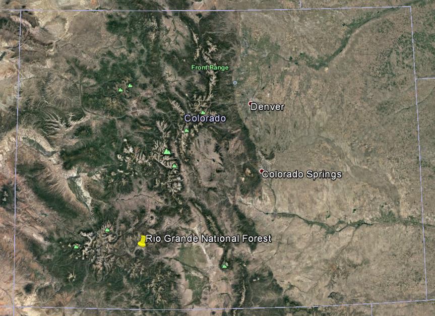
2 Geographic Orientation
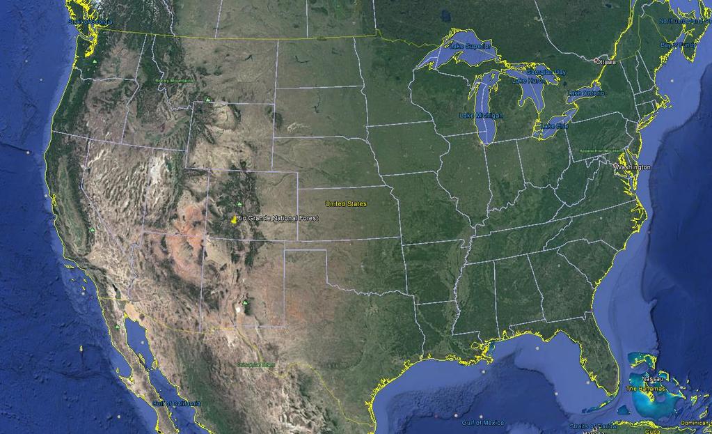
3 Geographic Orientation
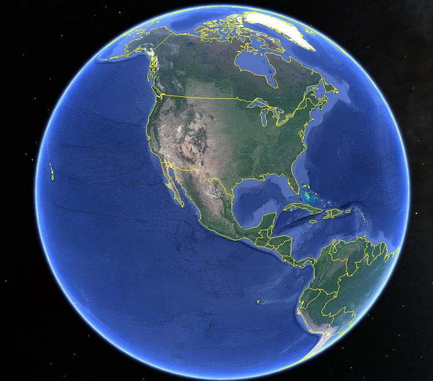
4 Geographic Orientation
5 Rio Grande National Forest Climate Normals

6 Rio Grande National Forest Climate Normals

7 Rio Grande National Forest Climate Normals

8 Rio Grande National Forest Climate Normals
9 Rio Grande National Forest Temperature and Precipitation Extremes
10 Summer Frost Free Days Nocturnal pooling of cold air in the valleys makes for a short growing season The high valleys of the Rio Grande National Forest sometimes experience a frost free season shorter than a month Frost free days trending strongly positively over the past decade

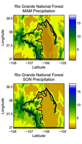
11 Annual Precipitation Distribution 2002
12 Heaviest 24-hour Totals on Record

13 Timing of Heavy Precipitation
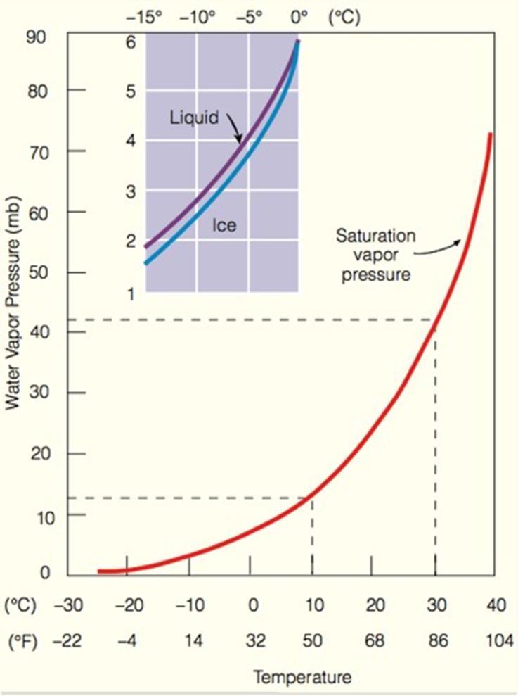
14 It s finger-cracklingly dry
15 It s cold, but very sunny Solar radiation received will vary largely based on mountain slope angle The downward enhanced downward trend in July and August presumably is related to monsoonal activity Potential for high downward solar flux always maximizes on the summer solstice
16 Gridded Mean Annual Snowfall (kind of)
17 Basic Climate Conclusions Rio Grande National Forest climate varies most primarily by latitude The landlocked nature of the forest leads to predominantly dry conditions and large swings in temperatures both diurnally and annually Due to drainage of cold air into mountain valleys the frost-free season is short Intense precipitation events are possible in the valleys only in summer, but for most of the year in the mountains Precipitation varies more absolutely in the mountains, but as a percent of normal in the valleys
18 35-year Precipitation Trends
19 35-year Maximum Temperature Trends
20 35-year Minimum Temperature Trends

21 Long-term Climate Trends (Hermit)

22 Long-term Climate Trends (Del Norte)
 1")
23 Gridded Mean Annual Snowfall (kind of) 1 2 3
24 30-Year Snowfall Trends
25 Seasonal Snowfall Disclaimer: What was has actually been shown using reanalysis data is the liquid water content from snowfall multiplied by 10 On average, 10 of fresh snowfall will melt down to 1 of water, but this is NOT a constant Snow:liquid ratios can vary by as much as 40:1 in champagne powder-type events to 3:1 or less in slush, or rain-snow mix events Numerical weather models, satellites, and automated weather stations all do not handle this well. If you want good snowfall measurements, manual measurements are still the gold standard

26 Snowfall: We still need ground reports!

27 Gridded March Mean Snowpack

28 Gridded Mean Annual Snowfall (kind of)
29 High Elevation Snowpack Trending Downwards

30 Snowpack in Less Vital Areas

31 Snowpack in Less Vital Areas
32 This is seasonal forecasting, so signal:noise ratio is low 2012 was Steamboat s worst year in the last 30, and that was a La Niña 2002 was Wolf Creek s worst year, and was near neutral
33 Seasonal Breakdown of Trend Significance High and low elevations have experienced significant warming of daily minimum temperatures over the last 30 years Long-term climate data in the area are sparse, and changes in observers, equipment, and location have all influenced trends Warming of daily maximum temperatures more significant at higher elevations, and in summer and fall In many cases the scale of year-to-year variability is larger than that of trends ENSO a poor predictor of seasonal temperature and precipitation for the Rio Grande National Forest

34 Streamflow Peak Precipitation season and peak flows uniquely out of phase Rain on snow flooding is rare compared to other parts of Colorado Summer and fall flash floods still possible


35 Wind Patterns of a Mountain Climate
36 Windward and Leeward Weather As air rises over a mountain it expands and cools Cool air cannot hold as much water, so condensation occurs Condensation releases latent heat, which opposes the cooling effect It is difficult for large storms to hit the forest since it is shadowed by mountains on three sides When a storm hits, and stable air is over head warm, windy weather will occur

37 Windward and Leeward Weather When air is stable on the other side of the mountain it descends The descending air is compressed, which has a warming effect This warm, dry air descends into the valleys and can melt snow quickly It is difficult for large storms to hit the forest since it is shadowed by mountains on three sides When a storm hits, and stable air is over head warm, windy weather will occur
38 Higher Elevation = More Solar Radiation Some sunlight passing through the atmosphere is reflected back to space by clouds, air and dust before reaching the surface Some sunlight is absorbed before reaching the surface Consequence: Higher elevations (while colder) actually receive more intense sunlight Wear sunscreen!
39 Thunderstorm Generation In the early morning air has stratified according to density with cool air in the valleys (ie bubbles 1 and 2 are at the same elevation and the same density, same with 3 and 4) In this example prevailing winds above mountain top in what we call the free atmosphere are westerly 5:30 AM
40 Thunderstorm Generation In the late morning the sun is out, and the surface is absorbing the lion s share of the energy Higher elevation surfaces have more radiation impinging on them than low elevation surfaces do This energy starts to warm the air nearest the ground and make it less dense 11:00 AM
41 Thunderstorm Generation By 1:00 PM (solar noon) a warm bubble of air has formed over the high mountains and started to rise. This air is being replaced by less dense air at the same elevation. The rising air saturates and forms a cloud. Condensed water has less energy than water vapor. The energy from the vapor is not destroyed, but released to the atmosphere as heat. 1:00 PM
42 Thunderstorm Generation By mid-afternoon the near-surface air has warmed and begun to rise at all levels. The air initially near the mountain top surface has become heavy with water and begins to rain. It travels back out over the plains in the direction of the prevailing winds This air is replaced by air from further down rushing up the mountain slope. 2:30 PM
43 Thunderstorm Generation Air all the way down to the valley surface rushes up the mountain slopes The thunderstorm propagates out over the plains in the direction of the upper-level prevailing winds Sun-warmed surface air is replaced by cooler air flowing out of the thunderstorm :00 PM
44 Thunderstorm Timing 4b3df094bbd2a5e02.mp4
45 Cold Air Pooling A snowy land surface efficiently radiates away energy during the night. This cools the near surface air The coolest air becomes the most dense and sinks into the mountain valleys Strength of these nighttime inversions may exceed 15 degrees F/thousand feet D1 P1 P2 4:00 PM
46 Cold Air Pooling A snowy land surface efficiently radiates away energy during the night. This cools the near surface air The coolest air becomes the most dense and sinks into the mountain valleys Strength of these nighttime inversions may exceed 15 degrees F/thousand feet D1 P1 P2 9:00 PM
47 Cold Air Pooling A snowy land surface efficiently radiates away energy during the night. This cools the near surface air The coolest air becomes the most dense and sinks into the mountain valleys Strength of these nighttime inversions may exceed 15 degrees F/thousand feet D1 P2 P1 3:00 AM
48 A snowy land surface efficiently radiates away energy during the night. This cools the near surface air The coolest air becomes the most dense and sinks into the mountain valleys Strength of these nighttime inversions may exceed 15 degrees F/thousand feet Cold Air Pooling

49 Mountain Slope Angle and Climate

50 Weather Safety (Lightning)

51 Weather Safety (Lightning) Each lightning bolt represents the location of a deadly strike in Colorado Both Crestone and Mineral do appear on the list Summer afternoons are the most dangerous time of day and year Locations above tree line are more dangerous than below tree line

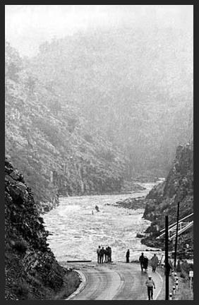
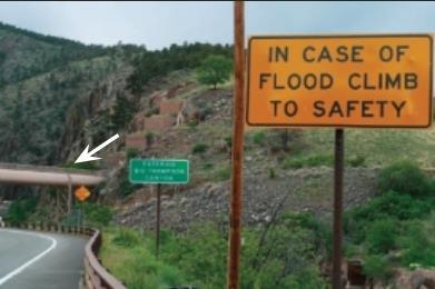
52 Weather Safety (Floods)
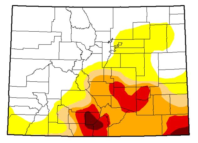
53 Drought

54 Fires Being warm and dry in the late spring can make the forest vulnerable to fires There have been no fire fatalities in the Rio Grande National Forest since at least 1970 (keep it up!) Fire vulnerability is expected to increase in future climates (Rocca 2014)

55 West Fork Complex Fire The worst fire in the Rio Grande National Forest occurred in early July of 2013 This fire burned over 100,000 acres The worst of the drought had passed, but the area had receive less than 50% of normal precipitation in the 90 days leading up to the fire

56 We Could Use More RAWS Stations
57 Historic Blizzards
58 Conclusions

59 Blue Park Great Sand Dunes Bighorn
60 Precipitation Trends ( /Decade) Winter Spring Summer Fall Annual Since Since Since Maximum Temperature (F/Decade) Winter Spring Summer Fall Annual Since Since Since Minimum Temperature (F/Decade) Winter Spring Summer Fall Annual Since Since Since Precipitation ("/Decade) Winter Spring Summer Fall Annual Since Since Since Maximum Temperature (F/Decade) Winter Spring Summer Fall Annual Since Since Since Minimum Temperature (F/Decade) Winter Spring Summer Fall Annual Since Since Since
61 Precipitation ("/Decade) Winter Spring Summer Fall Annual Since Since Since Maximum Temperature (F/Decade) Winter Spring Summer Fall Annual Since Since Since Minimum Temperature (F/Decade) Winter Spring Summer Fall Annual Since Since Since Minimum Temperature (F/Decade) Winter Spring Summer Fall Annual Since Since Since
62 15-Day Running Average Temperatures for a Rio Grande National Forest Low Mountain Valley, High Mountain Valley, and Mountain Pass

63 Monthly Average Temperatures for a Rio Grande National Forest Low Mountain Valley, High Mountain Valley, and Mountain Pass Station
64
65
Notepack 41. Aim: What factors determine the climate of a certain area? Do Now: What is the difference between weather and climate?
 Notepack 41 Aim: What factors determine the climate of a certain area? Do Now: What is the difference between weather and climate? WEATHER VS. CLIMATE Weather atmospheric conditions at a certain location
Atmosphere Circulation
 Atmosphere Circulation Winds What Causes Winds? Difference in air pressure due to unequal heating of the atmosphere. Temperatures vary according to the amount of sun it gets. Uneven heating of the Earth
Meteorology. Circle the letter that corresponds to the correct answer
 Chapter 4 Worksheet 3 Meteorology Name: Circle the letter that corresponds to the correct answer 1) Natural convection and turbulence are most likely to occur when: a) temperature decreases rapidly with
Local Winds & Microclimates. Unit 2- Module 1
 Local Winds & Microclimates Unit 2- Module 1 Objectives Overview of local winds (sea & land breezes, valley winds) Overview of microclimates (valley, urban, woodland) Local Winds Local Winds Local winds
Weather & Atmosphere Study Guide
 Weather & Atmosphere Study Guide 1. Draw a simple water cycle diagram using the following words: Precipitation, Evaporation, Condensation, Transpiration 2. In your own words, explain the difference between
Meteorology I Pre test for the Second Examination
 Meteorology I Pre test for the Second Examination MULTIPLE CHOICE 1. A primary reason why land areas warm up more rapidly than water areas is that a) on land, all solar energy is absorbed in a shallow
Climate of Colorado. Climatography of the United States No. 60 (updated 1/2003) Prepared by
 Prepared by") Climate of Colorado Climatography of the United States No. 60 (updated 1/2003) Prepared by Nolan J. Doesken, Roger A. Pielke, Sr., and Odilia A.P. Bliss Colorado Climate Center, Atmospheric Science Department,
Climate of Colorado Climatography of the United States No. 60 (updated 1/2003) Prepared by Nolan J. Doesken, Roger A. Pielke, Sr., and Odilia A.P. Bliss Colorado Climate Center, Atmospheric Science Department,
Chapter 7 Weather and Climate
 Chapter 7 Weather and Climate *Describe what weather is, what affects it, and where it occurs. *Explain the connection between air pressure and wind. * *Many factors affect a region s weather. * *atmosphere
You Can Die Here PRACTICE Regents Exam Questions
 You Can Die Here PRACTICE Regents Exam Questions 1. Which diagram best illustrates how air rising over a mountain produces precipitation? (1) (3) (2) (4) 2. As a parcel of air rises, its temperature will
Cloud Development and Forms
 Chapter 6 Lecture Understanding Weather and Climate Seventh Edition Cloud Development and Forms Redina L. Herman Western Illinois University Mechanisms That Lift Air When air lifts, clouds develop and
Latitude Altitude (Elevation) Proximity to large bodies of water Ocean Currents. larger. concentrated. direct. heating. heating.
 Proximity to large bodies of water Ocean Currents. larger. concentrated. direct. heating. heating.") Climographs Climographs Climographs Roles of Temperature and Precipitation on Climate Roles of Temperature and Precipitation on Climate : Altitude (Elevation) Proximity to large bodies of water Ocean Currents
Climographs Climographs Climographs Roles of Temperature and Precipitation on Climate Roles of Temperature and Precipitation on Climate : Altitude (Elevation) Proximity to large bodies of water Ocean Currents
Global Weather Patterns
 Global Weather Patterns AZ State Standards Concept 2: Energy in the Earth System (Both Internal and External) Understand the relationships between the Earth s land masses, oceans, and atmosphere. PO 2.
8/29/20098 SAHRA - Watershed Visualization
 Module 3 Narration Southwestern Water Cycle 001.wav 26 sec 002.wav 10 sec 003 wav 17 sec Water on Earth is constantly on the move. Water continually circulates between the surface of Earth and the atmosphere
Chapter 4: Moisture and Atmospheric Stability The hydrologic cycle
 Chapter 4: Moisture and Atmospheric Stability The hydrologic cycle from: USGS http://water.usgs.gov/edu/watercycle.html Evaporation: enough water to cover the entire surface of Earth to 1 meter cycles
Canada s vast size creates a diverse range of weather conditions and climatic conditions. Warming trend for last 10 years Wet Spring Dry five summers
 Chapter 4 Weather and Climate Canada s vast size creates a diverse range of weather conditions and climatic conditions. Weather examples: Rainy today Snow tomorrow Fog on Wednesday 23 degree C today High
Atmospheric & Ocean Circulation-
 Atmospheric & Ocean Circulation- Overview: Atmosphere & Climate Atmospheric layers Heating at different latitudes Atmospheric convection cells (Hadley, Ferrel, Polar) Coriolis Force Generation of winds
Canada s Natural Systems. Canadian Geography 1202
 Canada s Natural Systems Canadian Geography 1202 Canada s Natural Systems Natural System: A system found in nature Here are the four natural systems that we will explore in the next few weeks 1. Canada
Weather Unit Study Guide
 Weather Unit Study Guide - 2018 Weather vs Climate What does weather measure? The condition of the earth's atmosphere at a particular time and place. How are climate and weather different? Climate is the
Winds and Ocean Circulations
 Winds and Ocean Circulations AT 351 Lab 5 February 20, 2008 Sea Surface Temperatures 1 Temperature Structure of the Ocean Ocean Currents 2 What causes ocean circulation? The direction of most ocean currents
1.3: CLIMATE GEOGRAPHY. pgs
 1.3: CLIMATE GEOGRAPHY pgs. 76-89 INTRODUCTION WEATHER: Is the combination of temperature, precipitation, cloud cover and wind that we experience EACH DAY. Example: 22 0 C and clear skies. CLIMATE: The
Lesson: Atmospheric Dynamics
 Lesson: Atmospheric Dynamics By Keith Meldahl Corresponding to Chapter 8: Atmospheric Circulation Our atmosphere moves (circulates) because of uneven solar heating of the earth s surface, combined with
Social Studies CHAPTER 2: PART 2 CLIMATE AND WEATHER
 Social Studies CHAPTER 2: PART 2 CLIMATE AND WEATHER Climate Weather and Identity Climate and weather have a large influence on how Canadians build their identity. We will study the factors that contribute
Weather EOG Review Questions
 Weather EOG Review Questions 1. Which statement best describes runoff? A Water vapor cools off and changes into water droplets. B Water in the form of rain, snow, sleet, or hail falls from clouds. C Precipitation
MET Lecture 8 Atmospheric Stability
 MET 4300 Lecture 8 Atmospheric Stability Stability Concept Stable: Ball returns to original position Neutral: Ball stays wherever it is placed Unstable: Displacement grows with time. Atmospheric Stability
Atmosphere & Weather. Earth Science
 Atmosphere & Weather Earth Science Energy Transfer in the Atmosphere Earth s energy is provided by the SUN! Energy is important to us because it 1. Drives winds and ocean currents. 2. Allows plants to
Earth s Atmosphere. Earth s atmosphere is a key factor in allowing life to survive here.
 Chapter 10.2 Earth s Atmosphere Earth s atmosphere is a key factor in allowing life to survive here. This narrow band of air has the right ingredients and maintains the correct temperature, to allow life
What Causes Different Weather?
 What Causes Different Weather? Table of Contents What causes weather?...3 What causes it to rain or snow?...4 What causes flooding?...5 What causes hail?...6 What causes the seasons?...7-8 What causes
Jeopardy Q $100 Q $100 Q $100 Q $100 Q $100 Q $200 Q $200 Q $200 Q $200 Q $200 Q $300 Q $300 Q $300 Q $300 Q $300 Q $400 Q $400 Q $400 Q $400 Q $400
 Jeopardy Grab Bag Review Grab Bag Review 2 Biomes Climate Factors that affect climate Q $100 Q $200 Q $300 Q $400 Q $500 Q $100 Q $100 Q $100 Q $100 Q $200 Q $200 Q $200 Q $200 Q $300 Q $300 Q $300 Q $300
MET 200 Lecture 11 Local Winds. Last Lecture: Forces. Review of Forces. Balance of Forces
 MET 200 Lecture 11 Local Winds Last Lecture: Forces Scales of Motion Eddies Sea Breeze Mountain-Valley Circulations Chinook - Snow Eater Drainage Wind - Katabatic Wind 1 2 Review of Forces 1. Pressure
Write answers on your own paper. A. the Sun B. the Moon C. Earth s gravity D. Earth s rotation
 The tmosphere Write answers on your own paper 1. What is the primary energy source that drives all weather events, including precipitation, hurricanes, and tornados?. the Sun. the Moon C. Earth s gravity
Bell Ringer. taking next year? 1. This is the first day of the last term. Set. 2. What science are you planning on
 Bell Ringer 1. This is the first day of the last term. Set a specific goal for these last 2.5 months (not just get good grades or don t fail or wake up on time. How are you going to do these things. Set
Water Budget I: Precipitation Inputs
 Water Budget I: Precipitation Inputs Forest Cover Forests and Rainfall Forests won t grow where P < 15 / yr Forest type depends strongly on rainfall quantity, type (snow, rain) and timing (summer, winter)
Ocean Currents that Redistribute Heat Globally
 Ocean Currents that Redistribute Heat Globally Ocean Circulation Ocean Currents Fig. CO7 OCEAN CURRENTS Surface ocean currents are similar to wind patterns: 1. Driven by Coriolis forces 2. Driven by winds
Water Budget I: Precipitation Inputs
 Water Budget I: Precipitation Inputs Forest Cover Global Mean Annual Precipitation (MAP) Biomes and Rainfall Forests won t grow where P < 15 / yr Forest type depends strongly on rainfall quantity, type
Horizontal movement of air between cooler and warmer regions. - horizontal movement of air Convection over areas where is
 Winds and Water Chapter 9 continued... Uneven Heating The various materials of the earth absorb and emit energy at different rates Convection Heated air expands; density reduced; air rises Upward movement
Meteorology. Circle the letter that corresponds to the correct answer
 Chapter 4 Worksheet 2 Meteorology Name: Circle the letter that corresponds to the correct answer 1) If the air temperature remains constant, evaporating water into the air will the dew point and the relative
Chapter: Atmosphere Section 3: Air Movement
 Table of Contents Chapter: Atmosphere Section 3: Air Movement We will learn about: -Air Movement=Wind -Why different latitudes on Earth will receive different amounts of Solar Energy -The Coriolis Effect
What is Air Temperature? Temperature, Buoyancy, and Vertical Motion. How Atmospehric Temperature is Measured. Temperature Scales
 Temperature, Buoyancy, and Vertical Motion Temperature, Pressure, and Density Buoyancy and Static Stability Temperature Lapse Rates Rising & Falling Motions in the Air What is Air Temperature? Temperature
Lornshill Academy. Geography Department Higher Revision Physical Environments - Atmosphere
 Lornshill Academy Geography Department Higher Revision Physical Environments - Atmosphere Physical Environments Atmosphere Global heat budget The earth s energy comes from solar radiation, this incoming
9-1: What Causes Climate. 6 th Grade Earth Science
 6 th Grade Earth Science What is Climate? 9-1: What Causes Climate Climate is the long-term average conditions of temperature, precipitation, winds, and clouds in an area. Examples of Climate The Mojave
Lecture 13 March 24, 2010, Wednesday. Atmospheric Pressure & Wind: Part 4
 Lecture 13 March 24, 2010, Wednesday Atmospheric Pressure & Wind: Part 4 Synoptic scale winds Mesoscale winds Microscale winds Air-sea interactions The largest synoptic scale wind. Monsoon: Arabic for
Environmental Protection The answer my friend is blowing in the wind
 Environmental Protection The answer my friend is blowing in the wind Nolan Doesken Colorado Climate Center Colorado State University Presented at the Pesticide Conference, November 17, 2005, Denver, CO
Scott Denning CSU CMMAP 1
 Thermodynamics, Buoyancy, and Vertical Motion Temperature, Pressure, and Density Buoyancy and Static Stability Adiabatic Lapse Rates Dry and Moist Convective Motions Present Atmospheric Composition What
Unit Test Study Guide:
 Name: Homeroom: Date: Unit 6: Meteorology Study Guide Unit Test Study Guide: Atmosphere & Weather Use the summary points below as a resource to help you study for our unit test Monday! EARTH S ATMOSPHERE:
Local Winds. Please read Ahrens Chapter 10
 Local Winds Please read Ahrens Chapter 10 Scales of Motion Microscale: meters Turbulent eddies Formed by mechanical disturbance or convection Lifetimes of minutes Mesoscale: km s to 100 s of km s Local
Wind: Small-scale and Local Systems
 Wind: Small-scale and Local Systems Scales of Atmospheric Motion Atmospheric motions/phenomena occur on many diverse spatial and temporal scales. Weather forecasters tend to focus on Mesoscale and synoptic
Fluid Circulation (Student Mastery Objectives) -The most frequent type of heat transfer of energy in the atmosphere is convection.
 -The most frequent type of heat transfer of energy in the atmosphere is convection.") Fluid Circulation (Student Mastery Objectives) -The most frequent type of heat transfer of energy in the atmosphere is convection. -Differences in density affect the circulation of fluids. Cold air is
Fluid Circulation (Student Mastery Objectives) -The most frequent type of heat transfer of energy in the atmosphere is convection. -Differences in density affect the circulation of fluids. Cold air is
3 Global Winds and Local Winds
 CHAPTER 1 3 Global Winds and Local Winds SECTION The Atmosphere BEFORE YOU READ After you read this section, you should be able to answer these questions: What causes wind? What is the Coriolis effect?
Adiabatic Lapse Rates and Atmospheric Stability
 8 Adiabatic Lapse Rates and Atmospheric Stability Learning Goals After studying this chapter, students should be able to: 1. describe adiabatic processes as they apply to the atmosphere (p. 174); 2. apply
Chapter: Atmosphere Section 3: Air Movement
 Table of Contents Chapter: Atmosphere Section 3: Air Movement We will learn about Air Movement=Wind -Why different latitudes on Earth will receive different amounts of Solar Energy -The Coriolis Effect
Unit 2 World Climate Patterns
 Unit 2 World Climate Patterns Weather the day to day or short term conditions of the atmosphere. Weather includes variables such as temperature, precipitation, humidity, cloud cover, wind, and air pressure.
10.2 Energy Transfer in the Atmosphere
 10.2 Energy Transfer in the Atmosphere Learning Outcomes Understand the different layers of the atmosphere Understand how energy moves in, out, and around our atmosphere er Composi
Vertical Motion and Atmospheric Stability
 Lesson 4 Vertical Motion and Atmospheric Stability This lesson describes the vertical structure of the atmosphere, atmospheric stability and the corresponding vertical motion. Adiabatic diagrams are introduced
THE ATMOSPHERE. WEATHER and CLIMATE. The Atmosphere 10/12/2018 R E M I N D E R S. PART II: People and their. weather. climate?
 R E M I N D E R S Two required essays are due by Oct. 30, 2018. (A third may be used for extra credit in place of a Think Geographically essay.) ESSAY TOPICS (choose any two): Contributions of a noted
Lesson 2C - Weather 2C-1-S190-EP
 Lesson 2C - Weather 2C-1-S190-EP Fire Weather *Click on image to play video 2C-2-S190-EP A. Air Temperature The degree of hotness or coldness of a substance. 1. Air Temperature varies with: Time Location
Atmospheric & Ocean Circulation- I
 Atmospheric & Ocean Circulation- I First: need to understand basic Earth s Energy Balance 1) Incoming radiation 2) Albedo (reflectivity) 3) Blackbody Radiation Atm/ Ocean movement ultimately derives from
D) water having a higher specific heat than land B) B C) expansion, cooling to the dewpoint, and condesation
 water having a higher specific heat than land B) B C) expansion, cooling to the dewpoint, and condesation") Base your answers to questions 1 through 4 on the map and the passage below and on your knowledge of Earth science. The map shows four different locations in India, labeled, A, B, C, and D, where vertical
Base your answers to questions 1 through 4 on the map and the passage below and on your knowledge of Earth science. The map shows four different locations in India, labeled, A, B, C, and D, where vertical
WINDS Understand the cause of wind and how it affects climate Chapter 4 Pages 59-67
 WINDS Understand the cause of wind and how it affects climate Chapter 4 Pages 59-67 What is Wind? A wind is a horizontal movement of air across a surface. Vertical movements are currents or updrafts and
4/29/2011. Concept of Stability Lapse Rates Determine Stability and Stability Indices. Air pressure decreases with elevation.
 Chapter 6: Stability Concept of Stability Concept of Stability Lapse Rates Determine Stability and Stability Indices Air Parcel Expands as It Rises Air Parcel Expands As It Rises Air pressure decreases
Drought! When Do We Know It s Over?
 Drought! When Do We Know It s Over? Nolan J. Doesken Colorado Climate Center Colorado State University http://ccc.atmos.colostate.edu Presented at the 2004 Peak to Prairie Landscape Symposium, February
METEOROLOGY OF FAIRBANKS WINTER: MAKING SENSE OF THAT CRAZY INVERSION
 METEOROLOGY OF FAIRBANKS WINTER: MAKING SENSE OF THAT CRAZY INVERSION Rick Thoman Climate Science and Services Manager National Weather Service Alaska Region What s an inversion and why should I care?
Water on Earth. How do oceans relate to weather and the atmosphere? Solar Radiation and Convection Currents
 Earth is often called the Blue Planet because so much of its surface (about 71%) is covered by water. Of all the water on Earth, about 96.5% is held in the world s oceans. As you can imagine, these oceans
Goals for today: continuing Ch 8: Atmospheric Circulation and Pressure Distributions. 26 Oct., 2011
 Goals for today: 26 Oct., 2011 continuing Ch 8: Atmospheric Circulation and Pressure Distributions Examples of synoptic scale and mesoscale circulation systems that are driven by geographic diversity in
8 th Grade Science Meteorology Review
 8 th Grade Science Meteorology Review #1 Where does Earth get the energy that produces global weather patterns? A: The sun B: Humidity C: Air masses D: Cyclones A. The Sun #2 Do all of the areas on Earth
ENVIRONMENTAL PHYSICS
 ENVIRONMENTAL PHYSICS Atmospheric Stability An understanding of why and how air moves in the atmosphere is fundamental to the prediction of weather and climate. What happens to air as it moves up and down
Geography & Climate. All species have limits to their distributions across the globe
 Geography & Climate All species have limits to their distributions across the globe To understand species ranges, we need to understand the physical template and climate This is fundamental to biogeography
The student will be expected to demonstrate an understanding of the cause of winds and how winds affect climate.
 The student will be expected to demonstrate an understanding of the cause of winds and how winds affect climate. In this lesson you will: 2.3.1 Define the term prevailing winds. (k) 2.3.3 State the impact
Ecology. Professor Andrea Garrison Biology 3A Illustrations 2014 Cengage Learning unless otherwise noted
 Ecology Professor Andrea Garrison Biology 3A Illustrations 2014 Cengage Learning unless otherwise noted Ecology Ecology (oikos = house) is the study of where an organism lives and all the interactions
Applied Earth Science Climate Exam Practice Questions Page 1
 Name: 1. Which combination of climate factors generally results in the coldest temperatures? A) low elevation and low latitude B) low elevation and high latitude C) high elevation and low latitude D) high
Understanding Weather
 Understanding Weather Images Graphic of the atmosphere. Enlarge Cirrus clouds. Enlarge Air masses Air masses are parcels of air that bring distinctive weather features to the country. An air mass is a
Review for the second quarter. Mechanisms for cloud formation
 Review for the second quarter Mechanisms for cloud formation 1 Rising air expands and cools; Sinking air compresses and warms. (18) (24) Dry adiabatic lapse rate (10 o C/km): the rate of temperature decrease
MET 101 Introduction to Meteorology
 MET 101 Introduction to Meteorology MET 101 Griswold 1 MIDTERM EXAM Spring Semester 2015 Thursday, March 12, 2015 Name: Student ID #: Instructions: Closed Book. Time limit is 50 minutes. Total Points Attainable:
Climate Change and Hydrology in the Sierra Nevada. Lorrie Flint U.S. Geological Survey Sacramento CA
 Climate Change and Hydrology in the Sierra Nevada Lorrie Flint U.S. Geological Survey Sacramento CA Discussion Topics Climate change for California Methods to evaluate hydrologic impacts Water balance
Civil Air Patrol Auxiliary of the United States Air Force
 Mountain Flying Qualification Course Civil Air Patrol Auxiliary of the United States Air Force Mountain Weather Slopes Most U.S. mountain ranges are oriented north-south, while the prevailing winds are
Loose Dry Avalanches
 Loose Dry Avalanches Introduction Loose dry avalanches are usually confined to surface layers, and therefore are often small. They contain loose cohesion less dry powdery snow. They start from a point
The Movement of Ocean Water. Currents
 The Movement of Ocean Water Currents Ocean Current movement of ocean water that follows a regular pattern influenced by: weather Earth s rotation position of continents Surface current horizontal movement
The student will be expected to demonstrate an understanding of the cause of winds and how winds affect climate.
 The student will be expected to demonstrate an understanding of the cause of winds and how winds affect climate. In this lesson you will: 2.3.1 Define the term prevailing winds. (k) 2.3.3 State the impact
Name: Class: Date: Multiple Choice Identify the choice that best completes the statement or answers the question.
 Name: Class: _ Date: _ Ch. 9 Climate Test Multiple Choice Identify the choice that best completes the statement or answers the question. 1. The average, year-after-year conditions of temperature, precipitation,
Colorado Mountain Club Youth Education Program
 This avalanche awareness curriculum was produced to create a partnership between the Conservation Department of the Colorado Mountain Club s Backcountry Snowsports Initiative and as well as the 10 th Mountain
Air Pressure and Wind
 Air Pressure and Wind 19.1 Understanding Air Pressure Air Pressure Defined Air pressure is the pressure exerted by the weight of air. Air pressure is exerted in all directions down, up, and sideways. The
ATS 351 Lecture 6. Air Parcel. Air Parcel Movement: Why does rising air expand and cool? Stability & Skew-T Diagrams
 ATS 351 Lecture 6 Stability & Skew-T Diagrams To demonstrate stability, a parcel of air is used Expands and contracts freely Always has uniform properties throughout Air Parcel Air Parcel Movement: Why
The Awesome, Wonderful, Beautiful, Exciting and Terrible Climate of the West What a Hoot!
 The Awesome, Wonderful, Beautiful, Exciting and Terrible Climate of the West What a Hoot! Nolan J. Doesken, State Climatologist Colorado Climate Center Presented to Four States Irrigation Council, 54 th
Air Masses and Fronts
 Air Masses and Fronts A huge body of air that has similar temperature, humidity, and air pressure at any given height is called an air mass. A single air mass may spread over millions of square kilometers
Scales of Atmospheric Motion
 Lecture 12 Local Wind Systems Scales of Atmospheric Motion Small turbulent eddies (swirls) A synoptic eddy 1 Coriolis Effect The larger the scale, the longer the life time. Wind shear and turbulent eddy
Bell Work. Compare and contrast warm fronts and cold fronts. What type of weather is associated with a high pressure and low pressure systems?
 Daily Routine Sit in your appropriate seat quietly Have all necessary materials out All back packs on the floor All cell phones on silent and away in backpacks All music devices off and headphones out
WEATHER SYSTEMS OF MIDDLE LATITUDES
 CHAPTER 10 WEATHER SYSTEMS OF MIDDLE LATITUDES MULTIPLE CHOICE QUESTIONS 1. In equal volumes, which one of the following air masses exerts the highest surface air pressure? a. cp *b. A c. mp d. ct e. mt
Chapter. Air Pressure and Wind
 Chapter Air Pressure and Wind 19.1 Understanding Air Pressure Air Pressure Defined Air pressure is the pressure exerted by the weight of air. 19.1 Understanding Air Pressure Air Pressure Defined Air pressure
Pacific Climate Variability
 Pacific Climate Variability Pacific Islands Climate Education Partnership You may have heard the term climate variability. What does the term climate variability mean? What are the causes and effects of
Drought: What is the Status?
 Drought: What is the Status? Nolan J. Doesken Colorado Climate Center Colorado State University http://ccc.atmos.colostate.edu Presented at 2005 Peak to Prairie Landscape Symposium, February 11, 2005,
Cal Poly Lands located in San Luis Obispo County experience a collection of idyllic microclimates
 Climate Margot McDonald, College of Architecture and Environmental Design Cal Poly Lands located in San Luis Obispo County experience a collection of idyllic microclimates due to their geographical position
Santa Ana Winds. Surface weather map showing typical Santa Ana conditions.
 Santa Ana Winds Surface weather map showing typical Santa Ana conditions. High Desert Elevation ~1500-2000 ft Santa Ana Winds ~1500 meters 0 meters Santa Ana Winds ~875 mb ~1500 meters ~875 mb Horizontal
Announcements. Why does the wind blow? What makes the ocean flow? Pressure gradients and Coriolis. First assignment (deep-sea sediments)
") Announcements First assignment (deep-sea sediments) I expect to be finished grading exams in two weeks. Second problem set due November 7th New topic: Physics of atmospheric and oceanic circulation Atmospheric
Announcements First assignment (deep-sea sediments) I expect to be finished grading exams in two weeks. Second problem set due November 7th New topic: Physics of atmospheric and oceanic circulation Atmospheric
Exit Ticket: Coriolis Effect
 Exit Ticket: Coriolis Effect 1. How does the Coriolis Effect influence the path of projectiles or wind traveling through the atmosphere? Causes them to curve 2. In which direction does the Coriolis Effect
Chapter 6: Atmospheric Pressure, Wind, and Global Circulation
 Discovering Physical Geography Third Edition by Alan Arbogast Chapter 6: Atmospheric Pressure, Wind, and Global Circulation Factors That Influence Air Pressure Air Pressure is the measured weight of air
PHSC 3033: Meteorology Stability
 PHSC 3033: Meteorology Stability Equilibrium and Stability Equilibrium s 2 States: Stable Unstable Perturbed from its initial state, an object can either tend to return to equilibrium (A. stable) or deviate
ATMOSPHERIC CIRCULATION
 Name ATMOSPHERIC CIRCULATION (adapted from Dr. S. Postawko, U. of Ok.) INTRODUCTION Why does the wind blow? Why do weather systems in the mid-latitudes typically move from west to east? Now that we've
Physical Geography. Physical Geography III of the United States and Canada. Formation of Great Lakes. Climates of North America. Definitions 2/21/2013
 Physical Geography III of the United States and Canada Ancient Glacial Lakes As the Ice Age ended, areas of North America beyond the terminal moraine were flooded with melt water Prof Anthony Grande AFG
Envs, Geol, Phys 112: Global Climate. Energy-Atmosphere System Review Aguado & Bert, Ch. 1, 2, 3, 4, 5, 6, 9, 10
 Exam 1 Review Energy-Atmosphere System Review Aguado & Bert, Ch. 1, 2, 3, 4, 5, 6, 9, 10 Location on Earth (L04) Latitude & Longitude great circles, prime meridian, time zones, cardinal points, azimuth
Answer in your notes:
 Hail, Dew, Frost Answer in your notes: 1. Starting with water at ground level, describe in your own words how a cloud forms. Include the energy flow that occurs at each stage. 2. Starting with evaporation
CHAPTER 6 Air-Sea Interaction
 CHAPTER 6 Air-Sea Interaction What causes Earth s seasons? Tilt (23.5 ) responsible for seasons 2011 Pearson Education, Inc. Distribution of Solar Energy Distribution of Solar Energy Atmosphere absorbs