Seagrass-Watch: Manual for Mapping & Monitoring Seagrass Resources by Community (citizen) Volunteers. INFORMATION SERIES QI01094
|
|
|
- Leon Barker
- 6 years ago
- Views:
Transcription
1 INFORMATION SERIES QI01094 Seagrass-Watch: Manual for Mapping & Monitoring Seagrass Resources by Community (citizen) Volunteers. L J McKenzie S J Campbell & C A Roder
2

3 Seagrass-Watch: Manual for Mapping & Monitoring Seagrass Resources by Community (citizen) Volunteers. 2 ND EDITION McKenzie, L.J., Campbell, S.J. & Roder, C.A. Department of Primary Industries Queensland, Northern Fisheries Centre, PO Box 5396, Cairns Qld 4870 CRC Reef, PO Box 772, Townsville, QLD 4810 April 2003
4 Seagrass-Watch QI01094 ISSN ISBN First Published 2001 The State of Queensland, Department of Primary Industries, 2003 Copyright protects this publication. Except for purposes permitted by the Copyright Act, reproduction by whatever means is prohibited without the prior written permission of the Department of Primary Industries, Queensland. Disclaimer Information contained in this publication is provided as general advice only. For application to specific circumstances, professional advice should be sought. The Department of Primary Industries, Queensland has taken all reasonable steps to ensure the information contained in this publication is accurate at the time of publication. Readers should ensure that they make appropriate enquires to determine whether new information is available on the particular subject matter. The Department of Primary Industries seeks a better quality of life for all Queenslanders a quality of life supported by innovative world-class food and fibre industries, by responsible and ecologically sustainable use of natural resources and by capable and self-reliant rural communities. Our business is about: - Innovative science and commercial uptake of new technology by food and fibre industries - Sustainable use of natural resources - Food safety and protection against imported pests and diseases - Market-driven and ethical food and fibre production and - Capable rural communities achieving prosperity and self-relience through successful rural businesses. This publication is designed to offer detailed information on how to map and monitor seagrass resources to citizens and other community/government stakeholders for seagrass conservation. For bibliographic purposes, this document may be cited as McKenzie, L.J., Campbell, S.J. & Roder, C.A. (2001) Seagrass-Watch: Manual for Mapping & Monitoring Seagrass Resources by Community (citizen) volunteers. (QFS, NFC, Cairns) 100pp Produced by the Marine Plant Ecology Group, QDPI, Northern Fisheries Centre, Cairns, Enquires should be directed to: Len McKenzie Northern Fisheries Centre, PO Box 5396 Cairns, QLD 4870 Australia len.mckenzie@dpi.qld.gov.au page 2
5 Manual for community (citizen) volunteers Table of Contents ACKNOWLEDGEMENTS... 6 OVERVIEW... 7 SEAGRASS-WATCH PROGRAM GOALS...8 HOW TO USE THIS MANUAL...8 SEAGRASS-WATCH MONITORING SUMMARY... 9 CHAPTER 1. GENERAL INTRODUCTION TO SEAGRASSES CHAPTER 2. THE MONITORING PROCESS WHAT IS MONITORING? WHY MONITOR? MEASURING CHANGE IN SEAGRASS MEADOWS CHAPTER 3. HOW TO START CONTACT THE SEAGRASS-WATCH COORDINATOR ENGAGING THE COMMUNITY Suggested Steps to Initiating Community Involvement Assessment of available resources Workshops & training THE SEAGRASS-WATCH PROGRAM STRUCTURE COMMUNITY RESOURCES & FUNDING Funding requirements Funding opportunities...24 CHAPTER 4. SEAGRASS MAPPING & PRE-MONITORING PREPARATION MAPPING THE SEAGRASS RESOURCE Planning the mapping task...25 Scale Accuracy Choosing a Survey/Mapping strategy Mapping the Seagrass Meadow...27 Necessary materials & equipment General field procedure Record the position of the point Using a GPS Record general point information Record seagrass parameters Take a photograph Collect a voucher specimen Continue mapping At completion of field mapping Creating the map DESIGNING A MONITORING PLAN Issues to consider when designing a plan...32 Why are you monitoring? What will you monitor (methods and level of data quality required)? Where will you monitor, when and who is going to be involved and how? Ensuring data is credible and managed Examples of monitoring designs...34 Example 1. Intertidal fixed transects site Example 2. Intertidal fixed point site Example 3. Subtidal fixed single transect Example 4. Subtidal spots in defined area Example 5. Depth transects across a meadow HOW OFTEN TO SAMPLE OR MONITOR...37 page 3
6 Seagrass-Watch 4.4. UNDERSTANDING THE DATA PRE-MONITORING PREPARATION...38 Make a List Make a Timetable Book a Vessel Permits Have a Contact Person SAFETY...38 CHAPTER 5. METHODS FOR MONITORING SEAGRASS STATUS SETTING UP & RELOCATING A MONITORING SITE...41 Necessary materials & equipment Additional materials & equipment for subtidal monitoring General Field procedure...42 Fixed transects site Factors to consider when establishing a site Marking a site for the first time Relocating a site which has been establsihed Laying out the monitoring site Fixed point site Factors to consider when establishing a site Marking a site Relocating a site Fixed single transect Factors to consider when establishing a site Marking a site Spots in defined area THE SEAGRASS MONITORING PROCEDURE Fixed transects site Fixed point site Fixed single transect Set points in defined area SEAGRASS MONITORING MEASURES WITHIN A QUADRAT...53 Step 1. Take a Photograph of the quadrat Step 2. Describe sediment composition Step 3. Estimate seagrass percent cover Step 4. Estimate seagrass species composition Step 5. Measure canopy height Step 6. Estimate epiphyte abundance Step 7. Estimate algae percent cover Step 8. Describe other features and ID/count of macrofauna Step 9. Take a voucher seagrass specimen if required AT COMPLETION OF SEAGRASS MONITORING...56 Step 1. Check data sheets are filled in fully Step 2. Remove equipment from site Step 3. Wash & pack gear Step 4. Press any voucher seagrass specimens if collected Step 5. Send on datasheets & photographs CHAPTER 6. METHODS FOR MONITORING SEAGRASS CONDITION & RESILIENCE SEED BANKS Making a Seed collection corer Commencing Seed collection Trouble shooting & hints...63 Sampling frequency Understanding the seed data sheet What kind of seed densities can I expect? OTHER ADVANCED TECHNIQUES...63 Near Infra-red Spectroscopy Amino acid composition PAM fluorometry Seed viability δ 15 N page 4
7 Manual for community (citizen) volunteers GLOSSARY BIBLIOGRAPHY APPENDIX I. DATA SHEETS APPENDIX II. SEAGRASS PERCENT COVER STANDARDS APPENDIX III.SEAGRASS IDENTIFICATION SHEETS & KEY APPENDIX IV.ALGAE PERCENT COVER STANDARD & IDENTIFICATION SHEETS APPENDIX V. SEAGRASS-WATCH MONITORING KIT page 5
8 Seagrass-Watch Acknowledgements ACKNOWLEDGEMENTS The authors would like to acknowledge the fantastic commitment of all community members. This project would not have been initiated without the contribution of over 150 people from a range of community organisations, in particular the Hervey Bay Dugong & Seagrass Monitoring Program, the Whitsunday Volunteers and the Order for Underwater Coral Heroes. We are grateful to the local coordinators Jerry Comans, Steve Winderlich, Margaret Parr and Tony Fontes who have given suggestions and input into the monitoring methods. These are only a few of many who as part of Seagrass-Watch gave their time, enthusiasm, dedication and organisation, the primary reason for the success of Seagrass-Watch. We are particularly grateful to Karen Vidler who as the inaugural Seagrass- Watch Coordinator provided input into the design and implementation of the program. We also thank Jane Mellors for providing review comments on the first edition of the manual. The major financial support to establish and implement the program has come principally through the actions and support of Dr Rob Coles (DPI). We also thank Rob for providing valuable feedback on the monitoring design and contributing to the direction and development of the program statewide, nationally and internationally. Initiation and implementation of the Seagrass-Watch program was possible due to funding provided by grants from Natural Heritage Trust-Coasts and Cleans Seas (EPA). The Seagrass-Watch program is funded by CRC Reef Research for the Great Barrier Reef World Heritage Area, Queensland Parks and Wildlife Service (EPA) and the Queensland Department of Primary Industries. page 6
9 Manual for community (citizen) volunteers Overview OVERVIEW Often governments are unable to protect and conserve seagrass meadows without the assistance of local communities (e.g., local residents, schools, nongovernment organisations). Seagrass-Watch is a community based monitoring program that brings citizens and governments together for seagrass conservation. It identifies areas important for seagrass species diversity and conservation. The information collected can be used to assist the management of coastal environments and to prevent significant areas and species being lost. Monitoring seagrass resources is important for two reasons: it is a valuable tool for improving management practices; and it allows us to know whether resource status and condition is stable, improving or declining. Successful management of coastal environments (including seagrass resources) requires regular monitoring of the status and condition of natural resources. Early detection of change allows coastal management agencies to adjust their management practices and/or take remedial action sooner for more successful results. Monitoring is important in improving our understanding of seagrass resources and to coastal management agencies for: Exposing coastal environmental problems before they become intractable, Developing benchmarks against which performance and effectiveness can be measured, Identifying and prioritising future requirements and initiatives, Determining the effectiveness of management practices being applied, Maintaining consistent records so that comparisons can be made over time, Developing within the community a better understanding of coastal issues, Developing a better understanding of cause and effect in land/catchment management practices, Assisting education and training, and helping to develop links between local communities, schools and government agencies, and Assessing new management practices It is also important to realise that the reasons for monitoring will influence the monitoring plan and the methods used. The Seagrass-Watch program originated from Community concerns about seagrass loss and habitat integrity Community interest in science, and Government objectives in long-term monitoring of critical fisheries habitats.
10 Seagrass-Watch Seagrass-Watch program Goals The goals of the Seagrass-Watch program are: Partnerships between Government and non-government organisations, Community participation and ownership of marine resources, Long-term & broad-scale monitoring of habitat, seasonal patterns, condition and trend data, An early warning system of coastal environment changes, Community education on the importance of seagrass resources, and Community awareness of coastal management issues. To provide training to build the capacity of local communities to collect information useful for the ongoing management and protection of important marine resources. Integrate with existing education, government, non-government and scientific programs to raise community awareness and preserve these important marine ecosystems for the benefit of the community. How to use this manual The following manual provides detailed information on how to map and monitor seagrass resource status and condition. Several alternative monitoring methods are detailed and the reader should decide which is appropriate to their needs. The manual is divided in chapters, which cover The monitoring process and how to start (Chapter 2 & Chapter 3); How to map the seagrass resource and how to design a monitoring plan (Chapter 4.). Examples of monitoring designs (intertidal fixed transects site, intertidal fixed point site, subtidal fixed single transect, subtidal spots in defined area, depth transects across a meadow) are presented to assist the reader. This section also considers how often to monitor, pre-monitoring preparation and safety issues to consider. Having mapped the seagrass resource and chosen an appropriate design, Chapter 5 then provides step by step methods for monitoring seagrass status from setting up & relocating a monitoring site to the measures within a quadrat; Finally Chapter 6 discusses methods for monitoring seagrass condition & resilience. Methods for monitoring Halodule seed banks is presented and other advanced techniques are discussed. This manual also contains several appendices including field datasheets, percent cover standards, identification sheets and what to include in a monitoring kit. page 8
11 Manual for community (citizen) volunteers Seagrass-Watch Monitoring Summary The following is a step-by-step summary of the most popular protocol used in Seagrass-Watch for monitoring intertidal seagrass habitats (see Appendix I, page 80 for an example of a completed datasheet). Necessary equipment and materials 3x 50metre fibreglass measuring tapes 6x 50cm plastic tent pegs compass 1x standard (50cm x 50cm) quadrat Magnifying glass 3x Monitoring datasheets Clipboard, pencils & 30 cm ruler Camera & film Quadrat photo labeller Percent cover standard sheet Seagrass identification sheets Quarterly sampling Within the 50m by 50m site, lay out the three 50 transects parallel to each other, 25m apart and perpendicular to shore (see site layout). Within each of the quadrats placed for sampling, complete the following steps: Step 1. Take a Photograph of the quadrat Photographs are usually taken at the 5m, 25m and 45m quadrats along each transect, or of quadrats of particular interest. First place the photo quadrat labeller beside the quadrat with the correct code on it. Take the photograph from an angle as vertical as possible, which includes the entire quadrat frame, quadrat label and tape measure. Try to avoid having any shadows or patches of reflection off any water in the field of view. Check the photo taken box on the datasheet for that quadrat. Step 2. Describe sediment composition To assess the sediment, dig your fingers into the top centimetre of the substrate and feel the texture. Describe the sediment, by noting the grain size in order of dominance (e.g., Sand, Fine sand, Fine sand/mud). Step 3. Estimate seagrass percent cover Estimate the total % cover of seagrass within the quadrat use the percent cover photo standards as a guide. Step 4. Estimate seagrass species composition Identify the species of seagrass within the quadrat and determine the percent contribution of each species to the cover (must total 100%). Use seagrass species identification keys provided. 50m Transect 1 25m Transect 2 25m Transect 3 page 9
12 Seagrass-Watch Step 5. Measure canopy height Measure canopy height of the seagrass ignoring the tallest 20% of leaves. Measure from the sediment to the leaf tip of at least 5 shoots. Step 7. Estimate algae percent cover Estimate % cover of algae in the quadrat. Algae are seaweeds that may cover or overlie the seagrass blades. Use Algal percentage cover photo guide. Step 8. Estimate epiphyte percent cover Epiphytes are algae attached to seagrass blades and often give the blade a furry appearance. First estimate how much of the blade surface is covered, and then how many of the blades in the quadat are covered (e.g., if 20% of the blades are each 50% covered by epiphytes, then quadrat epiphyte cover is 10%). Step 9. Describe other features and ID/count of macrofauna Note and count any other features which may be of interest (eg. number of shellfish, sea cucumbers, sea urchins, evidence of turtle feeding). Step 10. Take a voucher seagrass specimen if required Seagrass samples should be placed inside a labelled plastic bag with seawater and a waterproof label. Select a representative specimen of the species and ensure that you have all the plant part including the rhizomes and roots. Collect plants with fruits and flowers structures if possible. At completion of monitoring Step 1. Check data sheets are filled in fully. Ensure that your name, the date and site/quadrat details are clearly recorded on the datasheet. Also record the number of other observers assisting. Step 2. Remove equipment from site Remove all tent pegs and roll up the tape measures. If the tape measures are covered in sand or mud, roll them back up in water. Step 3. Wash & pack gear Rinse all tapes, pegs and quadrats with freshwater and let them dry. Review supplies for next quarterly sampling and request new materials Store gear for next quarterly sampling Step 4. Press any voucher seagrass specimens if collected The voucher specimen should be pressed as soon as possible after collection. Do not refrigerate longer than 2 days, press the sample as soon as possible. Allow to dry in a dry/warm/dark place for a minimum of two weeks. For best results, replace the newspaper after 2-3 days. Step 5. Submit all data Mail original datasheets, photos and herbarium sheets Seagrass-Watch Northern Fisheries Centre PO Box 5396 Cairns QLD 4870 AUSTRALIA page 10
 more closely related to terrestrial lilies and gingers than to true grasses.")
13 Manual for community (citizen) volunteers Chapter 1. Chapter 1. General Introduction to Seagrasses Seagrasses are angiosperms (flowering plants) more closely related to terrestrial lilies and gingers than to true grasses. They grow in sediment on the sea floor with erect, elongate leaves and a buried root-like structure (rhizomes). Figure 1. Composite illustration demonstrating morphological features used to distinguish main seagrass taxonomic groups.from Lanyon,. (1986) There are 60 described species of seagrasses worldwide, within 12 genera, 4 families and 2 orders. There are 15 species of seagrass in Queensland (Lee Long et al. 2000), and the genera include, Cymodocea, Enhalus, Halodule, Halophila, Syringodium, Thalassia, Zostera and Thalassodendron (see adjacent figure). The small number of species however, does not reflect the importance of seagrass ecosystems which provide a sheltered, nutrient-rich habitat for a diverse flora and fauna. Seagrasses are unique amongst flowering plants, in that all but one genus can live entirely immersed in seawater. Enhalus plants are the exception, as they must emerge to the surface to reproduce; all others can flower and be pollinated under water. Adaptation to a marine environment imposes major constraints on morphology and structure. The restriction of seagrasses to seawater has obviously influenced their geographic distribution and speciation. Division Magnoliophyta Class Liliopsida Order Hydrocharitales Family Hydrocharitaceae Enhalus Halophila Thalassia Order Potamogetonales Family Cymodoceaceae Cymodocea Halodule Syringodium Thalassodendron Family Zosteraceae Zostera Taxonomic classification of Queensland s seagrasses. page 11
14 Seagrass-Watch page 12 Seagrasses are often closely linked to other community types. In the tropics the associations are likely to be complex interactions with mangrove communities and coral reef systems. A number of environmental parameters are critical to whether seagrass will grow and persist. These include physical parameters that regulate the physiological activity of seagrasses (temperature, salinity, waves, currents, depth, substrate and day length), natural phenomena that limit the photosynthetic activity of the plants (light, nutrients, epiphytes and diseases), and anthropogenic inputs that inhibit access to available light for growth (nutrient and sediment loading). Various combinations of these parameters will permit, encourage or eliminate seagrass from a specific location. Seagrasses occupy a variety of coastal habitats. Seagrass meadows typically occur in most shallow, sheltered soft-bottomed marine coastlines and estuaries. These meadows may be monospecific or may consist of multispecies communities, sometimes with up to 12 species present within one location. The depth range of seagrass is usually controlled at its deepest edge by the availability of light for photosynthesis. Exposure at low tide, wave action and associated turbidity and low salinity from fresh water inflow determine seagrass species survival at the shallow edge. Seagrasses survive in the intertidal zone especially in sites sheltered from wave action or where there is entrapment of water at low tide, (e.g., reef platforms and tide pools), protecting the seagrasses from exposure (to heat, drying) at low tide. Most tropical and sub-tropical species are found in water less than 10 m deep. Of the 13 species identified in northeastern Queensland by Lee Long et al. (1993) all occurred in water depths less than 6 m below mean sea level (MSL) and only four occurred in water more than 20 m below MSL. Coles et al. (1987) noted three general depth zones of seagrass species composition for tropical waters: a shallow zone less than 6 m deep with high species diversity, likely to include all species found in a region; a zone between 6 and 11 m where the most commonly found seagrasses were the pioneering Halodule and Halophila species; and a zone deeper than 11 m where only species of the genus Halophila were commonly found. The ability of Halophila species, which has a petal-shaped leaf, to grow in low light intensities may give this genus advantage over others in deep or turbid water. Species of the genus Halophila are common throughout the tropics and can be found in a range of habitat types from shallow estuarine environments to very deep clear water. For example, H. decipiens grows to 58 m in the Great Barrier Reef (Lee Long et al. 1996) and H. spinulosa, H. ovalis, H. tricostata and H. capricorni were common below 35 m (Coles et al. 2000). Halophila ovalis is probably the most widely distributed tropical seagrass species, occupying a wide depth range in the Indian and Pacific Oceans. Thalassia hemprichii is often associated with coral reefs and is common on reef platforms where it may form dense meadows. It can also be found colonizing muddy substrates, particularly where water pools at low tide.
.")
15 Manual for community (citizen) volunteers SEAGRASS-CORAL-MANGROVE INTERACTIONS Tropical seagrasses are important in their interactions with mangroves and coral reefs. All these systems exert a stabilizing effect on the environment, resulting in important physical and biological support for the other communities (Amesbury and Francis 1988). Barrier reefs protect coastlines, and the lagoon formed between the reef and the mainland is protected from waves, allowing mangrove and seagrass communities to develop. Seagrasses trap sediment and slow water movement, causing suspended sediment to fall out. This trapping of sediment benefits coral by reducing sediment loads in the water. Mangroves trap sediment from the land, reducing the chance of seagrasses and corals being smothered. Sediment banks accumulated by seagrasses may eventually form substrate that can be colonized by mangroves. All three communities trap and hold nutrients from being dispersed and lost into the surrounding oceanic waters The habitat complexity within seagrass meadows enhances the diversity and abundance of animals. Seagrasses on reef flats and near estuaries are also nutrient sinks, buffering or filtering nutrient and chemical inputs to the marine environment. The high primary production rates of seagrasses are closely linked to the high production rates of associated fisheries. These plants support numerous herbivoreand detritivore-based food chains, and are considered very productive pastures of the sea. The associated economic values of seagrass meadows are very large, although not always easy to quantify. Seagrass/algae beds are rated the 3rd most valuable ecosystem globally (on a per hectare basis), only preceded by estuaries and wetlands. The average global value of seagrasses for their nutrient cycling services and the raw product they provide has been estimated at 1994 US$ 19,004 ha -1 yr -1 (Costanza et al. 1997). This value would be significantly greater if the habitat/refugia and food production services of seagrasses were included. In seagrasses meadows of western Cairns Harbour for example, the estimated landed value of the three major commercial penaeid prawns (Penaeus esculentus, P. semisulcatus and Metapenaeus endeavouri) was 1992 AUS$3,687 ha -1 yr -1 (Watson et al. 1993) Tropical seagrass meadows vary seasonally and between years. The potential for widespread seagrass loss has been well documented (Short and Wyllie-Echeverria 1996). Loss of seagrasses has been reported from most parts of the world, page 13
16 Seagrass-Watch sometimes from natural causes, e.g., high energy storms, or "wasting disease. More commonly, loss has resulted from human activities, e.g., as a consequence of eutrophication or land reclamation and changes in land use. Anthropogenic impacts on seagrass meadows are continuing to destroy or degrade these coastal ecosystems and decrease their yield of natural resources. It is important to document seagrass species diversity distribution and abundance, to be able to identify areas requiring conservation measures. Responsive management based on adequate information will help to prevent any further significant areas and species being lost. In order to determine the importance of seagrass ecosystems and to detect changes that occur through perturbations (man-made and natural), it is necessary to first map the distribution and density of existing seagrass meadows. These findings must be monitored to determine natural variability in the extent of seagrasses (e.g., seasonal dieback) before estimates of loss or gain due to perturbation can be made. Coastal management agencies need to know what levels of change are likely to be ecologically or economically important, and sampling designs for baseline and monitoring surveys need to be sufficient to measure changes that are statistically significant. Spatial and temporal changes in seagrass abundance and species composition must be measured and interpreted with respect to prevailing environmental conditions. These may need to be measured seasonally, monthly, or weekly, depending on the nature of their variability, and the aims of the study. Physical parameters important to seagrass growth and survival include light (turbidity, depth), sediment type and chemistry, and nutrient levels. Seagrass meadows should be mapped as a first step toward understanding these communities. Detailed studies of changes in community structure of seagrass communities are essential to understand the role of these communities and the effects of disturbance on their composition, structure and rate of recovery. Further reading: Coles, R. and Kuo, J. (1995). Seagrasses. Chapter 3. pp In: J.E. Maragos, M.N.A.Peterson, L.G. Eldredge, J.E. Bardach, H.F. Takeuchi (eds.) Marine/Coastal Biodiversity in the Tropical Island Pacific Region: Vol 1. Species Systematics and Information Management Priorities. East-West Center, Honolulu. Short, F.T., Coles, R.G. and Pergent-Martini, C. (2001). Global Seagrass Distribution. Chapter 1, pp In: F.T. Short, R.G. Coles (eds.) Global Seagrass Research Methods. Elsevier Science B.V., Amsterdam. Kuo, J. and Den Hartog, C. (2001). Seagrass Taxonomy and identification Key. Chapter 2. pp In: F.T. Short, R.G. Coles (eds.) Global Seagrass Research Methods. Elsevier Science B.V., Amsterdam. page 14
17 Manual for community (citizen) volunteers Chapter 2 Chapter 2. The Monitoring Process 2.1. What is monitoring? Monitoring is the repeated observation of a system, usually to detect change. Environment monitoring programs which are designed to detect realistic levels of change enable coastal management agencies to make decisions with greater confidence. The level of change and accuracy of the detection will vary according to the methodology. Environmental monitoring programs should ideally be designed to quantify the causes of change; examine and assess acceptable ranges of change for the particular site; and to measure levels of impacts. Intensive monitoring of large areas or large suites of parameters is often prohibitively expensive and requires considerable expertise in the systems being studied. Monitoring is easiest to apply in a specific environment of concern, as the change likely to occur in seagrass meadows resulting from a particular port or harbour development Why monitor? Environment monitoring programs provide coastal management agencies with information and assist them to make decisions with greater confidence. Seagrasses are often at the downstream end of catchments, receiving runoff from a range of agricultural, urban and industrial land-uses. Their ecological values and location in areas likely to be developed for harbours and ports have made seagrasses a likely target for assessing environmental health and impacts on coastal systems. The ideal bio-indicator must, however, show measurable and timely responses to environmental impacts. Seagrass habitats are composed of sessile plants - individuals, populations and communities - which can all be easily measured. Seagrass plants generally remain in place so that the prevailing anthropogenic impacts can be monitored. Altered seagrass depth distributions in Chesapeake Bay (Dennison et al., 1993) was the indicator when runoff-impacts on water quality caused changes in light penetration and consequently affected seagrass abundance and distribution patterns. Improved knowledge of the relationships between various seagrass growth characteristics and environmental parameters such as light and nutrients (eg., Dennison et al., 1993; Short, 1987) provide very useful tools for monitoring environmental impacts on coastal seagrass systems. Coastal zone managers increasingly recognise the importance of seagrasses in coastal marine communities for supporting diverse flora and fauna, in supporting page 15
18 Seagrass-Watch coastal fisheries productivity (Coles et al., 1993; Watson et al. 1993), in stabilising sediments and maintaining coastal water quality and clarity (Fonseca and Fisher, 1986). In the tropics, turtles and sirenians (Dugong dugon) are direct grazers of seagrasses (Lanyon et al. 1989). The importance of these endangered species and the demonstrated value to fisheries has ensured ongoing management for seagrass conservation in north eastern Australia Measuring Change in Seagrass Meadows. The expected use of the data, the questions likely to be asked of the data, and the accuracy and precision of the answers required determine the type of information we collect from coastal seagrass habitats. Government agencies and coastal zone managers need to know the extent of natural change in seagrasses. The impacts - particularly habitat losses - from catchment and human activities can then be separated from normal background variation. Seagrass meadows can change in several ways. There can be a change in biomass without a change in area; a change in area, or shape, depth or location of a meadow; a change in species composition, plant growth and productivity, seed banks, the fauna and flora associated with the meadow, or a combination of some or all of these. These changes will also occur naturally and on a regular seasonal basis. Environment monitoring programs require knowledge of these patterns of natural change. They also require cost-effective data collection, selection of appropriate parameters and scales, and measures of change which are statistically appropriate for determining if management action is required. Choosing the most efficient and appropriate parameter(s) to monitor is equally important. Seagrass species composition and its abundance, e.g., above-ground biomass, total area, available seed bank or percent ground cover, can be measured quickly and these have been the most commonly chosen parameters. Other seagrass parameters (e.g., plant growth rates, plant tissue C:N:P, carbohydrate composition) are proving useful for obtaining insight into the causes and mechanisms of change in seagrass abundance. Physical parameters measured usually include depth (below MSL) and sediment composition. Turbidity, light (PAR), salinity and temperature should ideally be included in monitoring, but require more frequent measurements according to the time periods over which they vary and affect seagrass growth and survival (Dennison et al., 1993). Depth at which seagrasses occur can be a useful indicator of impact (Dennison et al., 1993) and may change according to light attenuation in the water column. page 16 We suggest that a hierarchy of information is required. First to scope the extent of the existing resource, aerial photography images combined with ground surveys are an ideal start. Locations and areas which support seagrass resources or areas for which more information is required can be identified. For most localities baseline maps of seagrass resources either do not exist, or do not provide sufficient detail to enable reliable detection and assessment of change.
19 Manual for community (citizen) volunteers The next step is to choose biological and physical parameters that are relevant and logistically possible to measure. Then to design a sampling program which enables the minimum monitoring effort required to detect changes which are statistically and biologically meaningful. Useful collecting methods and approaches for designing monitoring programs include that adopted recently by the ASEAN-Australia Marine Science Project: Living Coastal Resources (English et al., 1994). This details physical and biological parameters which can be monitored, field sampling designs, sampling methodology, sample processing, data recording, processing and analysis, with notes on safe procedures. Mellors (1991) and Long et al. (1994) provide sampling methods of particular use in mapping and monitoring seagrass abundance. A choice of seagrass research methodologies is provided in the recently published Global Seagrass Methods (Short and Coles, 2001). Continual advances in technology will enable improvements in sampling efficiency and design. Methods and sampling designs will continue to be modified and improved and the approach described here is not intended as a standard suitable for all situations. We recognise that sampling designs are largely influenced by logistics, safety issues and resource limitations. There is still a great need to test the precision and efficiency of various sampling methods. Priority should be placed on selecting appropriate parameters for study, so that the study results and subsequent environmental assessments are ecologically meaningful. Reasons that should prompt management responses include significant changes in species composition, seagrass growth characteristics, or depth distribution, or a trend in one direction for any one of these parameters over three successive sampling periods (Coles et al., 1995). Measures of change in these coastal resources need to be presented along with advice on legislative measures for protection of seagrasses. Marine environment planning and management processes with community consultation, legislative power, and support from education and enforcement will help to maintain community and government concern for the protection of our limited seagrass resources. Increased requirements for accountability in coastal management decisions has caused a greater need for statistical rigour in design of sampling programs for monitoring environmental impacts. Further Reading: Short, F.T. and Coles, R.G. (eds) (2001). Global Seagrass Research Methods. Elsevier Science B.V., Amsterdam. 473pp. page 17
20 Seagrass-Watch page 18
21 Manual for community (citizen) volunteers Chapter 3 Chapter 3. How to Start 3.1. Contact the Seagrass-Watch Coordinator Once an interest in Seagrass-Watch monitoring has been identified, it is recommended to contact the Seagrass-Watch Coordinator (seagrass@dpi.qld.gov.au) as a first step. The Seagrass-Watch Coordinator is a government funded position to manage/validate/interpret the data, coordinate between communities and scientists, establish networks and to develop the program state/nation-wide. The Coordinator will be able to provide background information on the program and establish contract with other Seagrass-Watch groups that may be in or near your region. To assist with engaging other volunteers from the community, extension material is available from the Coordinator. This material includes: A brief introduction to seagrass and the importance of seagrass An overview of Seagrass-Watch monitoring program. A video and manual of sampling techniques Copies of Seagrass-Watch Newsletters and reports If you represent a recognised environment group within Queensland, the Seagrass- Watch Coordinator may be able to visit and give a presentation/workshop Engaging the community The definition of community in this context is an association of people living in a given area or sharing some general commonality in addition to geographic proximity. One of the long-term objectives of the monitoring program is to involve local communities who live near seagrass meadows. The local community includes all local stakeholders, so it is important to involve the broader community involved from the start of the program. page 19
22 Seagrass-Watch Suggested Steps to Initiating Community Involvement Find out if there are any existing community groups in the area who deal with coastal issues, e.g., local fisher organisations, local environment clubs, etc. Be sensitive to the local politics and culture of the people in the region. Contact the group and request if you could give a short presentation about seagrass and the Seagrass-Watch program at their next meeting or hold a special meeting and invite the different organisations (encourage participation from all sectors). Prepare some visual materials (the Seagrass-Watch Coordinator can assist you), attend the meeting and give your presentation. Your presentation should include: A brief introduction to seagrass and the importance of seagrass An overview of Seagrass-Watch monitoring program. Seagrass-Watch monitoring activities. For this you could take along a quadrat, a standard seagrass cover sheet, and datasheet, and explain how they are used and the importance of them to the program. Open Discussion. Ask the group about the history of the area, what changes do they notice about the seagrass meadows. Discuss ways that the community would like to be involved and how is the best way to keep them informed of upcoming monitoring activities. Maintain open communication lines with the community, yourself and the Seagrass-Watch Coordinator. Incorporate the suggestions and outcomes of the meeting into your monitoring program Assessment of available resources Before a community group commits to an ongoing monitoring strategy, the group needs to assess available resources - this includes on-ground people with sufficient time, boats, etc. In most cases, the on-ground commitment to monitor a site is four afternoons a year. Involvement beyond that, is up to individuals, as they may choose to monitor more than 1 site or may chose to be involved with the coordination and management of the program in their locality/region Workshops & training Once a group of volunteers is formed, they will want training by the Seagrass-Watch Coordinator and qualified scientists. Training of volunteers is usually comprised of three components formal lectures, field training exercises, and laboratory exercises. Training includes hands on experience with standard methodologies used for seagrass mapping and monitoring (see Chapter 5. Methods for Monitoring Seagrass Status). page 20
23 Manual for community (citizen) volunteers Methods used in the program however can be modified to a degree based on feedback from participants during the training exercises. Participants are trained to identify local seagrass species, undertake rapid visual assessment methods (% seagrass cover), preserve seagrass samples in a herbarium, use a GPS, photograph quadrats, identify presence of dugong feeding trails or other impacts, and the use, analysis and interpretation (including Geographic Information Systems) of the data collected. Follow up ( refresher ) training is an important component of the program to ensure that data collection is rigorous. Training aids have been developed in consultation with the community and include this manual, a training video, field data books, and photographic reference sheets The Seagrass-Watch program structure The Seagrass-Watch program involves collaboration between community, qualified scientists and the data users (environment management agencies). The level of involvement depends on community resources; local coordination; local support; available capital, and scientific expertise. An effective way to ensure collaboration is the formation of Regional Steering Committees within each project region to ensure that project goals and milestones are being met and to work through any difficulties. Although Regional Steering Committees are not essential, they are recommended. An efficient way to form a committee is to hold a public workshop or seminar and invite various local stakeholders of the community. The main contact in each region is a Local Community Coordinator who is a link in the information and data chain between local communities and the Seagrass-Watch Coordinator. Community groups are encouraged to meet periodically to update members on the project status and coordinate volunteers to monitor sites and conduct extension activities to raise public awareness (local festivals and displays). Local Coordinators are volunteers within a region who are willing to ensure that: (1) The community has the opportunity to provide advice and may make recommendations based on their local knowledge at the start of the program that could save a lot of time and effort. E.g., the community may know that the seagrass meadow changes seasonally and may recommend a better location for a monitoring site. (2) There is a communication link between the community and the Seagrass-Watch Coordinator (scientists). The sharing of knowledge between scientists and local experts is equally valuable and may lead to numerous different types of benefits for both groups. page 21
24 Seagrass-Watch (3) Community awareness about seagrass will be increased. Raising awareness on environmental issues (e.g., seagrass) and the wise use of natural resources is always a positive outcome. (4) The monitoring site will be left undisturbed. If the community are aware of the program and the importance of not interfering with the monitoring site, then the monitoring program will not be compromised by curious people removing station markers and other equiment. Below is a stylised model of the Seagrass-Watch program structure and information pathways. Community volunteers/groups On-ground monitoring Local Community Coordinator Seagrass-Watch Coordinator Workshops Mail, & phone Newsletters Regional Steering Committees Scientific support Monitoring strategy design Training Data anlaysis DATA USERS (environment management agencies) page 22
25 Manual for community (citizen) volunteers 3.4. Community Resources & funding The most important community resource is people. The time and effort that communities contribute to monitoring activities is fundamental to the ongoing success and credibility of the program. The more people involved the greater a sense of community and the wider sharing of information between the program and the community. Although not a necessity, funding is also an important consideration of Seagrass- Watch. Funding may be required to assist with scientific support, purchase equipment (Seagrass-Watch Monitoring Kit, see Appendix V), and reimburse travel costs and vessel hire. Funding also increases the likelihood of long-term continuation/ sustainability of monitoring Funding requirements The amount of funding required by a group to particpate is dependent on several factors, and groups should evaluate their needs. Most of these needs are identified when designing the monitoring strategy, and may include: Equipment A kit of equipment is necessary for monitoring. Also, as most monitoring at a locality or in a region occurs within a 1-2 week period, the number of kits required to logistically monitor will be dependent on the number of sites. A monitoring kit can cost anywhere between AUS$100 and AUS$1000. An inventory of a typical monitoring kit is provided in Appendix V. Travel Some volunteers will require assistance to cover travel costs, if the sites they monitor are not in the vicinity of their homes. The amount of travel assistance required will depend on The number of sites Accessibility of sites Type of site (intertidal or subtidal) Frequency of monitoring Scientific Support On-ground scientific support is currently limited. Regular visits by the Seagrass- Watch Coordinator or other scientists can be expensive and groups should consider mechanisms for autonomy without compromising data quality and data assurance. Scientific support is required for interpretation of the data and the Seagrass-Watch Coordinator can provide regular feedback on the trends in seagrass meadow status and condition. The Seagrass-Watch Coordinator also plays an important role in feeding information to relevant coastal management agencies. page 23
26 Seagrass-Watch Permits On-ground monitoring in some locations may require permits (e.g., Marine Parks). For a permit to be issued, there is often a fee required. You will need to check with local authorities (QPWS) and the Seagrass-Watch Coordinator before conducting any monitoring program in marine waters. Marine Plant permits are required in Queensland for any work on seagrasses, however groups which are part of the official Seagrass-Watch program are covered under the DPI Marine Plant Ecology Group's permit (no fee required). If you are unsure if you are covered, check with the Seagrass-Watch Coordinator Funding opportunities Most Seagrass-Watch and environment groups have access to several types of funding. Funding can also be through gaming funds, port authorities, private companies, and through government grants (e.g., CoastCare). Some groups raise funds through public events, raffles, etc. Groups should also consider that to receive funding they may be required to incorporate. Incorporation may be a legal or auditing requirement. For more information you will need to contact the Seagrass-Watch Coordinator or the relevant funding body. You can coordinate grants with scientific, community and agency stakeholders and establish links to other programs such as CoastCare, Reef Watch, Water Watch. Many local authorities (e.g., city councils) have grants officers who may be able to assist. Further Reading: IIRR. (1998). Introductory Papers - Volume 1. Participatory methods in community-based coastal resource management. International Institute of Rural Reconstruction, Silang, Cavite, Philippines. Ward, N. (2000). WaterWatch Victoria estuarine monitoring manual - draft 1. (Coasts & Clean Seas). 87pp. page 24
27 Manual for community (citizen) volunteers Chapter 4. Chapter 4. Seagrass Mapping & Pre-monitoring Preparation Seagrass-Watch activities initially map the distribution of seagrass meadows at a locality or in a region to better understand the seagrass resources of an area. Community volunteers are often limited to mapping the accessible intertidal seagrasses, although in some cases subtidal seagrass meadows can be included. Mapping strategies should first be checked with the Seagrass-Watch Coordinator to ensure validity and rigour. Mapping activities should be coordinated through the Local Community Coordinator to ensure that as much of the region is covered within the shortest period of time. Once field mapping is completed, the data sheets can be returned to the Seagrass-Watch Coordinator, via the Local Community Coordinator. After the data from the mapping activities has been validated and analysed, GIS maps can be prepared for the region and fed back to the community groups. These maps will assist the development of a monitoring strategy and recommend appropriate locations for monitoring sites Mapping the seagrass resource The most important information that is required for management of seagrass resources is their distribution, ie. a map. It would be inappropriate to set up a monitoring program if the most basic information is unavailable - that is, whether seagrass is present or absent. The following section provides a guide of how to plan and then map the seagrass resources in a region or locality Planning the mapping task Scale When planning a mapping task, there are several issues that need to be considered. The selection of an appropriate scale is critical for mapping. Mapping requires different approaches depending on whether survey area is relative to a region (tens of kilometres), locality (tens of metres to kilometres) or to a specific site (metres to tens of metres). The next consideration is that scale includes aspects both of extent and resolution. In both broad and large scale approaches, the intensity of sampling will be low (low page 25
28 Seagrass-Watch Accuracy resolution), with a statistical sampling design that allows the results to be extrapolated from a few observations to the extent of the study area. For finer scale examinations of seagrass meadows, the sampling intensity required can be high with greater precision (high resolution). Scale also influences what is possible with a limited set of financial and human resources. The financial, technical, and human resources available to conduct the study is also a consideration. Determining the level of detail required when mapping an area also depends on the level of accuracy required for the final map product. Errors that can occur in the field directly influence the quality of the data. It is important to document these. GPS is a quick method for position fixing during mapping and reduces point errors to <3m in most cases. It is important for the observer to be as close as possible to the GPS aerial receiver to minimise position fix error. Choosing a Survey/Mapping strategy The selection of a mapping scale represents a compromise between two components. One is the maximum amount of detail required to capture the necessary information about a resource. The other is the logistical resource available to capture that level of detail over a given area. Generally, an area can be mapped using a grid pattern or a combination of transects and spots. When mapping a region of relatively homogenous coastline between 10 and 100 km long, we recommend that transects should be no further than m apart. For regions between 1 and 10 km, we recommend transects m apart and for localities less than 1 km, we recommend m apart. This however may change depending on the complexity of the regional coastline, i.e., more complex, then more transects required. To assist with choosing a mapping strategy, it is a good idea to conduct a reconnaissance survey. An initial visual (reconnaissance) survey of the region/area will give you an idea as to the amount of variation or patchiness there is within the seagrass meadow. This will influence how to space your ground truthing sites. Reconnaissance surveys can be done in the field (using a boat or aircraft) or simply using aerial photographs and marine charts. This pre-mapping activity will help give more accurate information regarding the location and general extent of seagrass meadows to be mapped. When mapping, ground truthing observations need to be taken at regular intervals (usually 50 to 100m apart). The location of each observation is referred to a point, and the intervals they are taken at may vary depending on the topography. page 26
29 Manual for community (citizen) volunteers When ground truthing a point, there are a variety of techniques that can be used depending on resources available and water depth (free dives, grabs, remote video, etc). First the position of a point must be recorded, preferably using a GPS. Otherwise use a handheld compass to determine the bearing, triangulating to at least 3 permanent landmarks or marker established as reference points. A point can vary in size depending on the extent of the region being mapped. In most cases a point can be defined as an area encompassing a 5m radius. Although only one observation (sample) is necessary at a ground truth point, we recommend replicate samples spread within the point (possible 3 observations) to ensure the point is well represented. Observations recorded at a point should ideally include some measure of abundance (at least a visual estimate of biomass or % cover) and species composition. Also record the depth of each point (this can be later converted to depth below mean sea level) and other characteristics such as a description of the sediment type (eg. shell grit, rock, gravel, coarse sand, sand, fine sand or mud), or distance from other habitats (reefs or mangroves) Mapping the Seagrass Meadow. Check the tides to help you plan when is the easiest time to do the mapping, e.g., spring low is best for intertidal meadows and neaps for subtidal. Necessary materials & equipment You will need: General field procedure Compass or portable Geographic Positioning System (GPS) unit Clipboard with pre-printed data sheets (see Appendix I) and pencils. Suitable field clothing & footware (e.g., hat, dive booties, etc) Aerial photographs or marine charts (if available) of the locality 50 centimetre x 50 centimetre Quadrat (preferably 5mm diameter stainless steel). Waterproof labels for any specimens collected (pre-printed labels ensure that all essential data are recorded for each sample). Plastic bags - for seagrass samples Seagrass collection permit (Permits are a legal requirement in some states). Weatherproof camera (optional) Seagrass identification and percent cover sheets (see Appendix III) The objective of mapping is to try and determine the edges/boundaries of any seagrass meadows and record information on species present, % cover, sediment type, and page 27
30 Seagrass-Watch depth (if subtidal). If mapping can be conducted at low tide when the seagrass meadow is exposed, the boundaries can be mapped by walking/ wading/ swimming around the perimeter of the meadow and making observations every 5 25 metres depending on size of the area and time available. An important element of the mapping process is to find the inner (near to the beach) and outer (towards the open sea) edges of the seagrass meadow. Observations need to be taken at regular intervals. On your chart, select a starting point to begin sampling and go to that site. Points can either be: within transects across the meadow, or haphazardly scattered over the entire meadow. Transects do not have to be accurately measured using a tape. You can estimate distances between points depending on the size of the meadow. e.g., in a small meadow you can have points 20m or 50m apart, but in a large meadow points may be 100m or 500m apart. Record the position of the point Record the position of the points using a GPS or compass. If using a hand-held compass to determine the site location, use at least 3 permanent landmarks or markers as reference points. Record the compass bearings and mark the reference markers on the map. Roughly mark the point on the chart and assign it a code. Taking a Compass Bearing Hold the compass in front of you at chest height and level to allow the needle to travel freely. Turn to the direction for which you want to take a bearing. Allow the needle to stabilise. Move the bezel (wheel) on the compass until the bezel arrow is over the needle and pointing to zero degrees indicating north. Your bearing is the intersection of the bezel and the red arrow on the base plate. Record the bearing on your data sheet, e.g., 80º. Finding a Compass Bearing Alternatively, if you have been given a bearing to follow, turn the bezel until the bearing is in line with the red arrow on the base-plate. Now turn your body until the needle lines up with the North arrow (keep the needle head between the markers). You should now be facing your bearing. page 28

31 Manual for community (citizen) volunteers Using a GPS Turn GPS unit on Give GPS time to track sufficient satellites Check GPS settings Units Datum To record a position either mark waypoint or if boundary mapping set waypoint mark to Stream/Poll Either record positions directly onto data-sheet or download to computer via cable. Trouble shooting & hints When position fixing it is important to give the GPS antenna a clear signal of the sky. A GPS needs to receive signals from a number of satellites (usually more the 4) to take an accurate fix. Be aware that when using a GPS amongst high terrain, signals from some the satellites may be blocked or unclear. It is important to give the GPS sufficient time to position fix. If you are moving when the position is fixed, it may add error. The less movement, the greater the accuracy. Give the GPS at least 5-10 seconds to position fix. GPSs that are more accurate when moving, are those which have the ability to stream or poll. These can be useful when boundary mapping. If the GPS does not stream then the operator will need to take a waypoint every few metres. Ensure the GPS units are known to the user, as it is often common to miss read decimal minutes as minutes and seconds (e.g., is not the same as ). When using a GPS for the first time or in a new region (world zone), ensure the almanac is set correctly. Most GPSs today will detect that they are in a new region, and will automatically download the new almanac which may take approximately 15 minutes. When position fixing a subtidal ground truth site with a GPS, it is important for the observer to be as close as possible to the GPS antenna to minimise position fix error. This can be difficult in small boats under conditions of strong wind and current. Global Positioning Systems (GPS s) have the ability to record your location on the earths surface using different datums (different fixed starting points). Datums that record positions in longitudes/latitudes coordinates you could be familiar with include WGS (World Geodetic System) or AGD (Australian Geodetic Datum). You can choose which datum (AGD or WGS) your GPS screen shows. Both are equally correct to use. However, if you are trying to find coordinates from a map which are written down as AGD, and your GPS is following WGS there could be up to 160m discrepancy. Check out and know your GPS - CONSISTENCY IS THE KEY. page 29
32 Seagrass-Watch Record general point information When at a mapping point, the minimum information required on the mapping datasheet: Record the observer, location (e.g., name of bay), date and time. Describe the sediment type (eg. shell grit, rock, gravel, coarse sand, sand, fine sand or mud). Write any other comments if any (eg. lots of algae). Record the water depth if the point is subtidal. Record seagrass parameters At the mapping point, haphazardly toss a quadrat within an area of an approximate 5 metre radius around you. Within the quadrat: Estimate the overall percentage seagrass cover (use standard guide sheets). Identify the seagrass species present within the quadrat (use ID sheets). Estimate the percent composition of these species within each quadrat. Haphazardly toss the quadrat another two times within the point area, recording the data for each of the quadrats. Take a photograph Photographs provide a permanent record and can ensure consistency between observes. Photographing every quadrat would be expensive, so instead we recommend that you photograph a quadrat from every 10th mapping point (ie. 10% of the mapping points will have a quadrat that has been photographed) or if the meadow changes or if there is something unusual. It is best to photograph a quadrat from two angles: from directly above and from degrees (navel height?) Make sure the photo details are noted on the data sheet so the photo can be matched with the quadrat details. Another option is to video the quadrats and analyse back at home or in the laboratory. page 30
33 Manual for community (citizen) volunteers Collect a voucher specimen If you have the appropriate permit, collect a voucher specimen of each seagrass species you encounter for the day (only 1 or 2 shoots which have the leaves, rhizomes and roots intact). Label each specimen clearly and put into a plastic bag. Continue mapping Move on to the next mapping point and repeat the process. The number of mapping points you survey will be entirely up to you. If you need to accurately monitor an area, then we recommend intensive surveying (sample lots of mapping points). It is also beneficial to try to get a good spread of mapping points over the area, as some of the changes in the seagrass meadow will not necessarily be obvious. At completion of field mapping When you return from the field even though you will be tired it is worth checking through the information you have gathered to make sure there are no data gaps. Wash field gear and pack away. Creating the map The simplest way to map the distribution of seagrasses is to draw the meadows on a paper marine chart from the GPS positions of the ground truth sites. The problem with this type of mapping however is that the final map is in a format that does not allow manipulation and transformation. The layout of a paper map is permanent, which makes it difficult for future seagrass mapping studies to be compared, queried and analysed. If resources are available, we recommend that the data be transferred to a digital format and a Geographic Information System (GIS) be used. A detailed description of using and mapping with GIS is beyond the scope of this manual, and we recommend consulting with a scientist experienced in mapping and reading McKenzie et al. (2001). page 31
34 Seagrass-Watch 4.2. Designing a monitoring plan Once the extent and characteristics of the seagrass resource are known from the mapping activities, then a monitoring plan can be designed. Monitoring plans should be designed to Ask appropriate questions and set achievable goals Collect accurate and precise data that meets the requirements of the users Report data in an informative manner Be easy to work through Use available time and resources efficiently Holding a community consultation meeting with Seagrass-Watch volunteers to design a monitoring plan and select the locations for long-term monitoring is often a good start. Site selection can also be assisted by consultation with environment management agencies, local government, and seagrass researchers. The position of monitoring sites may also be dependent on volunteers, as often volunteers may elect to adopt a site which is close to their place of residence. Ongoing Seagrass-Watch monitoring should also coupled (if possible) with existing environmental monitoring programs (eg. water quality, beach profile, etc) to increase the ability to identify impacts. The Seagrass-Watch Coordinator or a qualified Seagrass Ecologist/Biologist should endorse the monitoring plan after developing it with the group. This will ensure that the plan will meet the requirements of the data users and that the collected data will be accurate and precise. It is also good to revisit the plan after every year or when significant changes occur Issues to consider when designing a plan The type of monitoring plan developed depends on the following issues: Why are you monitoring? page 32 You first must identify the purpose for monitoring. This question establishes the base of the monitoring plan. If this basic question cannot be answered with the resources available, it may be necessary to refocus on what it is you are trying to achieve. You also need to consider who will use the information and how will they use it? Different Seagrass-Watch groups have different reasons for monitoring and information needs should drive the design of a monitoring plan. For example, some groups are interested in the regional impacts on intertidal seagrasses from land run-off, while others are interested in the localised impacts of anchoring on subtidal seagrasses. The why question will help determine the extent of how detailed the monitoring plan needs to be developed
35 Manual for community (citizen) volunteers What will you monitor (methods and level of data quality required)? The parameters that you monitor will depend on the available resources and skills. When you have decided what it is you are trying to achieve, it is then necessary to seek expert advice on what should be monitored and the most suitable methods available. Where will you monitor, when and who is going to be involved and how? Where you monitor will depend on the purpose for monitoring and the area to be monitored. It is important to choose sites that are representative of the area to be monitored and that can be reached during all conditions. When you monitor will be influenced by what you are monitoring and what information you are trying to collect. Knowing who is to be involved and what role they play in the monitoring plan will affect the "when" of monitoring. Ensuring data is credible and managed The methods used in the Seagrass-Watch program have been developed with Quality Assurance and Quality Control in mind. Particular groups and regions may also put their own additional measures in place (e.g., frequency of refresher workshops or interaction between other groups or volunteers in different sites, localities or regions). It is assumed that all Seagrass-Watch groups will be using the Seagrass-Watch database for all data storage. This database is maintained at the Northern Fisheries Centre in Cairns and the Marine Plant Ecology Group is the custodian. Before the data is stored on the database, it is important that the data is screened for any questionable results and then entered onto the database if no problems are detected. Field data collections sheets are important so that the data is received in a standard manner and information collected cannot be confused. page 33
36 Seagrass-Watch Examples of monitoring designs Example 1. Intertidal fixed transects site A community group of 25 people met with the Seagrass-Watch Coordinator and decided that they wanted to monitor seagrass status and resilience across their region. With their available resources and capital, they felt that they were able to monitor a total of 15 sites. As the region was relatively large, it was decided that the sites should be grouped into 5 localities with 3 sites at each locality. It was decided that only intertidal sites would be possible due to logistics of diving, issues of insurance for volunteers, the time required and the diversity of volunteers (including families, schools and elderly). As the tidal window for access to the intertidal banks was 2-4 hours, it was decided to establish permanent marked, fixed transect sites and to sample every 3 months. After discussions with scientists, it was decided that the best design would be to have 3 parallel transects, 25m apart. The within site transects would run perpendicular to shore. This type of site also has the advantage of enabling within site spatial analysis and can also provide a measure of within site variance if required. 50m 25m 25m The volunteers were also interested in the resilience of their seagrass meadows, as major floods from a large river in the region episodically impacted the region. As some of the meadows were composed of Halodule uninervis, a seed-monitoring program was also initiated and seed sampling was conducted at the same time as seagrass status monitoring. Example 2. Intertidal fixed point site A volunteer and recreational angler met with the Seagrass-Watch Coordinator and were very keen to monitor seagrass status in an area where they regularly visit on fishing trips. The locality could only be accessed by boat and the volunteer could only spare limited time for monitoring during visits. With their available resources they felt that they were able to monitor only 1-2 sites every 3 months. This information could however, augment other Seagrass-Watch monitoring in the region. As speedboats and commercial netters frequented the monitoring site, it was decided that only a single marker would be fixed at each site. Also, as the time was limited, the volunteers were willing to forgo some of the rigour of their information collected. After discussions with scientists, it was decided that the best design would be fixed point sites. Approximately 33 quadrats would be spread either evenly or randomly within an area with a radius of 25m. Also due to the limited time, volunteers would pace out the distances between quadrats, rather than laying tapes. 25m This type of site has the disadvantage of not enabling any spatial analysis and not providing a measure of within site variance. It still provides however, sufficient information on the status of seagrasses at that locality. page 34


.")
37 Manual for community (citizen) volunteers Example 3. Subtidal fixed single transect A SCUBA diving group of 10 people were concerned about the impact of boating activities adjacent to a popular beach. The group met with the Seagrass-Watch Coordinator and decided that they wanted to monitor seagrass status across the seagrass meadow adjacent to the beach. With their available resources and capital, they feel that they are able to monitor a total of 2-3 sites. After discussions with scientists, it was decided that the best design would be to have a fixed transect of m in length at each site. Also, due to the possibility of divers disturbing quadrats close together, it was decided to set quadrats at every 10m. The results of a preliminary pilot study indicated that the transect need only be 100m long (very little additional information was obtained by sampling 150m). This was also satisfactory as not to compromise nondecompression bottom times. The transects would also run within the same depth contour. As boats frequented the site, it was decided not to fix a mark into the substrate, but rather take an accurate position fix with a GPS. Also, it was 100m decided to sample every 3 months. This type of site however, has the disadvantage of not enabling any spatial analysis within site and not providing a measure of within site variance. However, it still provides sufficient information on the status of seagrasses at that locality. Example 4. Subtidal spots in defined area A group of divers were concerned about the impact of boating activities across a large shallow (<5m) subtidal meadow adjacent to a major continental island. The meadow was a popular turtle feeding area and many commercial tourist operators traversed the meadow on the way to the tourist destinations. The group met with the Seagrass-Watch Coordinator and decided that they wanted to monitor seagrass status across the seagrass meadow. They considered that to adequately monitor the entire meadow they would need a lot of sites, but were concerned that existing methods could be labour intensive and time consuming. After discussions with scientists, it was decided that the best design would be to have many sites spread across the meadow, rather than collect a lot of detailed information at a few sites. A number of spots were chosen across the meadow based on the results of a mapping survey. The positions of these spots were assigned from GPS readings and not permanently marked. The arrangement of spots was in a grid, rather than random, as this was logistically easier to work in the field and less time consuming locating positions. Spots were located m apart, and each spot was defined as an area with a radius of 5m. The sampling plan was to monitor every 3 months. Divers (mask & snorkel) would free-dive to the bottom, and measure seagrass status within 3 haphazardly placed quadrats, at each spot. Information was recorder by an assistant on the vessel. This type of monitoring strategy has the advantage on giving relatively good information across a larger scale (kilometres). page 35


38 Seagrass-Watch Example 5. Depth transects across a meadow A community group of 10 people from a small township met with the Seagrass-Watch Coordinator and decided that they wanted to monitor the dense Zostera meadow adjacent to their town. The group were concerned about the gradual loss of the Zostera meadow, which was reported to have extended much further out to sea in the past. This loss of the seagrass at the seaward extent had been attributed to poor water quality from a nearby catchment. Recently, management practices had been implemented in the catchment to restore water quality and the community group wanted to ensure that the Zostera meadow was no longer contracting. It was decided that only intertidal monitoring would be possible due to logistics of diving, issues of insurance for volunteers, the time required and the diversity of volunteers. After discussions with scientists, it was decided that the best design would be to have three transects distributed across the meadow, with one shallow transect parallel to the shoreward edge and another deep parallel to the seaward edge of the meadow. A third mid-depth transect would be place half way between the other 2. Quadrats would be sampled every 5 metres along each 50m depth transect. As the tidal window for access to the intertidal banks is 2-4 hours, it was decided to establish permanent marked, fixed transect sites. Also, it was decided to sample every 3 months. This type of site has the advantage of detecting changes in the extent of the meadow with depth (if water quality deteriorates, the deep transect would decline in abundance, etc). page 36
39 Manual for community (citizen) volunteers 4.3. How often to sample or monitor Determining how regularly to repeat each sampling/monitoring event is not simple, as it depends on the issues of concern, the question being addressed by the monitoring plan, and the availability of people (time). There are no hard and fast rules, The only condition is that all monitoring sites should be examined once (1 time) every 12 months, at approximately the same time of year. The most frequently a site should be examined is every 3 months (90 days) unless otherwise advised by the Seagrass-Watch Coordinator. Most research on seasonality of seagrass communities has shown that seagrass abundance in adjacent months is similar (not significantly different from each other). So the most frequent sampling to give a difference would be around 60 days apart, but we recommend 90 days. Also, frequent visitation to sites may cause physical damage to the seagrass, which could result in the monitoring program monitoring the effect of visitation. Times when the Seagrass-Watch Coordinator would recommend more frequently than 90 days would be after a major flood event or similar impact (e.g., extensive dredging or major storm event). These decisions are made after consultation with researchers and other specialists Understanding the data Analysis and interpretation of data can be challenging due to the variation within and between sites in the monitoring program and should only be conducted by qualified and experience people. This varies due to seasonal conditions and episodic events. The purpose behind a monitoring project will influence what needs to be reported and how much detail is required for the interpretation of the results. Interpreting the data involves organising the data to show findings and to develop conclusions and recommendations. Conclusions are an explanation of why your data looks the way it does and what factors have influenced the results. Recommendations describe what action should be taken and what further information should be gathered. Be wary of jumping to conclusions based upon short term data. Seagrass resources need to be studied over years rather than months for reliable results. Unfortunately, a full discussion of data interpretation is beyond the scope of this manual. page 37
40 Seagrass-Watch 4.5. Pre-monitoring preparation Make a List Make sure you have a list or checklist of equipment that you ll be using on the day. It is important that you have everything you need to sample before you travel into the field. Without simple essentials like quadrats or datasheets, monitoring and data collection will not be possible on the day. Make a Timetable Book a Vessel Permits Create a timetable of times of departure and arrival back, and what the objective of the day is and what is to be achieved on the day. Give a copy of this to all volunteers involved in advance so they can make their arrangements to get to the site on time. List on this timetable what the volunteers need to bring (e.g., water, lunch, towel etc). If you are monitoring subtidal sites or sites which are best accessed by water, organise a suitable vessel at least several weeks in advance, Ensure you have appropriate permits (e.g., QDPI Marine plant permit, Marine Park). Have a Contact Person Arrange to have a reliable contact person to raise the alert if you and the team are not back at a specified or reasonable time Safety Assess the risks before monitoring - check weather, tides, time of day, etc. Use your instincts - if you do not feel safe then abandon sampling. Let someone else know where and for how long you will be sampling Wear proper clothing and footwear depending on the weather, e.g., hat, diving booties or old shoes with tough sole and good grip. Be sun-smart - wear hat with good cover, sunglasses (preferably polarised lenses) and use sunscreen (preferably 40+). Adult supervision is required if children are involved Use common sense when walking to and from a site, ie, beware of holes, oysters, broken glass, etc. page 38
41 Manual for community (citizen) volunteers Do not put yourself or others at risk. Beware of unknown water, currents and tides. Be aware of dangerous marine animals. If crocodiles occur in your area, check with QPWS. Have a first aid kit on site or nearby and re-acquaint yourself with the treatment of marine stings (e.g., jellyfish, stonefish) If entering private property to reach a site, first seek permission of the owners Keep your site as clean as possible by removing excess rubbish If free-diving, have a surface buoy tethered to the diver so the position of free-diver is always known to the person on watch and the skipper of the vessel. If SCUBA diving follow safe non-decompression diving procedures. Communication device (ie mobile phone working in area or marine radio) If diving or on boats, make sure you have the phone numbers of: Diving Emergency Service Telephone (1800) (24hrs), or Queensland Emergency Services Townsville , depending which location is closer to you. Further Reading: Cary. J.L. (1997). Shark Bay marine reserves monitoring program. Final Report. Baseline studies and monitoring of visitor sites in the Shark Bay Marine Park, Shark Bay World Heritage Area and Hamelin Pool marine Nature Reserve. MMSP/MW/SBMP-4/1997 (Marine Conservation Branch, Department of Conservation and Land Management). 32pp Dennison, W.C. and Abal, E.G. (1999). Moreton Bay study: a scientific basis for the Healthy Waterways Campaign. (South East Queensland Regional Water Quality Management Strategy, Brisbane). 246pp. Department of Natural Resources (1999) Natural resource monitoring guide: a practical guide for detecting changes occurring at the property and catchment level. (DNRM, Coorparoo) 154pp. McDonald, J.I. and Kendrick, G.A. (1998). Video photography as a tool for monitoring seagrass communities. Report for the Department of Conservation & Land Management (Marine Conservation Branch). (Dept. Botany, UWA, Nedlands). 30pp. McKenzie L.J., Finkbeiner, M.A. and Kirkman, H. (2001) Methods for mapping seagrass distribution. Chapter 5 pp IN Short, F.T. and Coles, R.G. (eds) Global Seagrass Research Methods. Elsevier Science B.V., Amsterdam. 473pp. Short, F.T. and Coles, R.G. (eds) (2001). Global Seagrass Research Methods. Elsevier Science B.V., Amsterdam. 473pp. page 39
42 Seagrass-Watch page 40
, the monitoring sites will need to be established.")
43 Manual for community (citizen) volunteers Chapter 5 Chapter 5. Methods for Monitoring Seagrass Status 5.1. Setting up & relocating a monitoring site Once the type of monitoring design is decided (see 4.2. Designing a monitoring plan, page 32), the monitoring sites will need to be established. The monitoring site will need to be established before monitoring can begin. Necessary materials & equipment You will need: 2 star pickets (or stakes) A mallet Sub-surface buoy and rope/stainless steel trace 2 site labels (e.g., PI2/2 marked on plastic cattle tags) plastic cable ties 3x 50metre fibreglass measuring tapes 6x 50cm plastic tent pegs compass GPS (Global Positioning System) Datasheet (see Appendix I) Clipboard Pencils & erasers Map anticipated plan for site location Example of a Seagrass-Watch site marker label page 41
44 Seagrass-Watch Additional materials & equipment for subtidal monitoring 1x 100m weighted ropes (marked at every 10m interval) Datasheets photocopied onto permanent underwater paper Clipboards with large rubber bands (to stop datasheets flapping underwater). Small boat/s with outboard motors and safety equipment 2x 40-50cm diameter plastic buoys with rope (approx 15m). 2 small danforth anchors to set the weighted ropes at each end Dive flag secured to buoy, with rope to be tethered to one of the SCUBA divers. Personal SCUBA gear (wet suits, BCD, tanks) General Field procedure If you plan to establish and mark a permanent site, then please check with local authorities (Parks & Wildlife, Marine Parks, etc) to ensure such activity is legal or whether it may require a permit. In many parts of Queensland (and the rest of Australia), permits may be required to conduct research and fix permanent markers in particular marine areas. For instance, in the Great Barrier Reef World Heritage Area you may need to apply for a Marine Plant Permit from the Department of Primary Industries (Queensland Fisheries Service), and a permit from the Great Barrier Reef Marine Park Authority to conduct research in the World Heritage Area. Choosing a place to establish a site for monitoring should be done with care. The site needs to represent the seagrass communities at that location. Using all available information collected when the status of seagrass meadows was determined, locations for monitoring and positions for sites can be chosen. A good monitoring site is Before establishing a new monitoring site, please check with the Seagrass-Watch Coordinator a seagrass community typical of the location a seagrass community of low variability, and a place where revisitation is not logistically difficult. page 42

45 Manual for community (citizen) volunteers Fixed transects site This type of site is recommended for monitoring intertidal seagrass meadows, but can also be used for subtidal meadows using SCUBA. The following procedure is only for intertidal monitoring. 50m Factors to consider when establishing a site 25m 25m The aim of monitoring is to pick up any broad changes in a meadow, not necessarily changes between transects within a meadow. Make sure the site is evenly shaped not topographically mixed with high sand or mud ridges and troughs. If you know the bearing of the site you will be establishing and it is located in deep or sticky mud, ensure that you access the site directly in line from your nearest bearing so that you reduce difficult walking across the mud flats. Ensure seagrass is the dominant habitat at the site. The seagrass community should be representative of that locality. The seagrass presence should be similar in coverage across the site. The site should be logistically (e.g., weather, access, safety) feasible. Walk over the 50m by 50m area you would like to establish a site, ensuring that its selection meets these requirements. Marking a site for the first time When you have found a suitable site, you will need to mark it for future reference. In order to reduce the amount of equipment deployed in the field, only the middle transect will be marked. Knock a plastic star picket into the ground, down to 10 cm above the surface. Run a stainless steel wire trace through the plastic buoy and attach the wire snap to the trace wire. Make sure the snap is firmly locked. Using a plastic cable tie, attach the tethered buoy to the star picket through the stainless steel split ring, along with a site tag through the hole at the top of the star picket. page 43
46 Seagrass-Watch The site tag is marked with a code signifying the location, the site number and the transect number. The transect number will always be 2 because only the middle transect is being marked. For example, the location will be signified by two letters, the site by a number generally between 1 and 3, and the middle transect number 2. Usually the inshore star picket, or the star picket at the end of the transect closest to your approach is marked to help locate the site when accessing the area. Relocating a site which has been establsihed Locate the start of transect 2 using the coordinates of the site and your Global Positioning System (GPS). Look out for the site marker (e.g., the small white marker buoy attached to the star picket). Upon locating the marker buoy and start picket, check the tag for the site code. If you know the bearing of the site you are trying to locate, and the site is in deep or sticky mud, ensure that you access the site in a line directly from the nearest position on the beach. page 44 Clean any algal growth or other fouling material off the buoy and site tag. Replace any components of field equipment if necessary or advise your local co-ordinator. Laying out the monitoring site Using your compass, you will need to take a bearing of the direction the transect will run. Typically this will be perpendicular to the shoreline, but might vary depending on the topography of the site. If unsure of how to take a bearing, see section 4.1.2, page 28. Record the bearing on your data sheet, e.g. 80º. Pick something on the horizon at the compass bearing. Keeping your eye on that point or object, hold the tape in your right hand and run the transect tape out for 50 metres along the compass bearing. As sampling is always done to the right hand side of the tape, keeping to the left ensures that you won t leave foot holes or depressions where you will be sampling. At the end of the transect check your position back along the bearing to the start of the transect. Knock in another star picket down to 10 cm above the surface. Attach the second site marker tag to the top hole of the star picket with a cable tie.
47 Manual for community (citizen) volunteers Establishing the second and third transect Transects 1 and 3 will lie 25 metres to the left and right respectively of the origin of transect 2. Set up each transect in the same way as transect 2. You can now go to section 5.2. The seagrass monitoring procedure (page 48) and begin monitoring as per section (page 48). Fixed point site An alternative approach to establishing transects to monitor, is to sample around a point within a set radius, with quadrats either being thrown randomly or spread relatively evenly. This type of site can be conducted either intertidally or subtidally. This type of monitoring is not recommended for muddy sites. Factors to consider when establishing a site 25m Marking a site The aim of monitoring is to pick up any broad changes in a meadow, not necessarily changes between transects within a meadow. Make sure the site is evenly shaped not topographically mixed with high sand or mud ridges and troughs. The seagrass presence should be similar in coverage across the site. Walk over the 25m radius area you would like to establish a site at ensuring that its selection meets these requirements. When you have found a suitable site, you will need to mark it for future reference. In order to reduce the amount of equipment deployed in the field, only the centre point is marked. Knock a plastic star picket into the ground, down to 10 cm above the surface. Using a plastic cable tie, attach the tethered sub-surface buoy along with a site tag through the hole at the top of the star picket. Take the GPS reading for the site and also record the position on the site using compass bearings from prominent land feature. Note all these details clearly and legibly on the sheet of paper. You may even sketch the position of the site all this will be valuable when you come back to find the site in 3 to 6 months time. page 45
48 Seagrass-Watch Relocating a site Locate the central point for the site using the coordinates and your Global Positioning System (GPS). Upon locating the marker buoy and start picket, check the tag for the site code. Clean any algal growth or other fouling material off the buoy and site tag. Replace any components of field equipment if necessary or advise your local co-ordinator. You can now go to section 5.2. The seagrass monitoring procedure (page 48) and begin monitoring as per section (page 50). Fixed single transect This type of site is recommended for monitoring subtidal seagrass meadows using SCUBA. Although similar in some respects to the fixed transects site, in this case only a single transect is laid and the length may be longer than 50m. IT IS VERY IMPORTANT THAT YOU ARE IN COMMUNICATION WITH THE VESSEL MASTER or SKIPPER AT ALL TIMES. Factors to consider when establishing a site Marking a site When deciding which area of seagrass to monitor, the following factors should be considered for diving on subtidal seagrass meadows. select a homogeneous area (not patchy), with uniform coverage of seagrass: Ensure the area is safe for divers. Check conditions for boat traffic, large swells or fast currents, and tides for that day. Ensure that the depth range is 15m or less to ensure enough bottom time for divers throughout the day and for safety reasons. Be aware of potential dangerous marine animals and take precautions [animals may include: crocodiles, sharks, box jellyfish, irukanji jellyfish, stone fish, moray eels and fire corals]. Relatively clear waters are essential for sampling. A visibility of at least 2 m is necessary. Difficulty in relocation of sites including high costs of vessel charter, depth of the meadow and variable sea states. Direct the vessel master to the locality of the proposed monitoring site. When you are at the origin of the transect, mark the site with a large bright buoy on enough rope and an anchor. page 46
49 Manual for community (citizen) volunteers When you have put the large bright buoy in, you will need to mark it for future reference. This can be done permanently with a star picket with a sub-surface buoy, or by using the GPS to relocate that area to be monitored. If you are permanently marking the site, mark only the transect origin to reduce the amount of equipment deployed in the field. If you do leave a permanent marker at the site, the tag is marked with a code signifying the location, the site number, the transect number and contact phone number. Usually the inshore star picket, or the star picket at the end of the transect closest to your approach is marked to help locate the site when accessing the area. If you do not leave a permanent structure (ie if you are not permitted by an agency to do so), have the coordinates of the site stored safely in the GPS AND written down in a safe place. You can now go to section 5.2. The seagrass monitoring procedure (page 48) and begin monitoring as per section (page 51). Spots in defined area This type of site is recommended for monitoring subtidal seagrass meadows by freediving (mask & snorkel) at a much larger scale (kilometres). The defined area to be monitored may be a bay or inlet. In this procedure, there are no permanent markers, only a set number of GPS or compass positions, and requires fit and skilled freedivers. Before monitoring, decisions need to be made on the distance between set points and the number of points to be examined. Points are usually along set compass bearings, as this is logistically easier and less time consuming that randomly sampling over such as large area. You can now go to section 5.2. The seagrass monitoring procedure (page 48) and begin monitoring as per section (page 52). page 47
 quadrat 4x plastic sand pegs Magnifying glass Monitoring datasheets (see Appendix I) Clipboard, pencils & 30 cm ruler Camera Quadrat photo labeller Percent")
50 Seagrass-Watch 5.2. The seagrass monitoring procedure Once you have located the established a monitoring site, you can commence sampling. You will need: 1x standard (50cmx50cm) quadrat 4x plastic sand pegs Magnifying glass Monitoring datasheets (see Appendix I) Clipboard, pencils & 30 cm ruler Camera Quadrat photo labeller Percent cover standard sheet (see Appendix II) Seagrass identification sheets (see Appendix III) Fixed transects site You first need to lay all tape measures (transects) Push a plastic tent peg into the substrate alongside the star picket and attach one end of the 50 m tape to the hook. Using your compass, site the direction of the transect line. If you have been given a bearing to follow, set the compass bezel as above and move the compass until you locate that bearing. If your compass has an arrow marked on its end, either use the arrow or simply the degree bearing on the bezel to sight the direction to walk in. page 48 Hold the compass up to eye level and focus on a point or object in line with the bearing which you will walk toward to lay the transect tape. This bearing should locate the star picket and tag at the 50 m point. Holding the tape handle in your right hand, run your transect out along the given bearing until you reach the other end marked with another star picket and a site identification tag. Ensure the Sampling is done to the right hand side of the tape, therefore you should always walk to the left of a transect to avoid footprints where you will be sampling.

51 Manual for community (citizen) volunteers tape is as straight as possible between the two star pickets. Attach the end of the tape (50 m mark) to another tent peg pushed into the substrate. You have just marked out transect 2. Leave the tape in place and mark out transects 1 and 3. Transects 1 and 3 always lie 25 metres to the left and 25 metres to the right of transect 2, respectively. Leave all three tapes in place, held down with the tent pegs, until all sampling is completed m Transect 1 25m Transect 2 25m Transect 3 Once the fibreglass tapes have been laid, measure the cover of seagrass and other parameters within a single standard quadrat at every 5 metre mark for the 50 metres, as per section 5.3 (page 53). At the position of the starting marker, place a quadrat on the 0 metre mark. The quadrat is always placed on the right hand side of the tape measure and let it fall forward along the tape. Continue to the next 5 metre mark and repeat the procedure. Continue along the transect sampling every 5 metres until the transect is completed. Record the finish time on your datasheet. Then repeat the process along transects 1 and 3. page 49
52 Seagrass-Watch Fixed point site Once the central marker (star picket) has been relocated, Observer 1, holding the tape handle in their right hand, runs the tape out in any direction until they reach the 25m mark (there is no need to use a compass as the bearing does not have to be the same on each visit starts from the central star picket). Ensure the tape is as straight as possible between the Observer 1 and the star picket. Observer 1 then pushes a plastic tent peg into the substrate and attaches the handle of the tape. Place a quadrat at the position of the 0 metre mark on the tape. The quadrat is always placed on the right hand side of the tape measure and let it fall forward along the tape. Measure the cover of seagrass, sediment, within a single standard quadrat at every 5 metre mark for the 25m as per section 5.3 (page 53). Continue to the next 5 metre mark and repeat the procedure. Continue along the tape measure sampling every 5 metres until the 25m is completed. Then run another 25m tape perpendicular to the first. You can either use a second tape, or use the original tape but leaving the sand pegs in place to assist alignment. 25m When all the quadrats along the second tape has been completed (remembering that the 0m quadrat at the star picket is not repeated), then place the quadrat at 3 haphazardly chosen positions within each quarter of the intersecting transects (see figure layout) measuring each of the required parameters within each quadrat. Run a third and forth 25m tapes perpendicular to the other, repeating the procedure until all quadrats (see figure layout) are complete.. page 50
53 Manual for community (citizen) volunteers Fixed single transect In this procedure, single quadrats are sampled along a fixed/unfixed subtidal transect. Locate position for start of transect with GPS Attach a sand anchor to the 100m end of the weighted rope, place this neatly in the bottom of a fish crate, and coil the weighted rope neatly on top. The weighted rope is used instead of fibreglass tape measures in subtidal areas, as it is not buoyant and less disturbed by currents and wave action. Make sure that there is a mark (ink/paint or flagging tape) every 10m with the distance from origin clearly marked ie. 10m, 20m, 30m etc. Attach another sand anchor to the origin end of the rope, and drop the anchor over the side of the vessel. Take a compass bearing. If you have been given a bearing to follow, set the compass bezel as above and move the compass until you locate that bearing. If your compass has an arrow marked on its end, either use the arrow or simply the degree bearing on the bezel, to sight the direction to steer the boat. Focus on a point or object on the horizon in line with the bearing. Instruct the vessel master or skipper to head the boat toward that object, or set the bearing on the GPS while letting out the weighted rope transect. Put the fish crate at an appropriate spot in the boat to freely let out the anchors and weighted rope. Once the anchor is secure to the sea floor, feed the rope out slowly with a little tension on the rope to keep it straight out from shore. Have a person attend to the rope as it is spooling over the side of the boat to keep is from spooling too quickly or too slowly or to stop it from twisting up. Let the rope out the full 100m and set the anchor (with buoy) at the other end. Mark this other end at the 100m mark with another large coloured buoy that is quite visible. At the end of the transect check your position back along the bearing to the start of the transect. (You can grab the end of the transect at the buoy and swing it around using the boat if the transect is skewed) Anchor vessel near origin of transect and divers descend at start of transect Place a quadrat at the 0m (origin) of the transect and record information (as per section 5.3 (page 53) from the quadrat onto the datasheet. The quadrat is placed page 51

54 Seagrass-Watch at right hand side of tape at every 10m. If unsure of a seagrass species, harvest a sample and hold in mesh bag. At end of transect, check the datasheet, make sure it is filled out correctly if you ve missed something, its easy to go back along the transect at this stage Set points in defined area For this procedure, a subtidal seagrass meadow is monitored by free-diving (mask & snorkel) and examining replicate quadrats at predetermined spots. It can be done using a single free-diver, or with a buddy. The defined area to be monitored may be a bay or inlet. There are no permanent markers, only a set number of GPS or compass positions. Before monitoring, decisions should have been made on the distance between spots and the number of spots to be examined. Spots are usually along set compass bearings, as this is logistically easier and less time consuming than randomly sampling over such as large area. Locate the position of the first spot to be sampled IT IS VERY IMPORTANT THAT YOU ARE IN COMMUNICATION WITH THE VESSEL MASTER or SKIPPER AT ALL TIMES. When on site, the vessel is put out of gear and the free-diver/s descend to the seabed with a quadrat in hand. Free-divers place the quadrat on the seabed and visually record information (see section 5.3, page 53). Due to time constraints, canopy height is generally not measured. A total of 3 quadrats are examined in an area approximately 5m radius. This can be done on the same breath or over several free-dives depending on the skill and experience of the freediver. Upon returning to the surface, the free-diver checks their observations against the standard cover estimates (see Appendix II) and then relays the quadrat measures to a data recorder. After the 3 quadrats have been examined, the free divers board the vessel and the vessel then moves to the next spot and the procedure is repeated. At the completion of the last spot, check the datasheets and make sure it is filled out correctly and that no spots have been missed. page 52
")
55 Manual for community (citizen) volunteers 5.3. Seagrass monitoring measures within a quadrat Within each of the quadrats placed for sampling, complete the following steps: An example of a completed datasheet can be found in Appendix I (page 80) Step 1. Take a Photograph of the quadrat Photographs are taken at the 5m, 25m and 45m quadrats along each transect and of quadrats of particular interest (eg. Dugong grazing trail, high algal abundance, lots of gastropods). Photos are taken before any other measures, to avoid resuspending sediments by walking in the area which would affect the photo quality. We recommend using disposable cameras (preferably splash/water proof) which can be sent for processing to the Seagrass-Watch Coordinator. Digital images are acceptable, however salt-water environments are not benign to electronics. First place the photo quadrat labeller beside the quadrat with the correct locality, site number, transect, and quadrat code on it. Next, take the photograph from an angle as vertical as possible, which includes the entire quadrat frame and the quadrat label. Try to avoid having any shadows or patches of reflection off any water in the field of view. Record that a photo has been taken on the data sheet for that quadrat. In some instances (due to tide height), you may also need to take another photograph from an oblique angle (e.g., 45 degrees), which includes the entire quadrat frame and the quadrat label. Similarly, try to avoid having any shadows or patches of reflection in the field of view. An alternative to taking a still photograph is capturing a video image. By using a video camera in an underwater housing, observers can capture permanent images or footage of seagrass meadows. These images can then be played back to compare and check for any changes that have occurred within that meadow over time. Video sampling is becoming more and more popular in monitoring since it is a very versatile and complements traditional sampling methods, serving as an underwater eye for the observer. page 53
56 Seagrass-Watch Step 2. Describe sediment composition page 54 Next, note the type of sediment To assess the sediment, dig your fingers into the top centimetre of the substrate and feel the texture. Remember that you are assessing the surface sediment so don t dig too deep!! Describe the sediment, by noting the grain size in order of dominance (e.g., sand, fine sand, fine sand/mud). mud - has a smooth and sticky texture. Grain size is less than 63 µm fine sand - fairly smooth texture with some roughness just detectable. Not sticky in nature. Grain size greater than 63 µm and less than 0.25mm sand - rough grainy texture, particles clearly distinguishable. Grain size greater than 0.25mm and less than 0.5mm coarse sand - coarse texture, particles loose. Grain size greater than 0.5mm and less than 1mm gravel - very coarse texture, with some small stones. Grain size is greater than 1mm. If you find that there are also small shells mixed in with the substrate you can make a note of this. Step 3. Estimate seagrass percent cover Determine the total cover of seagrass within the quadrat use the percent cover photo standards as a guide (Appendix II) Step 4. Estimate seagrass species composition Identify the species of seagrass within the quadrat and determine the percent contribution of each species to the total cover. Use seagrass species identification keys provided (Appendix III). Two methods have been used for determining the percent contribution of each species to the total cover. The most popular method is for the composition to equal 100% of the Remember Composition of all species must equal 100 %, regardless of the total cover eg. Zostera capricorni 70%, Halophila ovalis 30%, or Zostera capricorni 100% seagrass present in the quadrat, regardless of the total cover. The alternative method is that the composition must equal the total cover of seagrass. Both methods have been used successfully in Queensland and the Western Pacific, respectively. Whichever method you use, ensure it is clear on the datasheets.
57 Manual for community (citizen) volunteers Step 5. Measure canopy height Using a ruler, measure in centimetres the average length of the leaf blades. Do this by haphazardly selecting 3 to 5 leaf blades from with in quadrat, ignoring the tallest 20% of leaves. Extend each leaf to its maximum length/height, without uprooting, and measure from the sediment to the leaf tip. Record each leaf length or the average length. Step 6. Estimate epiphyte abundance Next, determine the percent cover of epiphytes. Epiphytes are algae that grow (attached) on seagrass blades The percentage cover of epiphytic algae is measured by estimating the percentage of total surface area of leaves covered by algal growth. The diagram to the right shows how the distribution of epiphytes on seagrass leaves can vary throughout a quadrat. In this example the top quadrat has no epiphytes present. The second quadrat 10% of all the leaves in the quadrat are covered by epiphytes In the third quadrat some leaves may be covered by epiphytes, and In the bottom quadrat only 1 shoot is totally covered by epiphytes. 10% 10% 10% Note that the last 3 quadrats equate to 10% epiphyte cover. page 55
58 Seagrass-Watch Step 7. Estimate algae percent cover page 56 Next, determine the percent cover of non-epiphytic algae in the quadrat. Nonepiphytic algae are those plants that are not attached to the seagrass but they may cover or overlie the seagrass blades. Algal cover is recorded using the same visual technique used for seagrass cover (Appendix IV). Step 8. Describe other features and ID/count of macrofauna Note any other features which may be of interest (eg. Dugong grazing trails, number of crab/yabby burrows, number of gastropods and worms, ripples in the sand, etc). The detail of identifications and comments is at the discretion of the observer. Keep in mind collection of information, which may be of a use determining the level of use of the seagrass meadow/habitat, and features that may be an indicator of some impact. Step 9. Take a voucher seagrass specimen if required Correctly pressed and preserved seagrass specimens are invaluable for future reference material. If stored properly, the specimens will provide a record that not only supports data and published reports, but increases in value over time. A seagrass voucher specimen should be collected of each species present when a sites is monitored for the first time or when the species identification is unsure. When collecting the seagrass sample select a representative specimen of the species and ensure that you have all the plant part including the rhizomes and roots. Target plants with flowers or fruits if possible. Only take a small sample, you do not need a handful, just 2 or 3 complete plants. The seagrass sample should be placed inside a labelled plastic bag with seawater and a waterproof label for pressing later. Don't let the sample dry or over heat as the plant will discolour At completion of Seagrass Monitoring Step 1. Check data sheets are filled in fully. Ensure that your name, the date and site/quadrat details are clearly recorded on the datasheet. Also record the number of other observers assisting. Step 2. Remove equipment from site Remove all pegs and roll up the tape measures. If the tape measures are covered in sand or mud, roll them back up in water. Before leaving the site, double check that you have left nothing behind.
59 Manual for community (citizen) volunteers Step 3. Wash & pack gear Before returning the sampling kit and all the equipment to the local co-ordinator, please rinse all tapes, pegs and quadrats with fresh water and let them dry. If you used a video camera, wash the underwater housing in fresh water immediately after use. Discharge batteries before storage of camera equipment and before recharging for use. Replace O-rings on underwater housing at least once per year. Step 4. Press any voucher seagrass specimens if collected Voucher specimens should be pressed as soon as possible after collection. If it is going to be more than 2 hours before you press the specimen then you should refrigerate to prevent any decomposition. Do not refrigerate longer than 2 days, press the sample as soon as possible. Wash the seagrass sample in clean water and carefully remove any debris, epiphytes or sediment particles. Layout specimen on a clean sheet of white paper, spreading leaves and roots to make each part of the specimen distinct. Fill out specimen labels with site information (including: location & site code, lat/long, depth, %cover, substrate, other species present, collector, comments) and place the label on lower right hand corner of paper. Place another clean sheet of paper over the specimen, and place within several sheets of newspaper. Place the assemblage of specimen/paper within two sheets of cardboard and then place into the press, winding down the screws until tight (do not over-tighten). Allow to dry in a dry/warm/dark place for a minimum of two weeks. For best results, replace the newspaper after 2-3 days. page 57


60 Seagrass-Watch Step 5. Send on datasheets & photographs Remember to pass on your completed datasheets to your local coordinator or send them directly to the Seagrass-Watch Coordinator. Keep a photocopy for your own records and send originals. If you have taken any photographs, pass the exposed roll of film (or disposable camera in some cases) on to your Local Coordinator or send them directly to the Seagrass-Watch Coordinator for processing. If you have taken video footage rather than still images, you can either send the original tape or send a copy. Original (master copies) of the tapes will be returned and a copy stored at the Northern Fisheries Centre in controlled conditions. The data should be accompanied by any caveats on data reliability e.g., changes in data quality because of physical changes such as sea state. If you collected any seagrass voucher specimens, give one specimen per sample, with a complete label to your Local Coordinator. Keep the other sample in your own herbarium for reference (and in case the other one gets lost in the post!). Seagrass-Watch Coordinator Northern Fisheries Centre PO Box 5396 Cairns Qld 4870 page 58
61 Manual for community (citizen) volunteers Chapter 6 Chapter 6. Methods for Monitoring Seagrass Condition & Resilience Condition and resilience of seagrass resources are other factors that can be measured and monitored. Most methods can only be done by scientific laboratories, however there are some methods and techniques that can either be done by community volunteers or volunteers can assist with collection of specimens for analysis. One factor that volunteers can measure and monitor is seagrass resilience. Resilience is the capacity for seagrasses to recover and this can be done by determining the size of seed reserves in a seagrass meadow and to document changes in abundance through time Seed banks In Queensland, seagrass meadows are periodically subject to catastrophic mortalities as a result of cyclones and floods. Recovery from these events can take several years and is presumed to result principally from germination of local seed reserves. This is only possible if existing seed reserves remain intact following death of the mature plants or if the seeds are dispersed to denuded locations from sites nearby. The greater the seed reserve, the more capable the meadow is of regaining it original status after an acute impact. Only Halodule seeds are examined in this exercise as Zostera and Halophila seeds are <1mm diameter (making them difficult to sieve) and require a microscope to see. Halodule uninervis is common throughout the Indo Pacific. Members of the genus Halodule produce simple, single seeded, spherical fruits (approximately 2mm diameter) that are released below the surface of the marine sediments. The fruit is essentially the seed in Halodule. The fruits have a stony pericarp, are negatively buoyant and are capable of prolonged dormancy (>3 years). Flowering is seasonal (October - February) with new fruits appearing predominately between January and April. The following method for collecting quantitative measures of seed densities has been designed for an intertidal Halodule uninervis meadow where sampling can occur when the site is exposed. You can do this exercise at the same time as monitoring intertidal seagrass status (see section 5.3. Seagrass monitoring measures within a quadrat). The sampling involves collecting 30 cores within a 50 metre by 50 metre site. Cores have a diameter of 50mm and are taken to a depth of 10 cm. This technique can be page 59


, determine the abundance of Halodule uninervis seeds at every 10 metre mark for the 50 metres.")
62 Seagrass-Watch applied sub-tidally with slight modifications (e.g., emptying sediment cores into a mesh bag or plugging the corer and returning to the surface for sieving) Making a Seed collection corer A simple corer for sampling quantitative seed densities can be easily constructed with materials from a local builders hardware. You will need a length of 50mm diameter PVC drain pipe (at least 25cm long) and a PVC cap. Cut the PVC pipe into a length of approximately 25cm using a hacksaw. Clean the cut edges with a light sandpaper. At 10cm from one end of the PVC pipe, make a mark on the outside using the hacksaw. Continue the mark around the entire pipe. 10cm 50mm Commencing Seed collection You will need: 1x standard PVC seed corer & cap (50mm diameter x25cm long) Stainless steel mesh kitchen sieve (1-2mm mesh) Seed monitoring datasheets (Appendix I, page 79) Clipboard and pencils Once the fibreglass tapes have been laid (see section Fixed transects site), determine the abundance of Halodule uninervis seeds at every 10 metre mark for the 50 metres. At the start of transect 1, take a core on the 0 metre mark. The cores are always taken on the right hand side of the tape measure and adjacent to the 0.25 metre squared quadrat. Push the PVC corer into the sediment to a depth of 10 cm. Cap the corer and extract from sediment (much like a yabby pump). page 60

 in the comments section.")


 Once the seeds have been counted, they can be returned to the sediment as there is no need to keep")

63 Manual for community (citizen) volunteers With the mouth of the corer over the sieve, remove the cap to release the sediment core. Sieve the sediment core in a little water and check the retained material for seeds. Count the number of whole and half seeds retained by the sieve and enter into the corresponding position on the seed monitoring data-sheet. Also note any seedlings (newly sprouted seeds) in the comments section. Remember Check each sieve thoroughly for seeds before discarding contents. If you can, have someone verify the sample. Halodule produce simple, single seeded spherical fruits (approximately 2mm diameter). The fruits have a stony pericarp and contain a single seed. When a fruit (seed) germinates, the pericarp splits and the seedling emerges. Images courtesy M. Waycott (JCU) Once the seeds have been counted, they can be returned to the sediment as there is no need to keep them. Continue to the next 10 metre mark and repeat the procedure. Continue along the transect sampling every 10 metres until the transect is completed. Then repeat the process mid way between and along the remaining transects. When sampling between transects, you may estimate the distance and position, it does not have to be precise. At the completion of sampling, check that the data sheets are filled in fully (including site, observer name and date). page 61
64 Seagrass-Watch Remove all tent pegs and roll up the tape measures. If the tape measures are covered in sand or mud, roll them back up in water. Before leaving the site, double check that you have not left anything behind. Before returning the sampling kit and all the equipment to the local co-ordinator, please rinse all tapes, pegs, sieves, corers and quadrats with fresh water and let them dry. Also remember to pass on your completed datasheets to your Local Coordinator or send them directly to the Seagrass-Watch Coordinator. Suggested sampling approach for a fixed transect site. If you are monitoring using a different design to the fixed transect, contact the Seagrass-Watch Coordinator. page 62
65 Manual for community (citizen) volunteers Trouble shooting & hints Sampling frequency We recommend that seed sampling be conducted every 3 months and/or in conjunction with monitoring the seagrass status. Understanding the seed data sheet This datasheet has been designed to give the observer an idea of the spatial distribution of seeds within the site. Keep an eye out for patterns that may develop as you continue sampling throughout the site. Often this pattern can provide information on the "dispersal shadow", ie., the distribution of seeds at increasing distances away from the parent plant. This can be difficult in clonal populations, since it is difficult to identify the maternal source with any great certainty. However, you may note a pattern arising due to the clumping of seeds. What kind of seed densities can I expect? In dense Halodule uninervis meadows in north Queensland, overall mean densities ranged from between 14 ±1.6 and 19 ±1.9 seeds/fruits per core (approximately 7,000-10,000 seeds/fruits per m 2 ) (from G Inglis, JCU, Pers. Comm.). Temporal effects may not be significant unless the site has been heavily disturbed due to wave action Other advanced techniques There are several other scientific techniques, which can be used to monitor condition of seagrasses, however they can be expensive and require specialised equipment. Although these techniques are only done by tertiary institutions or scientific laboratories, community volunteers can assist by collecting seagrass specimens in a standardised manner. These methods include (and not restricted to): Near Infra-red Spectroscopy This is a method for assessing the condition of seagrass by examining their carbohydrate reserves. The greater the amount of carbohydrate stored by a plant, can be used to infer an enhanced condition. Carbohydrates are important nutritionally for dugong. Near infra-red reflectance spectroscopy (NIRS) has become a widely used method for analysing agricultural and food products because it is very rapid and required little or no sample preparation. The principle of this technique is that the near infra-red spectrum contains information on the composition of the material exposed to such light, based on the fact that each of the major chemical components of a sample has unique near infra-red absorption properties which can be used to differentiate one component from the others. The sum of these absorption properties, page 63
66 Seagrass-Watch page 64 combined with the radiation-scattering properties of the sample, determines the diffuse reflectance of a sample. The composition information can be resolved by proper treatment of the reflectance data. A sample of seagrass plant material can be harvested from the field, cleaned, dried and ground without specialised equipment. Laboratory preparation and analysis however, requires specialised scientific apparatus and computer software available in only specialist laboratories. Amino acid composition Amino acids are natural proteins that are also important nutritional compounds within seagrass. Poor environmental conditions have been shown to reduce concentrations of amino acids in the seagrass. PAM fluorometry Seed viability δ 15 N As photosynthesis is the basis for plant growth, it can be implied that those factors that influence photosynthetic rates will usually influence growth rates too. A quick, non-intrusive method for measuring photosynthesis in situ (even under water) is pulse amplitude modulated (PAM) fluorometry, in which the quenching of chlorophyll fluorescence by photosynthetic quantum yield is utilised. A few years ago, an underwater PAM fluorometer was marketed. Although the device is expensive (ca. US$ 15,000), it has been developed successfully for measuring chlorophyll fluorescence as a measure of photosynthetic rates in seagrasses. A PAM fluorometer takes less than 1 second to measure the effective quantum yield (which describes the proportion of photons absorbed by the plant s photosynthetic pigments that is used for photosynthetic electron transport). If most of the light is excluded (such that photosynthesis is virtually stopped), then the result of this measurement is termed the maximum quantum yield, and describes the potential for PSII photochemistry; this parameter is often used as a stress indicator. Documenting the size of a seed bank is a prerequisite to measuring seagrass resilience However, to accurately determine the capacity for seagrasses to recover, the viability of seeds needs to be measured. To do this, seeds are collected using the same procedure as described earlier. The sieved samples are stored in nylon mesh bags in running salt water aquaria until they can be sorted (usually within 3 days of collection). Viability can be determined using the standard tetrazolium chloride stain (5%) on seeds which have had their exocarp removed (see Smith, F.E. (1951). Tetrazolium salt. Science 113: ). Measuring the levels of nitrogen (N) stable isotopes in seagrass tissues can detect if the plants are impacted by sewage. Atmospheric N exists in two stable isotopic forms, 14 N and 15 N. The most abundant is 14 N. Sewage is generally enriched with 15 N. The relative proportion of 15 N to 14 N is referred to as δ 15 N signature. Waters enriched with
67 Manual for community (citizen) volunteers sewage therefore have elevated δ 15 N signatures. Marine plants incorporate and reflect the signature of this source. By examining the seagrass tissue samples, information on the source a, extent and fate of sewage derived N can be provided. A full description of these advanced techniques is beyond the scope of this manual. If you are interested in exploring any of these methods, contact the Seagrass-Watch Coordinator. page 65
68 Seagrass-Watch page 66
69 Manual for community (citizen) volunteers Glossary Ambient Anthropogenic Apex Baseline Beach Benthic Benthos Biomass Canopy Canopy height Communities Core Sample Datasheet Density Disturbance Diversity Ecosystem Emarginate Epiphyte Exocarp surrounding. produced or caused by humans. the tip/end of the leaf. Glossary first assessment of a situation against which subsequent changes are measured. intertidal beaches (sand, gravel, rock). living on sea bottom. animals and plants living on the bottom of the sea. the total amount of living organisms or plant material in a given area, expressed in terms of living (wet) or dry weight per unit area. the covering afforded by the tops of the plant structure serving as a sheltered area. the height of canopy, usually defined as the length from substrate to leaf tip of 80% of the leaves within a given area. any group of plants or animals belonging to a number of different species that co-occur in the same area and interact through trophic and spatial relationships. a cylindrical sample of benthos and substratum obtained by the use of a hollow tube/drill. a paper form used to record field data in a set format. a measure of the compactness of a substance (e.g. number of plants) within a given area. change caused by an external agent, could be natural (e.g. weather) or human-induced (e.g. pollution). variety, often expressed as a function of a number of species in a sample, sometimes modified by their relative abundances. a dynamic complex of plant, animal and micro-organism communities and the associated non-living environment interacting as an ecological unit. notched or indented at its tip. plants growing on the surface of other plants. out covering of a fruit page 67
70 Seagrass-Watch Global Positioning System (GPS) satellite-based navigation system. Gutter the smallest drainage unit, draining mud flats or intertidal areas; also used for deep grooves in underwater habitats. Internodes the part of a plant rhizome between two nodes. Landward in the direction of the land. Leaf scars the marks remaining on the rhizome or stem of a plant after a leaf has died. Leeward side protected from the wind. Ligulate a tongue-like structure at the junction of leaf blade and sheath. Macrofauna the animals retained by a 0.5 mm sieve. Methodology collection of methods used in a particular activity. Monitoring repeated observation of a system, usually to detect change. Mudflats open expanses of intertidal mud, usually at the entrance of an estuary to the sea, but may occur as accreting banks of sediment in the estuary. Nearshore close to the coastline. Nodes the point on a plant rhizome from which the leaves and lateral shoots grow. Parameter a measure used to describe some characteristic of a population. Percentage Cover the proportion of a hundred parts of a given area (e.g. quadrat) that has plants present. Petiolate on a stalk. Population all individuals of one or more species within a prescribed area. Population structure the composition of a population according to age and sex of the individuals. Primary productivity the productivity of autotrophic organisms (e.g., plants). Productivity the potential rate of incorporation or generation of energy or organic matter by an individual or population per unit area or volume; rate of carbon fixation. Quadrat a fixed unit, usually square, used for sampling. Qualitative descriptive, non-numerical, assessment. Quantitative numerical; based on counts, measurements or other values. Refractometer optical instrument used to measure salinity. Replicate a repeated sample from the same location and time. Salinity measure of the total concentration of dissolved salts in water. page 68
71 Manual for community (citizen) volunteers Sample any subset of a population; a representative part of a larger unit used to study the properties of the whole. Sample size the number of observations in a sample. Sand cohesionless sediment particles measuring mm in diameter. SCUBA Self-Contained Underwater Breathing Apparatus. Seagrass meadow an area of sea bottom on which seagrass plants are present. Seagrass community a group of seagrass plants belonging to a number of different species that co-occur in the same area. Seaward in the direction of the open sea. Serrulate leaf margins finely toothed with forward pointing teeth. Sediment soil/matter that settles to the bottom of a water body. Sedimentation process of deposition of particulate matter. Spatial pertaining to space. Standing stock instantaneous measurement of the density of a population; above-ground weight of seagrass. Standing crop instantaneous measurement of the biomass of a population. Station the place or position at which the transect and crosstransects intersect. Substrate the base to which a stationary animal or plant is fixed, but can be any benthic surface; the layer of sediment on the bottom of the ocean. Substrate/sediment-type the composition of sediments, usually distinguished by the grain size. Subtidal beneath the low watermark. Survey organised inspection. Temporal pertaining to time. Terete round in cross-section: nearly cylindrical in section.. Transect a line or narrow belt used to survey the distributions of organisms across the given area. Truncate squared off at the apex. Variable any measurable aspect of a sample that is not constant. Veins the clearly defined vascular bundle in a leaf, usually seen as slightly darker lines forming the framework of a leaf. Visibility distance at which objects may be sighted during a survey. Water column a volume of water between the surface and the bottom. Windward side exposed to the wind page 69
72 Seagrass-Watch page 70
73 Manual for community (citizen) volunteers Bibliography Bibliography Amesbury, S. S. and J. H. Francis (1988). The role of seagrass communities in the biology of coral reef fishes: experiments with artificial seagrass beds. Sea Grant Quarterly 10(1): 1-6. Cary. J.L. (1997). Shark Bay marine reserves monitoring program. Final Report. Baseline studies and monitoring of visitor sites in the Shark Bay Marine Park, Shark Bay World Heritage Area and Hamelin Pool marine Nature Reserve. MMSP/MW/SBMP- 4/1997 (Marine Conservation Branch, Department of Conservation and Land Management). 32pp Coles, R. and Kuo, J. (1995). Seagrasses. Chapter 3. pp In: J.E. Maragos, M.N.A.Peterson, L.G. Eldredge, J.E. Bardach, H.F. Takeuchi (eds.) Marine/Coastal Biodiversity in the Tropical Island Pacific Region: Vol 1. Species Systematics and Information Management Priorities. East-West Center, Honolulu. Coles, R.G. and Lee Long. W.J. (1995). Marine/coastal biodiversity in the tropical island Pacific region: Population development and conservation priorities. Proceedings of the workshop on Coastal and Marine Biodiversity in the island Pacific, Honolulu, Hawaii, in November 1994: Volume 11, Population, Development, and Conservation Priorities. Coles, R. G., Mellors, J.E., Bibby, J. M. and Squire, B. (1987). Seagrass beds and juvenile prawn nursery grounds between Bowen and Water Park Point. Queensland Department of Primary Industries Information Series Q (Brisbane, Australia, QDPI). 54pp. Coles, R.G., Lee Long, W.J., McKenzie, L.J., Roelofs, A.J. and De ath G. (2000) Stratification of seagrasses in the Great Barrier Reef World Heritage Area, Northeastern Australia, and the implications for management. Biol. Mar. Medit. 7(2): Coles, R.G., Lee Long, W.J. and McKenzie, L.J. (1995) A Standard for Seagrass Resource Mapping and Monitoring in Australia. ERIN, National Marine Information System, Data Collection and Marnagement Guidelines Marine Biology and Fisheries. page 71
74 Seagrass-Watch Coles R G, Lee Long W J, Watson R A and Derbyshire K J 1993 Distribution of seagrasses, and their fish and penaeid prawn communities, in Cairns Harbour, a tropical estuary, northern Queensland, Australia. Aust. J. Mar. Freshwater Res. 44: Costanza, R., d'arge, R., de Groot, R., Farber, S., Grasso, M., Hannon, B., Limburg, K., Naeem, S., O'Neil, R.V., Paruelo, J., Raskin, R.G., Sutton, P. and van der Belt, M. (1997). The Value of the world's ecosystem services and natural capital. Nature 387(15): Cribb, A.B. (1996). Seaweeds of Queensland: a naturalist s guide. The Queensland Naturalist s Club, Handbook No.2 (Kingswood Press, Underwood, Qld) 130pp. Dennison, W.C. and Abal, E.G. (1999). Moreton Bay study: a scientific basis for the Healthy Waterways Campaign. (South East Queensland Regional Water Quality Management Strategy, Brisbane). 246pp. Dennison, W.C., Orth, R.J., Moore, K.A., Stevenson, J.C., Carter, V., Kollar, S., Bergstrom, P.W. and Batiuk, R.A. (1993). Assessing water quality with submersed aquatic vegetation: Habitat requirements as barometers of Chesapeake Bay health. BioScience. 43: Department of Natural Resources (1999) Natural resource monitoring guide: a practical guide for detecting changes occurring at the property and catchment level. (DNRM, Coorparoo) 154pp. English, S., Wilkinson, C. and Baker, V. (1994). Survey Manual for Tropical Marine Resources. ASEAN-Australia marine science project: living coastal resources. (Australian Institute of Marine Science, Townsville.) 368 pp. Fonseca M S and Fisher J S 1986 A comparison of canopy friction and sediment movement between four species of seagrass with reference to their ecology and restoration. Mar. Ecol. Prog. Ser. 29: IIRR. (1998). Introductory Papers - Volume 1. Participatory methods in communitybased coastal resource management. International Institute of Rural Reconstruction, Silang, Cavite, Philippines. Kuo, J. and Den Hartog, C. (2001). Seagrass Taxonomy and identification Key. Chapter 2. pp In: F.T. Short, R.G. Coles (eds.) Global Seagrass Research Methods. Elsevier Science B.V., Amsterdam. Lanyon, J. (1986) Seagrasses of the Great Barrier Reef.Great Barrier Reef Marine Park Authority Special Publication Series 3 (GBRMPA, Townsville) 54pp. page 72
75 Manual for community (citizen) volunteers Lanyon J, Limpus C J and Marsh H 1989 Dugongs and turtles; grazers in the seagrass system. In: Biology of seagrasses. A treatise on the biology of seagrasses with a special reference to the Australian region. Eds. A W D Larkum, A J McComb and S A Shepherd. pp Elsevier, Amsterdam. Lee Long, W.J., McKenzie, L.J., Rasheed, M.A. and Coles, R.G. (1996) Monitoring seagrasses in tropical ports and harbours. Proceedings of the International Seagrass Biology Workshop, Rottnest Island, Western Australia January, Eds. J. Kuo, R.C. Phillips, D.I. Walker and H. Kirkman. University of Western Australia. pp Lee Long, W. J., Mellors, J.E., and Coles, R.G. (1993). Seagrasses between Cape York and Hervey Bay, Queensland, Australia. Australian Journal of Marine and Freshwater Research 44: Lee Long, W. J., Coles, R.G., and McKenzie L.J. (2000). Issues for seagrass conservation management in Queensland. Pacific Conservation Biology 5: Long, B.G, Skewes I.D. and Poiner I.R. (1994). An efficient method for estimating seagrass biomass. Aquatic Botany 47: McDonald, J.I. and Kendrick, G.A. (1998). Video photography as a tool for monitoring seagrass communities. Report for the Department of Conservation & Land Management (Marine Conservation Branch). (Dept. Botany, UWA, Nedlands). 30pp. McKenzie L.J., Finkbeiner, M.A. and Kirkman, H. (2001) Methods for mapping seagrass distribution. Chapter 5 pp IN Short, F.T. and Coles, R.G. (eds) Global Seagrass Research Methods. Elsevier Science B.V., Amsterdam. 473pp. Mellors, J.E. (1991). An evaluation of a rapid visual technique for estimating seagrass biomass. Aquatic Botany 42: Short F T 1987 Effects of sediment nutrients on seagrasses: Literature review and mesocosm experiment. Aquat. Bot. 27: Short, F.T. and Coles, R.G. (eds) Global Seagrass Research Methods. Elsevier Science B.V., Amsterdam. 473pp. Short, F. and Wyllie-Echeverria, S. (1996). Natural and human-induced disturbance of seagrasses. Environmental Conservation 23(1): Short, F.T., Coles, R.G. and Pergent-Martini, C. (2001). Global Seagrass Distribution. Chapter 1, pp In: F.T. Short, R.G. Coles (eds.) Global Seagrass Research Methods. Elsevier Science B.V., Amsterdam. Smith, F.E. (1951). Tetrazolium salt. Science 113: Wachenfeld, D. (1996) Standard Operational Procedure Video-monitoring of sessile benthic communities. Great Barrier Reef Marine Park Authority Research Publication No pp. page 73
76 Seagrass-Watch Ward, N. (2000). WaterWatch Victoria estuarine monitoring manual - draft 1. (Coasts & Clean Seas). 87pp. Watson R A, Coles R G and Lee Long W J 1993 Simulation estimates of annual yield and landed value for commercial penaeid prawns from a tropical seagrass habitat, northern Queensland, Australia. Aust. J. Mar. Freshwater Res. 44: page 74
77 Manual for community (citizen) volunteers Appendix I Appendix I. Data sheets
78 SEAGRASS MAPPING Recorder:... Vessel: Date:... /. /... Site#:......Location Lat... º S Long... º....E Time......hrs Depth:...m Observer..... Sediment: Algae (%).... Algae (spp./comp) Comments: % cover Species / % composition of cover Site#:......Location Lat... º S Long... º....E Time......hrs Depth:...m Observer..... Sediment: Algae (%).... Algae (spp./comp) Comments: % cover Species / % composition of cover Site#:......Location Lat... º S Long... º....E Time......hrs Depth:...m Observer..... Sediment: Algae (%).... Algae (spp./comp) Comments: % cover Species / % composition of cover Site#:......Location Lat... º S Long... º....E Time......hrs Depth:...m Observer..... Sediment: Algae (%).... Algae (spp./comp) Comments: % cover Species / % composition of cover Site#:......Location Lat... º S Long... º....E Time......hrs Depth:...m Observer..... Sediment: Algae (%).... Algae (spp./comp) Comments: % cover Species / % composition of cover Site#:......Location Lat... º S Long... º....E Time......hrs Depth:...m Observer..... Sediment: Algae (%).... Algae (spp./comp) Comments: % cover Species / % composition of cover
79 SEAGRASS-WATCH MONITORING OBSERVER: DATE: / / ONE OF THESE SHEETS IS TO BE FILLED OUT FOR EACH TRANSECT YOU SURVEY START of transect (GPS reading) LOCATION: SITE no.: TRANSECT no: Start TIME: End TIME: Latitude:.... S Longitude:.... E Quadrat (metres from transect origin) Sediment (eg, mud/sand/shell) Comments (eg 10x gastropods, 4x crab holes, dugong feeding trails, herbarium specimen taken) ( ) % Seagrass coverage Canopy height (cm) % Seagrass species composition (must total 100%) ZC HU HO % Algae cover % Epicover 1 (0m) 2 (5m) 3 (10m) 4 (15m) 5 (20m) 6 (25m) 7 (30m) 8 (35m) 9 (40m) 10 (45m) 11 (50m) END of transect (GPS reading) Latitude:. S Longitude:. E
80 SEAGRASS-WATCH MONITORING - Meadow scale Recorder Vessel.Date../ /. Site Time.. Depth. Sediment.. Diver 1 Seagrass Cover % Species % composition of cover Algal cover % Epicover % Algae.. Fauna Time.. Depth. Sediment.. Diver 2 Algae.. Fauna Site Time.. Depth. Sediment.. Diver 1 Seagrass Cover % Species % composition of cover Algal cover % Epicover % Algae.. Fauna Time.. Depth. Sediment.. Diver 2 Algae.. Fauna Site Time.. Depth. Sediment.. Diver 1 Seagrass Cover % Species % composition of cover Algal cover % Epicover % Algae.. Fauna Time.. Depth. Sediment.. Diver 2 Algae.. Fauna
81 Seagrass-Watch Seed Monitoring Location:... Date:... Site:... Observer:... Whole seeds Half seeds 50 m 40 m 30 m 20 m 10 m 0 m Transect 1 25m Transect 2 25m Transect 3 Comments:
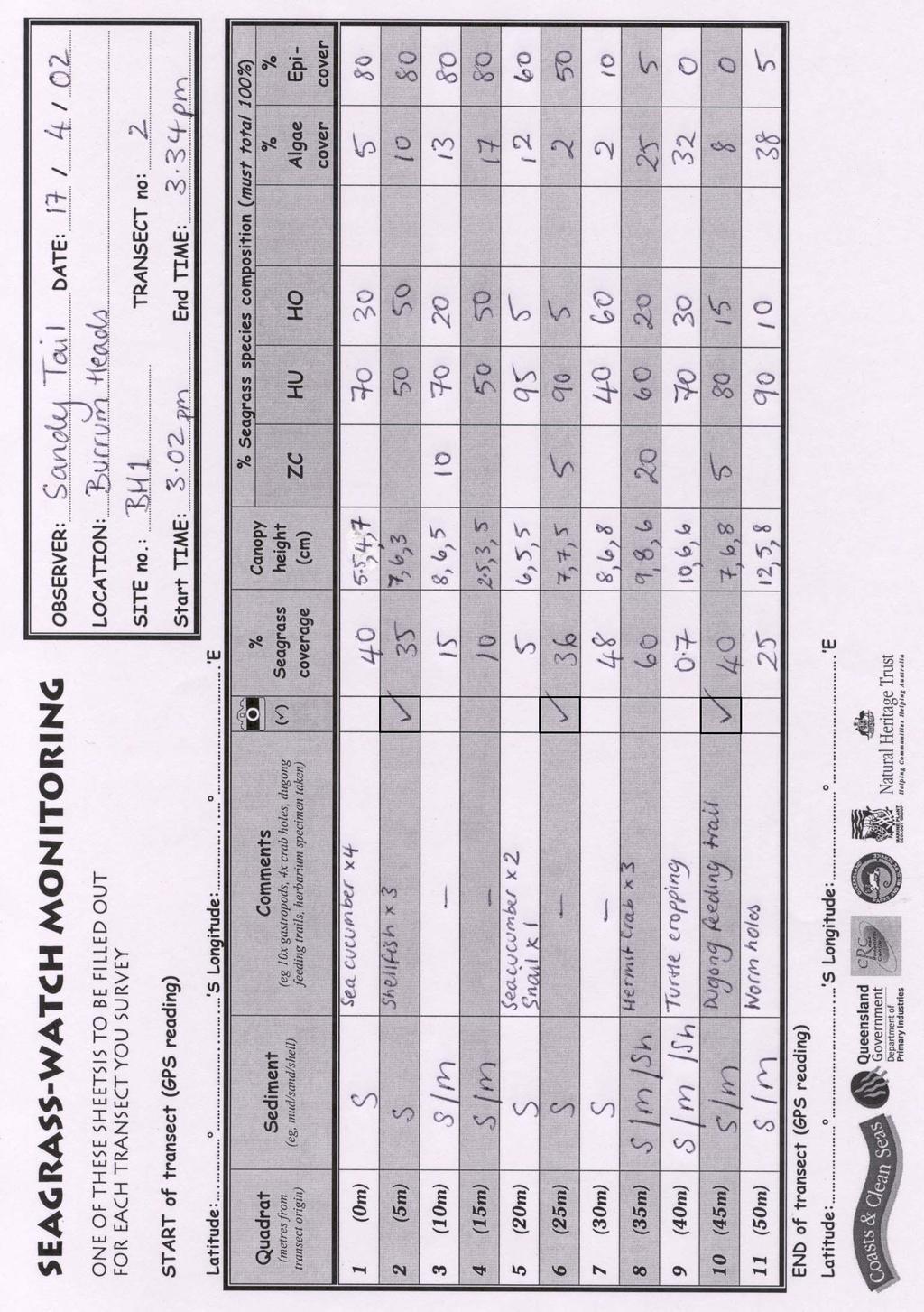
82
83 Manual for community (citizen) volunteers Appendix II Appendix II. Seagrass percent cover standards page 81


84 3% 3% 1% Percent cover standards 5% 3% 5% 7% 20% 7% 12% 45% 30% 15% 20% 55% 25% 20% 15% 45% 25% 45% 35% 55% 20%


85 3% 3% 18% Percent cover standards 5% 22% 25% 30% 20% 7% 35% 40% 45% 30% 15% 20% 55% 20% 15% 45% 45% 25% 45% 60% 35% 55% 20%


86 Percent cover standards 2% 12% 20% 30% 35% 55% 80% 75% 90%
87 2% Percent cover standards 12% 30% 35% 55% 75% 85 % 100 %


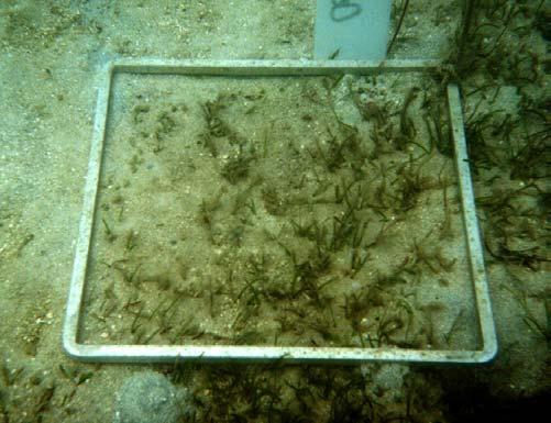
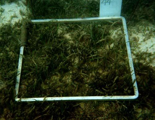
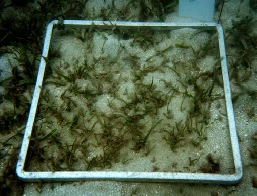
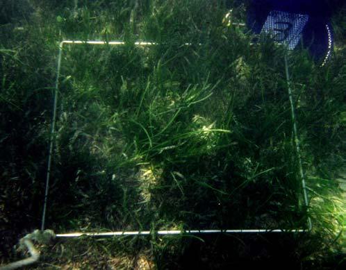
88 1 % Percent cover standards 10 % 25 % 35 % 35 % 75 % 80 % 100 %
89 Manual for community (citizen) volunteers Appendix III Appendix III.Seagrass identification sheets & key page 87


90 SEAGRASS SPECIES CODES ZC Zostera Syringodium SI isoe f ti o m liu caprico i Halophi a 5 longitudinal veins Cross veins Leaf grows straight from rhizome ie no shoot l rn HO ovalis Eight or more cross veins and no hairs of leaf surface Halophila Cylindrical in cross section, leaf tip tapers to a point spinulosa HS Fern like HU Halodule uninervis 1 central vein and trident leaf tip Usually pale rhizome, with clean black leaf scars Compiled by the Marine Plant Ecology Group, Northern Fisheries Centre CAIRNS, November 1999 CS Cymodocea serrulata Serrated leaf tip longitudinal veins Wide leaf blade (5-9mm wide)


91 SEAGRASS SPECIES CODES CR Cymodocea rotundata 7-15 veins Well developed leaf sheath Rounded leaf tip HM Halophila minor Less than 8 pairs of cross veins Small oval leaf blade HT Halophila tricostata Leaves with 3 veins 2-3 leaves at each node TH Thalassia hemprichii Short black bars of tannin cells on leaf Oblong -serrated leaves Leaves whorl around stem Found subtidally Compiled by the Marine Plant Ecology Group, Northern Fisheries Centre CAIRNS, June 2000 Thick rhizome with scars between shoots Sickle shaped leaves
92 Seagrass-Watch Key for Sterile Material of Queensland Seagrasses 1. Leaves petiolate or compound, or strap-shaped without a ligule (i.e. a tongue-like structure at the junction of leaf blade and sheath) (Hydrocharitaceae) 2 Leaves linear to strap-shaped and ligulate, neither petiolate nor compound 4 2. Leaves strap-shaped, neither compound nor petiolate 3 Leaves compound or petiolate Halophila A. Plants with erect lateral shoots bearing a number of leaves B Plants without erect, lateral shoots, but one pair of petiolate leaves at each rhizome node C B pairs of distichous leaflets on an erect lateral shoot, blade with dense serrated margin H. spinulosa 3 leaves per erect lateral shoot node; blade with sparse serrated margin H. tricostata C. Leaf blade longer than petiole; blade margin finely serrated, blade surface usually hairy H. decipiens Leaf blade normally shorter than petiole; blade margin entire, blade surface naked D D. Leaf blade oval to oblong, less than 5mm wide, cross veins up to ten pairs H. minor Leaf blade oval to elliptical, more than 5mm wide, cross veins more than 10 pairs H. ovalis 3. Rhizome more than 1cm in diameter, without scales, but covered with long black bristles (fibre strands); roots cord-like Enhalus acoroides Rhizome less than 0.5mm in diameter, covered with scales, but no fibrous bristles; root normal Thalassia hemprichii 4. Leaf blade more or less terete Syringodium isoetifolium Leaf blade linear, flat, not terete 5 5. Plants with elongated erect stem bearing terminal clustered leaves; rhizome stiff, woody; root stiff Thalassodendron ciliatum Plants with a short or no erect stem, bearing linear leaves; rhizome herbaceous; root fleshy 6 6. Rhizome bearing short erect stems; leaf sheath finally falling and leaving a clean scar, blade apex usually serrated or dentated; roots arising not in groups 7 Rhizome without erect stems; leaf sheath persistant, remaining as fibrous strands covering rhizomes; blade apex truncate, neither serrated nor dentated; roots arising in 2 distinct groups of 4-8 at each node Zostera capricornii 7. Leaf blade with 3 veins Halodule 8 Leaf blade with more than 7 veins Cymodocea 9 8. Leaf apex tridentate, with median tooth blunt and well developed lateral teeth H. uninervis Leaf apex more or less rounded, lateral teeth weak H. pinifolia 9. Leaf scars closed; blade apex rounded with no or weakly serated C. rotundata Leaf scars open; blade apex blunt with strongly to moderately serrated C. serrulata (Prepared by J Kuo, UWA, Apr. 94) page 90
93 Manual for community (citizen) volunteers Appendix IV Appendix IV.Algae percent cover standard & identification sheets page 91


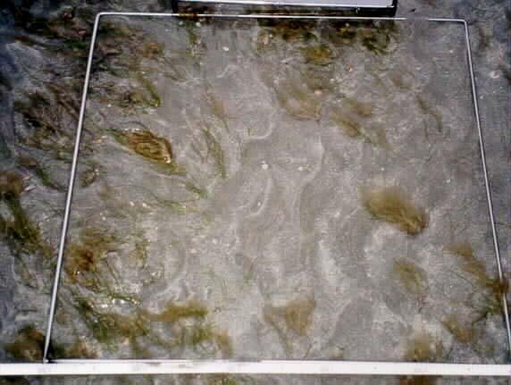
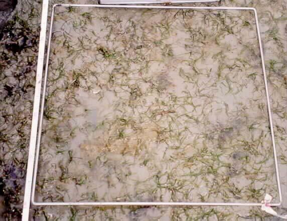
94 Algal percent cover standards 2% 5% 12% 15% 25% 40% 60% 85%


95 Algal percent cover standards 5% 12% 15% 30 % 40% 70%


 Laurencia sp.")
.")
96 Algal Identification Sheet Halimeda Spp Halimeda sp. Padina sp. Ceratodicton sp. in association with a sponge (Green Sponge) Digenea sp (worm weed) Laurencia sp. Laurencia sp Lyngbya Sargassum sp. Cited from Crib, A.b. (1996). Seaweeds of Queensland - A Naturalists Guide.


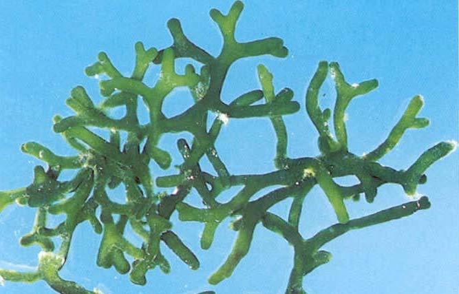
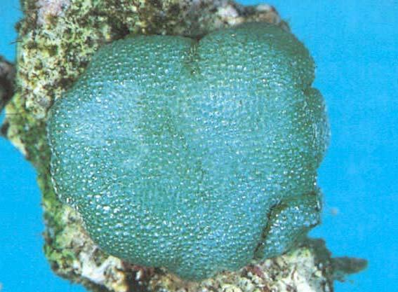
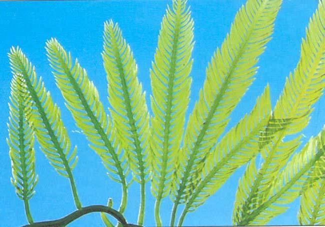
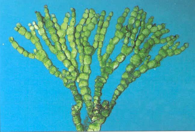
97 Algal Identification Sheet H. DISC-Halimedia sp H. CYL-H. cylindrica CAUL-Caulerpa sp DSPH-Dictyosphaeria sp. COD-Codium sp. COD.SP--Codium spongiosum BOE-Boergesenia sp. ULV-Ulva sp. Cited from Crib, A.b. (1996). Seaweeds of Queensland - A Naturalists Guide.


98 Algal Identification Sheet DICTY-Dictyota sp. PAD- Padina sp. TURB-Turbinara sp. CYS-Cystoseira sp. COLP-Colpomenia SAR-Sargassum sp. ACE-Acetabularia sp. NEO-Neomeris sp Cited from Crib, A.b. (1996). Seaweeds of Queensland - A Naturalists Guide.


99 Algal Identification Sheet JAN-Jania sp. ENC RED-Encrusting reds LAU-Laurencia sp. LAU- Laurencia sp. GS-Ceratodicton sp. in association with a green sponge DIG-Digenea sp. G.FIL-Green filamentous algae B.FIL- Brown filamentous algae Cited from Crib, A.b. (1996). Seaweeds of Queensland - A Naturalists Guide.
UMVERSITI MALAYSIA SABAW
 UMVERSITI MALAYSIA SABAW Community and Education-based monitoring sf seagrass in Sabah, Malaysia A workshop organized by Borneo Marine Research Institute, University of Malaysia, Sa ba h. in collaboration
Seagrass Surveys in Kampot
 Coastal Annual Forum 23 rd October 2014 Sihanoukville, Cambodia Seagrass Surveys in Kampot Presentation by Louis Bourne INTERNATIONAL UNION FOR CONSERVATION OF NATURE Presentation Overview Location and
Eastern Shore Islands Area of Interest Community Newsletter
 Eastern Shore Islands Area of Interest Community Newsletter Fall 2018 1ỊNTRODUCTION In addition to information on our Fisheries and Oceans Canada (DFO) website, we have now created a seasonal, community
Case Study 3. Case Study 3: Cebu Island, Philippines MPA Network 10
 Case studies of mpa networks Case Study 3: Cebu Island, Philippines MPA Network 10 Location and background Cebu Island in the Philippines lies in the center of the Visayan Islands, known as an area high
Habitat Fact Sheets. Rocky habitats are dominated by seaweeds and often mussels, which rely on the rocks for attachment.
 Habitat Fact Sheets Habitats in the Gulf of Maine serve many important roles for the environment and for humans as well. These include: cycling nutrients, filtering pollution, trapping sediments, storing
Seagrass-Watch Guidelines for Torres Strait Land & Sea Rangers
 Seagrass-Watch Guidelines for Torres Strait Land & Sea Rangers Port Kennedy Association Hall, Thursday Island 26 th February 2007 Len McKenzie & Jane Mellors Department of Primary Industries & Fisheries,
Seagrasses: Vital Habitat in Texas Estuaries
 Seagrasses: Vital Habitat in Texas Estuaries Cindy Hobson Water Resources Branch Coastal Fisheries Division Texas Parks and Wildlife Department February 17, 2015 Why Care About Seagrass? Sustain coastal
THE SEAGRASS LANDSCAPE OF BUNDAS MARINE PROTECTED AREA, BARANGAY BAGUMBAYAN, LUPON, DAVAO ORIENTAL, PHILIPPINES
 THE SEAGRASS LANDSCAPE OF BUNDAS MARINE PROTECTED AREA, BARANGAY BAGUMBAYAN, LUPON, DAVAO ORIENTAL, PHILIPPINES Presented by: Cirilo O. Ybaňez Jr. 1, Kris Vallerie A. Oñate 2 Davao Oriental of State College
Florida Seagrass Integrated Mapping and Monitoring Program
 Florida Seagrass Integrated Mapping and Monitoring Program - 2004 The following document is composed of excerpts taken from the 2011 publication, Seagrass Integrated Mapping and Monitoring for the State
dugon) ) and Seagrass in Thailand: Present Status and Future Challenges Kanjana Adulyanukosol Sombat Poovachiranon Mickmin Charuchida
 ) and Seagrass in Thailand: Present Status and Future Challenges Kanjana Adulyanukosol Sombat Poovachiranon Mickmin Charuchida") Dugong ( (Dugong dugon) ) and Seagrass in Thailand: Present Status and Future Challenges Kanjana Adulyanukosol Sombat Poovachiranon Mickmin Charuchida Phuket Marine Biological Center (PMBC) Department
Dugong ( (Dugong dugon) ) and Seagrass in Thailand: Present Status and Future Challenges Kanjana Adulyanukosol Sombat Poovachiranon Mickmin Charuchida Phuket Marine Biological Center (PMBC) Department
Oceanic Society Reef Research Team: Nicole Crane, Avigdor Abelson, Peter Nelson, Giacomo Bernardi, Michelle Paddack, Kate Crosman
 The coral reef of Tamil (Yap, FSM): Preliminary ecological assessment of reef state and fish assemblages, and potential of conservation for sustainable use Report compiled by vigdor belson, Peter Nelson
Seagrass habitat of Cairns Harbour and Trinity Inlet: December 2001
 Information Series QI02059 Seagrass habitat of Cairns Harbour and Trinity Inlet: December 2001 Campbell, S.J., Rasheed, M.A. and Thomas, R. Marine Plant Ecology Group Northern Fisheries Centre Queensland
CHAPTER 11.1 THE WORLD OCEAN MARINE BIOMES NOTES
 CHAPTER 11.1 THE WORLD OCEAN MARINE BIOMES NOTES 1. The world ocean can be divided into zones both and. The,, and zones that apply to large lakes also apply to the ocean. 2. In addition to the depth zones,
Policy Instruments for Fisheries Management and the Concept of Fisheries Refugia
 REVERSING ENVIRONMENTAL DEGRADATION TRENDS Policy Instruments for Fisheries Management and the Concept of Fisheries Refugia Christopher Paterson, UNEP/GEF South China Sea Project REVERSING ENVIRONMENTAL
SA New Trial Artificial Reef Project
 BACKGROUND PAPER SA New Trial Artificial Reef Project Development of options for the trial artificial reef 1. Summary CONTENTS Each year, an estimated 236,000 South Australians participate in recreational
Significant Ecological Marine Area Assessment Sheet
 Significant Ecological arine Area Assessment Sheet Name: ouhora arbour arine Values Summary: The entrance subtidal channel, tidal flats, seagrass mangrove and saltmarsh habitats of ouhora arbour have given
Salmon Five Point Approach restoring salmon in England
 Salmon Five Point Approach restoring salmon in England Our Mission To restore the abundance, diversity and resilience of salmon stocks throughout England We will do this by:- a) Maximising the production
Review of the current impacts of Dredge Spoil Islands and water circulation on adjacent seagrass beds Swansea Flats
 Office of the Lake Macquarie and Catchment Co-ordinator Review of the current impacts of Dredge Spoil Islands and water circulation on adjacent seagrass beds Swansea Flats March 2004 TABLE OF CONTENTS
SEAGRASS MAPPING FOR THE PENRHYN ESTUARY HABITAT ENHANCEMENT PLAN
 SEAGRASS MAPPING FOR THE PENRHYN ESTUARY HABITAT ENHANCEMENT PLAN PREPARED FOR SYDNEY PORTS CORPORATION By D. E. Roberts, S. R. Murray, G. R., Sainty August 2008 TABLE OF CONTENTS INTRODUCTION...3 METHODS...3
Overview. What are Corals?
 Overview Coral Reefs extend back over 500 m.y. Grow in tropical seas with normal salinity Support a great variety of plant and animal life Cover less than 0.2% of sea floor Contain about 25% of marine
Seagrass-Watch. Activity Book. Junior Edition
 Seagrass-Watch Activity Book Junior Edition Sensational Seagrass Seagrass are flowering plants that live in the sea. There are many different kinds of seagrasses and some do not look like grass at all.
Marine Conservation and Research Expedition Training, Examination and Certification Summary
 Marine Conservation and Research Expedition Training, Examination and Certification Summary Introduction This document summarizes the current training schedule and materials being used at the two Marine
SALINITY. It's the amount of dissolved salts the water contains.
 AQUATIC ECOSYSTEMS SALINITY The types of organisms in an aquatic ecosystem depend upon the water s Salinity. It's the amount of dissolved salts the water contains. Salinity determines the two main aquatic
Port Curtis and Rodds Bay seagrass and benthic macro-invertebrate community baseline survey
 INFORMATION SERIES QI03058 Port Curtis and Rodds Bay seagrass and benthic macro-invertebrate community baseline survey November/December 2002 M A Rasheed R Thomas A J Roelofs K M Neil and S P Kerville
Dr. Kim Peyton. (w/ some modifications by Dr. Bruland) University of Hawai i Mānoa
 University of Hawai i Mānoa") The Seagrasses Dr. Kim Peyton (w/ some modifications by Dr. Bruland) University of Hawai i Mānoa Department t of Botany 1 Outline Anatomy Characteristics Taxonomy, systematics, &evolution Distribution
The Seagrasses Dr. Kim Peyton (w/ some modifications by Dr. Bruland) University of Hawai i Mānoa Department t of Botany 1 Outline Anatomy Characteristics Taxonomy, systematics, &evolution Distribution
Trawl fishery management of Eastern Arabian Sea
 Trawl fishery management of Eastern Arabian Sea Dr. A.P.Dineshbabu, Central Marine Fisheries Research Institute, India Existing management practices Seasonal closure of fishery: The regulations for closed
Marine Ecosystems. Aquatic Ecosystems Section 2
 Marine Ecosystems Marine ecosystems are located mainly in coastal areas and in the open ocean. Organisms that live in coastal areas adapt to changes in water level and salinity. Organisms that live in
Update on Columbia Basin Partnership Task Force
 Update on Columbia Basin Partnership Task Force June 25, 2018 Marla Harrison Port of Portland M A F A C C B P T A S K F O R C E Overview of Today s Presentation: Background on Columbia Basin & why we need
Examples of estuaries include bays, sounds, salt marshes, mangrove forests, mud flats, swamps, inlets, and sloughs.
 An estuary is a partially enclosed body of water where incoming seawater is mixed with fresh water coming from the land. Examples of estuaries include bays, sounds, salt marshes, mangrove forests, mud
Submission on summary of the Draft Convention on Biological Diversity National Report
 23 November 2018 Submission on summary of the Draft Convention on Biological Diversity National Report The New Zealand Marine Sciences Society (NZMSS) is a professional society affiliated to the Royal
Oceans Humans both depend on it and threaten it with their activities
 Oceans Humans both depend on it and threaten it with their activities Oceans Water covers nearly ¾ of the Earth s surface More than 50% of the world s population lives within an hour of the coast Oceans
Warm-up # 7 A day 5/17 - B day 5/18 UPDATE YOUR TABLE OF CONTENTS
 Warm-up # 7 A day 5/17 - B day 5/18 UPDATE YOUR TABLE OF CONTENTS Question: List all examples of surface water on Earth. Answer: Rivers and streams, lakes and reservoirs, (ponds) wetlands, estuaries and
Technical and Financial Proposal
 Technical and Financial Proposal Marine Survey of Montego Bay Marine Park Assessment of Reef Health for Management Recommendations Dayne Buddo Ph.D. Marine Ecologist April 24, 2014. Marine Survey Montego
Planning for tennis in your Local Government Area. A resource from Tennis Australia
 Planning for tennis in your Local Government Area A resource from Tennis Australia Part 1 July 2016 ABOUT THIS RESOURCE This resource forms part of Tennis Australia's Local Government Engagement Program.
LK Increasing knowledge on sea grass habitats and dugong distribution at selected sites in North Western Sri Lanka Project progress July2016
 LK6-2132 Increasing knowledge on sea grass habitats and dugong distribution at selected sites in North Western Sri Lanka Project progress July2016 ORCA Ocean Resources Conservation Association This is
Sample page. Contents
 Contents Part A: Mangroves and seagrasses 5 A1. What do mangroves look like? 5 A2. Which animals use mangroves for shelter? 7 A3. How do mangroves grow? 8 A4. How do mangroves reproduce? 10 A5. Which animals
Version: 1.0 Last amendment: 16/01/2012. Contact Officer: Animal Welfare Officer
 CDU AEC Policy on the Collection of Voucher Specimens : 1.0 Last amendment: 16/01/2012 Contact Officer: Animal Welfare Officer Approved By: CDU AEC Date: January 2012 Next Review: January 2014 INTRODUCTION
WHALE SHARK (Rhincodon typus) RECOVERY PLAN
 RECOVERY PLAN") WHALE SHARK (Rhincodon typus) RECOVERY PLAN 2004-2009 Great Barrier Reef Marine Park Authority Background The whale shark (Rhincodon typus) is the world s largest fish, and one of only 3 filter-feeding
WHALE SHARK (Rhincodon typus) RECOVERY PLAN 2004-2009 Great Barrier Reef Marine Park Authority Background The whale shark (Rhincodon typus) is the world s largest fish, and one of only 3 filter-feeding
THE WILDLIFE CONSERVATION AND MANAGEMENT ACT. (No. 47 of 2013)
") THE WILDLIFE CONSERVATION AND MANAGEMENT ACT (No. 47 of 2013) IN EXERCISE of the powers conferred by section 109(4) (b) of the Wildlife Conservation and Management Act, 2013, the Cabinet Secretary for
THE WILDLIFE CONSERVATION AND MANAGEMENT ACT (No. 47 of 2013) IN EXERCISE of the powers conferred by section 109(4) (b) of the Wildlife Conservation and Management Act, 2013, the Cabinet Secretary for
Fishery Improvement Projects
 Fishery Improvement Projects What is a Fishery Improvement Project (FIP)? A FIP is an alliance of stakeholders retailers, processors, producers, and/or catchers that comes together to resolve problems
Certification Determination. Louisiana Blue Crab Commercial Fishery
 15 th November 2016 Certification Determination For The Louisiana Blue Crab Commercial Fishery Following a meeting of a Global Trust Certification Committee on 20 th October 2016, a positive determination
Eelgrass Survey PARADISE CAY BELVEDERE, MARIN COUNTY CALIFORNIA. Prepared For:
 Eelgrass Survey PARADISE CAY BELVEDERE, MARIN COUNTY CALIFORNIA Prepared For: Radford (Skid) Hall, Ph.D. Land Planning and Permitting Consultant 500 Airport Blvd., Suite 350 Burlingame, CA 94010 (650)
Restoration of Eelgrass to Upper Casco Bay: Feasibility Tests in Hilary A. Neckles US Geological Survey Augusta, ME
 Restoration of Eelgrass to Upper Casco Bay: Feasibility Tests in 2015 Hilary A. Neckles US Geological Survey Augusta, ME hneckles@usgs.gov Robert J. Orth Eelgrass: Zostera marina * marine flowering plant
Results of a Suspended Solids Survey at the Whites Point Quarry, Little River, Digby County, Nova Scotia
 Results of a Suspended Solids Survey at the Whites Point Quarry, Little River, Digby County, Nova Scotia Prepared for Global Quarry Products P.O. Box 2113 Digby, Nova Scotia B0V 1A0 By Michael Brylinsky
Falmouth and St.Austell pspa bird bycatch analysis report year
 Natural England Commissioned Report NECR231 Falmouth and St.Austell pspa bird bycatch analysis report year 1-2014 First published 20 April 2017 www.gov.uk/natural-england Foreword Natural England commission
Annual Measurement of Solar UVB at a Reef Site Using a Polyphenylene Oxide Dosimeter
 Annual Measurement of Solar UVB at a Reef Site Using a Polyphenylene Oxide Dosimeter Alfio Parisi, Nathan Downs, Peter Schouten parisi@usq.edu.au University of Southern Queensland, Toowoomba, Australia
Killingly Public Schools
 Grade 11 Draft: Jan. 2005 Killingly Public Schools Aquaculture/Natural Resources III Tilapia Production CONTENT STANDARD 11 AQ III 1: The students will understand the origin of Tilapia culture, the worldwide
Use of Conservation Moorings as a Component of Eelgrass Restoration in two Massachusetts Harbors
 Use of Conservation Moorings as a Component of Eelgrass Restoration in two Massachusetts Harbors Massachusetts Bays Program Division of Marine Fisheries Jay Baker, Tay Evans, Mass Bays Program MarineFisheries
Seagrass: Global Conservation Challenges
 Seagrass: Global Conservation Challenges Len McKenzie 1 & Richard Unsworth 2 1 James Cook University, Cairns, Queensland, Australia 2 Swansea University, Swansea, Wales, United Kingdom photo courtesy Ria
Reef Check Australia. Magnetic Island Season Report 2016
 Reef Check Australia Season Report 16 Reef Check Foundation Ltd. (Australia) www.reefcheckaustralia.org PO Box 134 George St Brisbane QLD 43 This report should be cited as: M. Welch, J. Salmond and J.
The Maritime Law Association of Australia and New Zealand
 The Maritime Law Association of Australia and New Zealand Protecting the Environment and Promoting Safe Navigation: Australia s System of Pilotage in the Torres Strait Adam McCarthy Assistant Secretary
Chagrin River TMDL Appendices. Appendix F
 Appendix F The following are excerpts from the Eastern Brook Trout Joint Venture s Conservation Strategy (Working Draft v.6), Conserving the Eastern Brook Trout: Strategies for Action Found at: http://www.easternbrooktrout.org/constrategy.html
Protect Our Reefs Grant Interim Report (October 1, 2008 March 31, 2009) Principal investigators: Donald C. Behringer and Mark J.
 Principal investigators: Donald C. Behringer and Mark J.") Investigating the role of the spotted spiny lobster (Panulirus guttatus) in the recovery of the long spined sea urchin (Diadema antillarum) on the coral reefs of the Florida Keys Protect Our Reefs Grant
Investigating the role of the spotted spiny lobster (Panulirus guttatus) in the recovery of the long spined sea urchin (Diadema antillarum) on the coral reefs of the Florida Keys Protect Our Reefs Grant
Organising the National Technology Needs Assessment (TNA) Process: An Explanatory Note
 Process: An Explanatory Note") Appendix II Organising the National Technology Needs Assessment (TNA) Process: An Explanatory Note Subash Dhar, Jyoti Painuly, Ivan Nygaard and Jorge Rogat UNEP DTU Partnership (UDP) Denmark Revised (November,
Appendix II Organising the National Technology Needs Assessment (TNA) Process: An Explanatory Note Subash Dhar, Jyoti Painuly, Ivan Nygaard and Jorge Rogat UNEP DTU Partnership (UDP) Denmark Revised (November,
2016 West Coast Entanglement Summary
 March 2017 2016 West Coast Entanglement Summary Overview of Entanglement Data west coast region MMHSRP Permit #18786 In 2016, 71 separate cases of entangled whales were reported off the coasts of Washington,
Fishery Improvement Projects
 Fishery Improvement Projects What is a Fishery Improvement Project? A FIP is an alliance of stakeholders retailers, processors, producers and catchers that comes together to resolve problems within a specific
CenSeam developing a global baseline and synthesis of seamount biodiversity data. Malcolm Clark, Ash Rowden, Karen Stocks, Mireille Consalvey
 CenSeam developing a global baseline and synthesis of seamount biodiversity data Malcolm Clark, Ash Rowden, Karen Stocks, Mireille Consalvey This afternoon General introduction to seamounts and the CenSeam
BASELINE SURVEY, VISUAL - SITE SPECIFIC
 BASELINE SURVEY, VISUAL - SITE SPECIFIC Introduction As stated in SEPA s policy and in the Fish Farm Manual (1998), scientific data are required by SEPA in order to assess the existing condition on the
Information Paper for SAN (CI-4) Identifying the Spatial Stock Structure of Tropical Pacific Tuna Stocks
 Identifying the Spatial Stock Structure of Tropical Pacific Tuna Stocks") Current knowledge, key uncertainties and future research directions for defining the stock structure of skipjack, yellowfin, bigeye and South Pacific albacore tunas in the Pacific Ocean Information Paper
Current knowledge, key uncertainties and future research directions for defining the stock structure of skipjack, yellowfin, bigeye and South Pacific albacore tunas in the Pacific Ocean Information Paper
Thank you for the opportunity to comment on the Draft Freshwater Fisheries Management Plan on behalf of Victoria s recreational fishing sector.
 Anthony Forster Inland Fisheries Manager Victorian Fisheries Authority By email: Anthony.Forster@vfa.vic.gov.au DRAFT FRESHWATER FISHERIES MANAGEMENT PLAN Dear Anthony, Thank you for the opportunity to
Today: Coastal Issues and Estuaries
 Today: Coastal Issues and Estuaries Coastal issues Human effect on coastlines What is an estuary Why are they so important? Circulation of water in estuary Environmental issues Coastal Issues: Problem
SARASOTA BAY ESTUARY PROGRAM OYSTER HABITAT MONITORING RESULTS: YEAR 1. Jay R. Leverone
 SARASOTA BAY ESTUARY PROGRAM OYSTER HABITAT MONITORING RESULTS: YEAR 1 by Jay R. Leverone Mote Marine Laboratory 1600 Ken Thompson Parkway Sarasota, Fl 34236 to Gary Raulerson Sarasota Bay Estuary Program
Three Rivers Cockle Abundance Survey Report April 2016
 Three Rivers Cockle Abundance Survey Report April 16 May 16 Crown Copyright WG 2884 ISBN digital 978-1-4734-669-6 1. Introduction The annual Three Rivers Estuaries cockle abundance survey was conducted
Puget Sound Shorelines. Waves and coastal processes. Puget Sound shorelines: Effects of beach armoring
 Puget Sound Shorelines Puget Sound shorelines: Effects of beach armoring Waves and coastal processes Factors affecting wave energy hitting the coast Processes transporting sediment along coastlines What
Lesson 10: Oyster Reefs and Their Inhabitants
 Lesson 10: Oyster Reefs and Their Inhabitants Focus Question: What animals use oyster reefs for habitats? Objective: observe properties of animals found within a bag of oysters; Infer about the quality
University of Miami Rosenstiel School of Marine and Atmospheric Science. Billfish Research Program
 University of Miami Rosenstiel School of Marine and Atmospheric Science Billfish Research Program 2011-2013 UNIVERSITY OF MIAMI Billfish Science Laboratory: RESEARCH FOCUS Uses advanced remote sensing
Seagrasses of the Virgin Islands
 Seagrasses of the Virgin Islands Seagrasses are flowering plants that live underwater. These marine plants resemble the land species of grasses in that they have long blade-like leaves. Seagrasses grow
Subtidal and intertidal restored reefs in North Carolina
 Subtidal and intertidal restored reefs in North Carolina Jonathan H. Grabowski 1, Sean P. Powers 2, Pete Peterson 3, and Hunter S. Lenihan 4 1 Gulf of Maine Research Institute/U. Maine-Darling Marine Center
Orange County MPA Watch A n n u a l R e p o r t
 Orange County MPA Watch 2 0 1 4 A n n u a l R e p o r t WHAT IS AN MPA? Marine Protected Areas (MPAs) are discrete geographic marine or estuarine areas designed to protect or conserve marine life and habitat.
Characterising the status of the Western Port recreational fishery in relation to biodiversity values: Phase 1 Greg Jenkins and Simon Conron
 Characterising the status of the Western Port recreational fishery in relation to biodiversity values: Phase 1 Greg Jenkins and Simon Conron November 2015 1 Contents Executive Summary... 7 Introduction...
Refined Designated Uses for the Chesapeake Bay and Tidal Tributaries
 A-1 appendixa Refined Designated Uses for the Chesapeake Bay and Tidal Tributaries BACKGROUND Federal water quality standards regulations establish that states must specify appropriate water uses to be
Tips for trainers. Participatory quota setting
 Participatory quota setting The Tips for Trainers for this issue are taken from a publication called District Quota Setting Toolbox, part of the World Wide Fund for Nature (WWF) Wildlife Management Series.
Repeat Monitoring of Seagrass Beds for Project Next Generation Autumn 2016
 Repeat Monitoring of Seagrass Beds for Project Next Generation Autumn 2016 Prepared by April 2016 Project Next Generation: Repeat Seagrass Monitoring: Autumn 2016 1 Repeat Monitoring of Seagrass Beds for
Fisheries Management Standard. Version 2.0
 Enacted in Japanese: 2017.10.03 Effective in Japanese: 2018.02.01 Fisheries Management Standard Version 2.0 Marine Eco-Label Japan Council (2018) Introduction Marine Eco-Label Japan (MEL) Council have
Welsh Waters Scallop Strategy 28 th May Summary of research
 Welsh Waters Scallop Strategy 28 th May 2013 Summary of research Introduction This document describes the scallop research being conducted by Bangor University s Fisheries & Conservation Science Group
Summary of Preliminary Results of Transboundary Diagnostic Analysis, 2018
 1 Western And Central Pacific Oceanic Fisheries Management Summary of Preliminary Results of Transboundary Diagnostic Analysis, 2018 Fact sheet for the Oceanic Fisheries Management Project (OFMP2). OFMP2
West Coast Rock Lobster. Description of sector. History of the fishery: Catch history
 West Coast Rock Lobster Description of sector History of the fishery: The commercial harvesting of West Coast rock lobster commenced in the late 1800s, and peaked in the early 1950s, yielding an annual
WHAT ARE ECOSYSTEMS? Dr. V. N. Nayak Professor of Marine Biology (Retd)
") WHAT ARE ECOSYSTEMS? Dr. V. N. Nayak Professor of Marine Biology (Retd) An ECOSYSTEM is an interacting system of plant, animals, and humans and the surrounding environment. An ecosystem contains living
WHAT ARE ECOSYSTEMS? Dr. V. N. Nayak Professor of Marine Biology (Retd) An ECOSYSTEM is an interacting system of plant, animals, and humans and the surrounding environment. An ecosystem contains living
EXECUTIVE SUMMARY. Argyll Marine Special Areas of Conservation
 Argyll Marine Special Areas of Conservation Legislative Background Under the Habitats Directive (Council Directive 92/43/EEC on the conservation of natural habitats and of wild fauna and flora), Loch Creran
Texas Water Resources Institute
 Texas Water Resources Institute November/December 1982 Volume 8 No. 6 A Precise Environment By Lou Ellen Ruesink, Editor, Texas Water Resources Aquarium enthusiasts know just how particular fish are about
Into the Al Hajar with the Arabian Tahr 2012 FIELD REPORT
 Into the Al Hajar with the Arabian Tahr 2012 FIELD REPORT Background Information Lead PI: Dr Steve Ross Report completed by: Steve Ross, Mansoor Al Jahdhami, Debbie Winton Period Covered by this report:
Maryland Chapter Trout Unlimited Brook Trout Conservation Effort
 Maryland Chapter Trout Unlimited Brook Trout Conservation Effort Photo by Matt Kline Portfolio of Recent Work MDTU Brook Trout Conservation Coordinator: Scott C. Scarfone, ASLA sscarfone@oasisdesigngroup.com
NASCO Guidelines for the Management of Salmon Fisheries
 NASCO Guidelines for the Management of Salmon Fisheries NASCO Guidelines for the Management of Salmon Fisheries Additional copies of these Guidelines can be obtained free of charge from: The Secretary
GCSE GEOGRAPHY YR 11 KNOWLEDGE BOOK FIELDWORK
 GCSE GEOGRAPHY YR 11 KNOWLEDGE BOOK FIELDWORK PHYSICAL STUDY Page 1 PHYSICAL STUDY: HARD ENGINEERING IS CONTROLLING LONGSHORE DRIFT AT SHERINGHAM The information here is what students MUST know. If you
EVALUATING THE EFFECTS OF BIVALVE SHELLFISH AQUACULTURE AND ITS ECOLOGICAL ROLE IN THE ESTUARINE ENVIRONMENT IN THE UNITED STATES
 EVALUATING THE EFFECTS OF BIVALVE SHELLFISH AQUACULTURE AND ITS ECOLOGICAL ROLE IN THE ESTUARINE ENVIRONMENT IN THE UNITED STATES Brett Dumbauld USDA Agricultural Research Service, Hatfield Marine Science
USING BIOLOGICALLY IMPORTANT PHYSICAL CHARACTERISTICS OF ESTUARIES TO CLASSIFY AUSTRALIAN AND NEW ZEALAND ESTUARIES
 USING BIOLOGICALLY IMPORTANT PHYSICAL CHARACTERISTICS OF ESTUARIES TO CLASSIFY AUSTRALIAN AND NEW ZEALAND ESTUARIES Michael Whelan, Southern Cross University, Australia. Peter Saenger, Southern Cross University,
Blue cod 5 (BCO5) pot mesh size review
 pot mesh size review") Blue cod 5 (BCO5) pot mesh size review Discussion Document MPI Discussion Paper No: 2017/01 Prepared for public consultation by the Ministry for Primary Industries ISBN No: 978-1-77665-454-3 (o) ISSN No:
Blue cod 5 (BCO5) pot mesh size review Discussion Document MPI Discussion Paper No: 2017/01 Prepared for public consultation by the Ministry for Primary Industries ISBN No: 978-1-77665-454-3 (o) ISSN No:
The Orkney Creel Fishery
 The Orkney Creel Fishery Fishery Improvement Project Work Plan Michael Bell, Kate Walker 2/21/2013 Introduction This work plan has been developed as part of the Fishery Improvement Project (FIP) of the
Risk Assessments in the Pacific Fisheries for BC & Yukon
 Risk Assessments in the Pacific Fisheries for BC & Yukon MARCH, 2017 CONTENTS Introduction to Risk Assessments... 2 Q&As on the Risk Assessment Process... 3 Overview of the Risk Assessment Tool... 4 Example
Lecture Outlines PowerPoint. Chapter 15 Earth Science, 12e Tarbuck/Lutgens
 Lecture Outlines PowerPoint Chapter 15 Earth Science, 12e Tarbuck/Lutgens 2009 Pearson Prentice Hall This work is protected by United States copyright laws and is provided solely for the use of instructors
Appendix Template for Submission of Scientific Information To Describe Ecologically or Biologically Significant Marine Areas
 Appendix Template for Submission of Scientific Information To Describe Ecologically or Biologically Significant Marine Areas Abstract (in less than 150 words) Coastal and marine areas: Africa Somalia has
Fisheries Management Zone 10:
 Fisheries Management Zone 10: Lake Trout Operational Objectives and Management Photo Credit: www.jamessmedleyoutdoors.com 2 FMZ 10: Lake Trout Operational Objectives and Management Lake trout are the second
Types of Freshwater Ecosystems. Streams originate from underground water. Rivers form when streams join together. Freshwater Biome
 Definition Streams originate from underground water sources Types of Freshwater Ecosystems Streams Rivers Rivers form when streams join together Freshwater Lakes Ponds Basic Characteristics Directional
Natural Bridges Field Trip Activity
 Natural Bridges Field Trip Activity This is due in class on MONDAY- March 1 - not in sections! Name TA: NOTE ON THE GRADING OF THIS ASSIGNMENT: Many of the questions below (especially in the tidepool part)
The Sustainability of Atlantic Salmon (Salmo salar L.) in South West England
 in South West England") The Sustainability of Atlantic Salmon (Salmo salar L.) in South West England Submitted by Sarah-Louise Counter to the University of Exeter as a thesis for the degree of Doctor of Philosophy in Biological
The Sustainability of Atlantic Salmon (Salmo salar L.) in South West England Submitted by Sarah-Louise Counter to the University of Exeter as a thesis for the degree of Doctor of Philosophy in Biological
SEASFIRE Introduction explore discover create
 SEASFiRE MX2 March 2018 2 SEASFIRE Introduction SEASFiRE organizes citizen science, marine education, and adventure programs which enable you to explore nature, discover the world around you, and create
Management advisory for the Bay of Bengal hilsa fishery June 2012
 Page1 Management advisory for the Bay of Bengal hilsa fishery June 2012 What is the BOBLME RFMAC The BOBLME Project is supporting countries to implement an ecosystem approach to fisheries management of
Pre Feasibility Study Report Citiwater Cleveland Bay Purification Plant
 SOLAR POWER SPECIALISTS.Pure Power ACN 074 127 718 ABN 85 074 127 718 POWER MAGIC PTY LTD 245 INGHAM RD GARBUTT QLD 4814 Phone: 1800 068 977 Fax: 07 4725 2479 Email: FNQSOLAR@bigpond.com Pre Feasibility
SEAGRASS SURVEY CALATAGAN
 SEAGRASS SURVEY CALATAGAN Conducted with the sponsorship of the CAP Oceans Foundation Angela Quiros, PH.D Candidate University of California Santa Cruz and Cori Hume, Leslie Hart, Ian Jacobson, Jordan
Indian River Lagoon: Lessons, Challenges and Opportunities
 Indian River Lagoon: Lessons, Challenges and Opportunities Upper Chain of Lakes Lake Kissimmee Kissimmee River Indian River Lagoon Caloosahatchee Estuary Lake Okeechobee St. Lucie Estuary Mark Perry, Executive