AIRPORT RD. EROSION HOMEOWNER FOCUS GROUP SUMMARY 1/1/ PM NATURE COAST BIOLOGICAL STATION
|
|
|
- Spencer Singleton
- 5 years ago
- Views:
Transcription
1 AIRPORT RD. EROSION HOMEOWNER FOCUS GROUP SUMMARY 1/1/ PM NATURE COAST BIOLOGICAL STATION This workshop was the fourth in a series of workshops about coastal erosion in Cedar Key hosted by the University of Florida. The goal of the workshop series was to introduce property owners to various concepts regarding erosion in Cedar Key s Daughtry Bayou, including the history of erosion, impacts of erosion, and potential ways to mitigate erosion. The objectives of the meeting series were as follows: Workshop 1: Coastal Erosion Visioning Workshop, 3/3/2017 o Discuss erosion history in the area and preferences for shoreline uses o Learn more about and compare various options for erosion control o Narrow down a range of acceptable project types that promise to preserve the shoreline at G Street and Airport Rd. locations, according to preferred uses. Workshop 2: G Street Design Workshop, 10/27/2017 o Review workshop 1 process & outcomes o Answer questions that stakeholders raised at workshop 1 o Present designs based on preferences from workshop 1, discuss specifics for further refinement o Come to agreement on best design option for follow up funding & implementation at G Street Workshop 3: Airport Rd. Design Workshop, 11/3/2017 o Review workshop 1 process & outcomes o Answer questions that stakeholders raised at workshop 1 o Present designs based on preferences from workshop 1, discuss specifics for further refinement o Come to agreement on best design option for follow up funding & implementation at Airport Rd. Workshop 4: Airport Rd. Homeowner Focus Group, 1/11/2018 o Review the rationale and progress of the coastal erosion workshop series for those new to the process o Discuss and evaluate specific project designs and build consensus around one preferred option o Clarify next steps and timeline The Airport Rd. Focus Group was attended by 19 participants and 3 project staff. The majority of the attendees were property owners on Airport Road but we also had representation from City and County government as well as residents of areas adjacent to Airport Rd. Project team members in attendance: Savanna Barry UF IFAS Nature Coast Biological Station Mark Clark UF IFAS Soil and Water Science Department Scott Wasman UF College of Engineering
2 Workshop Agenda: AIRPORT ROAD DESIGN WORKSHOP STAKEHOLDER INPUT ON OPTIONS FOR EROSION CONTROL IN CEDAR KEY 6pm 8pm, Jan 11, 2018, UF IFAS Nature Coast Biological Station Local Contact = Savanna Barry, UF/IFAS Extension Sea Grant Cell: AGENDA 6:00 PM 6:15 PM Welcome, Introductions, and Agenda Review 6:15 PM 7:00 PM Project Background Shoreline Erosion, Range of Erosion Control Options, Specific Project Ideas for Airport Rd. 7:00 PM 7:45 PM Discussion and Q&A of Project Options 7:45 PM 8:00 PM Wrap Up and Next Steps The workshop began with a review of the agenda and objectives for workshop 4 to orient participants to the goals for the meeting. There was a show of hands to determine who was new to the process and who had been involved in previous workshops in the series. About 50% of people raise their hands to indicate they were new to the process. The group also reviewed the list of next steps that had been identified at the Nov 3 rd meeting and listed how each item is being or will be addressed. List of Next Steps: 1. Contact DEP re: mangrove management Status: In progress, DEP has issued a verbal statement that they would consider a permit condition that would allow mechanical removal of mangroves from within the footprint of a living shoreline project. 2. Invite DEP to give a local workshop Status: Complete DEP will be giving a free open house event to discuss mangroves, living shorelines, recycling, water, and other local environmental issues from 10 am 12 pm at the Nature Coast Biological Station on Feb 22 nd 3. Meet with Airport Road Landowners Status: completed 1/11/2018 (this meeting) 4. Rework Airport Rd. Project Designs and bring RipRap back for discussion Status: completed 1/11/2018 (this meeting) 5. Follow-up meeting after Landowner Meeting status: Scheduled for 3/29/2018, 9 am to 12:30 PM at the Cedar Key Community Center 6. Seek funding for phase 4 option if landowners agree status: in progress After the next steps were reviewed, Dr. Mark Clark presented background information on erosion control options, the specific need for erosion control in Daughtry Bayou, and the design options for Airport Rd. (See below for copies of the presentations). Each design was presented in detail and Mark made some comments regarding the function of each project element. Participants had scoring sheets and wrote down comments during the presentation.
, longevity, cost (construction and maintenance), and")
 while Savanna recorded the questions and discussion points.")
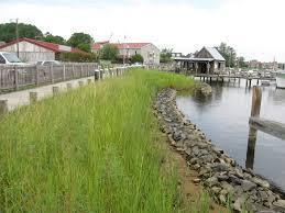
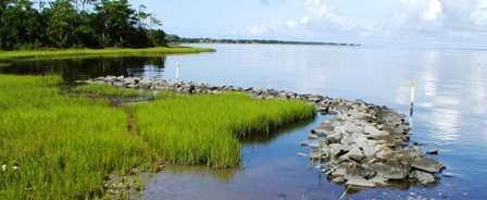
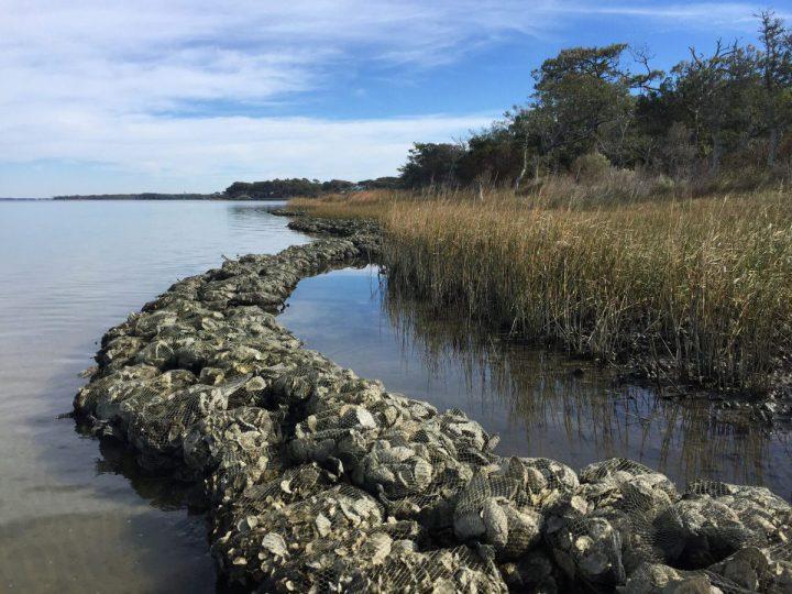
3 Mark then presented the expert scorecard for each design. The scorecard showed the grades for categories such as environmental services (habitat, wave dissipation, carbon sequestration, and water quality), longevity, cost (construction and maintenance), and likelihood of obtaining external funding. (See Appendix for copies of the design options and scorecards). After all of the designs were presented, participants discussed the options and asked questions of the experts (Scott and Mark) while Savanna recorded the questions and discussion points. Questions/comments about RipRap (above) included: - a question about whether or not mangroves could be removed from this option the answer was likely not but the project team will follow up - A comment regarding the danger/appearance of concrete and riprap - A question regarding whether or not the County plans to repair the eroding concrete apron Questions/comments about Option 4 (right): vegetation+breakwater+fill+dune included: - Comment that the reefs are going to be put back where they should be based on historical imagery - Question about how many reefs there would be o Current plan is to have 14 reefs that are ~50ft long by 12 ft wide with 10 ft gaps in between however, this is flexible o The gap could be bigger or you could stagger the reef placement
4 - A comment regarding marking the edges of the reefs for safety - Question about adding oysters to the area o What happens to oyster balls that break away? How much will the gaps fill in with oysters? Comment was that filling in would be negative o Answer oysters need hard substrate and optimal elevation in the water column to grow, they will not grow too high or low in the water column - Comment: would like to see as much beach area restored as possible - Activities: fishing, crabbing, kayaking, dog walking - Will any city permits be required? - What local/county permits would be needed? - Reiteration of the question regarding whether or not building the project would preclude a homeowner from building a dock in the future definitely must have this answered - Question about movement of sands that are brought in into the channel that goes under the bridge important to predict/study what might happen to any sands that are brought in o There were a few in the group that were worried about anything that could cause Goose Cove to fill in or to get any more oysters in it Project team pointed out that oysters only recruit on hard substrate so unless more hard substrate was added to Goose Cove, no new oyster area would establish there Also, anything that would control erosion on Airport Rd would tend to reduce sediment transport to Goose Cove because you would be slowing down erosion - What will the slope of the dune be? To cover the current concrete apron. Other points discussed: - Desire for ample access points to shoreline o Walkover decks, designated paths important part of design o Need at least 2, perhaps up to 4 kayak and foot friendly - Group in general did not like the culvert pipe material but were open to the other material types - There did not seem to be a strong preference for curved vs. straight reef shapes At the end of the meeting, each landowner was asked to go around and say what they preferred, non-landowners voluntarily abstained from voting: -6 people voted for option 4 (unanimous among landowners in attendance) -no votes for the other options CONCLUSION Option 4 was unanimously voted to be the most favorable. Participants were generally very positive in their feedback at the conclusion of the meeting. Their feedback echoed the previous feedback from other workshops: 1. We needed to keep moving forward (i.e., Do nothing is not acceptable) 2. All want protection but also safe access that is as natural-looking as possible


5 Dr. Scott Wasman points out an element of Option 4 Participants listen to Dr. Clark s presentation

6 Dr. Clark s presentation of erosion control options
7 Airport Road Living Shoreline Design Options Property Owners Focus Group January 11, 2018 Nature Coast Biological Station Savanna Barry, UF IFAS Nature Coast Biological Station Mark Clark, UF IFAS Soil and Water Science Department Scott Wasman, UF Dept. of Civil and Coastal Engineering
8 Outline History and setting Approaches to Shoreline Stabilization Previous input from stakeholders during Visioning Session and Design Workshop Design options short list Discussion


9 Joe Rains Beach Project Airport Road Shoreline Daughtry Bayou G-Street Shoreline Cedar Key
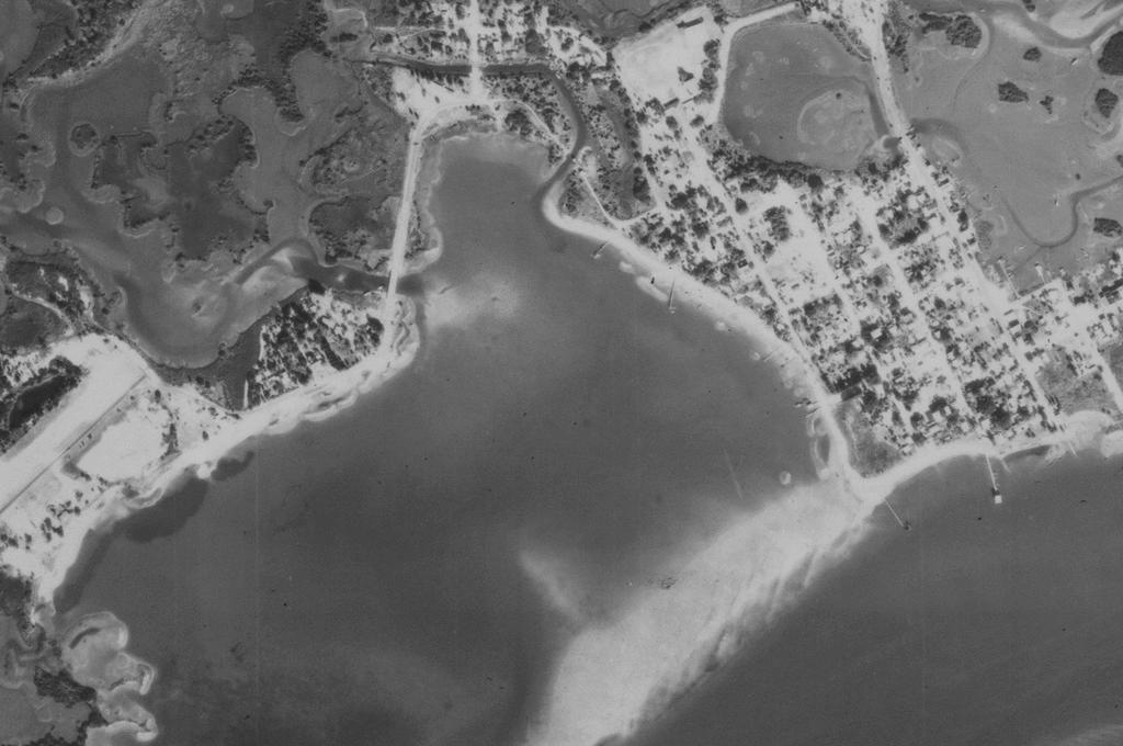
10 11/26/1961
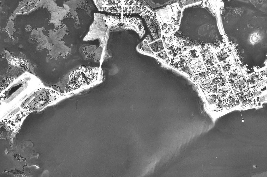
11 2/20/1974
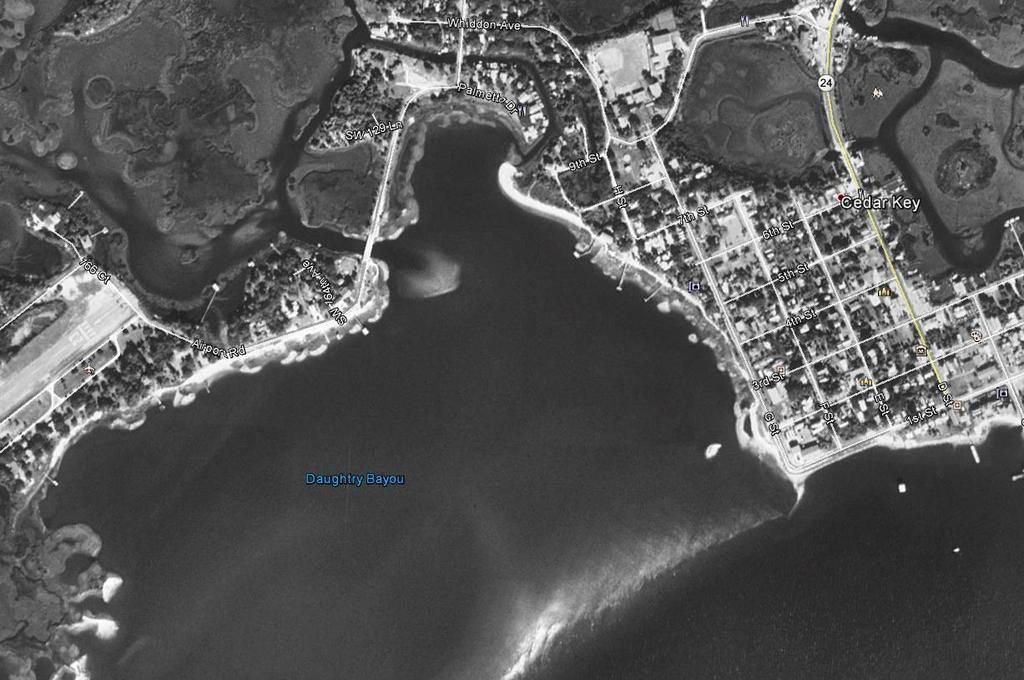
12 1/20/1994

13 1/20/1994 Airport Road 2/28/2006 1/20/1994 Airport Road


14 1/18/2012 Airport Road 11/17/2016 Airport Road


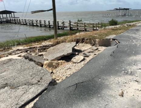
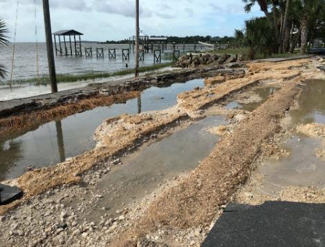
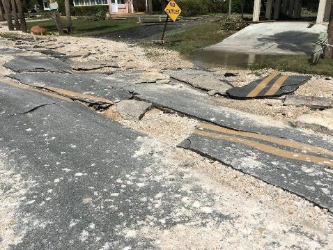
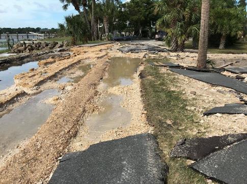
15 Airport Road damage from Hurricane Hermine correlated with gaps in oyster reef, unvegetated shoreline and width of shoreline.


16 Shoreline Erosion Wind and waves are constantly eroding shorelines As sea-level rises, wave dynamics and erosion change. Not all damage is associated with Hurricanes. Property loss associated with erosion is in the tens of billions of dollars annually. Habitat can also often be lost due to anthropogenic impacts such as boat wakes and deepening of water for navigation.


17 Factors Influencing Shoreline Erosion Wave energy and direction Longshore current/drift Natural wave breaks Sediment stability and trapping


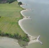
18 Approaches to mitigate shoreline erosion (high energy no change in use) Beach nourishment process of dumping or pumping sand from elsewhere onto an eroding shoreline Does not stop erosion, only provides more sand to erode buying time, but allows continued use of beach and a certain degree of protection. FDEP allotted beach nourishment projects FY = $37 million = $105 million St Augustine 2011 St Augustine 2012


19 Approaches to mitigate shoreline erosion (high energy some modification in use) Jetties, Groins and Breakwaters
 of US coastline has been armored with hardened structures.")

20 Approaches to mitigate shoreline erosion (low energy) Hardening using bulkheads, seawalls retaining walls. 14% (14,000 miles) of US coastline has been armored with hardened structures. NOAA estimates 1/3 of nation s estuarine shoreline will be hardened by 2100 if we continue at current rate. Generally effective at protecting property for a period of time. Provides little or no ecological benefit.
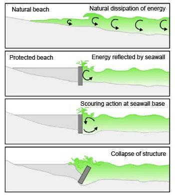
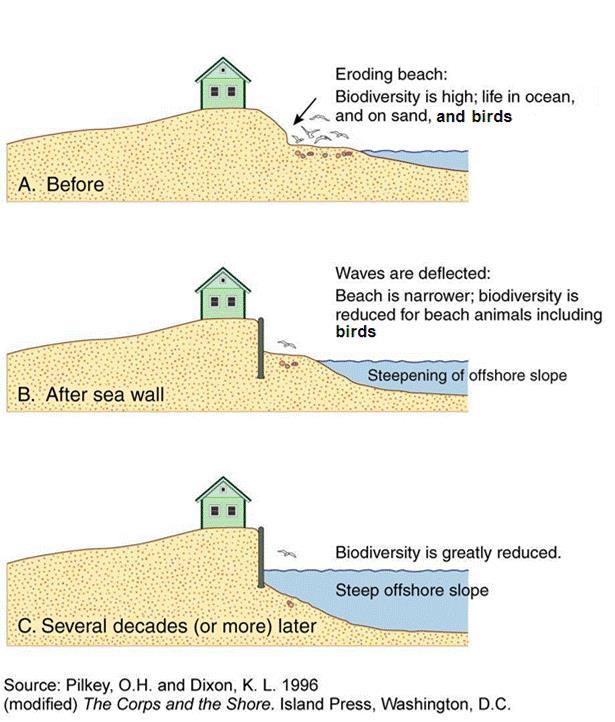
21 limitation with seawalls big and small

22 Loss of Habitat (area, zonation, access)


23 Is there an alternative? Probably Not Probably Intensity and frequency of waves in some areas is to great. Lower energy shorelines are more conducive to alternative shoreline stabilization techniques.


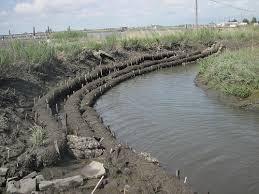
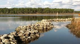
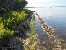
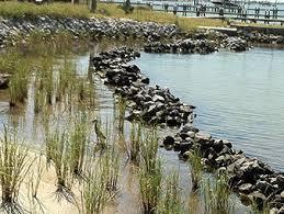
24 What is a Living Shoreline? A living shoreline is a method of land stabilization that protects the shoreline from erosion while also preserving, enhancing, or creating habitat. Living shorelines maintain the connectivity between land and water, and recreate the natural functions of a shoreline ecosystem. There are many different living shorelines techniques, yet they all generally employ natural or biodegradable materials such as stone, sand, oyster shells, or coconut fiber (coir) logs that are used in conjunction with the planting of native species.
25 Benefits of Living Shorelines Reduce wave energy and associated shoreline erosion (property loss) Buffer the effects of storms and boat wake Stabilize existing sediments Build up shoreline by trapping sediments and creating new sediment. Can actually accrete vs. erode. Improve water quality Provide habitat Provide a more contiguous ecotone between terrestrial and aquatic system. Assimilate carbon Beautify shorelines
26 Effective Living Shorelines are Designed to: Reduce and absorb incoming energy wave break reef vegetation Stabilize sediment vegetation Facilitate accretion Vegetation living structure oysters

27 Many creative approaches out there Site specifics and $$ will decide

28 Gradient from Gray to Green NOAA s Habitat Blueprint
29 Cedar Key Living Shoreline Visioning Session (March 3, 2017) Stakeholder Visioning session March 2018 Discussion of past and present uses along Airport Road and G-Street shorelines Presentation of shoreline mitigation options from Green to Gray. Golf cart tour around Cedar Key to view and discuss examples of Green to Gray shoreline stabilization. Discussion of pro s and con s of various stabilization techniques relative to various user groups. Individual preference selection of Green to Gray mitigation options.


30 Results of Preference selection for Green to Gray options
31 Count (preferred not-preferred) 20 Airport Road Individual Preferences Seawall or bulkhead Riprap Revetment Beach nourishment with Stabilization Beach nourishment Vegetation andbreakwater Vegetation and Edge/sill Vegetation planting
32 Mangrove Proliferation A major point of discussion and concern brought up during Visioning Session and G-street Design Workshop Florida common law recognizes that riparian landowner rights specifically include the right to an unobstructed view and the right of ingress to and egress from the water. However, wetland ecosystems including mangroves are also a protected environmental resource which provide a range of ecosystem services. The 1996 Mangrove Trimming and Preservation Act was created to balance landowner rights as well as services mangroves provide. Mangrove recruitment and establishment can be influenced by shoreline energy and climate conditions. Reducing shoreline energy (planting with vegetation or creating a breakwater) may/will likely increase the potential for mangrove recruitment. Preliminary consultation with FDEP indicates that they would be willing to include a more aggressive mangrove management plan (i.e. up to complete mechanical removal) as part of a Living Shoreline Permit if the expected increase in mangrove recruitment were going to be solely the result of the proposed Living Shoreline action.
33 Airport Road Design Workshop November 3, 2017 Presentation of four phased options based on preference of Beach nourishment with stabilization and vegetation with breakwater. No RipRap option was presented. Good discussion among various stakeholder groups present; however, property owners underrepresented.
34 Present Condition

 existing grade MHHW MLLW Airport Road concrete")
35 Present Conditions Shoreline cross sections A B C Airport Road concrete apron MHHW existing grade MLLW Airport Road concrete apron high marsh (S. patens) low marsh (S. alterniflora) existing grade MHHW MLLW Airport Road concrete apron MHHW existing grade MLLW
36 Phase 2: Vegetation + Breakwater
 low marsh (S. alterniflora) existing grade MHHW oyster reef/breakwater MLLW Airport Road concrete apron low marsh (S.")
37 Phase 2: Vegetation + Breakwater Shoreline cross sections A B C Airport Road concrete apron existing grade oyster reef/breakwater MHHW MLLW Airport Road concrete apron high marsh (S. patens) low marsh (S. alterniflora) existing grade MHHW oyster reef/breakwater MLLW Airport Road concrete apron low marsh (S. alterniflora) sand/shell fill existing grade oyster reef/breakwater MHHW MLLW


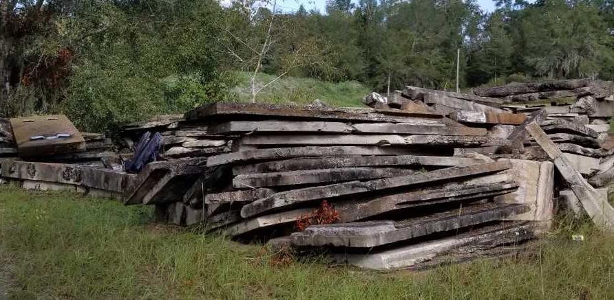
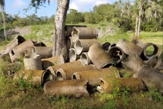
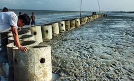
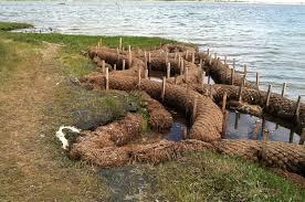
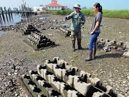
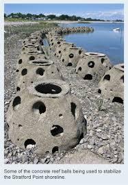
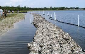
38 Materials Options for Phase 2: Oyster Castles Limerock Reef Balls Culvert, Concrete Slab (Bagged Shell)


39 Shape Options for Phase 2: ANGULAR STRAIGHT CURVED

40 Phase 4: Vegetation + Breakwater + Thin Fill + Dune Fill/Planting
 sand fill existing grade oyster reef/breakwater MHHW MLLW Airport Road dune species high marsh (S. patens) sand fill existing grade low marsh (S.")
41 Phase 4: Vegetation + Breakwater + Thin Fill + Dune Shoreline cross sections A B C Airport Road dune species high marsh (S. patens) sand fill existing grade oyster reef/breakwater MHHW MLLW Airport Road dune species high marsh (S. patens) sand fill existing grade low marsh (S. alterniflora) oyster reef/breakwater MHHW MLLW Airport Road dune species high marsh (S. patens) low marsh (S. alterniflora) sand fill sand/shell fill existing grade oyster reef/breakwater MHHW MLLW

42 RipRap Stabilization Option

43 RipRap Stabilization Option
44 Detailed Scorecard Summary Phase 2 Phase 4 RipRap Do Nothing 1)Environmental Service (C- = negative, B = no change, A+ = most a)carbon Sequestration A+ A+ C- b)wave dissipation A A++ A c)water quality A+ A+ C+ d)habitat/biodiversity A A++ C- category average A+* A++ C 2)Cost (C- = high, A+ = low) a)construction cost B C+ A- - b)maintenance cost B+ B+ A- - category average B B- A- - 3)Project longevity (C- = shortest time, A+ = longest time) 4)Likelihood of obtaining external funding (A+ = high, C- = low) A+ A+ A+ B- A- C -
Blakely Island, N Thatcher Bay. Restoration Recommendation: Rank Score (total score)
") Soft Shore Protection/Structure Removal Blueprint for San Juan County Forage Fish Beaches Appendix 2: Recommendations for sites scoring below the top ten, sorted by island (east to west) Blakely Island,
Soft Shore Protection/Structure Removal Blueprint for San Juan County Forage Fish Beaches Appendix 2: Recommendations for sites scoring below the top ten, sorted by island (east to west) Blakely Island,
The Foundation for The Gator Nation. August 16, Greetings,
 Institute of Food and Agricultural Sciences Savanna Barry, Ph.D. Regional Specialized Florida Sea Grant Agent 552 1 st Street, PO Box 878 Cedar Key, FL 32625 August 16, 2017 Greetings, I hope this letter
Building Coastal Resiliency at Plymouth Long Beach
 Building Coastal Resiliency at Plymouth Long Beach Department of Marine and Environmental Affairs March 30, 2017 Introducing Green Infrastructure for Coastal Resiliency Plymouth Long Beach & Warren s Cove
Living Shorelines Non-structural Erosion Control Practices Rhode Island Land & Water Summit, 2014
 Living Shorelines Non-structural Erosion Control Practices Rhode Island Land & Water Summit, 2014 D. Steven Brown (1) Kevin Ruddock (1) Rhonda Smith (2) The Nature Conservancy United States Fish and Wildlife
29 National Estuarine Research Reserves
 Estuarine habitat is where it's at! Living Shorelines for Erosion Control Whitney Jenkins North Carolina Coastal Reserve & National Estuarine Research Reserve Division of Coastal Management 29 National
Greg Berman (WHOI Sea Grant & Cape Cod Cooperative Extension) November 2, 2017
 November 2, 2017") November 2, 2017 Are You Ready for the Next Big Storm?: A Workshop for Hardy Cape Codders Greg Berman (WHOI Sea Grant & Cape Cod Cooperative Extension) Outline: ~30 min talk & time for questions Practical
November 2, 2017 Are You Ready for the Next Big Storm?: A Workshop for Hardy Cape Codders Greg Berman (WHOI Sea Grant & Cape Cod Cooperative Extension) Outline: ~30 min talk & time for questions Practical
Estuarine Shoreline Stabilization
 Estuarine Shoreline Stabilization Property Owner s Guide to Determining the Most Appropriate Stabilization Method Estuarine shorelines are dynamic features that experience continued erosion. Land is lost
The Sand Beaches of New Hampshire and Maine
 The Sand Beaches of New Hampshire and Maine Beach Preservation and Erosion Control Photographs provided by Joe Kelly and Steve Adams Cover photo: Reid State Park, ME Introduction The sand beaches of New
VIMS CCRM Coastal Management Decision Tools. Decision Tree for Undefended Shorelines and Those with Failed Structures
 VIMS CCRM Coastal Management Decision Tools Decision Tree for Undefended Shorelines and Those with Failed Structures Center for Coastal Resources Management Virginia Institute of Marine Science Gloucester
COASTAL MANAGEMENT AND PROTECTION METHODS! 1
 COASTAL MANAGEMENT AND PROTECTION METHODS! 1 Strategy What it does Cons Pros Examples SOFT ENGINEERING: The use of ecological principles and practices to reduce erosion and achieve the stabilization and
ALTERNATIVES FOR COASTAL STORM DAMAGE MITIGATION
 ALTERNATIVES FOR COASTAL STORM DAMAGE MITIGATION Dave Basco Old Dominion University, Norfolk, Virginia, USA National Park Service Photo STRUCTURAL (changes to natural, physical system) hardening (seawalls,
ALTERNATIVES FOR COASTAL STORM DAMAGE MITIGATION AND FUNCTIONAL DESIGN OF COASTAL STRUCTURES
 The University of the West Indies Organization of American States PROFESSIONAL DEVELOPMENT PROGRAMME: COASTAL INFRASTRUCTURE DESIGN, CONSTRUCTION AND MAINTENANCE A COURSE IN COASTAL DEFENSE SYSTEMS I CHAPTER
NORTHERN CELL OPTIONS SHORTLIST RECOMMENDATIONS
 OPTIONS SHORTLIST RECOMMENDATIONS Coastal Unit C: Bayview Options recommended for MCDA scoring. Status quo. Planting 3. Renourishment (gravel) 6. Beach-scraping 7. Restore shingle crest. Inundation accommodation
4/20/17. #32 - Coastal Erosion Case Histories - Lake Michigan
 Writing Assignment Due Monday by 11:59 pm #32 - Coastal Erosion Case Histories - Lake Michigan See main class web pages for detailed instructions Submit papers Illinois Compass No copying: Compass will
Montserrat. Wise practices for coping with. i b bea n Se a
 Wise practices for coping with Montserrat Car i b bea n Se a Fisheries Division, Montserrat Physical Planning Department, Montserrat University of Puerto Rico, Sea Grant College Program Caribbean Development
National Oceanic and Atmospheric Administration (NOAA)/ Mulberry Phosphate Trustee Council September 12, 2013
/ Mulberry Phosphate Trustee Council September 12, 2013") OYSTER REEF CREATION PROJECT DESIGN AND IMPLEMENTATION IN HILLSBOROUGH BAY, FLORIDA TAMPA BAY REGIONAL PLANNING COUNCIL AGENCY ON BAY MANAGEMENT MEETING National Oceanic and Atmospheric Administration
OYSTER REEF CREATION PROJECT DESIGN AND IMPLEMENTATION IN HILLSBOROUGH BAY, FLORIDA TAMPA BAY REGIONAL PLANNING COUNCIL AGENCY ON BAY MANAGEMENT MEETING National Oceanic and Atmospheric Administration
TITLE: North Carolina s Changing Shorelines. KEYWORDS: erosion - shorelines - mapping - sustainability
 UNC Coastal Studies Institute Teacher Resources 1 TITLE: North Carolina s Changing Shorelines KEYWORDS: erosion - shorelines - mapping - sustainability Changing shorelines impact coastal infrastructure.
GONE! Coastal Erosion Happens During Storms! Why Worry About Coastal Setbacks? Goals for Today
 RI Regulatory Setbacks & Buffers: Coastal Zone Management Issues New England Onsite Wastewater Training Program @ URI OWT 155 November 21, 2013 Goals for Today Understand the impacts of storms, coastal
RI Regulatory Setbacks & Buffers: Coastal Management Issues
 RI Regulatory Setbacks & Buffers: Coastal Management Issues New England Onsite Wastewater Training Program @ URI OWT 155 - November 29, 2012 James Boyd - Coastal Policy Analyst Photo: October 30, 2012
Coastal Hazards and Management in North Carolina. Braxton Davis April 14, 2015
 Coastal Hazards and Management in North Carolina Braxton Davis April 14, 2015 Coastal Facts and Figures 320 miles of ocean beaches 12,000+ miles of estuarine shoreline 2 million + acres of sounds, creeks,
Nevis. Wise practices for coping with
 Wise practices for coping with Nevis Caribbean Sea Nevis Historical and Conservation Society Department of Physical Planning, Natural Resources and Environment, Fisheries Division University of Puerto
Habitat Development: Habitat Boulders Lawson Pier Foreshore Enhancement
 Habitat Development: Habitat Boulders Improve the existing habitat by stabilising beach sediments. Increase biodiversity by creating new habitats and colonisation opportunities. Loose cobble is unstable;
STATUS REPORT FOR THE SUBMERGED REEF BALL TM ARTIFICIAL REEF SUBMERGED BREAKWATER BEACH STABILIZATION PROJECT FOR THE GRAND CAYMAN MARRIOTT HOTEL
 August 23 STATUS REPORT FOR THE SUBMERGED REEF BALL TM ARTIFICIAL REEF SUBMERGED BREAKWATER BEACH STABILIZATION PROJECT FOR THE GRAND CAYMAN MARRIOTT HOTEL performed by Lee E. Harris, Ph.D., P.E. Consulting
Energy Attenuation & Hybrid Living Shorelines: A Viable Tool for Coastal Resilience
 Energy & Hybrid Living Shorelines: A Viable Tool for Coastal Resilience Hot Topic Session Delaware Estuary Science & Environmental Summit Balancing Progress & Protection 10 Years of Science in Action January
Protecting our Beaches
 Protecting our Beaches South Amelia Island Shore Stabilization Project Nassau County, FL Mr. Drew Wallace President South Amelia Island Shore Stabilization Association (SAISSA) Mr. Bill Moore, AICP Project
SACO RIVER AND CAMP ELLIS BEACH SACO, MAINE SECTION 111 SHORE DAMAGE MITIGATION PROJECT APPENDIX F ECONOMIC ASSESSMENT
 SACO RIVER AND CAMP ELLIS BEACH SACO, MAINE SECTION 111 SHORE DAMAGE MITIGATION PROJECT APPENDIX F ECONOMIC ASSESSMENT Department of the Army New England District, Corps of Engineers 696 Virginia Road
REVETMENTS. Purposes and Operational Constraints. Purposes Erosion control o o. Revetment Design 4/5/2016. CE A676 Coastal Engineering
 REVETMENTS Ijsseldam, the Netherlands Orson P. Smith, PE, Ph.D. Instructor Purposes and Operational Constraints Purposes Erosion control o o Embankment Toe protection for a seawall, retaining wall or other
LAB: WHERE S THE BEACH
 Name: LAB: WHERE S THE BEACH Introduction When you build a sandcastle on the beach, you don't expect it to last forever. You spread out your towel to sunbathe, but you know you can't stay in the same spot
July 14, The Beaches Conference Greg Berman (WHOI Sea Grant & Cape Cod Cooperative Extension)
") July 14, 2017 The Beaches Conference 2017 Greg Berman (WHOI Sea Grant & Cape Cod Cooperative Extension) Annual downscaled global tropical cyclones, averaged over the six models. Uses data from IPCC Fifth
July 14, 2017 The Beaches Conference 2017 Greg Berman (WHOI Sea Grant & Cape Cod Cooperative Extension) Annual downscaled global tropical cyclones, averaged over the six models. Uses data from IPCC Fifth
Absecon Island Shore Protection The planning behind the project
 Absecon Island Shore Protection The planning behind the project Most residents of Atlantic City, Ventnor, Margate and Longport are now aware of upcoming plans to protect their common coastline with a beachfill
The Dynamic Coast. Right Place Resources. A presentation about the interaction between the dynamic coast and people
 The Dynamic Coast Houses threatened by coastal erosion in California Right Place Resources A presentation about the interaction between the dynamic coast and people For the rest of the presentations in
For more information or permission to reprint slides, please contact Donna Milligan at 1
 For more information or permission to reprint slides, please contact Donna Milligan at milligan@vims.edu 1 For more information or permission to reprint slides, please contact Donna Milligan at milligan@vims.edu
Today: Coastal Issues and Estuaries
 Today: Coastal Issues and Estuaries Coastal issues Human effect on coastlines What is an estuary Why are they so important? Circulation of water in estuary Environmental issues Coastal Issues: Problem
St Kitts. Wise practices for coping with
 Wise practices for coping with St Kitts Caribbean Sea Department of the Environment, St Kitts Fisheries Division, St Kitts Physical Planning and Development Division, St Kitts University of Puerto Rico,
Design and Construction of Living
 Design and Construction of Living Shorelines A course for living shorelines professionals September 29, 2010 This course made possible by a grant from the Virginia Coastal Zone Management Program NOAA
DUNE STABILIZATION AND BEACH EROSION
 DUNE STABILIZATION AND BEACH EROSION CAPE HATTERAS NATIONAL SEASHORE NORTH CAROLINA ROBERT DOLAN PAUL GODFREY U. S. DEPARTMENT OF INTERIOR NATIONAL PARK SERVICE OFFICE OF NATURAL SCIENCE WASHINGTON, D.
Shoreline Studies Program, Department of Physical Sciences, VIMS
 Living Shoreline Training Class 2017 1 Demonstration sites discussed in this talk. 2 A shoreline management plan for the entire creek made conceptual shoreline management recommendations along every stretch
Beach Restoration in Okaloosa and Walton Counties. FSBPA Technology Conference Clearwater, FL
 Beach Restoration in Okaloosa and Walton Counties FSBPA Technology Conference Clearwater, FL Presented by: Duncan Greer, E.I. February 5, 2015 PRESENTATION OUTLINE 1. Overview of Project Locations 2. Eglin
Feasibility Study for Restoration of Titlow Lagoon Fish Passage. South Puget Sound Salmon Enhancement Group
 Feasibility Study for Restoration of Titlow Lagoon Fish Passage South Puget Sound Salmon Enhancement Group January 2010 Feasibility Study for Restoration of Titlow Lagoon Fish Passage Prepared for South
Living Shorelines. Created by: JoAnn Moody & Tina Miller-Way Discovery Hall Programs Dauphin Island Sea Lab
 Living Shorelines Created by: JoAnn Moody & Tina Miller-Way Discovery Hall Programs Dauphin Island Sea Lab Living Shorelines Subject: Life Science Grade Level: 6 th -8 th Time Required: 60 min Key Terms:
DELAWARE S VULNERABLE COASTAL AREAS. DELAWARE INLAND BAYS and DELAWARE BAY RECONNAISSANCE STUDY
 DELAWARE S VULNERABLE COASTAL AREAS and the DELAWARE INLAND BAYS and DELAWARE BAY RECONNAISSANCE STUDY Kimberly K. McKenna, PG Delaware Dept. of Natural Resources & Environmental Control Division of Watershed
Design Considerations for Living Shorelines in Connecticut. Jennifer E.D. O Donnell Department of Marine Sciences University of Connecticut
 Design Considerations for Living Shorelines in Connecticut Jennifer E.D. O Donnell Department of Marine Sciences University of Connecticut October 2015 1 Contents Contents... 2 1 Why Living Shorelines?...
OECS Regional Engineering Workshop September 29 October 3, 2014
 B E A C H E S. M A R I N A S. D E S I G N. C O N S T R U C T I O N. OECS Regional Engineering Workshop September 29 October 3, 2014 Coastal Erosion and Sea Defense: Introduction to Coastal/Marine Structures
Atlantic Coast of Long Island, Jones Inlet to East Rockaway Inlet, Long Beach Island, NY Construction Update
 Atlantic Coast of Long Island, Jones Inlet to East Rockaway Inlet, Long Beach Island, NY Construction Update June 2016 US Army Corps of Engineers Project Purpose Three specific damage mechanisms of coastal
Anguilla. Wise practices for coping with. i b bea n Se a
 Wise practices for coping with Anguilla Car i b bea n Se a Department of Fisheries and Marine Resources, Anguilla Department of Physical Planning, Anguilla University of Puerto Rico, Sea Grant College
Conservation and Restoration Florida s Coastal Marshes: An Overview of MESS. Jeff Beal, Kent Smith, Erin McDevitt, Maria Merrill
 Conservation and Restoration Florida s Coastal Marshes: An Overview of MESS Jeff Beal, Kent Smith, Erin McDevitt, Maria Merrill FWC s MESS: -Marine/Estuarine Subsection -within Aquatic Habitat Conservation
Coastal management has lagged behind the growth in population leading to problems with pollution
 Fifty percent of the population of the industrialized world lives within 100 km of a coast. Coastal management has lagged behind the growth in population leading to problems with pollution and natural
NORTHAMPTON COUNTY WETLANDS BOARD Minutes May 15, 2013
 NORTHAMPTON COUNTY WETLANDS BOARD Minutes May 15, 2013 This was the regular meeting of the Northampton County Wetlands Board held on Wednesday, May 15, 2013 in the Board Chambers located at 16404 Courthouse
CHAPTER 4 - SHORELINE PROTECTION STUDY AND PLAN
 CHAPTER 4 Shoreline Protection Study and Plan 4-1 CHAPTER 4 - SHORELINE PROTECTION STUDY AND PLAN I. SHORELINE PROTECTION STUDY Lancaster County is a coastal community that has, as previously stated, approximately
SHOREHAM BEACH LOCAL NATURE RESERVE
 SHOREHAM BEACH LOCAL NATURE RESERVE Coastal Geography Education Programme 2014-15 S. Savage 2014 COASTAL GEOGRAPHY OPPORTUNITIES Shoreham Beach Shoreham Beach is a shingle spit formed over many centuries
Estuary Care Foundation SA: community led restoration & climate adaptation
 Estuary Care Foundation SA: community led restoration & climate adaptation Presentation to SA Coastal Conference 9 th November 2017 Catherine McMahon, Estuary Care Foundation Port River and Barker Inlet
COUNTY OF SAN MATEO Parks Department
 Agenda Item 5.B COUNTY OF SAN MATEO Parks Department DATE: March 16, 2015 COMMISSION MEETING DATE: April 9, 2015 TO: FROM: Parks and Recreation Commission Cecily Harris, Development Consultant SUBJECT:
ST. LUCIE COUNTY, FLORIDA
 ST. LUCIE COUNTY, FLORIDA COASTAL STORM RISK MANAGEMENT STUDY Draft Feasibility Study & Integrated Environmental Assessment Public Meeting Presented by U.S. Army Corps of Engineers Jacksonville District
Tracy E. Skrabal. October 2, 2012
 Tracy E. Skrabal October 2, 2012 Jurisdiction Living Shorelines/Sills Timeline for Permit Bulkhead/Revetments North Atlantic Division New England Division suspended all nationwide permits March 20, 2012
Dominica. Wise practices for coping with. i b bea n Se a
 Wise practices for coping with Dominica Car i b bea n Se a Forestry,Wildlife and Parks Division, Dominica University of Puerto Rico, Sea Grant College Program Caribbean Development Bank UNESCO Environment
Long Term Success and Future Approach of the Captiva and Sanibel Islands Beach Renourishment Program
 2017 National Conference on Beach Preservation Technology February 8-10, 2017; Stuart, Florida Long Term Success and Future Approach of the Captiva and Sanibel Islands Beach Renourishment Program Thomas
Earth Science Chapter 16 Section 3 Review
 Name: Class: Date: Earth Science Chapter 16 Section 3 Review Multiple Choice Identify the choice that best completes the statement or answers the question. 1. The movement of water that parallels the shore
FINAL ENVIRONMENTAL IMPACT STATEMENT ON BROWARD COUNTY SHORE PROTECTION PROJECT SEGMENTS II AND III BROWARD COUNTY, FLORIDA
 FINAL ENVIRONMENTAL IMPACT STATEMENT ON BROWARD COUNTY SHORE PROTECTION PROJECT SEGMENTS II AND III BROWARD COUNTY, FLORIDA 1. PROJECT PURPOSE AND NEED 1.1. PROJECT AUTHORITY. 1.1.1. INITIAL AUTHORIZATION.
ST. JOSEPH PENINSULA, GULF COUNTY, FLORIDA Beach Re-Nourishment and Environmental Enhancement Project RECOMMENDATIONS
 ST. JOSEPH PENINSULA, GULF COUNTY, FLORIDA Beach Re-Nourishment and Environmental Enhancement Project RECOMMENDATIONS January 23, 2018 543 Harbor Boulevard, Suite 204 Destin, Florida 32541 850.654.1555
Combating Erosion at Mosquito Point
 2010 Combating Erosion at Mosquito Point A Report Generated by the Students of EVST 305: Environmental Problem Solving Randolph-Macon College 3/11/2010 TECHNICAL REPORT RMC-EVST 2009-2 Introduction to
US Beach Nourishment Experience:
 Beach Nourishment: Introduction of new sand to the beach by truck or dredge Large beach >1 million cubic yards (100,000 dump truck loads) Funding is a combination of federal, state, local & private Also
Regular Workshop October 20, 2014 Agenda Item: Dr. Albert E. Browder, PE; Olsen Associates, Inc.
 Regular Workshop October 20, 2014 Agenda Item 8 Agenda Item: Presenter: Summary: Beach Update Town Manager; Dr. Albert E. Browder, PE; Olsen Associates, Inc. At the January 21, 2014 Regular Workshop Meeting,
Nearshore Sediment Transport What influences the loss of sediment on Beaches? - Waves - Winds - Tidal Currents - River discharge - Runoff
 Tides & Beaches Nearshore Sediment Transport What influences the loss of sediment on Beaches? - Waves - Winds - Tidal Currents - River discharge - Runoff Oceans Ocean Topography Physical Structure of the
County of Santa Barbara Permit Option Analysis Goleta Beach JULY 13, 2017
 County of Santa Barbara Permit Option Analysis Goleta Beach JULY 13, 2017 Introduction 2 Goleta Beach Park welcomes 1.5 million visitors annually Amenities include: Picnic Areas and Group Areas w/bbqs
THE ROLE OF NATURE: UNDERSTANDING HOW NATURAL FEATURES CONTRIBUTE TO COASTAL RISK REDUCTION. Denise Reed, Chief Scientist
 THE ROLE OF NATURE: UNDERSTANDING HOW NATURAL FEATURES CONTRIBUTE TO COASTAL RISK REDUCTION Denise Reed, Chief Scientist The Water Institute of the Gulf is a not-for-profit, independent research institute
Mouth of the Columbia River Jetties Three-Phase Construction Plan
 Mouth of the Columbia River Jetties Three-Phase Construction Plan Project Overview October 9, 2012 US Army Corps of Engineers MCR Jetties Major Rehabilitation Sand Island pile dikes 1930-1935 Columbia
Coastal Change and Conflict
 Coastal Change and Conflict Outline of the Topic Contrasting Coasts why do all coasts not look the same? Geology of the coast the impact rock structure has on the coastline Waves Constructive and destructive
Figure79. Location map for the 10 NJBPN profile sites in Atlantic County, NJ 155
 154 Figure79. Location map for the 10 NJBPN profile sites in Atlantic County, NJ 155 ATLANTIC COUNTY SPRING 2009 to FALL 2010 The Atlantic County coastline consists of three barrier islands. Between Little
Figure 1. Schematic illustration of the major environments on Mustang Island.
 STOP #1: PACKERY CHANNEL BEACH TO BAY We will start this field guide near the north jetty of Packery Channel and hike across the island to Corpus Christi Bay (fig. 1). The island emerges from the Gulf
VENICE LOCAL COASTAL PROGRAM UPDATE: COASTAL HAZARDS WELCOME
 VENICE LOCAL COASTAL PROGRAM UPDATE: COASTAL HAZARDS WELCOME 1 Introducing the Team Hosted by the Department of City Planning and grant funded in part by the California Coastal Commission 2 Workshop Purpose
4/20/17. #31 - Coastal Erosion. Coastal Erosion - Overview
 Writing Assignment Due Monday by 11:59 pm #31 - Coastal Erosion Beach front property! Great View! Buy now at a great price! See main class web pages for detailed instructions Essays will be submitted in
The Falmouth Conservation Commission MEETING MINUTES - WEDNESDAY, DECEMBER 12, 2018 Selectmen s Meeting Room, Falmouth Town Hall, 7:00 p.m.
 The Falmouth Conservation Commission MEETING MINUTES - WEDNESDAY, DECEMBER 12, 2018 Selectmen s Meeting Room, Falmouth Town Hall, 7:00 p.m. Present: Absent: Jamie Mathews, Vice-Chair Betsy Gladfelter Maurie
Texas passes, longshore transport, hurricanes, beach erosion and sea level
 Texas passes, longshore transport, hurricanes, beach erosion and sea level Richard L. Watson, Ph.D. (361) 749-4152 Field work can be strange! 120,000 years of sea level Years each zone exposed above S/L
PUBLIC EXHIBITION OF COASTAL ZONE MANAGEMENT PLAN FOR COLLAROY-NARRABEEN BEACH AND FISHERMANS BEACH
 ITEM 8.3 REPORTING MANAGER TRIM FILE REF 2014/110936 ATTACHMENTS PUBLIC EXHIBITION OF COASTAL ZONE MANAGEMENT PLAN FOR COLLAROY-NARRABEEN BEACH AND FISHERMANS BEACH GROUP MANAGER NATURAL ENVIRONMENT 1
Coastal issues: Beaches and Estuaries. Recent Sea Level: Beaches: Baltimore D.C. Patomac R. Chesapeake Bay
 Coastal issues: Beaches and Estuaries Definitions: Coast = broad zone where both marine & terrestrial processes act It includes the beach, lagoons, marshes, bars etc. Coastal processes act to shape the
Chronic coastal erosion is a statewide problem
 Chronic coastal erosion is a statewide problem 1 Seawalls are constructed where there is erosion, but they do not solve the erosion they often worsen it along adjacent shores. Hawaii needs erosion solutions.
PRACTICE STANDARDS AND NR 328. Choosing a Technique and Getting a Permit
 PRACTICE STANDARDS AND NR 328 Choosing a Technique and Getting a Permit CHOOSING A TECHNIQUE Define cause of erosion Upland runoff? Impervious areas? Velocities? Wave energies? Boat or wind generated?
Q1. What are the primary causes/contributors to coastal erosion at Westshore and the concept of longshore / littoral drift.
 Q1. What are the primary causes/contributors to coastal erosion at Westshore and the concept of longshore / littoral drift. In order of (timing related) contribution to present problem 1. Beach is too
Shoreline Erosion Control Failures and How To Avoid Them
 2008 Illinois Lake Management Association Shoreline Erosion Control Failures and How To Avoid Them by: Hank Sutton, President, Lake Rip Rap, Inc. www.lakeriprap.com - www.macoupinboats.com Setting the
City of Burnaby Environmental Review Committee (ERC) Guide for Applicants
 Guide for Applicants") City of Burnaby Environmental Review Committee (ERC) Guide for Applicants 2017-2018 This Guide summarizes the ERC process for project review including applications for a relaxation (variance) to the development
City of Burnaby Environmental Review Committee (ERC) Guide for Applicants 2017-2018 This Guide summarizes the ERC process for project review including applications for a relaxation (variance) to the development
ADAPTATION TO SEA LEVEL RISE AND COASTAL IMPACTS
 ADAPTATION TO SEA LEVEL RISE AND COASTAL IMPACTS Miramar Inn, Half Moon Bay, March 1, 2014 Photo by Jack Sutton, all rights reserved 2/22/17 AdaptLA Workshop California Coastal Commission 2 Plans and regulates
RE: Hurricane Matthew Beach Damage Assessment and Recommendations [CSE 2416]
![RE: Hurricane Matthew Beach Damage Assessment and Recommendations [CSE 2416]](/thumbs/83/87675702.jpg "RE: Hurricane Matthew Beach Damage Assessment and Recommendations [CSE 2416]") October 25, 2016 Iris Hill Town Administrator Town of Edisto Beach 2414 Murray St Edisto Beach SC 29438 RE: Hurricane Matthew Beach Damage Assessment and Recommendations [CSE 2416] Dear Iris, Hurricane
October 25, 2016 Iris Hill Town Administrator Town of Edisto Beach 2414 Murray St Edisto Beach SC 29438 RE: Hurricane Matthew Beach Damage Assessment and Recommendations [CSE 2416] Dear Iris, Hurricane
Deep-water orbital waves
 What happens when waves approach shore? Deep-water orbital waves Fig. 9.16, p. 211 Wave motion is influenced by water depth and shape of the shoreline wave buildup zone surf zone beach Wave base deepwater
Impact of Hurricane Matthew on the Atlantic Coast of Florida
 Impact of Hurricane Matthew on the Atlantic Coast of Florida A coastal engineer was driving across country and his jeep broke down in front of a monastery. It was late in the day and the monks invited
CHAPTER 4 DESIRED OUTCOMES: VISION, GOALS, AND OBJECTIVES
 CHAPTER 4 DESIRED OUTCOMES: VISION, GOALS, AND OBJECTIVES Vision One of the first steps in developing this Plan was articulating a vision - a clear statement of what the Plan strives to achieve and what
Soft Designs for a Harsh Climate: Trends in Coastal Engineering
 Alaska Department of Transportation & Public Facilities Ruth Carter, PE, and Harvey Smith, PE Coastal Engineering Section 20 October 2014 Soft Designs for a Harsh Climate: Trends in Coastal Engineering
TO: FROM: Y.102/MIN
 TO: FROM: Hastings-on-Hudson Shoreline Committee Amanda Ludlow and Kathryn Sommo, Roux Associates, Inc. DATE: March 13, 2017 RE: Meeting with NYSDEC Region 3 Hastings-on-Hudson Conceptual Shoreline Plans
Modeling Beach Erosion
 Ocean Lecture & Educator s Night May 16, 2012 Modeling Beach Erosion Below is an overview of the activity Modeling Beach Erosion (New Jersey Sea Grant Consortium, Education Program) to incorporate information
Beach Nourishment Impact on Beach Safety and Surfing in the North Reach of Brevard County, Florida
 Beach Nourishment Impact on Beach Safety and Surfing in the North Reach of Brevard County, Florida Prepared by John Hearin, Ph.D. Coastal Engineering Vice Chairman Cocoa Beach Chapter Port Canaveral Patrick
Environmental Protection on the Gold Coast of Queensland, Australia. 1. What is the appeal of the Gold Coast to tourists?
 Environmental Protection on the Gold Coast of Queensland, Australia Sections 1. What is the appeal of the Gold Coast to tourists? 2. How are Gold Coast visitor trends changing? 3. How can the impacts of
Part 9 Specific Land Uses - Foreshore & Waterway Development
 7 FORESHORE AND WATERWAY DEVELOPMENT This section applies to the following development uses proposed within the foreshore area (defined by LM LEP 2014), and contains Council s specific requirements for
The District Municipality of Muskoka 70 Pine Street Bracebridge ON P1L 1N3
 Public Information Centre Summary Report Muskoka Road 15 (Santa s Village Road) Transportation Improvements from the Beaver Creek Bridge to the Entrance of Santa s Village The District Municipality of
New Jersey Coastal Zone Overview. The New Jersey Beach Profile Network (NJBPN) 3 Dimensional Assessments. Quantifying Shoreline Migration
 3 Dimensional Assessments. Quantifying Shoreline Migration") New Jersey Coastal Zone Overview The New Jersey Beach Profile Network (NJBPN) Objectives Profile Locations Data Collection Analyzing NJBPN Data Examples 3 Dimensional Assessments Methodology Examples Quantifying
New Jersey Coastal Zone Overview The New Jersey Beach Profile Network (NJBPN) Objectives Profile Locations Data Collection Analyzing NJBPN Data Examples 3 Dimensional Assessments Methodology Examples Quantifying
MOREHEAD CITY HARBOR, NC. Dredged Material Management Plan (DMMP)
") MOREHEAD CITY HARBOR, NC Dredged Material Management Plan (DMMP) Public Meeting/Info Session 15 January 2014 US Army Corps of Engineers Morehead City Harbor DMMP Presentation Topics Morehead City Harbor
MOREHEAD CITY HARBOR, NC Dredged Material Management Plan (DMMP) Public Meeting/Info Session 15 January 2014 US Army Corps of Engineers Morehead City Harbor DMMP Presentation Topics Morehead City Harbor
Deadman s Island Appreciation for past, present and future. Project Manager- Heather Reed Ecological Consulting Services Inc.
 Deadman s Island Appreciation for past, present and future Project Manager- Heather Reed Ecological Consulting Services Inc. Deadman s Island Rare Gem 1743 1698 1742 18 th Century Used by the Spanish and
SPECIAL SPRING 2018 STORM REPORT ON THE CONDITION OF THE MUNICIPAL BEACHES FOR THE BOROUGH OF STONE HARBOR, CAPE MAY COUNTY, NEW JERSEY
 SPECIAL SPRING 2018 STORM REPORT ON THE CONDITION OF THE MUNICIPAL BEACHES FOR THE BOROUGH OF STONE HARBOR, CAPE MAY COUNTY, NEW JERSEY Aerial photograph taken April 21, 2018 showing the view up the beach
Natural Shoreline Restoration for High Energy Shorelines. Brian Majka Restoration Ecologist 3/7/2019
 Natural Shoreline Restoration for High Energy Shorelines Brian Majka Restoration Ecologist 3/7/2019 Today we ll discuss: High energy shorelines Restoration techniques for high energy shorelines Project
Fact Sheet Ordinance Regulating Erosion Threatened Structures
 Fact Sheet Ordinance Regulating Erosion Threatened Structures Town of Duck, North Carolina August 15, 2011 What is being considered? The Town of Duck Council is considering an ordinance to limit the encroachment
St Vincent. Grenadines. Wise practices for coping with. and the. i b bea n Se a
 Wise practices for coping with St Vincent Car i b bea n Se a and the Grenadines Bequia Community High School, Bequia, St Vincent and the Grenadines Ministry of Agriculture, Lands and Fisheries, St Vincent
Chesil Beach, Dorset UK High energy, shingle coastline. Brighton Beach, Sussex UK Pebble beach
 Beaches: Depositional landform Extends from the highest high tide to the lowest low tide. Very important temporary store in coastal system. Accretion: sediment returning to the visible portion of a beach