The Detroit Road Traffic, Parking Analysis and Marion Ramp Feasibility Study
|
|
|
- Juliet Taylor
- 5 years ago
- Views:
Transcription


1 Submitted to: The City of Rocky River September 21, 2015 The Detroit Road Traffic, Parking Analysis and Marion Ramp Feasibility Study
2 Table of Contents Chapter 1: Executive Summary Chapter 2: Purpose of the Study Chapter 3: Background Information 3.1 History 3.2 Existing Conditions 3.3 Identification of the Study Area Chapter 4: Description of the Corridor Chapter 5: Traffic Study 5.1 Peak Hour Traffic and Pedestrian Count Data 5.2 Development of Future Traffic Volume Data 5.3 Existing and Future No-Build Levels of Service (LOS) 5.4 Identification of Traffic Deficiencies 5.5 Proposed Traffic Improvements 5.6 Build vs No Build LOS 5.7 Linda Street Corridor Concerns 5.8 Recommendations Chapter 6: Pedestrian and Bicycle Concerns 6.1 Summary of Existing Conditions 6.2 Bumpouts/Mid-Block Crossings 6.3 Rectangular Rapid Flash Beacons (RRFB s) 6.4 Bicycle Connectivity 6.5 Sharrows 6.6 Reduce the Width of Clifton Boulevard/Lake Road 6.7 Recommendations Chapter 7: Parking Study 7.1 Summary of Existing Parking by Location 7.2 Parking Usage and Challenges 7.3 Recommendations Chapter 8: Marion Ramp Study 8.1 Ramp Utilization 8.2 Summary of Condition 8.3 Route Signage 8.4 Land Use Requirements for Land Vacated if Ramps are Removed 8.5 Recommendations Chapter 9: Community Engagement 9.1 Stakeholders Workshops 9.2 Public Meeting Chapter 10: Funding Summary 10.1 Identification of Funding Sources per Project Element Chapter 11: Cost Estimate and Summary of Short, Medium, and Long Term Recommendations
3 The Detroit Road Traffic, Parking Analysis and Marion Ramp Study Appendix Appendix A: Exhibits Exhibit 1-1 Traffic Study Area Exhibit 1-2 Recommended Road Changes Exhibit 1-3 Recommended Pedestrian Bumpouts & Crosswalks Exhibit 1-4 Recommended Bike Network Exhibit 1-5 Existing Parking Inventory East of Marion Ramps Exhibit 1-6 Existing Parking Inventory West of Marion Ramps Exhibit 1-7 Recommended Additional Parking & Wayfinding Exhibit 1-8 Potential Land Use Exhibit 1-9 Recommended Bike & Roadway Improvements Appendix B: Bridge Condition Report
4 Chapter 1: Executive Summary The City of Rocky River was awarded a Transportation for Livable Communities Initiative (TLCI) grant through the Northeast Ohio Areawide Coordinating Agency (NOACA) to study traffic, parking, and pedestrian and bicycle movements in the vicinity of the Detroit Road corridor. The project study area is within western Lakewood and eastern Rocky River in Cuyahoga County, Ohio. The limits extend along Lake Road from West Clifton Boulevard to Wagar Road and along Detroit Road between Wooster Road and Wagar Road for assessing traffic while the main study area for improvements to pedestrian, bicycle, and parking issues is focused along Detroit Road, between Lakeview Avenue and Old Detroit Road. There are traffic congestion and deficiencies in parking, pedestrian, and bicycle facilities within the residential and commercial district surrounding Detroit Road. The purpose of this study was to assess existing conditions and determine improvements that can be made to better facilitate vehicular, pedestrian, and bicycle movements/connections within the study area as well as identify opportunities for improved parking facilities. Additionally, the study assessed the feasibility of removing or repurposing the Marion Ramps from the study area and the resulting impacts of this change in traffic pattern within the study area, specifically along West Clifton Boulevard, Sloane Avenue, Linda Street, and nearby residential streets. Traffic counts and associated analysis of traffic volumes and signal operations were assessed to determine existing and future Level of Service (LOS) to use as the basis of the recommendations. The Detroit Road Traffic, Parking Analysis, and Marion Ramp Feasibility Study was created during a multi-level community engagement program that consisted of civic leaders, a focus group of stakeholders, and the general public. The overall direction of the study was driven by the Rocky River community stakeholders. Their value came into play in guiding the development, providing input, assessing issues, and formulating decisions as the project progressed. In a series of workshops, the stakeholders provided feedback and suggestions while the AECOM team supplied the technical input, analysis, and best practices for the concept and recommendation process. Recommendations for improvements are categorized as short, medium, and long term improvements to address the varying needs of the community. The study identifies various improvements and their ability to address the goals of improving pedestrian and bike linkages. It also provides an increase of opportunities for parking and creating a more walkable experience, while offering acceptable levels of traffic operations. The timeframe for the implementation of these alternatives is variable and dependent upon specific need and available funding. A summary of the recommendations and their associated implementation schedule are as follows: Short-term Improvements: (0 2) years 1. Resurface Detroit Road * 2. Upgrade various project signals to include protected left-turn movements 3. Revise signal timings for better vehicular and pedestrian operations 4. Add Sharrows and associated signage to Detroit Road 5. Improve parking by preparing a parking wayfinding plan to educate patrons 6. Place bicycle racks proximate to Detroit Road 7. Improve/sign bicycle connections at Eldora Road and Dorothy Avenue Mid-term Improvements: (3 5) years 1. Provide pedestrian bump outs along Detroit Road and decorative crosswalks 2. Improve curb ramps at intersections 3. Provide mid-block pedestrian crossings with Rectangular Rapid Flash Beacons (RRFB s) 4. Reduce Clifton Avenue to one lane in each direction over bridge to provide bike lanes Long-term Improvements: (5+) years 1. Remove the Marion Ramps, grade and provide basic landscape the areas adjacent to Lake Road 2. Re-route SR2 from Marion Ramp to coincide with US20 along West Clifton Boulevard and Sloane Avenue
5 3. Construct new Arundel Road intersection and connector road to Beach Cliff Blvd including trail 4. Provide additional parking along Detroit and behind Beachcliff Market Square in area vacated by Marion Ramps 5. Connect Beachcliff area to the Linda Street Corridor 6. Construct a streetscape project that upgrades the existing signals along Detroit Road to new decorative mast arms with all new signal and pedestrian heads. Also, provide additional roadside amenities such as street trees, benches and trash receptacles. 7. Construct a pedestrian bridge spanning the Norfolk Southern (NS) railroad tracks * Pavement resurfacing is part of the ODOT Urban Paving Program. Other roadway improvements can be undertaken with this mill/resurface project. Other items to be incorporated in the project are listed in the recommendations table above and costs associated with these items as well as other improvements, which can be implemented at the City s discretion are provided in Appendix C. The costs are provided in a menu type format as they can be executed separately or in combination with other improvements.
6 Chapter 2: Purpose of the Study The City of Rocky River has recently been awarded a TLCI grant from NOACA. The program facilitates local governments with the execution of transportation related studies which endeavor to improve infrastructure for the benefit of their community. The TLCI grant presented to Rocky River is aimed at analyzing traffic and parking on Detroit Road and at studying the feasibility of removing the Marion Ramp connection between Lake Road / Clifton Road and Detroit Road. This project represents a once in a generation opportunity for the City to evaluate the possibility of reconfiguring traffic access to downtown Rocky River, opportunities for pedestrian and bike neighborhood linkages, making downtown more walkable, and creating redevelopment opportunities. With new commercial developments along Detroit Road upcoming, this study represents an important step to examine traffic congestion and parking concerns necessary to support further redevelopment of downtown Rocky River and to define a roadway improvement program for the future. This traffic study will evaluate the feasibility of removing or repurposing the existing Marion Ramps through data collection, a no-build condition analysis, and a build condition analysis. This study will outline the impacts and costs associated with the repurposing the existing ramps and providing alternate routing extending beyond the immediate downtown area. The traffic study also includes a comprehensive parking analysis for the downtown area. A majority of parking in the downtown Rocky River district is provided via surface lots with some additional on-street parking. The parking primarily serves a commercial district with smaller amounts of residential and office space. This study will present the results from a lengthy public involvement process involving numerous project stakeholder working sessions that helped identify options to efficiently use existing parking, increase parking supply, and reduce the parking demand. The pedestrian and bicycle studies focus not only on improved connections for pedestrians and bicyclists along Detroit Road and across the study area, but also improvements that can be made to existing facilities and provisions for new facilities and amenities which will provide a safe and more enjoyable experience. The goal of the overall study was to determine methods for unifying and connecting the residential and commercial aspects and providing a corridor that is efficient for all modes of transportation and productive for the local businesses.
7 Chapter 3: Background Information 3.1 History As a result of the Community Development Block Grants (CDBG) funding received for Old Detroit Road and Linda Street, there has been development growth in the area which has resulted in increased vehicular, bicycle, and pedestrian traffic. The bicycle traffic is not accommodated properly on the existing narrow sidewalks and roadways which do not include accommodations for bicycles. Additionally, there is limited parking availability in the core retail/restaurant/business area. Development continues within this central business district as several new restaurants have opened recently and a Whole Foods grocery store will be opening soon in River Square Shopping Center. Existing resources including the Rocky River High and Middle Schools, Rocky River Public Library and St. Christopher Church and School likewise adversely affect traffic operations. The Marion Ramps were constructed in the early 1960 s as a means of connecting the downtown with the western suburbs via the West Shoreway and Clifton Boulevard. While still providing this transportation connection, Interstate 90, which provides a high speed connection between downtown and points east, has become the major commuter route for traffic. Clifton Blvd and the West Shoreway, accessed from Detroit Road via Interstate-like ramp structures, offer low speed options, and are utilized by commuters from western Rocky River, Bay Village, and Lorain County via Lake Road and via the Marion Ramps by commuters in eastern Rocky River. Maintained by the Ohio Department of Transportation (ODOT), these structures are considered obsolete infrastructure when compared with other available transportation alternatives. The removal or repurposing of these ramps, if possible from a traffic and community acceptance perspective, may provide land area to help solve other challenges the community is working to address. 3.2 Existing Conditions The primary roadways that would be affected by traffic redistribution for this project are West Clifton Boulevard, Sloane Avenue, Linda Street, Wagar Road, and Detroit Road. The pavement condition of each of these roadways was assessed during a windshield survey of the project area. West Clifton Boulevard (signed as US 20 and SR 237) is a four-lane (five at intersections to provide for turn capacity) asphalt roadway that is in good condition. Sloane Avenue (signed US 20) is a four-lane concrete roadway and is in good condition. Along the portions of the roadway, the curb lanes are utilized for on-street parking. Linda Street is a two-lane asphalt roadway which is in very good condition as a result of a recent improvement project. Wagar Road is a two-lane asphalt roadway with concrete curb and gutters. Its condition is good as concrete patches have been placed in deteriorated areas. Detroit Road (State Route 254) is a three-lane (one-lane in each direction with a two-way left turn lane) roadway which widens in some areas for on-street parking. The asphalt roadway is in poor condition and is scheduled to be resurfaced in 2017 as part of ODOT s Resurfacing Program for State Routes within municipalities. The ramp pavement on the Marion Ramps is asphalt and is in fair condition. Sidewalks are located along all of these roadways with the exception of the Marion Ramps. While some are adjacent to the roadway or buffered by pavers (along Linda Street and Detroit Road), most are buffered from the street by a grass tree lawn. Crosswalks are located at signalized intersections and across minor side streets at nonsignalized intersections and vary from basic pavement markings to decorative stamped and colored concrete. Signalized intersections are located at intersections between Detroit Road, Wagar Road, Lakeview Avenue, Smith Court, Linda Street, the River Square Shopping Center, Marion Ramps, Rockland Avenue, Wright Avenue, Wooster Road, Lake Road, and Sloane Avenue, at the intersections between West Clifton Boulevard and Clifton and Sloane Avenue and at the intersection of Lake Road with Linda Street, Kensington Road, Avalon Drive, Morewood Parkway and Wagar Road. Inventories of all intersections signalized or not, along Detroit Road were observed for the presence of ADA compliant pedestrian facilities. Half of these facilities are in need of an upgrade to the current standards. Bicycle facilities are less apparent. Bikes are able to share the road or utilize the sidewalks. There are points of access from the neighborhood south of River Square Shopping Center. Facilities marked or signed to safely convey
8 bicyclists to this area, to the Cleveland Metroparks, or to designated facilities along Detroit Road in Lakewood are lacking. Parking is located in private lots and garages associated with individual businesses or retail areas. On-street parking is offered in the commercial area along Detroit Road. The demand for parking varies based upon the time of day as development ranges from daytime to evening/weekend users. Quantity of parking appears adequate for most of the day, but the general observation by businesses is that there is an overall lack in available parking in the area. On the other hand, there are some underutilized parking lots which are less convenient or unknown to those less familiar with the areas that are not used due to their location. 3.3 Identification of the Study Area The project study area is within western Lakewood and eastern Rocky River in Cuyahoga County Ohio. The limits extend along Lake Road from West Clifton Blvd to Wagar Road and along Detroit Road between Wooster Road and Wagar Road for assessing traffic. The key area of our study is along Detroit Road; it is located in the center of downtown Rocky River and is where a majority of the existing and future commercial development is located. Nine intersections along Detroit were analyzed starting at Detroit and Wagar Rd and stopping at Detroit and Sloane Ave. Three intersections along W. Clinton were analyzed which is located east of Detroit Road and two intersections on Lake Road were analyzed which are located north of Detroit Road. This area and connections to the commercial district of Detroit Road were the focus of improvements to pedestrian, with bicycle and parking issues is focused along Detroit Road between Lakeview Avenue and Old Detroit Road, where the majority of development and associated congestion is located. A map of the project study area is provided in Appendix A, Exhibit 1-1.
9 Chapter 4: Description of the Corridor This study focuses primarily on the section of Detroit Road beginning at Wagar Road in Rocky River and traversing northeast past the Beachcliff Market Square shopping center to Sloane Avenue in Lakeview. This section of Detroit Road is designated as a State Route (SR 2 and SR 254). At the Marion Court intersection, SR 2 is redirected to Clifton Boulevard by way of the Marion Ramps just west of the downtown area. Detroit Road is basically a threelane, thirty-two (32) foot wide roadway with one through lane in each direction and a center turn lane that transitions to dedicated left turn lanes at most of the major intersections. The speed limit on Detroit Road varies from 35 mph to the west to 25 mph to the east. The corridor includes sidewalks, but no bicycle facilities such as bike lanes, sharrows, or shared use paths. There are thirteen (13) existing traffic signals within the study area, all of which include some kind of pedestrian accommodations such as crosswalks, pedestrian pushbuttons, and pedestrian signal heads. During peak school times, crossing guards are provided at many of the crossings. The Detroit Road corridor includes a myriad of business, schools, churches, and residences. Some of which include: the Rocky River High School, St. Christopher s Church, Rocky River United Methodist Church, the Beachcliff Market Square, and Heinen s Shopping Center. The existing Marion Bridge and its associated ramps makes the Lake Road (US 6) entrance into Rocky River feel like a segment of interstate highway, which is not compatible with the land use and development in the surrounding neighborhoods. The bridge was constructed in 1964 and requires significant funds on an annual basis to properly maintain the structure. The ramp provides one-lane on and one-lane off of US 6. The speed limit on the ramp is 25 mph and currently carries approximately 4,000 vehicles per day (vpd). Lake Road which transitions into Clifton Road at the Marion Ramp is designated as US 6 and is a major east-west arterial providing access from the western suburbs into downtown Cleveland. Lake Road west of the Rocky River is basically a three-lane, thirty-two (32) foot wide roadway with one through lane in each direction and a center turn lane that transitions to dedicated left turn lanes at most of the major intersections. The speed limit on Lake Road is 25 mph. The corridor includes sidewalks but no bicycle facilities such as bike lanes, sharrows or shared use paths. Just east of Linda Street, Lake Road turns into Clifton Boulevard where it transitions from a three-lane roadway to a four-lane roadway and then widens further to a seven-lane roadway at its intersection with West Clifton Boulevard. Parking in the Detroit Road corridor area (Detroit and Old Detroit Roads) includes sporadic public and private surface lots, a parking garage, and various on-street (public) parking options. Parking agreements exist between some property owners so that parking can be shared across property boundaries as land uses have different parking demand peaks. The overall consensus is that there is not enough adequate parking in the area to serve the needs of the many stakeholders, which includes both residents and patrons visiting the many local businesses.
10 Chapter 5: Traffic Study 5.1 Peak Hour Traffic and Pedestrian Count Data As part of this traffic study, extensive data collection program was developed and implemented in the early stages of this project. In order to properly evaluate the impacts of any proposed changes to the existing corridor, vehicular, pedestrian, and bicycle count data was needed. The data collection program initiated with weeklong mechanical tube counts at three locations in early October of 2014: 1. Detroit Road (between Marion Ramps and Wright Avenue) 2. Marion Ramps (between Detroit Road and Clifton Boulevard) 3. Clifton Avenue (between Marion Ramps and W. Clifton Boulevard) The tube count information was reviewed and the typical weekly peak traffic periods identified: 1. AM Peak = (7:00 9:00 am) 2. PM Peak = (4:00 6:00 pm) 3. Saturday Peak = (10:00 am 2:00 pm) AECOM staff then utilized Miovision traffic recording cameras to record vehicular, pedestrian, and bicycle activities at the thirteen (13) intersections listed below and are identified in Figure Detroit Road (SR 2/SR 254) and Wagar Road 2. Detroit Road (SR 2/SR 254) and Erie Road 3. Detroit Road (SR2/SR 254) and Lakeview Avenue 4. Detroit Road (SR 2/SR 254) and Smith Court 5. Detroit Road (SR 2/SR 254) and Linda Street 6. Detroit Road (SR 2/SR 254) and Marion Ramps (SR 2/US 6) 7. Detroit Road (SR 254) and Wright Avenue 8. Detroit Road (US 20/US 6 Alternate) and Wooster Road (SR 113/US 20) 9. Detroit Avenue (US 20/US 6 Alternate) and Sloane Avenue (US 20) 10. W. Clifton Boulevard (SR 237) and Sloane Avenue (US 20) 11. W. Clifton Boulevard (SR 237/US 20) and Arlington Road 12. W. Clifton Boulevard (SR 237/US 20) and Clifton Boulevard (US 6/US 20/S R2) 13. Lake Road (US 6) and Linda Street


11 Figure 5-1: Count Location Map Figure 5-2: Miovision Camera Capture at Detroit Road & Wagar Road
12 Figures 5-3 through 5-6 summarize the results of the counts. Figure 5-3: AM & PM Peak Hour Count Data
13 Figure 5-4: AM & PM Peak Hour Count Data
14 Figure 5-5: AM & PM Peak Hour Count Data
15 Figure 5-6: AM & PM Peak Hour Count Data 5.2 Development of Future Traffic Volume Data The data collected as identified in the previous section was summarized and submitted to the local Metropolitan Planning Organization (MPO) that maintains the regional travel demand model that encompasses Rocky River and the surrounding areas, the Northeast Ohio Areawide Coordinating Agency (NOACA) for review. At the same time, a request was made to NOACA to provide an appropriate growth rate to apply to the existing traffic data in order to project traffic conditions to the Design Year 2035 which was identified for the purposes of this study. After a review of their travel demand model, NOACA made the following determination; our forecasts do not project significant growth in the area, so you can use the existing counts for future volumes. Given that our study traffic counts were conducted prior to the opening of several new establishments such as the Mellow Mushroom and Whole Foods, the study team determined it would be appropriate to increase the existing traffic count data by ten percent in order to account for additional traffic related to known development in the immediate study area. 5.3 Existing and Future No-Build Levels of Service (LOS) Signalized intersection capacity analyses were conducted at the thirteen (13) major project intersections for the years 2015 and 2035 during the AM and PM peak periods. The 2015 Opening Day and 2035 Design Year analyses were conducted using Synchro 8.0 traffic signal coordination software. Capacity analyses are performed to estimate the maximum amount of traffic that can be accommodated by a roadway facility while maintaining prescribed operational qualities. The analysis is a set of procedures used to estimate the traffic-carrying ability of a roadway facility in order to determine the appropriate countermeasures necessary to mitigate any existing or future identified deficiencies. This is accomplished using the level of service concept, which describes conditions in terms of factors such as speed, travel time, freedom to maneuver, and safety. Each level of service (LOS) is given a

16 letter designation: A to F. In an urban area, LOS D is generally considered acceptable for an overall intersection as long as no movements fall below LOS E. LOS for signalized and unsignalized intersections is measured in terms of delay per vehicle in seconds. The LOS for each level is as follows: Signalized Intersection LOS A < 10 sec. LOS B > 10 and < 20 (sec.) LOS C > 20 and < 35 (sec.) LOS D > 35 and < 55 (sec.) LOS E > 55 and < 80 (sec.) LOS F > 80 (sec.) Unsignalized Intersection LOS A < 10 sec. LOS B > 10 and < 15 (sec.) LOS C > 15 and < 25 (sec.) LOS D > 25 and < 35 (sec.) LOS E > 35 and < 50 (sec.) LOS F > 50 (sec.) Figure 5-7: Examples of LOS by Mode for Urban Roadways Tables 5-1 and 5-2 summarize the results of the intersection capacity analyses conducted for both the existing and future No Build scenario. The results identified in this section will be used to weigh the benefits of any proposed improvements presented in future sections of the report.
17 Table 5-1: 2015 Existing Conditions LOS 2015 Traffic Volumes - Existing Conditions - (AM Peak) 2015 Traffic Volumes - Existing Conditions - (PM Peak) LOCATION Detroit Rd. & Linda St. Detroit Rd. & Wooster Rd. Detroit Ave. & Sloane Ave. Lane EBLT EBTH EBRT WBLT WBTH WBRT NBLT NBTH NBRT SBLT SBTH SBRT EBLT EBTH EBRT WBLT WBTH WBRT NBLT NBTH NBRT SBLT SBTH SBRT EBLT EBTH EBRT WBLT WBTH WBRT NBLT NBTH NBRT SBLT SBTH SBRT Cycle / Volume (sec.) / (vph) 90 (sec) / 1060 (vph) 90 (sec) / 1478 (vph) 90 (sec) / 1210 (vph) Approach - LOS Approach - Delay (sec.) B 19.7 Intersection - LOS Intersection - Delay (sec.) Cycle / Volume (sec.) / (vph) Approach - LOS Approach - Delay (sec.) B 19.3 B (sec) C 21.1 B 18.2 / 1591 B 12.4 (vph) B 15.3 B 12.8 B 16.2 C 29.4 D 37.7 C (sec) C 24.9 B 20.0 / 2119 B 12.7 (vph) C 21.1 B 13.4 C 23.9 B 13.2 B 14.5 C (sec) C 24.3 B 16.3 / 1750 B 16.7 (vph) B 12.8 A 7.0 A 7.5 Intersection - LOS Intersection - Delay (sec.) B 19.7 C 27.2 B 16.2
18 Table 5-1: 2015 Existing Conditions LOS (continued) 2015 Traffic Volumes - Existing Conditions - (AM Peak) 2015 Traffic Volumes - Existing Conditions - (PM Peak) LOCATION Sloane Ave. & W. Clifton Blvd. Clifton Blvd. & W. Clifton Blvd. Lake Rd. & Linda St. Lane EBLT EBTH EBRT WBLT WBTH WBRT NBLT NBTH NBRT SBLT SBTH SBRT EBLT EBTH EBRT WBLT WBTH WBRT NBLT NBTH NBRT SBLT SBTH SBRT EBLT EBTH EBRT WBLT WBTH WBRT NBLT NBTH NBRT SBLT SBTH SBRT Cycle / Volume (sec.) / (vph) 90 (sec) / 599 (vph) 90 (sec) / 1316 (vph) 90 (sec) / 1054 (vph) Approach - LOS Approach - Delay (sec.) C 26.9 Intersection - LOS Intersection - Delay (sec.) Cycle / Volume (sec.) / (vph) Approach - LOS Approach - Delay (sec.) C 31.9 n/a n/a 90 (sec) n/a n/a B 18.1 / 822 A 8.6 (vph) A 8.7 B 11.6 A 4.5 A 4.0 A 4.8 B (sec) B 15.5 A 9.1 / 1722 A 9.7 (vph) A 8.9 n/a n/a n/a n/a C 20.2 B 10.1 A (sec) B 18.2 B 17.0 / 1430 B 16.5 (vph) B 19.0 n/a n/a n/a n/a Intersection - LOS Intersection - Delay (sec.) B 14.7 B 11.6 B 15.6
19 Table 5-2: 2035 Future No Build Conditions LOS 2035 Traffic Volumes - No Build - (AM Peak) 2035 Traffic Volumes - No Build - (PM Peak) LOCATION Lane Cycle / Volume (sec.) / (vph) Approach - LOS Approach - Delay (sec.) Intersection - LOS Intersection - Delay (sec.) Cycle / Volume (sec.) / (vph) Approach - LOS Approach - Delay (sec.) Intersection - LOS Intersection - Delay (sec.) Detroit Rd. & Linda St. Detroit Rd. & Wooster Rd. Detroit Ave. & Sloane Ave. EBLT EBTH EBRT WBLT WBTH WBRT NBLT NBTH NBRT SBLT SBTH SBRT EBLT EBTH EBRT WBLT WBTH WBRT NBLT NBTH NBRT SBLT SBTH SBRT EBLT EBTH EBRT WBLT WBTH WBRT NBLT NBTH NBRT SBLT SBTH SBRT 90 (sec) / 1166 (vph) 90 (sec) / 1626 (vph) 90 (sec) / 1331 (vph) B 19.5 B 18.9 B (sec) C 20.3 B 18.0 / 1750 B 13.8 (vph) B 17.6 B 14.3 B 19.6 C 30.8 D 41.4 C (sec) C 28.4 C 21.2 / 2331 B 15.3 (vph) C 25.1 B 14.5 C 26.3 B 12.6 B 14.4 C (sec) C 25 B 16.3 / 1925 B 18.3 (vph) B 14 A 7.5 A 9 B 19.5 C 30.7 B 16.7
20 Table 5-2: 2035 Future No Build Conditions LOS (continued) 2035 Traffic Volumes - No Build - (AM Peak) 2035 Traffic Volumes - No Build - (PM Peak) LOCATION Sloane Ave. & W. Clifton Blvd. Clifton Blvd. & W. Clifton Blvd. Lane EBLT EBTH EBRT WBLT WBTH WBRT NBLT NBTH NBRT SBLT SBTH SBRT EBLT EBTH EBRT WBLT WBTH WBRT NBLT NBTH NBRT SBLT SBTH SBRT Cycle / Volume (sec.) / (vph) 90 (sec) / 659 (vph) 90 (sec) / 1448 (vph) Approach - LOS Approach - Delay (sec.) C 27.3 Intersection - LOS Intersection - Delay (sec.) Cycle / Volume (sec.) / (vph) Approach - LOS Approach - Delay (sec.) D 37.5 n/a n/a 90 (sec) n/a n/a B 18.3 / 904 A 8.7 (vph) A 7.9 B 12 A 4.2 A 4.3 A 4.8 B (sec) B 15.7 A 9.7 / 1894 B 11.0 (vph) A 9.8 n/a n/a n/a n/a Intersection - LOS Intersection - Delay (sec.) B 16.3 B 11.9 EBLT EBTH B 18.9 A 9.0 EBRT Lake Rd. & Linda St. WBLT WBTH WBRT NBLT NBTH 90 (sec) / 1159 (vph) A (sec) B 17.6 B 16.0 / 1573 B 19.7 (vph) C 22.6 B 15.2 NBRT SBLT SBTH n/a n/a n/a n/a SBRT
21 5.4 Identification of Traffic Deficiencies A review of Tables 5-1 and 5-2 indicate that the signalized intersections within the study area currently opperate at acceptable levels of service and will continue to well into the future. This is not to say that the corridor would not benefit from a series of upgrades such as exclusive left turn phasing at various intersections, replacement of vehicular and pedestrian signal heads to more current standards, and continued optimaztion of system wide signal timings. 5.5 Proposed Traffic Improvements From a purely traffic operations perspective, implementation of the following changes to the study corridor will improve overall traffic operations throughout the study area. 1. Replace all existing vehicular and pedestrian signal heads with new LED heads 2. Provide an exclusive WBLT (westbound left turn lane) phase (5 section head) at Wagar Road and Detroit Road (City is currently undertaking) 3. Remove traffic signal at Wright Avenue and Detroit Road (does not meet ODOT signal warrants for traffic volumes) and replace with a separate mid-block pedestrian crossing 4. Remove Marion Ramps and associated traffic signal 5. Extend Arundel Road to Lake Road and install new traffic signal 6. Restripe Detroit Road corridor with reflective thermoplastic pavement markings 5.6 Build vs No Build LOS The proposed changes listed in the previous section were incorporated into the study s Synchro model to develop and analyze the Build condition summarized in Table 5-3. As indicated above, the Build scenario removes the Marion Ramps, adds a new signalized intersection at Arundel Road and Lake Road, and removes the signal at Wright Avenue and Detroit Road. Refer to Appendix A, Exhibit 1-2. A review of the summary table indicates that the Detroit Road corridor can easily accommodate the redistribution of traffic associated with the removal of the Marion Ramps. The majority of traffic currently using the Marion Ramps will likely use the Linda Street corridor to access Detroit Road with a small percentage using the proposed new intersection at Arundel Road. Both the intersection at Linda Street and Detroit Road and Linda Street and Lake Road will operate at LOS C in the 2035 Build scenario.
22 Table 5-3: Build vs No Build Conditions LOS Comparison 2015 Existing "No Build" Conditions (AM Peak) 2035 Proposed "Build" Conditions (AM Peak) 2015 Existing "No Build" Conditions (PM Peak) 2035 Proposed "Build" Conditions (PM Peak) LOCATION Intersection - LOS Intersection - Delay (sec.) Intersection - LOS Intersection - Delay (sec.) Intersection - LOS Intersection - Delay (sec.) Intersection - LOS Intersection - Delay (sec.) Detroit Rd. & Wager Rd. Detroit Rd. & Erie Rd. Detroit Rd. & Lakeview Ave. Detroit Rd. & Smith Ct. Detroit Rd. & Linda St. Detroit Rd. & Marion Ramps D 37.3 D 37.4 D 40.4 D 40.4 B 10.9 B 17.1 A 7.4 A 7.4 C 23.6 B 16.0 C 20.3 C 20.3 B 19.8 B 13.8 B 16.2 B 16.2 B 18.0 C 25.2 B 19.5 C 30.6 C 22.2 N/A N/A C 27.6 N/A N/A Detroit Rd. & Wright Ave* B 17.5 D 37.1 B 18.2 B 18.2 N/A N/A N/A N/A Detroit Rd. & Wooster Rd. Detroit Rd. & Sloane Ave. W. Clifton & Sloane Ave. W. Clifton & Arlington Ave. W. Clifton & Clifton Arundel Rd. & Lake** Linda & Lake. C 21.2 B 13.6 C 30.7 C 32.2 B 16.3 C 26.3 B 16.7 B 16.7 B 18.3 C 28.0 B 16.3 B 16.3 A 5.9 A 6.6 A 3.5 A 3.5 A 9.7 B 11.1 B 11.9 B 11.9 N/A N/A B 11.0 N/A N/A C 25.1 B 16.0 C 23.6 B 15.2 C 26.5 *signal considered for removal **proposed new signal
23 5.7 Linda Street Corridor Concerns The Linda Street Corridor is a vibrant and growing area with a mix of restaurants, businesses, and residents. There is a lot of pedestrian activity along the corridor with an at-grade railroad crossing with approximately three (3) to four (4) trains per day. Approximately 3,000 vehicles travel this corridor on a daily basis along with hundreds of pedestrians. Concerns have been expressed by many of the stakeholders as to whether or not the Linda Street Corridor can safely and effectively accommodate the additional traffic that will use Linda Street if the Marion Ramps are removed. A worst-case scenario would be that all 4,100 vpd using the Marion Ramps choose to use the Linda Street Corridor. In the unlikely event that this happens, the total Average Daily Traffic (ADT) on Linda Street would increase to 7,100 vpd. This is far below the capacity of a two-lane road of this nature which is reflected in the Build LOS calculations shown in Table 5-3. The Linda Street Corridor currently operates well within acceptable levels of service and will continue to do so even with the additional traffic related to the removal of the Marion Ramps. Pedestrian traffic is present along and across Linda Street and a designated, signalized crossing is recommended to protect the pedestrians and generally improve safety. Peaks in pedestrian traffic and vehicular traffic do not directly coincide, so the reduction in pedestrian traffic is not anticipated to adversely affect the vehicular LOS, even with increased traffic. 5.8 Recommendations Based on a review of the Build vs No Build LOS and consideration of any pedestrian and bicycle related concerns resulting from the removal of the Marion Ramps, it is recommended that the proposed improvements identified in Section 5.5 be implemented.
24 Chapter 6: Pedestrian and Bicycle Concerns 6.1 Summary of Existing Conditions As an expanded portion of the study area, the Detroit Road corridor was analyzed for cyclist and pedestrian safety. This segment of Detroit Road within the downtown core of Rocky River is dominated by cars and retail and commercial uses. Beachcliff Market Square is an anchor in the area and with the addition of Whole Foods and other new restaurants, this entire corridor is becoming even more popular. As the commercial community continues to grow, so does the need for more parking in the area. In addition, the lack of a clear and easy to follow parking signage and way finding system adds to the parking challenge. The pedestrian routes and crossings are uncomfortable, because there is little separation between pedestrians and traffic. Sidewalks are immediately adjacent to the busy roadways. In many portions, pedestrians must cross three (3) lanes of pavement. Adding to the inefficiency of the corridor is the lack of consistent lane widths. Driving lanes that are not up to current standards add confusion between the pedestrian and vehicular zones. 6.2 Bumpouts/Mid-Block Crossings Bumpouts and mid-block crossings increase pedestrian safety by clearly defining the pedestrian and vehicular zones. They are a traffic calming technique that reduces the speed of cars and creates buffers that protect pedestrians and parked cars from traffic. Detroit Road does not have consistent lane widths, and lacks organization in some areas. Bumpouts would help define the roadway as three (3) consistent lanes consisting of one lane in each direction and either a two-way left turn lane or dedicated left turn lane at intersections. When pedestrians need to cross, bumpouts help shorten the time and distance they are in the roadway. Shorter pedestrian crossings are generally placed mid-block. Bumpouts and mid-block crossings are highly effective when paired together. Refer to Appendix A, Exhibit Rectangular Rapid Flash Beacons (RRFB s) RRFB is a traffic calming device that provides priority to pedestrian crossings. The pedestrian presses a button that activates the beacon s flashers. When this happens, the signal changes and allows the pedestrians to cross. Cars are required to give right of way to the crossing pedestrians when the beacons flashers are on. The flashers are only activated by the pedestrian needing to cross. Standard traffic signals reserve time for pedestrians to cross in every cycle whether they are present or not. So RRFB s reduce vehicular turning cycles only when pedestrians are present. RRFB s have been successfully installed in Lakewood, a neighboring community of Rocky River. 6.4 Bicycle Connectivity Rocky River residents pride themselves on living in a bikeable community. As the demand for more cyclists on the roadways continues, this study proved useful in highlighting key opportunities to enhance and extend the existing bike network throughout the corridor. Stakeholder meetings revealed the desire to create a strong, seamless connection to and from Lakewood. Detroit Road, Linda Street, and Lake Road are all strong candidates for bike infrastructure improvement. Another important aspect of bike infrastructure that can be addressed is the need cyclists have for spaces to park. There are opportunities to incorporate bike parking close to Beachcliff Market Square and Whole Foods. Refer to Appendix A, Exhibit Sharrows Sharrows, or shared lanes for bikes and cars, are increasing in popularity as a way to increase bike capacity on roads that cannot support dedicated bike lanes. They are relatively low cost to install and can be easily incorporated using durable paint or tape that has an average lifespan of 2-3 years. Because there is not sufficient additional right of way to create dedicated bike lanes on Detroit Road, it is a strong candidate for this type of enhancement.
25 6.6 Reduce the Width of Clifton Boulevard/ Lake Road As a result of the traffic analysis, it has been determined that the existing four-lane roadway (two-lanes in each direction) can be reduced to a two-lane roadway (one-lane in each direction) and still provide adequate vehicular capacity for the number of vehicles that utilize the corridor. This lane reduction would be implemented on Clifton Boulevard to the west of W. Clifton Boulevard and extend to Linda Street (either with or without the removal of the Marion Ramps), where the roadway narrows to a single lane in each direction. A bike lane can be created in the place of the vehicular lane and appropriate signing and pavement markings can be placed for this amenity. 6.7 Recommendations Pedestrian safety and convenience and bike safety are important considerations that have been addressed throughout the entirety of the study. Implementation of the following recommendations can further enrich the Rocky River community and its downtown core. Bumpouts clearly define the pedestrian zone and increase overall pedestrian safety and convenience. Bumpouts are recommended at Prospect and Wright Avenues and along both sides of Detroit Road close to West 192 nd Street and Old Detroit Road. Installing bumpouts can result in the loss of existing on street parking. In this case, only four (4) spaces would be lost to accommodate the recommended twelve (12) bumpouts. In addition to bumpouts, freshly marked crosswalks should occur at Prospect and Wright Avenues and at the Detroit and Wooster Road intersection and an additional crosswalk added on the west side of the Erie Street crossing Detroit. It would be prudent to construct the bumpsouts in concert with the repaving of Detroit Road which is scheduled for construction in 2017 as a part of ODOT s Urban Paving Program. Wright Avenue is the most congested area for pedestrians and would benefit from added safety measures. RRFB locations were discussed in detail amongst the stakeholders and the Wright Avenue intersection was chosen as the optimal location. The traffic study supports this need, finding that the signal at Detroit Road and Wright Avenue is not warranted and is recommended to be removed. Another location for a mid-block or RRFB crossing would occur on Linda Street South of the at grade railroad track crossing. Linda Street generates significant of pedestrian traffic during peak morning and evening hours with adjacent schools and restaurants. There is an opportunity to expand bike connectivity from the surrounding neighborhoods to better bring cyclist flow into or through the downtown core. Suggestions to enhance bike safety and access have been included in the recommendations. Traffic volumes support the desire to reconfigure Lake Road into a two-lane road from West Clifton Boulevard to Linda Street. Given its existing dimensions, dedicating bike lanes on either side of the road that tie into Lakewood s bike network is achievable. Arundel Road has the potential to be extended in the future should it be decided that the Marion Ramps will be removed. A hike/bike trail from Lake Road to Old Lake Road could be coordinated with the Arundel Road extension as a way to better connect the neighborhoods to the north of Clifton Boulevard with the downtown core. Sharrows are recommended to follow Beach Cliff Boulevard in both directions until it intersects with Detroit Road. Sharrows can also be utilized along both side of Detroit Road and Linda Street. There is a need for bike parking adjacent to the retail developments. Currently, cyclists that come through the area have extremely limited options on where to park their bike. Unused open space or plaza space has been identified as potential places for bike parking. Collectively, these recommended improvements begin to create a safe, convenient, and accessible downtown core.
26 Provide crosswalk pavement markings from Hampton Road and Eldora Road sidewalks/bike paths connecting to River Square Shopping Center. Clear overgrown brush where the street pavement ends and a path continues to the River Square western access drive to Hampton Road to make path more accessible.
27 Chapter 7: Parking Study 7.1 Summary of Existing Parking by Location Parking was inventoried to understanding of the type, location, and volume of parking that is available along the commercial district of Detroit Road from Smith Court to Wooster Road. Parking is largely supporting retail development, although there are also medical facilities, office space, and a church within this project area that require adequate parking to accommodate staff and patrons. Several property owners have parking agreements amongst each other to alleviate their parking peak demand. Property owners are in negotiations with Norfolk Southern railroad to obtain easements for parking adjacent to the tracks to increase capacity. There are some parking areas which serve an individual business (rather than a shopping center) which are underutilized. When those businesses are closed, the parking cannot be used by others to alleviate demand. Parking on the south side of the street for the retail areas between Rockland Avenue and West 192 nd Street is limited. When parking lots and Detroit Road street parking is full, motorists look for on-street parking opportunities on residential streets like Rockland Avenue and Wright Avenue. Parking is also a challenge at Old Detroit Road as parking lots and on-street parking in that area is in high demand. Additional parking located to the north, off of Depot Street is available, but potentially unknown to visitors. As Appendix A, Exhibit 1-5 and 1-6 show, there are 1,419 total spaces between the Marion Ramps and Wooster Road, with potential for additional spaces adjacent to the railroad. There are 822 spaces between Smith Court and Rockland Avenue. Most of these spaces are associated with River Square Shopping Center (the future site of Whole Foods) and the CVS plaza. Other parking is largely associated with individual private businesses. 7.2 Parking Usage and Challenges A parking study was undertaken at various times of day to observe the usage of the parking at all of the different locations. Peak usage for office parking areas is Monday thru Friday within the normal work hours. At Beachcliff Market Square, this includes the Dawson Building and Aveda Brown Institute, which is a school with employees, students, and patrons. Many of the spaces within the parking lot and garage are utilized by employees of these businesses at the direction of management to provide more convenient and accessible parking for others. All of the retail uses also have demand during this time period, as well as on Saturdays, while the restaurants experience peak demand during the evening and weekend hours all throughout the week, which can overlap with some retail hours of operation. Employees and guests need to be accommodated with parking and this presents a particular challenge along the south side of the street where parking lots are small and demand is high. Parking by patrons and employees of restaurants and businesses on the south side of the road is occurring in Beachcliff Market Square on the north and on residential streets to the south Although there are times of the day when there is available parking along the corridor, the general observation by businesses is that there is an overall lack in available parking in the area. There are some underutilized parking lots which are less convenient or unknown to those unfamiliar with the areas that are not used due to their location. 7.3 Recommendations As development within the area continues, parking will remain a challenge. The goal is to provide facilities that are accessible, safe, and in close proximity so that patrons do not become frustrated and take their business elsewhere. The challenge that this study cannot solve for the City, without costly land acquisition and construction, is to provide additional parking in a lot or garage that would be located along with south side of Detroit Road in the area between Rockland Avenue and West 192 nd Street. Proximity is the greater challenge than capacity. Although at peak times, additional spaces are needed and it cannot be addressed without significant disruption to the very businesses that the site would serve.
28 Recommendations therefore were focused on improvements which could best alleviate, rather than solve the overall parking deficiencies. Short term recommendations include a continued effort by local businesses to have more/all employees park in locations that are farther away to save closer spaces for patrons. Additionally, any further agreements for sharing of parking facilities between property owners are a positive direction. The observation that spaces in less visible locations are unoccupied suggests that more information needs to be provided to patrons regarding the location and availability of parking spaces. The development and implementation of a signing and wayfinding program will address this deficiency. Signage directing motorists to available parking will allow for these spaces to be used. The City should continue to investigate the status of the former Westlake Cab Company site off of Depot Street as a potential location for future parking. With potential for redevelopment along the corridor in the future, particularly the opportunity for changes in the zoning and development along Allen Court, the provision for additional spaces along the entire corridor will remain a need to be addressed. The open land created by the removal of the Marion Ramp becomes an opportunity for the City to construct a public parking lot to address some of these needs. Refer to Appendix A, Exhibit 1-7. This lot would be open and available for patrons to any destination. In closest proximity to Beachcliff Market Square, it becomes another option for those employees and patrons, potentially opening spaces adjacent to Detroit Road for patrons of businesses along the south side of the street. Additional on-street parking across the Detroit Road frontage of Parcel A can also be accommodated in this area. The new lot and on-street parking on the site of the Marion Ramps is centrally located in the corridor, which while convenient for some, is less so for others, but is a viable means of alleviating parking needs.
29 Chapter 8: Marion Ramp Study 8.1 Ramp Utilization The Marion Ramps were constructed in the early 1960 s as a means of connecting the downtown with the western suburbs via the West Shoreway and Clifton Boulevard/Lake Road. The ramps are part of a partial interchange which provides direct access to/from Detroit Road and points east. While still providing this transportation connection, Interstate 90, which provides a high speed connection between downtown and points east, has become the major commuter route for traffic. Clifton Boulevard and the West Shoreway, accessed from Detroit Road via Interstate-like ramp structures, offer a low speed option, and are utilized by commuters from western Rocky River, Bay Village, and Lorain County via Lake Road and via the Marion Ramps by commuters in eastern Rocky River. The ramps are maintained by ODOT, these structures are considered obsolete infrastructure when compared with other available transportation alternatives. Traffic volumes on the ramp are documented in Chapter 5 and indicate low traffic volumes/usage of the ramps when compared against their capacity. The ramps experience commuter volumes as the traffic counts indicate. Truck traffic is prohibited from utilizing these ramps and there are no Greater Cleveland Regional Transportation Authority (GCRTA) bus routes which utilize the Marion Ramps. From a utilization standpoint, the ramps are operating below their capacity. While providing limited connectivity due to their partial access alignment, they are not serving the purpose for which they were originally constructed, due to the presence and capacity of I-90. The removal or repurposing of these ramps, if possible from a traffic and community acceptance perspective, may provide land area to help solve other challenges the community is working to address. Discussion regarding the prospect to remove the ramp and redevelop the parcel, including the cost to implement improvements must continue within the City. 8.2 Summary of Condition AECOM structural engineers performed an inspection of the Marion Ramps to assess their current condition and to project the scope and cost of repairs that will be needed on the structures into the future, should they remain in place and in use. Conversely, should it be determined that the removal of the ramps is recommended, a cost estimated has been provided for the work associated with demolition. Appendix B contains the Bridge Assessment Report which document the existing conditions and work that will be required to keep the structure operational into the future. The current condition of the structures is generally typical and expected for structures of this age and type of construction. 8.3 Route Signage State Route 2 (SR 2) follows Lake Road and Detroit Road with the Marion Ramps serving as the connection between these roadways. Should the ramps be removed, SR 2 will need to be rerouted to another corridor so that an appropriate connection remains. ODOT requires that prior to the removal of the ramps, a study be performed to assess the feasibility of an alternate route. The City of Rocky River will be required to execute the study, including public involvement prior to initiating any change in this regard. At this time, it is anticipated that West Clifton Boulevard and Sloane Avenue is a candidate route to place this signage. West Clifton is already signed as SR 237 and US 20 and Sloane Avenue is signed at US 20, where it diverges. These roadways are currently signed routes which indicate that they possess the characteristics that are appropriate to support the addition of the SR 2 route signage and associated traffic. These roadways were the previous alignment of SR 2 prior to the construction of the Marion Ramps, so placing the signage back here would restore a previous existing condition.
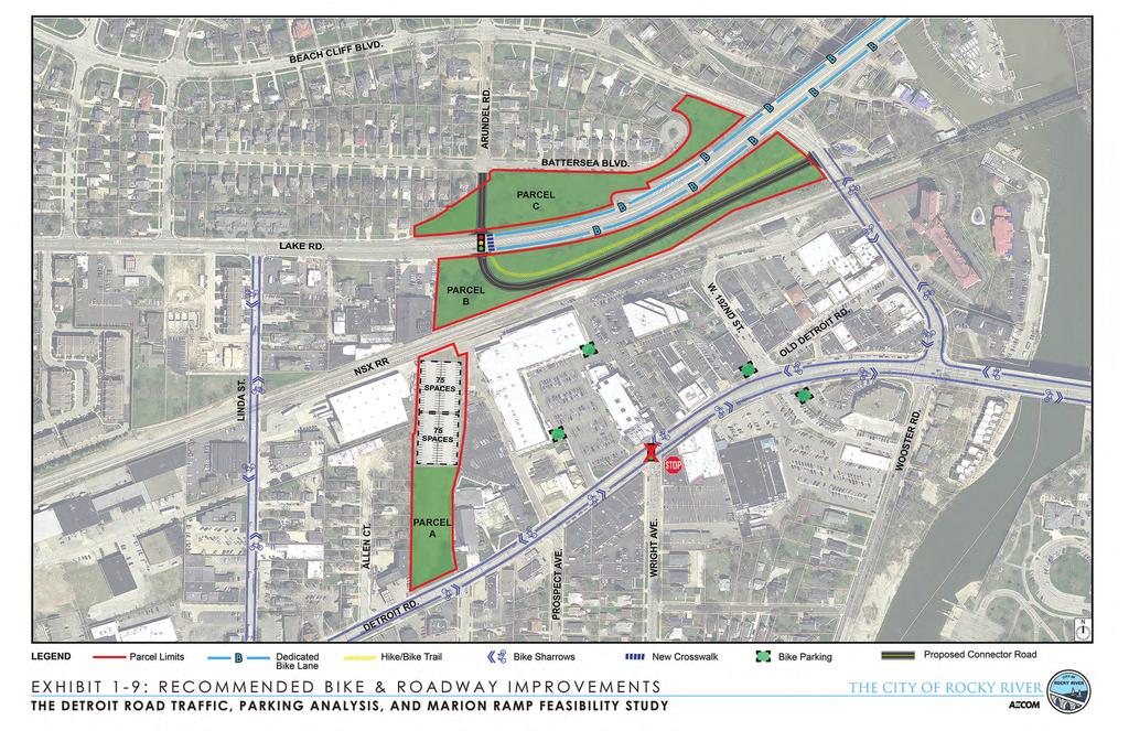
30 The City of Rocky River will need to further investigate the process for undertaking route relocation and plan the work in advance of the initiation of a project that will demolish the structures. Further coordination with ODOT is necessary to advance this change and complete appropriate documentation. 8.4 Land Use Requirements for Land Vacated if Ramps are Removed The removal of the Marion Ramps will create open space in the location that they currently occupy. This land, and the land adjacent to the interchange, including approach roadways and green space, is dedicated public Right of Way, which is owned and maintained by ODOT. Once the infrastructure is removed, ODOT can deed the land to the City of Rocky River with the stipulation that the land be utilized as a civic space. This means that the City can construct and maintain any facilities upon this land which are for public use. With these requirements in mind, alternatives were developed as a part of this study to depict possible uses for this land. Appendix A, Exhibit 1-8 shows three (3) separate parcels with open space that can be utilized. 8.5 Recommendations Although feasible to remove the ramps with respect to traffic impacts, public input was sought to understand the opinion of the community regarding the disposition of the Marion Ramps so that an appropriate recommendation could be determined. Public response to the removal or retainment of the Marion Ramps was not overwhelming for either option. Those in favor of retaining the ramps indicated their preference was due to fear of cut-through traffic on local streets. Those in favor of removing the ramp sited improved safety with the removal of the intersection and signal that exists at the intersection now and the ability to develop green space and additional public parking on the parcel of land previously occupied by the bridge. Due to the lack of significant controversy surrounding the status of the ramps, it is recommended that they be removed and the City move forward with construction of improvements on the vacated parcels. The timing of the bridge and ramp demolitions will be dependent upon available funding for the removals and subsequent improvements coupled with the condition of the structures. With removal imminent, it is likely that ODOT will not invest money in the continued maintenance and rehabilitation of the structures. Their structural capacity and condition will influence the timeframe for removal. Recommendations for improvements on the parcels is as minimal as creating and maintaining green space (grass or other landscaping) until funding becomes available to constructing full improvements over time. These improvements include a Gateway with landscaping on Parcel C, a roadway connection between Lake Road and Beach Cliff Boulevard intersecting at Arundel that would include a hike/bike trail and associated landscaping on Parcel B, and a public parking lot, green space, and on-street parking occupying different portions of Parcel A. Refer to Appendix A, Exhibit 1-9 which depicts these recommendations.
31 Chapter 9: Community Engagement The Marion Ramp Redevelopment and Detroit Road Traffic and Parking Studies were created during a multi-level community engagement program that consisted of civic leaders, a focus group of stakeholders, and the general public. The overall direction of the study was driven by the Rocky River community stakeholders. Their value came into play in guiding the development, providing input, assessing issues, and formulating decisions as the project progressed. In a series of workshops, the stakeholders provided feedback and suggestions while the AECOM team supplied the technical input, analysis, and best practices for the concept and recommendation process. The advisory group included the following individuals and organizations: Liz Manning, Rocky River Chamber of Commerce Jamie Mason, Rocky River Public Library Sam Gifford, Rocky River Schools Mayor Michael P. Summers, City of Lakewood Ryan Noles, NOACA Valerie Shea, GCRTA Brian Blayney and Melinda Bartizal, ODOT District 12 Bill Brink, Beachcliff Market Square John Speilberger, JDS Properties Gregg Mylett, Corporate United Scott Cowan, Century Cycles Frank Eilberg, Marlen Jewelers Reverend Daniel Bogre and Rachel Burns, Rocky River United Methodist Church Joyce Needham, St. Christopher School Michael Mackay, MacKay Engineering (Rocky River City Engineer) Michael O Donnell, Rocky River City Council John Hosek and Lynn Murphy, Rocky River Planning Commission Kate Straub and Jan Thomas, City of Rocky River Andrew D. Bemer, City of Rocky River Law Director Mayor Pam Bobst and Safety-Service Director Mary Kay Costello, City of Rocky River 9.1 Stakeholders Workshops The AECOM team designed and facilitated a series of workshops and provided technical content to stimulate discussion amongst stakeholders. The workshops provided a forum where stakeholders could provide insights and information related to their experiences with traffic, parking, pedestrian and bicycle issues, understand the traffic analysis, review and comment on the direction of the potential designs, and work together with the AECOM team to craft concepts. Four (4) meetings were conducted over the duration of the study. Ultimately, these workshops were useful in establishing the final recommendations for the Marion Ramp and the Detroit Road Corridor. 9.2 Public Meeting The second level of community engagement for the Marion Ramp and Detroit Road Studies was a meeting for the general public. Members of the Rocky River community were invited to participate in an open house style public meeting to introduce the initial plan recommendations and to encourage deeper levels of feedback and ideas from the public. The meeting generated the opportunity to discuss the strengths, weaknesses, and future opportunities within the downtown core.
 stations were set up throughout the room and staffed by team members (Traffic Analysis, Bike and Roadway Improvements, and Parking and Pedestrian Connectivity).")
32 The public meeting held in the evening of May 13, 2015 was well attended. Approximately 70 people were in attendance. A short, formal presentation highlighted the key components of the study. Three (3) stations were set up throughout the room and staffed by team members (Traffic Analysis, Bike and Roadway Improvements, and Parking and Pedestrian Connectivity). In addition, animated traffic analysis (Synchro) models were displayed on a flat screen TV and showed various designed traffic patterns with or without the Marion Ramp. People were encouraged to review the materials, ask questions, and converse in the designated small groups. Multiple means were in place for people to provide comments. Comment cards, phone calls, and s were utilized to communicate suggestions or concerns after the meeting successfully concluded. Approximately twenty-five (25) individuals left a written comment regarding the project. The design consultant team gives a presentation to the stakeholders. Break out Session during Stakeholder Workshop. The main themes as expressed in verbal and written comments are as follows: 1. Support for removing the Marion Ramps Was paired with desire to ameliorate any possible impact of additional traffic on local streets (including: Linda, Morewood, Erie, and Rockland) With special concern about the impact of the opening of the Whole Foods grocery store in September Agreement that more parking for Detroit Road businesses is needed. Several people noted that the proposed parking lot is not as close to the demand areas as would be most desired Concern about Whole Foods impact on parking 3. Enthusiastic support for both improved bike and pedestrian conditions Better bike connections and parking Safer pedestrian crossings and sidewalks 4. Preference to keep the light at Wright and Detroit Avenue 5. Appreciation for the public meeting and the information provided.
33 Chapter 10: Funding Summary 10.1 Identification of Funding Sources per Project Element Work identified in the report includes pavement and bridge removals of the Marion Ramps, curb bumpout installations along Detroit Road including pavement resurfacing and striping, signal modifications at designated intersections including the removal of the Wright Avenue signal and installation of a new signal at Arundel Road and the extension of Arundel Road crossing Lake Avenue then terminating at Beach Cliff Boulevard which may also include an adjacent multi-use trail. It is also anticipated that due to budget constraints of various funding agencies and available funding each fiscal year, the total project would be constructed in a number of short or long term phases. The following are the potential funding programs which are shown in Table 8-1: Transportation Alternative Program (TAP) This is a federal program which requires a 20% non-federal match. Under the federal "community improvement activities" category, projects such as Streetscapes which include the curb bump outs would be eligible under TAP. Also, eligible work items are those related to Road Diets which are projects that remove travel lanes from a roadway and utilize the space for other uses and travel modes. The Marion Ramp removal work would be a candidate for such eligibility. ODOT Urban Paving Program District ODOT offices are allocated funding for resurfacing U.S. or State Routes within municipalities. Funding can be federal or state. The work involves curb to curb resurfacing and requires a 20% local match. Detroit Road (SR 254) is scheduled for resurfacing in the near future and would be an ideal time to install the bumpouts and crosswalk treatments. Surface Transportation Program (STP) This is a federal program which requires a 20% non-federal match. Roadway improvements include resurfacing, rehabilitations, or reconstruction work. Detroit Road and the Marion Ramps are considered federal aid highways and are eligible. Ohio Public Works Commission (OPWC) This is a State Bond program administered by the OPWC. Roadway improvements, bridges, water supply systems, wastewater systems or storm water collection systems are typical eligible projects. OPWC monies can also be used to provide the non-federal match on eligible projects. State Infrastructure Banks (SIB) This is a short or long term low interest loan program administered by ODOT for eligible highway or transit projects. Work identified in this study would be considered eligible for a SIB loan. Surface Water Improvement Fund (SWIF) Clean Water Act Section 319 (319 Grants) These are potential Ohio EPA programs that funding may be available depending on the final design elements of the projects.
34 The TA and STP program projects are selected by the local Metropolitan Planning Organizations (MPO s), which is NOACA. Projects are selected by the NOACA Board through a competitive application process. Other programs are typically administered by the ODOT District offices who select the projects to be funded. The regional District 12 office should also be interested in participating in the Marion Ramp removals, as the project would eliminate a bridge under their maintenance jurisdiction including the approach pavement. The removal of this infrastructure would result in a cost savings on their future repair. Table 10-1: Potential Funding Sources Work Items Marion Ramp removals Arundel Road extension Detroit curb bump outs Hike/Bike trail Detroit Resurfacing/striping Signal upgrades Wayfinding signage Bike Lanes New public parking lot Excess land parcels TAP STP Urban Paving OPWC SIB ODOT D12 City X X X X X X X X X X X X X X X X X X X X X X X X X X X X X X X X X X
35 Chapter 11: Cost Estimate of Short, Medium, and Long Term Recommendations Short-term Improvements: (0 2) years 1. Resurface Detroit Road ODOT Urban Paving Funds to cover. City cost for upgrading to thermoplastic pavement markings if ODOT will not provide is $45, Upgrade various project signals to include protected left-turn movements a. Thirteen intersections where traffic signals are replaced with LED lights and backplates) and new pedestrian signals are installed $14,500 per intersection. b. Removal of signal at Wright Avenue $6,500 c. Left-turn signal head at Wagar Road City has already installed d. Removal of signal at Marion Ramps $6, Revise signal timings for better vehicular and pedestrian operations $10, Add Sharrows and associated signage to Detroit Road and Beach Cliff $30, Improve parking by preparing a parking wayfinding plan to educate patrons $55,000 for consultation and fabrication of signage for the program 6. Place bicycle racks along Detroit Road $12, Improve/sign bicycle connections at Eldora Road and Dorothy Avenue pavement markings and clearing $2,500 (or executed by City forces) Mid-term Improvements: (3 5) years 1. Provide pedestrian bump outs along Detroit Road and decorative crosswalks $200, Improve curb ramps at intersections thirteen intersections $6,000 per intersection 3. Provide mid-block pedestrian crossings (stamped concrete) with Rectangular Rapid Flash Beacons (RRFB s) on Detroit, east and west of Wright Avenue and across Linda Street $20,000 per location 4. Reduce Clifton Avenue to one lane in each direction over bridge to provide bike lanes $30,000 for pavement markings Long-term Improvements: (5+) years 1. Remove the Marion Ramps, grade and provide basic landscape areas adjacent to Lake Road a. Removal of the structure $525,000 b. Regrade and landscape Parcel A $40,000 c. Landscape Parcel B $60,000 d. Landscape Parcel C $60, Re-route SR2 from Marion Ramp to coincide with US20 along West Clifton Boulevard and Sloane Avenue - $50,000 to perform required study and remove and re-erect signage 3. Construct new Arundel Road intersection and connector road to Lake Road and upgrade road/ramp to Beach Cliff Blvd, including trail $500, Provide additional parking along Detroit and behind Beachcliff Market Square in area vacated by Marion Ramps $75,000/ (50 Spaces) 5. Connect Beachcliff area to the Linda Street Corridor $350,000 plus land acquisition costs 6. Construct a streetscape project that upgrades the existing signals along Detroit Road to new decorative mast arms with all new signal and pedestrian heads. Also, provide additional roadside amenities such as street trees, benches and trash receptacles. e. Signals $135,000 per intersection f. Streetscape $50, Construct a new pedestrian bridge spanning the Norfolk Southern (NS) railroad tracks including approach from north (and assuming embankment to the south is already in place) $1,000,000
36 Appendix A: Exhibits

37

38

39
40

41

42

43

44
45
46 Appendix B: Bridge Condition Report


47 MARION RAMPS BRIDGE ASSESSMENT REPORT MARION RAMPS BRIDGE ASSESSMENT REPORT City of Rocky River, Ohio Prepared by: URS Corporation For: City of Rocky River, Ohio Structure File Numbers: , , & Cuyahoga County, Ohio October, 2014 Rocky River, Ohio 1
48 MARION RAMPS BRIDGE ASSESSMENT REPORT EXECUTIVE SUMMARY This Bridge Assessment Report has been prepared to document the existing condition of the Marion Ramp Bridges in Rocky River, Ohio. Also included is an assessment of the bridges based upon review of the latest BR-86 reports and visual structure inspection of the respective structures. The visual inspection of the structures along with review of the prior BR-86 inspection reports has revealed that the structures are in dire need of overlay replacement, superstructure concrete patching, substructure concrete patching, bearing rehabilitation, and approach slab rehabilitation. It is URS professional opinion that these rehabilitations should be completed within five years to prevent the structures from degrading further. Finally, a Life Cycle Cost Analysis has been performed to project maintenance and repair costs into the future. Rocky River, Ohio 2


49 MARION RAMPS BRIDGE ASSESSMENT REPORT STUDY LOCATION The Marion Ramps are located on the eastern border of the City of Rocky River, Ohio. They are located just west of the Rocky River on U.S. Route 6 as shown in Figures 1 and 2 below. Figure 1 Marion Ramps, Rocky River, OH. Figure 2 Close-up of Marion Ramps, Rocky River, OH. Rocky River, Ohio 3
50 MARION RAMPS BRIDGE ASSESSMENT REPORT EXISTING BRIDGES The existing ramp system provides access to and from U.S. Route 6 (Clifton Boulevard/Lake Street) along S.R. 2. Ramp A of the ramp system carries westbound (WB) U.S. Route 6 on a fly-over ramp over U.S. Route 6 and Ramp C, then NSRR parallel to Parson s Court along State Route 2. Ramp B carries eastbound State Route 2 parallel to Parson s Court over Norfork & Southern Railroad (NSRR) and Ramp C and ultimately joins with U.S. Route 6. Ramp C carries U.S. Route 6 EB traffic to a T-intersection at West Lake Rd./Beach Cliff Blvd. Ramp D carries West Lake Rd./Beach Cliff Blvd. traffic onto U.S. Route 6 WB. The ramp system is shown schematically in Figure 3 below. FIGURE 3 Schematic Plan of Marion Ramp System There are three (3) bridges associated with the ramp system: 1) CUY Ramp A and B of S.R. 2 over NSRR, SFN: ) CUY L Ramp A of S.R. 2 over U.S. Route 6, SFN: ) CUY R Ramp B of S.R. 2 over Ramp C, SFN: Note: SFN = Structure File Number for the Ohio Department of Transportation (ODOT) bridge inventory and recording. Rocky River, Ohio 4
51 MARION RAMPS BRIDGE ASSESSMENT REPORT Bridge No CUY (SFN: ) This structure consists of two (2) continuous spans of non-composite W36 steel beams (7 lines) supported on full-height, reinforced concrete abutments and a center T-type cantilever pier, all supported on spread footings founded on shale. The skew is 26⁰26 10 right forward to align with the NSRR underneath Ramps A and B. Span lengths are 60-6 and The structure is on a horizontal tangent alignment with a flared geometry at the north end to accommodate Ramp B diverging away from Ramp A. The flared geometry is framed by using variable spacing for the longitudinal beams along with a header beam when beam lines get too close. The structure is of variable width (28 roadway minimum, and increasing to the north) with 2-3 safety curbs and concrete parapet with aluminum pipe railing. The structure was designed in 1962 by HNTB and constructed in In 1993, a rehabilitation (designed in 1991 by Richland Engineering, Ltd.) was performed on the structure with the following modifications: 1) Micro-silica modified concrete overlay (2-3/4 thick). 2) Structural expansion joint with elastomeric strip seal. 3) Substructure concrete patching. 4) New reinforced concrete backwalls and approach slabs. 5) OZEU painting of all structural steel. 6) Repair curbs/railings and epoxy sealing of exposed concrete surfaces. Bridge No CUY L (SFN: ) This structure consists of three (3) continuous spans of cast-in-place, reinforced concrete box girder (3 celled) supported on stub-type, reinforced concrete abutments founded on steel HP piles driven to shale, and two (2) single column reinforced concrete piers built integrally into the superstructure girders and founded on spread footings bearing on shale. The skew is 0⁰ Span lengths are 64, 116, and 64. The structure is on a horizontal curved alignment of 18⁰ curve. The structure has a 19 roadway width with 2-3 safety curbs and concrete parapet with aluminum pipe railing for a total width of out-toout. The structure was designed in 1962 by HNTB and constructed in In 1993, a rehabilitation (designed in 1991 by Richland Engineering, Ltd.) was performed on the structure with the following modifications: 1) Micro-silica modified concrete overlay (2-3/4 thick). 2) Structural expansion joint with elastomeric compression seal. 3) Superstructure girder patching (along with temporary support of girders). 4) Substructure concrete patching. 5) New reinforced concrete backwalls and approach slabs. 6) Repair curbs/railings and epoxy sealing of exposed concrete surfaces. Rocky River, Ohio 5
52 MARION RAMPS BRIDGE ASSESSMENT REPORT Bridge No CUY R (SFN: ) This structure consists of three (3) continuous spans of cast-in-place, reinforced concrete box girder (3 celled) supported on stub-type, reinforced concrete abutments founded on steel HP piles driven to shale, and two (2) single column reinforced concrete piers built integrally into the superstructure girders and founded on spread footings bearing on shale. The skew is 0⁰ Span lengths are 56, 70, and 56. The structure is on a tangent horizontal alignment. The structure has a 19 roadway width with 2-3 safety curbs and concrete parapet with aluminum pipe railing for a total width of out-to-out. The structure was originally designed in 1962 by HNTB and constructed in In 1993, a rehabilitation (designed in 1991 by Richland Engineering, Ltd.) was performed on the structure with the following modifications: 1) Micro-silica modified concrete overlay (2-3/4 thick). 2) Structural expansion joint with elastomeric compression seal. 3) Superstructure girder patching (along with temporary support of girders). 4) Substructure concrete patching. 5) New reinforced concrete backwalls and approach slabs. 6) Repair curbs/railings and epoxy sealing of exposed concrete surfaces. Rocky River, Ohio 6
53 MARION RAMPS BRIDGE ASSESSMENT REPORT BRIDGE CONDITION RATINGS The most recent BR-86 Inspection Reports were obtained and reviewed. The BR-86 reports for the respective structures are included in Appendix A. Bridge No CUY (SFN: ) According to the latest ODOT BR-86 inspection (6/13/13), the Deck Summary is 6, Superstructure Summary is 7, Substructure Summary is 6 and General Appraisal is 6 (all on a 1 to 9 scale with 9 being new condition). These ratings are generally typical and expected for a bridge of this age and type of construction. Bridge No CUY L (SFN: ) According to the latest ODOT BR-86 inspection (12/5/13), the Deck Summary is 7, Superstructure Summary is 6, Substructure Summary is 7 and General Appraisal is 6 (all on a 1 to 9 scale with 9 being new condition). These ratings are generally typical and expected for a bridge of this age and type of construction. Bridge No CUY R (SFN: ) According to the latest ODOT BR-86 inspection (12/5/13), the Deck Summary is 7, Superstructure Summary is 7, Substructure Summary is 7 and General Appraisal is 7 (all on a 1 to 9 scale with 9 being new condition). These ratings are generally typical and expected for a bridge of this age and type of construction. Rocky River, Ohio 7
54 MARION RAMPS BRIDGE ASSESSMENT REPORT EXISTING BRIDGE CONDITION On October 7, 2014, URS bridge engineers accessed the site for a visual inspection to determine the condition of the Marion Ramp Bridges. The photographs that follow are intended to document the current condition of the subject bridges. Bridge No CUY (SFN: ) PHOTOGRAPH 1 shows a view of the structure looking west. PHOTOGRAPH 2 shows a view from north of the bridge looking south. PHOTOGRAPH 3 shows a view from south of the bridge looking north. PHOTOGRAPH 4 shows a view from the structure looking west along the NSRR tracks. PHOTOGRAPH 5 shows a view from the structure looking east along the NSRR tracks. PHOTOGRAPH 6 shows a view of the south abutment. PHOTOGRAPH 7 shows a view of the north abutment. PHOTOGRAPH 8 shows a view of the northeast wingwall and PHOTOGRAPH 9 shows a view of the northwest wingwall. As seen in these photos, the abutments are in general good condition and require only minor patching in the near future. PHOTOGRAPH 10 shows a view of the center pier. As seen in this photo, the pier is in general good condition. PHOTOGRAPHS 11 through 13 show the condition of the beams and bottom of the deck at the north abutment, south abutment and center pier, respectively. The photos show the general good condition of the beams and the general good condition of the paint system. The bottom of the deck is in general fair condition with dark staining and spalls to rebar with corroding rebar in various areas. PHOTOGRAPH 14 shows the general condition of the top deck at the northeast corner of the deck. PHOTOGRAPH 15 shows the general condition of the top deck at the gore area between Ramps A and B at the north end of the deck. PHOTOGRAPH 16 shows the general condition of the top deck at the south expansion joint; note the significant spalling of the overlay and failure of the joint at the backwall to approach slab joint. The overlay is map cracked throughout with significant wet stains throughout. There is also significant spalling adjacent to the expansion joint. Due to the condition and age of the overlay, it is estimated that it will need replacement with the next five years. The safety curbs and parapets will also need replacement or rehabilitation in the same timeframe. The approach slabs will likewise need replacement or rehabilitation within the next five years. Rocky River, Ohio 8
55 MARION RAMPS BRIDGE ASSESSMENT REPORT Bridge No CUY L (SFN: ) PHOTOGRAPH 17 shows a view of the structure looking east. PHOTOGRAPH 18 shows a view of the structure looking west. PHOTOGRAPH 19 shows a view from the structure looking west along U.S. Route 6. PHOTOGRAPH 20 shows a view from the structure looking east along U.S. Route 6. PHOTOGRAPH 21 shows a view from south of the bridge looking north. PHOTOGRAPH 22 shows a view from north of the bridge looking south. PHOTOGRAPH 23 shows a view of the north abutment and NW bearing. Note the spall on the abutment with exposed rebar. Also note the rusted condition of the rocker bearing. PHOTOGRAPH 24 shows a view of the south abutment. Note the spalls on the abutment and shear key. Also note the rusted condition of the exterior bearings. PHOTOGRAPH 25 shows a view of the North Pier column and underside of the concrete girders. These are in general good condition. There are, however, localized areas of damage to the deck underside, as seen in PHOTOGRAPH 26 which shows a view of concrete box girder spalling with exposed rebar just east of the south pier. PHOTOGRAPH 27 shows a view of spalling concrete with exposed deck rebar at the southeast corner of the deck overhang. PHOTOGRAPH 28 shows the deteriorated condition of the reinforced concrete safety curbs. Also note the rust staining of the curb plates. PHOTOGRAPH 29 shows typical parapet cracking as well as spalling of the overlay at the deck joint. Due to the condition and age of the overlay, it is estimated that it will need replacement within the next five years. The safety curbs and parapets will also need replacement or rehabilitation in the same timeframe. PHOTOGRAPH 30 shows the typical vegetative growth at approach slab gutterlines. The approach slabs will likewise need replacement or rehabilitation within the next five years. Bridge No CUY R (SFN: ) PHOTOGRAPH 31 shows a view of the structure looking south. PHOTOGRAPH 32 shows a view of the structure looking northwest along Ramp C. PHOTOGRAPH 33 shows a view from the structure looking northwest along Ramp C. PHOTOGRAPH 34 shows a view from the structure looking southeast along Ramp C. PHOTOGRAPH 35 shows a view from west of the bridge looking east. PHOTOGRAPH 36 shows a view from east of the bridge looking west. PHOTOGRAPH 37 shows a view of the west abutment and southwest exterior bearing. Note the rusted condition of the exterior bearings. PHOTOGRAPH 38 shows a repair patch from the 1991 Rehabilitation that has delaminated and will fail in the near future. PHOTOGRAPH 39 shows a repair patch from the 1991 Rehabilitation that has delaminated from the end of Rocky River, Ohio 9
56 MARION RAMPS BRIDGE ASSESSMENT REPORT the concrete girder at the southeast corner of the bridge. Also note the rusted condition of the exterior bearings. PHOTOGRAPH 40 shows a view of the East Pier column and underside of the concrete girders. These are in general good condition. PHOTOGRAPH 41 shows the deteriorated condition of the reinforced concrete safety curbs. PHOTOGRAPH 42 shows the map cracking of the map cracking of the microsilica modified concrete overlay. Note also the rusted condition of the curb plates as well as rust staining on the parapet from corroding rebar at parapet cracks. PHOTOGRAPH 43 shows the general condition of the deck joints. Note the spalling of the overlay adjacent to the deck joints. Due to the condition and age of the overlay, it is estimated that it will need replacement within the next five years. The safety curbs and parapets will also need replacement or rehabilitation in the same timeframe. PHOTOGRAPH 43 shows the typical vegetative growth at the approach slab gutterlines. The approach slabs will likewise need replacement or rehabilitation with the next five years. DEFINITIONS OF BRIDGE INSPECTIONS The bridge inspections provided under this report were performed in accordance with the Ohio Department of Transportation Manual of Bridge Inspection, dated 1973 and revised in 2014 (the Manual ). Notwithstanding anything additional or contrary contained in the Manual, Routine and In-Depth Inspections for the purposes of the services provided by URS under this report are defined as follows: ROUTINE INSPECTIONS The Routine inspections consist of visual observations to identify observed changes from initial or previously recorded conditions, and to analyze whether the structure continues to satisfy present service requirements based on observations made by URS. These visual observations are made from accessible positions on the ground or the bridge deck. Ladders or man-lift equipment is not used. VISUAL INSPECTIONS For purposes of this report, Visual Inspections are synonymous with Routine Inspection defined above. Rocky River, Ohio 10

 Rocky")
57 MARION RAMPS BRIDGE ASSESSMENT REPORT PHOTOGRAPH 1 CUY West Elevation (Looking West) PHOTOGRAPH 2 CUY Through Bridge (Looking South) Rocky River, Ohio 11

 Rocky River,")
58 MARION RAMPS BRIDGE ASSESSMENT REPORT PHOTOGRAPH 3 CUY Through Bridge (Looking North) PHOTOGRAPH 4 CUY On Bridge (Looking West) Rocky River, Ohio 12

 Rocky")
59 MARION RAMPS BRIDGE ASSESSMENT REPORT PHOTOGRAPH 5 CUY On Bridge (Looking East) PHOTOGRAPH 6 CUY South Abutment (Looking Southwest) Rocky River, Ohio 13

")
60 MARION RAMPS BRIDGE ASSESSMENT REPORT PHOTOGRAPH 7 CUY North Abutment (Looking North) PHOTOGRAPH 8 CUY Northeast Wingwall (Looking Northeast) Rocky River, Ohio 14

 Rocky")
61 MARION RAMPS BRIDGE ASSESSMENT REPORT PHOTOGRAPH 9 CUY Northwest Wingwall (Looking North) PHOTOGRAPH 10 CUY Center Pier (Looking Northwest) Rocky River, Ohio 15

")
62 MARION RAMPS BRIDGE ASSESSMENT REPORT PHOTOGRAPH 11 CUY View of Beams and Bottom of Deck at North Abutment (Looking North) PHOTOGRAPH 12 CUY View of Beams and Bottom of Deck at South Abutment (Looking South) Rocky River, Ohio 16

 Rocky River,")
63 MARION RAMPS BRIDGE ASSESSMENT REPORT PHOTOGRAPH 13 CUY View of Beams and Bottom of Deck at Center Pier (Looking North) PHOTOGRAPH 14 CUY View of Top of Deck at NE Corner (Looking West) Rocky River, Ohio 17

 Rocky River,")
64 MARION RAMPS BRIDGE ASSESSMENT REPORT PHOTOGRAPH 15 CUY View of Top Deck at Gore Area at North End (Looking West) PHOTOGRAPH 16 CUY View of Top Deck at South End (Looking West) Rocky River, Ohio 18

 Rocky River,")
65 MARION RAMPS BRIDGE ASSESSMENT REPORT PHOTOGRAPH 17 CUY L West Elevation (Looking East) PHOTOGRAPH 18 CUY L East Elevation (Looking West) Rocky River, Ohio 19


66 MARION RAMPS BRIDGE ASSESSMENT REPORT PHOTOGRAPH 19 CUY L On Bridge (Looking West along U.S. Route 6) PHOTOGRAPH 20 CUY L On Bridge (Looking East along U.S. Route 6) Rocky River, Ohio 20

 Rocky")
67 MARION RAMPS BRIDGE ASSESSMENT REPORT PHOTOGRAPH 21 CUY L Through Bridge (Looking North) PHOTOGRAPH 22 CUY L Through Bridge (Looking South) Rocky River, Ohio 21


68 MARION RAMPS BRIDGE ASSESSMENT REPORT PHOTOGRAPH 23 CUY L North Abutment/Bearing (Looking North) PHOTOGRAPH 24 CUY L South Abutment/Bearings (Looking South) Rocky River, Ohio 22


69 MARION RAMPS BRIDGE ASSESSMENT REPORT PHOTOGRAPH 25 CUY L North Pier and Concrete Girder Bottom (Looking South) PHOTOGRAPH 26 CUY L Concrete Girder Spalling just East of South Pier Rocky River, Ohio 23


70 MARION RAMPS BRIDGE ASSESSMENT REPORT PHOTOGRAPH 27 CUY L Spalling/Exposed Rebar at Southeast corner at Deck Overhang PHOTOGRAPH 28 CUY L Typical Safety Curb Spalling and Deterioration Rocky River, Ohio 24


71 MARION RAMPS BRIDGE ASSESSMENT REPORT PHOTOGRAPH 29 CUY L Typical Parapet Cracking and Spalling of Overlay at Deck Joint PHOTOGRAPH 30 CUY L Typical Vegetative Growth at Approach Slab Gutterline Rocky River, Ohio 25

")
72 MARION RAMPS BRIDGE ASSESSMENT REPORT PHOTOGRAPH 31 CUY R North Elevation (Looking South) PHOTOGRAPH 32 CUY R South Elevation (Looking Northwest Along Ramp C) Rocky River, Ohio 26

 Rocky")
73 MARION RAMPS BRIDGE ASSESSMENT REPORT PHOTOGRAPH 33 CUY R On Bridge (Looking Northwest Along Ramp C) PHOTOGRAPH 34 CUY R On Bridge (Looking Southeast Along Ramp C) Rocky River, Ohio 27

 Rocky River,")
74 MARION RAMPS BRIDGE ASSESSMENT REPORT PHOTOGRAPH 35 CUY R Through Bridge (Looking East) PHOTOGRAPH 36 CUY R Through Bridge (Looking West) Rocky River, Ohio 28
")
 Rocky River, Ohio")
75 MARION RAMPS BRIDGE ASSESSMENT REPORT PHOTOGRAPH 37 CUY R West Abutment/Bearings (Looking West) PHOTOGRAPH 38 CUY R Delaminated Repair Patch at SW Corner (Looking Northeast) Rocky River, Ohio 29

 Rocky")
76 MARION RAMPS BRIDGE ASSESSMENT REPORT PHOTOGRAPH 39 CUY R Spalled Repair Patch at SE Corner/Rusted Bearings (Looking East) PHOTOGRAPH 40 CUY R East Pier Column (Looking West) Rocky River, Ohio 30


77 MARION RAMPS BRIDGE ASSESSMENT REPORT PHOTOGRAPH 41 CUY R Typical Safety Curb Spalling and Deterioration PHOTOGRAPH 42 CUY R Typical Overlay Map Cracking Rocky River, Ohio 31


78 MARION RAMPS BRIDGE ASSESSMENT REPORT PHOTOGRAPH 43 CUY R Typical Parapet Cracking and Spalling of Overlay at Deck Joint PHOTOGRAPH 44 CUY R Typical Vegetative Growth at Approach Slab Gutterline Rocky River, Ohio 32
79 MARION RAMPS BRIDGE ASSESSMENT REPORT LIFE CYCLE COST ANALYSIS The review of BR-86 Inspection Reports, supplemented with URS visual inspection of the Marion Ramp Bridges has determined that the bridges are in need of rehabilitation to extend the usable life of the bridges. For planning purposes, the Marion Ramp Bridges are ahead of typical ODOT bridges in that the Marion Ramp Bridges are currently 50 years old and on their first overlay rehabilitation, which is currently 21 years old. In general terms, ODOT typically gets 45 to 50 years out of a bridge superstructure. This would have slated the bridges for total superstructure replacement at a point not too far into the future. However, due to the low traffic and truck cycles on the bridge, the bridge is lasting longer than typical ODOT planning estimates. Based on the past history and current condition of the Marion Ramp Bridges, it is our opinion that an overlay and general rehabilitation contract should be completed by year 2020 (within the next five years) to extend the useful life of the Marion Ramp Bridges. Based on current ODOT planning estimates, this overlay should last until year At year 2035, the bridge deck and superstructure will need replacement. This new superstructure is expected to last for 50 years, putting the useful life of the bridge to year At this point, the structures will require total replacement. Note, based on current and past traffic/truck counts, the rehabilitation may last beyond year 2035, however, it is prudent to maintain realistic estimates for planning purposes. ALTERNATIVE 1 KEEP CURRENT CONFIGURATION AND EXTEND USEFUL LIFE OF RAMP SYSTEM YEAR 2020 REHABILITATION ESTIMATE OF PROBABLE CONSTRUCTION COST The rehabilitations for repairing the Marion Ramp Bridges is projected to cost $400,000 (in 2014 dollars). This includes $15/SF for the removal of the existing overlays and construction of new overlays. Also included is replacement of concrete safety curbs and railings, as well as miscellaneous repairs, including bearing retrofits, substructure concrete patching and superstructure concrete patching. YEAR 2035 SUPERSTRUCTURE REPLACEMENT ESTIMATE OF PROBABLE CONSTRUCTION COST The superstructures will need to be replaced in year 2035 to extend the structure life to year It is estimated that this replacement will cost $1,500,000 (in 2014 dollars). This includes $75/SF for removal and replacement of steel beams and/or concrete beams and new decks. Also included are miscellaneous repairs. These repairs, along with another overlay rehabilitation in year 2060 (estimated at $400,000 in 2014 dollars) will extend the useful life of the structures to year Rocky River, Ohio 33
80 MARION RAMPS BRIDGE ASSESSMENT REPORT ALTERNATIVE 2 REMOVE EXISTING RAMP SYSTEM Removing the existing Marion Ramp System will save considerable maintenance dollars, provided the need for the ramp system is not required. YEAR 2015 REMOVAL OF RAMP SYSTEM ESTIMATE OF PROBABLE CONSTRUCTION COST The removal of the Marion Ramp Bridges is estimated to cost $500,000 (in 2014 dollars). This includes removal of all exposed structural elements of the bridges and removal of substructures to 1 below current grade. It does not include earthwork or land grading beyond that necessary to remove the structures. ALTERNATIVE 3 REMOVE EXISTING RAMP SYSTEM AND PROVIDE PEDESTRIAN/BICYCLE BRIDGE OVER NSRR The traffic study has indicated that pedestrian and bicycle traffic over the NSRR is desirable. This alternative includes pricing to remove the existing Marion Ramp Bridges and construct a pedestrian/bicycle bridge on the existing substructures over the NSRR. YEAR 2015 REMOVAL OF RAMPS AND NEW PEDESTRIAN BRIDGE ESTIMATE OF PROBABLE CONSTRUCTION COST The alternative is projected to cost $750,000 (in 2014 dollars). This includes removal of all exposed structural elements of the bridges and removal of substructures to 1 below current grade. It also includes constructing a prefabricated pedestrian structure across the NSRR on existing rehabilitated substructures. Rocky River, Ohio 34
81 MARION RAMPS BRIDGE ASSESSMENT REPORT Appendices APPENDIX A BR-86 INSPECTION REPORTS Rocky River, Ohio 35

82 MARION RAMPS BRIDGE ASSESSMENT REPORT Appendices FIGURE A-1 BR-86 Inspection Report Bridge No. CUY Rocky River, Ohio 36

83 MARION RAMPS BRIDGE ASSESSMENT REPORT Appendices FIGURE A-2 BR-86 Inspection Report Bridge No. CUY L Rocky River, Ohio 37

84 MARION RAMPS BRIDGE ASSESSMENT REPORT Appendices FIGURE A-3 BR-86 Inspection Report Bridge No. CUY R Rocky River, Ohio 38
APPENDIX 2 LAKESHORE ROAD TRANSPORTATION REVIEW STUDY EXECUTIVE SUMMARY
 APPENDIX 2 LAKESHORE ROAD TRANSPORTATION REVIEW STUDY EXECUTIVE SUMMARY Appendix 2 City of Mississauga Lakeshore Road FINAL REPORT Transportation Review Study December 2010 EXECUTIVE SUMMARY Study Purpose
Solana Beach Comprehensive Active Transportation Strategy (CATS)
") Solana Beach Comprehensive Active Transportation Strategy (CATS) 3.0 Goals & Policies The Solana Beach CATS goals and objectives outlined below were largely drawn from the Solana Beach Circulation Element
Solana Beach Comprehensive Active Transportation Strategy (CATS) 3.0 Goals & Policies The Solana Beach CATS goals and objectives outlined below were largely drawn from the Solana Beach Circulation Element
Duwamish Way-finding and CTR Report
 V. North Tukwila When the North Tukwila Manufacturing and Industrial Center was designated in 1992 as part of the region s land use and transportation plan, the plan called for the area to set a light-rail
Goodlettsville Bicycle and Pedestrian Plan Executive Summary
 Goodlettsville Bicycle and Pedestrian Plan July 2010 In Cooperation with the Nashville Area Metropolitan Planning Executive Organization Summary Introduction Progressive and forward thinking communities
Chapter 5 Future Transportation
 Chapter 5 Future Transportation The Future Land Use Plan identifies the desired land use designations. The land uses desired for Crozet depend, in large part, on the success of the transportation system,
APPENDIX A: Complete Streets Checklist DRAFT NOVEMBER 2016
 APPENDIX A: Complete Streets Checklist DRAFT NOVEMBER 2016 Complete Streets Checklist MetroPlan Orlando s Complete Streets Checklist is an internal planning tool for staff to further implementation of
BETHEL ROAD AND SEDGWICK ROAD CORRIDOR STUDY
 DRAFT PLAN City Council Meeting August 14, 2017 STUDY AREA Sedgwick Corridor State Route 160, principal arterial with Class 3 access management designation, commuter and freight route, connection to SR
Route 7 Corridor Study
 Route 7 Corridor Study Executive Summary Study Area The following report analyzes a segment of the Virginia State Route 7 corridor. The corridor study area, spanning over 5 miles in length, is a multi
Chapter 2: Standards for Access, Non-Motorized, and Transit
 Standards for Access, Non-Motorized, and Transit Chapter 2: Standards for Access, Non-Motorized, and Transit The Washtenaw County Access Management Plan was developed based on the analysis of existing
CONNECTIVITY PLAN. Adopted December 5, 2017 City of Virginia Beach
 CONNECTIVITY PLAN Adopted December 5, 2017 City of Virginia Beach CONTENTS 1.0 Background & Purpose... 2 2.0 Existing Inventory & Analysis... 3 ViBe District Existing Walking Conditions... 4 3.0 ViBe District
NJDOT Complete Streets Checklist
 Background The New Jersey Department of Transportation s Complete Streets Policy promotes a comprehensive, integrated, connected multi-modal network by providing connections to bicycling and walking trip
S T A T I O N A R E A P L A N
 The Circulation and Access Plan describes vehicle, pedestrian, and transit improvements recommended within the Concept Plan. In order to create and sustain a vibrant business district that provides pedestrian-friendly
ACTIVE TRANSPORTATION
 ACTIVE TRANSPORTATION Mobility 2040 Supported Goals Improve the availability of transportation options for people and goods. Support travel efficiency measures and system enhancements targeted at congestion
CITY OF COCOA BEACH 2025 COMPREHENSIVE PLAN. Section VIII Mobility Element Goals, Objectives, and Policies
 CITY OF COCOA BEACH 2025 COMPREHENSIVE PLAN Section VIII Mobility Element Goals, Objectives, and Policies Adopted August 6, 2015 by Ordinance No. 1591 VIII MOBILITY ELEMENT Table of Contents Page Number
ROUTE 81 CORRIDOR STUDY DESIGN CONCEPTS
 RT 81 Corridor Study CLINTON ROUTE 81 CORRIDOR STUDY DESIGN CONCEPTS View north on High Street, with potential improvements to the streetscape Draft Recommendations November 8 th, 2018 TOWN OF CLINTON
DOWNTOWN TUPELO MAIN STREET: ROAD DIET STUDY
 DOWNTOWN TUPELO MAIN STREET: ROAD DIET STUDY Since mid-2009, RPM Transportation Consultants (RPM) has worked with the Downtown Tupelo Main Street Association to evaluate traffic conditions and potential
CONNECTING PEOPLE TO PLACES
 CONNECTING PEOPLE TO PLACES 82 EAST BENCH MASTER PLAN 07 Introduction The East Bench transportation system is a collection of slow moving, treelined residential streets and major arteries that are the
EUCLID AVENUE PARKING STUDY CITY OF SYRACUSE, ONONDAGA COUNTY, NEW YORK
 EUCLID AVENUE PARKING STUDY CITY OF SYRACUSE, ONONDAGA COUNTY, NEW YORK CITY OF SYRACUSE DEPARTMENT OF PUBLIC WORKS 1200 CANAL STREET EXTENSION SYRACUSE, NEW YORK 13210 DRAFT REPORT DATE: November 13,
City of Gainesville Transportation/Roadway Needs PROJECT SUMMARY
 A1 Roadway Resurfacing $23,846,000 TYPE: Preservation of existing system Roadway resurfacing A2 Signal Replacement $6,000,000 TYPE: Preservation of existing system Replace traffic signals. B1 W 6th St
Highway 111 Corridor Study
 Highway 111 Corridor Study June, 2009 LINCOLN CO. HWY 111 CORRIDOR STUDY Draft Study Tea, South Dakota Prepared for City of Tea Sioux Falls Metropolitan Planning Organization Prepared by HDR Engineering,
Downtown BRT Corridor Alternatives Review: 1 st, 2 nd, 3 rd and 4 th Avenue. Bus Rapid and Conventional Transit Planning and Design Services
 Downtown BRT Corridor Alternatives Review: 1 st, 2 nd, 3 rd and 4 th Avenue Bus Rapid and Conventional Transit Planning and Design Services City of Saskatoon February 2018 Project Team HDR Corporation
Non-Motorized Transportation 7-1
 Non-Motorized Transportation 7-1 Transportation facilities no longer mean just accommodating a vehicle powered by a combustion engine. Pedestrian and non-motorized facilities are important modes of travel
THIS PAGE LEFT BLANK INTENTIONALLY
 GA SR 25 Spur at Canal Road Transportation Impact Analysis PREPARED FOR GLYNN COUNTY, GEORGIA 1725 Reynolds Street, Suite 300 Brunswick, Georgia 31520 PREPARED BY 217 Arrowhead Boulevard Suite 26 Jonesboro,
Broad Street Bicycle Boulevard Design Guidelines
 Broad Street Bicycle Boulevard Design Guidelines Building from the strategies introduced in the 2013 Bicycle Transportation Plan and community input received thus far, City Transportation Staff have identified
DRAFT - CITY OF MEDFORD TRANSPORTATION SYSTEM PLAN Roadway Cross-Sections
 Roadway Cross-Sections Medford s roadway cross-section standards apply to new and reconstructed roads. The crosssections take into consideration roadway function and operational characteristics, including
Bicycle Master Plan Goals, Strategies, and Policies
 Bicycle Master Plan Goals, Strategies, and Policies Mobilizing 5 This chapter outlines the overarching goals, action statements, and action items Long Beach will take in order to achieve its vision of
Active Transportation Facility Glossary
 Active Transportation Facility Glossary This document defines different active transportation facilities and suggests appropriate corridor types. Click on a facility type to jump to its definition. Bike
5858 N COLLEGE, LLC N College Avenue Traffic Impact Study
 5858 N COLLEGE, LLC nue Traffic Impact Study August 22, 2016 Contents Traffic Impact Study Page Preparer Qualifications... 1 Introduction... 2 Existing Roadway Conditions... 5 Existing Traffic Conditions...
Dr. M.L. King, Jr. Street North Complete Streets Resurfacing Opportunities HOUSING, LAND USE, AND TRANSPORTATION COMMITTEE MARCH 22, 2018
 Dr. M.L. King, Jr. Street North Complete Streets Resurfacing Opportunities HOUSING, LAND USE, AND TRANSPORTATION COMMITTEE MARCH 22, 2018 What s Happening The City plans to mill and resurface Dr. M.L.
Watertown Complete Streets Prioritization Plan. Public Meeting #1 December 14, 2017
 Watertown Complete Streets Prioritization Plan Public Meeting #1 December 14, 2017 Goals for Public Meeting Overview of MassDOT Complete Streets Funding Program Educate the community on Complete Streets
o n - m o t o r i z e d transportation is an overlooked element that can greatly enhance the overall quality of life for the community s residents.
 N o n - m o t o r i z e d transportation is an overlooked element that can greatly enhance the overall quality of life for the community s residents. 84 Transportation CHAPTER 11 INTRODUCTION Transportation
5. RUNNINGWAY GUIDELINES
 5. RUNNINGWAY GUIDELINES These guidelines should be considered collectively when making runningway decisions. A runningway is the linear component of the transit system that forms the right-of-way reserved
INTRODUCTION THOROUGHFARE SYSTEM CLASSIFICATIONS
 INTRODUCTION The thoroughfare plan will assist public officials in the development of a specialized system for efficient and safe movement of vehicular traffic while minimizing potential conflicts with
Shockoe Bottom Preliminary Traffic and Parking Analysis
 Shockoe Bottom Preliminary Traffic and Parking Analysis Richmond, Virginia August 14, 2013 Prepared For City of Richmond Department of Public Works Prepared By 1001 Boulders Pkwy Suite 300, Richmond, VA
Complete Street Analysis of a Road Diet: Orange Grove Boulevard, Pasadena, CA
 Complete Street Analysis of a Road Diet: Orange Grove Boulevard, Pasadena, CA Aaron Elias, Bill Cisco Abstract As part of evaluating the feasibility of a road diet on Orange Grove Boulevard in Pasadena,
Planning Guidance in the 2012 AASHTO Bike Guide
 Planning Guidance in the 2012 AASHTO Bike Guide Presentation by: RJ Eldridge Peter Lagerwey August 22, 2012 WEBINAR 2: PLANNING GUIDANCE IN THE 2012 AASHTO BIKE GUIDE Today s Webinar Significant Updates
TRANSPORTATION ANALYSIS REPORT US Route 6 Huron, Erie County, Ohio
 TRANSPORTATION ANALYSIS REPORT US Route 6 Huron, Erie County, Ohio December 12, 2012 Prepared for: The City of Huron 417 Main Huron, OH 44839 Providing Practical Experience Technical Excellence and Client
City of Wayzata Comprehensive Plan 2030 Transportation Chapter: Appendix A
 A1. Functional Classification Table A-1 illustrates the Metropolitan Council s detailed criteria established for the functional classification of roadways within the Twin Cities Metropolitan Area. Table
5 CIRCULATION AND STREET DESIGN
 5 CIRCULATION AND STREET DESIGN This chapter describes circulation and streetscape improvements proposed for the Northwest Chico Specific Plan Area. It includes detailed design specifications for existing
Grove Hall Business District Parking Analysis
 Grove Hall Business District Parking Analysis February 2014 Prepared for The Roxbury Great Neighborhoods Partnership Nuestra Comunidad Development Corporation Dudley Square Main Streets Greater Grove Hall
Item to be Addressed Checklist Consideration YES NO N/A Required Description Complete Streets Guidelines
 Passaic County Complete Streets Checklist - Concept Development Project Name Item to be Addressed Checklist Consideration YES NO N/A Required Description Complete Streets Guidelines Existing Plans Have
4. ENVIRONMENTAL IMPACT ANALYSIS 9. TRANSPORTATION AND TRAFFIC
 4. ENVIRONMENTAL IMPACT ANALYSIS 9. TRANSPORTATION AND TRAFFIC 4.9.1 INTRODUCTION The following section addresses the Proposed Project s impact on transportation and traffic based on the Traffic Study
CITY OF BLOOMINGTON COMPLETE STREETS POLICY
 CITY OF BLOOMINGTON COMPLETE STREETS POLICY POLICY OBJECTIVE: The City of Bloomington will enhance safety, mobility, accessibility and convenience for transportation network users of all ages and abilities,
Magnolia Place. Traffic Impact Analysis. Prepared for: City of San Mateo. Prepared by: Hexagon Transportation Consultants, Inc.
 Magnolia Place Traffic Impact Analysis Prepared for: City of San Mateo Prepared by: Hexagon Transportation Consultants, Inc. Updated January 4, 2010 Table of Contents 1. Introduction...1 2. Existing Conditions...6
Proposed. City of Grand Junction Complete Streets Policy. Exhibit 10
 Proposed City of Grand Junction Complete Streets Policy Exhibit 10 1 City of Grand Junction Complete Streets Policy Vision: The Complete Streets Vision is to develop a safe, efficient, and reliable travel
CITY OF ALPHARETTA DOWNTOWN MASTER PLAN TRAFFIC EVALUATION
 CITY OF ALPHARETTA DOWNTOWN MASTER PLAN TRAFFIC EVALUATION June 2015 CITY OF ALPHARETTA DOWNTOWN MASTER PLAN TRAFFIC EVALUATION Introduction The Alpharetta Downtown Master Plan was developed in the fall
Bay to Bay Boulevard Complete Streets Project
 Bay to Bay Boulevard Complete Streets Project Dale Mabry Highway to Bayshore Boulevard February 08, 2018 Photo Source: Tampa Bay Times Alessandra Da Pra Meeting Format Introduction Resurfacing Information
WELCOME TO OPEN HOUSE # 1 June 14, 2017
 Langstaff Road Weston Road to Highway 7 Class Environmental Assessment Study WELCOME TO OPEN HOUSE # 1 June 14, 2017 Please sign in and join our mailing list Purpose of Open House #1 & Study Area York
RESOLUTION NO ?? A RESOLUTION OF THE CITY OF NEPTUNE BEACH ADOPTING A COMPLETE STREETS POLICY
 RESOLUTION NO. 2018-?? A RESOLUTION OF THE CITY OF NEPTUNE BEACH ADOPTING A COMPLETE STREETS POLICY WHEREAS, safe, convenient, and accessible transportation for all users is a priority of the City of Neptune
SECTION 1 - TRAFFIC PLANNING
 SECTION 1 - TRAFFIC PLANNING 1.1 TRAFFIC OPERATIONS 1.1.1 Roadway Functional Classification The Multnomah County Comprehensive Framework Plan s Policy 34: Trafficways and the Functional Classification
Waterford Lakes Small Area Study
 Waterford Lakes Small Area Study Existing Traffic Conditions PREPARED FOR: ORANGE COUNTY PUBLIC WORKS DEPARTMENT TRAFFIC ENGINEERING DIVISION ORLANDO, FLORIDA PREPARED WITH: INWOOD CONSULTING ENGINEERS
APPENDIX G: INTERSECTION NEEDS AT OKEECHOBEE BOULEVARD
 APPENDIX G: INTERSECTION NEEDS AT OKEECHOBEE BOULEVARD INTERSECTION NEEDS AT SR 7 and OKEECHOBEE BOULEVARD SR 7 Extension Project Development and Environment (PD&E) Study From Okeechobee Boulevard (SR
City of Memphis On-Street Parking Modification Guidelines
 City of Memphis Effective Date: December 1, 2013 Bicycle/Pedestrian Program 125 N. Main Street Memphis, TN 38103 (901) 576-6710 www.bikepedmemphis.com City of Memphis Executive Summary It is current practice
Caltrans Sloat Boulevard Pedestrian Safety Project Response to Community Questions, Comments & Concerns
 Caltrans Sloat Boulevard Pedestrian Safety Project Response to Community Questions, Comments & Concerns Revised: May 10, 2016 The California Department of Transportation (Caltrans) is planning various
This page intentionally left blank.
 This page intentionally left blank. COMMUNITY Coweta Community Overview Coweta Coweta, a residential community located in Wagoner County, is a suburb of Tulsa situated southeast of the metropolitan area
Executive Summary Route 30 Corridor Master Plan
 Route Corridor Master Plan Project Overview The Route Corridor Master Plan is a coordinated multimodal transportation and land use plan for the entire stretch of Route through East Whiteland Township,
A CHANGING CITY. of Edmonton, it is essential that it reflects the long-term vision of the City.
 A CHANGING CITY By the year 2040, Edmonton will be home to more than 1 million people. To accommodate growth and support a healthy and compact city, we need a new approach to development/redevelopment
MAG Town of Cave Creek Bike Study Task 6 Executive Summary and Regional Significance Report
 Page 1 MAG Town of Cave Creek Bike Study Task 6 Executive Summary and Regional Significance Report August 1, 2012 MAG Project #481 Page 2 Task 6 Executive Summary and Regional Significance Report Introduction
CITY MANUALS AND STANDARDS REVIEW
 GEORGETOWN SIDEWALK MASTER PLAN CITY MANUALS AND STANDARDS REVIEW RESOURCES AND STANDARDS As part of the Master Plan process, a review and evaluation of current City documents and policies relevant to
JONESBORO HIGHWAY 63 HIGHWAY 18 CONNECTOR STUDY
 JONESBORO HIGHWAY 63 HIGHWAY 18 CONNECTOR STUDY Craighead County May 2007 JONESBORO HIGHWAY 63 HIGHWAY 18 CONNECTOR STUDY Craighead County May 2007 Prepared by Planning and Research Division Arkansas State
Proposed Bridge Street East Bicycle Lanes Public Open House Thursday, April 27, 2017
 WELCOME Proposed Bridge Street East Bicycle Lanes Public Open House Thursday, April 27, 2017 Purpose of the Open House The purpose of this Open House is to gain public input on the bicycle lanes proposed
Traffic Impact Study for Rolling Ridge Redevelopment
 Traffic Impact Study for Rolling Ridge Redevelopment Webster Groves, Missouri October 19, 2018 Prepared For: Gershman Commercial Real Estate 150 North Meramec Avenue Suite 500 St. Louis, Missouri 63105
University of Victoria Campus Cycling Plan Terms of Reference. 1.0 Project Description
 University of Victoria Campus Cycling Plan Terms of Reference 1.0 Project Description The Campus Cycling Plan, a first for the University, will provide a comprehensive and coordinated approach to support
Lincoln Highway Streetscape Plan Concept Plan
 Lincoln Highway Streetscape Plan Concept Plan November 14, 2014 Introduction This report provides a summary of conceptual transportation, land use, and design recommendations in the Lincoln Highway Streetscape
Pedestrian Road Safety Audit
 Pedestrian Road Safety Audit Middlebrook Road From Father Hurley Boulevard to Waring Station Road December 2017 Montgomery County Department of Transportation Table of Contents 1. Introduction... 1 1.1
5 Circulation & Parking
 5 Circulation & Parking Downtown Parking & Circulation Strategy. Downtown Wayne has a somewhat disconnected system of local public streets to connect downtown with the residential neighborhoods, and primary
C C C
 C-012-001 Thank you for your support for the creation of new public space and nonmotorized access between downtown and the waterfront through the Overlook Walk, the East-West Connections, and the Promenade.
5.0 Roadway System Plan
 Southwest Boise Transportation Study Page 16 5.0 Roadway System Plan The Roadway System Plan outlines roadway improvements in the Initial Study Area. It forecasts future deficiencies on the arterial system,
Table #6 VISION CHARACTERISTICS
 Table #6 VISION White Flint is a place to live, work, play, shop, and walk with sufficient density to encourage quality redevelopment. Vibrant streets and consistent streetscapes are important. CHARACTERISTICS
TRANSPORTATION & MOBILITY
 TRANSPORTATION & MOBILITY ROADWAY SYSTEM There are approximately 40 miles of roadways in Manitou Springs. For planning purposes, roadways are typically assigned a functional classification which defines
Americans with Disabilities Act Transition Plan for Public Right-of-Way Improvements
 Americans with Disabilities Act Transition Plan for Public Right-of-Way Improvements Prepared by: Public Works Department Engineering Division October 2015 Table of Contents Section I Introduction.. 3
Harbord Street and Hoskin Avenue Bicycle Lane Upgrades
 STAFF REPORT ACTION REQUIRED and Bicycle Lane Upgrades Date: April 22, 2014 To: From: Wards: Reference Number: Public Works and Infrastructure Committee General Manager, Transportation Services 19 and
Overview. Illinois Bike Summit IDOT Complete Streets Policy Presentation. What is a Complete Street? And why build them? And why build them?
 Overview Illinois Bike Summit IDOT Complete Streets Policy Presentation Aren Kriks, P.E. District One Bicycle Coordinator and Bureau of Programming Project Engineer History of Complete Streets IDOT Policy
TRAFFIC IMPACT STUDY And A TRAFFIC SIGNAL WARRANT ANALYSIS FOR A SENIOR LIVING AND APARTMENT DEVELOPMENT
 TRAFFIC IMPACT STUDY And A TRAFFIC SIGNAL WARRANT ANALYSIS FOR A SENIOR LIVING AND APARTMENT DEVELOPMENT DEERFIELD TOWNSHIP, WARREN COUNTY, OHIO Nantucket Circle and Montgomery Road () Prepared for: ODLE
Vision: Traditional hamlet with an attractive business/pedestrian friendly main street connected to adjacent walkable neighborhoods
 N D. Focus Area II Vision: Traditional hamlet with an attractive business/pedestrian friendly main street connected to adjacent walkable neighborhoods Transit Road Focus Area II is located in the Hamlet
1.0 EXECUTIVE SUMMARY
 1.0 EXECUTIVE SUMMARY The Active Transportation Plan is a guide to accomplish the Town s vision for developing a network of sidewalks, on-road bicycle facilities, and trails that allow for safe and convenient
Bicycle and Pedestrian Advisory Council May 15, 2015
 Bicycle and Pedestrian Advisory Council May 15, 2015 Updates Spring Bike/Ped counts took place Tuesday May 12 Thursday, May 14 40 volunteers and locations counted across the region More than double the
Tonight is for you. Learn everything you can. Share all your ideas.
 Strathcona Neighbourhood Renewal Draft Concept Design Tonight is for you. Learn everything you can. Share all your ideas. What is Neighbourhood Renewal? Creating a design with you for your neighbourhood.
Lee s Summit Road Improvement Study Public Open House June 7, 2007 Summary of Comment Card Responses
 Lee s Summit Road Improvement Study Public Open House June 7, 2007 Summary of Comment Card Responses Introduction At the Lee s Summit Road Improvement Study Public Open House held Thursday, June 7, 2007
TRANSPORTATION COMMISSION Agenda Staff Report
 TRANSPORTATION COMMISSION Agenda Staff Report Agenda Item No. 5.a DATE: JULY 31, 2014 TO: FROM: SUBJECT: TRANSPORTATION COMMISSION COMMUNITY DEVELOPMENT DEPARTMENT - PLANNING DRAFT OLYMPIC CORRIDOR PREFERRED
Arterial Management Plan for US Route 250 and State Route 623
 Arterial Management Plan for US Route 250 and State Route 623 June 25, 2014 Brad Shelton, AICP Access Management and Traffic Impact Analysis Programs Manager Transportation and Mobility Planning Division
Complete Streets. Designing Streets for Everyone. Sarnia
 Complete Streets Designing Streets for Everyone Sarnia Complete Streets ~ Sarnia ~ 2018 Introduction Our City is made up of a network of streets that we use to go for a walk, cycle to work, drive to the
Introduction...2. Multi-Modal Transportation Analysis TIA & Recommendations Design Proposal...3. Campus Pointe Development
 Table Of Contents...2...3...11...23...32...34 1 This study provides Midway Companies with a site plan and transportation analysis for, a proposed development near the Texas A&M University campus in College
NM-POLICY 1: Improve service levels, participation, and options for non-motorized transportation modes throughout the County.
 Transportation PRINCE WILLIAM COUNTY 2008 COMPREHENSIVE PLAN NON-MOTORIZED PLAN CONTENTS Goals, Policies, and Action Strategies Table 4 (Bike Facility Classifications and Descriptions) Table 5 (Bike Facility
TRAFFIC IMPACT STUDY CRITERIA
 Chapter 6 - TRAFFIC IMPACT STUDY CRITERIA 6.1 GENERAL PROVISIONS 6.1.1. Purpose: The purpose of this document is to outline a standard format for preparing a traffic impact study in the City of Steamboat
HARRISON STREET/OAKLAND AVENUE COMMUNITY TRANSPORTATION PLAN
 HARRISON STREET/OAKLAND AVENUE Community Workshop #4: Draft Plan Review December 3, 2009 D E S I G N, C O M M U N I T Y & E N V I R O N M E N T INTRODUCTIONS Key Project Staff: Alisa Shen, Project Manager,
Figure 4-10: Pedestrian Improvements Types of Potential Station Area Improvements - Place-Making Improvements
 INCORPORATE FEATURE PAVIN IN CROSSWALK AND INTERSECTION FIELDS Identifies high-priority pedestrian areas and create a station identity through colorful and interesting patterns ADD CURB EXTENSIONS Extending
Streetscape: Core Shopping District
 Streetscape: Core Shopping District DRAFT DRAFT DRAFT May 00 Core Shopping District: Phase Blue Island s Core Shopping District is located along Western Avenue, between Grove and Union Streets. Streetscape
SETTINGS AND OPPORTUNITIES MOBILITY & ACCESS
 7 mobility & access how do people use el camino what is it like to drive on el camino/to park along el camino what is the pedestrian experience like what is the role of transit along the corridor what
Cyclists and Bikeways: What s your match? A guide to bikeway options for a variety of cyclists
 Cyclists and Bikeways: What s your match? guide to bikeway options for a variety of cyclists The workshop and this resource were made possible by funding from the Province of Ontario via the Ministry of
Bikeway action plan. Bicycle Friendly Community Workshop March 5, 2007 Rochester, MN
 Bikeway action plan Summary The was held on March 5, 2007 at the Rochester Mayo Civic Center. The workshop was hosted by Rochester-Olmsted County Planning Department in collaboration with the League of
This chapter describes the proposed circulation system and transportation alternatives associated with
 5.0 Circulation 5.1 OVERVIEW This chapter describes the proposed circulation system and transportation alternatives associated with West Landing, and summarize the information contained in the Existing
HENDERSON DEVELOPMENT 213, 217, 221, 221 ½, 223 HENDERSON AVENUE and 65 TEMPLETON STREET OTTAWA, ONTARIO TRANSPORTATION OVERVIEW.
 HENDERSON DEVELOPMENT 213, 217, 221, 221 ½, 223 HENDERSON AVENUE and 65 TEMPLETON STREET OTTAWA, ONTARIO TRANSPORTATION OVERVIEW Prepared for: 2294170 Ontario Inc. February 2, 2017 117-652 Report_1.doc
INTERMODAL TRANSPORTATION PLAN
 INTRODUCTION INTERMODAL TRANSPORTATION PLAN Effective intermodal transportation implies a public policy for actively decreasing the demand for automobile trips and consequently reducing automobile related
TRAFFIC IMPACT STUDY COMPREHENSIVE UPDATE TOWN OF THOMPSON S STATION, TENNESSEE PREPARED FOR: THE TOWN OF THOMPSON S STATION
 TRAFFIC IMPACT STUDY COMPREHENSIVE UPDATE TOWN OF THOMPSON S STATION, TENNESSEE PREPARED FOR: THE TOWN OF THOMPSON S STATION Transportation Consultants, LLC 1101 17 TH AVENUE SOUTH NASHVILLE, TN 37212
REGIONAL BICYCLE AND PEDESTRIAN DESIGN GUIDELINES
 REGIONAL BICYCLE AND PEDESTRIAN DESIGN GUIDELINES November 16, 2011 Deb Humphreys North Central Texas Council of Governments Bicycle and Pedestrian Advisory Committee Snapshot of the Guide 1. Introduction
COMPLETE STREETS PLANNER S PORTFOLIO
 COMPLETE STREETS PLANNER S PORTFOLIO ISSUE 3 APRIL 2016 PLANNER S PORTFOLIO COMPLETE STREETS 1 2 6 10 14 OVERVIEW MATURE NEIGHBORHOODS GROWING SUBURBS CENTRAL PLACES ACTIVITY CORRIDORS Planner s Portfolio
Chapter 3: Multi-Modal Circulation and Streetscapes
 CHAPTER 3: MULTI-MODAL CIRCULATION AND STREETSCAPES Chapter 3: Multi-Modal Circulation and Streetscapes Overview Streetscape improvements have already been completed for Depot Street between Main Avenue
Balancing Operation & Safety for Motorized and Non-Motorized Traffic
 Balancing Operation & Safety for Motorized and Non-Motorized Traffic Brian Willham, PE, PTOE Iowa Director - MOVITE June 30, 2014 Learning Objectives: When & Why should we measure the performance of complete
Item No. 14 Town of Atherton
 Item No. 14 Town of Atherton CITY COUNCIL STAFF REPORT CONSENT AGENDA TO: THROUGH: FROM: HONORABLE MAYOR AND CITY COUNCIL GEORGE RODERICKS, CITY MANAGER MICHAEL KASHIWAGI, COMMUNITY SERVICES DIRECTOR MARTY