[MPC Comment] MPC File No. 6-G-18-RZ 1 message
|
|
|
- Pierce Harmon
- 5 years ago
- Views:
Transcription
![Betty Jo Mahan <bettyjo.mahan@knoxmpc.org> [MPC Comment] MPC File No. 6-G-18-RZ 1 message 'Myra Sharp' via Commission <commission@knoxmpc.org> We Reply-To: msharp6182@yahoo.com To: commission@knoxmpc.](/docs-images/90/104372920/images/1-0.jpg "org In reference to: Agenda Item No. 40 Smithbilt LLC East side Willow Fork Ln., north side E. Emory Rd., Commission District 7. Rezoning from A (Agricultural to PR (Planned Residential).")
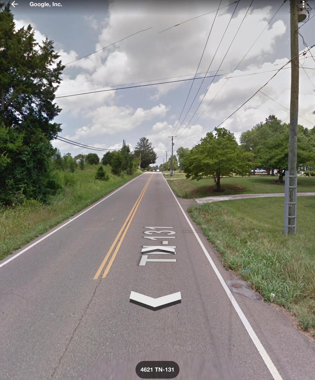
1 Betty Jo Mahan [MPC Comment] MPC File No. 6-G-18-RZ 1 message 'Myra Sharp' via Commission <commission@knoxmpc.org> We Reply-To: msharp6182@yahoo.com To: commission@knoxmpc.org In reference to: Agenda Item No. 40 Smithbilt LLC East side Willow Fork Ln., north side E. Emory Rd., Commission District 7. Rezoning from A (Agricultural to PR (Planned Residential). My name is Myra Sharp and my family lives at 4607 East Emory Rd in the Halls Crossroads community. I oppose the zoning changes for the following reasons: Increased traffic on East Emory Rd current traffic counts at the intersection of East Emory Rd/Willow Fork Ln are 12;299 vehicles per day. This section of East Emory Rd. is a 2 lane road, and the proposed subdivision entrance would be near a blind hill an speed limit is currently 45 mph, while the 5 lane section of East Emory Rd. between Norris Freeway and I-75 has a speed limit of 40. This section where the proposed subdivision would be located has no sidewalks and the ditch is so deep In some areas it pedestrians. As you can imagine, drivers speed on this section and the increased traffic will likely increase the number of accidents. Per Smithbilt the added daily traffic would be 321 more trips per day. Our section of East Emory currently has more traffic than the 5 lane portion of Norris Freeway between Maynardville Hwy & East Emory at the entrance to a large shopping center ( Rural Badcock s Furniture). The current daily traffic count there is 12,231. Our driveway is accessed via Willow Fork Ln and we are the only residents that use this 1 lane street. Traffic is so heavy and dangerous on East Emory that our mailbox is located on Willo We are also concerned about the impact to Willow Fork creek located to the north of the proposed subdivision. This creek borders our property on the north and west boundaries. This creek regularly overflows and our low lying property has experienced flo Halls Public Library was constructed in the 4500 block of East Emory. The 5.7 acres that Smithbilt owns is located directly to the east of our property and is elevated more than ours. We are concerned about the runoff and the impact it may have on our property. My husband s family has been on the 9 acres that we own for a long time. Actually his grandparents Clarence & Fannie (Silvey) Summey lived there from at least 1935 until they both passed away approximately 13 years ago. My father-in-law and mother-in-law built a house on this same property in My husband, two children and myself have lived in this home for 18 years. This is a special place to all of us and we have enjoyed living there. We have deer on our property y birds, owls, box turtles and an occasional red fox. We worry that the construction of 28 homes in the small area next door will have a negative impact on the wildlife native to this area. We enjoy watching the animals while we relax in our yard. We respectfully ask that you consider our concerns and questions while deciding this important matter. This will certainly negatively impact the traffic situation as the road widening process hasn t even began yet East Emory Between Maynardville Hwy and Tazewell Pk. We re concerned with the potential flooding to Willow Fork creek and our property that is downhill from the subdivision. What are the plans for the retention/detention pond. What kind of border/barrier will be installed between our property and 28 new homes? Like everyone else we enjoy returning home each day to a quiet, peaceful place when we get off work. We enjoy our time outside on the weekends as well. We are concerned about the noise level and fear that our peaceful area of Halls Crossroads will for negative way. Unfortunately we have not been contacted by anyone from Smithbilt and would just like to be made aware of their plans. Due to the traffic situation, noise level, concern for damage to our home and/or property due to water runoff, we respectfully request the rezoning be reduced to 3 homes per acre instead of 5 homes per acre. I have included pictures of the intersection of East Emory Rd and Willow Fork Ln.
2
3
4
5
6
7
8 Regards, Myra and Jeffrey Sharp 4607 East Emory Rd Knoxville TN This message was directed to
AGENDA REPORT. Issue: Discussion of potential improvements on Barnwell Road at Niblick Drive
 AGENDA REPORT To: From: By: Honorable Mayor and City Council Members Warren Hutmacher, City Manager Tom Black, Public Works Director Date: March 23, 2016 Agenda: March 28, 2016 WORK SESSION AGENDA: Barnwell
Lesson #7. Review: Lesson #6 Destination: Eureka. SKILLS A. Protected Left Turns
 SKILLS A. Protected Left Turns Lesson #7 Review: Lesson #6 Destination: Eureka 1. The only time you are protected from oncoming traffic is when you have a green left turn arrow 2. Oncoming traffic has
Swamp Road Residents Study
 Swamp Road Residents Study SRRG Meeting with PennDot and Elected Officials Newtown and Wrightstown, PA April 25, 2008 Newtown Township Section of Swamp Road Limited Public Funds No reconstruction of a
Personal History. Sharon McKenna s association with Little Lake Wilson began because of her parents desire to live closer to her.
 Oral history narrative from a joint program with Hillsborough County and the Florida Center for Community Design and Research Little Lake Wilson The following narrative is written based on an interview
SECTION 7 INVENTORY OF SELECTED INTERSECTIONS AND RECOMMENDATIONS FOR FURTHER STUDY
 SECTION 7 INVEY OF SELECTED INTERSECTIONS AND RECOMMENDATIONS FOR FURTHER STUDY The study corridor includes a total of 19 signalized intersections. Through consultation with Campbell County and the KYTC,
CURRENT ORIGINAL REFERENCE SECTIONS. (Typical Section) (Typical Section) The Parade Island Bay : Concept Option Summary Sheets.
 (Typical Section) The Parade Island Bay : Concept Option Summary Sheets.") ORIGINAL (Typical Section) CURRENT (Typical Section) 3,900 3,000 2,000 1,500 3,100 1,600 3,100 1,500 2,000 2,500 3,900 3,000 1,800 600 2,000 3,000 3,000 2,000 600 1,800 2,500 Existing Planting Traffic
ORIGINAL (Typical Section) CURRENT (Typical Section) 3,900 3,000 2,000 1,500 3,100 1,600 3,100 1,500 2,000 2,500 3,900 3,000 1,800 600 2,000 3,000 3,000 2,000 600 1,800 2,500 Existing Planting Traffic
Recommended Roadway Plan Section 2 - Land Development and Roadway Access
 Recommended Roadway Plan Section 2 - Land Development and Roadway Access SECTION 2 Land Development and Roadway Access 2.1 Land Use and Access Management The Federal Highway Administration (FHWA) defines
Lesson #13. Review: Lesson #12 Destination: Washington (Business and Residential)
") Lesson #13 Review: Lesson #12 Destination: Washington (Business and Residential) SKILLS A. Parallel parking (Not on final driver s test) 1. Signal leaving roadway 2. Pull parallel to vehicle you are going
Lesson #13 Review: Lesson #12 Destination: Washington (Business and Residential) SKILLS A. Parallel parking (Not on final driver s test) 1. Signal leaving roadway 2. Pull parallel to vehicle you are going
Homework Module 7.01 Drivers Manual Study Questions
 Homework Module 7.01 Drivers Manual Study Questions Name: Date: Directions: Use the Oregon Driver Manual to answer each of the following questions. It is suggested that you underline or highlight each
Boone County Commission Minutes 30 March March Session of the January Adjourned Term
 TERM OF COMMISSION: PLACE OF MEETING: PRESENT WERE: March Session of the January Adjourned Term Roger B. Wilson Boone County Government Center Commission Chambers Presiding Commissioner Keith Schnarre
Bank Street Widening Class EA Study Leitrim Road to Rideau Road. Gloucester South Seniors Centre, 4550 Bank Street
 AECOM 302 1150 Morrison Drive 613 820 8282 tel Ottawa, ON, Canada K2H 8S9 613 820 8338 fax www.aecom.com Minutes of Meeting Date of Meeting April 4, 2013 Start Time 6:30 p.m. Project Number 60246226 Project
Summary of data on crashes in unincorporated Knox County involving pedestrians and bicyclists
 Summary of data on crashes in unincorporated Knox County involving pedestrians and bicyclists Total numbers There were 5 crashes involving either pedestrians or bicyclists. 44 crashes involved pedestrians,
City of Sammamish. Welcome. Issaquah-Fall City Road Improvements Project Phase I Design: 242nd Avenue SE to Klahanie Drive SE
 Welcome Welcome to the third community meeting for the Issaquah-Fall City Road Improvements Project. AGENDA 6:00 p.m. Welcome and sign-in 6:10 p.m. Presentation 6:50 p.m. Open house Learn about the roadway
APPENDIX G: INTERSECTION NEEDS AT OKEECHOBEE BOULEVARD
 APPENDIX G: INTERSECTION NEEDS AT OKEECHOBEE BOULEVARD INTERSECTION NEEDS AT SR 7 and OKEECHOBEE BOULEVARD SR 7 Extension Project Development and Environment (PD&E) Study From Okeechobee Boulevard (SR
URBANA TRAFFIC COMMISSION Tuesday, November 12, 2013
 URBANA TRAFFIC COMMISSION Tuesday, November 12, 2013 MEMBERS PRESENT: Michael Madigan, City Council Member, Ward 6, Chair Joe Smith, Senior Civil Engineer Pat Connolly, Police Chief MEMBERS ABSENT: None
Los Altos Hills Town Council - June 18, 2015 Palo Alto City Council June 22, AGENDA ITEM #2.B Presentation
 Los Altos Hills Town Council - June 18, 2015 Palo Alto City Council June 22, 2015 AGENDA ITEM #2.B Presentation Previous Presentations Los Altos Hills Town Council in May 2014 and February 2015 Palo Alto
Subject: Bike Project Field Trial Must Validate Bike Safety Claims
 April 12, 2017 To: Menlo Park City Council Subject: Bike Project Field Trial Must Validate Bike Safety Claims A few weeks ago, a collision between my road bike and a white pick-up truck on Woodside Road
WELCOME!! WAIMEA REGIONAL SAFETY STUDY COMMUNITY MEETING PEL 2 DECEMBER 5, 2018 WAIMEA ELEMENTARY SCHOOL
 WELCOME!! WAIMEA REGIONAL SAFETY STUDY COMMUNITY MEETING PEL 2 DECEMBER 5, 2018 WAIMEA ELEMENTARY SCHOOL TONIGHT S AGENDA Welcome and Introductions Recap PEL 1 Meeting: What is this study? What are the
Overview. Project No Ryan Cutler Ada County Highway District Christy Foltz-Ahlrichs Ada County Highway District. Heidi Carter, P.E.
 Project No. 511031.001 To: From: Ryan Cutler Ada County Highway District Christy Foltz-Ahlrichs Ada County Highway District Heidi Carter, P.E. Date: June 22, 2015 Subject: May 13, 2015 Public Involvement
Roadway Classification Design Standards and Policies. Pueblo, Colorado November, 2004
 Roadway Classification Design Standards and Policies Pueblo, Colorado November, 2004 Table of Contents Page Chapter 1. General Provisions 1.1 Jurisdiction 3 1.2 Purpose and Intent 3 1.3 Modification 3
Shared Autonomous Vehicle Street Design Lexington & Marshall
 Getting Ready for Shared Autonomous Vehicles Fleets of shared autonomous vehicles (SAV s) will be on our roads within a decade as part of mobility services offered by both car and technology companies,
February 2018 HIGHWAY 316 IMPROVEMENTS PROJECT
 February 2018 HIGHWAY 316 IMPROVEMENTS PROJECT Agenda 1 2 3 4 5 A Message from the City Project Area Traffic Conditions Pedestrian/Bicycle Comfort & Safety Next Steps Q&A City of Hastings Supports a study
Rabbit Creek Community Council
 Rabbit Creek Community Council P.O. Box 112354, Anchorage, AK 99511-2354 Page 1 To: Troy Swanson, Office of the Mayor Christine Chesnut, OMB Budget Analyst Gary Jones, Public Works Dear Staff, May 31,
GEOMETRIC DESIGN STANDARDS FOR NEW RESIDENTIAL SUBDIVISION STREETS TABLE 1A CG-6 CURB AND GUTTER SECTION
 TABLE 1A CG-6 CURB AND GUTTER SECTION HORIZONTAL AND VERTICAL CONTROLS CURB AND GUTTER ROADWAYS MAXIMUM 3:1 CUT OR FILL SLOPE CURVE DATA MIN. SIGHT DISTANCE PROJECTED TRAFFIC VOLUME (ADT) MIN. DESIGN SPEED
DEPARTMENT OF COMMUNITY PLANNING, HOUSING AND DEVELOPMENT Planning Division/Site Plan Review Committee
 DEPARTMENT OF COMMUNITY PLANNING, HOUSING AND DEVELOPMENT Planning Division/Site Plan Review Committee 2100 Clarendon Boulevard, Suite 700, Arlington, VA 22201 TEL 703-228-3525 FAX 703-228-3543 www.arlingtonva.us
Caltrans Sloat Boulevard Pedestrian Safety Project Response to Community Questions, Comments & Concerns
 Caltrans Sloat Boulevard Pedestrian Safety Project Response to Community Questions, Comments & Concerns Revised: May 10, 2016 The California Department of Transportation (Caltrans) is planning various
Public Information Centre
 WELCOME Public Information Centre Father Tobin Road Lougheed Middle School - Library Wednesday November 7, 2012 7:00 p.m.to 9:00 p.m. Please sign in Neighbourhood Traffic Calming Guide Background The City
Appendix A. Knoxville TPO Greenway Signage Guidelines. Appendix A: Knoxville TPO Greenway Signage Guidelines Knox to Oak Ridge Greenway Master Plan
 Appendix A Knoxville TPO Greenway Signage Guidelines 75 Overview: Adequate signing and marking are essential on shared-use paths, especially to alert bicyclists to potential conflicts and to convey regulatory
Attachment No. 13. National Committee on Uniform Traffic Control Devices RWSTC RECOMMENDATION FOLLOWING SPONSOR COMMENTS
 1 2 3 4 Attachment No. 13 5 6 7 8 9 10 11 12 13 14 15 16 17 18 19 20 21 22 23 24 25 26 27 28 29 30 31 32 33 34 35 36 37 38 39 40 41 42 43 RWSTC agenda item IV. 2 June 2011 National Committee on Uniform
ACHD Board of Commissioners Stacey Yarrington, Planner III Tandem Ridge/ EPP / PP-07-16/ RZ-12-16/ CPA-01-16/ A-07-16
 Development Services Department DATE: December 14, 2016 TO: FROM: SUBJECT: ACHD Board of Commissioners Stacey Yarrington, Planner III Tandem Ridge/ EPP16-0012/ PP-07-16/ Executive Summary: This is an annexation,
5 CIRCULATION AND STREET DESIGN
 5 CIRCULATION AND STREET DESIGN This chapter describes circulation and streetscape improvements proposed for the Northwest Chico Specific Plan Area. It includes detailed design specifications for existing
TRAFFIC CALMING TOOLBOX. For the residents of the City of Decatur, Georgia
 TRAFFIC CALMING TOOLBOX For the residents of the City of Decatur, Georgia 2 City of Decatur Traffic Calming Toolbox Public Works Department 2635 Talley Street Decatur, GA 30030 404.377.5571 3 Welcome to
a. Paint your vehicle a different color b. Install a new muffler c. Sell or transfer your vehicle
 Reference: If you do not know the answer, refer to: Note: CDH stands for the California Driver Handbook Final Exam No. 1 1. You must notify DMV within 5 days if you: Question 1. CDH page 89 a. Paint your
Transportation Advisory Board
 C I T Y O F WEATHERFORD Transportation Advisory Board AGENDA REPORT Meeting Date: October 15,2015 Staff Contact: Manny Palacios Jr. Phone: E-mail: 817-598-4296 mpalacios@weatherfordtx.gov SUBJECT: Discuss
BOARD OF COUNTY COMMISSIONERS CLAY COUNTY
 - 1 - BOARD OF COUNTY COMMISSIONERS Stephanie C. Kopelousos County Manager And Clerk of the Board www.claycountygov.com CLAY COUNTY Public Works Traffic Control Division 5 Esplanade Ave. Green Cove Springs,
SAFE ROUTES TO SCHOOL
 SAFE ROUTES TO SCHOOL Forest Ridge Elementary School Existing Conditions and ACTION PLAN > Oak Creek - Franklin Joint School District Table of Contents CONTEXT Enrollment Boundaries
Purple Line Extension Community Meeting
 Purple Line Extension Community Meeting August 22, 2016 Agenda Introductions Meeting Goals Project Overview and Schedules Proposed Memorandum of Agreement Overview Stay in Touch! Q & A Meeting Goals Provide
For sale 20 ACRE PASTURE/HOME SITE
 For sale 20 ACRE PASTURE/HOME SITE Indiantown, fl 3500 SW CORPORATE PKWY, SUITE 202 PALM CITY, FL 34990 772 287-4690 - 772 287-9643 (Fax) PROPERTY INFORMATION LOCATION: SW Fox Brown Road Indiantown, FL
Midway City Council 15 January 2019 Regular Meeting. Homestead Villas / Preliminary Approval
 Midway City Council 15 January 2019 Regular Meeting Homestead Villas / Preliminary Approval CITY COUNCIL MEETING STAFF REPORT DATE OF MEETING: January 15, 2018 NAME OF PROJECT: NAME OF APPLICANT: AGENDA
SEWARD MERIDIAN PARKWAY IMPROVEMENTS, PHASE II Palmer-Wasilla Highway to Seldon Road Project Number Z / EVENT NOTES
 SUBJECT: SEWARD MERIDIAN PARKWAY IMPROVEMENTS, PHASE II Palmer-Wasilla Highway to Seldon Road Project Number Z512210000/0001417 EVENT NOTES Seward Meridian, Phase II PROJECT NUMBER: Z512210000/0001417
12/13/2018 VIA
 12/13/2018 VIA EMAIL Daniel Abbes, Assistant Planner City of Sacramento community Development Department 300 Richards Blvd., 3 rd Floor Sacramento, CA 95811 RE: Bruceville Apartments (P18-073) Dear Mr.
Report. Typical Sections. City of Middleton, WI
 Report Typical Sections City of Middleton, WI December 2006 Report for City of Middleton, Wisconsin Typical Sections repared by: Traffic Associates LLC and STRAND ASSOCIATES, INC. 910 West Wingra Drive
Corpus Christi Metropolitan Transportation Plan Fiscal Year Introduction:
 Introduction: The Safe, Accountable, Flexible, Efficient Transportation Equity Act: A Legacy for Users (SAFETEA-LU) has continued the efforts started through the Intermodal Surface Transportation Efficiency
Student Pedestrian Safety Fiddlers Canyon Elementary Community Council 2012
 Student Pedestrian Safety Fiddlers Canyon Elementary Community Council 2012 Introduction Fiddlers Canyon Elementary students must cross North Wedgewood Lane and Fiddlers Canyon Drive in order to come to
Coachman Ridge Neighborhood Plan. Neighborhood Strengths and Weaknesses
 Coachman Ridge Neighborhood Plan Neighborhood Strengths and Weaknesses At the first public neighborhood meeting held by the study committee on March 22, 2001, participants divided up into three groups
Access requests to County streets and roadways are processed through one of the following methods:
 13.1 GENERAL APPLICATION PROCESS Access requests to County streets and roadways are processed through one of the following methods: A. Planned Developments may set general locations for access points.
Description of Road Management Objectives, Existing Use, and Proposed Use:
 Engineering Report White River National Forest Eagle-Holy Cross Ranger District Analysis of Road # 700 Red Sandstone Road for Motorized Mixed Use Designation Page 1 of 12 Forest: White River District:
SAFE ROUTES TO SCHOOL
 SAFE ROUTES TO SCHOOL Edgewood Elementary School Existing Conditions and ACTION PLAN > Oak Creek - Franklin Joint School District Table of Contents CONTEXT Enrollment Boundaries Enrollment
2015 Data review. Capturing Ready Lane NEXUS vehicles
 2015 Data review Capturing Ready Lane NEXUS vehicles Problem: NEXUS users make up the majority of traffic using the Ready Lane, but they are currently considered either standard traffic or Ready Lane traffic.
MEET IN THE STREET MOVING TO ZERO
 WE MEET IN THE STREET MOVING TO ZERO Tips for sharing the street Traffic deaths are preventable. We need your help getting the message out. 2 A NEW PLAN A NEW PLAN Philadelphia is proud to adopt Vision
Corporate. Report COUNCIL DATE: May 25, 1998 NO: R1500 REGULAR COUNCIL. TO: Mayor & Council DATE: April 27, 1998
 R1500 : Traffic Safety at 25 Avenue and 128 Street Intersection Corporate NO: R1500 Report COUNCIL DATE: May 25, 1998 REGULAR COUNCIL TO: Mayor & Council DATE: April 27, 1998 FROM: General Manager, Engineering
Gornto Lake Narrative
 Gornto Lake Narrative The following narrative is based on an interview with Roy Schiro at his home on Gornto Lake on July 26, 2001. Roy has a very deep heritage with the lake and the surrounding area.
APPENDIX B1. CROSS-REFERENCE GUIDE TO THE OHIO REVISED CODE
 Appendix B1. Cross-Reference Guide to the Ohio Revised Code Page B1-1 APPENDIX B1. CROSS-REFERENCE GUIDE TO THE OHIO REVISED CODE The Ohio Revised Code (O.R.C.) contains many laws which apply to the control
Controlled. Semi-Controlled PAGE 01 CHAPTER 12 INTERSECTIONS
 PAGE 01 CHAPTER 12 INTERSECTIONS You will cross many intersections while driving. Intersections are especially dangerous because vehicles are crossing each other s driving path. Many crashes happen at
Chapter 5 FUNCTIONAL CLASSIFICATION
 Chapter 5 FUNCTIONAL CLASSIFICATION Functional classification is a system by which streets and roadways may be distinguished by types according to their function within the entire transportation network.
Bicycle and Pedestrian Advisory Committee (BPAC) November 21, 2013
 November 21, 2013") Bicycle and Pedestrian Advisory Committee (BPAC) November 21, 2013 OVERALL LAND USE CONCEPT Overall Broadway Valdez District: 95.5 acres (35.1 acres right-of ways + 60.4 acres developable land) Plan Subareas:
Bicycle and Pedestrian Advisory Committee (BPAC) November 21, 2013 OVERALL LAND USE CONCEPT Overall Broadway Valdez District: 95.5 acres (35.1 acres right-of ways + 60.4 acres developable land) Plan Subareas:
Unit Five : Driving In Neighborhoods
 Unit Five : Driving In Neighborhoods What Are We Going To Do Today? Students will be able to describe the skills necessary to How safely and do legally you make drive in a residential How do area. you
ROAD OCCUPANCY PERMIT APPLICATION # Damascus Township, 60 Conklin Hill Road, Damascus, PA Tel Fax
 Instructions: For a driveway access permit, fill in sections 1, 2, 3 and 4, and the appropriate drawings and sign. For a Utility access, fill in sections 1, 2, 3 and 5, and figures 1 and 3. Prepare a detailed
Development Services Department
 Kent Goldthorpe, President Paul Woods, Vice President Rebecca W. Arnold, Commissioner Sara M. Baker, Commissioner Jim D. Hansen, Commissioner July 28, 2016 Development Services Department To: From: ACHD
Peer Review of Highlands Neighborhood Traffic and Pedestrian Safety Plan
 FINAL REPORT March 14, 2017 Prepared for: Ada County Highway District Prepared by: SIX MILE ENGINEERING, PA Executive Summary The (Highlands Safety Plan) developed by the Ada County Highway District (ACHD)
Welcome to the Public Meeting. Red Hill Business Park South Transportation Master Plan Addendum. December 4, :00 p.m. to 8:00 p.m.
 Welcome Welcome to the Transportation Master Plan Addendum December 4, 2012 6:00 p.m. to 8:00 p.m. Please sign-in Background PIC#1 Public Information Centre #1 (PIC#1) was held on June 25, 2012. Feedback
HILLSIDE DISTRICT PLAN White Paper
 HILLSIDE DISTRICT PLAN White Paper ROADWAY CLASSIFICATION July 31, 2007 REPORT CONTENTS Overview p.1 Existing Context & Regulatory Framework p.1 Roadway Classification p.3 Street Typology Additions to
City of Albert Lea Policy and Procedure Manual 4.10 ALBERT LEA CROSSWALK POLICY
 4.10 ALBERT LEA CROSSWALK POLICY PURPOSE: Pedestrian crosswalks are an integral part of our transportation infrastructure. To be effective and promote safety, marked crosswalks must be installed after
M I N U T E S OKLAHOMA COUNTY PLANNING COMMISSION
 M I N U T E S OKLAHOMA COUNTY PLANNING COMMISSION September 21, 2000 1:30 P.M. The meeting of the Oklahoma County Planning Commission convened and was called to order by Ms. Cheryl Dorrance, at 1:30 P.M.,
Napa County Planning Commission Board Agenda Letter
 Agenda Date: 8/17/2016 Agenda Placement: 9D Napa County Planning Commission Board Agenda Letter TO: FROM: Napa County Planning Commission John McDowell for David Morrison - Director Planning, Building
Traffic Signs and Signals
 CHAPTER FOUR Traffic Signs and Signals Traffic signs control traffic flow, making streets and highways safer for drivers, bicyclists and pedestrians. These signs, which are posted by the Indiana Department
A G E N D A OKLAHOMA COUNTY PLANNING COMMISSION. November 16, Approval of Minutes of the Previous Meeting: (October 19, 2006)
") A G E N D A OKLAHOMA COUNTY PLANNING COMMISSION ROOM 103 1:30 p.m. November 16, 2006 1. Notice of meeting posted November 9, 2006. 2. Call to Order. 3. Roll Call. 4. Approval of Minutes of the Previous
A G E N D A OKLAHOMA COUNTY PLANNING COMMISSION ROOM 103 1:30 p.m. November 16, 2006 1. Notice of meeting posted November 9, 2006. 2. Call to Order. 3. Roll Call. 4. Approval of Minutes of the Previous
12/4/2016 VIA . RE: Grocery Outlet Del Paso (DR16-328)
") 12/4/2016 VIA EMAIL Ethan Meltzer, Assistant Planner City of Sacramento Community Development Department 300 Richards Blvd, 3 rd Floor Sacramento, CA 95811 RE: Grocery Outlet Del Paso (DR16-328) Dear Mr.
12/4/2016 VIA EMAIL Ethan Meltzer, Assistant Planner City of Sacramento Community Development Department 300 Richards Blvd, 3 rd Floor Sacramento, CA 95811 RE: Grocery Outlet Del Paso (DR16-328) Dear Mr.
4.11 TRANSPORTATION/CIRCULATION
 4.11 TRANSPORTATION/CIRCULATION This section was developed using information from a Traffic Analysis Report prepared for the project by OEG, Inc. (2010), the Paradiso del Mare Ocean and Inland Estates
Lawrence Loop SWOT Analysis
 Alignment: A1 (Map Color: Red) Description: This alignment connects to the Sandra Shaw Trail on the north side of the pond and heads north through undeveloped property and then west to Michigan Street
RIVERSIDE, Newton MA BH NORMANDY RIVERSIDE LLC. Riverside Station. A green, transit-oriented community
 Riverside Station A green, transit-oriented community October 6, 2011 TONIGHT S AGENDA: 1. Project Update (5 min.) 2. Master Plan Update (10 min.) 3.Traffic Plan Update (10 min.) Questions & Answers MASTER
NEW BUSINESS CITY PLANNING COMMISSION AGENDA ITEM NO: 4 STAFF: STEVE TUCK FILE NO: CPC UV QUASI-JUDICIAL
 Page 47 NEW BUSINESS CITY PLANNING COMMISSION AGENDA ITEM NO: 4 STAFF: STEVE TUCK FILE NO: CPC UV 08-00154 QUASI-JUDICIAL PROJECT: APPLICANT: OWNER: GENERAL OR MEDICAL OFFICE AT 1730 NORTH CORONA STREET
Urban Planning and Land Use
 Urban Planning and Land Use 701 North 7 th Street, Room 423 Phone: (913) 573-5750 Kansas City, Kansas 66101 Fax: (913) 573-5796 Email: planninginfo@wycokck.org www.wycokck.org/planning To: From: City Planning
US287 Asset Inventory Fort Collins. Figure 5-1 Fort Collins Bridges and Traffic Signals
 Chapter 5: City of Fort Collins US287 through Fort Collins is known as College Avenue, runs for approximately 9.25 miles, and bisects the City north to south. Within the City, US287 is a principal arterial.
Speed Control & Limits
 Speed Control & Limits Exceeding the speed limit is a common contributing factor of fatal and other types of accidents. *25 mph* School zones, business or residential districts *55 mph* Certain state highways
State Highway 16 Kuna-Mora Road to Ada/Gem County Line
 Background State Highway 16 is the main commuter route from Gem County to the Treasure Valley. An increase in traffic and accidents on this highway have been a concern for several years, and the Idaho
STAFF REPORT TO THE PLANNING COMMISSION December 12,2016. Schuler Shoes PUD Concept and Development Stage Plan And Rezoning
 STAFF REPORT TO THE PLANNING COMMISSION December 12,2016 PUD Concept and Development Stage Plan And Rezoning Applicant: Owner: Requested Action: Location: Zoning: Edward Farr Architects Brad Neuerburg
State Highway 16/McDermott Road Kuna-Mora Road to Ada/Gem County Line
 Background State Highway 16 is the main commuter route from Gem County to the Treasure Valley. An increase in traffic and accidents on this highway have been a concern for several years, and the Idaho
Roundabouts and Access Management
 Roundabouts and Access Management ABSTRACT This paper discusses the implementation of a series of four roundabouts on a suburban arterial serving a strip commercial area. The project is located on South
GENERAL CODE PROVISIONS TABLE OF CONTENTS
 GENERAL CODE PROVISIONS CHAPTER 1 CODE OF ORDINANCES... 1 CHAPTER 2 CHARTER... 9 CHAPTER 3 BOUNDARIES... 11 CHAPTER 4 MUNICIPAL INFRACTIONS... 17 CHAPTER 5 OPERATING PROCEDURES... 25 CHAPTER 6 CITY ELECTIONS...
Chapter 6 Performing Basic Vehicle Maneuvers
 Chapter 6 Performing Basic Vehicle Maneuvers Correct hand position To turn use Hand over hand steering Push and Pull steering Steering Turn Signals Use indicators/signals Indicators inform other drivers
Complete Streets. Designing Streets for Everyone. Sarnia
 Complete Streets Designing Streets for Everyone Sarnia Complete Streets ~ Sarnia ~ 2018 Introduction Our City is made up of a network of streets that we use to go for a walk, cycle to work, drive to the
State Highway 16 Kuna-Mora Road to Ada/Gem County Line
 Background Update! (February 2018): This project has been partially funded; see below. State Highway 16 is the main commuter route from Gem County to the Treasure Valley. An increase in traffic and accidents
Improve the livability of our streets by
 Pedestrian and Traffic Calming Policy March 2018 2 of 6 Neighborhood Traffic Calming Policy The City of Aspen continually strives to protect multimodal function while maintaining a high standard of safety.
MEMORANDUM TERESA MCCLISH, COMMUNITY DEVELOPMENT DIRECTOR SUBJECT: CONSIDERATION OF RESTRICTING PARKING ADJACENT TO 170 AND 171 BRISCO ROAD
 MEMORANDUM TO: FROM: BY: TRAFFIC COMMISSION TERESA MCCLISH, COMMUNITY DEVELOPMENT DIRECTOR MATT HORN, CITY ENGINEER SUBJECT: CONSIDERATION OF RESTRICTING PARKING ADJACENT TO 170 AND 171 BRISCO ROAD DATE:
To: ACHD Commissioners and Director 3/14/2017. Peer Review of Highlands Neighborhood Traffic and Pedestrian Safety Plan Information Briefing
 Paul Woods, President Rebecca W. Arnold, Vice President Kent Goldthorpe, Commissioner Sara M. Baker, Commissioner Jim D. Hansen, Commissioner MEMORANDUM Engineering To: ACHD Commissioners and Director
STATE OF VERMONT ENVIRONMENTAL COURT } } } } } Decision and Order
 STATE OF VERMONT ENVIRONMENTAL COURT In re: Appeal of Ted S. Gladstone and Kathleen Hoisington Docket No. 190-10-99 Vtec Decision and Order Appellants appealed from a decision of the Planning Commission
Reams Road RCA Study. Board of County Commissioners Public Hearing
 Reams Road RCA Study Board of County Commissioners Public Hearing April 24, 2018 Presentation Overview Study Overview Existing Conditions Development of Alternatives Preferred Alternative Public Involvement
5 Transit & Traffic. Overview
 5 Transit & Traffic Overview Montgomery Place s roadways and overall traffic circulation are unique in the city due to the narrow streets and avenues with boulevards; however, no sidewalks or curbs in
SETTINGS AND OPPORTUNITIES MOBILITY & ACCESS
 7 mobility & access how do people use el camino what is it like to drive on el camino/to park along el camino what is the pedestrian experience like what is the role of transit along the corridor what
San Rafael School District. Task Force Meeting Notes. November 5, 2012
 San Rafael School District Task Force Meeting Notes November 5, 2012 Attendees (8) Wendi Kallins Program Director for Safe Routes to Schools; Laura Kelly Volunteer Liaison for Safe Routes to Schools; Leslie
Water Street Promenade Engineering and Design Services
 Preliminary Design Presentation Parking & Traffic Safety Committee Water Street Promenade Engineering and Design Services July 16,2014 November 3, 2016 Education / Infrastructure / Innovation 1 Project
Driveway Design Criteria
 Design Manual Chapter 5 - Roadway Design 5L - Access Management 5L-4 Driveway Design Criteria A. General For efficient and safe operations, access drives and minor public street intersections can be improved
Driver Education Ch. 4: Safe Driving Rules & Regulations. Ms. Marx
 Driver Education Ch. 4: Safe Driving Rules & Regulations Ms. Marx Speed Control Speed is one of the most common contributing factors of fatal & other types of accidents School zones, business or residential
APPENDIX L. Design Criteria
 APPENDIX L Design Criteria DRAFT PRELIMINARY DESIGN CRITERIA Page 1 of 18 APPROVALS MANAGER, ENGINEERING CITY OF HAMILTON MANAGER, ENGINEERING REGION OF HALTON DATE This Design Criteria for the New East-West
HIGHBURY AVENUE/HAMILTON ROAD INTERSECTION IMPROVEMENTS PUBLIC INFORMATION CENTRE 1 MAY 14, 2015
 HIGHBURY AVENUE/HAMILTON ROAD INTERSECTION IMPROVEMENTS Municipal Class Environmental Assessment PUBLIC INFORMATION CENTRE 1 MAY 14, 2015 ACCESSIBILITY Under the Accessibility Standards 2015 for Customer
3.0 PROJECT DESCRIPTION
 The following section of the Draft EIR contains a description of the proposed Elk Grove Boulevard/SR 99 Interchange Modification project, consistent with the requirements of CEQA Guidelines Section 15124.
TRAFFIC CALMING GUIDE FOR TORONTO CITY OF TORONTO TRANSPORTATION SERVICES DIVISION
 TRAFFIC CALMING GUIDE FOR TORONTO CITY OF TORONTO TRANSPORTATION SERVICES DIVISION CITY OF TORONTO TRANSPORTATION SERVICES DIVISION 2016 TRAFFIC CALMING GUIDE FOR TORONTO TABLE OF CONTENTS Introduction
Drivers Responsibilities to Pedestrians
 Drivers Responsibilities to Pedestrians The following 60 slides use real photos, a video clip and quizzes to teach drivers what to do when they encounter a pedestrian. This takes about 5 minutes to view.
February 26, 2013 Presentation Overview of Proposed Roadway Network and Intersection Improvements Bond Program
 February 26, 2013 Presentation Overview of Proposed Roadway Network and Intersection Improvements Bond Program Excellence - Integrity - Service - Creativity - Communication TRANSPORTATION BOND PROGRAM