CITY OF DELAFIELD (262) Public Works Committee Meeting Agenda Wednesday, August 2, :30 p.m.
|
|
|
- Valentine Simmons
- 5 years ago
- Views:
Transcription
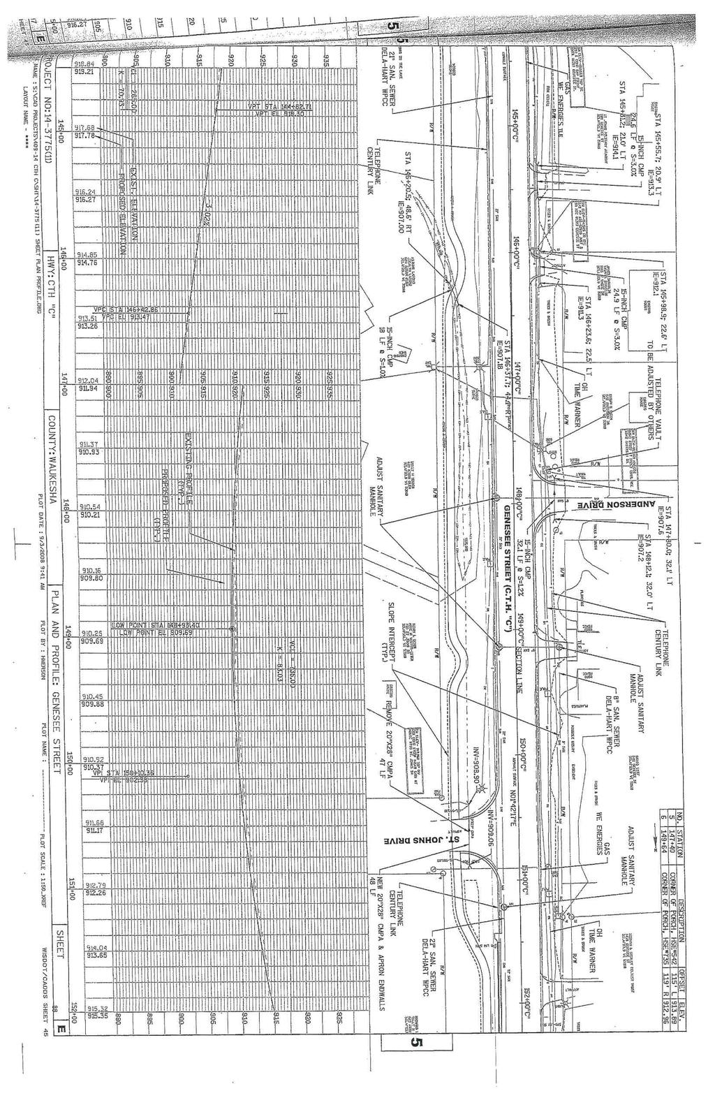
1 Call Public Works Committee Meeting to Order. Pledge of Allegiance. Roll Call. 1. Approve minutes of June 7, CITY OF DELAFIELD (262) Public Works Committee Meeting Agenda Wednesday, August 2, :30 p.m. **CITY HALL COMMON COUNCIL CHAMBERS** 500 Genesee Street, Delafield, WI City of Delafield Citizen's Comments for items on the agenda. 3. Unfinished Business. a. Discussion and action regarding request from Common Council for recommendation on adding crosswalks across CTH C at the intersections north of the Bark River Bridge. 4. New Business. a. Discussion and action regarding request from resident to consider no parking along Price Road. 5. Reports - Director of Public Works/City Engineer/Traffic Staff a. Director of Public Works b. City Engineer. 1. Update on 2017 Street Improvement Program. 2. Update on DPW Cold Storage Building Project. c. Traffic Staff. 6. Correspondence. 7. Adjourn. Person requiring an interpreter or other assistance should contact the City Clerk s office (262) , 72 hours prior to the meeting. Notice is hereby given that a majority of the City Council or Plan Commission may be present at the meeting of the Public Works Committee meeting scheduled for August 2, 2017 to gather information about subject over which they have decision making responsibility. This constitutes a meeting of the City Council or Plan Commission pursuant to State ex rel. Badke v. Greendale Village Bd., 173 Wis. 2d 553, 494 N.W.2d 408 (1993), and must be noticed as such, although the Council and Plan Comm. will not take any formal action at this meeting. Utility Clerk SJ Posted: X City Hall Bulletin Board X Website X Faxed to Newspapers
2 Wednesday, June 7, 2017 Page 1 of 5 CITY OF DELAFIELD PUBLIC WORKS COMMITTEE MEETING MINUTES DRAFT 6:30 PM Call Public Works Committee Meeting to Order Jashinsky called the meeting to order at 6:30PM. Pledge of Allegiance The Pledge of Allegiance was recited. Roll Call for the Wednesday, June 7, 2017 Public Works Committee meeting: UPresentU UAbsent Dan Jashinsky, Chair Harold Roberts Art Baumann Jeremy Craven Mark Millot Dan Miller Jackie Valde, Ald Also present Mike Court, Engineer Tom Hafner, City Administrator/Director of Public Works 1. Approve minutes of March 1, 2017 Public Works Committee Meeting. There were no objections from the Public Works Committee; therefore, the March 1, 2017 Public Works Committee Meeting minutes were approved as presented. 2. City of Delafield Citizen's Comments Kent Attwell, 2816 Ridley Road, was present regarding Items 4c and 4f on the agenda. Regarding item 4c, He was in support of altering the speed limit on the new part of Highway C to make the transition of various speeds a bit easier for motorists. He questioned the need for a lower speed limit on portions of the roadway since the path was now separated from the roadway and houses were set back at a suitable distance. Regarding Item 4f, he noted that the City of Delafield 2030 Comprehensive Plan included a plan for paths in existing and new subdivisions and along main roadways. The plan also explained that any time a roadway was resurfaced; a separated path should be investigated for inclusion in the roadway resurfacing plans in certain areas. Specific roadways, including the recently completed portion of Highway C, portions of Milwaukee Street and Nagawicka Road, were noted as areas of interest within the plan. Hearing no objections, City of Delafield Citizen s Comments was closed. 3. Unfinished Business a. Lumber Inn use of right-of-way south of the sidewalk. Discussion and possible action regarding Lumber Inn s request to use a portion of the Wells Street right-of-way. Recommendations from the last Public Works Committee meeting had been shared with the owner of the Lumber Inn. The owner had proposed planting pots and benches to be placed atop poured concrete to provide a barrier area for seating south of the sidewalk. Discussion ensued regarding enforcement of ordinances, safety and right-of-way concerns related to the current situation. Concern was expressed regarding the location of the tables, chairs and areas where servers would need to walk outside the seating area that brought people closer to the
3 Wednesday, June 7, 2017 Page 2 of 5 CITY OF DELAFIELD PUBLIC WORKS COMMITTEE MEETING MINUTES DRAFT 6:30 PM 4. New Business travel lanes of the roadway. Discussion also took place regarding options available on the site. If the on-street parking were eliminated from the south side of the restaurant, there would need to be at least a two foot buffer from a curb to ensure that mirrors from passing cars were not close to the people eating at the tables. Parking in the area was a priority in the past. To add curb and gutter would remove the parking stalls. Safety for all remained a concern. BAUMANN MOVED TO RECOMMEND TO THE PLAN COMMISSION THAT TWO ALTERNATIVES BE CONSIDERED FOR RESOLUTION FOR LUMBER INN S REQUEST TO USE A PORTION OF THE WELLS STREET RIGHT-OF-WAY SOUTH OF THE EXISTING SIDEWALK, INCLUDING OPTION ONE TO CONVERT A NUMBER OF STALLS TO THE EASTERLY SIDE OF THE BUILDING TO EATING SPACE AND TO REMOVE ALL TABLES, CHAIRS AND IMPROVEMENTS IN THE RIGHT-OF-WAY SOUTH OF THE EXISTING CONCRETE WALKWAY OR OPTION TWO TO PROVIDE PLANS FOR INSTALLATION OF MINIMUM 30 INCH RAISED CURB, WITH REMOVAL OF ON-STREET PARKING, NO SEATING WITHIN TWO FEET OF THE FACE OF THE CURB OR FOUR FEET FROM THE TRAVEL LANE, NO CHAIRS WITHIN TWO FEET OF THE FACE OF THE CURB OR INSIDE THE CONCRETE SIDEWALK AREA. MILLOT SECONDED THE MOTION. THERE WAS NO FURTHER DISCUSSION. ALL WERE IN FAVOR. MOTION CARRIED. a. Discussion and action regarding the KB Real Estate site plan and storm water maintenance agreement for the new warehouse building located at 3655 Kettle Court East. The recommendation of the storm water maintenance agreement to be forwarded to the Common Council. Court noted the location of the proposed building for the Committee as well as a proposed storm water maintenance agreement included in the epacket for this meeting. Engineering comments and concerns had been addressed. Parking was included for future use; however, the site was not using the parking spaces currently. JASHINSKY MOVED TO APPROVE A STORM WATER MAINTENANCE AGREEMENT AS PRESENTED AT THIS MEETING FOR A NEW WAREHOUSE BUILDING LOCATED AT 3655 KETTLE COURT EAST AND TO RECOMMEND TO THE COMMON COUNCIL THE SAME. VALDE SECONDED THE MOTION. THERE WAS NO FURTHER DISCUSSION. ALL WERE IN FAVOR. MOTION CARRIED. b. Discussion and action regarding request from Common Council for recommendation on adding crosswalks across CTH C at the intersections north of the Bark River Bridge. Discussion ensued regarding the desired addition of a crosswalk north of the current crosswalk near the Post Office along Highway C. Various crosswalk locations north of Exeter Street were discussed as part of past CTH C Committee meetings. There were no paths to cross to on the easterly side of the hill coming south on Highway C. Topography made it difficult to consider placement of another path on the easterly side of the roadway. In order to place a crosswalk at the Oakwood intersection, necessary upgrades were required. Discussion ensued regarding the ability to conceptualize various crosswalk locations in order to better determine a potential cost for future planning. Engineering staff would provide conceptual drawings of potential crosswalk locations at the next Committee meeting.
4 Wednesday, June 7, 2017 Page 3 of 5 CITY OF DELAFIELD PUBLIC WORKS COMMITTEE MEETING MINUTES DRAFT 6:30 PM c. Discussion and action regarding request from Common Council for recommendation on reducing the speed limit on CTH C from Exeter Street to Oakwood Drive from 35 MPH to 25 MPH. Committee members discussed the varying speeds along Highway C from Exeter Street to Oakwood Drive. If a crosswalk were to be added in this area, speed limits would be reduced as a result. The City did not have jurisdiction of the roadway to set speed limits north of Oakwood Road. A speed study was suggested to provide data on crashes, roadway speeds and rural character of the roadway. More information would be available on this matter at the next Committee meeting. d. Discussion and action to set City policy regarding painted crosswalks and when/where to use traditional parallel lines or high-visibility crosswalk patterns such as a ladder, continental design or diagonal marking. Jashinsky noted Item 4d and 4e would be discussed concurrently. The pedestrian signing and pavement markings information provided in the epacket for this meeting was reviewed. There was no standard used in the City currently. Different types of existing pavement markings used in the City including ladder, continental, diagonal hatching and standard crosswalk markings were noted. Discussion took place regarding how to establish guidelines relative to the type of marking used at different crosswalk locations. Painting costs were reviewed with no significant additional cost noted for high visibility paint. Several examples of areas where high visibility paint might be desired were shared by various Committee members at this time, including the crossing near Wholly Cow!. Certain kinds of crosswalk markings, such as continental markings, might be more effective in certain situations, such as in a mid-block crossing situation or when used to mark a bike path. Continental markings could be added to existing crosswalks at the time of roadway resurfacing. County staff indicated. A shift toward ladder markings was noted by Waukesha County staff at county crosswalks. Existing crosswalk locations and types could be noted on a City map to enhance discussion at a future meeting. VALDE MOVED TO INCORPORATE LADDER MARKINGS IN THE CROSSWALK PAINT DESIGN AT MAIN STREET AND ONEIDA TO ENHANCE VISIBILITY AND UPON RESURFACING THE ROADWAY SHIFT THE CROSSWALK PATTERN MARKINGS TO THE CONTINENTAL PATTERN. MILLOT SECONDED THE MOTION. THERE WAS NO FURTHER DISCUSSION. ALL WERE IN FAVOR. MOTION CARRIED. At the request of Committee members, Jashinsky returned to this item after discussion of item 4c on the agenda. Committee members discussed using high visibility markings on all intersections instead of certain types of intersections throughout the City. JASHINSKY MOVED TO CONVERT ALL CROSSWALK PAVEMENT MARKINGS TO CONTINENTAL THROUGHOUT THE CITY AT THE TIME ROADWAYS WERE RESURFACED. VALDE SECONDED THE MOTION. THERE WAS NO FURTHER DISCUSSION. ALL WERE IN FAVOR. MOTION CARRIED.
5 Wednesday, June 7, 2017 Page 4 of 5 CITY OF DELAFIELD PUBLIC WORKS COMMITTEE MEETING MINUTES DRAFT 6:30 PM e. Discussion and action regarding request from Jim Stoffer, owner of Wholly Cow! 637 Main Street, to consider painting diagonal lines within the crosswalk across Main Street at the intersection with Oneida Street for better visibility and to address truck rut damage to turf grass between pedestrian ramps at the northwest corner of that intersection. Hafner explained a pole had been erected in the turf grass area near Wholly Cow! located at 637 Main Street to assist in keeping motorists off the area. If there were no complaints received, restoration of the grassy area could take place to address the truck rut damage. BAUMANN MOVED TO TEST THE CARBONITE POST AT THE TURF GRASS LOCATION BETWEEN PEDESTRIAN RAMPS AT THE NORTHWEST CORNER OF THE ONEIDA STREET INTERSECTION NEAR WHOLLY COW!, 637 MAIN STREET AND IF NO COMPLAINTS WERE RECEIVED REGARDING THE POST PLACEMENT, RESTORATION OF THE AREA COULD BE COMPLETED WITH RE-ASSESSMENT OF THIS SOLUTION IN THE FUTURE. VALDE SECONDED THE MOTION. THERE WAS NO FURTHER DISCUSSION. ALL WERE IN FAVOR. MOTION CARRIED. Jashinsky returned to Item 4d for additional discussion. f. Discussion requested by Alderperson Valde regarding the City s general philosophy, vision and use plan for pedestrian pathways. What is the overall intent? Where should they be located and why? Should we place them everywhere or should we place them in general locations? Should we protect the natural surroundings (trees and lake)? What surface material should we use in different locations and why? Should we utilize sustainable/green technology when putting down surfaces over which people and objects move? Valde explained she requested this item on the agenda for discussion. It was important to balance the movements of people within the City with the character of existing neighborhoods and protection of the lake. This had been a struggle over many years. Toward resolution of the issue, a study of potential multi-use path locations throughout the City was requested to no avail. Some areas of the City included a concentration of paths such as those within the downtown area. It required discussion, thoughtful planning and public input to provide a balanced pedestrian pathway plan. Portions of 2030 Comprehensive Plan did include information related to pedestrian pathways; however, these sections required updating. Potential pathways would be discussed as part of the review of the 2030 City of Delafield Comprehensive Plan. 5. Reports - Director of Public Works/City Engineer/Traffic Staff a. Director of Public Works. A ribbon cutting ceremony for Highway C project work had taken place on June 3, The turning radius on the median north of Exeter street was not appropriately sized for truck movements. Removal and reconstruction of the median would take place June 19 through June 30, 2017.
6 Wednesday, June 7, 2017 Page 5 of 5 CITY OF DELAFIELD PUBLIC WORKS COMMITTEE MEETING MINUTES DRAFT 6:30 PM b. City Engineer. 1. Update on 2017 Street Improvement Program. Court noted the timeline of work for the 2017 Street Improvement Program. Woodland Park Drive pulverization would begin June 12 Timber Oak Court pulverization would begin June 19 Horseshoe Bend and Stone Drive pulverization on June 20, 2017 Jensen Court was scheduled for roadway work June 28 Price Road project work was scheduled to begin approximately July 5, 2017 St. John s park path was scheduled for construction on June 26, 2017 Fish Hatchery drain tile project was slated for August 1 and would last approximately two weeks. Paving would follow the pulverization schedule for all roads. All projects were weather dependent and schedules could be impacted negatively with adverse weather. Notification to residents was hand delivered in various locations the last week of May. 2. Update on DPW Cold Storage Building Project. c. Traffic Staff. 6. Correspondence None. 7. Adjourn. The DPW cold storage building project was on schedule with roofing, siding and concrete work completed this week. Substantial project completion was anticipated August 1, There was no further business; therefore, the Wednesday, June 7, 2017 Public Works Committee meeting adjourned at 8:11 PM. Minutes prepared by: Accurate Business Communications, Inc.

7


8
9
10

11


12


13


14


15

16
17

18


19
20 From: To: Cc: Subject: Date: Tom Hafner Barb Rosenthal Susan Johnson; Mike Court; Jashinsky, Dan RE: Price Rd street project Friday, July 14, :01:12 PM Hi Barbara, I misunderstood your initial , I did assume that you were talking about the reconstructed segment of Price Road. We will add this as a specific agenda item but you should expect that the Committee may likely not make a decision at that meeting but may likely instead refer it to Traffic Staff for a recommendation. And the recommendation may likely be to not install No Parking signs until/unless a frequent and consistent problem is observed and documented and support from other neighbors in the area is confirmed. Regarding the notification, the project did go through the standard City Budget process last year, which includes a Public Hearing noticed as required by State Statutes. The Alderman for the district also worked with the property owners immediately adjacent to the project and received their support for the project. The notice immediately prior to construction was supposed to have been delivered on July 5 by the engineering firm that is providing construction management services for the project. They indicate that they did deliver construction notices for the other streets in the City included in the project but that they unfortunately missed Price Road. When this came to my attention yesterday, I instructed them to deliver the notices ASAP. I apologize for this oversight and for the fact that you did not receive notification until after construction started. This should not have happened and it's the first time in the 14 years that I've been with the City that it has happened. Susan and Mike - please be sure to include the following on the 8/2 Public Works Committee Agenda and include this chain in the Committee packet for the meeting: Discussion and possible action regarding a request for the installation of No Parking signs on Price Road. Thanks ~ Tom Thomas J. Hafner, P.E. City Administrator/Director of Public Works 500 Genesee Street Delafield, WI Phone: (262) Fax: (262) thafner@ci.delafield.wi.us cityofdelafield.com LinkedIn -----Original Message----- From: Barb Rosenthal [mailto:myfirsttry@wi.rr.com] Sent: Friday, July 14, :16 AM To: Tom Hafner <thafner@ci.delafield.wi.us> Cc: kattwell@ci.delafield.wi.us Subject: Re: Price Rd street project Hi Tom, Thank you for your response and forwarding my concerns to various City of Delafield members, including Kent Atwell. Regarding my concerns and request along with our neighbors Brian and Veronica Groubert:
21 1) Traffic and parking along the side of Price Rd has been an issue and has increased with numerous parties and/or construction projects, during the 21 years I have lived at 1901 Price Rd. It has increased over the last several years. Let's start with the fact that we were not notified of the island construction. I brought this to the City's attention and Robert Malzahn, Resident Project Representative for the SEH, Inc. engineering firm was contacted. He brought us the written notification to our home only yesterday, 7/13/17 after I was given his contact information. 2) I would have brought the issue of parking signage up if we had notice prior to the island construction already starting on Price Rd. The 12' road width does not apply to our properties further down the hill west of the island construction. That area of road remains the same width. Again, we have a bus stop on the north side of the road there, and Ridley, Burries, Sylvester, and continuation of Price Rd has intersecting streets or curves at that juncture. Price road also curves around the outside of my property at 1901 and there are reflecter strips and a city sewer pumping station there. Resident parties and work trucks are always parking at the west end of the hill abuting The Grouberts back and my properties. Brian Groubert will present his own concerns at the meeting. 3) Again, no one knows why there are no parking signs in the area that the islands are being placed, on the south side of Price Rd. where there are only 3 driveway residences, and not on the north side. I am asking for no parking signage for the open area of Price Rd. prior to the hill and continued widened area that is west of the last island placement. 4) Regarding excess signage and street sign pollution, I find that a stretch in this small residential area. There are no parking signs,(4 to be exact), on the south side of Price Rd. where the 3 residences are. To cut down costs, 3 of them are where as you addressed, "only going to be 12' of roadage", is excessive. One or two of those signs could be reused and moved to the north side of Price Rd. Certainly that would cut down on expense of new signage. The metal poles on which the No Parking Signs are attached are very rusty and unattractive anyway. 5) I think that the people driving will be less attentive due to avoiding the new islands and looking at the trees then, seeing a no parking sign. 6) Therefore, I have multiple pictures, including of excessive cars parked on Price Rd. I feel that actually looking at the area by my driveway and west of the Price Rd. hill would be more helpful to you. This area is remaining the same. I think our Alderman, Kent Atwell could help you with that. Brian Groubert and I will be happy to fill out No Parking Sign request forms for Price Rd. and present our concerns at the meeting. I think we need someone to really take action on this issue. Citizen comments, I believe from your , will not produce any action Price Rd. has 2 No Parking signs in front of their property. Moving one should be very inexpensive to across the street. Please send me an attachment of any forms we need to fill out for the meeting. You may feel free to contact me via my cell phone at any time. Thank you, Barb and Steve Rosenthal 1901 Price Rd. myfirsttry@wi.rr.com Cell: Original Message From: "Tom Hafner" <thafner@ci.delafield.wi.us> To: "Barbara H. Rosenthal" <myfirsttry@wi.rr.com> Cc: "Jackie Valde" <jvalde@ci.delafield.wi.us>; "Jashinsky, Dan" <djashinsky@wi.rr.com>; "'Kent Attwell'" <kattwell@ci.delafield.wi.us>; "Mike Court" <mcourt@sehinc.com>; "Susan Johnson" <sjohnson@ci.delafield.wi.us> Sent: Thursday, July 13, :39 AM Subject: RE: Price Rd street project > Hi Barbara, > > Thanks for your . There is an opportunity for citizen's comments > on every Public Works Committee Agenda. So you are more than welcome > to attend that meeting and speak to the committee during citizen's comments. > Are you also asking for this item to be included as a specific action
22 > item on the agenda? If so, I would ask that you provide the City with > whatever documentation that you are putting together for this issue so > that we can include it in the packet of information that the committee > can review in advance of the meeting. Please note that a request such > as this is typically referred to the City's Traffic Staff (consists of > City Engineer, Police Chief and Director of Public Works) for a > recommendation to the Public Works Committee. Also note that the City > tries to avoid excess sign pollution whenever possible. Excess > signage is costly to install/maintain/replace as necessary, > aesthetically unsightly and too much signage has a tendency to make > motorists less attentive to more significant/regulatory signage such > as stop, yield and speed limit signage. The road width in each > direction will only be 12' after construction. I would think that it > would be evident to most motorists that parking on the road is not an > option with a 12' wide pavement and No Parking signs may not be > necessary. Anybody that tries to park on the pavement will be > partially blocking the travel lane, which is illegal even without No > Parking signage and our Police Officers could write a citation for > that. So my recommendation would be to wait to see if there is a > problem before considering the installation of No Parking signs all along both sides of Price Road. > > After considering my , please let me know if speaking at > citizen's comments will suffice or if you would like this on the > agenda as a potential action item. > > Thanks ~ Tom > > > Thomas J. Hafner, P.E. > City Administrator/Director of Public Works > > 500 Genesee Street Delafield, WI > Phone: (262) > Fax: (262) > thafner@ci.delafield.wi.us > cityofdelafield.com LinkedIn > > -----Original Message----- > From: Barbara H. Rosenthal [mailto:myfirsttry@wi.rr.com] > Sent: Wednesday, July 12, :07 PM > To: Tom Hafner <thafner@ci.delafield.wi.us> > Subject: Price Rd street project > > Tom, > I sent an earlier today. Steve, I, and our neighbors Brian and > Veronica Groubert want to be included on meeting agenda for August 2nd > Public Works meeting. We both will be requesting no parking signs for > north side as well as south side of Price Rd all the way down past my > driveway at 1901 Price Rd. We are collecting data on where every no > parking signage is in this neighborhood. > Again, we were not notified of street, tree station construction. It > will greatly impact parking on north side of Price Rd in front of our > properties and bus stop. > Please acknowledge the receipt of this request. > Respectfully, > Steve and Barb Rosenthal > 1901 Price Rd
23 > >


24 NAGAWICKA R MATCH BELOW OAD PRICE ROAD RIDLEY ROAD BU RR IE S RO AD MATCH ABOVE PRICE ROAD PRICE ROAD TREE ISLANDS 10
DRAFT Call Public Works Committee Meeting to Order Jashinsky called the meeting to order at 6:30PM.
 Wednesday, January 10, 2019 Page 1 of 6 CITY OF DELAFIELD PUBLIC WORKS COMMITTEE MEETING MINUTES DRAFT Call Public Works Committee Meeting to Order Jashinsky called the meeting to order at 6:30PM. 6:30
4APNOIPF Vh, YII PTC CITY COUNCIL AGENDA REPORT. Honorable Mayor and City Council Members. 8K TH 63 River Crossing Bridge Replacement Project
 City of RE 4APNOIPF Vh, X` W\ YII PTC ING, CITY COUNCIL AGENDA REPORT Council Meeting Date: September 26, 2016 To: From: Agenda Item: Honorable Mayor and City Council Members Ron Rosenthal, Engineering
Atwood Avenue Fair Oaks Avenue Cottage Grove Road
 Atwood Avenue Fair Oaks Avenue Cottage Grove Road Agenda Purpose Review project scope & goals Present design alternatives Gather feedback Answer Questions Format Open House Presentation Q&A Open House
ROUTE 81 CORRIDOR STUDY DESIGN CONCEPTS
 RT 81 Corridor Study CLINTON ROUTE 81 CORRIDOR STUDY DESIGN CONCEPTS View north on High Street, with potential improvements to the streetscape Draft Recommendations November 8 th, 2018 TOWN OF CLINTON
City of Margate, Florida. Neighborhood Traffic Management Manual
 City of Margate, Florida Neighborhood Traffic Management Manual Table of Contents Page No. I. INTRODUCTION... 1 II. TRAFFIC CALMING REQUEST AND PROCESSING PROCEDURES... 2 1. COMPLETE AND SUBMIT PROJECT
o n - m o t o r i z e d transportation is an overlooked element that can greatly enhance the overall quality of life for the community s residents.
 N o n - m o t o r i z e d transportation is an overlooked element that can greatly enhance the overall quality of life for the community s residents. 84 Transportation CHAPTER 11 INTRODUCTION Transportation
Complete Streets. Designing Streets for Everyone. Sarnia
 Complete Streets Designing Streets for Everyone Sarnia Complete Streets ~ Sarnia ~ 2018 Introduction Our City is made up of a network of streets that we use to go for a walk, cycle to work, drive to the
Figure 4-10: Pedestrian Improvements Types of Potential Station Area Improvements - Place-Making Improvements
 INCORPORATE FEATURE PAVIN IN CROSSWALK AND INTERSECTION FIELDS Identifies high-priority pedestrian areas and create a station identity through colorful and interesting patterns ADD CURB EXTENSIONS Extending
CITY OF ROCK HILL, SOUTH CAROLINA. Neighborhood Traffic Calming Program A Policy for Use of Traffic Calming on Local (Residential) Streets
 Streets") CITY OF ROCK HILL, SOUTH CAROLINA Neighborhood Traffic Calming Program A Policy for Use of Traffic Calming on Local (Residential) Streets I. Statement of Purpose: This program provides a process and a
CITY OF ROCK HILL, SOUTH CAROLINA Neighborhood Traffic Calming Program A Policy for Use of Traffic Calming on Local (Residential) Streets I. Statement of Purpose: This program provides a process and a
Brief Outline of the Neighborhood Traffic Management Program (NTMP)
") Brief Outline of the Neighborhood Traffic Management Program (NTMP) Typically, this is the process after Department of Public Works (DPW) receives a request for speed humps, complaints about speeding,
Brief Outline of the Neighborhood Traffic Management Program (NTMP) Typically, this is the process after Department of Public Works (DPW) receives a request for speed humps, complaints about speeding,
INDEPENDENCE TRAFFIC SAFETY COMMISSION REGULAR MEETING. Wednesday, June 21, 2017
 City of Independence Agenda Traffic Safety Commission Meeting Wednesday, December 20, 2017 @ 6:00 PM Civic Center - Ash Creek Meeting Room 1. CALL TO ORDER 2. ROLL CALL 3. MINUTES 3.1. Regular Meetings
TOWN OF PORTLAND, CONNECTICUT COMPLETE STREETS POLICY
 TOWN OF PORTLAND, CONNECTICUT COMPLETE STREETS POLICY I. VISION, GOALS & PRINCIPLES VISION To improve the streets of Portland making them safer and more accessible for all users including pedestrians,
VILLAGE OF NILES TRAFFIC CALMING POLICY
 INTRODUCTION There is increasing interest across the country in developing new strategies to reduce the speed and amount of traffic in residential neighborhoods. Measurement of speeds, traffic volumes,
TRAFFIC CALMING GUIDE FOR TORONTO CITY OF TORONTO TRANSPORTATION SERVICES DIVISION
 TRAFFIC CALMING GUIDE FOR TORONTO CITY OF TORONTO TRANSPORTATION SERVICES DIVISION CITY OF TORONTO TRANSPORTATION SERVICES DIVISION 2016 TRAFFIC CALMING GUIDE FOR TORONTO TABLE OF CONTENTS Introduction
County of Greenville South Carolina. Traffic Calming Program Neighborhood Traffic Education Program and Speed Hump Program
 County of Greenville South Carolina Traffic Calming Program Neighborhood Traffic Education Program and Speed Hump Program (rev) August 2008 I. PURPOSE The potential negative impacts from vehicular traffic
Traffic Calming Policy
 Article I. Purpose and Goal. The purpose of this policy is to establish criteria and procedures the City will use to evaluate requests for, and if appropriate, implement traffic calming measures. Neighborhood
MAG Town of Cave Creek Bike Study Task 6 Executive Summary and Regional Significance Report
 Page 1 MAG Town of Cave Creek Bike Study Task 6 Executive Summary and Regional Significance Report August 1, 2012 MAG Project #481 Page 2 Task 6 Executive Summary and Regional Significance Report Introduction
CONNECTIVITY PLAN. Adopted December 5, 2017 City of Virginia Beach
 CONNECTIVITY PLAN Adopted December 5, 2017 City of Virginia Beach CONTENTS 1.0 Background & Purpose... 2 2.0 Existing Inventory & Analysis... 3 ViBe District Existing Walking Conditions... 4 3.0 ViBe District
Non-Motorized Transportation 7-1
 Non-Motorized Transportation 7-1 Transportation facilities no longer mean just accommodating a vehicle powered by a combustion engine. Pedestrian and non-motorized facilities are important modes of travel
REGIONAL BICYCLE AND PEDESTRIAN DESIGN GUIDELINES
 REGIONAL BICYCLE AND PEDESTRIAN DESIGN GUIDELINES November 16, 2011 Deb Humphreys North Central Texas Council of Governments Bicycle and Pedestrian Advisory Committee Snapshot of the Guide 1. Introduction
Americans with Disabilities Act Transition Plan for Public Right-of-Way Improvements
 Americans with Disabilities Act Transition Plan for Public Right-of-Way Improvements Prepared by: Public Works Department Engineering Division October 2015 Table of Contents Section I Introduction.. 3
Regional School District #19 Transportation Policy
 Regional School District #19 Transportation Policy I. Scope of Policy Many students attending E.O. Smith High School are transported by local boards of education, through written agreements with those
$ 12" $#&%$ 86.) *1! *1 /3 )00, , (1* Neighborhood Traffic Calming Part 3 Solutions Bradley William Yarger, P.E.
 *1! *1 /3 )00, , (1* Neighborhood Traffic Calming Part 3 Solutions Bradley William Yarger, P.E.") $ 12" $#&%$ 86.)3+5+2 714 *1! *1 /3 )00,12 3.+ -0127 1, (1* Neighborhood Traffic Calming Part 3 Solutions by Bradley William Yarger, P.E. It is extremely tempting to jump to this step of the process thinking
$ 12" $#&%$ 86.)3+5+2 714 *1! *1 /3 )00,12 3.+ -0127 1, (1* Neighborhood Traffic Calming Part 3 Solutions by Bradley William Yarger, P.E. It is extremely tempting to jump to this step of the process thinking
Roadway Classification Design Standards and Policies. Pueblo, Colorado November, 2004
 Roadway Classification Design Standards and Policies Pueblo, Colorado November, 2004 Table of Contents Page Chapter 1. General Provisions 1.1 Jurisdiction 3 1.2 Purpose and Intent 3 1.3 Modification 3
Broad Street Bicycle Boulevard Design Guidelines
 Broad Street Bicycle Boulevard Design Guidelines Building from the strategies introduced in the 2013 Bicycle Transportation Plan and community input received thus far, City Transportation Staff have identified
Active Transportation Facility Glossary
 Active Transportation Facility Glossary This document defines different active transportation facilities and suggests appropriate corridor types. Click on a facility type to jump to its definition. Bike
City of Vallejo Traffic Calming Toolbox
 City of Vallejo Traffic Calming Toolbox June 1, 2013 Final Table of Contents Introduction... 1 Non-Physical Devices... 3 High-Visibility Crosswalk... 3 In Pavement Lighted Crosswalk... 4 Rapid Flashing
Tonight is for you. Learn everything you can. Share all your ideas.
 Strathcona Neighbourhood Renewal Draft Concept Design Tonight is for you. Learn everything you can. Share all your ideas. What is Neighbourhood Renewal? Creating a design with you for your neighbourhood.
Caltrans Sloat Boulevard Pedestrian Safety Project Response to Community Questions, Comments & Concerns
 Caltrans Sloat Boulevard Pedestrian Safety Project Response to Community Questions, Comments & Concerns Revised: May 10, 2016 The California Department of Transportation (Caltrans) is planning various
Public Works Committee Meeting Richard E. Mastrangelo Council Chamber November 20, 2017
 Public Works Committee Meeting Richard E. Mastrangelo Council Chamber November 20, 2017 Purpose of Meeting Why are we here? Project Recap/Updates Project Limits/Segments Road Diet Concept Lessons Learned
Agenda. Overview PRINCE GEORGE S PLAZA METRO AREA PEDESTRIAN PLAN
 PRINCE GEORGE S PLAZA METRO AREA PEDESTRIAN PLAN May 28, 2008 Agenda Welcome and introductions Project overview and issue identification Planning context and strengths Design challenges and initial recommendations
Borough of Danville, PA Traffic Calming Program Guidelines
 Borough of Danville, PA Traffic Calming Program Guidelines Adopted by Borough Council on 1 INTRODUCTION Speeding Traffic is a major concern in the Borough of Danville because of its detrimental impacts
Governance and Priorities Committee Report For the July 2, 2015 Meeting
 CITY OF VICTORIA For the July 2, 2015 Meeting To: Governance and Priorities Committee Date: From: Subject: Brad Dellebuur, A/Assistant Director, Transportation and Parking Services Executive Summary The
Street Paving and Sidewalk Policy
 City Commission Policy 600 Street Paving and Sidewalk Policy DEPARTMENT: Public Works DATE ADOPTED: June 7, 1995 DATE OF LAST REVISION: December 10, 2014 Policy No. 600.01 AUTHORITY: PASS City of Tallahassee-Leon
Lee s Summit Road Improvement Study Public Open House June 7, 2007 Summary of Comment Card Responses
 Lee s Summit Road Improvement Study Public Open House June 7, 2007 Summary of Comment Card Responses Introduction At the Lee s Summit Road Improvement Study Public Open House held Thursday, June 7, 2007
BIKE AND PEDESTRIAN PATH PLANNING COMMITTEE
 Office of the Clerk/Treasurer W240N3065 Pewaukee Road Pewaukee, WI 53072 (262) 691-0770 Fax 691-1798 BIKE AND PEDESTRIAN PATH PLANNING COMMITTEE MEETING NOTICE AND AGENDA Wednesday, January 16, 2019 4:30
Vision: Traditional hamlet with an attractive business/pedestrian friendly main street connected to adjacent walkable neighborhoods
 N D. Focus Area II Vision: Traditional hamlet with an attractive business/pedestrian friendly main street connected to adjacent walkable neighborhoods Transit Road Focus Area II is located in the Hamlet
Building Great Neighbourhoods BELLEVUE AND VIRGINIA PARK
 Building Great Neighbourhoods BELLEVUE AND VIRGINIA PARK This is Meeting 2 Unfortunately, some residents in Bellevue and Virginia Park received the wrong information for this public open house (Meeting
Michael Parmer, Management Aide, City Manager's Office
 P139 STAFF REPORT f CITY NL- NAGER' S OFFICE RANCHO Date: C;UCAMONGA To: From: Subject: Mayor and Members of the City Council John R. Gillison, City Manager Michael Parmer, Management Aide, City Manager's
Item to be Addressed Checklist Consideration YES NO N/A Required Description Complete Streets Guidelines
 Passaic County Complete Streets Checklist - Concept Development Project Name Item to be Addressed Checklist Consideration YES NO N/A Required Description Complete Streets Guidelines Existing Plans Have
Chapter 6: Along the Street
 Chapter 6: Along the Street This section describes the types of infrastructure that should be in place along school routes to make walking and bicycling to school safer. Sidewalks In communities with sidewalks,
Town of Mooresville, North Carolina Neighborhood Traffic Calming and Control Device Policy
 Town of Mooresville, North Carolina Neighborhood Traffic Calming and Control Device Policy Adopted January 6, 2014 Town of Mooresville Development Services Department TOWN OF MOORESVILLE NEIGHBORHOOD TRAFFIC
CHAPTER 16 PEDESTRIAN FACILITIES DESIGN AND TECHNICAL CRITERIA TABLE OF CONTENTS
 CHAPTER 16 PEDESTRIAN FACILITIES DESIGN AND TECHNICAL CRITERIA TABLE OF CONTENTS Section Title Page 16.1 General... 16-1 16.1.1 AASHTO Reference... 16-1 16.1.2 ADA Requirements... 16-1 16.2 Sidewalks...
Minutes of the regular meeting of the City of Birmingham Multi-Modal Transportation Board held June 19, 2014.
 CITY OF BIRMINGHAM START-UP MEETING OF THE MULTI-MODAL TRANSPORTATION BOARD THURSDAY, JUNE 19, 2014 City Commission Room 151 Martin Street, Birmingham, Michigan Minutes of the regular meeting of the City
URBANA TRAFFIC COMMISSION Tuesday, November 12, 2013
 URBANA TRAFFIC COMMISSION Tuesday, November 12, 2013 MEMBERS PRESENT: Michael Madigan, City Council Member, Ward 6, Chair Joe Smith, Senior Civil Engineer Pat Connolly, Police Chief MEMBERS ABSENT: None
Fleur Drive Reconstruction
 Fleur Drive Reconstruction October 29, 2018 1 Agenda: Fleur Drive Reconstruction Project Scope & Cost Overview Fleur Drive Cross Section Elements - Travel Lane Widths - Sidewalk Widths - Parkway Widths
5 CIRCULATION AND STREET DESIGN
 5 CIRCULATION AND STREET DESIGN This chapter describes circulation and streetscape improvements proposed for the Northwest Chico Specific Plan Area. It includes detailed design specifications for existing
Living Streets Policy
 Living Streets Policy Introduction Living streets balance the needs of motorists, bicyclists, pedestrians and transit riders in ways that promote safety and convenience, enhance community identity, create
Brookings Traffic Safety Committee 2017 Annual Report
 Brookings Traffic Safety Committee 2017 Annual Report PURPOSE The current Traffic Safety Committee was formed by Resolution 58-79 dated December 18, 1979 with its stated duties and responsibilities of
City of Turlock Traffic Calming Program
 Table of Contents Introduction... 3 Definitions... 3 Purpose... 3 Goals and Objectives... 3 Policy Statements... 4 Minimum Qualifying Criteria... 6 Traffic Calming Request Process... 7 Step No. 1: Complete
APPROVE A RESOLUTION ADOPTING A COMPLETE STREETS POLICY
 STAFF REPORT MEETING DATE: September 13, 2016 TO: FROM: City Council Bob Brown, Community Development Director Russ Thompson, Public Works Director Patrick Filipelli, Management Analyst 922 Machin Avenue
RESOLUTION NO A RESOLUTION OF THE CITY COUNCIL OF THE CITY OF MENLO PARK ADOPTING A COMPLETE STREETS POLICY
 RESOLUTION NO. 6123 A RESOLUTION OF THE CITY COUNCIL OF THE CITY OF MENLO PARK ADOPTING A COMPLETE STREETS POLICY WHEREAS, the term Complete Streets describes a comprehensive, integrated transportation
TRAFFIC CALMING TOOLBOX. For the residents of the City of Decatur, Georgia
 TRAFFIC CALMING TOOLBOX For the residents of the City of Decatur, Georgia 2 City of Decatur Traffic Calming Toolbox Public Works Department 2635 Talley Street Decatur, GA 30030 404.377.5571 3 Welcome to
Johnwoods Street Closure Summary Response
 Johnwoods Street Closure Summary Response The following provides a summary of the major questions asked at the Public Information Meeting on May 4 th, 2016 and the responses. 1. What was the Approval Process
PRINCE GEORGE S PLAZA METRO AREA PEDESTRIAN PLAN
 PRINCE GEORGE S PLAZA METRO AREA PEDESTRIAN PLAN May 28, 2008 Agenda Welcome and introductions Project overview and issue identification Planning context and strengths Design challenges and initial recommendations
PEDESTRIAN ACTION PLAN
 ATTACHMENT 2 CITY OF SANTA MONICA PEDESTRIAN ACTION PLAN CITY OF SANTA MONICA PEDESTRIAN ACTION PLAN This page intentionally left blank EXECUTIVE SUMMARY CHAPTER 1 EXECUTIVE SUMMARY Setting the Stage
GEOMETRIC DESIGN STANDARDS FOR NEW RESIDENTIAL SUBDIVISION STREETS TABLE 1A CG-6 CURB AND GUTTER SECTION
 TABLE 1A CG-6 CURB AND GUTTER SECTION HORIZONTAL AND VERTICAL CONTROLS CURB AND GUTTER ROADWAYS MAXIMUM 3:1 CUT OR FILL SLOPE CURVE DATA MIN. SIGHT DISTANCE PROJECTED TRAFFIC VOLUME (ADT) MIN. DESIGN SPEED
RESOLUTION NO ?? A RESOLUTION OF THE CITY OF NEPTUNE BEACH ADOPTING A COMPLETE STREETS POLICY
 RESOLUTION NO. 2018-?? A RESOLUTION OF THE CITY OF NEPTUNE BEACH ADOPTING A COMPLETE STREETS POLICY WHEREAS, safe, convenient, and accessible transportation for all users is a priority of the City of Neptune
FOCUS AREA 1 - Alberta Avenue Pocket Park 3 (121 Ave and 92 St)
") FOCUS AREA 1 - Alberta Avenue Pocket Park 3 (121 Ave and 92 St) New benches Plant evergreen trees Widen existing sidewalk from 1.5m to 1.8m Marked crosswalk 1.8m wide sidewalk Add pedestrian oriented lights
FOCUS AREA 1 - Alberta Avenue Pocket Park 3 (121 Ave and 92 St) New benches Plant evergreen trees Widen existing sidewalk from 1.5m to 1.8m Marked crosswalk 1.8m wide sidewalk Add pedestrian oriented lights
DISTRICT BICYCLE PROGRAM
 DISTRICT BICYCLE PROGRAM TxDOT Fort Worth District Public Hearing Bicycle Use on the State Highway System Public Hearing Agenda 1 2 3 4 5 6 Introduction Susan Howard TxDOT Public Involvement Specialist
RE: Natomas Landing (P99-091)
") August 2, 2008 David Hung, Associate Planner Current Planning Division Development Services Department 300 Richards Boulevard, 3rd Floor Sacramento, CA 95811 RE: Natomas Landing (P99-091) Dear Mr. Hung:
August 2, 2008 David Hung, Associate Planner Current Planning Division Development Services Department 300 Richards Boulevard, 3rd Floor Sacramento, CA 95811 RE: Natomas Landing (P99-091) Dear Mr. Hung:
CTH M HIGHWAY PROJECT CTH Q to STH 113
 CTH M HIGHWAY PROJECT CTH Q to STH 113 PUBLIC INFORMATIONAL MEETING #3 Wednesday, May 25, 2005 Town of Westport Administration Building 5387 Mary Lake Road 6:00 p.m. to 8:00 p.m. PUBLIC INFORMATIONAL MEETING
9/21/2016 VIA . RE: The Knot (DR16-270)
") 9/21/2016 VIA EMAIL Garrett Norman, Assistant Planner City of Sacramento Community Development Department 300 Richards Boulevard, 3 rd Floor Sacramento, CA 95811 RE: The Knot (DR16-270) Dear Mr. Norman:
9/21/2016 VIA EMAIL Garrett Norman, Assistant Planner City of Sacramento Community Development Department 300 Richards Boulevard, 3 rd Floor Sacramento, CA 95811 RE: The Knot (DR16-270) Dear Mr. Norman:
DRAFT - CITY OF MEDFORD TRANSPORTATION SYSTEM PLAN Roadway Cross-Sections
 Roadway Cross-Sections Medford s roadway cross-section standards apply to new and reconstructed roads. The crosssections take into consideration roadway function and operational characteristics, including
Information on display. Inside this handout. Triangle Area revisions. Project need displays. Preferred alternative on aerial maps
 Public information meeting #4 4 to 7 p.m., September 30, 2009 Hales Corners Welcome Thank you for attending this public information meeting for the WIS 100 Corridor Study. Your interest and comments are
ADA Transition Plan. City of Gainesville FY19-FY28. Date: November 5, Prepared by: City Of Gainesville Department of Mobility
 ADA Transition Plan FY19-FY28 Date: November 5, 2018 Prepared by: City Of Gainesville Department of Mobility 1.0 INTRODUCTION 1.1 BACKGROUND The federal statute known as the Americans with Disabilities
City of Albert Lea Policy and Procedure Manual 4.10 ALBERT LEA CROSSWALK POLICY
 4.10 ALBERT LEA CROSSWALK POLICY PURPOSE: Pedestrian crosswalks are an integral part of our transportation infrastructure. To be effective and promote safety, marked crosswalks must be installed after
Appendix C. TRAFFIC CALMING PROGRAM TOOLBOX
 Appendix C. TRAFFIC CALMING PROGRAM TOOLBOX PHASE I...2 Do Not Enter Sign...3 One-Way Sign...4 Turn Prohibition...5 Pavement Markings...6 Speed Monitoring Trailer...7 Neighborhood Speed Watch...8 Police
01. VICINITY OF GREENBRAE POC: EXISTING CONDITIONS
 01. VICINITY OF GREENBRAE POC: EXISTING CONDITIONS Existing Bus Stop Existing US101 On-ramp Existing POC Old Redwood Highway Rich Street City ROW Environmental Study Limit Industrial Way NO DESIGNATED
Exhibit 1 PLANNING COMMISSION AGENDA ITEM
 Exhibit 1 PLANNING COMMISSION AGENDA ITEM Project Name: Grand Junction Circulation Plan Grand Junction Complete Streets Policy Applicant: City of Grand Junction Representative: David Thornton Address:
Safe Routes to School Action Plan Aberdeen, Idaho
 Background Aberdeen, Idaho is a largely agricultural community of nearly 2,000 people and is located in the southeast portion of the state on the western edge of American Falls Reservoir. The community
Citizens Handbook for Requesting Traffic Calming Devices
 Citizens Handbook for Requesting Traffic Calming Devices January 19, 2015 Table of Contents 1. PURPOSE... - 1-2. DEFINITIONS... - 2-3. GENERAL INFORMATION... - 3-3.1. ELIGIBILITY REQUIREMENTS... - 3-3.2.
NJDOT Complete Streets Checklist
 Background The New Jersey Department of Transportation s Complete Streets Policy promotes a comprehensive, integrated, connected multi-modal network by providing connections to bicycling and walking trip
Traffic Calming Policy
 City of Friendswood Traffic Calming Policy May 2012 Community Development Department Table of Contents Title Page Table of contents... 1 Background and History... 2 Purpose and Goals... 2 City Procedure
TRAFFIC CALMING POLICY & PROCEDURES
 TRAFFIC CALMING POLICY & PROCEDURES AS ADOPTED BY MONTCLAIR TOWNSHIP COUNCIL AUGUST 4, 2009 TABLE OF CONTENTS 1. INTRODUCTION... 2 Purpose... 2 Traffic Calming Definition... 2 Statement Of Township Council
CITY OF BLOOMINGTON COMPLETE STREETS POLICY
 CITY OF BLOOMINGTON COMPLETE STREETS POLICY POLICY OBJECTIVE: The City of Bloomington will enhance safety, mobility, accessibility and convenience for transportation network users of all ages and abilities,
Overview. Illinois Bike Summit IDOT Complete Streets Policy Presentation. What is a Complete Street? And why build them? And why build them?
 Overview Illinois Bike Summit IDOT Complete Streets Policy Presentation Aren Kriks, P.E. District One Bicycle Coordinator and Bureau of Programming Project Engineer History of Complete Streets IDOT Policy
PISMO BEACH COUNCIL AGENDA REPORT
 PISMO BEACH COUNCIL AGENDA REPORT Agenda Item 8.E SUBJECT/TITLE: TRAFFIC SAFETY COMMITTEE RECOMMENDATIONS TO CITY COUNCIL RECOMMENDATION: Adopt a Resolution approving the Traffic Safety Committee s recommendation
Corpus Christi Metropolitan Transportation Plan Fiscal Year Introduction:
 Introduction: The Safe, Accountable, Flexible, Efficient Transportation Equity Act: A Legacy for Users (SAFETEA-LU) has continued the efforts started through the Intermodal Surface Transportation Efficiency
Telegraph Avenue Complete Streets DRAFT Recommendations. Oakland Public Works Department September 11 and 13, 2014 Open Houses
 Telegraph Avenue Complete Streets DRAFT Recommendations Oakland Public Works Department September 11 and 13, 2014 Open Houses Presentation Overview What are complete streets? What problem are we trying
NORTH HIGHLAND LAKE ROAD PROJECT
 NORTH HIGHLAND LAKE ROAD PROJECT The purpose of this special newsletter is to inform the residents of Flat Rock about the facts concerning the proposed N. Highland Lake Road Project and clarify some misconceptions.
TRANSPORTATION COMMISSION Agenda Staff Report
 TRANSPORTATION COMMISSION Agenda Staff Report Agenda Item No. 5.a DATE: JULY 31, 2014 TO: FROM: SUBJECT: TRANSPORTATION COMMISSION COMMUNITY DEVELOPMENT DEPARTMENT - PLANNING DRAFT OLYMPIC CORRIDOR PREFERRED
HOOPA DESIGN FAIR 4. IMPLEMENTATION PHASES & FUNDING
 4. IMPLEMENTATION PHASES & FUNDING HOOPA DESIGN FAIR 4-1 4. IMPLEMENTATION PHASES & FUNDING Phase One Development 1. Implementation The Conceptual Plan recommends five concept elements to revitalize downtown
4 GENERIC COST ESTIMATING TOOL
 4 GENERIC COST ESTIMATING TOOL Table 4-1 presents a generic cost estimating tools that can serve as a conceptual planning tool for local jurisdictions to estimate the costs of pedestrian improvements.
STONY PLAIN ROAD STREETSCAPE
 Jasper Place Revitalization Strategy: Vision The people involved in the Jasper Place Revitalization Strategy envision: Goal 1: Feeling safe in our community Create a community where feeling safe is common--where
NEIGHBORHOOD TRAFFIC CALMING POLICY
 NEIGHBORHOOD TRAFFIC CALMING POLICY I. PURPOSE The City of Kent continually strives to strengthen and protect its neighborhoods by improving the quality of life in residential areas. Traffic conditions
CITY OF WEST LAKE HILLS. Forest View Neighborhood Traffic Calming Study
 CITY OF WEST LAKE HILLS 901 South Mopac Expressway Building V, Suite 220 Austin, Texas 78746 Texas P.E. Firm Registration No. F-929 Klotz Associates Final Report Submittal: March 20, 2015 Revised Final
Driveway Design Criteria
 Design Manual Chapter 5 - Roadway Design 5L - Access Management 5L-4 Driveway Design Criteria A. General For efficient and safe operations, access drives and minor public street intersections can be improved
Complete Streets Policy DAVID CRONIN, P.E., CITY ENGINEER
 Complete Streets Policy DAVID CRONIN, P.E., CITY ENGINEER Complete Streets City Commission adopted a Complete Streets policy in 2012 Complete Streets are road networks that are designed for all users:
City of Wayzata Comprehensive Plan 2030 Transportation Chapter: Appendix A
 A1. Functional Classification Table A-1 illustrates the Metropolitan Council s detailed criteria established for the functional classification of roadways within the Twin Cities Metropolitan Area. Table
City of Elizabeth City Neighborhood Traffic Calming Policy and Guidelines
 City of Elizabeth City Neighborhood Traffic Calming Policy and Guidelines I. Purpose: The City of Elizabeth City is committed to ensure the overall safety and livability of residential neighborhoods. One
County of Spartanburg South Carolina
 County of Spartanburg South Carolina Traffic Calming Program June 2012 (Revised/Program on Hold) PURPOSE The potential negative impacts from vehicular traffic on residential roads have been a longstanding
AGENDA ITEM 6 D THOMASVILLE ROAD (HERMITAGE BOULEVARD TO LIVE OAK PLANTATION ROAD) ROADWAY SAFETY AUDIT
 ROADWAY SAFETY AUDIT") May 15, 2018 AGENDA ITEM 6 D THOMASVILLE ROAD (HERMITAGE BOULEVARD TO LIVE OAK PLANTATION ROAD) ROADWAY SAFETY AUDIT TYPE OF ITEM: Discussion STATEMENT OF ISSUE The Florida Department of Transportation
May 15, 2018 AGENDA ITEM 6 D THOMASVILLE ROAD (HERMITAGE BOULEVARD TO LIVE OAK PLANTATION ROAD) ROADWAY SAFETY AUDIT TYPE OF ITEM: Discussion STATEMENT OF ISSUE The Florida Department of Transportation
Chapter 3: Multi-Modal Circulation and Streetscapes
 CHAPTER 3: MULTI-MODAL CIRCULATION AND STREETSCAPES Chapter 3: Multi-Modal Circulation and Streetscapes Overview Streetscape improvements have already been completed for Depot Street between Main Avenue
Bicycle and Pedestrian Facilities Toolbox (Excerpt from Figure 3.1)
") Appendix B Neighborhood Connections Summaries This Appendix is a supplement to the information presented in Chapter 3 Connect People. The Appendix includes a summary or profile for each of the proposed
Appendix B Neighborhood Connections Summaries This Appendix is a supplement to the information presented in Chapter 3 Connect People. The Appendix includes a summary or profile for each of the proposed
AGENDA REPORT. Issue: Discussion of potential improvements on Barnwell Road at Niblick Drive
 AGENDA REPORT To: From: By: Honorable Mayor and City Council Members Warren Hutmacher, City Manager Tom Black, Public Works Director Date: March 23, 2016 Agenda: March 28, 2016 WORK SESSION AGENDA: Barnwell
Improvements Infrastructure Gap Assessment and Improvements Street Striping
 Infrastructure Project Proposal The federal-aid Safe Routes to School program funds infrastructure/engineering projects that fall into two categories: Design (available only to School Development Authority
CITY OF ALBANY TRAFFIC AND SAFETY COMMISSION
 CITY OF ALBANY TRAFFIC AND SAFETY COMMISSION City Hall - Council Chambers 1000 San Pablo Avenue, Albany, CA 94706 Wednesday, November 30, 2016, 7:00 PM 1. CALL TO ORDER The meeting was called to order
APPENDIX A: Complete Streets Checklist DRAFT NOVEMBER 2016
 APPENDIX A: Complete Streets Checklist DRAFT NOVEMBER 2016 Complete Streets Checklist MetroPlan Orlando s Complete Streets Checklist is an internal planning tool for staff to further implementation of
Building Great Neighbourhoods QUEEN ALEXANDRA
 Building Great Neighbourhoods QUEEN ALEXANDRA We are here today to Explain how the City is investing in improving your neighbourhood and how your neighbourhood will be improved to meet current City standards.