Proposed Schedule. RSTP Project Profile Candidate Project #2 1. Project Sponsor(s): Roanoke County 2. Proposed Implementing Agency: Roanoke County
|
|
|
- Clifford Gallagher
- 5 years ago
- Views:
Transcription
: Roanoke County 2. Proposed Implementing Agency: Roanoke County 3.")
.")
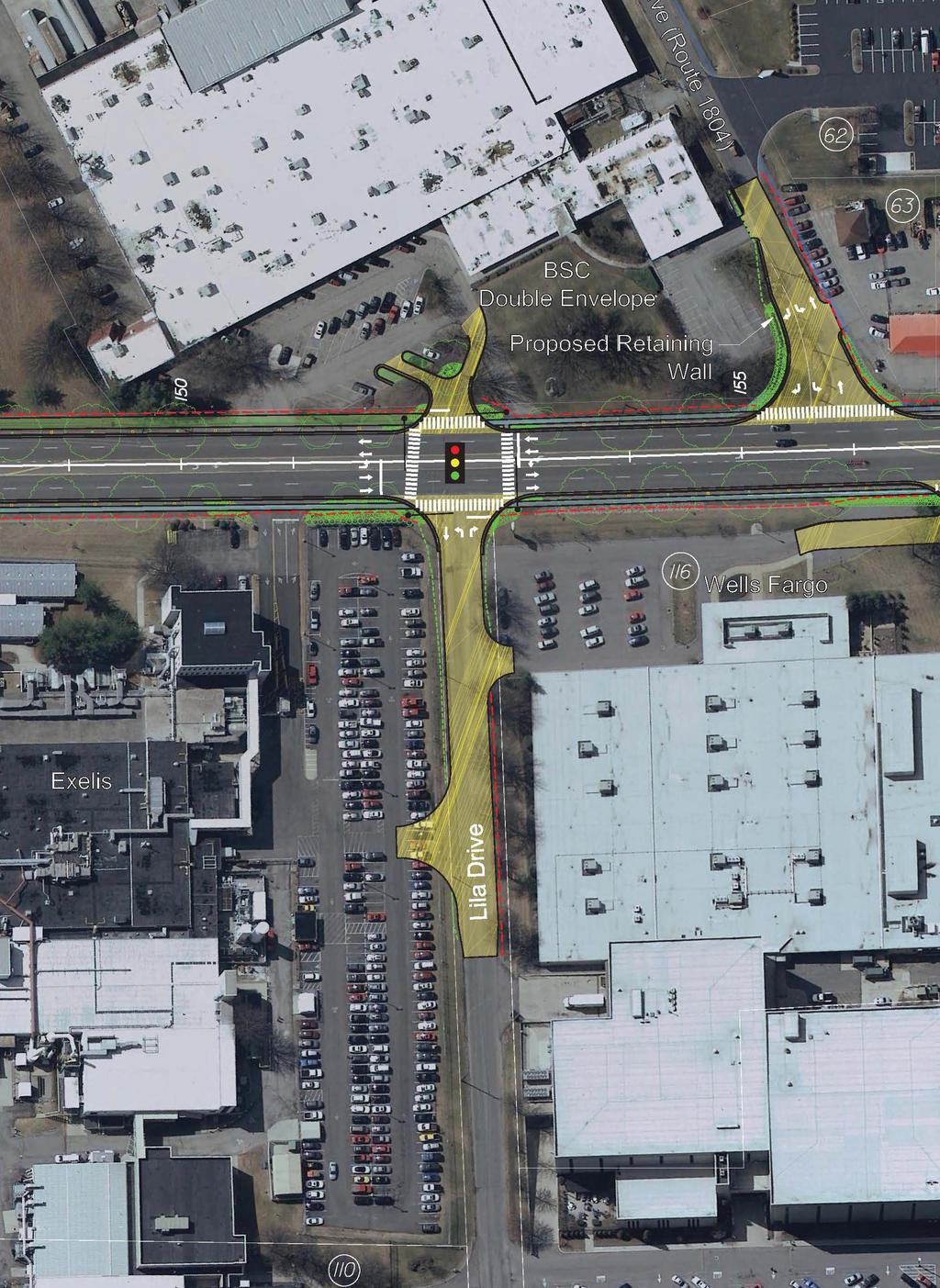
1 Plantation Road Project Lila rive Intersection County of Roanoke, Virginia Fiscal Year 2016 Regional Surface Transportation Program Application RSTP Project Profile Candidate Project #2 1. Project Sponsor(s): Roanoke County 2. Proposed Implementing Agency: Roanoke County 3. Project escription and Attached Aerial Showing Proposed Improvement Location: The Lila rive intersection is a critical component of the Plantation Road Bicycle, Pedestrian and Streetscape Improvement project (Plantation Road Project). Overall Plantation Road Project improvements include shared use paths, sidewalks, pedestrian crosswalks and signals, street trees, pedestrian-scaled lighting, a Hollins community identification sign, landscaping and drainage improvements. The Lila rive intersection lies in the middle of the Plantation Road project between the three largest employers in the area: Wells Fargo, Exelis, and BSC Ventures/ouble Envelope. The intersection is currently controlled by a stop sign on Lila rive, which is a privately-owned road. A traffic signal with pedestrian crosswalks and signals is proposed for the intersection as a safety improvement, an access management strategy and a location for pedestrians and bicyclists to safely cross Plantation Road. Several private entrance closures and reconfigurations are also proposed as part of the four-legged traffic signal installation. To relocate the Exelis entrance currently situated on Plantation Road, about 420 linear feet of Lila rive will be reconstructed to public road standards to serve the new entrance. This relocated Lila rive Exelis entrance will be utilized by tractor trailers to access the loading dock for deliveries. Internal site reconfigurations at Exelis will be needed in order to facilitate this new entrance. The project qualifies for the Regional Surface Transportation Program under the following eligibility categories: Pedestrian and/or Bicycle Improvements: AA Ramps, Crosswalks and Signalization Highway Capacity, Accessibility, and Operational Improvements: Intersection Improvements Corridor Operational Improvements 4. etailed Scope of Work, proposed Schedule and Relation to Other Projects or Project Phases, Project Status and Other Funding Sources: etailed Scope of Work 1. Surveying 2. Final esign 3. Right-of-Way Acquisition 4. Advertisement 5. Construction Proposed Schedule Tentative ate Activity Summer, 2015 Award otification Winter, 2015/2016 Surveying/Final esign Spring, 2016 Right-of-Way Acquisition Fall, 2016 Construction Advertisement Spring, 2017 Construction Relation to Other Projects or Project Phases The Plantation Road Bicycle, Pedestrian and Streetscape Improvement Project was conceived in 2009 as a means to begin implementing several strategies included in the Hollins Area Plan which was adopted by the Roanoke County Board of Supervisors in ovember, 2008, as a component of the Roanoke County Comprehensive Plan. The Plantation Road Project has received about $3.8 million (including matching funds) in funding from the Revenue Sharing Program, the Transportation Enhancement Program, the Transportation Alternatives Program and the Regional Surface Transportation Program. Roanoke County contracted with Whitman, Requardt and Associates in August, 2013, to begin preliminary Page 1
2 Plantation Road Project Lila rive Intersection County of Roanoke, Virginia Fiscal Year 2016 Regional Surface Transportation Program Application engineering of the project. Outreach to area businesses, organizations and other stakeholders started in September and continued into ecember, Substantial feedback was received from a Citizen Information Meeting held in January, 2014, where conceptual project plans were presented to the public. In March, 2014, VOT determined that the Lila rive traffic signal, crosswalks, 420 feet of road reconstruction to public road standards, entrance changes and on-site reconfigurations at Exelis and BSC Ventures/ouble Envelope were allowable project costs as all of these improvements would contribute to enhanced access management on the corridor. While Roanoke County welcomed this determination, the newly-allowable project costs had not previously been included in Plantation Road Project estimates because until this time, Roanoke County had been advised that the traffic signal and road reconstruction could not be paid for with VOT funds. Roanoke County is now requesting additional VOT funds to construct the Lila rive intersection and associated road reconstruction. Project Status The Virginia epartment of Transportation has agreed to the installation of a traffic signal at the intersection of Plantation Road and Lila rive based upon a Traffic Signal Warrants Analysis performed by Whitman, Requardt and Associates. Preliminary engineering is complete for the traffic signal, crosswalks, entrance relocations and for about 420 feet of Lila rive road reconstruction to meet VOT public road standards. Plantation Road surveying is complete; Lila rive surveying is needed. Lila rive was included in the Army Corps of Engineers Jurisdictional Waters etermination Request. The Programmatic Categorical Exclusion for the Plantation Road Project will need to be modified. Other Funding Sources o other sources of funding are available at this time. 5. Functional Classification: Plantation Road: Urban Principal Arterial Lila rive: Private Road (Propose about 420 feet will be constructed to public road standards) 6. Existing Traffic Volume and Level of Service with Improvement: 2010 Existing Level of Service for Plantation Road (2012 Plantation Road Corridor Study) irection Plantation Road Cross Street AM Midday PM orthbound Williamson Road F F F Friendship Lane/Gander Way B A B Overall C Southbound Williamson Road C C Friendship Lane/Gander Way B C Overall C C 7. Existing Volume/Capacity: Plantation Road Segment Average aily Traffic (2012 Plantation Road Corridor Study) Annual Average aily Traffic Volume Estimates (2013 VOT) Interstate 81 to Friendship Lane/Gander Way 16,327 12,000 Friendship Lane/Gander Way to Walrond rive 15,642 (I-81 to Indian Road) Hitech Road to Milk-A-Way rive 17,609 Indian Road to Williamson Road (Route 11) 15, Traffic Signal Warrants Analysis for Lila rive Existing Conditions Page 2
3 Plantation Road Project Lila rive Intersection County of Roanoke, Virginia Fiscal Year 2016 Regional Surface Transportation Program Application Time Period Vehicles per Hour Highest Hour 6 a.m. 9 a.m ,760 8 a.m. 9 a.m. 9 a.m. 12 p.m , a.m. 12 p.m. 12 p.m. 3 p.m. 1, p.m. 2 p.m. 3 p.m. 6 p.m. 1,064-1,779 5 p.m. 6 p.m. 8. Future Traffic Volume or Projected Ridership with Service Implementation: The proposed Lila rive traffic signal will allow the current volume of vehicles from Lila rive and from BSC Ventures/ouble Envelope to more easily turn onto Plantation Road. Pedestrian signals and crosswalks proposed for the intersection will also enable pedestrians and bicyclists to safely cross five lanes of traffic. 9. Future Volume/Capacity and Level of Service: By consolidating two BSC Ventures/ouble Envelope entrances into one entrance at the proposed Lila rive signal and by relocating one of the main Exelis entrances onto Lila rive, the traffic volume utilizing the intersection and Lila rive will increase. The proposed traffic signal will control this increase in traffic and will result in a better Level of Service, which is particularly needed between the peak hours of 8 a.m. and 9 a.m. as well as between 5 p.m. and 6 p.m. 10. Estimated Project Cost by Phase: (see attached Project Budget for additional detail) Activity Phase for Project Phases 2 and 3 Total Preliminary Engineering $77,500 Right-of-Way Unknown Construction $891,250 Total Cost $968,750 Total RSTP Request $968, RSTP Candidate Project Rating Factors A. Regional Project Consideration The Lila rive intersection and road reconstruction project is an instrumental component of the Plantation Road Bicycle, Pedestrian and Streetscape Improvement Project. While the Plantation Road Project is located within and sponsored by Roanoke County, its benefits and impacts will reach far beyond the County line. Gateway to the Roanoke Valley: The Plantation Road exit off of Interstate 81 is the first entrance into the Roanoke Valley from the north. This important commercial and tourism corridor should present a safe and welcoming gateway to visitors. Regional Employee istribution and Mass Transit Opportunities: Hundreds of employees headed to Plantation-area businesses use Exit 146 and Plantation Road every day; thousands more leave Hollins using Plantation Road to access other parts of the Roanoke Valley and beyond. Several Plantation Road businesses have asked for bus service to the area and a park and ride has also been discussed as a need. Regional Greenway etwork: One of the primary goals of the overall Plantation Road Project is to connect Walrond Park to the Tinker Creek Greenway which leads north to Carvins Cove atural Reserve and will intersect to the south with the Roanoke River Greenway. The localities and organizations involved in these resources include Botetourt County, the City of Roanoke, the Town of Vinton, the City of Salem and the Western Virginia Water Authority. B. Support the Economic Vitality of the Metropolitan Area Improving and expanding the bicycle and pedestrian infrastructure at the Lila rive intersection and within the Plantation Road area will not only help Roanoke County to retain existing Plantation Road-area businesses, but will also encourage new businesses to locate on this corridor. The overall Plantation Road Project is fully expected to encourage new commercial and industrial development in the Plantation Road area, thus providing new tax revenue and new jobs. C. Increase the Safety and Security of the Transportation System Source Identified Safety Issues Proposed Safety Improvements Page 3
4 Page 4 Plantation Road Project Lila rive Intersection County of Roanoke, Virginia Fiscal Year 2016 Regional Surface Transportation Program Application Plantation Road Corridor Study (2012) 8 crashes (no fatalities, 5 injuries) Lila rive/plantation Road intersection; sight distance inadequate Pedestrian traffic without accommodations ew traffic signal with pedestrian signalization and crosswalks at Lila rive/plantation Road intersection Construct sidewalks, shared use paths, pedestrian signals and crosswalks with pedestrian-scaled lighting Plantation Road Safety Issues and Challenges (not included above): Most crashes involve Lila rive traffic turning left (south) onto Plantation Road Heavy traffic volume with a (mostly) undivided, five-lane, shoulder and ditch section with some wide, paved shoulders and only one traffic signal at Friendship Lane/Gander Way; Heavy truck traffic due to the proximity of the interstate and business deliveries; and Left turn movements onto Plantation Road frequently utilize the center lane to merge into traffic. Resulting Behaviors: Exelis employees traveling between the Plantation Road and Hitech Road buildings are encouraged to drive; Pedestrians walk along the paved, gravel or grass shoulders; Employees leaving and retrieving cars at Sunnybrook Garage run across Plantation Road; and Bicyclists riding with traffic are challenged by heavy automobile and truck traffic volumes and frequent commercial entrances. Anticipated Changes due to Proposed Safety Improvements listed above: Exelis employees will use the Lila rive crosswalks and pedestrian signals to safely walk between buildings; Employees will safely cross Plantation Road to walk to area businesses and recreational facilities at lunchtime; and Bicycle travel will be safer when the shared use path and signalized crosswalk are used.. Increase the Accessibility and Mobility Options Available to People and/or Freight The planned Plantation Road sidewalks, shared-use paths, Lila rive intersection crosswalks and pedestrian signals will be designed and constructed to AA standards with accessibility ramps. Area employees, residents, students, customers and visitors of all abilities will be able to utilize the new accommodations. E. Protect and Enhance the Environment, Promote Energy Conservation, and Improve Quality of Life When the proposed traffic signal, crosswalks, pedestrian signals, connecting sidewalks and shared-use paths are complete, reduced vehicle trips and therefore reduced fuel consumption and vehicle emissions are anticipated due to the expected increase in pedestrian and bicycle trips. Reduced vehicle emissions will lead to air quality improvements. These proposed improvements will promote healthy habits by permitting employees, residents, visitors and others to walk and bike for recreation, to walk and bike to restaurants for lunch and to walk and bike to and from work. F. Enhance the Integration and Connectivity of the Transportation System, Across and Between Modes, for People and/or Freight The pedestrian signals and crosswalks planned for the proposed Lila rive intersection will allow pedestrians and bicyclists to safely cross five lanes of traffic on Plantation Road from a planned shared use path on the west side of Plantation Road to a planned sidewalk on the east side of Plantation Road. The planned bicycle and pedestrian accommodations along Plantation Road will connect to Walrond Park and to the Tinker Creek Greenway which accesses over 40 miles of trails at Carvins Cove atural Reserve. G. Promote Efficient System Management and Operation The Plantation Road Corridor Study includes the following recommendations regarding Lila rive to improve the functionality of Plantation Road:
5 Plantation Road Project Lila rive Intersection County of Roanoke, Virginia Fiscal Year 2016 Regional Surface Transportation Program Application Install a traffic signal at Lila rive and connect it with the Friendship Lane/Gander Way signal; and Realign/reconstruct/combine several commercial entrances. Both of these recommendations are proposed for the Lila rive Intersection project. H. Emphasize the Preservation of Existing Transportation System The proposed Lila rive intersection pedestrian signalization and crosswalks connecting to planned shared use paths and sidewalks will promote walking and bicycling while reducing the number of short vehicle trips. Fewer vehicles on the road should extend the life of the existing transportation facility and will reduce the future need to widen Plantation Road to six lanes. I. Cost/Benefit Considerations The completion of the Lila rive Intersection project will result in numerous and incalculable safety benefits for bicycle, pedestrian and vehicular users of the Plantation Road corridor. While also providing safety improvements, the overall Plantation Road Project is also anticipated to increase economic development opportunities, expand transportation options, improve environmental quality and enhance overall quality of life for users. J. Projects included in previous plans that had a public input process associated with the plan: Roanoke County Comprehensive Plan (2005) Hollins Area Plan: Adopted by the Board of Supervisors in 2008 as a component of the Comprehensive Plan; the Plantation Road Project begins to implement the Hollins Area Plan Constrained Long Range Transportation Plan (CLRTP) 2035: Plantation Road is in the Primary System, Vision List Bikeway Plan for the Roanoke Valley Area MPO 2012 Update: Priority alignment: Plantation Road Vision alignments: Walrond rive, Enon rive, Williamson Road 2013 Virginia Outdoors Plan: evelop the Tinker Creek-Carvin Creek trail to connect Carvins Cove with the Roanoke River Greenway and eventually with the Appalachian Trail. (page 10.58) VOT Policy for Integrating Bicycle and Pedestrian Accommodations: Endorses bicycling and walking as fundamental travel modes and integral components of an efficient transportation network Update to the Roanoke Valley Greenway Plan: The planned shared use path network will connect to the Tinker Creek Greenway (Priority #2 in the Plan) located on Hollins University s campus. The Tinker Creek Greenway will ultimately connect the Roanoke River Greenway to the extensive network of established trails at Carvins Cove atural Reserve Hollins University Master Plan: References and endorses the proposed regional greenway connection through Hollins University property. Attachments: 1. Graphic Proposed Lila rive Traffic Signal and Partial Road Reconstruction 2. Graphic Plantation Road/Lila rive Intersection Simulation with Future Traffic Signal 3. Map Plantation Road Project 4. Site Photographs 5. Project Budget 6. Resolution of Support Roanoke County Board of Supervisors Page 5
6

7
 Shared Use")
 I 81 S I 81 ú I 81 RAMP O AT KE ME Y ER S R R L E ST O S R KE Y CI IE FR A ER WA Y PL HI RL GA GA ï 8 9 L : Oâ M O E R I RV CA R")

8 ï â A I A I ú Project Features 8 9 L : O M ï â 8 9 L : O M Traffic Signal Ped Signal Proposed Traffic Signal AGEL L Lila rive Reconstruction Proposed Ped Signal Friendship Lane Reconstruction Proposed Greenways Proposed Construction Hollins Trailhead Parking Lot A I Unbuilt Existing Greenway (Constructed 2012) Shared Use Paths Boat ock Parking Lot Planned Shared Use Paths Walrond Shared Use Path or Sidewalk Proposed Carvins Creek Bridge PLATATIO R Sidewalks Planned Sidewalk I 81 RAMP S Walrond Sidewalk (potential) I 81 S I 81 ú I 81 RAMP O AT KE ME Y ER S R R L E ST O S R KE Y CI IE FR A ER WA Y PL HI RL GA GA ï 8 9 L : Oâ M O E R I RV CA R ST LIL O R W AL LK MI R IT EC H R R AY W A H PA RK R RO R ï 8 9 L : Oâ M O E W AL A R H C ï 8 9 L : Oâ M PO ST R K O LL R BR A E ER R L R FY 2016 Regional Surface Transportation Program SO SO RT BE LL Plantation Road Project - Lila rive Intersection R MA RO E I R O L IA C MC M EM OR Y O MS LIA L I W BA CK R ST Feet 1,000
9 Lila rive Traffic Signal and Road Reconstruction: Site Photographs
 Looking")
10 Plantation Road and Lila rive Intersection (September, 2009) Looking northeast

11 Pedestrian Crossing Plantation Road (Sept, 2009) Looking east, crossing from BSC Ventures/ouble Envelope to Exelis

12 Pedestrian Crossing Plantation Road (Sept, 2011) Looking northeast, crossing from Hitech Road to Exelis

13 Lila rive (September, 2011) Looking west towards Plantation Road Exelis on left, Wells Fargo on right
14 Lila rive Traffic Signal and Partial Road Reconstruction etails Utilizing Whitman, Requardt and Associates Estimates Fiscal Year 2016 Regional Surface Transportation Program SPEC ITEM QUATITIES UIT UIT COST EXTEE 1 Lila rive Roadway Improvements(420 L.F.) 1 LS $ 200, Traffic Signal 1 LS $ 375, Exelis Entrance and Site Accommodations 1 LS $ 200, Sub-Total $ 775, Preliminary Engineering (10%) $ 77, Construction Engineering and Inspections (15%) $ 116, Total $ 968, ROAOKE COUTY COMMUITY EVELOPMET 1 9/25/2014
15 AT A REGULAR MEETIG OF THE BOAR OF SUPERVISORS OF ROAOKE COUTY, VIRGIIA, HEL AT THE ROAOKE COUTY AMIISTRATIO CETER, O TUESAY, SEPTEMBER 23, 2014 RESOLUTIO f REQUESTIG THE ROAOKE VALLEY AREA METROPOLITA PLAIG ORGAIZATIO FU A LIST OF PROJECTS FOR THE FISCAL YEAR REGIOAL SURFACE TRASPORTATIO PROGRAM WHEREAS, the Roanoke Valley Area Metropolitan Planning Organization reviews applications for funding through the Regional Surface Transportation Program and makes recommendations for project funding to the Commonwealth Transportation Board; and WHEREAS, the Roanoke County Board of Supervisors reviewed a list of six (6) projects for Regional Surface Transportation Program funding at a work session on September 9, 2014; and WHEREAS, the Roanoke County Board of Supervisors supports the list of six (6) projects for Regional Surface Transportation Program funding. OW, THEREFORE, BE IT RESOLVE that the Board of Supervisors of Roanoke County, Virginia requests the Roanoke Valley Area Metropolitan Planning Organization fund the following list of projects for the fiscal year Regional Surface Transportation Program: 1. Plantation Road Project Lila rive Intersection 2. Plantation Road Project Friendship / Carvin s Creek Bridge Replacement 3. Plantation Road Project Friendship Lane Reconstruction 4. Plantation Road Project Phase 2 5. Exit 140 Park and Ride Page 1 of 2
16 6. West Main Street Pedestrian Improvements- Phase 2 On motion of Supervisor Mcamara to adopt the resolution, and carried by the following recorded vote: AYES: Supervisors Moore, Bedrosian, Church, Peters, Mcamara AYS: one eborah C. Jacks eputy Clerk to the Bo cc: avid Holladay, Planning Administrator Roanoke Valley Area Metropolitan Planning Organization Page 2of2
Relation to Other Projects or Project. Phases
 Plantation oad Project Phase 2, emaining Improvements County of oanoke, Virginia Fiscal Year 2016 egional Surface Transportation Program Application STP Project Profile Candidate Project #6 1. Project
Environment and Public Works Committee Presentation
 Mixed Use Centers Complete Streets Guidelines Project Environment and Public Works Committee Presentation December 10, 2008 Project Objectives: Conduct an inter-departmental and agency process to study
CITY OF COCOA BEACH 2025 COMPREHENSIVE PLAN. Section VIII Mobility Element Goals, Objectives, and Policies
 CITY OF COCOA BEACH 2025 COMPREHENSIVE PLAN Section VIII Mobility Element Goals, Objectives, and Policies Adopted August 6, 2015 by Ordinance No. 1591 VIII MOBILITY ELEMENT Table of Contents Page Number
Pine Hills Road Pedestrian/Bicycle Safety Study Board of County Commissioners Work Session
 Pine Hills Road Pedestrian/Bicycle Safety Study Board of County Commissioners Work Session February 20, 2018 Meeting Agenda Study Overview Existing Conditions Access Management Potential Gateway Features
Bicycle and Pedestrian Plans and Improvements
 Bicycle and Pedestrian Plans and Improvements Presented to the City Council By Randle Harwood, Planning and Development, and Richard Zavala, Parks and Community Services September 24, 2013 Purpose Review
Route 29 Solutions Projects
 Route 29 Solutions Route 29 Solutions Projects www.route29solutions.org October 10, 2014 Route 29 Widening to Six Lanes Albemarle County This project will widen a 1.8-mile segment of Route 29 from four
TOWN OF PORTLAND, CONNECTICUT COMPLETE STREETS POLICY
 TOWN OF PORTLAND, CONNECTICUT COMPLETE STREETS POLICY I. VISION, GOALS & PRINCIPLES VISION To improve the streets of Portland making them safer and more accessible for all users including pedestrians,
Proposed. City of Grand Junction Complete Streets Policy. Exhibit 10
 Proposed City of Grand Junction Complete Streets Policy Exhibit 10 1 City of Grand Junction Complete Streets Policy Vision: The Complete Streets Vision is to develop a safe, efficient, and reliable travel
APPROVE A RESOLUTION ADOPTING A COMPLETE STREETS POLICY
 STAFF REPORT MEETING DATE: September 13, 2016 TO: FROM: City Council Bob Brown, Community Development Director Russ Thompson, Public Works Director Patrick Filipelli, Management Analyst 922 Machin Avenue
ACTIVE TRANSPORTATION
 ACTIVE TRANSPORTATION Mobility 2040 Supported Goals Improve the availability of transportation options for people and goods. Support travel efficiency measures and system enhancements targeted at congestion
Route 7 Corridor Study
 Route 7 Corridor Study Executive Summary Study Area The following report analyzes a segment of the Virginia State Route 7 corridor. The corridor study area, spanning over 5 miles in length, is a multi
RESOLUTION NO ?? A RESOLUTION OF THE CITY OF NEPTUNE BEACH ADOPTING A COMPLETE STREETS POLICY
 RESOLUTION NO. 2018-?? A RESOLUTION OF THE CITY OF NEPTUNE BEACH ADOPTING A COMPLETE STREETS POLICY WHEREAS, safe, convenient, and accessible transportation for all users is a priority of the City of Neptune
City of Gainesville Transportation/Roadway Needs PROJECT SUMMARY
 A1 Roadway Resurfacing $23,846,000 TYPE: Preservation of existing system Roadway resurfacing A2 Signal Replacement $6,000,000 TYPE: Preservation of existing system Replace traffic signals. B1 W 6th St
Non-Motorized Transportation 7-1
 Non-Motorized Transportation 7-1 Transportation facilities no longer mean just accommodating a vehicle powered by a combustion engine. Pedestrian and non-motorized facilities are important modes of travel
Circulation in Elk Grove includes: Motor vehicles, including cars and trucks
 Circulation, as it is used in this General Plan, refers to the many ways people and goods move from place to place in Elk Grove and the region. Circulation in Elk Grove includes: Motor vehicles, including
5 CIRCULATION AND STREET DESIGN
 5 CIRCULATION AND STREET DESIGN This chapter describes circulation and streetscape improvements proposed for the Northwest Chico Specific Plan Area. It includes detailed design specifications for existing
RESOLUTION NO A RESOLUTION OF THE CITY COUNCIL OF THE CITY OF MENLO PARK ADOPTING A COMPLETE STREETS POLICY
 RESOLUTION NO. 6123 A RESOLUTION OF THE CITY COUNCIL OF THE CITY OF MENLO PARK ADOPTING A COMPLETE STREETS POLICY WHEREAS, the term Complete Streets describes a comprehensive, integrated transportation
BETHEL ROAD AND SEDGWICK ROAD CORRIDOR STUDY
 DRAFT PLAN City Council Meeting August 14, 2017 STUDY AREA Sedgwick Corridor State Route 160, principal arterial with Class 3 access management designation, commuter and freight route, connection to SR
SAN FRANCISCO MUNICIPAL TRANSPORTATION AGENCY
 THIS PRINT COVERS CALENDAR ITEM NO. : 11 DIVISION: Sustainable Streets BRIEF DESCRIPTION: SAN FRANCISCO MUNICIPAL TRANSPORTATION AGENCY Approving traffic modifications on Twin Peaks Boulevard between Christmas
Perryville TOD and Greenway Plan
 Perryville TOD and Greenway Plan Greenway Glossary Pathway: A bicycle and pedestrian path separated from motorized vehicular traffic by an open space, barrier or curb. Multi-use paths may be within the
APPENDIX A: Complete Streets Checklist DRAFT NOVEMBER 2016
 APPENDIX A: Complete Streets Checklist DRAFT NOVEMBER 2016 Complete Streets Checklist MetroPlan Orlando s Complete Streets Checklist is an internal planning tool for staff to further implementation of
Performance Criteria for 2035 Long Range Transportation Plan
 Minimizing Impacts on Natural, Historic, Cultural or Archeological Resources 2035 LRTP Weighting Factor: 7% Objective 1.1: Use appropriate planning and design criteria to protect and enhance the built
West Dimond Blvd Upgrade Jodhpur Street to Sand Lake Road
 West Dimond Blvd Jodhpur St to Sand Lake CSS Transportation Project Summary Municipality of Anchorage Project # 05 005 Project Manager: John Smith, P.E. (MOA PM&E) Project Administrator: Julie Makela,
2018 Pedestrian and Bicycle and Safe Routes to School Application for Funding Page 1 of 31
 2018 Pedestrian and Bicycle and Safe Routes to School Application for Funding Page 1 of 31 2018 Pedestrian and Bicycle and Safe Routes to School Application for Funding Part 1: General Information Funding
Exhibit 1 PLANNING COMMISSION AGENDA ITEM
 Exhibit 1 PLANNING COMMISSION AGENDA ITEM Project Name: Grand Junction Circulation Plan Grand Junction Complete Streets Policy Applicant: City of Grand Junction Representative: David Thornton Address:
4. ENVIRONMENTAL IMPACT ANALYSIS 9. TRANSPORTATION AND TRAFFIC
 4. ENVIRONMENTAL IMPACT ANALYSIS 9. TRANSPORTATION AND TRAFFIC 4.9.1 INTRODUCTION The following section addresses the Proposed Project s impact on transportation and traffic based on the Traffic Study
City of Wilsonville 5 th Street to Kinsman Road Extension Project
 City of Wilsonville 5 th Street to Kinsman Road Walking Tour & Neighborhood Workshop Summary Report Public Outreach Overview On July 18 th, 2017, the City of Wilsonville hosted a neighborhood walking tour
Toward Zero Deaths. Regional SHSP Road Show Meeting. Virginia Strategic Highway Safety Plan. presented by
 Toward Zero Deaths Regional SHSP Road Show Meeting presented by Virginia Strategic Highway Safety Plan December 1, 2016 1 Welcome & Introductions Purpose of the Meeting Objectives & Key Outcomes Agenda»
EXECUTIVE SUMMARY. Vision
 Vision Walking and bicycling in Salt Lake City will be safe, convenient, comfortable, and viable transportation options that connect people to places, foster recreational and economic development opportunities,
New Measure A Expenditure Categories DEFINITIONS OF ELIGIBLE EXPENDITURES Adopted March 8, 2007
 New Measure A Expenditure Categories DEFINITIONS OF ELIGIBLE EXPENDITURES Adopted March 8, 2007 City Street and County Road Maintenance Program The preservation and keeping of public street and road rights-of-way
Chapter 5 Future Transportation
 Chapter 5 Future Transportation The Future Land Use Plan identifies the desired land use designations. The land uses desired for Crozet depend, in large part, on the success of the transportation system,
ORDINANCE NO
 1 Sponsored by: Councilmembers Stan Flemming, Connie Ladenburg, and Rick Talbert 2 Requested by: Executive/Public Works and Utilities - Transportation Services 3 4 5 6 7 10 11 ORDINANCE NO. 2014-445 12
General Plan Circulation Element Update Scoping Meeting April 16, 2014 Santa Ana Senior Center, 424 W. 3rd Street, Santa Ana, CA 92701
 General Plan Circulation Element Update Scoping Meeting April 16, 2014 Santa Ana Senior Center, 424 W. 3rd Street, Santa Ana, CA 92701 Meeting Agenda 1. Purpose of Scoping Meeting 2. Project Overview 3.
Project Description Form 8EE
 Project Description Form 8EE Basic Project Information Submitting Jurisdiction/Agency: Town of Dumfries Project Title: Route 1 (Fraley Blvd) Widening: Brady's Hill Road to Dumfries Road Project Location:
Frequently Asked Questions
 Frequently Asked Questions Business US 190 in Copperas Cove From Avenue D to Constitution Drive What is access management? A. Access Management is a growing effort by government agencies to improve how
Pennsylvania Avenue (CR 484) Design Alternatives Study
 Design Alternatives Study") MEMORANDUM Pennsylvania Avenue (CR 484) Design Alternatives Study Prepared for: APRIL 2016 Prepared By TABLE OF CONTENTS Project Background... 2 Previous Concept... 2 Existing Conditions... 4 New Alternatives...
MEMORANDUM Pennsylvania Avenue (CR 484) Design Alternatives Study Prepared for: APRIL 2016 Prepared By TABLE OF CONTENTS Project Background... 2 Previous Concept... 2 Existing Conditions... 4 New Alternatives...
ACTIVE TRANSPORTATION/NONMOTORIZED TRANSPORTATION
 ACTIVE TRANSPORTATION/NONMOTORIZED TRANSPORTATION BACKGROUND Active transportation, also known as nonmotorized transportation, is increasingly recognized as an important consideration when planning and
NM-POLICY 1: Improve service levels, participation, and options for non-motorized transportation modes throughout the County.
 Transportation PRINCE WILLIAM COUNTY 2008 COMPREHENSIVE PLAN NON-MOTORIZED PLAN CONTENTS Goals, Policies, and Action Strategies Table 4 (Bike Facility Classifications and Descriptions) Table 5 (Bike Facility
Solana Beach Comprehensive Active Transportation Strategy (CATS)
") Solana Beach Comprehensive Active Transportation Strategy (CATS) 3.0 Goals & Policies The Solana Beach CATS goals and objectives outlined below were largely drawn from the Solana Beach Circulation Element
Solana Beach Comprehensive Active Transportation Strategy (CATS) 3.0 Goals & Policies The Solana Beach CATS goals and objectives outlined below were largely drawn from the Solana Beach Circulation Element
TRANSPORTATION ALTERNATIVES PROGRAM: SELECTED PROJECTS AND FUNDING ALLOCATIONS
 ITEM #9: TRANSPORTATION ALTERNATIVES PROGRAM: SELECTED PROJECTS AND FUNDING ALLOCATIONS The Transportation Alternatives Program (TAP) created by MAP-21 requires that 50% of the program funds received by
Regional Transportation Needs Within Southeastern Wisconsin
 Regional Transportation Needs Within Southeastern Wisconsin #118274 May 24, 2006 1 Introduction The Southeastern Wisconsin Regional Planning Commission (SEWRPC) is the official areawide planning agency
Rochester Downtown Bicycle Study 2009
 Rochester Downtown Bicycle Study 2009 Relationship of ROCOG Long Range Transportation Plan to Rochester Comprehensive Plan Regional Long Range Transportation Plan (LRTP) is prepared under the auspices
Executive Summary Route 30 Corridor Master Plan
 Route Corridor Master Plan Project Overview The Route Corridor Master Plan is a coordinated multimodal transportation and land use plan for the entire stretch of Route through East Whiteland Township,
DRAFT BUENA VISTA 2020 TRANSPORTATION PLAN
 DRAFT BUENA VISTA 2020 TRANSPORTATION PLAN DEVELOPED BY THE TRANSPORTATION PLANNING DIVISION OF THE VIRGINIA DEPARTMENT OF TRANSPORTATION IN COOPERATION WITH THE U.S. DEPARTMENT OF TRANSPORTATION, FEDERAL
Welcome! San Jose Avenue Open House August 25, 2015
 Welcome! San Jose Avenue Open House August 25, 2015 Vision Zero The City and County of San Francisco adopted Vision Zero San Francisco Vision Zero High Injury Network as a policy in 2014, committing an
Polk Streetscape Project
 What is this project? The Polk Streetscape Project is an effort to improve safety for everyone traveling on Polk Street between Union and McAllister streets. Also included in this project are paving, sewer
FY 2016 TRANSPORTATION ALTERNATIVES PROGRAM PROJECT SELECTION
 AGENDA ITEM #8: FY 2016 TRANSPORTATION ALTERNATIVES PROGRAM PROJECT SELECTION The Transportation Alternatives Program (TAP) created by MAP-21 requires that 50% of the program funds received by the state
Prince George s County plans, policies, and projects
 Prince George s County plans, policies, and projects Over 250 projects for trails, bikeways, designated bike lanes and sidewalk construction Trail projects that improve access to Metro Sidewalk and trail
DRAFT. Table of Contents. Background
 Douglas County Table of Contents Existing Infrastructure 86 Funding 89 Policy and Program Recommendations 90 Infrastructure Recommendations 92 Conclusion 95 Background Home to 4,500 residents and Baker
Develop a Multi-Modal Transportation Strategy (Theme 6)
") DEVELOP A MULTI-MODAL TRANSPORTATION STRATEGY (THEME 6) WHY IS THIS THEME ADDRESSED? Develop a Multi-Modal Transportation Strategy (Theme 6) Statement of Ideal Reduce resident and visitor reliance on single
DEVELOP A MULTI-MODAL TRANSPORTATION STRATEGY (THEME 6) WHY IS THIS THEME ADDRESSED? Develop a Multi-Modal Transportation Strategy (Theme 6) Statement of Ideal Reduce resident and visitor reliance on single
COWETA HIGH SCHOOL AND EAST HIGHWAY 51
 COWETA HIGH SCHOOL AND EAST HIGHWAY 51 Lack of sidewalks along Ben Lumpkin Rd. Lack of crosswalks and ramps at intersection. Hwy 51 is wide to cross as a pedestrian. No ADA compliance or connection to
2. Vision & Goals. Vision. Santa Rosa is a community where walking and bicycling are comfortable and convenient for people of all ages and abilities.
 2. Vision & Goals Overview The goals of the Santa Rosa Bicycle and Pedestrian Master Plan Update reflect the priorities expressed by the community throughout the public outreach phase of this Plan Update.
SNCC Demographic Trends
 Employment Population SNCC Demographic Trends In 1970 the SNCC population was 10,040, accounting for roughly 3% of the County population In 2015, SNCC grew to 60,567 people, roughly 11% of the County population
AGENDA REPORT. Issue: Discussion of potential improvements on Barnwell Road at Niblick Drive
 AGENDA REPORT To: From: By: Honorable Mayor and City Council Members Warren Hutmacher, City Manager Tom Black, Public Works Director Date: March 23, 2016 Agenda: March 28, 2016 WORK SESSION AGENDA: Barnwell
Vision. Goals and Objectives. Walking
 Vision Walking and biking is an accepted and valued part of everyday life in Portsmouth. People of all ages and abilities include walking and biking as part of their daily activities which helps to make
City of Novi Non-Motorized Master Plan 2011 Executive Summary
 City of Novi Non-Motorized Master Plan 2011 Executive Summary Prepared by: February 28, 2011 Why Plan? Encouraging healthy, active lifestyles through pathway and sidewalk connectivity has been a focus
Funding Sources Appendix I. Appendix I. Funding Sources. Virginia Beach Bikeways and Trails Plan 2011 Page I-1
 Funding Sources Virginia Beach Bikeways and Trails Plan 2011 Page I-1 Funding Sources Federal and state agencies provide funding for local bikeway and trail projects. Descriptions follow for programs that
FY STATEWIDE TRANSPORTATION IMPROVEMENT PROGRAM New Jersey Department of Transportation Projects
 ROUTE/ Project ID No. TIP No. Electrical Load Center Replacement - North 04324 04324 This project will provide for the betterment of the existing highway lighting facilities located along Routes 3, 17
 Time of Change We Are Growing We Are An Attractive Place To Live We Are Age Diverse + Living Longer 50000 40000 30000 20000 10000 0 2010 Census Job Density Housing Sheds Transit Sheds The Project FUNDING
SAN FRANCISCO MUNICIPAL TRANSPORTATION AGENCY
 THIS PRINT COVERS CALENDAR ITEM NO. : 10.3 DIVISION: Sustainable Streets Division BRIEF DESCRIPTION: SAN FRANCISCO MUNICIPAL TRANSPORTATION AGENCY Approving traffic and parking modifications to install
Bicycle and Pedestrian Chapter TPP Update Overview. TAB September 20, 2017
 Bicycle and Pedestrian Chapter TPP Update Overview TAB September 20, 2017 Bicycling & Walking in the Twin Cities Where are we now? The Bike-Pedestrian system Current trends New developments Where are we
1.0 EXECUTIVE SUMMARY
 1.0 EXECUTIVE SUMMARY The Active Transportation Plan is a guide to accomplish the Town s vision for developing a network of sidewalks, on-road bicycle facilities, and trails that allow for safe and convenient
Transportation Master Plan Advisory Task Force
 Transportation Master Plan Advisory Task Force Network Alternatives & Phasing Strategy February 2016 BACKGROUND Table of Contents BACKGROUND Purpose & Introduction 2 Linking the TMP to Key Council Approved
FMATS Transportation Improvement Program Non-Motorized Project Nomination Form
 Project nominations are accepted from the public and are scored based on the adopted Project Scoring Criteria. These criteria assign weight based on the project s impact on the following: 1. Health and
East Burke Transportation, Safety and Capacity Improvements
 East Burke Transportation, Safety and Capacity Improvements The purpose of this project is to increase mobility and improve safety for pedestrians, cyclists, and motor vehicles along VT Route 114 in the
Fitting Light Rail through Well-established Communities
 Fitting Light Rail through Well-established Communities San Francisco 2008 Michael D. Madden Chief, Project Development, Maryland Transit Administration Project Setting Located inside the Capital Beltway
Executive Summary. September 3, 2014
 D Executive Summary September 3, 2014 Study Background and Purpose Citizens for Picture Rocks is a community advocacy group representing the Picture Rocks Fire Department, Pima County Sheriff s Department,
ARLINGTON COUNTY, VIRGINIA
 ARLINGTON COUNTY, VIRGINIA County Board Agenda Item Meeting of October 15, 2016 DATE: October 7, 2016 SUBJECT: Adoption of amendments to the Master Transportation Plan (MTP) to create a new Pedestrian
Bicycle Master Plan Goals, Strategies, and Policies
 Bicycle Master Plan Goals, Strategies, and Policies Mobilizing 5 This chapter outlines the overarching goals, action statements, and action items Long Beach will take in order to achieve its vision of
Lincoln Highway Streetscape Plan Concept Plan
 Lincoln Highway Streetscape Plan Concept Plan November 14, 2014 Introduction This report provides a summary of conceptual transportation, land use, and design recommendations in the Lincoln Highway Streetscape
REGIONAL BICYCLE AND PEDESTRIAN DESIGN GUIDELINES
 REGIONAL BICYCLE AND PEDESTRIAN DESIGN GUIDELINES November 16, 2011 Deb Humphreys North Central Texas Council of Governments Bicycle and Pedestrian Advisory Committee Snapshot of the Guide 1. Introduction
Overview. Illinois Bike Summit IDOT Complete Streets Policy Presentation. What is a Complete Street? And why build them? And why build them?
 Overview Illinois Bike Summit IDOT Complete Streets Policy Presentation Aren Kriks, P.E. District One Bicycle Coordinator and Bureau of Programming Project Engineer History of Complete Streets IDOT Policy
STONY PLAIN ROAD STREETSCAPE
 Jasper Place Revitalization Strategy: Vision The people involved in the Jasper Place Revitalization Strategy envision: Goal 1: Feeling safe in our community Create a community where feeling safe is common--where
TRASBURG RANSPORTATION
 TRASBURG RANSPORTATION LAN DEVELOPED BY THE TRANSPORTATION PLANNING DIVISION OF THE VIRGINIA DEPARTMENT OF TRANSPORTATION IN COOPERATION WITH THE U.S. DEPARTMENT OF TRANSPORTATION, FEDERAL HIGHWAY ADMINISTRATION
Complete Streets Workshop Follow-up. April 27, 2011 Rockledge City Hall
 Complete Streets Workshop Follow-up April 27, 2011 Rockledge City Hall Agenda Complete Streets draft briefing presentation and sample policy language Share your Complete Streets projects and post workshop
Kelowna On the Move. Pedestrian and Bicycle Master Plan
 Kelowna On the Move Pedestrian and Bicycle Master Plan Executive Summary April 2016 Purpose of the Plan The Pedestrian and Bicycle Master Plan identifies infrastructure, planning, and policy requirements
MAG Town of Cave Creek Bike Study Task 6 Executive Summary and Regional Significance Report
 Page 1 MAG Town of Cave Creek Bike Study Task 6 Executive Summary and Regional Significance Report August 1, 2012 MAG Project #481 Page 2 Task 6 Executive Summary and Regional Significance Report Introduction
TOWN OF WILLIAMSTON, SC BICYCLE AND PEDESTRIAN MASTER PLAN TOWN OF WILLIAMSTON, SC BICYCLE AND PEDESTRIAN MASTER PLAN
 TOWN OF WILLIAMSTON, SC BICYCLE AND PEDESTRIAN MASTER PLAN Americans Want Choices 55% of Americans would rather drive less & walk more. Transit use is growing faster than population or highway travel.
Houma-Thibodaux Metropolitan Planning Organization STP<200K Funding Application APPLICATION
 APPLICATION HOUMA-THIBODAUX METROPOLITAN PLANNING ORGANIZATION (HTMPO) FOR SURFACE TRANSPORTATION PROGRAM (STP
CITY OF CAMBRIDGE 2015 BICYCLE PLAN TOWARDS A BIKABLE FUTURE
 CITY OF CAMBRIDGE 2015 BICYCLE PLAN TOWARDS A BIKABLE FUTURE WHICH FUTURE? CAMBRIDGE MUNICIPAL POLICIES 1992: Vehicle Trip Reduction Ordinance 1998: Parking & Transportation Demand Ordinance 2002: Climate
Chapter 7. Transportation. Transportation Road Network Plan Transit Cyclists Pedestrians Multi-Use and Equestrian Trails
 Chapter 7 Transportation Transportation Road Network Plan Transit Cyclists Pedestrians Multi-Use and Equestrian Trails 7.1 TRANSPORTATION BACKGROUND The District of Maple Ridge faces a number of unique
Madison Urban Area and Dane County. Bicycle Transportation Plan Summary. September Introduction. Bicycle Plan Scope and Planning Process
 Bicycle Transportation Plan Summary Madison Urban Area and Dane County Introduction September 2000 Bicycling is an important mode of transportation in the Madison urban area and countywide that is available
Omaha s Complete Streets Policy
 Omaha s Complete Streets Policy (Adopted August 2015) VISION To create great places and enhance our quality of life, the City of Omaha will provide safe, accessible streets for all users. Complete Streets
WELCOME TO OPEN HOUSE # 1 June 14, 2017
 Langstaff Road Weston Road to Highway 7 Class Environmental Assessment Study WELCOME TO OPEN HOUSE # 1 June 14, 2017 Please sign in and join our mailing list Purpose of Open House #1 & Study Area York
ARTINSVILLE ENRY OUNTY REA RANSPORTATION TUDY
 ARTINSVILLE ENRY OUNTY REA RANSPORTATION TUDY DEVELOPED BY THE TRANSPORTATION AND MOBILITY PLANNING DIVISION OF THE VIRGINIA DEPARTMENT OF TRANSPORTATION IN COOPERATION WITH THE U.S. DEPARTMENT OF TRANSPORTATION,
INDOT Complete Streets Guideline & Policy
 INDOT Complete Streets Guideline & Policy INTRODUCTION The Complete Streets guidelines build upon multiple efforts and promote a multimodal transportation system that is integrated and sustains land use
Comments EXECUTIVE SUMMARY
 Comments 1. Under any Alternatives, MCDOT should provide better at-grade pedestrian crossing of Georgia Avenue and Forest Glen Road, including improved crosswalks with wider medians and adequate signal
Eastern PA Trail Summit October 1, 2018
 Eastern PA Trail Summit October 1, 2018 WHO WE ARE + WHY + WE RE * HERE * * * * * * Session Goals: Discuss how to coordinate planning and design in small, urbanized towns Consider how to develop alternative
Attached for your reference please find project updates on ongoing VDOT construction projects in Southampton County.
 SOUTHAMPTON COUNTY BOARD OF SUPERVISORS Regular Session i July 25, 2016 6. HIGHWAY MATTERS A. PLAN PROJECT UPDATES Attached for your reference please find project updates on ongoing VDOT construction projects
City of Jacksonville Mobility Fee Update
 City of Jacksonville Mobility Fee Update 2017 Preliminary Analysis May 3, 2017 Carnival Cruise lines photo credit Presentation Overview Public Outreach Process Pedestrian and Bicycle Master Plan Study
CHAPTER 5 TRANSPORTATION GOAL
 CHAPTER 5 TRANSPORTATION GOAL Create and sustain a transportation system that meets the demands for existing and future traffic; skillfully integrates existing and planned development; and provides a safe
Multi Modal Transit Access Plan KIPDA ID # 239. Project Type: STUDY
 Multi Modal Transit Access Plan KIPDA ID # 239 Project Type: STUDY Description: In conjunction with the results from Project Gobility and the Transit LOS Analysis, TARC seeks to examine the possibilities
Basalt Creek Transportation Refinement Plan Recommendations
 Basalt Creek Transportation Refinement Plan Recommendations Introduction The Basalt Creek transportation planning effort analyzed future transportation conditions and evaluated alternative strategies for
Living Streets Policy
 Living Streets Policy Introduction Living streets balance the needs of motorists, bicyclists, pedestrians and transit riders in ways that promote safety and convenience, enhance community identity, create
APPENDIX G: INTERSECTION NEEDS AT OKEECHOBEE BOULEVARD
 APPENDIX G: INTERSECTION NEEDS AT OKEECHOBEE BOULEVARD INTERSECTION NEEDS AT SR 7 and OKEECHOBEE BOULEVARD SR 7 Extension Project Development and Environment (PD&E) Study From Okeechobee Boulevard (SR
PROPOSAL: Review of Alaska DOT&PF project 68471, Glacier Highway reconstruction and pedestrian improvements from
 PROPOSAL: Review of Alaska DOT&PF project 68471, Glacier Highway reconstruction and pedestrian improvements from Fritz Cove Rd to Seaview Ave, for consistency with locally adopted plans and ordinances.
City of Sammamish. Welcome. Issaquah-Fall City Road Improvements Project Phase I Design: 242nd Avenue SE to Klahanie Drive SE
 Welcome Welcome to the third community meeting for the Issaquah-Fall City Road Improvements Project. AGENDA 6:00 p.m. Welcome and sign-in 6:10 p.m. Presentation 6:50 p.m. Open house Learn about the roadway
FUNDING SOURCES CHAPTER 6
 CHAPTER 6 6.1 BICYCLE 6.1.1 Local 6.1.2 Regional 6.1.3 State 6.1.4 Federal 6.1.5 Public Facilities 6.1.6 Bicycle Registration and Licensing Fees 6.1.7 Summary Table 6.1 of Bicycle Funding Sources 6 2 6.2
CITY OF BLOOMINGTON COMPLETE STREETS POLICY
 CITY OF BLOOMINGTON COMPLETE STREETS POLICY POLICY OBJECTIVE: The City of Bloomington will enhance safety, mobility, accessibility and convenience for transportation network users of all ages and abilities,
CITY OF SIGNAL HILL Cherry Avenue Signal Hill, CA
 CITY OF SIGNAL HILL 2175 Cherry Avenue Signal Hill, CA 90755-3799 AGENDA ITEM TO: HONORABLE MAYOR AND MEMBERS OF THE CITY COUNCIL FROM: STEVE MYRTER, P. E. DIRECTOR OF PUBLIC WORKS SUBJECT: SPRING STREET