Woodrow Wilson Elementary School Trenton, NJ School Travel Plan
|
|
|
- Charleen Bates
- 6 years ago
- Views:
Transcription


1 Woodrow Wilson Elementary School Trenton, NJ School Travel Plan Prepared by Greater Mercer TMA With Assistance from Alan M. Voorhees Transportation Center; Rutgers, The State University of New Jersey and NJ Partnership for Healthy Kids
2 Woodrow Wilson Elementary School Description: Wilson Elementary School is located at 175 Girard Avenue Trenton, New Jersey. For the school year it houses approximately 400 students from grades K-5. Wilson is one of fifteen elementary schools in the Trenton Public School District. The school day lasts from 8:45am to 3:15pm, but a large number of students arrive early for breakfast which begins at 8am. There is also an after school program that dismisses at 6pm. All students participating in the after school program must be picked up by an adult. Working Groups and Partnerships: Organization City of Trenton Residents East Trenton Collaborative/ NJPHK-Trenton NJ Department of Transportation NJ Partnership for Healthy Kids- Trenton Voorhees Transportation Center Greater Mercer Transportation Management Association Role/ Responsibility Contact Hoggarth Stephen Community Partner Principal Traffic Analyst Community Mother and student Partners Andrew Carten Community Partner acarten@ecityworks.com Elise Bremer-Nei Safe Routes to School Program Key Partner Coordinator elise.bremer-nei@dot.state.nj.us Marissa Davis Key Partner Project Manager mdavis@trentonymca.org Sean Meehan Key Partner Project Manager smeehan@ejb.rutgers.edu Aly Dyson Key Partner Sustainable Transportation Associate extension 237 adyson@gmtma.org School Neighborhood: Wilson Elementary is between Girard Avenue and Houghton Avenue in Trenton. It is surrounded by residential neighborhoods, train tracks, Route 1, a water treatment facility, pocket parks and nearby is George Page Park. George Page Park is a nice place for families to go and children to play, but it is difficult to get to because it is on the far side of North Clinton Avenue. Cars speed very quickly on this road and there are no clearly marked crosswalks. The School is seen below, marked as A.

3 Woodrow Wilson School (A) and surrounding neighborhood Parents drop students off on all sides of the school (red line on map below). There is no one primary location that the parents use to drop off or pick up students. Parking at Wilson is on both the Girard Avenue and Houghton Avenue sides of the school as indicated by the green dashed lines. When teachers pull in or out of parking spaces, they cross the sidewalk next to the school. There is no single driveway, it is a long parking lot that parallels the road and the sidewalk is used as a driveway along the entire route. The afternoon bus line up occurs along the blue dash/dot line on Houghton Avenue. All of the different modes of travel make the area right around Wilson Elementary School a busy place at arrival and dismissal time.
, blue dashed/ dot line is afternoon bus line")
4 Wilson school: Red line is the morning and afternoon parent drop off/ pick up, green dashed lines are teacher parking (where they need to drive across the sidewalk to get in/out), blue dashed/ dot line is afternoon bus line up.
5 Walk and Bike Barriers and Opportunities: In April 2013, a Travel Mode survey was conducted for students at Wilson Elementary. Forty-four percent of students walk to and from the school. Another 20% of students get a ride in a family vehicle in the morning and afternoon. About 20% of students ride the school bus. As shown in the graph below, almost half of the students walk to and from school making walking safety an important issue that needs to be addressed. 50% Morning and Afternoon Travel Mode Comparison 40% Morning Percent of Trips Afternoon 30% 20% 10% 0% Walk Travel Mode Morning Afternoon Bike School Bus Family Vehicle Carpool Morning and Afternoon Travel Mode Comparison number of School Family Walk Bike Carpool Trips Bus Vehicle % 3% 21% 20% 12.0% % 3% 20% 21% 11% Transit Other Transit Other 0% 0% 0% 0% The Trenton Board of Education Transportation Policy 8600 is defined by New Jersey State Law. This indicates that elementary students that live more than 2.1 miles or secondary students that live more than 2.6 miles from school are eligible for transportation. Students living closer to school are not provided transportation unless the student s route is deemed hazardous by the Board of Education.

6 Three Walking routes were evaluated around Woodrow Wilson Elementary School on June 12, The routes have been labeled by color on the map below; green, red and purple. The routes were assembled through information gathered from project partners and through consideration of pedestrian crash data gathered for the surrounding school neighborhood. The blue and red points on them map represent locations of pedestrian crashes that occurred in the surrounding school neighborhood between the years 2003 and During that time period, there were 34 crashes around the school; 4 of them involved a pedestrian under 18 years old. Wilson Elementary School Crash Victim Crash Victim < 18 years old
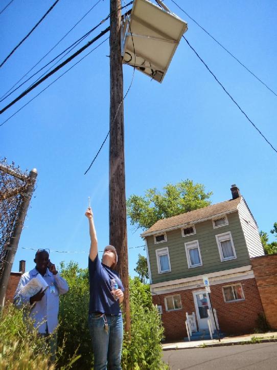
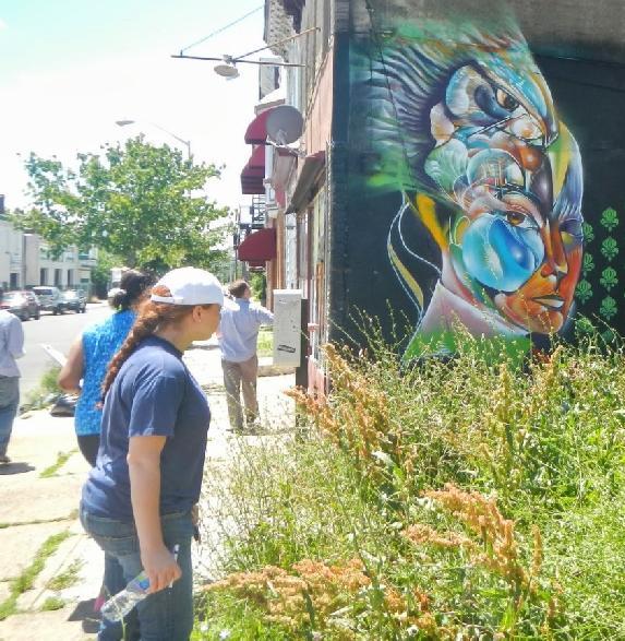
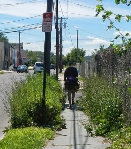
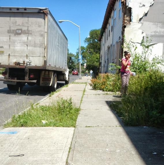
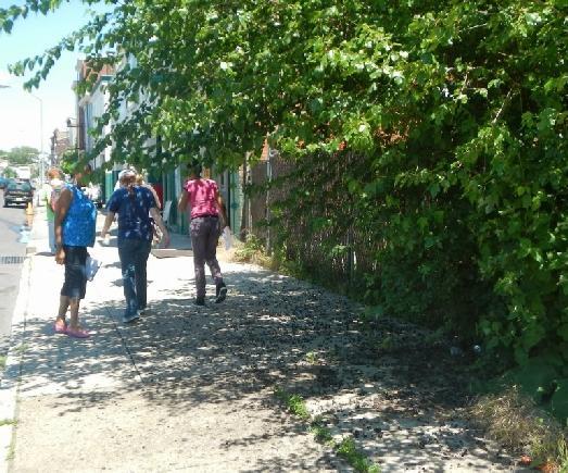
7 Walkability Assessment and Observations: On June 12, 2013, project partners and Safe Routes to School regional Coordinators from the State s eight Transportation Management Associations walked the designated green, red, and purple routes through the neighborhood surrounding Wilson Elementary School, conducting a walkability assessment. Walkability assessments are tools to help a community identify barriers that may make it difficult or dangerous for children to walk to school. These assessments evaluate the sidewalk, road and neighborhood conditions around the school, and identify key safety improvements that can make walking a safer and easier way to get to school. While conducting the walkability assessments, the volunteers took pictures and wrote notes about what they saw. After completing the walkability audits, the groups from each route summarized their observations. The observations and selected pictures below help illustrate what the volunteers recorded. Purple Route Observations: Clinton Avenue: major crossing hard to cross, no speed limit signs, no traffic calming. Cars speeding. No access to park across the street. No road striping or crosswalks Very little pedestrian crossing signage Missing street signs No way to cross street to get to the park Sidewalks badly in need of repair; many broken sidewalk pieces are dangerous Inadequate lighting Lots of debris, hanging wires, broken telephone poles, dangerous abandoned properties, broken storm grates Car repair shop blocking sidewalk Inadequate ADA ramps at crosswalks Broken truncated domes No way to cross street to access community center Impromptu sidewalk businesses (tables) blocking sidewalks One building s staircase is blocking sidewalk No trash or recycling cans except one broken one obstructing the sidewalk No signage around the fire station Overgrown foliage blocking sidewalk Curb slope needs adjustment There were well-striped crossings parallel to North Clinton There were areas with good sidewalk widths (8 12 ) Community art/murals added to the community sense of place Red Route Observations: Bad blind corner at Courland & Houghten No speed limit signs, no street signs, no school zone signs Significant trash along routes; no trash/recycling bins Missing crosswalks At Olden & North Clinton the crosswalks are funky and the pedestrian signs are facing the wrong way Green Acres lot needs mowing and maintenance Hanging wires on Olden near the bridge Lots of speeding cars and cars riding right through intersections Car parked on the sidewalk on Olden Scary dog at blacksmith shop Missing sidewalk sections everywhere Abandoned properties on Olden and throughout the neighborhood
8 Railroad bridge on Olden in disrepair Inadequate ADA compliance missing curb cuts, bumpy pads, etc. Not many pedestrian signs No pedestrian lighting. Especially near bridge. No law enforcement presence Holes in road surfaces, dangerous sewer grates Sewer grates filled with mud: probably causing flooding Bad truck parking garage an active driveway with no signage and no way to see pedestrians when entering and exiting on Olden. Difficult to cross Olden Church sidewalks were in good condition Large play area at school Pedestrian signal at Olden & North Clinton was present and working Green Route Observations: Crosswalks at intersections are faded or non-existent. Non-existent at Clinton & Girard Lack of ADA compliance at intersections; missing curb ramps Missing sidewalk pieces; tree roots uprooting sidewalk Brick/slate transition of sidewalk is uneven and broken Corner of Trenton and Mechanic has no sidewalk, a blind curve, and parking too close to street corners Gang tags at a crash site Appliance repair store: appliances being moved across the sidewalk; broken TVs in the street Trash in the street, blocking sewer drains Burned-out buildings: many deteriorating; one wall is collapsing at 76 Mechanic General inadequate maintenance in row houses; railings falling apart; broken glass and windows Some street curbs are high and uneven Corner of Girard & St. Joe s has no sidewalks Pedestrian environment in front of school (front entrance) is unpleasant Crime: gang activity in the park; apparent drug corner by bodega Abandoned lots: overgrown, lots of trash One-way streets not clearly labeled Homes along route: in need of repair; no city oversight of ordinances Utilities: splintered pole with nails sticking out; pole with crossed, random wires. Closed, boarded-up library (historic building, pre-civil War). Lot is a junk yard. Need a crossing guard at North Clinton/Girard corner


9 In Need of Improvement: Cars parking on and blocking sidewalks both at the school and in front of neighborhood businesses. (Top Green, Bottom Purple)


10 In Need of Improvement: Missing and faded crosswalks need repainting. (Top Left Red, Top Right Green, Above Red, Middle Right Green, Bottom right Purple)


11 Good: Areas of wide sidewalk in good condition, near St. Joseph s Church. (Red) In Need of Improvement: Litter problem. Many garbage clogged sewer grates. (Green)


12 In Need of Improvement: Many areas missing sidewalks. (Top and Middle Green, Bottom Purple)


13 In Need of Improvement: Many areas of sidewalk in need of repair. (Red)


14 In Need of Improvement: Many corners missing curb cuts and bumpy pads. (Purple) In Need of Improvement: Bumpy pads that need replacing. (Purple)


15 Good: Well marked crosswalk, North Olden Ave. and North Clinton Ave. Freshly painted crosswalk with curb ramps and bumpy pads at North Olden and Dickson Street. (Purple above, Red below)
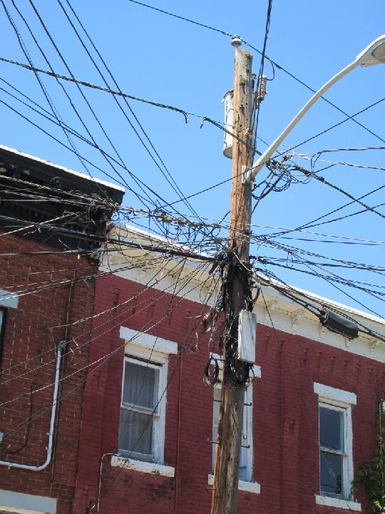
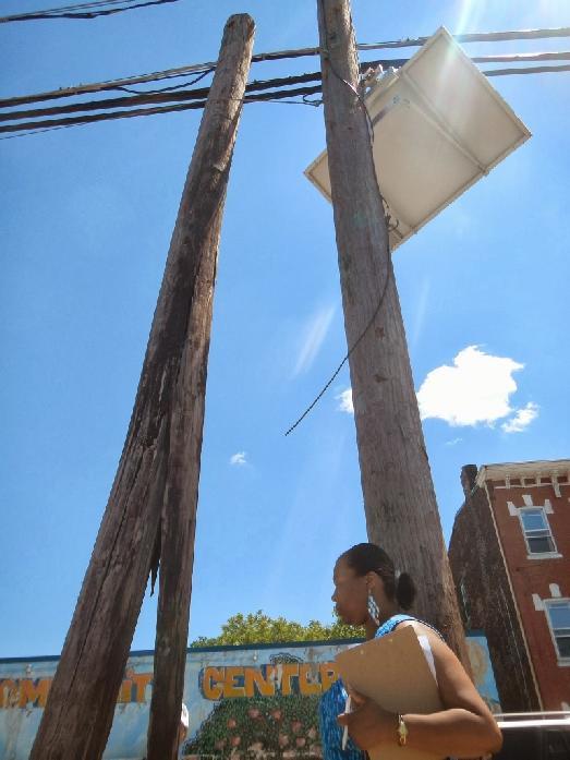
16 In Need of Improvement: Hanging wires and broken utility poles. (Purple)


17 In Need of Improvement: Trash blocking sidewalks. (Left Purple, Below Green) In Need of Improvement: Broken sidewalk doors creating hazards. (Purple)


18 Good: Pedestrian signal at North Olden and North Clinton in place and working. (Red) In Need of Improvement: Missing utility covers expose wires to weather and debris, collect garbage (Purple)
 Good: Mural helps make an")

19 Good: Neighborhood park space. (Green) Good: Mural helps make an attractive walking environment and adds to community sense of place. (Purple)
20 In Need of Improvement: Overgrown trees, shrubs, and greenery blocking sidewalks (Purple)


21 In Need of Improvement: Abandoned properties create unpleasant and intimidating walking environment along North Olden Avenue. (Red)


22 In Need of Improvement: Railroad bridge along North Olden Avenue creates an unpleasant and intimidating walking environment along North Olden Avenue. Sidewalks are broken and uneven, vegetation is overgrown, high fences and opaque bridge walls create an isolating environment that separates pedestrians from view. (Red) In Need of Improvement: Crossing N. Clinton Ave to George Page Park/Assunpink Park is difficult due to high motor vehicle speeds and a skewed intersection.
23 Evaluation- Goals and Action Plan: This plan of action is intended to increase safety for students on their walk to and from school and when appropriate, encourage more students to walk. The table below identifies those actions, a responsible party for implementing them, a time frame, and a level of cost. Many actions identified as short-term and low cost can make a big difference in a short time and can be accomplished with the help of local partners. Engineering Action Responsibility Time Frame Cost Define and enhance school zone. Need additional and replacement signage for speed limit, crosswalks, school zone and advance school zone warning signs. City Public Works, Trenton School District Short Term City Public Works Short/ Long Term Medium City Public Works, School, PTO, Community groups, GMTMA Short Term Fix or replace all sidewalks that are not in are in good condition. This includes fixing broken and replacing missing sidewalks, cutting down overgrown foliage that blocks sidewalk or creates dangerous blind spots, making sidewalks ADA accessible. City public Works Mid-Term Medium Fix flooding issues that may include but are not limited to removing mud and trash from sewer grates. City Public Works Short Term Fix broken and poorly maintained utility poles. City Public Works, Utility Company Short Term Improve pedestrian environment in front of the school to make it more welcoming. Simple actions may include planting trees and flowers and cleaning up trash. School, PTO, Community Groups Short Term Increase the number of crosswalks and fix current crosswalks including pavement stripes, signage, ADA accessibility, flashing crosswalk signs and push to walk buttons and pedestrian signals. Assess all sidewalks.
24 Improve the railroad bridge on North Olden Avenue. Sidewalks need to be fixed and made even, vegetation should be cut back, and opportunities for eliminating the high fences and opaque bridge walls that create an isolating environment and separates pedestrians from view should be investigated. City of Trenton Mid-term Long Term Medium Work with utility companies to ensure that downed wires are fixed and covers on light/utility poles are reinstalled. City of Trenton, Utilities Short Term Define drop-off/ pick up zones for buses and family vehicles. Make sure walkers have a clear way on and off of school property that does not involve dodging buses and personal vehicles. School, Trenton School District Short Term No Speeding was reported as an issue on multiple routes. The area of North Clinton Avenue was specifically reported to contain wide streets with few speed limit signs. Traffic calming techniques such as bulbouts, speed tables, or striping could improve this situation. City of Trenton Mid Term Traffic and engineering study for improving crossing N. Clinton Avenue to neighborhood parks. City of Trenton Long Term MediumHigh Responsibility Time Frame Cost Educate students, family members, bus drivers and school employees about drop-off/ pick up zones. Make sure everyone knows the best way to keep students safe and to quickly dismiss students from school. School, Trenton School District Short Term Increase community outreach about the health benefits of walking and biking to school. School, PTO Short Term Education Action
25 Conduct community wide outreach about Safe Routes to School actions such as education about walking and biking safety. School, GMTMA Short Term/ Ongoing Educate community and responsible parties about snow removal on main thoroughfares to school. City Public Works Short Term/ Ongoing Speak with community and public works about the importance of keeping up with outdoor maintenance. It becomes a safety issue if not conducted regularly. City Public Works, Community Groups Long Term/ Ongoing Community Groups, School Long Term Involve the community in a discussion about how to create a sense of safety in the neighborhood. Work with the community to develop and implement discussion outcomes. Encouragement Action Responsibility Time Frame Cost Establish main walking routes, safety corridors, walking school buses safety in numbers. Map and distribute to the school community in welcome back to school mail prior to the start of the school year. School, PTO, GMTMA, Community Groups Ongoing Participate in an active Safe Routes to School program including not only education, but events to encourage students to walk and/or bike to school. Examples include Golden Sneaker Award, Walking Wednesday, Walking School Bus and other innovative events to encourage safe walking and bicycling. School, PTO, GMTMA, Community Groups Ongoing Conduct a bicycle rodeo to encourage safe bicycling to school. This could include stations about bicycle safety, helmet and bicycle fit, rules of the road, handling skills, and numerous other safety topics PTO, School, Police, Community Groups, GMTMA Short Term
26 Conduct a community clean-up day focusing on routes to school to encourage parents, students, and other community members to improve their neighborhood and come together to support their children. Encourage community to place trash in garbage cans and/or areas that will not block the sidewalks on trash collection days. PTO, School, Police, Community Groups, GMTMA Short Term Encourage community to take action against crime and gang activity in the park- where students could be playing outside. Discourage drug activity near corner Bodega where students frequent. Police, Community Groups Ongoing Responsibility Time Frame Cost Enforce speed limits (in general and specifically in school zones), pedestrians walking safely no jaywalking etc., drivers watching for pedestrians especially at times when students are going to/ from school. Police and City of Trenton Ongoing Enforce parking laws- no parking on sidewalks, in front of hydrants, and driveways. Police and City of Trenton Ongoing Enforce laws about businesses blocking sidewalks with signs, equipment, and vehicles. Creates a danger when drivers and pedestrians can t see each other. Police and City of Trenton Short Term/ Ongoing Enforcement of abandoned property laws. Buildings and properties that are vacant still need to be taken care of. City Public Works Ongoing Police Ongoing Enforcement Action Increase law enforcement presence seen especially in vicinity of Wilson Elementary.
27 Clear parking regulation signs should be posted at all intended drop-off and pick-up locations to better define and support procedures. This can help with community self-enforcement, not requiring excessive police presence. Police, City of Trenton, School Mid-Term Evaluation Action Responsibility Time Frame Cost Conduct periodic mode choice surveys (number and percentage of students who walk or bicycle to school) to better understand any changing travel patterns and to target and assess future efforts. School, PTO GMTMA Short Term/ Ongoing Conduct Student and Parent outreach to see what actions, programs, and rewards could encourage them to walk to school more and feel safer walking to school. School, PTO, GMTMA Short Term *Explanation of funding- Greater Mercer TMA is funded through the New Jersey department of Transportation to offer advice and assistance in starting safe Routes to School programs and projects. Greater Mercer TMA can help with walk and bike to school events, walking school bus programs, youth bicycle and pedestrian education, school travel plans, and surveys that provide evaluation and feedback on local programs.
Monument Elementary School Trenton, NJ School Travel Plan
 Monument Elementary School Trenton, NJ School Travel Plan Prepared by Greater Mercer TMA With Assistance from Alan M. Voorhees Transportation Center; Rutgers, The State University of New Jersey and NJ
Hedgepeth Williams Middle School and Paul Robeson Elementary School Trenton, NJ. School Travel Plan
 Hedgepeth Williams Middle School and Paul Robeson Elementary School Trenton, NJ School Travel Plan Hedgepeth Williams Middle School Description: Hedgepeth-Williams Middle School is located at 301 Gladstone
About the Studio. Edward J. Bloustein School of Planning and Public Policy - Rutgers University
 About the Studio Edward J. Bloustein School of Planning and Public Policy - Rutgers University Purpose of studio: Help City of Bayonne apply for Safe Routes to School (SRTS) funding by producing a School
NORTH LAUDERDALE WALKING AUDIT: VIRTUAL APPENDIX
 NORTH LAUDERDALE WALKING AUDIT: VIRTUAL APPENDIX TABLE OF CONTENTS VIRTUAL APPENDIX A: WALKING AUDIT FINDINGS... 3 Route 1 Notes... 3 Route 2 Notes... 5 Route 3 Notes... 6 Virtual Audit Notes... 8 VIRTUAL
James Williams Middle School 915 Acacia Lane
 James Williams Middle School 915 Acacia Lane Grades Served: 6 th -8 th Student Geography According to an address analysis of students, 36.7% of students attending JWMS live within 2 miles of school (see
C/CAG. Sunnybrae Elementary School Walking and Bicycling Audit. San Mateo-Foster City School District JUNE 2013
 Sunnybrae Elementary School Walking and Bicycling Audit JUNE 2013 San Mateo-Foster City School District C/CAG City/County Association of Governments of San Mateo County SUNNYBRAE ELEMENTARY SCHOOL WALKING
WALKABILITY CHECKLIST How walkable is your community?
 WALKABILITY CHECKLIST How walkable is your community? Everyone benefits from walking and other forms of active transportation. These benefits include: improved fitness, cleaner air, reduced risks of certain
SAFE ROUTES TO SCHOOL
 SAFE ROUTES TO SCHOOL Edgewood Elementary School Existing Conditions and ACTION PLAN > Oak Creek - Franklin Joint School District Table of Contents CONTEXT Enrollment Boundaries Enrollment
7/23/2017 VIA . Michael Hanebutt City of Sacramento Community Development Department 300 Richards Boulevard, 3 rd Floor Sacramento, CA 95811
 7/23/2017 VIA EMAIL Michael Hanebutt City of Sacramento Community Development Department 300 Richards Boulevard, 3 rd Floor Sacramento, CA 95811 RE: 65 th Street Apartments (DR17-220) Dear Mr. Hanebutt:
Safe Routes to School Action Plan Aberdeen, Idaho
 Background Aberdeen, Idaho is a largely agricultural community of nearly 2,000 people and is located in the southeast portion of the state on the western edge of American Falls Reservoir. The community
Fill in the rating for each section. Total up the ratings to see how your neighbourhood scores overall for walkability.
 WALKABILITY CHECKLIST How walkable is your community? Everyone benefits from walking and other forms of active transportation. These benefits include: improved fitness, cleaner air, reduced risks of certain
Rim Rock Elementary School Walking and Biking Audit
 Rim Rock Elementary School Walking and Biking Audit September 29, 2016 Rim Rock Elementary School Audit for Walking and Biking September 29, 2016 Audit Team Members: Sam Atkins, City Engineer, City of
Middle School Walk Audit Booklet
 Safe Routes to School GEORGIA Georgia Department of Transportation Middle School Walk Audit Booklet This Walk Audit Guide was prepared by the Georgia Safe Routes to School Resource Center, funded by the
CITY OF OAK CREEK SAFE ROUTES TO SCHOOL ACTION PLAN. East Middle School
 CITY OF OAK CREEK SAFE ROUTES TO SCHOOL ACTION PLAN East Middle School CITY OF OAK CREEK SAFE ROUTES TO SCHOOL ACTION PLAN East Middle School Why Safe Routes to School? Safe Routes to School ( SRTS ) is
SAFE ROUTES TO SCHOOL (SR2S)
") SAFE ROUTES TO SCHOOL (SR2S) In partnership with Burbank Unified School District (BUSD) & City of Burbank George Washington Elementary School Thomas Jefferson Elementary School John Muir Middle School
SAFE ROUTES TO SCHOOL (SR2S) In partnership with Burbank Unified School District (BUSD) & City of Burbank George Washington Elementary School Thomas Jefferson Elementary School John Muir Middle School
12/4/2016 VIA . RE: Grocery Outlet Del Paso (DR16-328)
") 12/4/2016 VIA EMAIL Ethan Meltzer, Assistant Planner City of Sacramento Community Development Department 300 Richards Blvd, 3 rd Floor Sacramento, CA 95811 RE: Grocery Outlet Del Paso (DR16-328) Dear Mr.
12/4/2016 VIA EMAIL Ethan Meltzer, Assistant Planner City of Sacramento Community Development Department 300 Richards Blvd, 3 rd Floor Sacramento, CA 95811 RE: Grocery Outlet Del Paso (DR16-328) Dear Mr.
Walking Audit Supporting Information
 Walking Audit Supporting Information Planning to do a walking audit of your streets? Here s some helpful suggestions to help get you started. 1. Preparing for your audit Decide where you want to walk.
8/31/2016 VIA . RE: Freeport Arco Fuel Station (P16-039)
") 8/31/2016 VIA EMAIL Garrett Norman, Assistant Planner City of Sacramento Community Development Department 300 Richards Boulevard, 3 rd Floor Sacramento, CA 95811 RE: Freeport Arco Fuel Station (P16-039)
8/31/2016 VIA EMAIL Garrett Norman, Assistant Planner City of Sacramento Community Development Department 300 Richards Boulevard, 3 rd Floor Sacramento, CA 95811 RE: Freeport Arco Fuel Station (P16-039)
Merrick and Memorial Neighborhood Study 5/14/2014 Public Meeting
 Merrick and Memorial Neighborhood Study 5/14/2014 Public Meeting Study Area April 9 Public Meeting Comments Summary Pedestrian Safety - A Walking Neighborhood Pedestrian traffic is very difficult A need
West Capitol Avenue Road Rehabilitation and Safety Enhancement Project
 West Capitol Avenue Road Rehabilitation and Safety Enhancement Project Stakeholder Focus Group Meeting #2 Tuesday, August 28, 2018 7:00 8:00 a.m. West Sacramento City Hall 1110 West Capitol Avenue, West
Sistrunk Corridor DOTMOCRACY SUMMARY
 DOTMOCRACY SUMMARY The TOUCH initiative is a true collaborative working with multi- sector community organizations and agencies to reduce tobacco use and exposure to secondhand smoke, improve access to
Clarkson Walkability Audit: Results and Recommendations Summary
 Clarkson Walkability Audit: Results and Recommendations Summary The following document was prepared by the Region of Peel and includes a summary of comments made by participants during our breakout discussion
MPO Staff Report Technical Advisory Committee: September 13, 2017 MPO Executive Board: September 20, 2017
 MPO Staff Report Technical Advisory Committee: September 13, 2017 MPO Executive Board: September 20, 2017 RECOMMENDED ACTION: Update on Near Southside Walkability Survey. Matter of the Near Southside Neighborhood
Pedestrian, Bicycle and Traffic Calming Strategic Implementation Plan. January 18, 2011
 Pedestrian, Bicycle and Traffic Calming Strategic Implementation Plan January 18, 2011 Tonight s Agenda Receive update on project Provide feedback on two policy issues Complete Streets Policy Project Prioritization
Pedestrian Survey Report
 Pedestrian Survey Report The City of Albany conducted a Pedestrian Survey in 2007 with the purpose of identifying resident s concerns about barriers to walking and accessibility in the City. The survey
SAFE ROUTES TO SCHOOL
 SAFE ROUTES TO SCHOOL Forest Ridge Elementary School Existing Conditions and ACTION PLAN > Oak Creek - Franklin Joint School District Table of Contents CONTEXT Enrollment Boundaries
All Season Age Friendly Pedestrian Safety and Walkability Checklist *
 FOSTERING AGE FRIENDLY, WALKABLE NEIGHBOURHOODS Walkability is a key component of optimal aging in Age Friendly cities. Walkable neighbourhoods promote physical and mental health and well-being, support
David Hung, Associate Planner City of Sacramento Community Development Department 300 Richards Boulevard, 3 rd Floor Sacramento, CA
 June 13, 2016 VIA EMAIL David Hung, Associate Planner City of Sacramento Community Development Department 300 Richards Boulevard, 3 rd Floor Sacramento, CA 959811 RE: Fire Station 14 (DR16-128) Dear Mr.
11/28/2016 VIA
 11/28/2016 VIA EMAIL Ethan Meltzer, Assistant Planner City of Sacramento Community Development Department 300 Richards Blvd., 3 rd Floor Sacramento, Ca 95811 RE: Natomas Corporate Center Commercial Building
July 5, Arthur R. Ware, Jr. Elementary School 2017 Safe Routes to School Walkabout Report
 July 5, 2017 Arthur R. Ware, Jr. Elementary School 2017 Safe Routes to School Walkabout Report 1 Walkabout Report Introduction On April 28, 2017, City, School, and SAWMPO staff met to conduct a Safe Routes
Agenda. Overview PRINCE GEORGE S PLAZA METRO AREA PEDESTRIAN PLAN
 PRINCE GEORGE S PLAZA METRO AREA PEDESTRIAN PLAN May 28, 2008 Agenda Welcome and introductions Project overview and issue identification Planning context and strengths Design challenges and initial recommendations
Everyone is a Pedestrian
 Everyone is a Pedestrian Improving Pedestrian Safety in Texas Transportation and Trinity River Project Committee 26 May 2015 Everyone is a Pedestrian Federal Highway Administration [ FHWA ] Programs to
COWETA HIGH SCHOOL AND EAST HIGHWAY 51
 COWETA HIGH SCHOOL AND EAST HIGHWAY 51 Lack of sidewalks along Ben Lumpkin Rd. Lack of crosswalks and ramps at intersection. Hwy 51 is wide to cross as a pedestrian. No ADA compliance or connection to
F L E T C H E R A V E N U E
 Jan. 29, 2014 Introduction F L E T C H E R A V E N U E FDOT Local Agency Program (LAP) Project FPN: 428214-1-58-01 CIP 63090 Hillsborough County, Traffic Engineering, PWD Stake holders and partners are
Vallecito Elementary School. Travel Plan
 Vallecito Elementary School Travel Plan TABLE OF CONTENTS 1. PURPOSE... 1 1.1. SR2S PLANNING, IMPLEMENTATION AND MONITORING... 1 1.2. MARIN COUNTY MEASURE A... 1 2. VALLECITO ELEMENTARY SCHOOL PROFILE...
Improvements Infrastructure Gap Assessment and Improvements Street Striping
 Infrastructure Project Proposal The federal-aid Safe Routes to School program funds infrastructure/engineering projects that fall into two categories: Design (available only to School Development Authority
Sebastopol Charter School Traffic Management Plan
 Sebastopol Charter School The serves as the working document in support of these essential goals: to ensure the safety and efficiency of student arrival to and departure from school to ensure the safety
6/22/2018 VIA . Darcy Goulart, Planning Manager City of Rancho Cordova Planning Department 2729 Prospect Park Drive Rancho Cordova, CA 95670
 6/22/2018 VIA EMAIL Darcy Goulart, Planning Manager City of Rancho Cordova Planning Department 2729 Prospect Park Drive Rancho Cordova, CA 95670 RE: Quick Quack Car Wash (DD9801) Dear Ms. Goulart: WALKSacramento
Implementing the Three Es of School Zone Traffic Calming
 Implementing the Three Es of School Zone Traffic Calming Use this evaluation tool as a guide to analyze the specific safety needs of your school. SCHOOL PROFILE School Name: School District: Address: Phone
WALKSacrame nto. Welcomes you to the 2009 Sacramento County Safe Routes to School Conference
 Sacramento County Department of Transportation Ron Vicari, Principal Civil Engineer In Partnership with: WALKSacrame nto Anne Geraghty, Terry Preston & Staff Welcomes you to the 2009 Sacramento County
MARTIN LUTHER KING JR. WAY
 OCTOBER 2011 40 Vision and Goals The Martin Luther King, Jr. Way Illustrative Master Plan that follows has been developed through a process of community involvement. It expresses a long term vision for
10/30/2012 VIA
 10/30/2012 VIA EMAIL David Hung, Associate Planner Community Development Department, Current Planning Division City of Sacramento 300 Richards Blvd., 3 rd Floor Sacramento, CA 95811 RE: The Cannery On-Site
Watertown Complete Streets Prioritization Plan. Public Meeting #1 December 14, 2017
 Watertown Complete Streets Prioritization Plan Public Meeting #1 December 14, 2017 Goals for Public Meeting Overview of MassDOT Complete Streets Funding Program Educate the community on Complete Streets
3/10/2016 VIA th Street, Suite 203 Sacramento, CA
 3/10/2016 VIA EMAIL Arwen Wacht, Associate Planner City of Sacramento Community Development Department 300 Richards Boulevard, 3 rd Floor Sacramento, CA 95811 RE: Natomas Fountains (P16-012) Dear Ms. Wacht:
4 GENERIC COST ESTIMATING TOOL
 4 GENERIC COST ESTIMATING TOOL Table 4-1 presents a generic cost estimating tools that can serve as a conceptual planning tool for local jurisdictions to estimate the costs of pedestrian improvements.
PROSPECT ELEMENTARY GIRARD INTERMEDIATE GIRARD JUNIOR HIGH
 PROSPECT ELEMENTARY GIRARD INTERMEDIATE GIRARD JUNIOR HIGH SAFE ROUTES TO SCHOOL SCHOOL TRAVEL PLAN January 8, 2014 2 SECTION 1: OUR SCHOOLS School District School Name School Address Grades served Girard
Microscale Audit of Pedestrian Streetscapes (MAPS), Mini Version
, Mini Version") Microscale Audit of Pedestrian Streetscapes (MAPS), Mini Version Training Manual & Picture Guide Developed by: Carrie Geremia Kelli Cain Revised February 11, 2014 Tool and protocol developed by: James
Microscale Audit of Pedestrian Streetscapes (MAPS), Mini Version Training Manual & Picture Guide Developed by: Carrie Geremia Kelli Cain Revised February 11, 2014 Tool and protocol developed by: James
The DC Pedestrian Master Plan
 The DC Pedestrian Master Plan September 28, 2010 George Branyan Pedestrian Program Coordinator District Department of Transportation Presentation Agenda Scope of the Plan Methodology Recommendations Implementation
o n - m o t o r i z e d transportation is an overlooked element that can greatly enhance the overall quality of life for the community s residents.
 N o n - m o t o r i z e d transportation is an overlooked element that can greatly enhance the overall quality of life for the community s residents. 84 Transportation CHAPTER 11 INTRODUCTION Transportation
SCHOOL CROSSING PROTECTION CRITERIA
 CITY OF MADISON TRAFFIC ENGINEERING SCHOOL CROSSING PROTECTION CRITERIA January 2016 Adopted as Policy on August 31, 1976, by Common Council by Amended Resolution #29,540 Amended on September 14, 1976,
5/7/2013 VIA . RE: University Village Safeway Expansion (P13-019)
") 5/7/2013 VIA EMAIL David Hung, Associate Planner Community Development Department, Current Planning Division City of Sacramento 300 Richards Boulevard, 3 rd Floor Sacramento, CA 95811 RE: University Village
5/7/2013 VIA EMAIL David Hung, Associate Planner Community Development Department, Current Planning Division City of Sacramento 300 Richards Boulevard, 3 rd Floor Sacramento, CA 95811 RE: University Village
Safe Routes to School Travel Plan 2011 Reading-Fleming Intermediate School (RFIS)
") Safe Routes to School Travel Plan 0 Reading-Fleming Intermediate School (RFIS) Reading Fleming Intermediate School 50 Court Street Flemington, NJ 088 Grades: 5-6 Introduction Reading-Fleming Intermediate
Safe Routes to School Travel Plan 0 Reading-Fleming Intermediate School (RFIS) Reading Fleming Intermediate School 50 Court Street Flemington, NJ 088 Grades: 5-6 Introduction Reading-Fleming Intermediate
Tri-State Transportation Campaign Greater Newark Conservancy Newark Complete Streets Walking Audit July 2013
 Tri-State Transportation Campaign Greater Newark Conservancy Newark Complete Streets Walking Audit July 2013 On July 22, 2013, TSTC teamed up with 40 high school student interns and their mentors from
ACTIVE TRANSPORTATION Active Community Checklist
 ACTIVE TRANSPORTATION Active Community Checklist Safe, accessible spaces to walk, hike, bike and play is an important part of building strong, healthy and active communities for residents and visitors.
Regional School District #19 Transportation Policy
 Regional School District #19 Transportation Policy I. Scope of Policy Many students attending E.O. Smith High School are transported by local boards of education, through written agreements with those
Mayor s Bicycle Advisory Council. Wednesday, December 13 th, 2017
 Mayor s Bicycle Advisory Council Wednesday, December 13 th, 2017 Bicyclist Fatalities, Year to Date (January 1 November 30, 2017) - MBAC Briefing Bicyclist Fatality Statistics Year to date total, 2017
CONNECTING PEOPLE TO PLACES
 CONNECTING PEOPLE TO PLACES 82 EAST BENCH MASTER PLAN 07 Introduction The East Bench transportation system is a collection of slow moving, treelined residential streets and major arteries that are the
Summary of School Observations and Education and Encouragement Initiatives
 Rye Shared Committee Summary of School Observations and Education and Encouragement Initiatives Presented to the Rye City Council & The Rye City School District Board of Education April 9 th, 2011 1 Why
20 th Avenue Neighborway Project August 2, Second Open House
 20 th Avenue Neighborway Project August 2, 2018 - Second Open House General Comments We love the plan in general and appreciate the SFMTA looking out for walkers and bikers. Can we get better traffic enforcement
Orange Center Elementary School
 Drag and drop pic and stretch/crop to the limits of the blue rectangle (delete this text box) Orange Center Elementary School Drag and drop pic and stretch/crop to the limits of the blue rectangle (delete
Grandview Heights Safe Routes to School School Travel Plan Ohio Department of Transportation, District 6 February 23, 2012
 Grandview Heights Safe Routes to School School Travel Plan Ohio Department of Transportation, District 6 February 23, 2012 Grandview Heights School Travel Plan (STP) Safe Routes to School Table of Contents
Parental Responsibilities
 Bicycle riding is a fun way to exercise and enjoy the outdoors. To remain safe on Illinois roads, bicyclists must obey the same traffic safety laws that govern vehicle drivers. No amount of bicycle safety
2 Mark Twain Elementary School Report
 2 Mark Twain Elementary School Report Principal: Greg Kaatz Grades: K-2 Enrollment: 323 Address: 425 N. Church Street First bell: 8:10 a.m. Silverton, OR 97381 Last bell: 2:30 p.m. Free & Reduced Lunch:
Ross Valley Safe Routes to Schools Task Force Agenda Friday, May 19 th Ross Valley School District 110 Shaw Drive, San Anselmo Blue Room 10:00 am
 Ross Valley Safe Routes to Schools Task Force Agenda Friday, May 19 th Ross Valley School District 110 Shaw Drive, San Anselmo Blue Room 10:00 am Attendees: Karen Baigrie- Team Leader Hidden Valley, Sean
Summary Report School Walking & Bicycling Audits. Mesa County Regional Transportation Planning Office
 Summary Report School Walking & Bicycling Audits Mesa County Regional Transportation Planning Office This page left blank intentionally WALKING & BICYCLING AUDIT SUMMARY 2 Executive Summary Background:
Active Transportation Audit
 Intersection: Municipality: Audit Conducted By (Name): Time of Audit: Date and Day of Week: Weather Conditions: Active Transportation Audit A. Pedestrian Facilities Please indicate north direction Street
USDOT Pedestrian and Bicycle Safety Assessment Gary, Indiana April 16, 2015
 USDOT Pedestrian and Bicycle Safety Assessment Gary, Indiana April 16, 2015 Secretary Foxx charged USDOT representative to conduct a pedestrian and bicycle assessment in each State by late spring 2015.
THE OFFICIAL GUIDE TO CYCLING SAFELY IN PHILADELPHIA
 B IKE NICE THE OFFICIAL GUIDE TO CYCLING SAFELY IN PHILADELPHIA A partnership of the City of Philadelphia and the Bicycle Coalition of Greater Philadelphia ABOUT VISION ZERO & BIKE NICE It s a great day
Duwamish Way-finding and CTR Report
 V. North Tukwila When the North Tukwila Manufacturing and Industrial Center was designated in 1992 as part of the region s land use and transportation plan, the plan called for the area to set a light-rail
Lawrence Safe Routes to School. Community Meeting January 14, 2015
 Lawrence Safe Routes to School Community Meeting January 14, 2015 Safe Routes to School The 6 E s Education Encouragement Enforcement Engineering Evaluation Equity What are the elements of a SRTS plan?
Steps to Conducting a Complete Streets Assessment
 Steps to Conducting a Complete Streets Assessment Familiarize yourself with Complete Streets Read through the Complete Streets Assessment Guidelines. This will give you an idea of what Complete Streets
ROUTE 81 CORRIDOR STUDY DESIGN CONCEPTS
 RT 81 Corridor Study CLINTON ROUTE 81 CORRIDOR STUDY DESIGN CONCEPTS View north on High Street, with potential improvements to the streetscape Draft Recommendations November 8 th, 2018 TOWN OF CLINTON
Wellington Exempted Village School District SAFE ROUTES TO SCHOOL TRAVEL PLAN January 2014
 Wellington Exempted Village School District SAFE ROUTES TO SCHOOL TRAVEL PLAN January 2014 OHIO SAFE ROUTES TO SCHOOL WELLINGTON EXEMPTED VILLAGE SCHOOL DISTRICT TRAVEL PLAN SECTION 1: WELLINGTON EXEMPTED
FLORIDA DEPARTMENT OF TRANSPORTATION DISTRICT 7 DISTRICT WIDE BICYCLE/PEDESTRIAN ACCESS TO TRANSIT SAFETY ASSESSMENT AND IMPROVEMENT PLAN
 FLORIDA DEPARTMENT OF TRANSPORTATION DISTRICT 7 DISTRICT WIDE BICYCLE/PEDESTRIAN ACCESS TO TRANSIT SAFETY ASSESSMENT AND IMPROVEMENT PLAN TRANSIT SAFETY ASSESSMENT SR 55/US 19 AT 80 TH AVE N DRAFT JUNE
Complete Streets. Designing Streets for Everyone. Sarnia
 Complete Streets Designing Streets for Everyone Sarnia Complete Streets ~ Sarnia ~ 2018 Introduction Our City is made up of a network of streets that we use to go for a walk, cycle to work, drive to the
What Is a Complete Street?
 Session 5 Charleen Zimmer, AICP, Zan Associates May 5-7, 2010 What Is a Complete Street? May 2010 5-1 Not a Complete Street More of a Complete Street May 2010 5-2 Benefits of Complete Streets Safety for
Safe Routes to School NELLIE STONE JOHNSON COMMUNITY SCHOOL
 December 2010 Safe Routes to School NELLIE STONE JOHNSON COMMUNITY SCHOOL Encouraging walking and biking to school Safe Routes to School: Healthy Kids Focused Students Across the nation, communities are
APPENDIX A: Complete Streets Checklist DRAFT NOVEMBER 2016
 APPENDIX A: Complete Streets Checklist DRAFT NOVEMBER 2016 Complete Streets Checklist MetroPlan Orlando s Complete Streets Checklist is an internal planning tool for staff to further implementation of
Ballston Station Multimodal Study WMATA and Arlington County. Meeting Minutes
 Date of Meeting: June 10, 2010 Location: Ballston Metrorail Station and NRECA Building 4301 Wilson Blvd, Arlington, VA Subject: Ballston Station Multimodal Study Stakeholder Meeting #1 Summary: This first
Corpus Christi Metropolitan Transportation Plan Fiscal Year Introduction:
 Introduction: The Safe, Accountable, Flexible, Efficient Transportation Equity Act: A Legacy for Users (SAFETEA-LU) has continued the efforts started through the Intermodal Surface Transportation Efficiency
4/14/2017 VIA . Miriam Lim, Junior Planner City of Sacramento Community Development Department 300 Richards, 3 rd Floor Sacramento, CA 95811
 4/14/2017 VIA EMAIL Miriam Lim, Junior Planner City of Sacramento Community Development Department 300 Richards, 3 rd Floor Sacramento, CA 95811 RE: Mack & Franklin Development (P17-016) Dear Ms. Lim:
Appendix 2- Walkabout Report
 Appendix 2- Walkabout Report School: St Cecilia Catholic School Date: November 9, 2011 Address: 355 Annette St 8:00 a.m to 10:00 a.m Participants: Lorinda Mazza- Principal Katherine Gardiner- Public Health
CHILLICOTHE CITY SCHOOLS. SAFE ROUTES TO SCHOOL TRAVEL PLANS for Allen, Mt. Logan, Tiffin & Worthington Elementary Schools January 2013
 CHILLICOTHE CITY SCHOOLS SAFE ROUTES TO SCHOOL TRAVEL PLANS for Allen, Mt. Logan, Tiffin & Worthington Elementary Schools January 2013 i Ohio s Safe Routes to School Travel Plan Template www.dot.state.oh.us/saferoutes
Johnson Park School Princeton, NJ School Travel Plan May 2016
 Johnson Park School Princeton, NJ School Travel Plan May 2016 Prepared by Greater Mercer TMA Contents School Description... 3 Johnson Park School Description:... 3 Working Groups and Partnerships:... 3
SCHOOL NEIGHBORHOOD CHARACTERISTICS
 SECTION 4 SCHOOL NEIGHBORHOOD CHARACTERISTICS 28 04 SCHOOL NEIGHBORHOOD CHARACTERISTICS School Student Travel Mode Tally Summary Number of PM Trips Walk Bike School Bus Family Vehicle Carpool Public Transit
Why Zone In on Speed Reduction?
 Learn it. Do it. Live it! SPEED REDUCTION IN THE ZONE Why Zone In on Speed Reduction? Speeding is a serious issue that plays a major role in the risk of serious injury and pedestrian fatality in a crash.
Highland Park School Travel Plan
 Highland Park School Travel Plan June 2016 Highland Park School Travel Plan June 2016 Prepared by: Keep Middlesex Moving, Inc. NJ Safe Routes to School Resource Center at the Alan M Voorhees Transportation
5. RUNNINGWAY GUIDELINES
 5. RUNNINGWAY GUIDELINES These guidelines should be considered collectively when making runningway decisions. A runningway is the linear component of the transit system that forms the right-of-way reserved
Forest Hills Improvement Initiative
 Forest Hills Improvement Initiative Transportation Action Plan Short Term Recommendations ONLY Final Draft as of April 30, 2008 For Community Review and Feedback Prepared for: The City of Boston Boston
Arts Center Rail Station Accessibility Assessment
 Arts Center Rail Station Accessibility Assessment Joel Anders, Arnaud Huguet, and Alex Poznanski 25 July 2012 Table of Contents EXECUTIVE SUMMARY... 1 MISSION STATEMENT... 2 OVERVIEW... 2 CROSSWALKS AND
6/14/2013 VIA . Evan Compton, Associate Planner Community Development Department City of Sacramento 300 Richards Blvd Sacramento, CA 95814
 6/14/2013 VIA EMAIL Evan Compton, Associate Planner Community Development Department City of Sacramento 300 Richards Blvd RE: Sacramento Natural Foods Co-Op (P13-025) Dear Mr. Compton: WALKSacramento appreciates
City of Los Angeles. Presentation on Sidewalk Vending
 City of Los Angeles Presentation on Sidewalk Vending Current Sidewalk Vending Governance and Enforcement Los Angeles Municipal Code Current Law Definitions City of Los Angeles Enforcement Department of
Streetscape: Core Shopping District
 Streetscape: Core Shopping District DRAFT DRAFT DRAFT May 00 Core Shopping District: Phase Blue Island s Core Shopping District is located along Western Avenue, between Grove and Union Streets. Streetscape
Bikeway action plan. Bicycle Friendly Community Workshop March 5, 2007 Rochester, MN
 Bikeway action plan Summary The was held on March 5, 2007 at the Rochester Mayo Civic Center. The workshop was hosted by Rochester-Olmsted County Planning Department in collaboration with the League of
Palou Complete Street Project Barneveld Avenue to Crisp Road Project overview and concept design Community Meeting #2 May 13, 2015
 Palou Complete Street Project Barneveld Avenue to Crisp Road Project overview and concept design Community Meeting #2 May 13, 2015 Agenda Welcome and introductions Project overview, history and goals Concept
Chapter 3.9 Timbercrest Elementary School. Volusia County MPO. November 2008
 Chapter 3.9 Timbercrest Elementary School Deltona, FL Volusia County MPO November 2008 Volusia County MPO School Bicycle and Pedestrian Review Study, Phase 3B School Summary Timbercrest Elementary School
San Ramon Elementary School. Travel Plan
 San Ramon Elementary School Travel Plan TABLE OF CONTENTS 1. PURPOSE... 1 1.1. SR2S PLANNING, IMPLEMENTATION AND MONITORING... 1 1.2. MARIN COUNTY MEASURE A... 1 2. SAN RAMON ELEMENTARY SCHOOL PROFILE...
The Corporation of the City of Sarnia. School Crossing Guard Warrant Policy
 The Corporation of the City of Sarnia School Crossing Guard Warrant Policy Table of Contents Overview And Description... 2 Role of the School Crossing Guard... 2 Definition of a Designated School Crossing...
CONNECTIVITY PLAN. Adopted December 5, 2017 City of Virginia Beach
 CONNECTIVITY PLAN Adopted December 5, 2017 City of Virginia Beach CONTENTS 1.0 Background & Purpose... 2 2.0 Existing Inventory & Analysis... 3 ViBe District Existing Walking Conditions... 4 3.0 ViBe District
Safe Routes to School: Valverde Elementary Walk Audit Report. Image: CPLIVE, SkyscraperPage.com
 Safe Routes to School: Valverde Elementary Walk Audit Report Image: CPLIVE, SkyscraperPage.com April 28, 2016 1 OVERVIEW As part of the 2014/2015 Denver Safe Routes to School (SRTS) Program, WalkDenver