Pedestrian Improvements Prepared by Neighborhood Development Services November 2012
|
|
|
- Vivian Hopkins
- 6 years ago
- Views:
Transcription
1 Pedestrian Improvements Prepared by Neighborhood Development Services November 2012

2 Pedestrian Facilities
 New sidewalk")


3 On-going Pedestrian Safety Initiatives (2004 present) New sidewalk construction Safe Routes to School Updating traffic signals Installing LED Crosswalks in high pedestrian commercial areas Upgrading crosswalks to high visibility standards Improving handicap ramps Traffic Calming Bicycle and Pedestrian Safety Committee
4 Pedestrian Safety Efforts LED Crosswalks Market Street at 2nd Street NE (Library) Market Street at 6th Street NE (Garage) Water Street at 1st Street South solar powered McIntire Road at Omni/McDonalds solar powered Avon Street at Hinton Avenue Avon street at Belmont Bridge High Street at Willow Street Numerous on West Main near UVA
5 Pedestrian Safety Efforts ADA Compliant Audio Signals Market Street at 2nd Street NE (Library) Market Street at 6th Street NE (Garage) Water Street at 2nd Street SW solar powered Water Street at 1st Street South solar powered McIntire Road at Omni/McDonalds solar powered Cherry Avenue at Tonsler Park Avon Street at Hinton Avenue High Street at Willow Street
6 City Council Complete Streets Resolution (2010): Roadways that enable safe and convenient access for all users including bicyclists, children, persons with disabilities, motorists, movers of commercial goods, pedestrians, users of public transportation, and seniors.

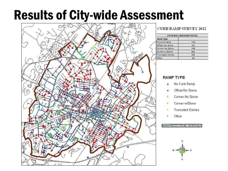
7 Sidewalk Priorities ( ) Prioritization Criteria Commercial and Residential Connections Connected Streets Functional Roadway Classification Low Income Areas Overlap of School Areas Park Access School Proximity Sidewalk exist on one side of the road Transit Stop Access

8 E Current Pedestrian Safety Efforts CAR RO SON FORE DR ALBEMARLE S DALE AVE WINE CELLAR NORTHWOOD CIR PERRY HARRIS 9TH DR McINTIRE 1 N PARKWAY 2ND NE PARK WALKER PLAZA CIR ALTAMONT ALTA HEDG E HIGH PREON MCINTIRE 4TH BROWN T JEFFERSON AVE OLD 5TH ELSOM REAM 6TH S T MARKET 7TH RIDGE COMMERCE 6TH NORTHWOOD CIR DELEVAN SOUTH 4TH DICE T OAK GARRETT GLEASON 2ND 4TH 5TH GRAVES MONTICELLO OAKMONT OAK OB ERTSON LYONS CT LN LN EVERGREEN LEXINGTON AVE PREON AVE 8TH NW WINE MALCOLM CHARLES CRESCENT FARISH GROVE AVE SYCAMORE POPL KELLY AVE AVE LOCU A PARK LN E AVE ALBEMARLE MONT 7TH NW TAYLOR MAPLE HIGH 8 TH MER 9 1/2 JEFFERSON LITTLE HIGH S SNL PLZ 9TH 7TH S T 2ND 3RD 10TH 4TH 2ND 1 5TH MAIN MALL SQ WATER 11TH WATER 12TH FARM LN MARKET E E SOUTH AVON GOODMAN LITTLE GRAVES BELMONT LEVY CARLTON HOLLY DOUGLAS AVE HINTON AVE AVE RIDGE AVE Inventory of ADA accessible curb ramps to support the ADA Transition Plan Signal timing Intersection Improvements Update Standards and Design Manual Safe Streets for All Enforcement Working Group Public service announcements/paid radio advertisements during key events # # # ## # # # # # # # ## # ### # # # # # ## # # # # # # # # ## UCE WALNUT CHURCH AVON 1 CHERRY S ARDEN # ## # # ## # # # # # # ## ## # # AVE # E K

9 Curb ramps are an important part of creating a complete network INSERT Panoramic Picture of Street with Curb Cuts


10 What are curb ramps? A curb ramp is a short ramp cutting through a curb. Provides an accessible route that people of all ages and abilities can use to safely transition from a roadway to a curbed sidewalk and vice versa. Source: Federal Highway Administration, Designing Sidewalks and Trails for Access Part II of II: Best Practices Design Guide
11 What Does Title II of the Americans with Disabilities Act (ADA) Require? State/local gov t must provide curb ramps. Applies if your state/local gov t has responsibility or authority over highways, streets, roads. Prioritizes curb ramps at pedestrian crossings and transit stops where walkways intersect a curb. Curb ramps must meet specific standards for width, slope, cross slope, placement, and other features to the extent feasible
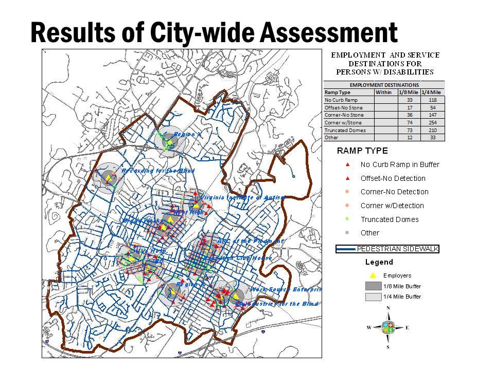
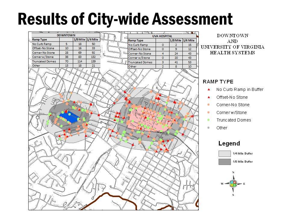
12 What Steps are we Taking to Comply with Title II Requirements? Charlottesville began installing wheelchair friendly ramps in 1994, using the prevailing VDOT standard. City s ADA Transition Plan is now being revised with an aggressive approach to installation and upgrading of curb ramps when streets are altered. City-wide assessment of curb ramps allows us to analyze where curb ramps and upgrades are needed.


13 What do curb ramps look like in our City? Truncated Domes Other Photograph Photograph The City of Charlottesville presently uses the Truncated Domes as its standard for Curb Ramps.


14 What do curb ramps look like in our City? Corner Curb Ramp with Stone Offset Curb Ramp with No Stone Corner Curb Ramp with No Stone
15 Results of City-Wide Assessment Description Total Number Percent Curb ramp is old and does not meet standards % Curb ramp is older. Many, but not all, disabled people can use it % Curb ramp was recently built and should be usable by most, if not all %
16
17
18
19
20
21 ADA Transition Plan Curb Ramp Prioritization No existing curb ramp within a pedestrian travel way (sidewalk/crosswalk) approx. 145 locations Continue to prioritize requests from a person with a disability in areas of high pedestrian activity (prioritization criteria to be developed) No existing curb ramp/dangerous curb ramp providing access to local government facilities, bus stops and other transportation services, public accommodations, business districts, and employment areas Older curb ramp with or without outdated textured concrete (such as aggregate stone)
22 What s planned for FY12? Upgrade curb ramps/crosswalks on High Street (from 9 th Street to Market Street on-ramp) Part of 2010 Pedestrian Study Priority Area Upgrade curb ramps/crosswalks on Avon Street (from Garrett Street to Elliott Ave) Planned repaving Spring 2013 The City will make every effort to place curb ramps at corners of streets being altered and to upgrade existing curb ramps that serve that street
23 Best Practice and Proposed Future Standards When sidewalk width and physically possible, perpendicular curb cuts within the crosswalk will be standard. Diagonal curb ramps will be used when physical constraints and limitations exist.
24 Moving Forward Nearly 2,000 new or improved curb ramps are needed throughout the City Total cost (est) citywide to install/upgrade = $5,994,000. Total cost (est) citywide to install in locations with no curb ramp/dangerous ramp = $2,907,000.
25 Where Do We Go From Here? Approve an aggressive approach to curb ramp installation in ADA Plan update. Work with ADA/Ped Committees to develop a curb ramp priority system. Revise Standards and Design Manual Update Bicycle and Pedestrian Master Plan/Street Design Guidelines Create a user friendly system for citizens to report or propose curb ramps.


26 Thank you City Council Complete Streets Resolution (2010):
ADA Transition Plan. City of Gainesville FY19-FY28. Date: November 5, Prepared by: City Of Gainesville Department of Mobility
 ADA Transition Plan FY19-FY28 Date: November 5, 2018 Prepared by: City Of Gainesville Department of Mobility 1.0 INTRODUCTION 1.1 BACKGROUND The federal statute known as the Americans with Disabilities
CITY OF CHARLOTTESVILLE, VIRGINIA PLANNING COMMISSION AGENDA
 CITY OF CHARLOTTESVILLE, VIRGINIA PLANNING COMMISSION AGENDA Date: February 8, 2011 To: Planning Commission From: Jim Tolbert, AICP Re: Proposed Sidewalk Priorities Background: In 1997 the Planning Commission
CHAPTER. Implementation
 CHAPTER Implementation 5 97 The previous chapters of the Guidelines dealt with the principles and elements of street design in Charlottesville, and this chapter covers the process of getting street projects
WELCOME. Thank you for joining us at the Second Public Workshop for the Carlsbad Pedestrian Master Plan. We look forward to receiving your feedback.
 City of Carlsbad Pedestrian Master Plan: WELCOME WELCOME Please Sign In Provide Input at Flip Charts Review Boards Presentation of Draft Plan Thank you for joining us at the Second Public Workshop for
City of Charlottesville Bicycle and Pedestrian Master Plan Update
 City of Charlottesville Bicycle and Pedestrian Master Plan Update September 17, 2014 I. Welcome and meeting overview II. Project status update III. Network overview IV. Break-out groups Pedestrian Network
Americans with Disabilities Act Transition Plan for Public Right-of-Way Improvements
 Americans with Disabilities Act Transition Plan for Public Right-of-Way Improvements Prepared by: Public Works Department Engineering Division October 2015 Table of Contents Section I Introduction.. 3
ADA TRANSITION PLAN 2013
 ADA TRANSITION PLAN 2013 TABLE OF CONTENTS Contents Introduction 1 Purpose 2 Identified Obstacles to the Public Right of Way 3 Criteria for Determining Impediments at Village Facilities 4 Removing Barriers
Citywide Sidewalk and Crosswalk Programs
 Citywide Sidewalk and Crosswalk Programs Council Meeting October 20, 2015 Presented by Rita Hu and Jamal Mahmoud Program Goals Implement the City s comprehensive plan. Provide pedestrian with safe walking
Pedestrian, Bicycle and Traffic Calming Strategic Implementation Plan. January 18, 2011
 Pedestrian, Bicycle and Traffic Calming Strategic Implementation Plan January 18, 2011 Tonight s Agenda Receive update on project Provide feedback on two policy issues Complete Streets Policy Project Prioritization
Watertown Complete Streets Prioritization Plan. Public Meeting #1 December 14, 2017
 Watertown Complete Streets Prioritization Plan Public Meeting #1 December 14, 2017 Goals for Public Meeting Overview of MassDOT Complete Streets Funding Program Educate the community on Complete Streets
Bicycle and Pedestrian Master Plan Status Update (as of Dec. 2017)
") Bicycle and Pedestrian Master Plan Status Update (as of Dec. 2017) In September 2015, the City Council adopted the Bicycle and Pedestrian Master Plan as an amendment to the City s Comprehensive Plan (2013).
Bicycle and Pedestrian Master Plan Status Update (as of Dec. 2017) In September 2015, the City Council adopted the Bicycle and Pedestrian Master Plan as an amendment to the City s Comprehensive Plan (2013).
Complete Streets Funding Program Project Prioritization Plan
 Funding Program Project Prioritization Plan Location and Type Needs South Street Crosswalk Installation Stripe a new formalized crosswalk across South Street at the Anne T. Dunphy School pedestrian path
Town of Bourbon. Americans with Disabilities Act Transition Plan: Pedestrian Facilities in the Public Right-of-Way
 Town of Bourbon Americans with Disabilities Act Transition Plan: Pedestrian Facilities in the Public Right-of-Way Table of Contents Introduction... 1 Legal Requirements... 1 Identified Obstacles to the
AMERICANS WITH DISABILITIES ACT TRANSITION PLAN LEON COUNTY FOR CURB RAMPS AND SIDEWALKS DEPARTMENT OF PUBLIC WORKS. 1 P age
 AMERICANS WITH DISABILITIES ACT TRANSITION PLAN FOR CURB RAMPS AND SIDEWALKS 2015 LEON COUNTY DEPARTMENT OF PUBLIC WORKS 1 P age INTRODUCTION The goal of the Americans with Disabilities Act (ADA) Transition
ADA Technical Frequently Asked Questions
 ADA Technical Frequently Asked Questions 1. What is the correct way to select and label curb ramp types using the Standard Construction Details?... 2 2. When do you label a curb ramp as modified (e.g.
Roosevelt Estates Neighborhood Improvements
 Roosevelt Estates Neighborhood Improvements Transportation Alternatives Application May 5 th, 2016 Qualifying Activities Construction of on-road and off-road trail facilities for pedestrians, bicyclists,
Village of Lyons. Americans with Disabilities Act Transition Plan: Pedestrian Facilities in the Public Right-of-Way.
 Village of Lyons 76 William Street, Lyons, NY 14489 Phone: 315-946-4531, Fax 315-946-6206 Website: www.lyonsny.com August 15, 2013 Americans with Disabilities Act Transition Plan: Pedestrian Facilities
Town of Wakarusa. Americans with Disabilities Act Transition Plan: Pedestrian Facilities in the Public Right-of-Way
 Town of Wakarusa Americans with Disabilities Act Transition Plan: Pedestrian Facilities in the Public Right-of-Way Table of Contents Introduction... 1 Legal Requirements... 1 Identified Obstacles to the
Agenda. Overview PRINCE GEORGE S PLAZA METRO AREA PEDESTRIAN PLAN
 PRINCE GEORGE S PLAZA METRO AREA PEDESTRIAN PLAN May 28, 2008 Agenda Welcome and introductions Project overview and issue identification Planning context and strengths Design challenges and initial recommendations
CHAPTER 16 PEDESTRIAN FACILITIES DESIGN AND TECHNICAL CRITERIA TABLE OF CONTENTS
 CHAPTER 16 PEDESTRIAN FACILITIES DESIGN AND TECHNICAL CRITERIA TABLE OF CONTENTS Section Title Page 16.1 General... 16-1 16.1.1 AASHTO Reference... 16-1 16.1.2 ADA Requirements... 16-1 16.2 Sidewalks...
Arlington s Master Transportation Plan
 Arlington s Master Transportation Plan The Master Transportation Plan (MTP) Adopted in eight parts Goals & Policies element and MTP Map adopted in 2007 Bicycle, Pedestrian and Demand and Systems Management
TULSA CITY COUNCIL CAPITAL IMPROVEMENT PROGRAM TASK FORCE MEETING JANUARY
 CITY OF TULSA BICYCLE & PEDESTRIAN INFRASTRUCTURE TULSA CITY COUNCIL CAPITAL IMPROVEMENT PROGRAM TASK FORCE MEETING JANUARY 31, 2013 CITY OF TULSA ENGINEERING SERVICES DEPARTMENT CITY OF TULSA ADA TRANSITION
Proposed. City of Grand Junction Complete Streets Policy. Exhibit 10
 Proposed City of Grand Junction Complete Streets Policy Exhibit 10 1 City of Grand Junction Complete Streets Policy Vision: The Complete Streets Vision is to develop a safe, efficient, and reliable travel
ROUTE 81 CORRIDOR STUDY DESIGN CONCEPTS
 RT 81 Corridor Study CLINTON ROUTE 81 CORRIDOR STUDY DESIGN CONCEPTS View north on High Street, with potential improvements to the streetscape Draft Recommendations November 8 th, 2018 TOWN OF CLINTON
Americans with Disabilities Act and Curb Ramps
 Americans with Disabilities Act and Curb Ramps Katherine Smutzer Standards Engineer, INDOT Purdue Road School Wednesday March 9, 2016 Two Items to Remember All curb ramps, sidewalks and sidewalk driveway
Commerce Street Complete Street Project from Good Latimer Expressway to Exposition Avenue
 Commerce Street Complete Street Project from Good Latimer Expressway to Exposition Avenue T A N Y A B R O O K S A S S I S T A N T D I R E C T O R M O B I L I T Y P L A N N I N G M O B I L I T Y A N D S
ADA & Public Rights of Way
 ADA & Public Rights of Way Overview of Current and Up-coming Requirements FDOT Design Training Expo 2012 Orlando, FL Dean Perkins, RA - ADA Coordinator Florida Department of Transportation Office of Design,
What Is a Complete Street?
 Session 5 Charleen Zimmer, AICP, Zan Associates May 5-7, 2010 What Is a Complete Street? May 2010 5-1 Not a Complete Street More of a Complete Street May 2010 5-2 Benefits of Complete Streets Safety for
Marshall County. Americans with Disabilities Act Transition Plan: Pedestrian Facilities in the Public Right-of-Way
 Marshall County Americans with Disabilities Act Transition Plan: Pedestrian Facilities in the Public Right-of-Way 2012 Table of Contents Introduction... 1 Transition Plan History and Overview... 1 Legal
TABLE OF CONTENTS. Executive Summary
 Executive Summary Background... ES-1 Pedestrian Network... ES-2 Bikeway Network... ES-2 Collision History... ES-2 Public Input... ES-4 Conclusions and Recommendations... ES-4 1. Introduction and Setting
DOWNTOWN MIAMI PEDESTRIAN PRIORITY ZONE
 DOWNTOWN MIAMI PEDESTRIAN PRIORITY ZONE AUGUST 6, 2013 DOWNTOWN MIAMI BY THE NUMBERS more than 200,000 people live, work, and play here every day is home to more than 1,000 events each year hosts more
Complete Streets Needs. Complete Streets Project Origin (planning documentation or supporting analysis)
") Mobility MassDOT Program Project Prioritization Plan (Revised 3/31/16) Municipality Winchendon 7/25/2017 Location Needs Request Schedule 1 Development of roundabout at the intersection of Front Street
Mobility MassDOT Program Project Prioritization Plan (Revised 3/31/16) Municipality Winchendon 7/25/2017 Location Needs Request Schedule 1 Development of roundabout at the intersection of Front Street
NM-POLICY 1: Improve service levels, participation, and options for non-motorized transportation modes throughout the County.
 Transportation PRINCE WILLIAM COUNTY 2008 COMPREHENSIVE PLAN NON-MOTORIZED PLAN CONTENTS Goals, Policies, and Action Strategies Table 4 (Bike Facility Classifications and Descriptions) Table 5 (Bike Facility
CITY OF PAPILLION, NEBRASKA
 CITY OF PAPILLION, NEBRASKA PROJECT REPORT For TRANSITION PLAN FOR PEDESTRIAN FACILITIES IN THE PUBLIC RIGHT OF WAY April 2010 Introduction The City of Papillion created an initial Transition Plan in the
Traffic Improvements for the Transit Oriented Development District (TODD) Meriden Public Library March 11, 2014
 Meriden Public Library March 11, 2014") Traffic Improvements for the Transit Oriented Development District (TODD) Meriden Public Library March 11, 2014 Project Overview Coordinate roadway improvements with other major projects HUB Flood Control
Traffic Improvements for the Transit Oriented Development District (TODD) Meriden Public Library March 11, 2014 Project Overview Coordinate roadway improvements with other major projects HUB Flood Control
and older adults and people with disabilities still face barriers when using the pedestrian network and public transportation.
 Background Afterthe1980Olympics,theLakePlacid/NorthElbacommunityadoptedaneconomicstrategy ofdevelopingandmarketingeventstoincreaseareatourism.thisstrategyhasbeenvery successful.overrecentyearsthevolumeofvisitorshasincreased,andthelengthofthe
Michael Parmer, Management Aide, City Manager's Office
 P139 STAFF REPORT f CITY NL- NAGER' S OFFICE RANCHO Date: C;UCAMONGA To: From: Subject: Mayor and Members of the City Council John R. Gillison, City Manager Michael Parmer, Management Aide, City Manager's
Final Sidewalk Feasibility Study
 Garfield Drive From Anastasia Drive to Elizabeth Place City of South Daytona July 23, 2009 Final Sidewalk Feasibility Study Prepared for: Prepared by: Final Sidewalk Feasibility Study Garfield Drive 2
RC-67M has been updated to include more details to be consistent with both ADAAG and PROWAG. The following slides discusses the general notes found
 RC-67M has been updated to include more details to be consistent with both ADAAG and PROWAG. The following slides discusses the general notes found on Sheet 1. RC-67M note Construct curb ramps with a minimum
General Design Factors
 Chapter 3: 3-1.0 Introduction General Design Factors Mn/DOT s goals include encouraging and accommodating safe bicycling. From a design perspective, these goals are achieved by first having an understanding
Roadway Classification Design Standards and Policies. Pueblo, Colorado November, 2004
 Roadway Classification Design Standards and Policies Pueblo, Colorado November, 2004 Table of Contents Page Chapter 1. General Provisions 1.1 Jurisdiction 3 1.2 Purpose and Intent 3 1.3 Modification 3
IMPLEMENTATION STRATEGIES
 GEORGETOWN SIDEWALK MASTER PLAN 34% of funding is dedicated to Downtown Overlay District sidewalks 28% of funding is recommended within 1/4 mile of Southwestern University 26% of funding is recommended
RESOLUTION NO ?? A RESOLUTION OF THE CITY OF NEPTUNE BEACH ADOPTING A COMPLETE STREETS POLICY
 RESOLUTION NO. 2018-?? A RESOLUTION OF THE CITY OF NEPTUNE BEACH ADOPTING A COMPLETE STREETS POLICY WHEREAS, safe, convenient, and accessible transportation for all users is a priority of the City of Neptune
ADA TRANSITION PLAN FOR ACCESSIBILITY OF PEDESTRIAN FACILITIES WITHIN THE PUBLIC RIGHT-OF-WAYS FRANKLIN COUNTY, FLORIDA
 ADA TRANSITION PLAN FOR ACCESSIBILITY OF PEDESTRIAN FACILITIES WITHIN THE PUBLIC RIGHT-OF-WAYS FRANKLIN COUNTY, FLORIDA APPROVED BY THE FRANKLIN COUNTY BOARD OF COUNTY COMMISSIONERS MAY 5, 2015 1 I. INVENTORY
Prince George s County plans, policies, and projects
 Prince George s County plans, policies, and projects Over 250 projects for trails, bikeways, designated bike lanes and sidewalk construction Trail projects that improve access to Metro Sidewalk and trail
DISTRIBUTION: Electronic Recipients List TRANSMITTAL LETTER NO. (17-01) MINNESOTA DEPARTMENT OF TRANSPORTATION. MANUAL: Road Design English Manual
 MINNESOTA DEPARTMENT OF TRANSPORTATION. MANUAL: Road Design English Manual") DISTRIBUTION: Electronic Recipients List MINNESOTA DEPARTMENT OF TRANSPORTATION DEVELOPED BY: Design Standards Unit ISSUED BY: Office of Project Management and Technical Support TRANSMITTAL LETTER NO.
DISTRIBUTION: Electronic Recipients List MINNESOTA DEPARTMENT OF TRANSPORTATION DEVELOPED BY: Design Standards Unit ISSUED BY: Office of Project Management and Technical Support TRANSMITTAL LETTER NO.
APPENDIX A BICYCLE, PEDESTRIAN, AND TRANSIT ASSESSMENT WORKSHEET. B. Subdivision/Site Development Plan/Grading Permit Name and Number:
 APPENDIX A BICYCLE, PEDESTRIAN, AND TRANSIT ASSESSMENT WORKSHEET I. GENERAL INFORMATION A. Project name: B. Subdivision/Site Development Plan/Grading Permit Name and Number: C. Project address: D. Project
DRAFT. Table of Contents. Background
 Douglas County Table of Contents Existing Infrastructure 86 Funding 89 Policy and Program Recommendations 90 Infrastructure Recommendations 92 Conclusion 95 Background Home to 4,500 residents and Baker
Chapter 3.6 Elementary School Z. Volusia County MPO. March Page 13.0
 Chapter 3.6 Elementary School Z DeLand, FL Volusia County MPO March 2008 Page 13.0 Volusia County MPO Bicycle and Pedestrian School Safety Review Study Introduction Elementary School Z is a planned elementary
Appendix T CCMP TRAIL TRAFFIC & TRANSPORTATION DESIGN STANDARD
 Appendix T CCMP 3.3.4 TRAIL TRAFFIC & TRANSPORTATION DESIGN STANDARD 3.3.4 Trail Traffic and Transportation Design Multi-use trails have certain design standards, which vary depending on the agency that
Improvements Infrastructure Gap Assessment and Improvements Street Striping
 Infrastructure Project Proposal The federal-aid Safe Routes to School program funds infrastructure/engineering projects that fall into two categories: Design (available only to School Development Authority
Montclair s Complete Streets Experience
 Presented by: Hon. Jerry Fried, Mayor Montclair Township About Montclair Six square miles Six commuter rail stations Four local bus routes (NJ Transit) Two private commuter bus routes Five business districts
Town of Roseland. Americans with Disabilities Act Transition Plan: Pedestrian Facilities in the Public Right-of-Way
 Town of Roseland Americans with Disabilities Act Transition Plan: Pedestrian Facilities in the Public Right-of-Way Table of Contents Introduction... 1 Legal Requirements... 1 Identified Obstacles to the
Designing Pedestrian Facilities for Accessibility. Module 3 Curb Ramps & Blended Transitions
 Module 3 & Other Purpose: Allow pedestrians to transition between the street and sidewalks, islands, etc. Typically installed at: Intersections (1 ramp at each end of each crosswalk) Mid-block crossings
TRAFFIC ACTION PLAN. Laurie Meadows Neighborhood CITY OF SAN MATEO
 TRAFFIC ACTION PLAN Laurie Meadows Neighborhood CITY OF SAN MATEO Draft January 2017 Table of Contents Introduction... 2 The Traffic Forum Process... 5 Neighborhood Traffic Issues... 7 Neighborhood Recommendations
CITY OF SIGNAL HILL Cherry Avenue Signal Hill, CA
 CITY OF SIGNAL HILL 2175 Cherry Avenue Signal Hill, CA 90755-3799 AGENDA ITEM TO: HONORABLE MAYOR AND MEMBERS OF THE CITY COUNCIL FROM: STEVE MYRTER, P. E. DIRECTOR OF PUBLIC WORKS SUBJECT: SPRING STREET
Living Streets Policy
 Living Streets Policy Introduction Living streets balance the needs of motorists, bicyclists, pedestrians and transit riders in ways that promote safety and convenience, enhance community identity, create
CITY OF KASSON TRANSPORTATION ALTERNATIVES KASSON SAFE ROUTES TO SCHOOL
 ve ha 8t G B A Mantorville Ave N 240th Ave 16th St NE 11th Ave NE K-M HIGH SCHOOL SUNRISE TRAIL TO MANTORVILLE MNTH 57 SUNSET TRAIL TO MANTORVILLE NE PARK 16TH ST NE TRAIL K-M ELEMENTARY SCHOOL K-M MIDDLE
 COMPLETE STREETS CHECKLIST City of Philadelphia The City of Philadelphia's Complete Streets policies are designed ensure that city streets are safe, comfortable and convenient for people of all ages and
City of Gainesville Transportation/Roadway Needs PROJECT SUMMARY
 A1 Roadway Resurfacing $23,846,000 TYPE: Preservation of existing system Roadway resurfacing A2 Signal Replacement $6,000,000 TYPE: Preservation of existing system Replace traffic signals. B1 W 6th St
ACTIVE TRANSPORTATION/NONMOTORIZED TRANSPORTATION
 ACTIVE TRANSPORTATION/NONMOTORIZED TRANSPORTATION BACKGROUND Active transportation, also known as nonmotorized transportation, is increasingly recognized as an important consideration when planning and
CITY MANUALS AND STANDARDS REVIEW
 GEORGETOWN SIDEWALK MASTER PLAN CITY MANUALS AND STANDARDS REVIEW RESOURCES AND STANDARDS As part of the Master Plan process, a review and evaluation of current City documents and policies relevant to
Corpus Christi Metropolitan Transportation Plan Fiscal Year Introduction:
 Introduction: The Safe, Accountable, Flexible, Efficient Transportation Equity Act: A Legacy for Users (SAFETEA-LU) has continued the efforts started through the Intermodal Surface Transportation Efficiency
Scenarios. The following slides will show existing pictures that deny access, followed by a retrofitted picture that provides access.
 Scenarios. The following slides will show existing pictures that deny access, followed by a retrofitted picture that provides access. For the following slides assume an overlay project and provide pedestrian
NJDOT Complete Streets Checklist
 Background The New Jersey Department of Transportation s Complete Streets Policy promotes a comprehensive, integrated, connected multi-modal network by providing connections to bicycling and walking trip
Rightsizing Streets: The Seattle Experience
 Rightsizing Streets: The Seattle Experience April 30, 2013 Brian Dougherty Seattle Department of Transportation Complete Streets 16% of households do not have a car Seniors Youth Transit riders Safety
Access Management Regulations and Standards
 Access Management Regulations and Standards January 2014 Efficient highway operation Reasonable property access Concept of Access Management The way to manage access to land development while preserving
REGIONAL BICYCLE AND PEDESTRIAN DESIGN GUIDELINES
 REGIONAL BICYCLE AND PEDESTRIAN DESIGN GUIDELINES November 16, 2011 Deb Humphreys North Central Texas Council of Governments Bicycle and Pedestrian Advisory Committee Snapshot of the Guide 1. Introduction
PRINCE GEORGE S PLAZA METRO AREA PEDESTRIAN PLAN
 PRINCE GEORGE S PLAZA METRO AREA PEDESTRIAN PLAN May 28, 2008 Agenda Welcome and introductions Project overview and issue identification Planning context and strengths Design challenges and initial recommendations
Pedestrian Project List and Prioritization
 To: Kyle Wagenschutz, City of Memphis CC: From: Anne Conlon and John Cock, Alta Planning + Design Date: December, 2014 Re: Project List Development (Task 3.1-3.2) and Project List Prioritization (Task
Steps to Conducting a Complete Streets Assessment
 Steps to Conducting a Complete Streets Assessment Familiarize yourself with Complete Streets Read through the Complete Streets Assessment Guidelines. This will give you an idea of what Complete Streets
Goodlettsville Bicycle and Pedestrian Plan Executive Summary
 Goodlettsville Bicycle and Pedestrian Plan July 2010 In Cooperation with the Nashville Area Metropolitan Planning Executive Organization Summary Introduction Progressive and forward thinking communities
2018 Transportation Alternatives Program (TAP) Application Presentation to Palm Beach TPA BRANT BRIDGE CONNECTION LOOP EXTENSION ON CARL BOLTER DR
 Application Presentation to Palm Beach TPA BRANT BRIDGE CONNECTION LOOP EXTENSION ON CARL BOLTER DR") 2018 Transportation Alternatives Program (TAP) Application Presentation to Palm Beach TPA BRANT BRIDGE CONNECTION LOOP EXTENSION ON CARL BOLTER DR Project Location N N Connecting South Delray Beach Existing
2018 Transportation Alternatives Program (TAP) Application Presentation to Palm Beach TPA BRANT BRIDGE CONNECTION LOOP EXTENSION ON CARL BOLTER DR Project Location N N Connecting South Delray Beach Existing
This page intentionally left blank.
 This page intentionally left blank. COMMUNITY Glenpool Community Overview Glenpool Glenpool is a city of nearly 12,000 residents located in Tulsa County southwest of Tulsa and Jenks. The city is growing
RESOLUTION NO A RESOLUTION OF THE CITY COUNCIL OF THE CITY OF MENLO PARK ADOPTING A COMPLETE STREETS POLICY
 RESOLUTION NO. 6123 A RESOLUTION OF THE CITY COUNCIL OF THE CITY OF MENLO PARK ADOPTING A COMPLETE STREETS POLICY WHEREAS, the term Complete Streets describes a comprehensive, integrated transportation
A Matter of Fairness: ROCOG s Environmental Justice Protocol. What is Mobility Limitation?
 No Person Left Behind What is Mobility Limitation? What is the Access Limitation? Environmental Justice population should be provided adequate mobility & access to meet their needs; Identify acceptable
APPENDIX A: Complete Streets Checklist DRAFT NOVEMBER 2016
 APPENDIX A: Complete Streets Checklist DRAFT NOVEMBER 2016 Complete Streets Checklist MetroPlan Orlando s Complete Streets Checklist is an internal planning tool for staff to further implementation of
MASTER BICYCLE AND PEDESTRIAN PLAN
 WELCOME! PLEASE FEEL FREE TO REVIEW THE EXHIBITS THE PRESENTATION WILL BEGIN AT 6:00 PM VILLAGE OF NORTHBROOK MASTER BICYCLE AND PEDESTRIAN PLAN DRAFT EXISTING CONDITIONS REPORT AND PUBLIC MEETING WELCOME!
Comments EXECUTIVE SUMMARY
 Comments 1. Under any Alternatives, MCDOT should provide better at-grade pedestrian crossing of Georgia Avenue and Forest Glen Road, including improved crosswalks with wider medians and adequate signal
Bicycle and Pedestrian Connectivity Study. Old Colony Planning Council
 Bicycle and Pedestrian Connectivity Study Old Colony Planning Council Outline Why consider bike/peds in road designs? Why are measures needed? Connecting Land Use with Transportation Evaluation Tools:
TOWN OF PORTLAND, CONNECTICUT COMPLETE STREETS POLICY
 TOWN OF PORTLAND, CONNECTICUT COMPLETE STREETS POLICY I. VISION, GOALS & PRINCIPLES VISION To improve the streets of Portland making them safer and more accessible for all users including pedestrians,
ADA TRANSITION PLAN. TOWN OF DeMOTTE
 ADA TRANSITION PLAN TOWN OF DeMOTTE December 17, 2012 Table of Contents Introduction... 1 Transition Plan Development... 2 A. ADA Coordinator... 2 B. Grievance Procedure... 2 C. Self-Evaluation and Inventory...
2011 Capital Projects University Area - Community Council Priority List Municipality of Anchorage
 2011 Capital Projects University Area - Community Council Priority List Municipality of Anchorage 2 Project Management and Engineering Projects on 40th Ave Extension - Lake Otis Pkwy to Dale St $18,103,000
Board-Approved Funding Awards for Cycle 4 Active Transportation Grant Program Projects (in Order of Project Rankings) Approved on
 Approved on") CAPITAL Large Category Projects Board-Approved Funding Awards for Cycle 4 Active Transportation Grant Program Projects (in Order of Project Rankings) Approved on 07-27-18 1 La Mesa University Ave Pedestrian
CAPITAL Large Category Projects Board-Approved Funding Awards for Cycle 4 Active Transportation Grant Program Projects (in Order of Project Rankings) Approved on 07-27-18 1 La Mesa University Ave Pedestrian
Accommodating Pedestrians in the Work Zone
 Accommodating Pedestrians in the Work Zone Guidance for Section C Plan Preparers Some impacts cannot be avoided and those impacts apply to residents, businesses, motorists, and pedestrians alike. However,
TOWN OF CHAPEL HILL POLICY AND PROCEDURES FOR TRAFFIC CALMING MEASURES
 TOWN OF CHAPEL HILL POLICY AND PROCEDURES FOR TRAFFIC CALMING MEASURES (Adopted by the Town Council on June 30, 2004) (Revised December 6, 2010) (Revised February 8, 2016) POLICY AND PROCEDURES FOR TRAFFIC
This page intentionally left blank.
 This page intentionally left blank. COMMUNITY Coweta Community Overview Coweta Coweta, a residential community located in Wagoner County, is a suburb of Tulsa situated southeast of the metropolitan area
Urbana Pedestrian Master Plan
 Urbana Pedestrian Master Plan Recommendations Gabe Lewis, Transportation Planner Champaign County Regional Planning Commission November 15, 2018 Public Meeting #2 Public Input Round #1 Thank You! 10 public
California Department of Transportation, District 4. Sloat Boulevard Project Skyline Blvd. to 19 th Ave. Community Update January 13, 2016
 California Department of Transportation, District 4 Sloat Boulevard Project Skyline Blvd. to 19 th Ave. Community Update January 13, 2016 Agenda Welcome and introductions Project overview, history and
Hennepin County Pedestrian Plan Public Comment Report
 Hennepin County Pedestrian Plan Public Comment Report On May 31, 2013, the draft Hennepin County Pedestrian Plan was released for a 45-day public comment period ending July 15, 2013. The county received
Charlottesville Bike-Ped Steering Committee Meeting Notes 2/26/2015 Master Plan Update
 Charlottesville Bike-Ped Steering Committee Meeting Notes 2/26/2015 Master Plan Update Streets that Work meeting in December Progress since September SC meeting o Policy o Ped highlights o Bike planning
Rochester Downtown Bicycle Study 2009
 Rochester Downtown Bicycle Study 2009 Relationship of ROCOG Long Range Transportation Plan to Rochester Comprehensive Plan Regional Long Range Transportation Plan (LRTP) is prepared under the auspices
14 TH STREET TRANSPORTATION & STREETSCAPE DESIGN STUDY PLAN B PLAN B TRANSPORTATION & STREETSCAPE RECOMMENDATIONS
 14 TH STREET TRANSPORTATION & STREETSCAPE DESIGN STUDY PLAN B PLAN B TRANSPORTATION & STREETSCAPE RECOMMENDATIONS 141 Symbols Recommendations - Southern End of 14th Street Study Area Streetscape Each icon
Chapter 2. Bellingham Bicycle Master Plan Chapter 2: Policies and Actions
 Chapter 2 Bellingham Bicycle Master Plan Chapter 2: Policies and Actions Chapter 2: Policies and Actions The Bicycle Master Plan provides a road map for making bicycling in Bellingham a viable transportation
HYATTSVILLE TRANSPORTATION PLAN. City Council Update March 19, 2018
 HYATTSVILLE TRANSPORTATION PLAN City Council Update March 19, 2018 AGENDA PROJECT GOALS DATA COLLECTION WHAT WE LEARNED NEXT STEPS PROJECT GOALS Identify bicycle and pedestrian needs of the city Evaluate
Table of Contents Introduction. 2 Purpose of the Plan...2 The Benefits of Walking and Bicycling...3 Vision and Goals of the Plan...
 BICYCLE AND This plan was created through a grant from the Healthy Communities Program with the cooperation of the City of Cynthiana, Cynthiana Main Street, Cynthiana-Harrison County-Berry Joint Planning
EXECUTIVE SUMMARY. Vision
 Vision Walking and bicycling in Salt Lake City will be safe, convenient, comfortable, and viable transportation options that connect people to places, foster recreational and economic development opportunities,
Employment 8,881 17,975 9,094. Households 18,990 31,936 12,946
 This section describes the future transportation environment of the UW Tacoma campus and surrounding area. A description of the future conditions on campus in terms of the street system, traffic and intersection
MEMORANDUM. Sutter Street Bicycle Lanes, Stockton, CA SF
 MEMORANDUM Date: To: From: Subject: PURPOSE Anthony J. Lopes, Siegfried Engineering Christine Carey & Matthew Ridgway, Fehr & Peers Sutter Street Bicycle Lanes, Stockton, CA SF09-0468 The City of Stockton
July 5, Arthur R. Ware, Jr. Elementary School 2017 Safe Routes to School Walkabout Report
 July 5, 2017 Arthur R. Ware, Jr. Elementary School 2017 Safe Routes to School Walkabout Report 1 Walkabout Report Introduction On April 28, 2017, City, School, and SAWMPO staff met to conduct a Safe Routes