Council July 2013 WILMAPCO. Draft TAP Prioritization: FY 14 Cecil Projects. Highway 301 Stream Restoration
|
|
|
- Ferdinand Hancock
- 6 years ago
- Views:
Transcription
1 WILMAPCO Council July 2013 Draft TAP Prioritization: FY 14 Cecil Projects Rising Sun Sidewalks on Mount and North Walnut Streets Bohemia Trail Elkton East High Street and Locust Lane SidewalkImprovements Highway 301 Stream Restoration Bus Stop High load bus stop 0 Community Center Greenway Bike route Hometown Overlay Library Municipality Park Safety School EJ Neighborhood TJ Neighborhood TAZ density Abandoned railroad corridor Historic element Gap Analysis TAP Total
2 WILMAPCO's TRANSPORTATION ALTERNATIVES PROGRAM (TAP) APPLICATION The Transportation Alternatives Program (TAP), authorized under MAP-21, provides funding for programs and small projects defined as transportation alternatives, including on- and off road pedestrian and bicycle facilities, infrastructure projects for improving non-driver access to public transportation and enhanced mobility, community improvement activities, and environmental mitigation; recreational trail program projects; safe routes to school projects; and projects for the planning, design or construction of boulevards and other roadways largely in the right-of-way of former Interstate System routes or other divided highways. Sponsors must be able to provide a minimum of 20 percent funding match. Project submissions will be evaluated using WILMAPCO s project prioritization process, and other factors as determined by Council. For information about Delaware s program, phone or Jeff.Niezgoda@state.de.us, and Maryland s program, phone or jsilwick@sha.state.md.us. SPONSOR: Eligible sponsors include local governments, transit, natural resource or public land agencies, and education agencies/schools. Nonprofits are not eligible as direct recipients, but may partner as secondary sponsors with any eligible entity. Contact Name and Title: Calvin A Bonenberger Jr, Town Administrator Organization: Town of Rising Sun Address: 1 East Main Street City: Rising Sun State: MD Zip: Phone: tabonenberger@risingsunmd.org Secondary Sponsor Organization (if applicable): ELIGIBILITY: For details about eligibility, please visit All projects must have a relationship to surface transportation and must be dedicated to public use. The project must fit into at least one of the activities listed below. Indicate which eligible activities the project will achieve (check all that apply): Transportation Alternatives Construct, plan, and design on-road and off-road trail facilities for pedestrians, bicyclists and other nonmotorized transportation, including sidewalks, bicycle infrastructure, pedestrian and bicycle signals, traffic calming techniques, lighting and other safety-related infrastructure, and transportation projects to achieve ADA compliance. Construct, plan, and design infrastructure-related projects and systems that will provide safe routes for non-drivers, including children, older adults, and individuals with disabilities to access daily needs. Convert and use abandoned railroad corridors for trails for nonmotorized transportation. Construct turnouts, overlooks, and viewing areas Community improvement activities, including: - inventory, control, or removal of outdoor advertising - historic preservation and rehabilitation of historic transportation facilities - vegetation management practices in transportation rights-of-way to improve roadway safety, prevent against invasive species, and provide erosion control - archaeological activities relating to impacts from implementation of a transportation project eligible under title 23 MD Transportation Alternatives Program Manual Application A-1
3 Any environmental mitigation activity, including pollution prevention and pollution abatement activities and mitigation to: - address stormwater management, control, and water pollution prevention or abatement related to highway construction or due to highway runoff, including activities described in sections 133(b)(11), 328(a), and 329 of title 23 - reduce vehicle-caused wildlife mortality or to restore and maintain connectivity among terrestrial or aquatic habitats Safe Routes to School Program, for projects within approximately two miles of a school for kindergarten through eighth grade. Infrastructure-related projects including planning, design, and construction of infrastructure-related projects on any public road or any bicycle or pedestrian pathway or trail in the vicinity of schools that will substantially improve the ability of students to walk and bicycle to school, including sidewalk improvements, on-street bicycle facilities, off-street bicycle and pedestrian facilities, secure bicycle parking facilities, and traffic diversion improvements in the vicinity of schools. Noninfrastructure activities to encourage walking and bicycling to school, including public awareness campaigns and outreach to press and community leaders, traffic education and enforcement in the vicinity of schools, student sessions on bicycle and pedestrian safety, health, and environment, and funding for training, volunteers, and managers of safe routes to school programs. Safe routes to School coordinator Planning, designing, or constructing boulevards and other roadways largely in the right-of-way of former Interstate System routes or other divided highways. The recreational trails program Primary category of eligibility: Construct, plan, and design on-road and off-road trail facilities for pedestrians, bicyclists and other nonmotorized transportation. PROJECT DESCRIPTION (please attach map and/or other supporting information): Design and construct extended sidewalks to planned Triangle Dog Park on east side of Mount Street from Keppells Mills Ct. to N. Walnut St. (Phase 1) and on west side of N. Walnut St. from Mount Street to north of Pogue Ave (Phase 2). In addition to connecting to this planned park, this sidewalk will complete a gap in the town's pedestrian route and connect residents in the project area to the downtown at Rising Sun Middle School. The Town is seeking funding for design and construction of both phases. Work is in coordination with a $150,000 project to construct Triangle Park which includes a dog park, environmental classroom, internal walkways, and environmental mitigation relating to Rt. 1 runoff and cleanup of site from past SHA construction project. MD Transportation Alternatives Program Manual Application A-2
4 Who will maintain the project? What will need to be maintained in the short and long term, and what institution will be responsible for doing so? How does the applicant plan to provide for ongoing maintenance costs? The Town of Rising Sun will maintain the project for both the short- and long-term. Rising Sun will provide for ongoing maintenance costs through their General Fund. FUNDING: Please describe the amount of TAP and matching funds for each phase for which you are seeking funding. Funds are for small projects only, and sponsors must be able to provide a minimum of 20 percent funding match. Funds available for eligible projects on a reimbursement basis administered through the state Departments of Transportation; these funds are not administered as grants. Phase: Concept Plan Funding Amount Phase: Project Development Funding Amount Town of Rising Sun $57, $14, Phase: Construction Funding Amount Town of Rising Sun $222, $55, Yes No Will this amount complete the project? If no, will this amount complete an independent/stand-alone phase of the project? If this request is not fully funded, do you have other funds to complete the project/phase? MD Transportation Alternatives Program Manual Application A-3
5
6 WILMAPCO's TRANSPORTATION ALTERNATIVES PROGRAM (TAP) APPLICATION The Transportation Alternatives Program (TAP), authorized under MAP-21, provides funding for programs and small projects defined as transportation alternatives, including on- and off road pedestrian and bicycle facilities, infrastructure projects for improving non-driver access to public transportation and enhanced mobility, community improvement activities, and environmental mitigation; recreational trail program projects; safe routes to school projects; and projects for the planning, design or construction of boulevards and other roadways largely in the rightof-way of former Interstate System routes or other divided highways. Sponsors must be able to provide a minimum of 20 percent funding match. Project submissions will be evaluated using WILMAPCO s project prioritization process, and other factors as determined by Council. For information about Delaware s program, phone or Jeff.Niezgoda@state.de.us, and Maryland s program, phone or jsilwick@sha.state.md.us. SPONSOR: Eligible sponsors include local governments, transit, natural resource or public land agencies, and education agencies/schools. Nonprofits are not eligible as direct recipients, but may partner as secondary sponsors with any eligible entity. Contact Name and Title: Sandra Edwards, Grants & Program Manager Organization: Town of Chesapeake City Address: 108 Bohemia Ave. City: Chesapeake City State: MD Zip: Phone: s.edwards@chesapeakecity-md.gov Secondary Sponsor Organization (if applicable): N/A ELIGIBILITY: For details about eligibility, please visit All projects must have a relationship to surface transportation and must be dedicated to public use. The project must fit into at least one of the activities listed below. Indicate which eligible activities the project will achieve (check all that apply): Transportation Alternatives Construct, plan, and design on-road and off-road trail facilities for pedestrians, bicyclists and other nonmotorized transportation, including sidewalks, bicycle infrastructure, pedestrian and bicycle signals, traffic calming techniques, lighting and other safety-related infrastructure, and transportation projects to X achieve ADA compliance. Construct, plan, and design infrastructure-related projects and systems that will provide safe routes for nondrivers, including children, older adults, and individuals with disabilities to access daily needs. X Convert and use abandoned railroad corridors for trails for nonmotorized transportation. Construct turnouts, overlooks, and viewing areas Community improvement activities, including: - inventory, control, or removal of outdoor advertising - historic preservation and rehabilitation of historic transportation facilities - vegetation management practices in transportation rights-of-way to improve roadway safety, prevent against invasive species, and provide erosion control - archaeological activities relating to impacts from implementation of a transportation project eligible under title 23 1
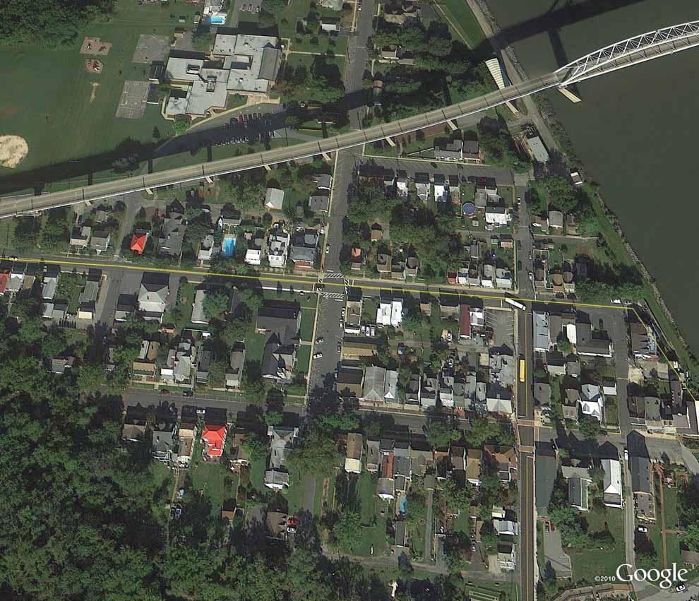
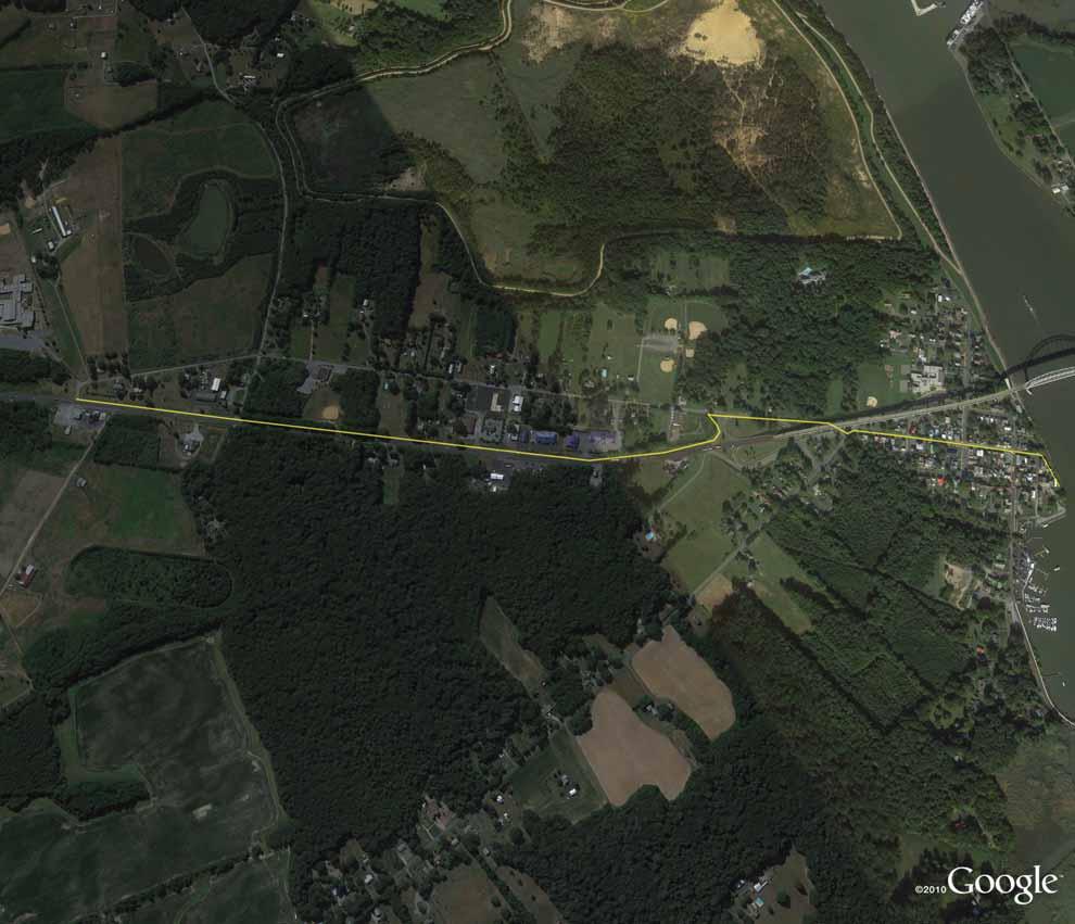
7 Any environmental mitigation activity, including pollution prevention and pollution abatement activities and mitigation to: - address stormwater management, control, and water pollution prevention or abatement related to highway construction or due to highway runoff, including activities described in sections 133(b)(11), 328(a), and 329 of title 23 - reduce vehicle-caused wildlife mortality or to restore and maintain connectivity among terrestrial or aquatic habitats X Safe Routes to School Program, for projects within approximately two miles of a school for kindergarten through eighth grade. X Infrastructure-related projects including planning, design, and construction of infrastructure-related projects on any public road or any bicycle or pedestrian pathway or trail in the vicinity of schools that will substantially improve the ability of students to walk and bicycle to school, including sidewalk improvements, on-street bicycle facilities, off-street bicycle and pedestrian facilities, secure bicycle parking facilities, and traffic diversion improvements in the vicinity of schools. Noninfrastructure activities to encourage walking and bicycling to school, including public awareness campaigns and outreach to press and community leaders, traffic education and enforcement in the vicinity of schools, student sessions on bicycle and pedestrian safety, health, and environment, and funding for training, volunteers, and managers of safe routes to school programs. Safe routes to School coordinator Planning, designing, or constructing boulevards and other roadways largely in the right-of-way of former Interstate System routes or other divided highways. The recreational trails program Primary category of eligibility: Category 1 construction, planning, and design of on-road and off-road trail facilities for pedestrians, bicyclists, and other forms of non-motorized transportation. PROJECT DESCRIPTION (please attach map and/or other supporting information): At nearly 8,000 linear feet, Bohemia Trail will be the main spine of the off-road shared-use trail system on the south side of Chesapeake City. The northern terminus of Bohemia Trail will be at the Town of Chesapeake City s municipal dock on Back Creek Mooring Basin, which is where the (privately funded) ferry boat will load/unload pedestrians and bicyclists. From the municipal dock Bohemia Trail will run west along the C&D Canal up to the George Street overlook. From the overlook, Bohemia Trail will extend south primarily along the west side of George Street until just past First Street where it will crossover to the east side. Bohemia Trail will then follow the west side of George Street south to the crossover at Pine Street. From here, Bohemia Trail will follow along the west side of George Street until the crossover under the Chesapeake City Bridge prior to the intersection with Basil Avenue. The trail will then follow along the west side of Basil Avenue until just after Route 213/Ches. City Bridge on/off ramps where it will cross Basil Avenue and then parallel Rte. 213 (west side of the road) all the way to the Bohemia Manor School Complex entrance off of Basil Avenue. Please see the attached map showing the location of the proposed Bohemia Trail as well as a map showing the Town s entire planned shared-use trail system. 2
8 Who will maintain the project? What will need to be maintained in the short and long term, and what institution will be responsible for doing so? How does the applicant plan to provide for ongoing maintenance costs? The Town of Chesapeake City will be responsible for the ongoing maintenance of Bohemia Trail. Specifically, the Town s Project Manager and maintenance staff will handle the day to day operations and maintenance. Once construction is complete, the short-term maintenance requirements will be mowing, weeding, and trash pickup while the long-term maintenance requirements will include additional tasks such as surface repairs/resurfacing, board/decking replacement (along boardwalk section), repainting of crosswalks, etc. Funding for the maintenance of Bohemia Trail will come from the Town s general fund. FUNDING: Please describe the amount of TAP and matching funds for each phase for which you are seeking funding. Funds are for small projects only, and sponsors must be able to provide a minimum of 20 percent funding match. Funds available for eligible projects on a reimbursement basis administered through the state Departments of Transportation; these funds are not administered as grants. Phase: Concept Plan Funding Amount Phase: Project Development Funding Amount $1,354, Town - Cash $341, Town - Soft $3, Phase: Project Development Funding Amount Yes No Will this amount complete the project? X If no, will this amount complete an independent/stand-alone phase of the project? If this request is not fully funded, do you have other funds to complete the project/phase? X 3
9
10
11 WILMAPCO's TRANSPORTATION ALTERNATIVES PROGRAM (TAP) APPLICATION The Transportation Alternatives Program (TAP), authorized under MAP-21, provides funding for programs and small projects defined as transportation alternatives, including on- and off road pedestrian and bicycle facilities, infrastructure projects for improving non-driver access to public transportation and enhanced mobility, community improvement activities, and environmental mitigation; recreational trail program projects; safe routes to school projects; and projects for the planning, design or construction of boulevards and other roadways largely in the right-of-way of former Interstate System routes or other divided highways. Sponsors must be able to provide a minimum of 20 percent funding match. Project submissions will be evaluated using WILMAPCO s project prioritization process, and other factors as determined by Council. For information about Delaware s program, phone or Jeff.Niezgoda@state.de.us, and Maryland s program, phone or jsilwick@sha.state.md.us. SPONSOR: Eligible sponsors include local governments, transit, natural resource or public land agencies, and education agencies/schools. Nonprofits are not eligible as direct recipients, but may partner as secondary sponsors with any eligible entity. Contact Name and Title: Jeanne D. Minner, Director of Planning Organization: Town of Elkton Address: 100 Railroad Avenue City: Elkton State: MD Zip: Phone: 410/ Jeanne.minner@elkton.org Secondary Sponsor Organization (if applicable): N/A ELIGIBILITY: For details about eligibility, please visit All projects must have a relationship to surface transportation and must be dedicated to public use. The project must fit into at least one of the activities listed below. Indicate which eligible activities the project will achieve (check all that apply): Transportation Alternatives Construct, plan, and design on-road and off-road trail facilities for pedestrians, bicyclists and other nonmotorized transportation, including sidewalks, bicycle infrastructure, pedestrian and bicycle signals, traffic calming techniques, lighting and other safety-related infrastructure, and transportation projects to achieve ADA compliance. Construct, plan, and design infrastructure-related projects and systems that will provide safe routes for non-drivers, including children, older adults, and individuals with disabilities to access daily needs. Convert and use abandoned railroad corridors for trails for nonmotorized transportation. Construct turnouts, overlooks, and viewing areas Community improvement activities, including: - inventory, control, or removal of outdoor advertising - historic preservation and rehabilitation of historic transportation facilities - vegetation management practices in transportation rights-of-way to improve roadway safety, prevent against invasive species, and provide erosion control - archaeological activities relating to impacts from implementation of a transportation project eligible under title 23 MD Transportation Alternatives Program Manual Application A-1
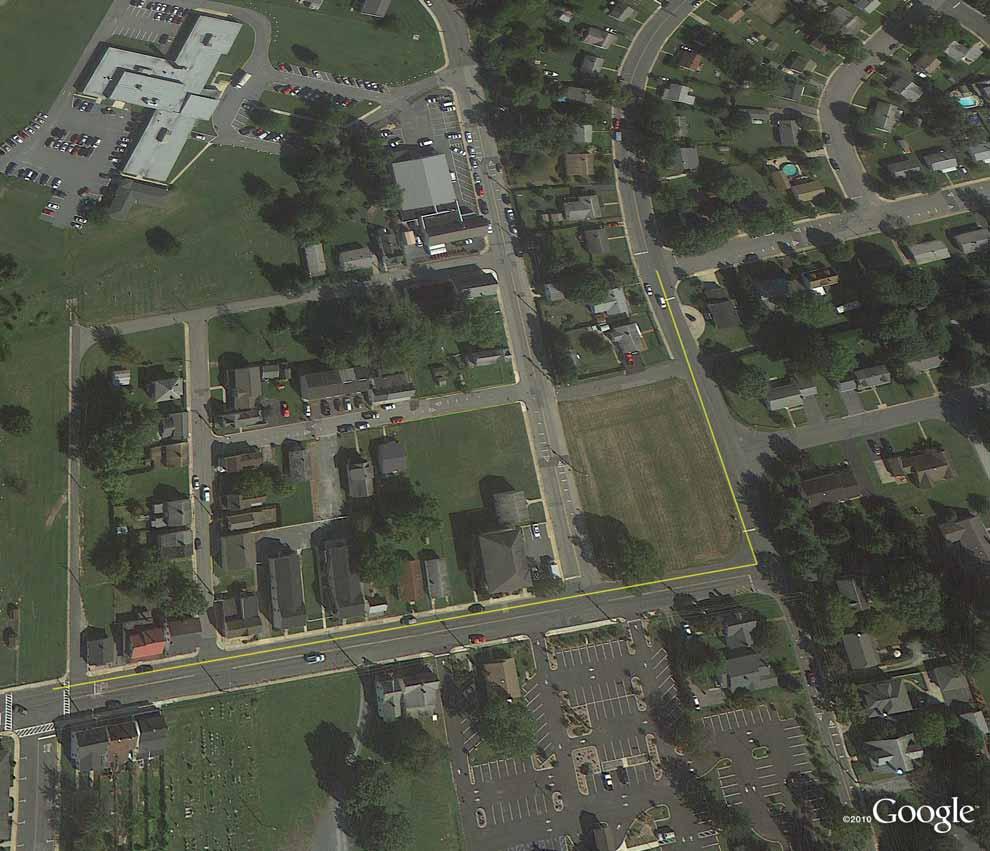
12 Any environmental mitigation activity, including pollution prevention and pollution abatement activities and mitigation to: - address stormwater management, control, and water pollution prevention or abatement related to highway construction or due to highway runoff, including activities described in sections 133(b)(11), 328(a), and 329 of title 23 - reduce vehicle-caused wildlife mortality or to restore and maintain connectivity among terrestrial or aquatic habitats Safe Routes to School Program, for projects within approximately two miles of a school for kindergarten through eighth grade. Infrastructure-related projects including planning, design, and construction of infrastructure-related projects on any public road or any bicycle or pedestrian pathway or trail in the vicinity of schools that will substantially improve the ability of students to walk and bicycle to school, including sidewalk improvements, on-street bicycle facilities, off-street bicycle and pedestrian facilities, secure bicycle parking facilities, and traffic diversion improvements in the vicinity of schools. Noninfrastructure activities to encourage walking and bicycling to school, including public awareness campaigns and outreach to press and community leaders, traffic education and enforcement in the vicinity of schools, student sessions on bicycle and pedestrian safety, health, and environment, and funding for training, volunteers, and managers of safe routes to school programs. Safe routes to School coordinator Planning, designing, or constructing boulevards and other roadways largely in the right-of-way of former Interstate System routes or other divided highways. The recreational trails program Primary category of eligibility: Transportation Alternatives: Plan, design and construct sidewalk facilities for pedestrians to achieve ADA compliance. PROJECT DESCRIPTION (please attach map and/or other supporting information): This project is for preliminary engineering and construction of ADA compliant sidewalks on East High Street between South Street and Locust Lane, and on Locust Lane between East High Street and Booth Lane. This project will benefit residents of an Environmental Justice area (concentrated population of minority/low income residents) and Transportation Justice area (concentrated population of disabled/zero-car household/elderly residents). This project will complete needed sidewalk improvements on East High Street and provide pedestrian access and connectivity to adjacent neighborhoods. (See attached map) MD Transportation Alternatives Program Manual Application A-2
13 Who will maintain the project? What will need to be maintained in the short and long term, and what institution will be responsible for doing so? How does the applicant plan to provide for ongoing maintenance costs? The Town of Elkton will maintain the project for both the short- and long-term. Elkton will provide for ongoing maintenance costs through their General Fund. FUNDING: Please describe the amount of TAP and matching funds for each phase for which you are seeking funding. Funds are for small projects only, and sponsors must be able to provide a minimum of 20 percent funding match. Funds available for eligible projects on a reimbursement basis administered through the state Departments of Transportation; these funds are not administered as grants. Phase: Concept Plan Funding Amount Town of Elkton $1, $ Phase: Project Development Funding Amount Town of Elkton $5, $1, Phase: Construction Funding Amount Town of Elkton $57, $14, Yes No Will this amount complete the project? If no, will this amount complete an independent/stand-alone phase of the project? If this request is not fully funded, do you have other funds to complete the project/phase? MD Transportation Alternatives Program Manual Application A-3
14
15 WILMAPCO's TRANSPORTATION ALTERNATIVES PROGRAM (TAP) APPLICATION The Transportation Alternatives Program (TAP), authorized under MAP-21, provides funding for programs and small projects defined as transportation alternatives, including on- and off road pedestrian and bicycle facilities, infrastructure projects for improving non-driver access to public transportation and enhanced mobility, community improvement activities, and environmental mitigation; recreational trail program projects; safe routes to school projects; and projects for the planning, design or construction of boulevards and other roadways largely in the right-of-way of former Interstate System routes or other divided highways. Sponsors must be able to provide a minimum of 20 percent funding match. Project submissions will be evaluated using WILMAPCO s project prioritization process, and other factors as determined by Council. For information about Delaware s program, phone or Jeff.Niezgoda@state.de.us, and Maryland s program, phone or jsilwick@sha.state.md.us. SPONSOR: Eligible sponsors include local governments, transit, natural resource or public land agencies, and education agencies/schools. Nonprofits are not eligible as direct recipients, but may partner as secondary sponsors with any eligible entity. Contact Name and Title: Joshua Thompson Organization: Sassafras River Association Address: PO Box 333 City: Georgetown State: MD Zip: Phone: jthompson@sassafrasriver.org Secondary Sponsor Organization (if applicable): Cecil County Department of Public Works ELIGIBILITY: For details about eligibility, please visit All projects must have a relationship to surface transportation and must be dedicated to public use. The project must fit into at least one of the activities listed below. Indicate which eligible activities the project will achieve (check all that apply): Transportation Alternatives Construct, plan, and design on-road and off-road trail facilities for pedestrians, bicyclists and other nonmotorized transportation, including sidewalks, bicycle infrastructure, pedestrian and bicycle signals, traffic calming techniques, lighting and other safety-related infrastructure, and transportation projects to achieve ADA compliance. Construct, plan, and design infrastructure-related projects and systems that will provide safe routes for non-drivers, including children, older adults, and individuals with disabilities to access daily needs. Convert and use abandoned railroad corridors for trails for nonmotorized transportation. Construct turnouts, overlooks, and viewing areas Community improvement activities, including: - inventory, control, or removal of outdoor advertising - historic preservation and rehabilitation of historic transportation facilities - vegetation management practices in transportation rights-of-way to improve roadway safety, prevent against invasive species, and provide erosion control - archaeological activities relating to impacts from implementation of a transportation project eligible under title 23 MD Transportation Alternatives Program Manual Application A-1
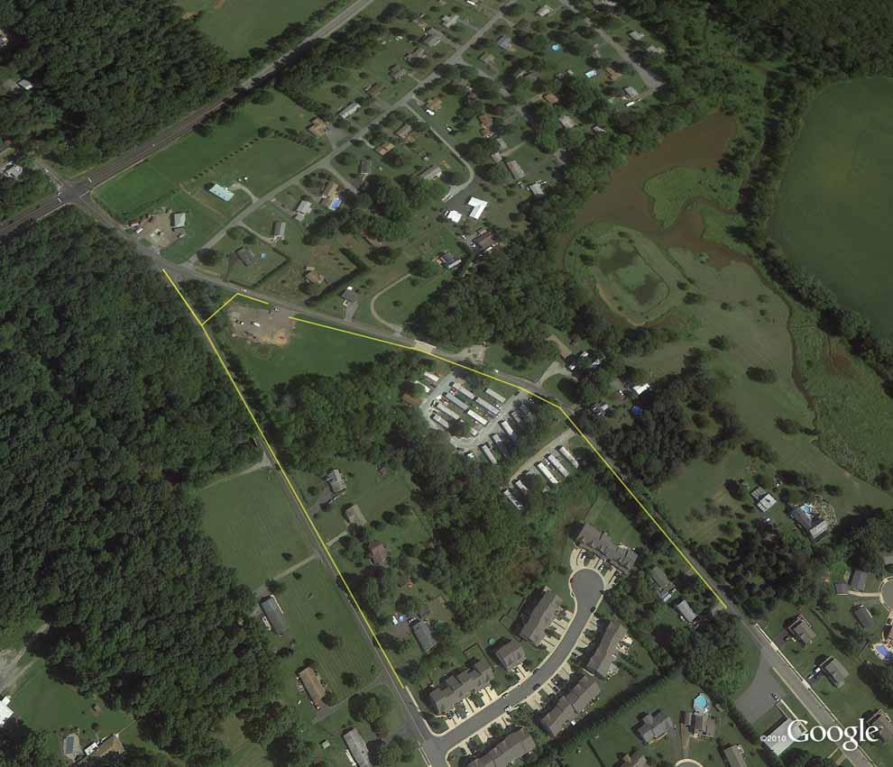
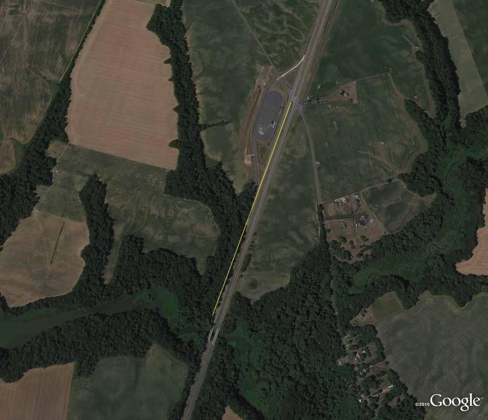
16 Any environmental mitigation activity, including pollution prevention and pollution abatement activities and mitigation to: - address stormwater management, control, and water pollution prevention or abatement related to highway construction or due to highway runoff, including activities described in sections 133(b)(11), 328(a), and 329 of title 23 - reduce vehicle-caused wildlife mortality or to restore and maintain connectivity among terrestrial or aquatic habitats Safe Routes to School Program, for projects within approximately two miles of a school for kindergarten through eighth grade. Infrastructure-related projects including planning, design, and construction of infrastructure-related projects on any public road or any bicycle or pedestrian pathway or trail in the vicinity of schools that will substantially improve the ability of students to walk and bicycle to school, including sidewalk improvements, on-street bicycle facilities, off-street bicycle and pedestrian facilities, secure bicycle parking facilities, and traffic diversion improvements in the vicinity of schools. Noninfrastructure activities to encourage walking and bicycling to school, including public awareness campaigns and outreach to press and community leaders, traffic education and enforcement in the vicinity of schools, student sessions on bicycle and pedestrian safety, health, and environment, and funding for training, volunteers, and managers of safe routes to school programs. Safe routes to School coordinator Planning, designing, or constructing boulevards and other roadways largely in the right-of-way of former Interstate System routes or other divided highways. The recreational trails program Primary category of eligibility: Environmental mitigation to address water pollution due to highway runoff or to reduce vehicle-caused wildlife mortality while maintaining habitat connectivity PROJECT DESCRIPTION (please attach map and/or other supporting information): Project involves restoration of +/- 1,600 linear feet of Sassafras River tributary stream channels. Runoff source control of bioswales and step pools are proposed along Route 301 and at the tributary headwater areas. Bioretention measures will also be installed above the restoration in order to filter and infiltrate excessive stormwater originating from the highway and the Hwy 301 weigh station. Eroded stream sections are proposed to be stabilized using rock and log vanes with bankfull benches created. Structures will be set to encourage the overly widened stream to return to its correct width and allow transport of sediment to prevent embedding of substrate. Regraded banks will stabilized with coir matting and live stakes. All project areas will be planted with native species. Drop inlet structures with downslope bioretention step pools are also proposed for agricultural erosion on the opposite side of the stream/ravine. MD Transportation Alternatives Program Manual Application A-2
17 Who will maintain the project? What will need to be maintained in the short and long term, and what institution will be responsible for doing so? How does the applicant plan to provide for ongoing maintenance costs? The Sassafras River Association volunteer restoration crew will maintain the project within the project footprint located on private land. The project components located within State Highway right-of-way will not require maintenance. SRA holds a fifteen year maintenance easement for access with the private landowner. Maintenance activities will include: periodic removal of woody debris from bioretention pools; removal and replacement of dead or dying plant material; visual check of structures after major storm events; monitoring and control of invasive species within project footprint. FUNDING: Please describe the amount of TAP and matching funds for each phase for which you are seeking funding. Funds are for small projects only, and sponsors must be able to provide a minimum of 20 percent funding match. Funds available for eligible projects on a reimbursement basis administered through the state Departments of Transportation; these funds are not administered as grants. Phase: Concept Plan Funding Amount $0.00 Phase: Project Development Funding Amount 2013 Chesapeake and Atlantic Coastal Bays TF $0.00 $70, Phase: Construction Funding Amount 2013 Chesapeake and Atlantic Coastal Bays TF $440, $370, Yes No Will this amount complete the project? If no, will this amount complete an independent/stand-alone phase of the project? If this request is not fully funded, do you have other funds to complete the project/phase? MD Transportation Alternatives Program Manual Application A-3
18

19 PROJECT PRIORITIZATION TRANSPORTATION ALTERNATIVES PROGRAM The Transportation Alternatives Program (TAP) provides federal funding for on- and off-road pedestrian and bicycle facilities, improvements for non-driver access to public transportation, environmental mitigation, recreational trail program projects, safe routes to school projects, and projects for the planning, design or construction of boulevards and other roadways largely in the right-of-way of former Interstate System routes or other divided highways. A minimum 20% local funding match is required. The TAP is administered in our region by Delaware s Department of Transportation, Maryland's State Highway Administration and the Wilmington Area Planning Council (WILMAPCO). For more information please visit: wilmapco.org/tap. This document is an overview of WILMAPCO s technical process for prioritizing TAP project submissions for funding. The process is open, transparent, and, we hope, easy-to-understand. MAY 2013
20 PROJECT PRIORITIZATION TRANSPORTATION ALTERNATIVES PROGRAM There are many eligible TAP activities. Due to limited program funding, however, WILMAPCO considers only transportation infrastructure projects. These projects such as sidewalks, streetscaping and bicycle lanes are individually scored on a 19 criteria index developed by our Nonmotorized Transportation Working Group (NMTWG). The criteria awards points on a proposed project s proximity to pedestrian and bicycle generating activities, its support for redevelopment, social equity and overall potential use. Criteria are mostly quantitative, though a few measures are judged qualitatively. Projects can receive up to 36 points, with factors such as safety (5 possible points), bus stop proximity (4 possible points) and filling a gap in the nonmotorized system (4 possible points) the heaviest factors. Proposed projects are given a final technical score, which is reviewed by the NMTWG and Technical Advisory Committee (TAC). The proposed project list is then sorted by technical score, and placed before the WILMAPCO Council. The Council ranks the proposed projects with input from the TAC, considering their technical score, cost-effectiveness, and other factors. The remainder of this document provides an overview of each of the technical criteria, and the points associated with it, in turn. REVIEW OF TECHNICAL SCORING INDEX Bus stops The project is located in close proximity to an existing bus stop. 2 within.125 mile 1 within.25 mile The project is located in close proximity to a frequently-used bus stop (New Castle County projects only). 2 within.125 mile 1 within.25 mile 1
21 Community Centers The project is located nearby a community center or post office. 2 within.25 mile 1 within.5 mile Libraries The project is located nearby a library. 2 within.25 mile 1 within.5 mile Schools The project is located nearby an elementary, middle or high school. 2 within.5 mile 1 within 1 mile Parks 2 The project is located alongside a park. Bicycle Routes 2 The project is located on or alongside a designated bicycle route. Greenways The project is located nearby an existing greenway or pathway. 2 within.25 mile 1 within.5 mile Municipalities and Hometown Overlays 1 The project is located within an incorporated municipality, or hometown overlay zone (New Castle County only) 2
22 Population and Employment Density 1 The project is located within a dense ((population + employment) / area) Traffic Analysis Zone. Transportation Equity and Access The project is located within an Environmental Justice (EJ) or Transportation Justice (TJ) neighborhood. EJ areas represent concentrations of low-income and minorities, while TJ areas are home to concentrations of elderly, disabled and zero-car households. 2 within significant EJ area 1 within moderate EJ area 2 within significant TJ area 1 within moderate TJ area Safety The project is located along a road segment with pedestrian and bicycle crashes during the past three years of data. Projects may receive a maximum of 5 points, based on this sub-index: 3 pedestrian or bicycle fatality 2 pedestrian or bicycle injury 1 pedestrian or bicycle crash Abandoned Railway Corridor 1 The project is located along an abandoned railway corridor. Historic Element 1 The project boasts an historic element, expressed within the submission. Nonmotorized Gap Analysis 4 The project closes a pedestrian or bicycle system gap, such as connecting two existing pathways. 3
Introduction.
 2307-1.0. Introduction. Delaware s Safe Routes to School (SRTS) Program was established September 10, 2002 when Governor Ruth Ann Minner signed Senate Bill 353 of the 141st General Assembly of Delaware
Transportation Enhancements, Safe Routes to School, and Recreational Trails to Transportation Alternatives. Pamela Liston, October 30 th, 2013
 Transportation Enhancements, Safe Routes to School, and Recreational Trails to Transportation Alternatives Pamela Liston, October 30 th, 2013 Transportation Alternatives Program These projects are intended
A Matter of Fairness: ROCOG s Environmental Justice Protocol. What is Mobility Limitation?
 No Person Left Behind What is Mobility Limitation? What is the Access Limitation? Environmental Justice population should be provided adequate mobility & access to meet their needs; Identify acceptable
FY 2015 Transportation Alternatives Program
 FY 2015 Transportation Alternatives Program Background The Transportation Alternatives Program (TAP) was authorized under Section 1122 of Moving Ahead for Progress in the 21st Century Act (MAP 21) and
Living Streets Policy
 Living Streets Policy Introduction Living streets balance the needs of motorists, bicyclists, pedestrians and transit riders in ways that promote safety and convenience, enhance community identity, create
ACTIVE TRANSPORTATION
 ACTIVE TRANSPORTATION Mobility 2040 Supported Goals Improve the availability of transportation options for people and goods. Support travel efficiency measures and system enhancements targeted at congestion
Perryville TOD and Greenway Plan
 Perryville TOD and Greenway Plan Greenway Glossary Pathway: A bicycle and pedestrian path separated from motorized vehicular traffic by an open space, barrier or curb. Multi-use paths may be within the
Pedestrian, Bicycle and Traffic Calming Strategic Implementation Plan. January 18, 2011
 Pedestrian, Bicycle and Traffic Calming Strategic Implementation Plan January 18, 2011 Tonight s Agenda Receive update on project Provide feedback on two policy issues Complete Streets Policy Project Prioritization
APPENDIX A: Complete Streets Checklist DRAFT NOVEMBER 2016
 APPENDIX A: Complete Streets Checklist DRAFT NOVEMBER 2016 Complete Streets Checklist MetroPlan Orlando s Complete Streets Checklist is an internal planning tool for staff to further implementation of
HARRISON STREET/OAKLAND AVENUE COMMUNITY TRANSPORTATION PLAN
 HARRISON STREET/OAKLAND AVENUE Community Workshop #4: Draft Plan Review December 3, 2009 D E S I G N, C O M M U N I T Y & E N V I R O N M E N T INTRODUCTIONS Key Project Staff: Alisa Shen, Project Manager,
Non-Motorized Transportation 7-1
 Non-Motorized Transportation 7-1 Transportation facilities no longer mean just accommodating a vehicle powered by a combustion engine. Pedestrian and non-motorized facilities are important modes of travel
Stakeholder Update. Agenda. Project update Needs Identification Strategy Proposed needs Safety Collectors/Arterials Greenways Local roads
 1 Stakeholder Update May 21, 2018 2 Agenda Project update Needs Identification Strategy Proposed needs Safety Collectors/Arterials Greenways Local roads Proposed Evaluation Criteria Next Steps 1 Project/Schedule
Corpus Christi Metropolitan Transportation Plan Fiscal Year Introduction:
 Introduction: The Safe, Accountable, Flexible, Efficient Transportation Equity Act: A Legacy for Users (SAFETEA-LU) has continued the efforts started through the Intermodal Surface Transportation Efficiency
Chapter 5 Future Transportation
 Chapter 5 Future Transportation The Future Land Use Plan identifies the desired land use designations. The land uses desired for Crozet depend, in large part, on the success of the transportation system,
Pedestrian Project List and Prioritization
 To: Kyle Wagenschutz, City of Memphis CC: From: Anne Conlon and John Cock, Alta Planning + Design Date: December, 2014 Re: Project List Development (Task 3.1-3.2) and Project List Prioritization (Task
2018 Transportation Alternatives Program (TAP) Application Presentation to Palm Beach TPA BRANT BRIDGE CONNECTION LOOP EXTENSION ON CARL BOLTER DR
 Application Presentation to Palm Beach TPA BRANT BRIDGE CONNECTION LOOP EXTENSION ON CARL BOLTER DR") 2018 Transportation Alternatives Program (TAP) Application Presentation to Palm Beach TPA BRANT BRIDGE CONNECTION LOOP EXTENSION ON CARL BOLTER DR Project Location N N Connecting South Delray Beach Existing
2018 Transportation Alternatives Program (TAP) Application Presentation to Palm Beach TPA BRANT BRIDGE CONNECTION LOOP EXTENSION ON CARL BOLTER DR Project Location N N Connecting South Delray Beach Existing
City of Novi Non-Motorized Master Plan 2011 Executive Summary
 City of Novi Non-Motorized Master Plan 2011 Executive Summary Prepared by: February 28, 2011 Why Plan? Encouraging healthy, active lifestyles through pathway and sidewalk connectivity has been a focus
Chapter 5. Complete Streets and Walkable Communities.
 Chapter 5. Complete Streets and Walkable Communities. 5.1 Description of Complete Streets. Cities throughout the world, and specifically the United States, are coming to embrace a new transportation and
Transportation Alternatives Set-Aside Program. June 28, 2017
 Transportation Alternatives Set-Aside Program June 28, 2017 What is Transportation Alternatives Set- Aside Program (TASA)? Enhancement program (combined separated programs; old TAP) Not a grant program
Agenda. Overview PRINCE GEORGE S PLAZA METRO AREA PEDESTRIAN PLAN
 PRINCE GEORGE S PLAZA METRO AREA PEDESTRIAN PLAN May 28, 2008 Agenda Welcome and introductions Project overview and issue identification Planning context and strengths Design challenges and initial recommendations
BIKE PLAN CONTENTS GATEWAY
 CONTENTS Acknowledgments...vii Great Rivers Greenway District Board of Directors... vii Great Rivers Greenway District Staff... vii Project Consultants... vii Committees... viii Citizens Advisory Committee
CITY OF COCOA BEACH 2025 COMPREHENSIVE PLAN. Section VIII Mobility Element Goals, Objectives, and Policies
 CITY OF COCOA BEACH 2025 COMPREHENSIVE PLAN Section VIII Mobility Element Goals, Objectives, and Policies Adopted August 6, 2015 by Ordinance No. 1591 VIII MOBILITY ELEMENT Table of Contents Page Number
AGENDA ITEM NO. 5b HCAOG TAC meeting of May 8, 2014
 Humboldt County Association of Governments Eureka, CA, 95501 AGENDA ITEM NO. 5b HCAOG TAC meeting of May 8, 2014 DATE: May 1, 2014 TO: HCAOG Technical Advisory Committee (TAC) FROM:, SUBJECT: Letters of
Introduction. Who is WILMAPCO. Why are walkable communities important
 Walkable Community Workshops Round 1 April 2005 SPONSORED BY WILMAPCO AND CCOBH CITY OF NEW CASTLE EDGEMOOR GARDENS CIVIC ASSOCIATION WITH FUNDING BY DELAWARE DEPARTMENT OF TRANSPORTATION AND THE DELAWARE
Roosevelt Estates Neighborhood Improvements
 Roosevelt Estates Neighborhood Improvements Transportation Alternatives Application May 5 th, 2016 Qualifying Activities Construction of on-road and off-road trail facilities for pedestrians, bicyclists,
Castro Valley Municipal Advisory Council March 19, 2018
 Castro Valley Municipal Advisory Council March 19, 2018 1 Background 2 Draft Bicycle Vision and Pedestrian Networks 3 Next Steps 4 Updates Agenda 2 PROJECT AREA: Unincorporated Areas of Alameda County
Transportation Alternatives Program. FY2017 Applicant Workshop
 FY2017 Applicant Workshop Workshop Overview TAP Basics MAP-21 Legislation Population Areas Sub-Allocation of Funds Local Match Requirements Program Eligibility Eligible Sponsors Transportation Alternatives
RESOLUTION NO ?? A RESOLUTION OF THE CITY OF NEPTUNE BEACH ADOPTING A COMPLETE STREETS POLICY
 RESOLUTION NO. 2018-?? A RESOLUTION OF THE CITY OF NEPTUNE BEACH ADOPTING A COMPLETE STREETS POLICY WHEREAS, safe, convenient, and accessible transportation for all users is a priority of the City of Neptune
Proposed. City of Grand Junction Complete Streets Policy. Exhibit 10
 Proposed City of Grand Junction Complete Streets Policy Exhibit 10 1 City of Grand Junction Complete Streets Policy Vision: The Complete Streets Vision is to develop a safe, efficient, and reliable travel
Watertown Complete Streets Prioritization Plan. Public Meeting #1 December 14, 2017
 Watertown Complete Streets Prioritization Plan Public Meeting #1 December 14, 2017 Goals for Public Meeting Overview of MassDOT Complete Streets Funding Program Educate the community on Complete Streets
ADA Transition Plan. City of Gainesville FY19-FY28. Date: November 5, Prepared by: City Of Gainesville Department of Mobility
 ADA Transition Plan FY19-FY28 Date: November 5, 2018 Prepared by: City Of Gainesville Department of Mobility 1.0 INTRODUCTION 1.1 BACKGROUND The federal statute known as the Americans with Disabilities
MCTC 2018 RTP SCS and Madera County RIFP Multi-Modal Project Eval Criteria GV13.xlsx
 MCTC 8 RTP SCS and Madera County RIFP Multi-Modal Project Eval Criteria GV.xlsx Madera County Transportation Commission Regional Transportation Plan / Sustainable Communities Strategy Multi-Modal Project
MASTER BICYCLE AND PEDESTRIAN PLAN
 VILLAGE OF NORTHBROOK MASTER BICYCLE AND PEDESTRIAN PLAN DRAFT PLAN OPEN HOUSE May 2, 2018 AGENDA 1. Community Engagement 2. Vision and Goals 3. General Structure of Plan 4. Recommendations Overview 5.
Safe Routes to School Action Plan Aberdeen, Idaho
 Background Aberdeen, Idaho is a largely agricultural community of nearly 2,000 people and is located in the southeast portion of the state on the western edge of American Falls Reservoir. The community
Chapter 13 ORANGE COVE
 Chapter 13 ORANGE COVE This chapter describes the current status and future plans for biking and walking in the City of Orange Cove. RELATIONSHIP TO CITY PLANS AND POLICIES The Orange Cove General Plan
NJDOT Complete Streets Checklist
 Background The New Jersey Department of Transportation s Complete Streets Policy promotes a comprehensive, integrated, connected multi-modal network by providing connections to bicycling and walking trip
Cecil County, Maryland. Bicycle Master Plan
 Cecil County, Maryland Bicycle Master Plan Overview Background Schedule and Tasks Network Assessment Network Identification Next Steps Schedule and Tasks May 2011 Plan Scoping and Mobilization Data Collection
TOWN OF WILLIAMSTON, SC BICYCLE AND PEDESTRIAN MASTER PLAN TOWN OF WILLIAMSTON, SC BICYCLE AND PEDESTRIAN MASTER PLAN
 TOWN OF WILLIAMSTON, SC BICYCLE AND PEDESTRIAN MASTER PLAN Americans Want Choices 55% of Americans would rather drive less & walk more. Transit use is growing faster than population or highway travel.
City of Sammamish. Welcome. Issaquah-Fall City Road Improvements Project Phase I Design: 242nd Avenue SE to Klahanie Drive SE
 Welcome Welcome to the third community meeting for the Issaquah-Fall City Road Improvements Project. AGENDA 6:00 p.m. Welcome and sign-in 6:10 p.m. Presentation 6:50 p.m. Open house Learn about the roadway
The Role of MPOs in Advancing Safe Routes to School through the Transportation Alternatives Program
 The Role of MPOs in Advancing Safe Routes to School through the Transportation Alternatives Program In 2012, Congress made changes to Federal funding for Safe Routes to School that gave some metropolitan
Americans with Disabilities Act Transition Plan for Public Right-of-Way Improvements
 Americans with Disabilities Act Transition Plan for Public Right-of-Way Improvements Prepared by: Public Works Department Engineering Division October 2015 Table of Contents Section I Introduction.. 3
Urbana Pedestrian Master Plan
 Urbana Pedestrian Master Plan Recommendations Gabe Lewis, Transportation Planner Champaign County Regional Planning Commission November 15, 2018 Public Meeting #2 Public Input Round #1 Thank You! 10 public
ROUTE 81 CORRIDOR STUDY DESIGN CONCEPTS
 RT 81 Corridor Study CLINTON ROUTE 81 CORRIDOR STUDY DESIGN CONCEPTS View north on High Street, with potential improvements to the streetscape Draft Recommendations November 8 th, 2018 TOWN OF CLINTON
CITY MANUALS AND STANDARDS REVIEW
 GEORGETOWN SIDEWALK MASTER PLAN CITY MANUALS AND STANDARDS REVIEW RESOURCES AND STANDARDS As part of the Master Plan process, a review and evaluation of current City documents and policies relevant to
Goal 3: Foster an environment of partnerships and collaboration to connect our communities and regions to one another.
 Non-Motorized Transportation Plan (NMTP) Draft Vision, Goal and,, Tri-County Regional Planning Commission (TCRPC) Purpose The purpose of the Tri-County Regional Planning Commission (TCRPC) Non-Motorized
Downtown Naples Mobility and Connectivity Study. Naples City Council Presentation January 2017
 Downtown Naples Mobility and Connectivity Study Naples City Council Presentation January 2017 Agenda 1. Introduction 2. Scope Review 3. Project Schedule 4. Existing Conditions 5. Public Charrette 6. Mobility
Mayor s Bicycle Advisory Council. Wednesday, December 13 th, 2017
 Mayor s Bicycle Advisory Council Wednesday, December 13 th, 2017 Bicyclist Fatalities, Year to Date (January 1 November 30, 2017) - MBAC Briefing Bicyclist Fatality Statistics Year to date total, 2017
Bicycle Master Plan Goals, Strategies, and Policies
 Bicycle Master Plan Goals, Strategies, and Policies Mobilizing 5 This chapter outlines the overarching goals, action statements, and action items Long Beach will take in order to achieve its vision of
SAN FRANCISCO MUNICIPAL TRANSPORTATION AGENCY
 THIS PRINT COVERS CALENDAR ITEM NO. : 10.2 DIVISION: Sustainable Streets BRIEF DESCRIPTION: SAN FRANCISCO MUNICIPAL TRANSPORTATION AGENCY Adopting Conceptual Proposal for Streetscape Improvements to Broadway,
Item to be Addressed Checklist Consideration YES NO N/A Required Description Complete Streets Guidelines
 Passaic County Complete Streets Checklist - Concept Development Project Name Item to be Addressed Checklist Consideration YES NO N/A Required Description Complete Streets Guidelines Existing Plans Have
Chapter 14 PARLIER RELATIONSHIP TO CITY PLANS AND POLICIES. Recommendations to Improve Pedestrian Safety in the City of Parlier (2014)
") Chapter 14 PARLIER This chapter describes the current status and future plans for biking and walking in the City of Parlier. RELATIONSHIP TO CITY PLANS AND POLICIES The Parlier General Plan is the primary
Chapter 14 PARLIER This chapter describes the current status and future plans for biking and walking in the City of Parlier. RELATIONSHIP TO CITY PLANS AND POLICIES The Parlier General Plan is the primary
Tonight is for you. Learn everything you can. Share all your ideas.
 Strathcona Neighbourhood Renewal Draft Concept Design Tonight is for you. Learn everything you can. Share all your ideas. What is Neighbourhood Renewal? Creating a design with you for your neighbourhood.
Ocean Park Boulevard Green Street Project Alternatives & Trade Offs
 Planning Commission March 4, 2009 Ocean Park Boulevard Green Street Project Alternatives & Trade Offs Purpose of Tonight s Meeting Review concept plans and options Provide input on alternatives and trade-offs
42nd Ave N Reconstruction
 CITY OF MINNEAPOLIS 42nd Ave N Reconstruction Community Meeting #2 May 2016 6:00 7:30 p.m. 5/16/2016 1 Purpose of Meeting Inform: Provide an overview of project, identify anticipated scope of work, and
Community Open House December 13, A project of the Green Infrastructure Center, supported by Skeo Solutions
 Community Open House December 13, 2011 A project of the Green Infrastructure Center, supported by Skeo Solutions Project Background The Green Infrastructure Center, Inc. (GIC) was formed in 2006 to help
5. RUNNINGWAY GUIDELINES
 5. RUNNINGWAY GUIDELINES These guidelines should be considered collectively when making runningway decisions. A runningway is the linear component of the transit system that forms the right-of-way reserved
WELCOME TO OPEN HOUSE # 1 June 14, 2017
 Langstaff Road Weston Road to Highway 7 Class Environmental Assessment Study WELCOME TO OPEN HOUSE # 1 June 14, 2017 Please sign in and join our mailing list Purpose of Open House #1 & Study Area York
TRANSPORTATION NEEDS ASSESSMENT
 TRANSPORTATION NEEDS ASSESSMENT A travel demand analysis was carried out to determine the operational issues and the potential benefit that adding traffic capacity would have on the road network. All the
Solana Beach Comprehensive Active Transportation Strategy (CATS)
") Solana Beach Comprehensive Active Transportation Strategy (CATS) 3.0 Goals & Policies The Solana Beach CATS goals and objectives outlined below were largely drawn from the Solana Beach Circulation Element
Solana Beach Comprehensive Active Transportation Strategy (CATS) 3.0 Goals & Policies The Solana Beach CATS goals and objectives outlined below were largely drawn from the Solana Beach Circulation Element
Engineering - Bicycle and Pedestrian
 Capital Improvement Plan Project Summary # Bikeways Program 781,000 860,000 900,000 933,000 933,000 933,000 # Cannonball Path 1,200,000-780,000 - - - # Capital City Trail - 70,000 - - 910,000 - # Goodman
Project Status Update
 Project Status Update : Novato Boulevard, 4th & 3rd Streets, Sir Francis Drake Boulevard (3), and Miller Avenue Major roads projects target the most heavily traveled roads in Marin County for repairs,
City of Elizabeth City Neighborhood Traffic Calming Policy and Guidelines
 City of Elizabeth City Neighborhood Traffic Calming Policy and Guidelines I. Purpose: The City of Elizabeth City is committed to ensure the overall safety and livability of residential neighborhoods. One
REGIONAL BICYCLE AND PEDESTRIAN DESIGN GUIDELINES
 REGIONAL BICYCLE AND PEDESTRIAN DESIGN GUIDELINES November 16, 2011 Deb Humphreys North Central Texas Council of Governments Bicycle and Pedestrian Advisory Committee Snapshot of the Guide 1. Introduction
This page intentionally left blank.
 This page intentionally left blank. COMMUNITY Glenpool Community Overview Glenpool Glenpool is a city of nearly 12,000 residents located in Tulsa County southwest of Tulsa and Jenks. The city is growing
Section 7 Complete Green Street Guidelines DRAFT
 Section 7 Complete Green Street Guidelines DRAFT 1 Section: 7.0 COMPLETE GREEN STREET GUIDELINES These guidelines serve as options to mitigate the environmental impact of a project as well as guide the
City of Moorhead Committee of the Whole Meeting
 City of Moorhead Committee of the Whole Meeting Corridor Study Limits Center Avenue (Red River to 8th Street) TH 10 (Red River to TH 336) TH 75 (20th Ave S to Main Avenue) 2 Study Need: Project Overview
Fitting Light Rail through Well-established Communities
 Fitting Light Rail through Well-established Communities San Francisco 2008 Michael D. Madden Chief, Project Development, Maryland Transit Administration Project Setting Located inside the Capital Beltway
City of Charlottesville Bicycle and Pedestrian Master Plan Update
 City of Charlottesville Bicycle and Pedestrian Master Plan Update September 17, 2014 I. Welcome and meeting overview II. Project status update III. Network overview IV. Break-out groups Pedestrian Network
Bicycle Lanes Planning, Design, Funding South Mountain Partnership Trails Workshop Roy Gothie PennDOT Statewide Bicycle Pedestrian Coordinator
 Bicycle Lanes Planning, Design, Funding 2018 South Mountain Partnership Trails Workshop Roy Gothie PennDOT Statewide Bicycle Pedestrian Coordinator Policy Changes: BOP Bicycle Policy Changes The OLD Way
TOWN OF PORTLAND, CONNECTICUT COMPLETE STREETS POLICY
 TOWN OF PORTLAND, CONNECTICUT COMPLETE STREETS POLICY I. VISION, GOALS & PRINCIPLES VISION To improve the streets of Portland making them safer and more accessible for all users including pedestrians,
Transportation Alternatives Set-Aside FY2018 Applicant Workshop
 Transportation Alternatives Set-Aside FY2018 Applicant Workshop Workshop Overview Transportation Alternatives Basics FAST Act Population Areas Sub-Allocation of Funds Local Match Requirements Program Eligibility
North Shore Transportation Improvement Strategy
 North Shore Transportation Improvement Strategy Preliminary, Near-term Recommendation 2016 April Transportation Improvement Strategy (TIS) Comprehensive and Analytical A multi-modal transportation strategy
5 CIRCULATION AND STREET DESIGN
 5 CIRCULATION AND STREET DESIGN This chapter describes circulation and streetscape improvements proposed for the Northwest Chico Specific Plan Area. It includes detailed design specifications for existing
SNCC Demographic Trends
 Employment Population SNCC Demographic Trends In 1970 the SNCC population was 10,040, accounting for roughly 3% of the County population In 2015, SNCC grew to 60,567 people, roughly 11% of the County population
2015 Florida Main Street Annual Conference. Complete Streets Equal Stronger Main Streets
 WHAT ARE COMPLETE STREETS? CASE STUDIES COMPLETING YOUR MAIN STREET 2015 Florida Main Street Annual Conference St. Petersburg, Florida August 19, 2015 WHAT ARE COMPLETE STREETS? CASE STUDIES COMPLETING
o n - m o t o r i z e d transportation is an overlooked element that can greatly enhance the overall quality of life for the community s residents.
 N o n - m o t o r i z e d transportation is an overlooked element that can greatly enhance the overall quality of life for the community s residents. 84 Transportation CHAPTER 11 INTRODUCTION Transportation
Funding Sources Appendix I. Appendix I. Funding Sources. Virginia Beach Bikeways and Trails Plan 2011 Page I-1
 Funding Sources Virginia Beach Bikeways and Trails Plan 2011 Page I-1 Funding Sources Federal and state agencies provide funding for local bikeway and trail projects. Descriptions follow for programs that
Bicycle and Pedestrian Facilities Toolbox (Excerpt from Figure 3.1)
") Appendix B Neighborhood Connections Summaries This Appendix is a supplement to the information presented in Chapter 3 Connect People. The Appendix includes a summary or profile for each of the proposed
Appendix B Neighborhood Connections Summaries This Appendix is a supplement to the information presented in Chapter 3 Connect People. The Appendix includes a summary or profile for each of the proposed
NM-POLICY 1: Improve service levels, participation, and options for non-motorized transportation modes throughout the County.
 Transportation PRINCE WILLIAM COUNTY 2008 COMPREHENSIVE PLAN NON-MOTORIZED PLAN CONTENTS Goals, Policies, and Action Strategies Table 4 (Bike Facility Classifications and Descriptions) Table 5 (Bike Facility
IMPLEMENTATION STRATEGIES
 GEORGETOWN SIDEWALK MASTER PLAN 34% of funding is dedicated to Downtown Overlay District sidewalks 28% of funding is recommended within 1/4 mile of Southwestern University 26% of funding is recommended
RZC Appendix 8A Marymoor Subarea Street Requirements
 RZC Appendix 8A Marymoor Subarea Street Requirements For additional design details for Marymoor Subarea infrastructure, refer to the 2017 Marymoor Subarea Infrastructure Planning Report. STREET REQUIREMENTS
PEDESTRIAN ACTION PLAN
 ATTACHMENT 2 CITY OF SANTA MONICA PEDESTRIAN ACTION PLAN CITY OF SANTA MONICA PEDESTRIAN ACTION PLAN This page intentionally left blank EXECUTIVE SUMMARY CHAPTER 1 EXECUTIVE SUMMARY Setting the Stage
ADOT Statewide Bicycle and Pedestrian Program Summary of Phase IV Activities APPENDIX B PEDESTRIAN DEMAND INDEX
 ADOT Statewide Bicycle and Pedestrian Program Summary of Activities APPENDIX B PEDESTRIAN DEMAND INDEX May 24, 2009 Pedestrian Demand Index for State Highway Facilities Revised: May 29, 2007 Introduction
MAG Town of Cave Creek Bike Study Task 6 Executive Summary and Regional Significance Report
 Page 1 MAG Town of Cave Creek Bike Study Task 6 Executive Summary and Regional Significance Report August 1, 2012 MAG Project #481 Page 2 Task 6 Executive Summary and Regional Significance Report Introduction
Brooklyn Boulevard (County Road 152) Reconstruction Project Phase I. OPEN HOUSE June 20, 2017
 Reconstruction Project Phase I. OPEN HOUSE June 20, 2017") Brooklyn Boulevard (County Road 152) Reconstruction Project Phase I OPEN HOUSE June 20, 2017 Brooklyn Boulevard (County Road 152) Phase I Project Partners Project Lead Other Project Partners include Brooklyn
Brooklyn Boulevard (County Road 152) Reconstruction Project Phase I OPEN HOUSE June 20, 2017 Brooklyn Boulevard (County Road 152) Phase I Project Partners Project Lead Other Project Partners include Brooklyn
Citywide Sidewalk and Crosswalk Programs
 Citywide Sidewalk and Crosswalk Programs Council Meeting October 20, 2015 Presented by Rita Hu and Jamal Mahmoud Program Goals Implement the City s comprehensive plan. Provide pedestrian with safe walking
Duwamish Way-finding and CTR Report
 V. North Tukwila When the North Tukwila Manufacturing and Industrial Center was designated in 1992 as part of the region s land use and transportation plan, the plan called for the area to set a light-rail
Bar Harbor Route 3 Gateway Project Advisory Committee September 21, 1-3 PM Atlantic Oakes Hotel Minutes
 Bar Harbor Route 3 Gateway Project Advisory Committee September 21, 1-3 PM Atlantic Oakes Hotel Minutes Attending: Dick Cough, Edith Milbury, James Blanchard, Chris Fogg, Paul MacQuinn Millard Billings,
MPO Staff Report Technical Advisory Committee: May 10, 2017 MPO Executive Board: May 17, 2017
 MPO Staff Report Technical Advisory Committee: May 10, 2017 MPO Executive Board: May 17, 2017 RECOMMENDED ACTION: Update on the NDDOT US Business 2 Project Programmed for 2019 Matter of the NDDOT US Business
3.9 Recreational Trails and Natural Areas
 3.9 Recreational Trails and Natural Areas 3.9.1 Introduction Parks and other recreational facilities such as trails, bicycle routes, and open space are important community resources. This section discusses
PRINCE GEORGE S PLAZA METRO AREA PEDESTRIAN PLAN
 PRINCE GEORGE S PLAZA METRO AREA PEDESTRIAN PLAN May 28, 2008 Agenda Welcome and introductions Project overview and issue identification Planning context and strengths Design challenges and initial recommendations
AMENDING MOTION: Mobility Plan - Pedestrians and Disadvantaged Communities
 I MOVE that the Council: AMENDING MOTION: Mobility Plan - Pedestrians and Disadvantaged Communities 1. INSTRUCT the Department of City Planning to amend the proposed Mobility Plan to include the following;
Traffic Calming Policy
 Page 22 of Report TS-1-13 Development and Infrastructure Division Transportation Services Department Approved by: City Council on February 19, 2013 Report Number: TS-1-13 Effective: February 20, 2013 Amended:
West Dimond Blvd Upgrade Jodhpur Street to Sand Lake Road
 West Dimond Blvd Jodhpur St to Sand Lake CSS Transportation Project Summary Municipality of Anchorage Project # 05 005 Project Manager: John Smith, P.E. (MOA PM&E) Project Administrator: Julie Makela,
2018 Pedestrian and Bicycle and Safe Routes to School Application for Funding Page 1 of 31
 2018 Pedestrian and Bicycle and Safe Routes to School Application for Funding Page 1 of 31 2018 Pedestrian and Bicycle and Safe Routes to School Application for Funding Part 1: General Information Funding
SUMMARY OF TRANSPORTATION INVESTMENTS
 Santa Cruz County 2016 Measure D: Transportation Improvement Expenditure Plan - Approved by over 2/3 of Santa Cruz County voters on November 8, 2016 - Overview Measure D, the 2016 Transportation Improvement
CHAPTER 7.0 IMPLEMENTATION
 CHAPTER 7.0 IMPLEMENTATION Achieving the vision of the Better Streets Plan will rely on the ability to effectively fund, build and maintain improvements, and to sustain improvements over time. CHAPTER
Morristown, NJ Complete Streets Policy
 Morristown, NJ Complete Streets Policy Introduction A Complete Street is defined as a means to provide safe access for all users by designing and operating a comprehensive, integrated, connected multi-modal
State Highway 16 Kuna-Mora Road to Ada/Gem County Line
 Background Update! (February 2018): This project has been partially funded; see below. State Highway 16 is the main commuter route from Gem County to the Treasure Valley. An increase in traffic and accidents
CHAPTER 16 PEDESTRIAN FACILITIES DESIGN AND TECHNICAL CRITERIA TABLE OF CONTENTS
 CHAPTER 16 PEDESTRIAN FACILITIES DESIGN AND TECHNICAL CRITERIA TABLE OF CONTENTS Section Title Page 16.1 General... 16-1 16.1.1 AASHTO Reference... 16-1 16.1.2 ADA Requirements... 16-1 16.2 Sidewalks...