Minnesota s Best Practices for Pedestrian/Bicycle Safety
|
|
|
- Annis Hodge
- 6 years ago
- Views:
Transcription


1 Minnesota s Best Practices for Pedestrian/Bicycle Safety REPORT SEPTEMBER 2013 MnDOT Office of Traffic, Safety and Technology 1500 West County Road B2 Mail Stop 725 Roseville, MN Phone: Fax: traffic.dot@state.mn.us
2 Document Information and Disclaimer (1 of 4) The information in this Best Practices Guide is provided as a resource to assist agencies in their effort to more safely accommodate pedestrians and bicyclists on their systems of roads and highways. The information in this handbook is consistent with best practices in safety planning as presented in guidance prepared by the Federal Highway Administration (FHWA), the American Association of State Highway and Transportation Officials (AASHTO), and the National Cooperative Highway Research Program (NCHRP). This information is provided to agencies in an effort to reduce the number of severe crashes with pedestrians and bicyclists on their roadway systems, and it is understood that the final decision to implement any of the strategies resides with the agency. There is no expectation or requirement that agencies implement any specific safety strategies, and it is understood that actual implementation decisions will be made by agency staff based on consideration of safety, economic, social, and political issues and location-specific considerations. This Best Practices Guide should be interpreted as follows: This Best Practices Guide does not set requirements or mandates. This Best Practices Guide contains no warrants or standards and does not supersede other publications that do. This Best Practices Guide is not a standard and is neither intended to be, nor does it establish, a legal standard of care for users or professionals. This Best Practices Guide does not supersede publications such as the following: Minnesota s Manual on Uniform Traffic Control Devices (MUTCD) Association of AASHTO s Green Book: A Policy on Geometric Design of Highways and Streets Other AASHTO and agency guidelines, manuals, and policies The practices in this guide provide an overview of the current general state of the practice in Minnesota relating to the design, and operation of pedestrian- and bicycle-related facilities. However, agencies are encouraged to modify information in this material as necessary to reflect their own experience, culture and practices. Following any implementation or application of the best practices, agencies are encouraged to review, evaluate, and, if necessary, modify practices to make them more consistent with their actual conditions and system needs. Each Best Practice provides the following information: Description and Definition Information on the purpose and description of the strategy Safety Characteristics A summary of the safety benefits of the strategy and any related research or data Proven, Tried, or Experimental A summary of the strategy s crash reductions based on FHWA s Crash Modification Factor (CMF) Clearinghouse ( FHWA s Pedestrian CMF Toolbox ( fhwa.dot.gov/tools/crf/resources/briefs/pedissuebrief.cfm), the NCHRP Report 500, and designation of each of the strategies as one of the following: Proven Strategies have been widely deployed and have been subject to properly designed evaluations that show them to be consistently effective. In an effort to help reduce the potential exposure to claims of negligence associated with motor vehicle crashes on an agency s roadway system, the following two key points should be considered: (1) Minnesota tort law provides for discretionary immunity for decisions made by agency officials when there is documentation of the decision and evidence of consideration of social, economic, and political issues. (2) Minnesota tort law also provides for official immunity for decisions made by agency staff where there is written documentation of the thought process supporting project development and implementation. MINNESOTA S BEST PRACTICES FOR PEDESTRIAN/BICYCLE SAFETY SEPTEMBER 2013 i
3 Document Information and Disclaimer (2 of 4) Tried Strategies have been implemented in a number of locations where the results of the evaluations have not been fully evaluated or are inconsistent. Experimental Strategies are ideas that have been suggested and at least one agency has considered sufficiently promising to try on a small scale in at least one location. Typical Characteristics of Candidate Locations The appropriate use of the strategy based on roadway characteristics Typical Costs A summary of the typical costs for installation of the safety strategies and any applicable maintenance costs based on available past projects Design Features Information on the latest design of the safety strategy and the appropriate design criteria to be used during implementation Best Practice A short summary of the current best practice relating to the safety strategy Sources Related resources and cited materials Pedestrian Safety Strategies Strategies Pages Sidewalks 1-2 Crosswalks and Crosswalk Enhancements Crash Reduction/ Crash Features 50 to 90% reduction in walking in roadway pedestrian crashes Proven/Tried/ Experimental Operational Effects (Mobility) Candidate Locations Proven N/A Urban arterials & collectors 3-8 Varies Proven/Tried N/A Intersections Medians and Crossing Islands to 46% Proven Curb Extensions to 46% Proven Pedestrian Hybrid Beacon System Rectangular Rapid Flashing Beacon % Tried to 100% yield to pedestrian rate Tried Crosswalk Lighting to 44% Proven N/A Traffic Signals Leading Pedestrian Interval 60% Tried May provide operational benefits Potential reduction in speeds Additional delay for vehicles stopping for pedestrians Additional delay for vehicles stopping for pedestrians Increases delay and reduces mobility of major roadway Wide 2-lane roads and multi lane roadways Urban arterials and collectors with curb parking Mid-Block Crosswalk locations Not at intersections Mid-Block Crosswalk Isolated crosswalks not along a continuously lit roadway Intersections that meet signal warrants Design Features Curb ramps, cross slope, buffer zones Should be part of package including crosswalk enhancements 4 to 8 feet wide Roadway with parking or shoulder Pedestrian activated $80,000 Passive or active pedestrian activation Require a power source Short cycle lengths, countdown timers, easy accessibility Construction Costs $4 to $5 per square foot $200 per crosswalk $15,000 to $30,000 per 100 feet $5,000-$10,000 per extension $10K to $15K $10k to $25K per intersection New Signal - $175,000 to more than $300,000 per intersection MINNESOTA S BEST PRACTICES FOR PEDESTRIAN/BICYCLE SAFETY SEPTEMBER 2013 ii
 May provide operational benefits for locations with")
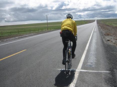
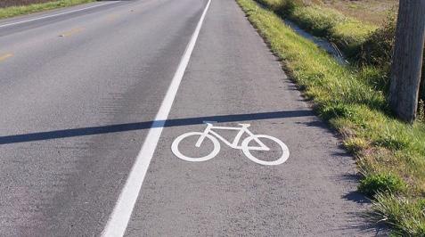
4 Document Information and Disclaimer (3 of 4) Ped and Bicycle Safety Strategies Strategies Pages Grade Separated Crossing Crash Reduction/ Crash Features 80 to 90% in fatal and injury crashes Proven/Tried/ Experimental Proven Crossing Guards NA Tried Shared Space and Complete Streets NA Tried Operational Effects (Mobility) May provide operational benefits for locations with high pedestrian traffic Higher compliance with guard Equal travel speeds for all users Candidate Locations Limited access/high-volume roadways Design Features Install barriers or landscaping to discourage at-grade crossing School crossings Training required NA Low speed/high pedestrian and bicycle volumes Limited or no traffic control devices Construction Costs $500,000 to $4 million NA Road Diet % all crashes (benefits to pedestrians) Proven/Tried Potential speed reduction 4-lane undivided roadways with ADT <20,000 Variations of distribution of cross section available $16,000 per mile for restriping $500,000 for overlay $5 million for reconstruction Bicycle Safety Strategies On-Road Bicycle Lane to +13% Tried NA Urban and suburban 4 to 8 feet wide Shared (Paved) Shoulder Bicycle Lane NA Tried NA Rural roadways 4 to 10 feet wide Bicycle Boulevards % Tried Reduces conflict with vehicles on parallel arterial Local streets Traffic-calming features often used $16,000 per mile for restriping $60,000 per mile for 4-foot shoulders $100,000 per mile for 8-foot shoulders Minimal Signs and Markings Bicycle Boxes NA Experimental NA Signalized intersections 14-foot-wide rectangle $1,000 per box (see page 7 for information on pavement marking life cycles) MINNESOTA S BEST PRACTICES FOR PEDESTRIAN/BICYCLE SAFETY SEPTEMBER 2013 iii
5 Document Information and Disclaimer (4 of 4) Pedestrian and Bicycle Considerations Strategies Pages Roundabouts Bicycle-friendly Edgeline Rumbles Speed Reduction Measures Crash Reduction/ Crash Features Lower speeds and medians for pedestrian refuge 30 35% of Road Departure Crashes Low-speed roads have higher crash rates and higher fraction of pedestrian crashes Proven/Tried/ Experimental Proven Vehicles Tried Pedestrians Proven Tried Operational Effects (Mobility) Slows traffic entering roundabout N/A Limited reduction of speed without changing driver s perceptions of roadway Candidate Locations Arterials and major collectors Lower volume rural roadways School zones, speed transitions Design Features Splitter islands help pedestrians by separating entering and exiting traffic 48-foot strip with 12 foot gap Road diets, curb extensions and streetscaping help change driver s perceptions Construction Costs more than $1,000,000 $3,000 per mile Varies by strategy $250 to more than $1,000,000 ACKNOWLEDGEMENTS Thank you to the following sponsors and participants for their valuable input in the production of this document: Technical Advisory Committee Members Monica Beeman City of St. Paul Lisa Bender MnDOT Sulmaan Khan MnDOT Brad Estochen MnDOT Danny McCullough Three Rivers Park District Jim Grothaus University of Minnesota Kate Miner Carver County Joe Gustafson Washington County Mark Vizecky MnDOT Jeff Holstein City of Brooklyn Park Richard West Ottertail County Funding Sponsors Minnesota Local Road Research Board Minnesota Department of Transportation (MnDOT) Writing Howard Preston and Nikki Farrington, CH2M HILL Charles Zegeer, Director, Pedestrian and Bicycle Information Center, University of North Carolina Highway Safety Research Center Graphic Design Chrissy Ehlers, CH2M HILL Editor Rebecca Schlei, CH2M HILL The contents of this handbook reflect the views of the authors who are responsible for facts and accuracy of the data presented. The contents do not necessarily reflect the views or policies of the Local Road Research Board or the Minnesota Department of Transportation at the time of publication. This handbook does not constitute a standard, specification, or regulation. MINNESOTA S BEST PRACTICES FOR PEDESTRIAN/BICYCLE SAFETY SEPTEMBER 2013 iv

6 Rural Lighting Sidewalks Policy (2 of 2) (1 of 2) PEDESTRIAN SAFETY STRATEGIES Walking along the roadway is a pedestrian crash risk (that is, the probability of a pedestrian being struck is higher if a sidewalk is not present.) Research has found an 88 percent reduction in walking along the roadway pedestrian crashes with the installation of sidewalk and/or walkways on both sides of the road (McMahon, et. al.). TYPICAL CHARACTERISTICS OF CANDIDATE LOCATIONS Source: / Dan Burden DESCRIPTION AND DEFINITION A sidewalk is a path for pedestrian travel placed along the side of a roadway, usually separated from roadway traffic lanes by curb and gutter and sometimes by a planting strip or buffer zone. SAFETY CHARACTERISTICS The safety benefits of sidewalks come from the ability to provide pedestrians with their own travel space that is separated from the traffic on a roadway (FHWA RD ). PROVEN, TRIED, OR EXPERIMENTAL Sidewalks are a PROVEN safety strategy. Sidewalks on both sides of a street have been found to significantly reduce occurrences of walking along the roadway compared to locations where no sidewalks or walkways exist. The effort of planning for a network of sidewalks should include an audit of the current sidewalk system. The audit should document the accessibility of transit stops/service, schools, public buildings, and parks, etc., to pedestrians and should include consideration of sidewalk design issues, including obstructions (e.g., fire hydrants, signposts, etc.) and compliance with Americans with Disabilities Act (ADA) Standards for Accessible Design (see PROWAG guidelines). For safety reasons, sidewalks should be implemented on all urban arterials and collectors, whenever possible. For urban streets without sidewalks or walkways, priorities should be established for adding new sidewalks. For example, higher priorities should be given for sidewalk installation on roads that connect pedestrian origins and destinations (for instance, connecting neighborhoods with schools and shopping areas) and for roads with higher speeds and volumes with priority at locations without shoulders. TYPICAL COSTS Typical costs for implementation of sidewalks vary depending on the location, amount of available right-of-way, and materials used, but are generally in the range of $4 to $5 per square foot for a concrete sidewalk, excluding costs for purchasing additional right-of-way. The cost for adding standard curbs and gutters is approximately $20 to $35 per linear foot, although the costs will vary MINNESOTA S BEST PRACTICES FOR PEDESTRIAN/BICYCLE SAFETY SEPTEMBER
7 Rural Lighting Sidewalks Policy (2 of 2) (2 of 2) depending on the length of sidewalk, the type of base material, and whether curb ramps are needed. Asphalt curbs and walkways are less costly, but require more maintenance, when compared to concrete sidewalks. DESIGN FEATURES Items to consider when reviewing existing sidewalk or planning for the design of new sidewalks include the following: Curb ramps To meet ADA requirements, curb ramps at crosswalks along a sidewalk must be installed during reconstruction of roadways. Ideally, when curb ramps are installed, a ramp should be provided for each crosswalk, instead of a single ramp at the corner. Curb ramps on each side of a crosswalk not only provide better orientation for pedestrians who are visually impaired, but also assist pedestrians who use wheelchairs with direct connection to crossing the roadway instead of directing them toward the center of the intersection. Tactile warnings on curb ramps are also important. The ADA Standards for Accessible Design require that a strip of truncated dome-type tactile warning be placed on the base of the crosswalk. Sidewalk widths The Federal Highway Administration (FHWA) and the Institute of Transportation Engineers (ITE) recommend a minimum sidewalk width of 5 feet, which allows two people to walk comfortably side-by-side or two people to pass each other in the opposite direction. Wider sidewalks will be needed in urban areas which carry substantial volumes of pedestrians. SOURCES PEDESTRIAN SAFETY STRATEGIES Continuity Sidewalks should be continuous, installed on both sides of the roadway, and relatively free of obstacles that could cause a tripping hazard or impede travel by children, senior citizens, and people with visual or mobility impairments. Cross slope The cross slope of sidewalks should be less than 2 percent. Cross slopes greater than 2 percent cause pedestrians in wheelchairs to counteract the force of the cross slope, which, depending on the direction of the slope, may direct the wheelchair towards the roadway. Buffer zone A buffer zone of 4 to 6 feet is desirable to separate the sidewalk from the street and to improve the pedestrian s level of comfort. Landscaping strips, parked cars, and bicycle lanes can provide acceptable buffers. Shared Use Paths Consideration should be given for the need for a shared use path or trail. These differ from sidewalks in that they designate space on the path, separating bicycles and pedestrians, and are usually not adjacent to local streets. More information can be found in MnDOT s Bikeway Facility Design Manual BEST PRACTICE For safety reasons, sidewalks should be considered for implementation on all urban arterials and collectors, especially locations that connect pedestrian origins and destinations (for instance, connecting neighborhoods with schools and shopping areas) and for roads with higher speeds and volumes, with priority for locations without shoulders. American Association of State Highway and Transportation Officials (AASHTO) Guide for the Planning, Design, and Operation of Pedestrian Facilities. July. Federal Highway Administration (FHWA) An Analysis of Factors Contributing to Walking Along Roadway Crashes: Research Study and Guidelines for Sidewalks and Walkways. FHWA-RD February. McMahon, Patrick J.; Charles V. Zegeer, Chandler Duncan, Richard L. Knoblauch, J. Richard Stewart, Asad J. Khattak. Federal Highway Administration (FHWA) Pedestrian Countermeasure Policy Best Practice Report. FHWA-SA September. US Department of Justice Standards for Accessible Design. Federal Register. September 15. Minnesota Department of Transportation MnDOT Bikeway Facility Design Manual. March. MINNESOTA S BEST PRACTICES FOR PEDESTRIAN/BICYCLE SAFETY SEPTEMBER

8 Rural Crosswalks and Crosswalk Lighting Enhancements Policy (2 of 2) (1 of 6) DESCRIPTION AND DEFINITION A marked crosswalk is a type of pavement marking that indicates to pedestrians the recommended location to cross the roadway and also alerts approaching motorists as to where pedestrians may be crossing the street. In Minnesota, a legal crosswalk does not necessarily have to have a marked crosswalk. State laws (MN STATUTE , subd. 20 and STATUTE , subd. 2) define a legal crosswalk as the extension of the sidewalks across a road, whether it has a marked crosswalk or not. Marked crosswalks are often installed at signalized intersections, at a school zone crossing (whether signalized or not), and at unsignalized locations where engineers determine that there are enough pedestrians to justify a marked crossing. Crosswalks may be marked at midblock crossing locations as well as at intersections (see Pedestrian Hybrid Beacon System). A variety of crosswalk enhancements may be used at marked crosswalks. For example, high-visibility crosswalks (ladder and continental styles) are much more visible to motorists than parallel-line crosswalks. An illustration of highvisibility crosswalks is provided. Continental Ladder Staggered Continental Standard PEDESTRIAN SAFETY STRATEGIES An advance warning sign and signs at the crossing are typically installed where it is determined that signing is needed to supplement the markings to better alert drivers of the crosswalk placement. There are some situations, such as on multi-lane roads (roads with three or more vehicle lanes) where an advance stop or yield line with corresponding sign ( Stop here for pedestrians ) may be useful to encourage motorists to stop or yield 20 to 50 feet in advance of the marked crosswalk. Studies have shown that having such advance stop or yield lines on multi-lane roads can reduce the risk of a multiple-threat pedestrian crash. (Note: A multiple-threat pedestrian crash sometimes occurs when one vehicle stops for a pedestrian right at the marked crosswalk and blocks the pedestrian s view, or sight distance, of an approaching vehicle in an adjacent lane. The approaching motorist and the crossing pedestrian do not see each other until it is too late to avoid a collision.) Having an advance yield line can improve the sight distance, because the stopping vehicle stops in advance of the crosswalk, and increases the visibility between the pedestrian and the approaching vehicle. The advance yield line allows more time and distance for a collision to be avoided. Illustration of a Multiple-threat Pedestrian Crash MINNESOTA S BEST PRACTICES FOR PEDESTRIAN/BICYCLE SAFETY SEPTEMBER


9 Rural Crosswalks and Crosswalk Lighting Enhancements Policy (2 of 2) (2 of 6) Illustration of Marked Crosswalk without the Advance Stop/Yield Line (Left) and with the Advance Stop/Yield Line (Right) Another option to enhance pedestrian crossings is to use the signs in the street to indicate that it is the state law for motorists to stop or yield to pedestrians. Such a sign, shown below, is also given in the 2011 MN MUTCD. PEDESTRIAN SAFETY STRATEGIES SAFETY CHARACTERISTICS Multiple studies have reviewed the use of crosswalks at uncontrolled intersections and found that they are not a safety strategy when used without other safety enhancements. Therefore, when considering how to provide safer conditions at pedestrian crossings, it is important to consider the use of a marked crosswalk along with other crosswalk enhancements. In addition to high-visibility crosswalk markings, advance yield lines, and pedestrian signing ( Stop here for pedestrians signs in the street, for example), there are other possible crosswalk enhancements, including but not limited to the following: Overhead lighting (page 18) Curb extensions (page 11) Raised crosswalks (page 3) Rectangular rapid flashing Raised median islands (page 9) beacons (page 16) Pedestrian hybrid beacons (page 13) It should be noted that like any warning traffic control device, crosswalks may not work as effectively if they are overused or placed at locations with low pedestrian activity. STATE LAW STOP FOR WITHIN CROSSWALK 2012 Minnesota Statutes Pedestrian, subd.2 (a) Where traffic-control signals are not in place or in operation, the driver of a vehicle shall stop to yield the right-of-way to a pedestrian crossing the roadway within a marked crosswalk or at an intersection with no marked crosswalk. The driver must remain stopped until the pedestrian has passed the lane in which the vehicle is stopped. No pedestrian shall suddenly leave a curb or other place of safety and walk or run into the path of a vehicle which is so close that it is impossible for the driver to yield. (b) When any vehicle is stopped at a marked crosswalk or at an intersection with no marked crosswalk to permit a pedestrian to cross the roadway, the driver of any other vehicle approaching from the rear shall not overtake and pass the stopped vehicle. MINNESOTA S BEST PRACTICES FOR PEDESTRIAN/BICYCLE SAFETY SEPTEMBER

10 Rural Crosswalks and Crosswalk Lighting Enhancements Policy (2 of 2) (3 of 6) PROVEN, TRIED, OR EXPERIMENTAL The addition of marked crosswalks alone, without other more substantial roadway treatments, has not been found to reduce pedestrian crash rates, and may present an increased crash risk on multi-lane roads with vehicle volumes above 12,000 vehicles per day (unless other safety enhancements such as traffic and pedestrian signals or raised medians are also installed). Therefore, when providing pedestrian crossings, it is important to also consider crosswalk enhancements. TYPICAL CHARACTERISTICS OF CANDIDATE LOCATIONS Crosswalks with vehicle stop lines should be considered at all signalized intersections where an engineering study finds that pedestrians would benefit. Crosswalks clearly indicate to motor vehicle drivers where they should stop; the crosswalks then delineate a path for pedestrians. Marked crosswalks at uncontrolled intersections without related enhancements are unlikely to increase pedestrian safety. Marked crosswalks have been found to be as safe as unmarked crosswalks on two-lane roads and multi-lane roads that have average daily traffic (ADT) rates below 12,000 vehicles per day. However, on the multi-lane roads (three or more vehicle lanes) with higher volumes (above 12,000 ADT), other crosswalk enhancements should be considered. MnDOT s Crosswalk Installation Decision flowchart, published in the Guidance for Installation of Pedestrian Crosswalks on Minnesota State Highways, can be used to determine the appropriate application of crosswalks at a given location. PEDESTRIAN SAFETY STRATEGIES TYPICAL COSTS The following are typical approximate costs for installing crosswalk facilities: Standard (parallel-line) crosswalk: $100 to $200 each Ladder crosswalk: $300 High-visibility crosswalk: $600 to $5,000 Patterned, stamped, or stained concrete crossings can cost up to $3,000 Typical signing and markings for a parallel-line crosswalk costs approximately $2,000 Maintenance of the markings must also be considered. MINNESOTA S BEST PRACTICES FOR PEDESTRIAN/BICYCLE SAFETY SEPTEMBER

11 Crosswalks and Crosswalk Enhancements (4 of 6) Crosswalk Installation Decision Flowchart PEDESTRIAN SAFETY STRATEGIES This chart is taken from the This Guidance is taken from for the Installation Guidance for of Installation of Pedestrian Crosswalks on Minnesota Pedestrian State Highways, Crosswalks Mn/DOT, on October 2005 Minnesota State Highways, MnDOT, October Source: Guidance for Installation of Pedestrian Crosswalks on Minnesota State Highways, MnDOT, October MINNESOTA S BEST PRACTICES FOR PEDESTRIAN/BICYCLE SAFETY SEPTEMBER
12 PAVEMENT MARKING LIFE CYCLE MnDOT s Traffic Engineering Manual provides expected replacement schedules for pavement markings (Chapter 7) that can be used to determine ongoing costs for crosswalks. Material Crosswalks and Crosswalk Enhancements (5 of 6) Average Daily Traffic <1500 >1500 Latex Paint > 1 year 1 year Epoxy (Plural component Liquid) > 5 years 3-5 years Preformed Polymer Tape > 5 years > 5 years Multi-Lane Divided or Undivided Roadways Remaining Pavement Surface Life 1 (years) Edgeline Centerline, Lane Line, and Special Markings Paint Paint 2-6 Epoxy Epoxy 6 + Epoxy Tape 3 1 Anticipated life of existing pavement is based on planned projects and anticipated life of surface is based on preventive maintenance plans. 2 Special markings include transverse markings (i.e. stop bars and crosswalks), gore markings, and word and symbol markings. 3 Preformed Polymer Tape shall utilize the inlayed method on both bituminous and concrete pavements (including bridge decks) Two-Lane, Two-Way Roadways Remaining Pavement Surface Life 1 (years) Edgeline Centerline Edgeline Centerline 0-2 Paint Paint Paint Paint 2 + Paint Paint Epoxy Epoxy 1 Anticipated life of existing pavement is based on planned projects and anticipated life of surface is based on preventive maintenance plans. PEDESTRIAN SAFETY STRATEGIES Uncontrolled Crosswalk Criteria NEEDED PEDESTRIAN IMPROVEMENTS AT UNCONTROLLED LOCATIONS > 9,000 to > 12,000 to 9,000 ADT 12,000 ADT 15,000 ADT 2 Lanes 3 Lanes ++4 Lanes Raised Median c ++4 Lanes No Median 30 mph 35 mph 40 mph 30 mph 35 mph 40 mph 30 mph 35 mph 40 mph 30 mph > 15,000 ADT 35 mph Candidate sites for marked crosswalks. Marked crosswalks must be installed carefully and selectively. Before installing new marked crosswalks, an engineering study is needed to determine whether the location is suitable for a marked crosswalk. For an engineering study, a site review may be sufficient at some locations, while a more in-depth study of pedestrian volume, vehicle speed, sight distance, vehicle mix, etc. may be needed at other sites. It is recommended that a minimum of 20 pedestrian crossings per peak hour (or 15 or more elderly and/or child pedestrians) exist at a location before placing a high priority on the installation of a marked crosswalk alone. Possible candidate sites for marked crosswalks. Potential increase in pedestrian crash risk may occur if marked crosswalks are added without other pedestrian facility enhancements. These locations should be closely monitored and may be considered for enhancements as feasible. Marked crosswalks alone are insufficient, since pedestrian crash risk may be increased due to providing marked crosswalks alone. Consider using other treatments, such as traffic-calming treatments, traffic signals with pedestrian signals where warranted, or other substantial crossing improvement to improve crossing safety for pedestrians. a. These guidelines include intersection and midblock locations with no traffic signals or stop signs on the approach to the crossing. They do not apply to school crossings. A two-way center turn lane is not considered a median. Crosswalks should not be installed at locations that could present an increased safety risk to pedestrians, such as where there is poor sight distance, complex or confusing designs, a substantial volume of heavy trucks, or other dangers, without first providing adequate design features and/or traffic control devices. Adding crosswalks alone will not make crossings safer, nor will they necessarily result in more vehicles stopping for pedestrians. Whether or not marked crosswalks are installed, it is important to consider other pedestrian facility enhancements (e.g., raised median, traffic signal, roadway narrowing, enhanced overhead lighting, traffic-calming measures, curb extensions), as needed, to improve the safety of the crossing. These are general recommendations; good engineering judgment should be used in individual cases for deciding where to install crosswalks. b. Where the posted speed limit or 85th percentile speed exceeds 40 mph, marked crosswalks alone should not be used at uncontrolled locations. 40 mph c. The raised median or refuge island must be at least 4 ft. (1.2 m) wide and 6 ft. (1.8 m) long to adequately serve as a refuge area for pedestrians. Source: City of Northfield Transportation Plan MINNESOTA S BEST PRACTICES FOR PEDESTRIAN/BICYCLE SAFETY SEPTEMBER
13 Crosswalks and Crosswalk Enhancements (6 of 6) DESIGN FEATURES Agencies considering use of a marked crosswalk as a means to address pedestrian safety should also consider a package of improvements that include the following proven, effective strategies: supplemental signs, advance yield lines and signing, overhead lighting, curb extensions, and/or median islands. In-pavement lights are another potential strategy, however they may have ongoing maintenance issues due the climate and snow plow damage. Another strategy is raised crosswalks, where the crosswalk is higher than the roadway, to encourage driver s to slow down. These, however, are not allowed by statute on state aid roadways. Where traffic and pedestrian conditions dictate, pedestrian crossings may also warrant a pedestrian hybrid beacon or a rectangular rapid flashing beacon. PEDESTRIAN SAFETY STRATEGIES BEST PRACTICE At all signalized intersections where an engineering study finds the presence of pedestrian activity, crosswalks should be considered because of the benefits, which include making it clear to vehicles where they should stop and delineating a path for pedestrians. Crosswalks at uncontrolled intersections should be limited and include other features, such as medians and curb extensions, when possible. SOURCES Best Practices for Traffic Control at Regional Trail Crossings Collaborative Effort of Twin Cities Road and Trail Managing Agencies. July 26. Federal Highway Administration (FHWA) Safety Effects of Marked Versus Unmarked Crosswalks at Uncontrolled Locations Final Report and Recommended Guidelines. FHWA, FHWA-HRT September. Minnesota Department of Transportation Metro Traffic Engineering Guidance for Installation of Pedestrian Crosswalks on Minnesota State Highways. October. Minnesota Local Road Research Board Bicycle and Pedestrian Toolbox. Report Minnesota Local Road Research Board. 2009a. Evaluating Active and Passive Crosswalk Warnings at Unsignalized Intersections and Mid-Block Sites., Minnesota Local Road Research Board, Report TS. Minnesota Local Road Research Board. 2009b. Warning Efficacy of Active Versus Passive Warnings for Unsignalized Intersection and Mid-Block Pedestrian Crosswalks, Minnesota Local Road Research Board, Report Transportation Research Board of the National Academies. 2010a. Association Between Roadway Intersection Characteristics and Pedestrian Crash Risk in Alameda County, California. Transportation Research Board of the National Academies, ISSN , Volume Transportation Research Board of the National Academies. 2010b. Safety Effectiveness of Leading Pedestrian Intervals Evaluated by a Before-After Study, Transportation Research Board of the National Academies, ISSN , Volume City of Northfield Transportation Plan Comprehensive Transportation Plan Update. MINNESOTA S BEST PRACTICES FOR PEDESTRIAN/BICYCLE SAFETY SEPTEMBER


 are raised areas that are constructed in the center portion of")
14 Rural Medians and Lighting Crossing Policy Islands (2 of 2) (1 of 2) PEDESTRIAN SAFETY STRATEGIES SAFETY CHARACTERISTICS Medians provide a simplified crossing maneuver by allowing pedestrians to concentrate on only one direction of traffic at a time, creating the equivalent of two narrower one-way streets instead of one wide two-way street. Medians also provide space for landscaping that can be used to change the visual cues of the roadway and reduce driver speeds. Medians that are only painted do not provide the same safety benefits as raised ones. Having raised medians, or median islands, typically reduces motor-vehicle crash rates (such as head-on crashes) as well as pedestrian crash rates. PROVEN, TRIED, OR EXPERIMENTAL DESCRIPTION AND DEFINITION Medians and crossing islands (also known as refuge islands or center islands) are raised areas that are constructed in the center portion of a roadway that can serve as a place of refuge for pedestrians who cross the road mid-block or at an intersection. After crossing to the center island, pedestrians wait for motorists to stop or for an adequate gap in traffic before crossing the second half of the street. Medians and raised islands are a PROVEN safety strategy. One study found a 39 to 46 percent reduction in pedestrian-vehicle crashes at unsignalized crosswalks on multi-lane roads (Zegeer et al., 2002). TYPICAL CHARACTERISTICS OF CANDIDATE LOCATIONS Raised medians are most applicable on multilane arterial roadways, and particularly those with high traffic volumes (average daily traffic rates of 10,000 vehicles per day and above). TYPICAL COSTS The cost for adding a raised median can range from $15,000 to $30,000 per 100 feet, depending on the design, site conditions, and whether the median can be added as part of a larger reconstruction or utility project. DESIGN FEATURES Continuous raised medians may not be appropriate or physically possible at all locations. They may need to be weighed against other roadway features such as wider sidewalks, bicycle lanes, landscaping buffers, or on-street parking. MINNESOTA S BEST PRACTICES FOR PEDESTRIAN/BICYCLE SAFETY SEPTEMBER

15 Rural Medians and Lighting Crossing Policy Islands (2 of 2) (2 of 2) Also, short sections of median at high-priority crossings, such as schools and parks, at both intersections and mid-block locations provide benefit to the pedestrians crossing the street. Pedestrian islands may be appropriate at unsignalized and signalized crossing locations. In order to accommodate all pedestrian users, the raised median must be fully accessible by ramps or cut through, and should provide tactile cues for pedestrians with visual impairments to indicate the border between the pedestrian refuge area and the motorized vehicle roadway. Landscaping Angled Crosswalk in Median - Plan View PEDESTRIAN SAFETY STRATEGIES in medians should not obstruct the visibility between pedestrians and approaching vehicles. Winter maintenance should be considered to keep the pedestrian route clear of snow. Crossing islands may be constructed to direct pedestrians to walk at an angle to the right, so they can more easily see oncoming motor vehicle traffic to their right. This design feature is intended to reduce the likelihood of a pedestrian collision in the second half of the street. An illustration of a crossing island that directs pedestrians to the right is shown in the illustration to the left. BEST PRACTICE The use of raised median islands to simplify crossing maneuvers has been proven to be an effective technique to improve pedestrian safety, especially on multi-lane arterials with traffic volumes greater than 10,000 vehicles per day. SOURCES Federal Highway Administration (FHWA) Safety Effects of Marked Versus Unmarked Crosswalks at Uncontrolled Locations Final Report and Recommended Guidelines. FHWA-HRT September. Federal Highway Administration (FHWA). Medians and Pedestrian Crossing Islands in Urban and Suburban Areas.< Zegeer, C., Stewart, J., and Huang, H Safety Effects of Marked versus Unmarked Crosswalks at Uncontrolled Locations: Executive Summary and Recommended Guidelines. Report No. FHWA-RD , Federal Highway Administration, Washington, D.C. March. MINNESOTA S BEST PRACTICES FOR PEDESTRIAN/BICYCLE SAFETY SEPTEMBER

, and reducing the time and distance that pedestrians are in the street.")

16 Rural Lighting Curb Policy Extensions (2 of 2) (1 of 2) DESCRIPTION AND DEFINITION A curb extension is an extension of the sidewalk into the roadway that reduces the crossing distance of a roadway for pedestrians and their exposure to vehicular traffic. SAFETY CHARACTERISTICS Curb extensions can improve the safety of pedestrian crossings by reducing the pedestrian crossing distance, improving the visibility of pedestrians (by PEDESTRIAN SAFETY STRATEGIES positioning them in front of parked cars, traffic, signs, streetlights, etc.), and reducing the time and distance that pedestrians are in the street. In addition, drivers are encouraged to reduce speeds at intersections or midblock locations with curb extensions, because the restricted street width sends a visual cue to drivers and the tight curb radii results in slower turning speeds. The reduction in the street cross section caused by curb extensions can also eliminate improper passing of turning vehicles by through movement vehicles. Curb extensions usually do not extend into travel lanes, bicycle lanes, or shoulders. On streets with parking, the curb extension should typically extend to the edge of the parked vehicles. The turning needs of larger vehicles such as trucks and school buses, need to be considered in curb extension design. PROVEN, TRIED, OR EXPERIMENTAL Curb extensions are a TRIED safety strategy. They shorten the crossing distance for pedestrians, reduce the speeds of turning vehicles, and improve the sight distance between motorists and crossing pedestrians. The specific effects on pedestrian crashes, however, have not been quantified. TYPICAL CHARACTERISTICS OF CANDIDATE LOCATIONS Curb extensions are appropriate where there is an on-street parking lane. The curb extension moves the parked vehicles farther back from the intersection, improving sight lines and improving visibility of pedestrians near parked vehicles. Curb Extensions, City of Minneapolis Source: City of Minneapolis Pedestrian Master Plan Source: / Dan Burden TYPICAL COSTS Curb extensions cost from $5,000 to $10,000 per corner, depending on design and site conditions. Drainage is usually the most significant determinant of costs. If the curb extension area is large and special pavement and street furnishings and plantings are included, costs could be higher. Costs can go up significantly MINNESOTA S BEST PRACTICES FOR PEDESTRIAN/BICYCLE SAFETY SEPTEMBER
17 Rural Lighting Curb Policy Extensions (2 of 2) (2 of 2) if something major such as a signal mast arm or controller box is moved. Curb ramps costs typically range from $500 to $1,600 each. The approximate cost of truncated domes is about $40 per square foot, or $300 each and is included in the overall costs above. DESIGN FEATURES Typically, the ideal implementation of curb extensions is on a roadway with a parking lane and where transit and or bicyclists would be traveling outside of the curb edge for the entire length of the street. The amount of heavy truck or bus traffic should be considered when designing curb extensions. However, it is important to consider that most trucks and buses can make tight turns at low speeds, which is desirable at an intersection with heavy pedestrian usage. It is also not always necessary for a roadway to be designed so that a vehicle is expected to turn from a right lane to another right lane that is, the vehicles can often encroach into adjacent lanes safely where volumes are low and/or vehicle speeds are slow (example shown in sketch). Emergency access is often improved through the use of curb extensions, as intersections are kept clear of parked cars. Drivers of fire engines and other emergency vehicles can climb a curb, whereas they would not be able to SOURCES move around a parked car. In addition, at mid-block locations, curb extensions PEDESTRIAN SAFETY STRATEGIES can keep fire hydrants clear of parked cars and make them more accessible. Curb extensions can be used to place landscaping and street furniture, which is especially beneficial where sidewalks are otherwise too narrow. However, care should be taken to ensure that street furniture and landscaping in the curb extension do not block motorists view of pedestrians and vice-versa. Stormwater runoff should be considered and additional catch basins may be required at locations with curb extensions. Where the crowns of the street are steep, curb extensions may actually go uphill because the new curb is higher than the original curb. If poorly designed, this configuration can result in puddles on the sidewalk. For winter maintenance, providing a marker delineating the extension can help plow truck drivers properly navigate around the extension. BEST PRACTICE Curb Extensions improve pedestrian safety by reducing the crossing distance and improving sight lines between pedestrians and drivers. The most common usage of curb extensions is to shadow on street curb parking along urban arterials. Federal Highway Administration Pedestrian Safety Impacts of Curb Extensions: A Case Study. < September, 2012 MINNESOTA S BEST PRACTICES FOR PEDESTRIAN/BICYCLE SAFETY SEPTEMBER


18 Rural Pedestrian Hybrid Lighting Beacon Policy System (2 of 2) (1 of 3) DESCRIPTION AND DEFINITION A pedestrian hybrid beacon system, also known as a high-intensity activated crosswalk (HAWK), is a beacon installed at mid-block crosswalks. It consists of both a vehicle beacon with two side-by-side red lenses and a single yellow lens below the red, and also typical pedestrian signal heads with a WALK signal. The beacon remains dark until the pushbutton is activated by a pedestrian and the beacon flashes a sequence of amber warning beacons followed by a red STOP beacon, a message that tells motorists to stop for pedestrians at the crosswalk. SAFETY CHARACTERISTICS The purpose of the pedestrian hybrid beacon system is to provide gaps in roadway traffic at a crosswalk that allow pedestrians to cross safely. The crosswalk treatment is a tried safety strategy with up to 97 percent vehicle compliance of stopping at the crosswalk during the steady red beacon phase. A 69 percent reduction in vehicle pedestrian crashes was found in a Federal Highway Administration (FHWA) study, and it was PEDESTRIAN SAFETY STRATEGIES also found to be associated with a statistically significant 29 percent decrease in all crashes. It should be noted that like any warning traffic control device, the pedestrian hybrid beacon system may not work as effectively if it is used at too many locations with low pedestrian activity, or if it is not warranted. PROVEN, TRIED, OR EXPERIMENTAL Due to the low number of installations and research on the pedestrian hybrid beacon system, it is considered a TRIED strategy, but with promising results, including the 69 percent reduction in vehicle-pedestrian crashes in one study and a 29 percent reduction in total crashes. TYPICAL CHARACTERISTICS OF CANDIDATE LOCATIONS Pedestrian hybrid beacon phases Source: Michele Weisbart As stated in Minnesota s 2011 Manual on Uniform Traffic Control Devices (MUTCD), pedestrian hybrid beacons should only be used in conjunction with a marked crosswalk and not at an intersection, because they are not intended to assist vehicles on a minor road with entering or crossing a major MINNESOTA S BEST PRACTICES FOR PEDESTRIAN/BICYCLE SAFETY SEPTEMBER
19 Rural Pedestrian Hybrid Lighting Beacon Policy System (2 of 2) (2 of 3) road. However, the limitation of the pedestrian hybrid beacon to be used only at midblock locations is currently under discussion within the industry, and consideration is being given to its use at minor intersections. The beacon is intended solely to assist pedestrians. Standard: If used, pedestrian hybrid beacons shall be used in conjunction with signs and pavement markings to warn and control traffic at locations where pedestrians enter or cross a street or highway. A pedestrian hybrid beacon shall only be installed at a marked crosswalk. MNMUTCD Chapter 4F Typically, pedestrian hybrid beacons are used at locations where there are limited gaps in traffic for pedestrians to more safely cross the roadway or where vehicle speeds are too high to allow pedestrians to cross safely. The beacons should be used at locations with high volumes of pedestrian traffic, such as near transit stops or schools. As with any new safety strategy, public outreach is needed to provide information on how the beacon operates and what drivers and pedestrians should do when encountering it. TYPICAL COSTS The costs for a typical beacon system can range from approximately $50,000 to $120,000, depending on site conditions and what equipment is already installed. Operating costs are approximately $4,000 per year. A pedestrian hybrid beacon was installed in St. Cloud, Minnesota, in 2009 at a cost of about $80,000, which included the costs of two mast arms, push button stations, a signal controller, and signs and markings. PEDESTRIAN SAFETY STRATEGIES DESIGN FEATURES The pedestrian hybrid beacon system includes both vehicular beacons for roadway traffic and pedestrian signals (WALK and DON T WALK). The vehicular beacons are suspended above the roadway with two round red lenses sideby-side, above a single yellow lens. There must be at least two beacons facing each vehicular approach to the crossing. A stop line should also be installed for each approach to the crosswalk. When a pedestrian at the crosswalk presses the pedestrian push buttons, the vehicular beacon changes from a blank-out display to a flashing amber phase, then displays steady yellow, and finally steady red over a period of several seconds. While the vehicular beacon is red, the pedestrian signals changes from the DON T WALK or hand display to the WALK indication (the WALK message or the walking-person with a countdown timer). During the pedestrian crossing phase the two vehicle beacons will alternate on and off, or wig-wag, red. The pedestrian signal will then display a flashing DON T WALK (flashing hand). Then, the beacon facing motorists goes dark and the pedestrian signal remains in steady DON T WALK (steady hand) display until the signal is activated by another pedestrian. In addition to being used at crosswalks, pedestrian hybrid beacons may also be applied to crossing on multi-use trails, where beacons can be activated by pedestrians or bicyclists. MINNESOTA S BEST PRACTICES FOR PEDESTRIAN/BICYCLE SAFETY SEPTEMBER
20 Rural Pedestrian Hybrid Lighting Beacon Policy System (2 of 2) (3 of 3) Guidance is provided in the 2011 MN MUTCD for appropriate volumes that should be reached before installation should be considered. The figure below is for low-speed (35 mph or less) roadways and the figure to the right is for high-speed (more than 35 mph) roadways. PEDESTRIAN SAFETY STRATEGIES BEST PRACTICE The pedestrian hybrid beacon can be an effective pedestrian safety strategy when used at appropriate locations (high rate of pedestrian activity with high volumes of crossing traffic that do not allow sufficient gaps in traffic for pedestrians to cross the roadway safely), and are applicable at mid-block locations. Guideline for the Installation of Pedestrian Hybrid Beacons on Low-Speed Roadways Guideline for the Installation of Pedestrian Hybrid Beacons on High-Speed Roadways L = 50 feet L = 72 feet L = 34 feet L = 100 feet 100 L = 100 feet L = 72 feet L = 50 feet L = 34 feet SOURCES Federal Highway Administration (FHWA) Manual on Uniform Traffic Control Devices for Streets and Highways. Washington, D.C. Minnesota Local Road Research Board Bicycle and Pedestrian Toolbox. Report Minnesota Local Road Research Board. 2009a. Evaluating Active and Passive Crosswalk Warnings at Unsignalized Intersections and Mid-Block Sites. Report TS. Minnesota Local Road Research Board. 2009b. Warning Efficacy of Active Versus Passive Warnings for Unsignalized Intersection and Mid-Block Pedestrian Crosswalks. Report Transportation Research Board of the National Academies Association Between Roadway Intersection Characteristics and Pedestrian Crash Risk in Alameda County, California. ISSN Volume MINNESOTA S BEST PRACTICES FOR PEDESTRIAN/BICYCLE SAFETY SEPTEMBER

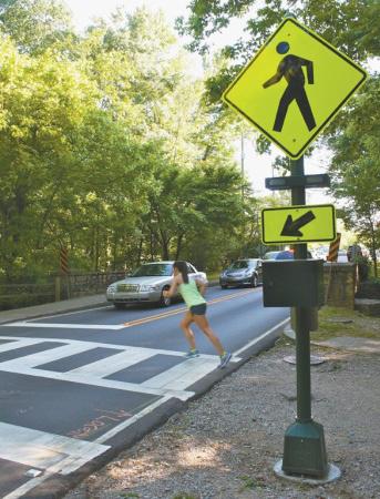
21 Rural Rectangular Rapid Lighting Flashing Policy Beacon (2 of 2) (1 of 2) PEDESTRIAN SAFETY STRATEGIES These high compliance rates are similar to a full traffic signal and a pedestrian hybrid beacon system, both of which stop traffic with steady red signal indications. This study also found that drivers were yielding or slowing down further in advance of the crosswalk with RRFB than with standard round yellow flashing beacons. PROVEN, TRIED, OR EXPERIMENTAL DESCRIPTION AND DEFINITION A rectangular rapid flashing beacon (RRFB) has two rapidly and alternatively flashing rectangular yellow indications attached to supplement the pedestrian warning sign (W11-2) or school crossing sign (S1-1) at a crosswalk. The beacon, when activated manually by a pedestrian or passively by a pedestrian detection system, uses an irregular flash pattern similar to emergency flashers on police vehicles, an alternating wig-wag flashing sequence (left light on, then right light on) with a pulsing light source. SAFETY CHARACTERISTICS The city of St. Petersburg, Florida completed experimentation with RRFB s at 18 pedestrian crosswalks across uncontrolled approaches including before and after data. The results showed high rates of motorist yield to pedestrians compliance, between 80 and 100 percent. These rates are in comparison to far lower rates (in the 15 to 20 percent range) for standard beacons. These high rates of yielding were even sustained two years after the installation of the RRFBs. Due to the low number of installations and research on the RRFBs, they are considered a TRIED strategy, but with promising results including an increase from 16 percent yielding compliance for a standard yellow overhead beacon to 78 percent yielding compliance with the installation of a RRFB (Report FHWA- HRT ). TYPICAL CHARACTERISTICS OF CANDIDATE LOCATIONS The purpose of the RRFB is to increase driver awareness of crosswalks that are not across approaches controlled by YIELD signs, STOP signs, or traffic control signals. They can be used on crosswalks across the approach to and/or egress from a roundabout. As with any new safety strategy implementation, effort should be made to perform outreach to the public to provide information on how the beacon operates and what drivers and pedestrians should do when encountering it. TYPICAL COSTS Costs for the installation of two units (one on either side of the street) range from $10,000 to $15,000. This cost includes all the signs and lights plus the solar panels for powering the unit. The costs vary depending on the type of activation, either manually by the pedestrian or passive detection. MINNESOTA S BEST PRACTICES FOR PEDESTRIAN/BICYCLE SAFETY SEPTEMBER


22 Rural Rectangular Rapid Lighting Flashing Policy Beacon (2 of 2) (2 of 2) Source: FHWA BEST PRACTICE The RRFB offers significant potential safety and cost benefits, because it achieves very high rates of compliance at a very low relative cost in comparison to other more restrictive devices that provide comparable results, such as full midblock signalization. FHWA PEDESTRIAN SAFETY STRATEGIES DESIGN FEATURES The installation of a RRFB needs to include two units, one on the right-hand side and one on the left-hand side of the roadway. It is also recommended to consider placing an additional unit within a median if available. There are specifications for the flash rate, with 70 to 80 periods of flashing per minute and with one of the lights emitting two slow pulses of light during its wig-wag alternating sequence, and the other emitting four rapid pulses. The lights should be normally dark, and simultaneously start their alternating rapid flashing indications when activated as well as stop simultaneously. The lights themselves should be approximately five inches wide by two inches high aligned horizontally and located between the bottom of the warning sign and the top of the supplemental downward diagonal arrow plaque. SOURCES Effects of Yellow Rectangular Rapid-Flashing Beacons on Yielding at Multilane Uncontrolled Crosswalks, FHWA, FHWA-HRT , September MUTCD Interim Approval for Optional Use of Rectangular Rapid Flashing Beacons. FHWA, July 16, MINNESOTA S BEST PRACTICES FOR PEDESTRIAN/BICYCLE SAFETY SEPTEMBER

23 Crosswalk Lighting (1 of 2) PEDESTRIAN SAFETY STRATEGIES vehicle-bicycle crashes; and fatal and serious injury crashes. Research suggests that the crash reduction is the result of the advance warning that is provided to the drivers on the major road; the lighting warns drivers that they are approaching a decision point where they need to pay closer attention because of potential conflicts associated with turning maneuvers. Source: / Ron Bloomquist DESCRIPTION AND DEFINITION This strategy involves the installation of street lights at intersections and crosswalks. In practice, the design of the street lights can vary from low-level, pedestrian-scale decorative lighting to a typical highway intersection style that consists of a luminaire mounted on a davit arm on top of a 30- to 40-foot vertical pole. Street lights can also be located at individual intersections or crosswalks or can be continuous along roadway corridors. SAFETY CHARACTERISTICS Street lights can contribute to safety by providing an advance warning to drivers that they are approaching a point of potential conflict with crossing pedestrians and bicyclists. Driver recognition of pedestrians and bicyclists is also improved because street lights illuminate them when it is dark. PROVEN, TRIED, OR EXPERIMENTAL The use of street lights at rural intersections has been studied extensively and is considered to be a PROVEN effective strategy for reducing a variety of crash types across a range of crash severities, including the following: nighttime crashes; head-on crashes; road departure crashes; vehicle-pedestrian and However, there has been no research into the effectiveness of street lights relative to reducing pedestrian crashes at urban intersections or along urban roadways. This lack of research on the application of street lights to address pedestrian crashes in urban areas may be reflective of circumstances in the Minneapolis St. Paul metropolitan area, where 60 percent of severe vehiclepedestrian and vehicle-bicycle crashes occur during daylight hours and 36 percent occur at night, but at locations that already have street lights in place. The subset of pedestrian and bicycle crashes in urban areas that would be susceptible to correction by the installation of street lights is relatively small. TYPICAL CHARACTERISTICS OF CANDIDATE LOCATIONS Isolated intersections with crosswalks that are not along continuously lit roadways and mid-block crosswalks are prime candidates for installation of street lights. In both cases, the street lights would draw attention to what might be an unexpected situation for motorists pedestrians and bicyclists crossing the road in the dark. TYPICAL COSTS The cost of installing street lights ranges from around $10,000 per intersection for a luminaire on a davit arm on a wooden utility pole to more than $40,000 for MnDOT-style intersection lighting. Decorative lighting can cost up to $1,500 per light for continuous lighting. The initial costs for installing street lighting are considered eligible for both federal and state funding. MINNESOTA S BEST PRACTICES FOR PEDESTRIAN/BICYCLE SAFETY SEPTEMBER
, a davit arm that extends the luminaire out towards the roadway and connects to the vertical pole, and in most")


24 Crosswalk Lighting (2 of 2) The cost for power is approximately $30 per month for a single light at an intersection, and is typically not eligible for federal or state funding. DESIGN FEATURES A typical street light consists of a luminaire (the lighting fixture), a davit arm that extends the luminaire out towards the roadway and connects to the vertical pole, and in most cases a 30- or 40-foot pole. The least expensive installation would attach the davit arm to a wooden utility pole. A more expensive and more attractive option would use a metal pole. Still more expensive options could involve decorative luminaires and poles. PEDESTRIAN SAFETY STRATEGIES Solar-powered lighting fixtures offer another option for reducing power costs. However, the initial costs of solar fixtures are approximately twice the cost of traditional lights. Solar fixtures also require back-up battery packs that require periodic replacement. However, the annual cost of replacing the battery packs is greater than the typical annual cost of power for lighting an intersection. Along high-speed and high-volume arterials, the installation of street lights may require the use of breakaway poles and bases in order to reduce the severity of vehicle crashes involving the street lights. New research summarized in FHWA s Informational Report on Lighting Design for Midblock Crosswalks provides some additional information on the placement of crosswalk lighting to maximize the visibility of pedestrians. See examples of preferred lighting locations in the figures to the right. CONSIDERATIONS BEST PRACTICE While street light installation costs may be eligible to be covered by federal and state funds, ongoing maintenance and power costs are not eligible. One approach to addressing ongoing costs is use of an innovative contracting approach that includes installation as well as the maintenance and power for a specified period of time as part of the construction project contract. SOURCES Federal Highway Administration (FHWA). Roadway Lighting Revisited, Hason, P., Lutkevich, P. May/June 2002 Public Roads Magazine. Federal Highway Administration (FHWA). Informational Report on Lighting Design for Midblock Crosswalks, FHWA-HRT , April Isebrands, H., S. Hallmark, H. Preston, and R. Storm Safety Impacts of Street Lighting at Isolated Rural Intersections Part II. MnDOT. Preston, H. and T. Schoenecker Safety Impacts of Street Lighting at Isolated Rural Intersections. Report MnDOT and Minnesota Local Road Research Board. Along urban and suburban corridors without continuous street lighting, the installation of crosswalk lighting provides a valuable visual cue for drivers. The crosswalk lighting is an advanced warning to pay particular attention because they are approaching a location where something is different the possibility of a pedestrian in the roadway. Properly designed street lights improve driver s visibility to pedestrians during low light conditions. MINNESOTA S BEST PRACTICES FOR PEDESTRIAN/BICYCLE SAFETY SEPTEMBER
. Two features associated with traffic signal installations have been found to reduce pedestrian crashes countdown timers and leading pedestrian intervals.")

25 Traffic Signals (1 of 3) PEDESTRIAN SAFETY STRATEGIES intersection along with the roadway classification should be considered when designing signal elements (American Association of State Highway and Transportation Officials [AASHTO] 2012). Two features associated with traffic signal installations have been found to reduce pedestrian crashes countdown timers and leading pedestrian intervals. Countdown timers are flashing timers, usually installed with pedestrian indication lights, which provide the number of seconds remaining during the pedestrian phase. A leading pedestrian interval provides the pedestrian walk 2 or 3 seconds ahead of the vehicle green, allowing pedestrians a head start and the ability to enter the crosswalk before right-turning vehicles can turn into the crosswalk. DESCRIPTION AND DEFINITION Traffic signals assign right-of-way to various traffic movements at intersections. Signal design has typically focused on the operating characteristics of motorized vehicles. Like the pedestrian hybrid beacons, signals are effective at creating gaps in the traffic allowing pedestrians to cross, however, unlike pedestrian hybrid beacons, signals have turning conflicts and long cycles. Traffic signals are a mobility treatment with benefits for pedestrians and bicyclists in some cases. Pedestrians and bicyclists have considerably different operating characteristics than motor vehicles. Therefore, in locations that accommodate a variety of transportation modes, agencies should consider adjusting traffic signal operations. The speeds and behaviors of bicyclists typically using an One of the most effective measures to reduce pedestrian crashes involving left-turning motorists is the use of separate left turn phasing for motorists. During each signal cycle, motorists are given a left turn green arrow (followed by a yellow arrow) while pedestrians have a steady DON T WALK display. After the yellow arrow, left-turning motorists get a red left-turn arrow, and pedestrians get a WALK display. Exclusive or scramble pedestrian signal timing refers to signal timing that is sometimes used in urban areas where motor vehicles are stopped in all directions simultaneous for a phase of each signal cycle, and pedestrians can cross the street in any direction (including diagonally). However, such timing has been found to be effective primarily on downtown streets with high volumes of pedestrians and low-to-moderate volumes of motor vehicles. This timing scheme should be used with caution, however, because it can increase motorist and pedestrian delays. MINNESOTA S BEST PRACTICES FOR PEDESTRIAN/BICYCLE SAFETY SEPTEMBER


26 SAFETY CHARACTERISTICS Review of the over 4,000 vehicle-pedestrian crashes at intersections in Minnesota between 2007 and 2011 found that over half of the crashes occurred at intersections. Of the intersection crashes, 53 percent occurred at signalized intersections. Traffic Signals (2 of 3) Distribution of Traffic Control for Vehicle-Pedestrian Crashes at Intersections 53% SIGNALIZED INTERSECTION PEDESTRIAN SAFETY STRATEGIES PROVEN, TRIED, OR EXPERIMENTAL Leading pedestrian intervals and pedestrian countdown timers are TRIED safety strategies because of their newness and limited research, but results are promising so far. A 2010 study in the Journal of the Transportation Research Board found an up-to-60 percent reduction in vehicle-pedestrian crashes at intersections that use the leading pedestrian interval strategy (Transportation Research Board 2009). A 2012 study by Chen, et. al., in New York City found that a five percent reduction in pedestrian crashes was associated with converting to leading pedestrian intervals. The same study found that providing exclusive left turn phasing reduced pedestrian crashes by 43 percent. A study in San Francisco (Markowitz, et. al.) found that converting from standard pedestrian signals to countdown signals was associated with up to 25 percent fewer pedestrian crashes after the conversion. ALL-WAY STOP STOP SIGN NOT APPLICABLE TYPICAL CHARACTERISTICS OF CANDIDATE LOCATIONS Locations with high volumes of pedestrian activity such as near transit stops or schools, are candidates for traffic signal improvements. MN MUTCD Warrants should be considered for installation of new signals. TYPICAL COSTS Typical costs for traffic signal measures are as follows: Graphic Source: Minnesota Crash Mapping and Analysis Tool (MnCMAT) ), As a result, traffic signals by themselves are not proven safety devices for pedestrians. The most likely explanation for this is a combination of lack of attention and failure of motorists to yield to pedestrians, as well as a lack of caution and signal compliance by pedestrians in some cases. Leading pedestrian interval The cost to alter the timing of a pedestrian signal can be up to $3,500, depending on the site specifications and the size of the city. Traffic signals Installing a new traffic signal can typically cost between $200,000 to $250,000. Annual maintenance costs are approximately $2,000 to $4,000 per location. MINNESOTA S BEST PRACTICES FOR PEDESTRIAN/BICYCLE SAFETY SEPTEMBER
27 Traffic Signals (3 of 3) Pedestrian signals Pedestrian signals cost approximately $8,000 to $75,000 per intersection and include pedestrian heads and signal heads for the traffic lanes. Pedestrian signal phasing Adjusting signal time can be relatively inexpensive, requiring a few hours of staff time; however, in larger cities, the cost and time may be more significant. Pedestrian countdown timers Countdown timers typically cost between $5,000 to $10,000 per intersection. Right-turn-on-red restrictions The cost for a NO TURN ON RED sign is approximately $200. Electronic NO TURN ON RED signs cost approximately $3,000 to install. Left turn phasing The cost for adjusting signal phasing and/or timing is typically low and requires a few hours of staff time per signal. However, there would be additional costs for new signal heads. Push buttons and signal timing progression The cost for installing a push button with a sign and pedestal or post is approximately $800 to $1200. Adding audible tones or speech messages and/or vibrating surfaces will raise the cost. BEST PRACTICE Traffic Signals are used to assign right of way to conflicting streams of traffic both vehicles and pedestrians at intersections. By themselves, traffic signals are not considered to be pedestrian safety devices more than one-half of pedestrian crashes in Minnesota occur at signalized intersections. Three strategies have been found to reduce the risk for pedestrians at signalized intersections the use of exclusive left turn phasing when pedestrians are present, the addition of countdown timers and incorporating a leading pedestrian interval into the timing plan. DESIGN FEATURES PEDESTRIAN SAFETY STRATEGIES Strategies for improving pedestrian accommodation at signalized intersections include the following: Providing easily accessible pedestrian push buttons for all pedestrian users Keeping signal cycles short (ideally, 90 seconds maximum) to reduce pedestrian delay, considering traffic volume needs Adding countdown timers at locations with pedestrian activity (Note: The 2009 Manual on Uniform Traffic Control Devices now requires the installation of countdown signals whenever new pedestrian signals are installed.) Implementing leading pedestrian intervals Recalling the pedestrian phases (WALK signal display and phases) if pedestrian traffic is frequent Providing push buttons and pedestrian activated walk phases for locations with infrequent pedestrian traffic Maintaining visibility of signals to pedestrians Walk times and flashing DON T WALK consistent with new MN MUTCD guidelines creates longer crossing times for pedestrians, however, these changes should have small effects on vehicle operations. SOURCES American Association of State Highway and Transportation Officials (AASHTO) Guide for the Development of Bicycle Facilities. Fourth Edition. Chen L, Chen C, Ewing R, McKnight CE, Srinivasan R, Roe M Safety countermeasures and crash reduction in New York city experience and lessons learned. Accid Anal Prev. May 31. Federal Highway Administration (FHWA) PEDSAFE Guide. Markowitz, F., Sciortino, S., Fleck, J., Lucero, Y., Bond M Pedestrian Countdown Signals: Experience with an Extensive Pilot Installation. ITE Journal. Transportation Research Board Evaluation of Pedestrian and Driver Behavior at Countdown Pedestrian Signals in Peoria, Illinois. Available at: < Transportation Research Board Safety Effectiveness of Leading Pedestrian Intervals Using the Empirical Bayes Method. Available at: < March. MINNESOTA S BEST PRACTICES FOR PEDESTRIAN/BICYCLE SAFETY SEPTEMBER


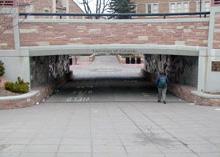
28 Rural Lighting Grade Separated Policy (2 of Crossings 2) (1 of 2) Source: / Dan Burden DESCRIPTION AND DEFINITION A grade seperation separates pedestrians and bicyclists from vehicular traffic by a roadway overpass or underpass. SAFETY CHARACTERISTICS Grade separations can separate vehicular and pedestrian/bicycle traffic, eliminating the possibility of crashes between the two travel modes. The effectiveness of a grade-separated crossing depends on whether or not pedestrians and bicyclists perceive that it is easier and quicker to use than a street crossing. Grade-separated crossings should be designed to minimize the change in the path to allow the most direct route of travel. Because of their high costs, grade-separated crossings should be considered as a last resort, when other measures would not be effective in providing adequate crossing safety for pedestrians and bicyclists. PROVEN, TRIED, OR EXPERIMENTAL PEDESTRIAN AND BICYCLE SAFETY STRATEGIES This is a PROVEN strategy as long as an underpass or overpass of the roadway is located where it is both convenient for pedestrians and bicyclists and in a frequently used pedestrian crossing. The benefits decrease if there is still the ability to cross or it is more convenient to cross the roadway at-grade instead of using the grade separation. Overpasses and underpasses have been associated with an 86 percent reduction in pedestrian crashes and a 90 percent reduction in fatal and injury pedestrian crashes. A 100 percent reduction at these locations is rare because of the occasional pedestrian or bicyclists who decides to cross the roadway at-grade. TYPICAL CHARACTERISTICS OF CANDIDATE LOCATIONS Grade separations are generally warranted at locations with heavy volumes of pedestrian and bicycle traffic crossing a roadway with heavy vehicular traffic. However, pedestrians and bicyclists will generally use grade separations that are located at or very near where they want to cross the road. When considering a grade separation, the following items should be investigated and documented: Pedestrian crossing volumes Type of roadway to be crossed including information on daily volumes, roadway speed and geometry Location of adjacent crossing facilities Predominant type and age of persons who will use the facility Thinking Outside the Box This trail overpass on the Gateway Trail in Washington County is a recycled highway bridge from Koochiching County! MINNESOTA S BEST PRACTICES FOR PEDESTRIAN/BICYCLE SAFETY SEPTEMBER
29 Grade Separated Crossings (2 of 2) TYPICAL COSTS Overpasses and underpasses cost between approximately $500,000 to $4 million dollars, depending on characteristics of the location and crossing. A grade separation should only be constructed when the need for the safe movement of pedestrians and bicyclists cannot be provided in a simpler, more cost-efficient manner. Experience at other grade separations throughout the Minneapolis/St. Paul metro area show that these types of amenities are typically underutilized, since very few places have the large number of pedestrians needed to exceed the capacity of at-grade strategies. DESIGN FEATURES The following steps should be taken to increase pedestrian and bicyclist safety and access at grade-separated crossings: Provide good sight distances in underpasses, preferably with the open ends of the tunnel in view at all times. Good visibility increases the user s sense of security and prevents the user from feeling like other people may be lurking in the tunnel. Provide good lighting and ventilation in tunnels. Include an accessible turning space at the top and bottom of the ramps to the grade-separated crossing. Make pathways wide enough to permit two-way pedestrian/bicyclist traffic. PEDESTRIAN AND BICYCLE SAFETY STRATEGIES Install barriers or landscaping to encourage use of the grade separation and to prevent pedestrians and bicyclists from crossing the roadway at-grade. Provide handrails on overpasses. Minimize grades, cross slopes, and additional travel distances. The Americans with Disabilities Act (ADA) requires that stairs cannot be the only access to grade separations. An elevator or ramp that meets the grade requirements under ADA regulations must be provided. Additional guidance concerning pedestrian grade separations can be found in the AASHTO publication, Guide Specifications for Design of Pedestrian Bridges. BEST PRACTICE Grade Separated Crossings are a proven safety strategy, with benefits maximized at locations where it is more convenient to use the underpass or overpass than to cross the roadway at-grade (or if a physical barrier is erected to prevent the at-grade crossing). Due to the high cost of construction, grade separations are most often considered where high volumes of pedestrian/bicycle traffic (regional trails and major pedestrian generators) must cross major, high speed roadways with high volumes of traffic (principal arterials). SOURCES American Association of State Highway and Transportation Officials (AASHTO) Guide for the Planning, Design, and Operation of Pedestrian Facilities. July. Federal Highway Administration (FHWA) Designing Sidewalks and Trails for Access, Part II of II: Best Practices Design Guide. Moore, R.I. and S.J. Older Pedestrians and Motorists Are Compatible in Today s World. Traffic Engineering. Institute of Transportation Engineers. Washington, D.C. September. MINNESOTA S BEST PRACTICES FOR PEDESTRIAN/BICYCLE SAFETY SEPTEMBER


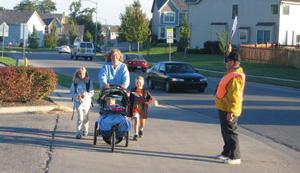
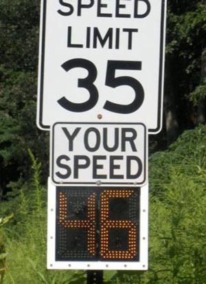
30 Rural Lighting Crossing Policy Guards (2 of 2) (1 of 2) PEDESTRIAN AND BICYCLE SAFETY STRATEGIES 2012 Minnesota Statutes Pedestrian School crossing guard in Seward Neighborhood, Minneapolis, Source: City of Minneapolis Pedestrian Master Plan, DESCRIPTION AND DEFINITION Typically stationed at roadway crosswalks near schools, a trained crossing guard can temporarily stop the flow of traffic and monitor children s crossing behavior so pedestrians can cross a roadway more safely. There are variations as to who provides crossing guard duties, including trained students or teachers at the adjacent school and trained adult crossing guards. SAFETY CHARACTERISTICS According to the National Cooperative Highway Research Program 500 report regarding school zones, the presence of crossing guards was found to be the most effective measure in terms of motorists complying with the regulatory flashing speed limit sign. (c) It is unlawful for any person to drive a motor vehicle through a column of school children crossing a street or highway or past a member of a school safety patrol or adult crossing guard, while the member of the school safety patrol or adult crossing guard is directing the movement of children across a street or highway and while the school safety patrol member or adult crossing guard is holding an official signal in the stop position. A peace officer may arrest the driver of a motor vehicle if the peace officer has probable cause to believe that the driver has operated the vehicle in violation of this paragraph within the past four hours. PROVEN, TRIED, OR EXPERIMENTAL Crossing guards are considered a TRIED safety strategy since there have been almost no evaluation of the overall safety effectiveness of the strategy. Research has shown that adult crossing guards present during school arrival and dismissal periods can result in reduced vehicle speeds and better compliance with school zone speed limits. TYPICAL CHARACTERISTICS OF CANDIDATE LOCATIONS This strategy is typically implemented as part of a broader implementation of the Safe Routes to School program; therefore, it is targeted toward motorists driving through school zones and children walking or biking to school. MnDOT s Safe Routes to School program provides funding to community and school groups to make improvements to the routes children use to walk and bike to school. MINNESOTA S BEST PRACTICES FOR PEDESTRIAN/BICYCLE SAFETY SEPTEMBER
31 Crossing Guards (2 of 2) TYPICAL COSTS The costs associated with crossing guards vary depending on the source of the crossing guards, from school-age children volunteering at no cost to trained adult crossing guards employed by the school. DESIGN FEATURES To be effective, crossing guards should be well trained and equipped with bright, reflective safety vests and STOP paddles. Implementation of crossing guards and an increase in police enforcement of both the school speed zone and compliance with vehicles yielding to the crossing guards may be necessary. Also, public information and education campaign geared towards the parents of school-age children may be beneficial so parents know the safe routes to school for their children and also are more aware of pedestrian rights and activities for when they themselves are driving through the school zone. PEDESTRIAN AND BICYCLE SAFETY STRATEGIES Some schools have suggested the implementation of a traffic signal instead of crossing guards, with the cost of the signal paid by the road authority. It has been documented that not all pedestrians actually activate the push button at signals and wait for traffic to stop before proceeding across the roadway. In a 2005 MnDOT study (Pedestrian Activated Solar Warning Flasher Test, July 2005) that looked at push button usage at an activated pedestrian warning sign, only 15 to 35 percent of users pushed the button before proceeding across the roadway. The 35 percent was during the first three months of installation with the percent of users pushing the button going down over time to around 15 percent. The presence of a crossing guard therefore, would still be beneficial in many elementary school situations for consistent and proper use of the signal and for proper behavior when crossing the roadway. BEST PRACTICE Use of student crossing guards, with adult supervision, at crossings of lower speed and lower volume collectors is appropriate, but adults should be employed for higher speed and higher volume arterials. SOURCES National Cooperative Highway Research Program. NCHRP Report 500 Volume 23: A Guide for Reducing Speeding-Related Crashes. Washington, DC: The National Academies Press, St. Paul Public School Crossing Guard Training Video. Available at: < St. Paul Public School Patrol Supervisors Manual. Available at: < Minnesota Department of Transportation Pedestrian Activated Solar Warning Flasher Test. July. MINNESOTA S BEST PRACTICES FOR PEDESTRIAN/BICYCLE SAFETY SEPTEMBER

32 Shared Space and Complete Streets (1 of 2) SAFETY CHARACTERISTICS PEDESTRIAN AND BICYCLE SAFETY STRATEGIES The theory regarding safety effects of shared space is that by taking away traffic regulation and traffic control devices and by sharing the road space, a certain feeling of insecurity can be created. Shared streets are only appropriate at a limited number of streets with a nearly equal number of motorized and non-motorized users. PROVEN, TRIED OR EXPERIMENTAL Source: Wikimedia Commons, DeFacto Example of shared space DESCRIPTION AND DEFINITION Shared space, sometimes called Home Zones, Slow Zones, or Streets for Living, is a European design philosophy that involves vehicles, bicycles, and pedestrians sharing the same space. Unlike traditional efforts to manage traffic volume and speed in areas with heavy pedestrian usage, shared space relies on voluntary behavioral changes by all road users, supported by the design and layout of the public space. Shared space is typically characterized by the absence of traffic signals and other traffic control devices, but basic traffic rules still apply. The aim is common use of the available space by all users, who travel at walking speeds. Motorists, pedestrians and bicyclists must all watch out for each other, and motorists must yield to those on bike and on foot. A review of the research indicates that the concept of shared space has only been TRIED in a handful of locations in Europe. Safety evaluations have been conducted at only three locations in the Netherlands, none of which was considered to be crash-prone. A before-and-after study of the locations found a small decrease in crashes in the converted spaces, but the change was not statistically significant and there was no mention of types of crashes, so the effect on bicycles and pedestrians is unknown. The results of the research suggest that due to the very small sample size of the number of locations converted and the extremely small number of crashes in the data set, there is no clear conclusion regarding the safety effects of shared spaces. TYPICAL CHARACTERISTICS OF CANDIDATE LOCATIONS Areas with the following characteristics could be considered candidates for development as a shared space: Approximately equal levels of vehicular and pedestrian/bicyclist traffic Approximately equal travel speeds for all users (i.e. walking speed) Areas in small shopping districts or in small towns with virtually no through traffic (It is essential that the road users have some tie to the area.) All on-street parking must be prohibited in order to provide clear sight lines between all shared space users. MINNESOTA S BEST PRACTICES FOR PEDESTRIAN/BICYCLE SAFETY SEPTEMBER
33 A precondition for the positive performance of the shared space is that there is a more convenient arterial nearby to handle the through-trip drivers who need to be discouraged from entering the shared space. TYPICAL COSTS Shared Space and Complete Streets (2 of 2) Available research did not include information regarding the cost of implementing the shared spaces. Annual maintenance costs may be reduced because of the absence of traffic signals and other traffic control devices. However, the conversion of the street or sidewalk crossing area to the shared space without curbs and with some type of color or pavement contrast between the road and the sidewalk would require total reconstruction. DESIGN FEATURES PEDESTRIAN AND BICYCLE SAFETY STRATEGIES The European examples illustrated in the research reports suggest a streetscape that in some ways is similar to what would be found in small shopping areas and small towns in the U.S. a space in the center of the rightof-way designated for use by vehicles, a sidewalk between the vehicle space and building fronts for pedestrians, street lights, street furniture (benches and bollards), and landscaping. What is different about shared space is the lack of a curb and gutter to separate vehicles from pedestrians (accomplished by using different colors and patterns of brick pavers) and the complete absence of traffic signals and traffic control devices. A good phrase to summarize the need to determine the right locations to implement shared spaces and other pedestrian and bicycle amenities is as follows: Not all modes on all roads, right mode on right road. The current practice in Minnesota is to use the concept of Complete Streets as opposed to Shared Spaces and keep traffic and pedestrian traffic separated. BEST PRACTICE Shared Space is a technique that involves vehicles, bicycles and pedestrians all using the same shared space that is typically characterized by the absence of all traffic control devices, but where basic traffic rules still apply. This technique is usually reserved for the small number of streets with nearly equal numbers of motorized and non-motorized users and where travel speeds for all uses is approximately equal. In Minnesota, the concept manifests itself in the form of Complete Streets. Complete Streets is a transportation network approach, involving providing safe access for all street users, that must be considered during the planning and design phases of all roadway improvement projects. Complete Streets is neither proscriptive nor a mandate for an immediate retrofit, it is however, intended to be reflective of local needs and to serve adjacent land uses. SOURCES Gerlach I., Jurgen, R. Methorst, J. Leven Sense and Nonsense about Shared Spaces. Routes/Roads Magazine, RR Methorst, R., J. Gerlach, D. Boenke, J. Leven Shared Space: Safe or Dangerous? WALK21 Conference. October. Toronto. MINNESOTA S BEST PRACTICES FOR PEDESTRIAN/BICYCLE SAFETY SEPTEMBER


 Guide for the Development of")

34 Road Diet (1 of 3) DESCRIPTION AND DEFINITION BICYCLE SAFETY STRATEGIES Before and after photos of road diet conversions Road diet is a term used for the reallocation of roadway lanes and/or space to integrate additional modes, such as bike lanes, pedestrian crossing islands, or parking, or a combination of modes on existing roadways. A common roadway reconfiguration involves converting an undivided four-lane (two-way) roadway into a three-lane roadway made up of two through lanes, a center two-way left turn lane, and a shoulder/bike lane, as shown below. BEFORE AFTER 86th Street and Wentworth Avenue, City of Bloomington, before and after a diet improvement 86th Street and Bryant, City of Bloomington, before and after a diet improvement Source: American Association of State Highway and Transportation Officials (AASHTO) Guide for the Development of Bicycle Facilities, Fourth Edition, North 130 th Street in Seattle, Washington, before and after a road diet improvement MINNESOTA S BEST PRACTICES FOR PEDESTRIAN/BICYCLE SAFETY SEPTEMBER
35 Road Diet (2 of 3) SAFETY CHARACTERISTICS Modifying from four lanes to two travel lanes with a two-lane left-turn lane has shown a 29 percent reduction in all roadway crashes (National Cooperative Highway Research Program [NCHRP] Project Final Report). According to the American Association of State Highway and Transportation Officials (AASHTO) Guide for the Development of Bicycle Facilities, Fourth Edition, safety benefits associated with this type of road diet include the following: Typically lower speeds due to one travel lane in each direction, and no passing allowed, requiring vehicles driving at higher speeds to slow down when following vehicles traveling at posted speeds. Lower travel speeds may reduce potential crash severities for all users. Reduction in the number of travel lanes (to just one in each direction) substantially reduces the likelihood of multiple-threat crashes (where a driver in one lane stops to yield, but the driver in the adjacent lane continues at speed). This reduction is a safety benefit for pedestrians, left-turning motorists, and bicyclists. The addition of left turn lanes provides a place for both motorists and bicyclists to make left turns, thus reducing the incidence of left-turn, rear-end crashes. Reduced incidence of sideswipe crashes because motorists no longer must change lanes to pass a vehicle waiting to make a left turn from the left-most through lane. The potential to construct a raised median or small refuge island at some pedestrian crossing locations, improving ease of pedestrian crossings and reducing the likelihood of crashes involving pedestrians. Improves visibility for left-turning vehicles. PROVEN, TRIED, OR EXPERIMENTAL The conversion from a four-lane undivided to a three-lane roadway is a PROVEN safety strategy for vehicle crashes, but with the limited amount of research on the benefits for pedestrian safety, this strategy is TRIED for pedestrian and bicycle crashes. BICYCLE SAFETY STRATEGIES TYPICAL CHARACTERISTICS OF CANDIDATE LOCATIONS Locations with the most success with road diet implementation have 15,000 or fewer vehicles per day, but there are a number of roads in the Minneapolis/St. Paul metropolitan area with volumes as high as 20,000 vehicles per day that have had successful road diet implementations. Before implementing a road diet, a traffic study should be conducted to evaluate potential reductions in crash frequency and severity, to evaluate motor vehicle capacity and level of service, to evaluate Bicycle LOS [Level of Service], and to identify appropriate signalization modifications and lane assignment at intersections. AASHTO Guide for the Development of Bicycle Facilities, Fourth Edition, 2012, Section 4 Driveway density, transit routes, and the number and design of intersections along the corridor, as well as operational characteristics, are some considerations to be evaluated before deciding to implement a road diet. Improvements to intersection turn lanes, signing, pavement markings, traffic control devices, transit stops, and pedestrian and bicyclist facilities may be needed to support this concept. TYPICAL COSTS The cost for a road diet improvement, which involves re-striping a fourlane street to one lane in each direction and adding a two-way left-turn lane with bicycle lanes, is about $25,000 to $40,000 per mile. If done during planned resurfacing, costs are minimal. Cost depends partly on the number of lane lines that need to be repainted. The estimated cost of extending the sidewalks or constructing a raised median can amount to $100,000 per mile or more. MINNESOTA S BEST PRACTICES FOR PEDESTRIAN/BICYCLE SAFETY SEPTEMBER
36 Road Diet (3 of 3) DESIGN FEATURES As shown in the graphic to the right from the City of Minneapolis Ten- Year Transportation Action Plan, there are many variations of the use of an 80 foot right-of-way cross section, including the typical road diet discussed with one lane of traffic in each direction and a center turn lane. BICYCLE SAFETY STRATEGIES ALTERNATIVE CROSS SECTIONS BEST PRACTICE Road diets refer to the conversion of roadways from four travel lanes to two and provide a number of safety benefits for pedestrians and bicycles. The reduction in the number of lanes regularly results in a decrease in travel speeds. In addition, the likelihood of multiple (vehicle) threats for pedestrians crossing the roadway is virtually eliminated and a space is created in the road that can be converted to a bicycle lane. Minor arterials and collectors with traffic volumes under 18,000 vehicles per day are considered candidates for conversion. SOURCES American Association of State Highway and Transportation Officials (AASHTO) Guide for the Planning, Design, and Operation of Pedestrian Facilities. Available for purchase from AASHTO at: < American Association of State Highway and Transportation Officials (AASHTO). Guide for the Development of Bicycle Facilities, Fourth Edition. FHWA CMF Clearinghouse. The Safety and Operational Effects of Road Diet Conversion in Minnesota. Available at: < Source: City of Minneapois s Ten-Year Transportation Action Plan Federal Highway Administration (FHWA). Office of Safety Bicycle and Pedestrian Safety. < fhwa.dot.gov/ped_bike/>. 80' Federal Highway Administration (FHWA). Designing Walkable Urban Thoroughfares: A Context Sensitive Approach. Traffic Analysis Toolbox. Available at: < Transportation Research Board of the National Academies NCHRP Report 617: Accident Modification Factors for Traffic Engineering and ITS Improvements, Harkey, D., Council, F., Srinivasan, R., Lyon, C., Persaud, B., Eccles, K., Lefler, N., Gross, F., Baek, J., Hauer, E. and Bonneson, J. Institute of Transportation Engineers (ITE). Road Diet Handbook: Setting Trends for Livable Streets. Available for purchase from ITE at: < National Cooperative Highway Research Program (NCHRP) Crash Reduction Factors for Traffic Engineering and ITS Improvements. Project Final Report. Pedsafe: Pedestrian Safety Guide and Countermeasure Selection System < September. MINNESOTA S BEST PRACTICES FOR PEDESTRIAN/BICYCLE SAFETY SEPTEMBER

37 Rural Lighting On-Road Policy Bike (2 Lane of 2) (1 of 3) DESCRIPTION AND DEFINITION According to MnDOT s Bikeway Facility Design Manual, A bike lane is a portion of the roadway or shoulder designated for exclusive or preferential use by people using bicycles. Bicycle lanes are distinguished from the portion of the roadway or shoulder used for motor vehicle traffic by striping, marking, or other similar techniques. SAFETY CHARACTERISTICS The real value of on-road bike lanes is to segregate modes of traffic by their speed. This provides for uniform speeds, eliminating the slowing of vehicle traffic due to a bicycle in the lane. PROVEN, TRIED, OR EXPERIMENTAL Bike lanes can be considered TRIED safety strategy. While there have been many installations and various evaluations, the results of the studies were almost equally divided between locations where bike crashes increased versus locations where they decreased. BICYCLE SAFETY STRATEGIES TYPICAL CHARACTERISTICS OF CANDIDATE LOCATIONS According to MnDOT s Bikeway Facility Design Manual, the following factors should be considered when implementing on-road bike lanes: Traffic volumes, both peak hour and daily for both vehicular and bicycle traffic Higher motor vehicle traffic volumes increase risks for bicyclists; therefore, the bikeway requires increased width to separate bicyclists from motor vehicles. Traffic speeds High motor vehicle speed has a negative impact on bicyclist risk and comfort unless mitigated by design treatments. On-street parking The presence of on-street parking increases the width needed in an adjacent bike lane and also increases the risk of bicyclists being hit by opening car doors. Intersections and driveways Most bicycle crashes with motor vehicles occur at intersections and driveways. Adding bike lanes without full consideration of travel throughout the corridor may increase conflicts with turning vehicles. Right-of-way constraints The ability to accommodate bike lanes at their appropriate width is usually limited by the total available right-of-way. Vehicle turn lane configuration Turn lanes require extra consideration and care as they relate to bike lanes. Topography, grades and sight distances The topography of the roadway affects the width of the bike lane. Additional bikeway width or separation from the roadway may be needed on roads with hills or curves. Vehicles tend to encroach on the inside of curves, and inadequate sight distance may be due to restrictive roadway geometry in locations of rough terrain. Bicyclist speeds are greatly influenced by the grade; with faster speeds on steep downgrades, and with slower speeds on upgrades. Volume of large trucks Where there is more than 10 percent of the daily volume, or over 250 heavy vehicles, during the peak hour, an increase in lane width, an off-road bikeway, or an increase in separation between the bike lane and the travel lane should be considered. MINNESOTA S BEST PRACTICES FOR PEDESTRIAN/BICYCLE SAFETY SEPTEMBER
38 Bus routes Bus routes have both advantages (buses typically going similar speed as bicycles) and disadvantages (regular stopping of the bus requires more interaction between bicyclists and buses). Bicyclist characteristics The bike lane may be used in different ways by a range of bicyclists, from children with limited bicycling ability to advanced cyclists and commuters who prefer limited stops and detours from the road. TYPICAL COSTS Typical costs range from $16,000 per mile for restriping to $500,000 per mile for overlay to $5 million per mile for reconstruction. DESIGN FEATURES MnDOT s Bikeway Facility Design Manual provides information, shown to the right, on the typical roadway configurations for implementing bike lanes and design criteria for appropriate bike lane widths. Other design features to consider with regard to on-road bike lanes include the following: Rumble strips Drainage and drainage grates Bypass lanes Alternate bike routes C L Rural Lighting On-Road Policy Bike (2 Lane of 2) (2 of 3) 3.6 m (12 ft) typical 1.2 m (4 ft) min. NO PARKING WITH STANDARD GUTTER PAN >0.3 m (1 ft) C L 3.6 m (12 ft) typical Climbing lanes Lighting Traffic calming 1.5 m (5 ft) min. NO PARKING WITH NO GUTTER SEAM IN BIKE LANE C L 3.6 m (12 ft) typical m (5-6 ft) min. WITH ON STREET PARKING ALLOWED m (7-10 ft) parking lane BICYCLE SAFETY STRATEGIES Bikeway Design Selection for Urban (Curb and Gutter) Cross Section English Units Motor Vehicle ADT (two-lane; vehicles per day) Motor Vehicle ADT (four-lane; vehicles per day) Motor Vehicle Speed < ,000 1,000 2,000 2,000 5,000 N/A N/A 2,000 4,000 4,000 10,000 5,000 10,000 10,000 20, mph SL WOL WOL WOL BL = 5 ft N/A >10,000 >20, mph SL with sign WOL BL = 5 ft BL = 5 ft BL = 6 ft BL = 6 ft 35 to 40 mph WOL BL = 5 ft BL = 5 ft BL = 6 ft BL = 6 ft BL = 6 ft or PS = 8 ft 45 mph and greater BL = 5 ft BL = 5 ft BL = 6 ft BL = 6 ft BL = 6 ft or PS = 8 ft ADT = average daily traffic; BL = bicycle lane; PS = paved shoulder; SL = shared lane; SUP = shared use path; WOL = wide outside lane Source: MnDOT Bikeway Facility Design Manual, March 2007, Table 4-1. SUP or PS = 10 ft Bikeway Design Selection for Rural (Shoulder and Ditch) Cross Section English Units Motor Vehicle ADT (two- lane; vehicles per day) Motor Vehicle ADT (four-lane; vehicles per day) Motor Vehicle Speed On-Road Bikeway Design Selection Tables MnDOT Bikeway Facility Design Manual 25 mph PS = 4 ft or SL 30 mph PS = 4 ft or SL 35 to 40 mph PS = 4 ft or SL 45 mph and greater < ,000 1,000 2,000 2,000 5,000 N/A N/A 2,000 4,000 4,000 10,000 PS = 4 ft or SL PS = 4 ft or WOL PS = 4 ft or WOL PS = 4 ft or WOL 5,000 10,000 10,000 20,000 PS = 4 ft PS = 4 ft N/A >10,000 >20,000 PS = 4 ft PS = 4 ft PS = 6 ft PS = 6 ft PS = 6 ft PS = 6 ft PS = 6 ft PS = 8 ft PS = 4 ft PS = 4 ft PS = 6 ft PS = 8 ft PS = 8 ft SUP or PS = 10 ft ADT = average daily traffic; BL = bicycle lane; PS = paved shoulder; SL = shared lane; SUP = shared use path; WOL = wide outside lane Source: MnDOT Bikeway Facility Design Manual, March 2007, Table 4-2. MINNESOTA S BEST PRACTICES FOR PEDESTRIAN/BICYCLE SAFETY SEPTEMBER


39 On-Road Bike Lane (3 of 3) BIKE LANES AND RIGHT TURNS CYCLE TRACKS BICYCLE SAFETY STRATEGIES An important feature when designing a bike lane is the right turn lane at intersections. The current practice is to have dashed lines approaching the intersection and encouraging right-turning vehicles to cross the bike lane and get to the right side before the intersection, as shown in the illustration to the right. WRONG RIGHT SOURCES A variation of the bike lane is the cycle track, a striped and signed lane for bicycle traffic with onstreet parking to the left of the bike lane with a buffered area between the bike lane and parking. An example from the City of Minneapolis is shown in the illustration below. Other variations in cycle tracks include raised cycle tracks that are vertically separated from motor vehicle traffic and two-way cycle tracks that include both directions of bike traffic on one side of a roadway. Additional information on cycle tracks can be found in the sources of this section. Cycle Tracks and Intersections Cycle tracks are not recommended along corridors with multiple and closely spaced intersections or access points. Cycle tracks work well on roadways with longer block and few cross streets. BEST PRACTICE On-Road Bicycle Lanes provide a designated space for the exclusive use of bicycles; creating a separation of vehicles by size, weight and speed. The safest applications of On-Road Bicycle Lanes would be on roadways with lower speeds, lower volumes of traffic and fewer heavy commercial vehicles. Alta Planning and Design, Portland City Traffic Engineer Robert Burchfield, Cycle Tracks: Lessons Learned, February 4, < stud_docs/cycle%20track%20lessons%20learned.pdf>. City of Minneapolis s Cycle Track Website: Jensen, S.U Bicycle Tracks and Lanes: a Before-After Study. Transportation Research Board, 87th Annual Meeting, Compendium of Papers. CD-ROM. Washington, D.C. Minnesota Department of Transportation (MnDOT) Bikeway Facility Design Manual. Accessed at: < >. March. National Association of City Transportation Officials (NACTO) Website: < Rodegerdts, L. A., B. Nevers, and B. Robinson Signalized Intersections: Informational Guide. FHWA-HRT Turner, S. A., G. Wood, T. Hughes, and R. Singh Safety Performance Functions for Bicycle Crashes in New Zealand and Australia. Presented at the 90th Annual Meeting of the Transportation Research Board. Washington, D.C. MINNESOTA S BEST PRACTICES FOR PEDESTRIAN/BICYCLE SAFETY SEPTEMBER
40 Shared (Paved) Shoulder Bicycle Lanes (1 of 3) DESCRIPTION AND DEFINITION Paved Shoulders A paved shoulder that is continuous and on the same level as the regular travel lanes available for use bicycles and pedestrians. The width of paved shoulders for use by bicyclists should be based on the context and conditions of adjacent lanes on the roadway. Paved shoulders for bicycle usage typically range from 4 feet for uncurbed cross sections with no vertical obstructions immediately adjacent to the roadway to 5 or more feet for roadways with guardrail, curbs, or other roadside barriers. Consideration of increasing shoulder width should be given if any of the following situations is present on a specific roadway: High bicycle usage is expected. Motor vehicle speeds exceed 50 mph. There is higher than average heavy trucks, buses, or recreational vehicles. The right side of the roadway contains static obstructions. Paved shoulders should be included on both sides of two-way roadway in rural areas, whenever possible. More information on implementing shared shoulder bicycle lanes with rumble strips can be found in the Bicycle Friendly Rumble Strip section (Page 45). Bike Lanes Bike lanes are a portion of the roadway that delineates available roadway space for preferential use by bicyclists. They are most appropriate for roadways in urban and suburban areas, or where there is high potential for bicycle usage in rural areas. Differences between Paved Shoulders and Bike Lanes Paved shoulders may be designated as bike lanes through the installation of bicycle lane symbol markings; however, the shoulders marked as bike lanes must still meet bike lane criteria. BICYCLE SAFETY STRATEGIES State laws and local ordinances should be considered when implementing bike lanes, as they may have an impact on bike lane design, such as the placement of dashed lane lines. Motorists are prohibited from using bike lanes for driving, but many state vehicle codes allow or direct drivers to use bike lanes when turning or merging, maneuvering into or out of parking spaces, and for emergency avoidance maneuvers or breakdowns. Some state codes also allow buses, garbage collectors, and other public vehicles to use bike lanes temporarily and do not prohibit parking in bike lanes unless a local agency prohibits parking and erects signs accordingly. AASHTO 2012 AASHTO s Guide for the Development of Bicycle Facilities, Fourth Edition, states the following: It is important to understand the differences between paved shoulders and bike lanes, particularly when a decision needs to be made as to which facility is more appropriate for a given roadway. Bike lanes are travel lanes, whereas in many jurisdictions, paved shoulders are not (and can therefore be used for parking). Paved shoulders, if provided on intersection approaches, typically stay to the right of right-turn lanes at intersections, whereas bike lanes are placed on the left side of right-turn lanes because they are intended to serve through movements by bicyclists; through bicyclists should normally be to the left of right-turning motor vehicles. To avoid conflicts on roadways with paved shoulders that approach right-turn lanes, some jurisdictions introduce a bike lane only at the intersections, and then transition back to a paved shoulder. AASHTO 2012 MINNESOTA S BEST PRACTICES FOR PEDESTRIAN/BICYCLE SAFETY SEPTEMBER

41 Shared (Paved) Shoulder Bicycle Lanes (2 of 3) BICYCLE SAFETY STRATEGIES The following table documents considerations that should be made when implementing either paved shoulders or bike lanes. Type of Bikeway Paved Shoulder Best Use Rural highways that connect town centers and other major attractors. Motor vehicle Design Speed Variable. Typical posted rural highway speeds (generally 40 to 55 mph). General Considerations for Paved Shoulders vs. Bike Lanes Traffic Volume Variable. Classification or Intended Use Rural roadways; inter-city highways. Other Considerations Provides more shoulder width for roadway stability. Shoulder width should be dependent on characteristics of the adjacent motor vehicle traffic that is, wider shoulders on higher-speed and/or higher volume roads. Bike Lane Major roads that provide direct, convenient, quick access to major land uses. Also can be used on collector roads and bury urban streets with slower speeds. Generally, any road where the design speed is more than 25 mph. Variable. Speed differential is generally a more important factor in the decision to provide bike lanes than traffic volumes. Arterials and collectors intended for major motor vehicle traffic movements. Source: AASHTO s Guide for the Development of Bicycle Facilities, Fourth Edition (2012), Table 2-3, General Considerations for Different Bikeway Types. Where motor vehicles are allowed to park adjacent to bike lane, provides a bike lane of sufficient width to reduce probability of conflicts due to opening vehicle doors and objects in the road. Analyze intersections to reduce bicyclist/motor vehicle conflicts. SAFETY CHARACTERISTICS The shared shoulder/bike lane provides space outside of the travel lanes for bikes. The paved shoulder also provides an improved road edge that has resulted in a reduction in road departure crashes and a refuge for disabled vehicles. Both paved shoulders and bike lanes improve conditions for bicyclists on roadways with higher speeds or traffic volumes. Shoulders also increase motorist comfort by providing more consistent separation between bicyclists and passing motorists. Bike lanes also improve sight distance for motorists at driveways and provide a buffer area between sidewalks and traffic lanes. However, both paved shoulders and bike lanes may increase roadway crossing distances for pedestrians (AASHTO 2012). Properly designed bike lanes encourage bicyclists to operate in a manner consistent with the legal and effective operation of all vehicles. AASHTO 2012 MINNESOTA S BEST PRACTICES FOR PEDESTRIAN/BICYCLE SAFETY SEPTEMBER
42 Shared (Paved) Shoulder Bicycle Lanes (3 of 3) PROVEN, TRIED, OR EXPERIMENTAL Shared shoulders and bike lanes are considered a TRIED method. Existing paved shoulder/bike lane combinations have obvious comfort benefits to bicyclists because they provide bicyclists with a place to ride separately from lanes where motor vehicles travel, especially on the state system. There have been no rigorous statistical evaluations, however, on the crash effects of shared shoulders/bike lanes. The challenge in studying the safety of the shoulder for bicyclists is the small number of bicycle crashes along rural roadways where the shared shoulder/bike lane is most likely to be implemented. TYPICAL CHARACTERISTICS OF CANDIDATE LOCATIONS Typically, shared shoulders and bike lanes are considered for rural application, but may be candidates for some urban corridors with wide shoulders. TYPICAL COSTS On two-lane rural roadways, adding a paved shoulder ranges from $60,000 per mile for 4-foot-wide shoulders to more than $100,000 per mile or more for 8-foot-wide shoulders, depending on site conditions. BICYCLE SAFETY STRATEGIES DESIGN FEATURES MnDOT s Bikeway Facility Design Manual, provides information on the design features to consider and appropriate size of features for a shared shoulder bike lane design. (See On-Road Bike Lane Section for Bikeway Design Selection.) Under most circumstances, the recommended width for bike lanes is 5 feet. Wider bicycle lanes may be desirable under the following conditions: The lane is adjacent to a narrow parking lane (less than or equal to 7 feet) where there is higher parking turnover. The area where the lane is proposed experiences or is expected to experience high bicycle usage; in this situation, a wider bike lane would make it possible for bicyclists to ride side-by-side or pass each other without leaving the bike lane. The lane is adjacent to high-speed and/or high-volume vehicle travel lanes, or there is a high volume of heavy vehicles. C L BEST PRACTICE Shared Shoulder Bicycle Lanes provide a designated space outside the travel lane for the preferential use by bicycles (use of the paved shoulder by pedestrians and for temporary parking by vehicles with mechanical problems is also allowed). Shared Shoulder Bicycle Lanes are primarily considered a rural application in corridors that experience moderate to high bicycle use. SOURCES 3.6 m (12 ft) travel lane (typical) m* (4-10 ft) shoulder lane American Association of State Highway and Transportation Officials (AASHTO) Guide for the Development of Bicycle Facilities. Fourth Edition. Minnesota Department of Transportation (MnDOT) Bikeway Facility Design Manual. Available at: < >. March. MINNESOTA S BEST PRACTICES FOR PEDESTRIAN/BICYCLE SAFETY SEPTEMBER


43 Bicycle Boulevards (1 of 3) BICYCLE SAFETY STRATEGIES City of Berkeley, California, Bicycle Boulevard Pavement Marking DESCRIPTION AND DEFINITION City of Berkeley, California, Bicycle Boulevard Route Guidance Sign A bicycle boulevard is a local street or series of connected local street segments that has been designated for use by bicycles and modified to provide priority treatment for bicyclists, while discouraging the use of these facilities by through traffic. Bicycle boulevards are intended to create conditions favored by bicyclists by taking advantage of bicycle-friendly characteristics that are typically found on local/residential streets low traffic volumes and low vehicle operating speeds. SAFETY CHARACTERISTICS The research on bicycle boulevard safety is relatively sparse, but there is evidence to suggest that risk associated with bicycle riding is correlated with high traffic volumes, high vehicle speed, and the presence of heavy vehicles. The primary safety characteristics associated with bike Example Bicycle Boulevard in Minneapolis, Bryant Ave MINNESOTA S BEST PRACTICES FOR PEDESTRIAN/BICYCLE SAFETY SEPTEMBER

44 Bicycle Boulevards (2 of 3) BICYCLE SAFETY STRATEGIES boulevards relate to the fact that local/residential streets with low volumes, low operating speeds, low turning volumes, and few heavy vehicles should reduce the number and severity of bicycle-involved crashes compared to traveling on higher-speed, higher-volume arterials. PROVEN, TRIED, OR EXPERIMENTAL There has not been a sufficient number of bicycle boulevards implemented and evaluated in order to document their safety characteristics so, therefore, they are considered EXPERIMENTAL. However, the one research report documented in the Federal Highway Administration s (FHWA s) Crash Modification Factors Clearinghouse found that street type does matter for bicycle safety; arterials consistently had higher bicycle crash rates than bicycle boulevards, and the implementation of seven bicycle boulevards in Berkeley, California, resulted in a 60 percent reduction in bicycle involved crashes. TYPICAL CHARACTERISTICS OF CANDIDATE LOCATIONS A typical candidate for the development of a bicycle boulevard would be a local/ residential street that is parallel to and near an arterial and is of sufficient length to reasonably serve long-distance bicycle trips. TYPICAL COSTS It is practically impossible to identify general implementation costs for bicycle boulevards because many local/residential streets likely already have most of the desirable characteristics. However, the most likely revisions would involve moving STOP signs and adding guide signs, both of which could be done at very low cost. Other improvements involving crossing arterials would be somewhat more costly $15,000 to $30,000 for adding median pedestrian refuge islands, $5,000 to $10,000 for curb extensions, and $10,000 to $120,000 for pedestrian traffic control, such as retangular rapid flash beacons or traffic signals. Example pavement marking designating a bicycle boulevard MINNESOTA S BEST PRACTICES FOR PEDESTRIAN/BICYCLE SAFETY SEPTEMBER
45 Bicycle Boulevards (3 of 3) BICYCLE SAFETY STRATEGIES DESIGN FEATURES Because bicyclists riding on bicycle boulevards typically share the road with other traffic, the low volume and speed usually found on residential streets does not indicate the need to provide dedicated bicycle lanes. Residential street systems may require a number of low-cost modifications to encourage use by bicyclists, including (1) reorienting STOP signs at through and stop-controlled intersections in order to provide priority treatment for the bicycle boulevard, and (2) installing way-finding signs to guide bicyclists to key destinations. Reorienting STOP signs may also make the corridor more attractive for vehicles, so additional consideration should be given to adding traffic-calming features such as vertical elements or diverters to still maintain the benefits for bicyclists, but deter motorized vehicles from diverting from the adjacent arterial. Some additional improvements that may slow vehicle traffic include traffic circles or raised crosswalks or intersections. An example of a bicycle boulevard in St. Paul, shown above, includes many of these pedestrian and bicycle improvements. SOURCES American Association of State Highway and Transportation Officials (AASHTO) Guide for the Development of Bicycle Facilities, Fourth Edition. Federal Highway Administration (FHWA). Crash Modification Factors Clearinghouse. < Minikel, E Cyclist Safety on Bicycle Boulevards and Parallel Arterial Roadways in Berkeley, California. January. BEST PRACTICE Traffic Calming Measures Where the bicycle boulevard crosses major streets, it may be difficult for bicyclists to find adequate gaps to cross safely. As a result, consideration should be given to providing upgraded intersection control (see sections on Traffic Signals, Pedestrian Hybrid Beacon System, Medians, Crossing Islands, and Curb Extensions). The concept of Bicycle Boulevards involves designating local/residential streets that are parallel to and near arterial roads for preferential use by bicycles. Modifying local streets to encourage bicycle use mostly involves low cost treatments such as adding signs and pavement markings, which in many cases is less costly than adding bicycle lanes to the arterial. Providing priority treatment for bicycles on local streets takes advantage of bicycle friendly characteristics low traffic volumes, low speeds and few heavy commercial vehicles. MINNESOTA S BEST PRACTICES FOR PEDESTRIAN/BICYCLE SAFETY SEPTEMBER

46 Bicycle Boxes (1 of 2) BICYCLE SAFETY STRATEGIES Reduces bicyclists exposure to vehicle tailpipe emissions Elevates the status of bicyclists relative to motor vehicles Some challenges associated with the use of bike boxes include the following: Cars may encroach into bike boxes. Bike boxes do not address moving right turn conflicts. In cases where there are multiple travel lanes and where the bike box does not extend to all travel lanes, bicyclists may still have difficulty turning left. Pavement marking maintenance is critical for the successful operation of a bike box because the markings are subject to weathering and damage by vehicles and snow plows. PROVEN, TRIED, OR EXPERIMENTAL DESCRIPTION AND DEFINITION A bike box is a painted area, installed at signalized intersections, that allows bicyclists to pull in front of waiting traffic on a red light. The box provides better visibility of the bicyclists for vehicles, and gives the bicycle a head start when the light turns green. Bike boxes are currently not an approved marking in the MN MUTCD, however multiple locations have been implemented within the metro area on an experimental basis. SAFETY CHARACTERISTICS Benefits of the bike box include the following: Improves visibility of cyclists by motorists Reduces cyclist delay by providing a space for jumping the queue ahead of waiting vehicles Allows left-turning bicyclists to be in a better position for making a safe turn Assists bicyclists when drivers are turning right and bicyclists are going straight through an intersection, because motorists can more easily see and avoid striking bicyclists Bike boxes are considered EXPERIMENTAL because there are few installations and no academically rigorous statistical evaluations. Based on limited research from Europe, bike boxes appear to be beneficial in improving bicycle safety at intersections, but the specific safety effects have not been well established. TYPICAL CHARACTERISTICS OF CANDIDATE LOCATIONS Bike boxes are typically candidates for installation at signalized intersections on roadways that already have bike lanes and a substantial volume of bicycle traffic. TYPICAL COSTS Costs of bike boxes can vary depending on the need for the addition of a bike lane along the roadway or simply just implementation of bike boxes on an already completed bike lane. Costs are typically about $1,000 per bike box. MINNESOTA S BEST PRACTICES FOR PEDESTRIAN/BICYCLE SAFETY SEPTEMBER
47 Bicycle Boxes (2 of 2) DESIGN FEATURES Bike boxes are typically a 14-foot-wide rectangle painted green with a bike symbol in white. They are located in front of the vehicle stop bar, but behind the pedestrian crosswalk. The box may extend across multiple lanes of traffic and provide room for multiple bicyclists. The boxes have no function when vehicular traffic is in motion when the signal is green. The bike box should be paired with an approach lane as well as a lane that extends through the intersection. BICYCLE SAFETY STRATEGIES BEST PRACTICE Bicycle boxes are a painted area at signalized intersections that provide a designated space for bicycles to wait at the head of the queue during the red phase of a signal cycle. This in front location for bicycles improves their visibility and puts them in a better position for continuing through the intersection. Bicycle Boxes are NOT currently included in the Minnesota Manual on Uniform Traffic Control Devices. Therefore, their use on public streets requires approval by MnDOT of a Request for a Field Operational Test. MINNESOTA S BEST PRACTICES FOR PEDESTRIAN/BICYCLE SAFETY SEPTEMBER


48 Rural Lighting Roundabouts Policy (2 of (1 2) of 2) PEDESTRIAN AND BICYCLE CONSIDERATIONS For pedestrians and bicyclists, expected safety benefits are related to reduced vehicle speeds, the presence of raised medians on all of the approaches, and the fact that gap selection is simplified because only one direction of traffic is crossed at a time and for a shorter crossing distance and with lower speeds. DESCRIPTION AND DEFINITION Roundabouts are a design technique intended to control traffic and reduce conflicts between traffic movements on the major and minor legs approaching an intersection. Roundabouts, which provide an alternative to traffic signal control at an intersection, are usually built with a circular raised island and splitter medians on all approaches to help slow vehicles and direct traffic into the counterclockwise flow around the center island. SAFETY CHARACTERISTICS Roundabouts have demonstrated improved safety performance compared to traffic signal control, especially for the most severe types of crashes. In Minnesota, the most common type of severe intersection-related crash is an angle crash. The primary factors contributing to crash severity are speed and angle of impact. In roundabouts, vehicle speeds and impact angles are reduced because of the design features, and because it is virtually impossible to have a severe angle crash. Angle crashes still may occur, but at lower speeds and at shallower angles. PROVEN, TRIED AND EXPERIMENTAL Roundabouts are considered to be a PROVEN effective strategy for reducing severe crashes involving vehicles (Crash Modifications Factors Clearinghouse). However, the safety performance of roundabouts in relation to pedestrian and bicycle crashes is yet to be determined. A number of studies (National Cooperative Highway Research Program [NCHRP] Reports 572 and 672), including one in Minnesota (Hourdos 2011), have concluded that the number of pedestrian and bicycle crashes is generally low at roundabouts too low to be reliably diagnostic. As a result, the studies have attempted to use surrogate factors for crashes (delay, vehicle yielding rates, and observation of pedestrian crossing behavior) in order to estimate the effect of roundabouts on pedestrian and bicycle safety. The studies found (1) substantially reduced delay for pedestrian at roundabouts compared to signal-controlled intersections, and (2) vehicle yielding rates greater than those observed at uncontrolled intersections, but lower than at signal-controlled intersections. The observational studies of thousands of pedestrian/vehicle interactions identified no crashes, no near misses and only three close calls. The NCHRP and Hourdos research concluded that while substantial safety problems for nonmotorists were not found at roundabouts, it is not proven that roundabouts are absolutely safe for pedestrians and bicyclists. TYPICAL CHARACTERISTICS OF CANDIDATE LOCATIONS The primary use of roundabouts is to control traffic at intersections where traditional strategies involving STOP signs or traffic signals cannot adequately address operational or safety deficiencies. As a result, the typical candidate MINNESOTA S BEST PRACTICES FOR PEDESTRIAN/BICYCLE SAFETY SEPTEMBER
49 Rural Lighting Roundabouts Policy (2 of (2 2) of 2) for the installation of a roundabout would be an intersection along an arterial with a frequency of angle and turning crashes along with traffic volumes and associated delay that are sufficiently high to suggest the need to improve either the quality of traffic operations or the level of intersection safety. In addition, when identifying potential candidate intersections for the installation of a roundabout, consideration should be given to the function of the minor road. In practice, roundabouts treat all approaching legs equally, so the key question is, does a roundabout make sense from the perspective of functional classification and traffic volume? TYPICAL COSTS The typical cost of a roundabout is approximately $1 million, not including right-of-way acquisition. Costs will vary depending on location and size of the roundabout. Long-term roundabout costs are typically less than costs for signal-controlled intersections because of fewer maintenance and energy requirements. DESIGN FEATURES For pedestrians crossing the legs of the roundabout, the key design features are as follows: the radius of the curves on the approaches and in the center that determine the operating speed around the circular island; the presence of the splitter island between the entering and exiting lanes; and the number of circulating lanes. For pedestrians the risk of being involved in a severe crash is expected to be lower at roundabouts than at other intersection controls because of the slower speeds and the splitter islands, which help SOURCES PEDESTRIAN AND BICYCLE CONSIDERATIONS pedestrians resolve conflicts with entering and exiting vehicles separately. In addition, the observational studies have found that vehicles in single-lane roundabouts have higher rates of yielding to pedestrians than vehicles in multi-lane roundabouts. Special consideration should be given for visually-impaired pedestrians during the design of roundabouts, particularly multi-lane roundabouts. Some possible treatments to assist visually-impaired pedestrians include raised crosswalks or pedestrian hybrid beacons at the splitter islands. For bicyclists using roundabouts, it is recommended that they use the full lane and not try to ride to the right side of the lane. While one-lane roundabouts are very easy for bicyclists to ride through, two-lane can be more difficult. However, the best practice is for the bicyclists to claim the appropriate traffic lane and negotiate the roundabout as would an automobile. One advantage of the roundabout is that motorized and non-motorized traffic move at similar speeds within the roundabout. MnDOT s current practice is to provide bicycle slip ramps at roundabouts where bicyclist will likely be present. These slip ramps provide an opportunity for the bicyclists to access the sidewalk before entering the roundabout and transverse the roundabout on the sidewalk or a shared use path. More information on the design of bicycle slip ramps can be found in NCHRP Report 672, Roundabouts: An Informational Guide. Federal Highway Administration (FHWA) Roundabouts: An Informational Guide. FHWA, FHWA-RD June. FHWA CMF Clearinghouse. The Safety and Operational Effects of Road Diet Conversion in Minnesota. Available at: < Hourdos, John An Observational Study of Pedestrian and Bicycle Crossing Experience in Two Modern Urban Roundabouts. University of Minnesota. September. National Cooperative Highway Research Program (NCHRP) Roundabouts in the United States. NCHRP Report 572. National Cooperative Highway Research Program (NCHRP) Roundabouts: An Informational Guide. NCHRP Report 672. BEST PRACTICE The characteristics of Roundabouts present a number of advantages for pedestrians and bicyclists reduced vehicle operating speeds, reduced delays and median refuge islands on all approaches which results in only having to cross a single direction of traffic at one time. MINNESOTA S BEST PRACTICES FOR PEDESTRIAN/BICYCLE SAFETY SEPTEMBER


50 Bicycle-friendly Edgeline Rumbles (1 of 3) DESCRIPTION AND DEFINITION PEDESTRIAN AND BICYCLE CONSIDERATIONS According to AASHTO s Guide for the Development of Bicycle Facilities, rumble strips are not recommended on shoulders intended to be used by bicyclists, unless one or both of the following conditions are present: A minimum clear path of 4 feet from the rumble strip to the outside edge of the paved shoulder A minimum clear path of 5 feet from the rumble strip to the adjacent curb, guardrail, or other obstacle The bicycle-friendly design provides 48 feet of grooves with a 12-foot skip to allow bicyclists to maneuver between the travel lane and the shoulder without having to cross the grooves. Longitudinal rumble strips are grooves cut into the paved shoulder outside the edge/fog line. Another variation is the rumble stripe, where the rumble is placed over the edge/fog line. Because edgeline rumble strips are generally implemented to improve motorist safety, and not bicycle or pedestrian safety, this measure differs somewhat from other treatments included in this guide. This measure is largely focused on how to minimize the adverse effects to bicyclists of adding edgeline rumble strips, whereas other measures in the guide are specific treatments on how to improve pedestrian or bicyclist safety. As such, this measure is not specifically a treatment aimed at bicycle safety, but rather provides important design considerations for the minimization of adverse effects to bicyclists of adding edgeline rumble strips. While edgeline rumble strips can be an effective and inexpensive way to reduce run-off road crashes of motorists on high speed roadways, they can be difficult for bicyclists to traverse, in some cases, making otherwise popular bicycle routes unrideable. Rumble strips, if not designed with bicyclists in mind, can cause bicycles to shudder violently, leading bicyclists to avoid the route. If rumble strips are located along the right edge of a roadway with a narrow shoulder or no shoulder, bicyclists are forced to share the travel lane with motorists (AASHTO s Guide for the Development of Bicycle Facilities). This section focuses on how edgeline rumble can be incorporated into roadways while still safely accommodating bicyclists. TYPICAL COSTS Implementation Costs = $3,000 per mile SAFETY CHARACTERISTICS The primary objective of edgeline rumbles is to reduce the number of road departure crashes by motorists by alerting drivers to the road edge and enhancing drivers ability to stay on the road. Over 900 miles of edgeline rumble strips have been installed in Minnesota. Concerns are frequently raised about the use of edgeline rumble strips increasing risks for bicyclists if/when they have to ride over the strips. However, a search of the literature found no mention of any actual bicycle crashes resulting from riding over rumble strips. ADVANTAGES Positive/tactile warning for drivers approaching the road edge Relative low cost compared to other effective roadside safety strategies Rumble stripes offer improved visibility at night and in wet weather conditions Considered to be Proven effective at reducing road departure crashes DISADVANTAGES Concern expressed by residents about noise Concern expressed by bicyclists about increased risk to riders Concern expressed by maintenance crews about road edge deterioration MINNESOTA S BEST PRACTICES FOR PEDESTRIAN/BICYCLE SAFETY SEPTEMBER
51 Bicycle-friendly Edgeline Rumbles (2 of 3) PROVEN, TRIED, OR EXPERIMENTAL The edgeline rumble strip is considered to be PROVEN effective at reducing road departure crashes. The Federal Highway Administration s Crash Modification Factors (CMF) Clearinghouse documents 12 studies with crash reduction ranging from 7 to 79 percent, with an average reduction in road departure crashes of 20 percent. One study in the CMF Clearinghouse examined ways to reduce crashes on rural two-lane roadways in Minnesota. The documented reduction of severe road departure crashes was 18 percent. There are currently no studies regarding the safety of the bicycle-friendly design of rumble strip/stripes. ROADWAY OPERATIONS A concern about the installation of edgeline rumble strips is that they cause vehicles to move away from the edge of the road and may increase head-on collisions. Iowa State University recently completed an evaluation along twolane roadways. The study found that there was a lateral displacement to the left of approximately 7 inches. For vehicles between 6 and 8 feet wide on a 12 foot lane, a 7-inch displacement should not induce cross-centerline crashes. DESIGN FEATURES The following issues should be considered when implementing edgeline rumble strips: Noise A number of county engineers in Minnesota who have deployed edgeline rumbles reported receiving several complaints about increased traffic noise levels associated with errant vehicles. A 2011 MnDOT study found that noise levels would likely increase by about 1 decibel the equivalent of one heavy truck driving down the road. Observations in the Brainerd area found actual hit rates (that is, the rate at which vehicles run over the rumble strips) to be in the range of 0.5 to 1 percent of vehicles traveling along the roadway. PEDESTRIAN AND BICYCLE CONSIDERATIONS Bicycles The following bicycle-friendly patterns are recommended: Periodic gaps, every 40 to 60 feet, in rumble 4ft strip lines should be provided to allow bicyclists (1.2m) to move across the strip when needed (for Travel path instance, to maneuver around obstructions in of bicyclist the shoulder, pass other bicyclists, or make left turns). A gap length of at least 12 feet allows most bicyclists to leave or enter the shoulder without crossing the rumble strip (see image to the right). Longer gaps should be provided on steep downhill paths. In areas where bicycle traffic is present or anticipated, bicycle-tolerable rumble strips with Rumble Stripes the following characteristics might be considered: Width: 5 inches parallel to the traveled way Depth: inches Spacing: 11 to 12 inches center to center (AASHTO s Guide for the Development of Bicycle Facilities) At locations with paved shoulders, move the rumble to the outside edge of the paved shoulder to provide space for the bicyclist to move between the roadway travel lane and shoulder without having to run over the rumbles. At locations without a shoulder, consider bicycle-friendly designs (such as 48-foot grooves with a 12-foot skip) or adding a narrow paved shoulder, moving the edgeline to 11 feet, and adding the rumbles to the outside edge of the shoulder. 12 ft (3.7m ) Min. gap MINNESOTA S BEST PRACTICES FOR PEDESTRIAN/BICYCLE SAFETY SEPTEMBER
52 Bicycle-friendly Edgeline Rumbles (3 of 3) Additional design features to consider at the locations with or without shoulders are as follows: An 8-inch-wide rumble should be used instead of the standard 16-inchwide rumble Attempt to keep the depth of the rumble strips as close to 3/8 inch as possible For narrow 2-foot shoulders, keep the strip as close to the outside edge as possible without damaging the shoulder edge PCC or HMA Pavement 12' Gap Painted Edgeline Rumble stripe layout for section with paved shoulders County Road with paved shoulders 48' (typical) Milled Rumble Strips 12' Gap PCC or HMA Pavement PCC or HMA Shoulder PEDESTRIAN AND BICYCLE CONSIDERATIONS TYPICAL CHARACTERISTICS OF CANDIDATE LOCATIONS Typical candidate locations for rumble strips and stripes are as follows: Rural roadways Areas with low density of residential development (few noisesensitive receivers) Areas with few or no other noise sensitive receivers (lake cabins, golf courses, etc.) Roadways with curvilinear alignment Specific horizontal curves Roads with hazardous edges no shoulder, lack of clear zones, etc. AASHTO s Roadside Design Guide suggests the following three-step prioritized approach to dealing with road departure crashes: 1. Improve road edges to keep drivers on the road 2. Improve clear zones 3. Improve highway hardware (guardrails, breakaway supports, etc.) Deployment of edgeline rumbles strips is clearly consistent with this prioritized approach, and is one of the least costly to implement. BEST PRACTICE Minnesota has adopted the intermittent pattern as its recommended approach to balancing the needs of addressing road departure crashes while still providing bicyclists with a reasonable opportunity to move between travel lanes and shoulders without having to cross the grooves of edgeline rumble strips and stripes. SOURCES Hallmark, S. et. al., Iowa State University Institute for Transportation. Evaluation of Rumble Stripes on Low-Volume Rural Roads in Iowa Phase I. Minnesota Local Road Research Board Identification of Causal Factors and Potential Countermeasures for Fatal Rural Crashes. Report Minnesota Local Road Research Board Synthesis on the Effectiveness of Rumble Strips. Report MnDOT Effects of Center-Line Rumble Strips on Non-Conventional Vehicles., MnDOT Research Report National Cooperative Highway Research Program (NCHRP) Guidance for the Design and Application of Shoulder & Centerline Rumble Strips. NCHRP Report 641. MINNESOTA S BEST PRACTICES FOR PEDESTRIAN/BICYCLE SAFETY SEPTEMBER
 and two myths (lower-speed roads are safer for")
53 Speed Reduction Measures (1 of 4) DESCRIPTION AND DEFINITION Road authorities are often asked to lower either posted speed limits or vehicle operating speeds in the name of safety. The requests are often based on one fact (vehicle-pedestrian collisions typically result in pedestrian injuries that are less severe at lower speeds) and two myths (lower-speed roads are safer for pedestrians than higher speed roads, and vehicle operating speeds can be affected by changing the posted speed limit). It is a fact that pedestrian injuries are usually less severe at lower impact speeds with a motor vehicle (see chart), but a key challenge in reducing collisions is knowing how to achieve a reduction in vehicle operating speeds. A variety of techniques to change driver behavior have been tried, including simply changing the posted speed limit, changing drivers perception of the roadway environment, and applying additional enforcement. SAFETY CHARACTERISTICS Source: U.K. Department of Transportation, Killing Speed and Saving Lives, London Minnesota has good laws regarding the establishment of speed limits and speed zones. By statute, the speed limit is 30 miles per hour (mph) on urban roads and streets, and 55 mph on 2-lane rural roads. Where state and local authorities think that the statutory limits would not be effective, the statute PEDESTRIAN AND BICYCLE CONSIDERATIONS goes on to say that a speed zone may be established, but only after a study has been conducted and the Commissioner of the Department of Transportation has approved the change. The speed limit statute, MN Statute , has been in place for more than 60 years and was enacted by the Minnesota State Legislature because the previous approach of allowing local agencies to set speed zones was determined to be a failure. The zones were not consistent from city to city, were said to be widely ignored because they did not match drivers perceptions about which speeds were safe, and were thought to have been influenced more by local desires to generate revenue than considerations for safety. MnDOT has conducted traffic studies called for by the law and has set speed limits accordingly, consistent with what is considered to be a best practice approach that assumes the majority of drivers along a section of road will select a travel speed that is both reasonable and proper given the actual roadway conditions and traffic characteristics of that road. The result has been a high level of consistency in the establishment of speed limits among roads that have similar characteristics and in most cases a very high level of compliance by road users, because the speed limit matches their expectations. This best practice approach to setting speed limits has been demonstrated to result in the most uniform vehicle operating speeds, and the uniform operating speeds have resulted in the overall safest conditions with fewer crashes. MnDOT has occasionally been asked by local agencies to consider lowering a speed limit based on citizens requests to address perceived safety issues, rather than using the results of the speed study. In a number of cases, MnDOT has temporarily lowered the limit as requested with the caveat that if the actual speed profiles do not change over a specified test period to reflect the new limit, the limit would be returned to the previous higher speed. The table on the following page shows the evaluation of a sample of the cases and indicates that in every case the experiment failed no speed reduction was achieved, and in every case the limit was returned to the previous level. MINNESOTA S BEST PRACTICES FOR PEDESTRIAN/BICYCLE SAFETY SEPTEMBER
MEMORANDUM. Date: 9/13/2016. Citywide Crosswalk Policy
 MEMORANDUM Date: 9/13/2016 Re: Citywide Crosswalk Policy Foreword Through the s Circulation Element and Complete Streets Policy, it is the City s goal to promote walking trips and provide safe facilities
City of Albert Lea Policy and Procedure Manual 4.10 ALBERT LEA CROSSWALK POLICY
 4.10 ALBERT LEA CROSSWALK POLICY PURPOSE: Pedestrian crosswalks are an integral part of our transportation infrastructure. To be effective and promote safety, marked crosswalks must be installed after
Chapter 5: Crossing the Street
 Chapter 5: Crossing the Street Whether walking or bicycling, a student s journey to school will more than likely require crossing one or more streets. Per the Safe Routes to School Guide, maintained by
Designing for Pedestrian Safety
 Designing for Pedestrian Safety Treatments at Unsignalized Pedestrian Crossings Presented by: Charlie Zegeer PBIC Director August 17, 2010 Crossing Crashes Part 1: General Principles 3 2 Why do people
Pavement Markings (1 of 3)
") Pavement Markings (1 of 3) DESCRIPTION AND DEFINITION Disadvantages Relatively high cost (over typical Crash reduction as yet unknown painted edge line) No tactile effect The STOP AHEAD pavement marking
Pavement Markings (1 of 3) DESCRIPTION AND DEFINITION Disadvantages Relatively high cost (over typical Crash reduction as yet unknown painted edge line) No tactile effect The STOP AHEAD pavement marking
PEDESTRIAN SAFETY IMPROVEMENT EVALUATION GUIDELINE FOR UNCONTROLLED CROSSINGS
 PEDESTRIAN SAFETY IMPROVEMENT EVALUATION GUIDELINE FOR UNCONTROLLED CROSSINGS Traffic Safety Engineering Division Updated: April 2018 EXECUTIVE SUMMARY NDOT Traffic Safety Engineering Division developed
Appendix A: Crosswalk Policy
 Appendix A: Crosswalk Policy Appendix A: Crosswalk Policy Introduction This citywide Crosswalk Policy is aimed at improving pedestrian safety and enhancing pedestrian mobility by providing a framework
UNCONTROLLED PEDESTRIAN CROSSING GUIDELINES
 City and County of Denver UNCONTROLLED PEDESTRIAN CROSSING GUIDELINES Prepared for: Prepared by: Adopted September 2016 This page is intentionally left blank. Contents for Denver Uncontrolled Pedestrian
Designing for Pedestrian Safety. Alabama Department of Transportation Pre-Construction Conference May 2016
 Designing for Pedestrian Safety Alabama Department of Transportation Pre-Construction Conference May 2016 1 Designing for Pedestrians Marking Crosswalks at Signalized intersections High Visibility Markings
Active Transportation Facility Glossary
 Active Transportation Facility Glossary This document defines different active transportation facilities and suggests appropriate corridor types. Click on a facility type to jump to its definition. Bike
Broad Street Bicycle Boulevard Design Guidelines
 Broad Street Bicycle Boulevard Design Guidelines Building from the strategies introduced in the 2013 Bicycle Transportation Plan and community input received thus far, City Transportation Staff have identified
CITY OF SARATOGA SPRINGS PEDESTRIAN CROSSING TOOLBOX
 CITY OF SARATOGA SPRINGS PEDESTRIAN CROSSING TOOLBOX This toolbox is to be used to guide pedestrian crossing improvements within the City of Saratoga Springs. Details for each crossing type are provided.
DISTRIBUTION: Electronic Recipients List TRANSMITTAL LETTER NO. (17-01) MINNESOTA DEPARTMENT OF TRANSPORTATION. MANUAL: Road Design English Manual
 MINNESOTA DEPARTMENT OF TRANSPORTATION. MANUAL: Road Design English Manual") DISTRIBUTION: Electronic Recipients List MINNESOTA DEPARTMENT OF TRANSPORTATION DEVELOPED BY: Design Standards Unit ISSUED BY: Office of Project Management and Technical Support TRANSMITTAL LETTER NO.
DISTRIBUTION: Electronic Recipients List MINNESOTA DEPARTMENT OF TRANSPORTATION DEVELOPED BY: Design Standards Unit ISSUED BY: Office of Project Management and Technical Support TRANSMITTAL LETTER NO.
Addendum to SDDCTEA Pamphlet 55 17: Better Military Traffic Engineering Revision 1 Effective: 24 Aug Crosswalk Guidelines
 Addendum to SDDCTEA Pamphlet 55 17: Better Military Traffic Engineering Revision 1 Effective: 24 Aug 2017 Crosswalk Guidelines Warrants for Uncontrolled Crosswalk Locations Crosswalks at Midblock Locations
Pedestrian Crossing Facilitation Guideline Development
 Pedestrian Crossing Facilitation Guideline Development TZD Conference Melissa Barnes October, 2017 Why? Minnesota Go: Minnesota s multimodal transportations system maximizes the health of people, the environment,
REGIONAL BICYCLE AND PEDESTRIAN DESIGN GUIDELINES
 REGIONAL BICYCLE AND PEDESTRIAN DESIGN GUIDELINES November 16, 2011 Deb Humphreys North Central Texas Council of Governments Bicycle and Pedestrian Advisory Committee Snapshot of the Guide 1. Introduction
GLOSSARY CROSSWALK. CROSSING TYPES
 CROSSWALK The part of a roadway at an intersection included within the connections of the lateral lines of the sidewalks on opposite sides of the street measured from the curbs, or in the absence of curbs
C. Best Practice Pedestrian Treatment Toolbox
 C. Best Practice Pedestrian Toolbox The Best Practice Pedestrian Toolbox presents the recommended tools in striping, signalization, signage, geometry and other categories for improving both uncontrolled
Access Location, Spacing, Turn Lanes, and Medians
 Design Manual Chapter 5 - Roadway Design 5L - Access Management 5L-3 Access Location, Spacing, Turn Lanes, and Medians This section addresses access location, spacing, turn lane and median needs, including
California Manual on Uniform Traffic Control Devices
 California Manual on Uniform Traffic Control Devices FHWA s MUTCD 2009 Edition as amended for use in California 2012 Edition State of California Business, Transportation and Housing Agency Department of
Safety Benefits of Raised Medians and Pedestrian Refuge Areas. FHWA Safety Program.
 Safety Benefits of Raised Medians and Pedestrian Refuge Areas FHWA Safety Program http://safety.fhwa.dot.gov There s a signal up the block, but looking left there s a gap in traffi c. Looking right there
Designing for Pedestrian Safety in Washington, DC
 Designing for Pedestrian Safety in Washington, DC February 25, 2014 George Branyan Pedestrian Program Coordinator District Department of Transportation DC Journey to work mode split: 2012 Means of Transportation
Acknowledgements. Mr. David Nicol 3/23/2012. Daniel Camacho, P.E. Highway Engineer Federal Highway Administration Puerto Rico Division
 Daniel Camacho, P.E. Highway Engineer Federal Highway Administration Puerto Rico Division Acknowledgements Mr. David Nicol Director, FHWA Office of Safety FHWA Office of Safety http://safety.fhwa.dot.gov/provencountermeasures/
Agenda. Overview PRINCE GEORGE S PLAZA METRO AREA PEDESTRIAN PLAN
 PRINCE GEORGE S PLAZA METRO AREA PEDESTRIAN PLAN May 28, 2008 Agenda Welcome and introductions Project overview and issue identification Planning context and strengths Design challenges and initial recommendations
Guidance for Installation of Pedestrian Crosswalks on Michigan State Trunkline Highways
 Guidance for Installation of Pedestrian Crosswalks on Michigan State Trunkline Highways Michigan Department of Transportation July 7, 2014 Engineering Manual Preamble This manual provides guidance to administrative,
PEDESTRIAN ACCOMMODATIONS DPS 201 AT ROUNDABOUTS
 PEDESTRIAN ACCOMMODATIONS DPS 201 AT ROUNDABOUTS WHY THEY WORK FOR PEDESTRIANS IF DESIGNED CORRECTLY Separated sidewalks direct peds to crosswalks Splitter island Slow speed exit Truck apron Crosswalk
Citywide Sidewalk and Crosswalk Programs
 Citywide Sidewalk and Crosswalk Programs Council Meeting October 20, 2015 Presented by Rita Hu and Jamal Mahmoud Program Goals Implement the City s comprehensive plan. Provide pedestrian with safe walking
City of Vallejo Traffic Calming Toolbox
 City of Vallejo Traffic Calming Toolbox June 1, 2013 Final Table of Contents Introduction... 1 Non-Physical Devices... 3 High-Visibility Crosswalk... 3 In Pavement Lighted Crosswalk... 4 Rapid Flashing
Document 2 - City of Ottawa Pedestrian Crossover (PXO) Program
 Program") 40 Document 2 - City of Ottawa Pedestrian Crossover (PXO) Program OVERVIEW The City of Ottawa Pedestrian Crossover (PXO) Program provides the basis for PXO implementation in Ottawa. The program s processes
40 Document 2 - City of Ottawa Pedestrian Crossover (PXO) Program OVERVIEW The City of Ottawa Pedestrian Crossover (PXO) Program provides the basis for PXO implementation in Ottawa. The program s processes
Broadway Street Pedestrian Safety Study Cass Street to 700 Feet North of Randall Avenue
 Broadway Street Pedestrian Safety Study Cass Street to 700 Feet North of Randall Avenue Prepared for: City of De Pere, Wisconsin Prepared by: June, 2017 Broadway Street Pedestrian Safety Study Cass Street
City of Memphis. Pedestrian Facility Design Toolkit DRAFT. January PREPARED BY: Alta Planning + Design
 City of Memphis Pedestrian Facility Design Toolkit January 2015 PREPARED BY: Alta Planning + Design DRAFT Introduction This facility design toolkit is intended to assist the City of Memphis in the selection
ADA & Public Rights of Way
 ADA & Public Rights of Way Overview of Current and Up-coming Requirements FDOT Design Training Expo 2012 Orlando, FL Dean Perkins, RA - ADA Coordinator Florida Department of Transportation Office of Design,
Pedestrian Safety at Roundabouts
 Countermeasure Strategies for Pedestrian Safety Pedestrian Safety at Roundabouts Hillary Isebrands Federal Highway Administration January 6, 2016 Today s Presentation Introduction and housekeeping Audio
2014 FHWA Aging Road User Handbook. Recommendations to Accommodate Aging Pedestrians. Lifesaver National Conference. What is the Handbook?
 2014 FHWA Aging Road User Handbook Recommendations to Accommodate Aging Pedestrians Lifesaver National Conference March 17, 2015 Revised June 2014 1 What is the Handbook? 1998 1st Edition 2001 2nd Edition
APPENDIX A: Complete Streets Checklist DRAFT NOVEMBER 2016
 APPENDIX A: Complete Streets Checklist DRAFT NOVEMBER 2016 Complete Streets Checklist MetroPlan Orlando s Complete Streets Checklist is an internal planning tool for staff to further implementation of
What Is a Complete Street?
 Session 5 Charleen Zimmer, AICP, Zan Associates May 5-7, 2010 What Is a Complete Street? May 2010 5-1 Not a Complete Street More of a Complete Street May 2010 5-2 Benefits of Complete Streets Safety for
PEDESTRIAN CROSSING TREATMENTS
 PEDESTRIAN CROSSING TREATMENTS BEST PRACTICES Presented by: Doug Enderson, P.E., PTOE Cody Salo, P.E. 1 PRESENTER INTRODUCTIONS Doug Enderson, P.E., PTOE Ped Crossing Experience: ADA Design-Build ADA Inventory
Walk Friendly Communities Engineering Strategies. Carl Sundstrom Walk Friendly Communities Workshop Grandview, MO June 2015
 Walk Friendly Communities Carl Sundstrom Walk Friendly Communities Workshop Grandview, MO June 2015 Module Overview Topics Background and purpose Sidewalks Crossings Traffic calming www.pedbikeimages.org
CHAPTER 1 STANDARD PRACTICES
 CHAPTER 1 STANDARD PRACTICES OBJECTIVES 1) Functions and Limitations 2) Standardization of Application 3) Materials 4) Colors 5) Widths and Patterns of Longitudinal Pavement Marking Lines 6) General Principles
Bicycle Boulevards and Neighborhood Greenways
 Bicycle Boulevards and Neighborhood Greenways Traffic Safety is Improving for Everyone 90 80 70 60 50 40 30 20 10 0 PORTLAND: TOTAL TRAFFIC FATALITIES 1986-2008 1986 1987 1988 1989 1990 1991 1992 1993
Appendix 3 Roadway and Bike/Ped Design Standards
 Appendix 3 Roadway and Bike/Ped Design Standards OTO Transportation Plan 2040 4/20/2017 Page A3-1 Adopted Standards The adopted OTO Design Standards and Major Thoroughfare Plan are contained herein.
Off-road Trails. Guidance
 Off-road Trails Off-road trails are shared use paths located on an independent alignment that provide two-way travel for people walking, bicycling, and other non-motorized users. Trails specifically along
Pedestrians and Bicyclists. Bruce Friedman and Scott Wainwright FHWA MUTCD Team
 Impact of the New MUTCD on Pedestrians and Bicyclists Bruce Friedman and Scott Wainwright FHWA MUTCD Team Development of the 2009 MUTCD NPA published in the Federal Register on January 2, 2008 Received
PEDESTRIAN ACCOMMODATIONS DPS 201 AT INTERCHANGES
 PEDESTRIAN ACCOMMODATIONS DPS 201 AT INTERCHANGES UNDERSTANDING THE ISSUES Intersections of freeway ramp terminals at crossroads are the most critical components of an interchange Challenge: balance mobility
NJDOT Complete Streets Checklist
 Background The New Jersey Department of Transportation s Complete Streets Policy promotes a comprehensive, integrated, connected multi-modal network by providing connections to bicycling and walking trip
Chapter 4 On-Road Bikeways
 Chapter 4: 4-1.0 Introduction On-Road Bikeways This chapter provides guidelines to help select and design safe on-road bikeways. On-road bikeways include bicycle lanes, shared lanes, shoulders, and wide
In response to your request for information on mid-block pedestrian crossing policies and guidelines, the following information is enclosed:
 August 18, 2016 City of Brentwood, Tennessee Mr. Kirk Bednar City Manager 5211 Maryland Way P. O. Box 788 Brentwood, Tennessee 37024 VIA ELECTRONIC MAIL Dear Mr. Bednar: In response to your request for
Appendix T CCMP TRAIL TRAFFIC & TRANSPORTATION DESIGN STANDARD
 Appendix T CCMP 3.3.4 TRAIL TRAFFIC & TRANSPORTATION DESIGN STANDARD 3.3.4 Trail Traffic and Transportation Design Multi-use trails have certain design standards, which vary depending on the agency that
POTENTIAL PEDESTRIAN SAFETY IMPROVEMENT EVALUATION GUIDELINE
 POTENTIAL PEDESTRIAN SAFETY IMPROVEMENT EVALUATION GUIDELINE Traffic Safety Engineering Division Updated: August 2016 EXECUTIVE SUMMARY During the February 2015 Transportation Board meeting, Governor Brian
Driveway Design Criteria
 Design Manual Chapter 5 - Roadway Design 5L - Access Management 5L-4 Driveway Design Criteria A. General For efficient and safe operations, access drives and minor public street intersections can be improved
Pedestrian & Bicycle Safety Innovations & Applications
 Pedestrian & Bicycle Safety Innovations & Applications County Engineers Association of Maryland Spring, 2017 Conference May 25, 2017 George Branyan Pedestrian Program Coordinator District Department of
Fundamentals of Traffic Control Devices
 Fundamentals of Traffic Control Devices Traffic Engineering & Operations October 8, 2014 Raj Ponnaluri, Angela Wilhelm, and Christopher Lewis Agenda Agenda Signs Pavement Markings Signals Traffic Operations
Town of Windsor Pedestrian Crossing Guidelines
 Town of Windsor Pedestrian Crossing Guidelines Prepared for: Town of Windsor Engineering Department 301 Walnut Street Windsor, Colorado 80550 For More Information, please contact: Engineering Department
STREET CROSSINGS. Module 4. Part 2: Countermeasures
 STREET CROSSINGS Module 4 Part 2: Countermeasures Learning Outcomes 2 At the end of this module, you will be able to: Identify which crossing technique is appropriate Ensure oft-requested solutions (crosswalks,
MINNEAPOLIS PARK & RECREATION BOARD DRAFT TRAIL DESIGN STANDARDS FOR: SIGNS AND PAVEMENT MARKINGS
 MINNEAPOLIS PARK & RECREATION BOARD DRAFT TRAIL DESIGN STANDARDS FOR: SIGNS AND PAVEMENT MARKINGS October 14, 2014 CHANGE LOG Additions and changes to this document should be summarized on this page and
Proven Safety Countermeasures. FHWA Office of Safety January 12, :00 p.m. to 2:00 p.m. Eastern Time
 Proven Safety Countermeasures FHWA Office of Safety January 12, 2012 1:00 p.m. to 2:00 p.m. Eastern Time Introduction and Background While States should still be considering the application of all of the
ROUNDABOUTS/TRAFFIC CIRCLES
 GENERAL 1. Description This standard identifies minimum requirements that shall be met for Roundabouts and Neighborhood Traffic Circles in the design and construction of elements for Arlington County Horizontal
Today s presentation
 Today s presentation Introduction and housekeeping PBIC Trainings http://www.walkinginfo.org/training Next PBIC Webinar Community Approaches to Pedestrian Safety Education Gillian Hotz and David Parisi
Memo. Introduction. Memphis STP Pedestrian Sidewalk Project
 Memo Memphis STP Pedestrian Sidewalk Project To: Kyle Wagenshutz, City of Memphis From: Matthew Berkow, Collin Chesston, and Anne Eshleman, Alta Planning + Design Date: June 2014 Re: Photo Inventory Introduction
HAWK Signal. Pedestrian Safety. Illinois Traffic Engineering & Safety Conference Thursday, October 21, 2010
 HAWK Signal Pedestrian Safety Illinois Traffic Engineering & Safety Conference Thursday, October 21, 2010 Background Information High-intensity Activated crosswalk Developed by the City of Tuscon, AZ First
The DC Pedestrian Master Plan
 The DC Pedestrian Master Plan September 28, 2010 George Branyan Pedestrian Program Coordinator District Department of Transportation Presentation Agenda Scope of the Plan Methodology Recommendations Implementation
INDEX. Geometric Design Guide for Canadian Roads INDEX
 Acceleration lane, see Lanes, Acceleration Access, 8.1 Access Management and Functional Classification 8.2 Access Management by Design Classification 8.3 Access Configuration 8.4 Building Set-Back Guidelines
Taking a Step back, can we make crossing the street less chancy? Kerry Wilcoxon City of Phoenix Street Transportation Department
 Taking a Step back, can we make crossing the street less chancy? Kerry Wilcoxon City of Phoenix Street Transportation Department What are the realities? Pedestrian Source - Neighborhood - Bus Stop - Business
Appendix B Warrants, Standards, and Guidelines for Traffic Control Devices used at Senior Citizen and Disabled Person Crossings
 Appendix B Warrants, Standards, and Guidelines for Traffic Control Devices used at Senior Citizen and Disabled Person Crossings B.1 General Minnesota Statute 169.215 and Highway Traffic Regulation 169.222
PEDESTRIAN CROSSING STATISTICS
 PEDESTRIAN SAFETY UTILIZATION OF RRFB AND HYBRID BEACONS WILLIAM (BILL) MARSHALL PEDESTRIAN CROSSING STATISTICS STUDIES INDICATE CROSSWALK COMPLIANCE IS FROM 4% 30% HAWAII REPORTED 50 NON YIELDS TO PEDESTRIANS
DPS 201 RECTANGULAR RAPID FLASHING BEACON (RRFB)
") DPS 201 RECTANGULAR RAPID FLASHING BEACON (RRFB) WHY? PEDESTRIANS NEED TO CROSS CASE STUDY: RRFB (ST. PETERSBURG, FL) St. Petersburg, FL Problem/Background Multi-lane, high-speed roadways Conflicts at
DPS 201 RECTANGULAR RAPID FLASHING BEACON (RRFB) WHY? PEDESTRIANS NEED TO CROSS CASE STUDY: RRFB (ST. PETERSBURG, FL) St. Petersburg, FL Problem/Background Multi-lane, high-speed roadways Conflicts at
Town of Mooresville, North Carolina Neighborhood Traffic Calming and Control Device Policy
 Town of Mooresville, North Carolina Neighborhood Traffic Calming and Control Device Policy Adopted January 6, 2014 Town of Mooresville Development Services Department TOWN OF MOORESVILLE NEIGHBORHOOD TRAFFIC
C/CAG. Sunnybrae Elementary School Walking and Bicycling Audit. San Mateo-Foster City School District JUNE 2013
 Sunnybrae Elementary School Walking and Bicycling Audit JUNE 2013 San Mateo-Foster City School District C/CAG City/County Association of Governments of San Mateo County SUNNYBRAE ELEMENTARY SCHOOL WALKING
Pedestrian Hybrid Beacon Guide Recommendations and Case Study. FHWA Safety Program.
 Pedestrian Hybrid Beacon Guide ecommendations and Case Study FHWA Safety Program http://safety.fhwa.dot.gov A pedestrian hybrid beacon (PHB) is a traffic control device similar to a European pedestrian
Toolbox of Countermeasures and Their Potential Effectiveness to Make Intersections Safer
 8 Toolbox of Countermeasures and Their to Make Intersections Safer Introduction Studies included in the NCHRP 17-18 (3), Guidance for Implementation of the AASHTO Strategic Highway Safety Plan, as well
Who is Toole Design Group?
 2018 AASHTO Bike Guide Status Update NCHRP 15 60 Amalia Leighton Cody, PE, AICP & Kenneth Loen, PE Washington APWA October 4, 2018 Who is Toole Design Group? TDG is a full service engineering, planning
A. Pedestrian Facility Design
 A. Pedestrian Facility Design Photo by Dan Burden Photo by Cara Seiderman Walkways are the portion of the public right-of-way that provide a separated area for people traveling on foot.walkways that are
Pedestrian Safety at Interchanges
 Countermeasure Strategies for Pedestrian Safety Pedestrian Safety at Interchanges Meghan Mitman Fehr and Peers December 10, 2015 Today s Presentation Introduction and housekeeping Audio issues? Dial into
Chapter 4 TOOLBOX AND SAMPLE BIKE BOULEVARD LAYOUT
 Chapter 4 TOOLBOX AND SAMPLE BIKE BOULEVARD LAYOUT OVERVIEW This chapter describes a cohesive set of strategies to create a bicycle boulevard, namely to make streets safer and more efficient for bicycle
Appendix A: Crosswalk Policy
 Appendix A: Crosswalk Policy Introduction This citywide Crosswalk Policy is aimed at improving pedestrian safety and enhancing pedestrian mobility. A comprehensive pedestrian safety strategy contains a
What Engineering Can Do for You! Low Cost Countermeasures for Transportation Safety
 What Engineering Can Do for You! Low Cost Countermeasures for Transportation Safety Adam Larsen Safety Engineer Federal Highway Administration 360-619-7751 Adam.Larsen@DOT.GOV Adam Larsen TTP Safety Engineer
On Road Bikeways Part 1: Bicycle Lane Design
 On Road Bikeways Part 1: Bicycle Lane Design Presentation by: Nick Jackson Bill Schultheiss, P.E. September 04, 2012 FOLLOW THE CONVERSATION ON TWITTER Toole Design Group is live tweeting this webinar
AGENDA ITEM F-5 Public Works
 AGENDA ITEM F-5 Public Works Recommendation STAFF REPORT City Council Meeting Date: 9/13/2016 Staff Report Number: 16-163-CC Consent Calendar: Adopt a resolution to establish a citywide crosswalk policy
Transportation Education Series (TES) Alaska
 Alaska") Transportation Education Series (TES) Alaska - 2012 Pedestrian Crossings March 5, 2012 Anchorage AK March 6, 2012 Fairbanks AK March 7, 2012 Juneau AK Gary Katsion, P.E. Overview National Practice and
Transportation Education Series (TES) Alaska - 2012 Pedestrian Crossings March 5, 2012 Anchorage AK March 6, 2012 Fairbanks AK March 7, 2012 Juneau AK Gary Katsion, P.E. Overview National Practice and
Rectangular Rapid Flashing Beacons
 Countermeasure Strategies for Pedestrian Safety Rectangular Rapid Flashing Beacons Mike Cynecki Lee Engineering November 5, 2015 Today s Presentation Introduction and housekeeping Audio issues? Dial into
Accommodating Pedestrians in the Work Zone
 Accommodating Pedestrians in the Work Zone Guidance for Section C Plan Preparers Some impacts cannot be avoided and those impacts apply to residents, businesses, motorists, and pedestrians alike. However,
5. RUNNINGWAY GUIDELINES
 5. RUNNINGWAY GUIDELINES These guidelines should be considered collectively when making runningway decisions. A runningway is the linear component of the transit system that forms the right-of-way reserved
Transportation Planning Division
 Transportation Planning Division Presentation Outline Study Tasks Recap of Previous Meetings Data Collected Focus Areas within Study Limits Design Principles Tool Box Recommended Concepts Schedule Moving
CROSSING GUARD PLACEMENT CONSIDERATIONS AND GAP ASSESSMENT
 CROSSING GUARD PLACEMENT CONSIDERATIONS AND GAP ASSESSMENT Many factors contribute to the need for a Crossing Guard. General federal guidance, provided by the FHWA MUTCD, states that adult crossing guards
Coquitlam Cross-town Bike Route Improving Bicycle Facilities in a Mature Suburban Environment
 Coquitlam Cross-town Bike Route Improving Bicycle Facilities in a Mature Suburban Environment Sarah Rocchi, Vice-President, Projects, Opus International Consultants (Main Presenter) Catherine Mohoruk,
IMPROVING PEDESTRIAN SAFETY AT UNCONTROLLED CROSSINGS. Guidelines for Marked Crosswalks
 IMPROVING PEDESTRIAN SAFETY AT UNCONTROLLED CROSSINGS Presented by Nazir Lalani P.E. Traffex Engineers Inc. N_lalani@hotmail.com Guidelines for Marked Crosswalks Source: FHWA, Safety Effects of Marked
STEP. Rectangular Rapid Flashing Beacons. Safe Transportation for Every Pedestrian
 STEP Safe Transportation for Every Pedestrian Rectangular Rapid Flashing Beacons Duane Thomas, Federal Highway Administration Megan McCarty Graham, Toole Design October 30, 2018 Housekeeping Problems with
ADA on Construction. Guidance for Section C Plan Preparers
 ADA on Construction Guidance for Section C Plan Preparers Some impacts cannot be avoided and those impacts apply to residents, businesses, motorists, and pedestrians alike. However, good planning can minimize
Section 3A.04 Colors. Section 3B.10 Approach Markings for Obstructions
 Section 3A.04 Colors Markings shall be yellow, white, red, or blue, or purple. The colors for markings shall conform to the standard highway colors. Black in conjunction with one of the above colors shall
Engineering Countermeasures for Transportation Safety. Adam Larsen Safety Engineer Federal Highway Administration
 Engineering Countermeasures for Transportation Safety Adam Larsen Safety Engineer Federal Highway Administration 360-619-7751 Adam.Larsen@DOT.GOV Countermeasure Selection Resources Manual for Selecting
Steps to Conducting a Complete Streets Assessment
 Steps to Conducting a Complete Streets Assessment Familiarize yourself with Complete Streets Read through the Complete Streets Assessment Guidelines. This will give you an idea of what Complete Streets
MUTCD Part 6G: Type of Temporary Traffic Control Zone Activities
 MUTCD Part 6G: Type of Temporary Traffic Control Zone Activities 6G.01 Typical Applications Each temporary traffic control (TTC) zone is different. Many variables, such as location of work, highway type,
Chapter 2: Standards for Access, Non-Motorized, and Transit
 Standards for Access, Non-Motorized, and Transit Chapter 2: Standards for Access, Non-Motorized, and Transit The Washtenaw County Access Management Plan was developed based on the analysis of existing
Figure 3B-1. Examples of Two-Lane, Two-Way Marking Applications
 Figure 3B-1. Examples of Two-Lane, Two-Way Marking Applications A - Typical two-lane, two-way marking with passing permitted in both directions B - Typical two-lane, two-way marking with no-passing zones
MINNESOTA DEPARTMENT OF TRANSPORTATION Engineering Services Division Technical Memorandum No T-01 January 7, 2015
 MINNESOTA DEPARTMENT OF TRANSPORTATION Engineering Services Division Technical Memorandum No. 15-01-T-01 To: From: Subject: Electronic Distribution Recipients Nancy T. Daubenberger, P.E. Division Director,
Cycle Track Design Best Practices Cycle Track Sections
 Design Best Practices Sections It is along street segments where the separation and protection methods of cycle tracks offer more comfort than conventional bicycle lanes, and are more attractive to a wide
Developed by: The American Traffic Safety Services Association (ATSSA) 15 Riverside Parkway, Suite 100 Fredericksburg, VA
 15 Riverside Parkway, Suite 100 Fredericksburg, VA") Addendum Developed by: The American Traffic Safety Services Association (ATSSA) 15 Riverside Parkway, Suite 100 Fredericksburg, VA 22406-1022 800-272-8772 This material is based upon work supported by
Addendum Developed by: The American Traffic Safety Services Association (ATSSA) 15 Riverside Parkway, Suite 100 Fredericksburg, VA 22406-1022 800-272-8772 This material is based upon work supported by
Crossing Islands and Raised Medians
 Countermeasure Strategies for Pedestrian Safety Crossing Islands and Raised Medians Demian Miller Tindale Oliver and Associates October 1, 2015 Today s Presentation Introduction and housekeeping Audio
Improving Pedestrian Safety at Unsignalized Crossings. Shawn Turner, P.E. Texas A&M Transportation Institute
 Improving Pedestrian Safety at Unsignalized Crossings Shawn Turner, P.E. Texas A&M Transportation Institute Overview of Presentation What are the issues/problems? Framework for crossing treatments Marked
10.0 CURB EXTENSIONS GUIDELINE
 10.0 CURB EXTENSIONS GUIDELINE Road Engineering Design Guidelines Version 1.0 March 2017 City of Toronto, Transportation Services City of Toronto Page 0 Background In early 2014, Transportation Services