Essex Center Parking Strategy Final Report
|
|
|
- Cornelius James
- 6 years ago
- Views:
Transcription


1 Essex Center Parking Strategy Final Report October 2016
2
3 Table of Contents INTRODUCTION 4 Background and Understanding. 6 EXISTING CONDITIONS..8 Study Area Parking Inventory 10 Parking Utilization.11 PUBLIC PROCESS..16 Stakeholder Interviews.17 Open House...19 Online Survey RECOMMENDATIONS. 26 TECHNICAL APPENDICES A. Graphics B. Presentations C. Raw Data ESSEX CENTER PARKING STRATEGY 3
4 Introduction
. The Town staff of Essex provided oversight and review of the parking management plan, final report, and final presentation.")
5 Introduction This report was prepared on behalf of the Town of Essex through a Massachusetts Downtown Initiative Technical Assistance Program competitive grant from the State Department of Housing and Community Development (DHCD). The Town staff of Essex provided oversight and review of the parking management plan, final report, and final presentation. In addition, Town businesses, residents, visitors, and employees provided insight and input into this study through a series of stakeholder meetings and a public open house held in June, On behalf of DHCD and the Town of Essex, the study team would like to thank all stakeholders and public participants for their constructive inputs to this process. ESSEX CENTER PARKING STRATEGY 5
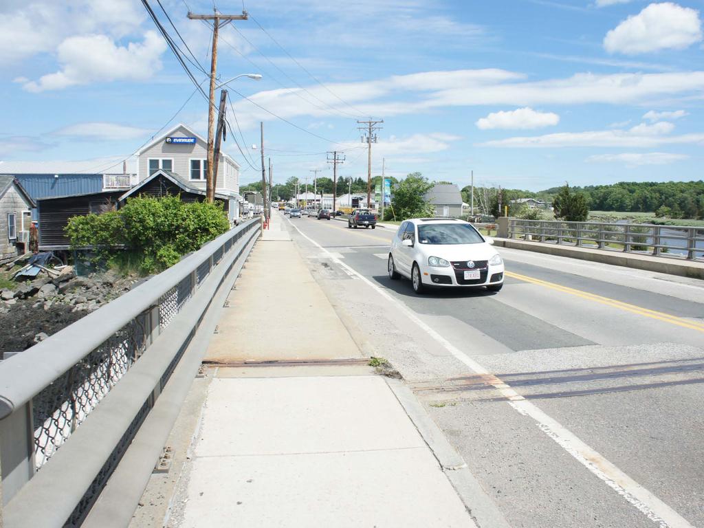
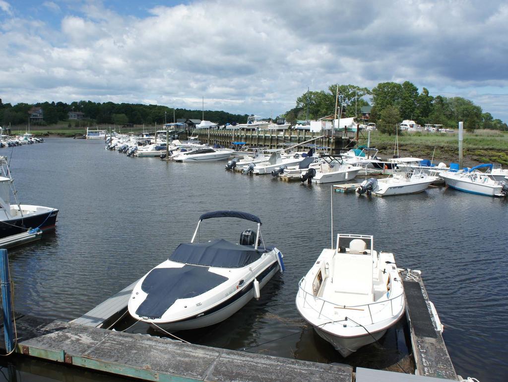
6 Background and Understanding The Town of Essex is located 30 miles north of Boston on Massachusetts North Shore. The Essex River runs through the Town Center and feeds Essex Bay. With about 3,500 residents, the Town is less populated than others nearby, but it draws a significant number of regional and local visitors. Seafood, waterfront tourism, and the flourishing antiques trade in Essex Center attracts significant visitor traffic, especially in the summer months. Restaurants such as Woodman s have customers waiting in lines in the summer that often stretch out onto the street. The Essex Marina, located in the Town Center, serves boaters across the region, and provides docking, storage, and parking for a wide variety of maritime uses. Driving is the primary mode for travelers to Essex, but parking can be confusing. The primary roads into town are Route 133 from the Northwest and Southeast, Route 22 from the Southwest, and Southern Avenue from the South. No permanent fixed route transit serves Essex; however, a summer shuttle does provide limited weekend service to the nearby Commuter Rail station in Ipswich. Additional Commuter Rail service is available in Manchester-by-the-Sea, 5 miles to the south. Route 133, the Town s Main Street, is a MassDOT owned road. Shoulders on this road vary in width with no parking regulations, creating a confusing situation for visitors and enforcement officials alike. While much of the town s off-street parking is privately owned, business owners have relied on informal shared parking agreements to balance customer demand. Recently, town officials have made strides to improve the built environment. This includes a town wide Essex Village Initiate in 2009 and a 5-year Strategic Plan in The Town also looked at how to improve the walking and landscape environment around Town Landing through a Town Landing improvement Plan in 2013, and it explored the feasibility of a Town boardwalk to increase public accessibility to the Essex River through a study in In the context of additional local planning initiatives, the Town conducted this comprehensive parking study to unlock potential for local development, enhance visitor access, and better accommodate the parking needs of both visitors and residents. An effective parking management plan can maximize existing Town resources and provide important data to support future initiatives. In addition, it gives local residents and business owners a forum to express concerns and solutions for improving access and mobility town-wide. The study is multimodal in nature and examines issues not only related to vehicle parking management, but possibilities to improve access for pedestrians, bicyclists, and potential transit connections. 6

7 ESSEX CENTER PARKING STRATEGY 7
8 Existing Conditions

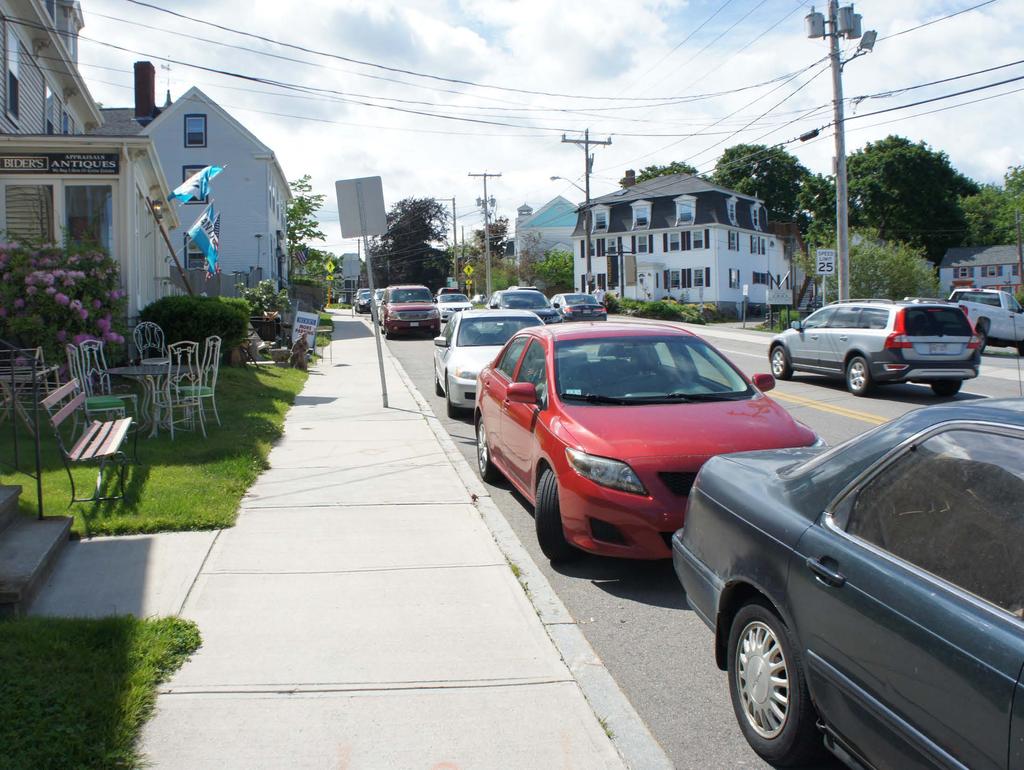
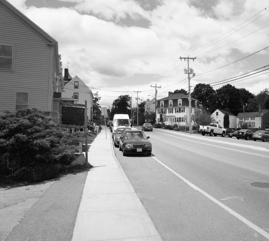
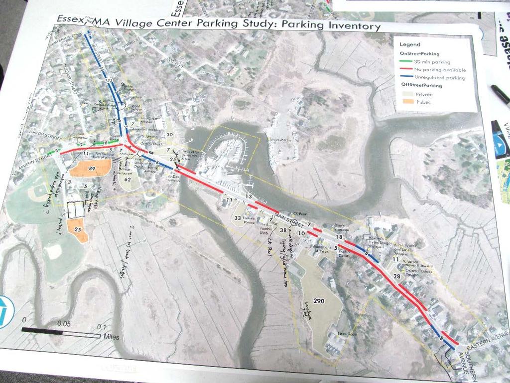
9 Existing Conditions This section documents the existing parking conditions in Essex Center. Data collection efforts in the Summer of 2016 identified existing parking assets, their regulation, how they are used today, and the Town s current parking management strategies. STUDY AREA In order to effectively measure parking usage across the town center, a study area was identified that includes a portion of Main Street from Western Avenue to Southern Avenue and part of Martin Street from Main Street to Shepard Drive. The defined study area also includes the Town Landing and major local and regional attractions such as restaurants and antique stores. The study area encompasses many private lots serving local businesses, along with one municipal lot west of the Town Center. Most businesses rely on the limited on-street parking or their own parking lot, but informal agreements exist to share parking between businesses to support those with limited on-site parking supply. On-street parking exists in places along Martin Street (State Route 22) and Main Street (State Route 133), but it is mostly unmarked within a wide shoulder with unclear regulations. Figure 1: Essex Center Study Area & Parking Inventory Note: Detailed inventory map in the Appendix. ESSEX CENTER PARKING STRATEGY 9
10 Existing Conditions PARKING INVENTORY Based on a field inventory conducted in June 2016, there are approximately 840 public and private parking spaces in the Essex Town Center study area. As shown in Figure 2, the vast majority of the parking supply approximately 75% is privately owned and is restricted to designated users, such as customers or employees. Nearly 300 spaces, or about 35% of the total supply in the Town Center, are in the privately-owned Woodman s lot. The owner informally allows other patrons to park there without penalty. On-street parking supply is very limited, and the regulation and legality of certain spaces is unclear. The full parking inventory is depicted in the parking regulations map in Figure 1. Other key findings from the inventory are shown below. Figure 2: Parking Inventory in Essex Center Parking Location # of Spaces Percentage % Publicly Available % Restricted Access On-Street 89 11% 100% 0% Off-Street 747 (Public: 117 Private: 630) Total % Parking Regulation 89% 16% 84% Parking Inventory Key Findings There are approximately 840 existing parking spaces in the study area, but only 11% are on-street. Out of the 90 on-street parking spaces, most are unregulated and unmarked; a few spaces along Martin Street have 30-minute limits. The only publicly-owned parking is west of the Town Center, off of Martin Street, behind the Fire Station. A majority (84%) of the 750 off-street parking spaces are privately-owned and restricted to specific user groups. 10
11 Existing Conditions PARKING UTILIZATION Parking occupancy counts provide a time series of typical parking demand at different times of day in an area. To gather this data, the team counted parked cars in each on-street segment and every off-street facility at pre-determined time intervals. By compiling parking utilization spatially, one can begin to clearly identify patterns of high or low usage, see the impact of regulations, and assess how much of the parking supply is actually utilized throughout a typical day. Land usage, regulations, pricing, and signage can drastically impact how even adjoining parking assets are utilized. In order to ensure that parking management systems are operating efficiently, a certain level of vacancy and utilization is preferred both on-and off-street. It is ideal to have at least one empty on-street space per block face in a downtown, ensuring easy customer access to businesses. This typically equates to about 1 out of 8 spaces free, or a target of 15-percent vacant per block face. Similarly a goal of at least 10-percent vacancy is considered ideal in off-street lots. If any facility has less availability, it is effectively at its functional capacity and drivers perceive parking problems. Facilities with lower utilization have excess capacity. The study team conducted parking occupancy counts on a typical weekend in the summer to capture the peak seasonal demand of the year. Utilization counts were conducted on a sunny Saturday in mid-july from 12pm until 8pm (from lunchtime to dinner time peak) to understand parking demand associated with Essex Center s peak activities. Spatial Analysis of Parking Utilization: General Analysis A chart of hourly utilization rates for one specific location is valuable, but seeing how that location behaves among others located nearby can reveal patterns and trends not evident in numbers alone. The lot which is completely full may be right around the corner from another lot that has plenty of availability at the same time. Using the occupancy data, the study team developed a series of maps showing the utilization of each facility over time. Color represents the percentage of spaces utilized at each location based on notable breaks used to evaluate the adequacy of a parking facility: Light Blue, Blue, and Yellow represent 0-80% utilization, a point at which street faces and off-street facilities are viewed as underutilized. Any resource that consistently performs at this level, especially during peak-demand periods, can be viewed as having excess capacity. Orange signifies blocks and facilities with 81% to 90% utilization, and represents actively-used resources. Particularly for off-street facilities, the nearer utilization levels approach the high end of this range, the more efficiently they are being utilized. Red denotes utilization above 90% and is considered to be functionally full. These blocks and facilities appear full to motorists and consequently give the impression of an overall lack of parking. ESSEX CENTER PARKING STRATEGY 11


12 Existing Conditions PARKING UTILIZATION Parking utilization counts were conducted on a typical summer Saturday between 12:00 p.m. and 8:00 p.m. Data collectors captured parking demand for 8 hours with counts every two hours in the study area. On the right are the key findings for Saturday parking utilization, followed by the spatial analysis maps on the next page which show the spatial patterns of parking utilization in two key periods: from 12:00 p.m. to 2:00 p.m. and from 6:00 p.m. to 8:00 p.m. These hours were chosen to capture customer, retail, and residential activity within Essex Center in peak summer beach and dining hours. Additional data collection was conducted by town staff on weekday evenings to validate the utilization patterns, which remained similar with only lower intensity. Figure 3: Parking Utilization Color Shades Parking Utilization Key Findings Overall, Essex Center has a peak parking utilization of 66% which occurs from 6:00 p.m. to 8:00 p.m. Maximum observed demand is 550 parked cars in the study area. On-street parking is 53% full at its peak time between 4:00 p.m. and 6:00 p.m. Off-street parking peaks at 6:00 p.m. to 8:00 p.m. with a peak demand of 71% full, leaving approximately 220 spaces empty. Private lots are more heavily used than the municipal lot throughout the day. The municipal (paved) lot is most utilized between 2:00 p.m. and 4:00 p.m., with a peak demand of 53%.* Private lots are over 60% full after 2:00 p.m. and reach a peak demand of 78% in the evening after 6:00 p.m. Among them, Woodman s 290-space lot is 83% full in the evening, and the Village Restaurant s parking lot also gets full at dinner time. Including both on- and off-street parking, out of all publicly-available supply, 52% is full at peak, leaving almost 100 empty spaces. Note: Illegal parking indicates cars parked on-street in areas where parking is not allowed by sign, or street marking. * Note: Trucks towing trailers were counted as two cars due to their occupancy of two normal parking spaces. 12

13 Figure 4: Essex Center Parking Utilization Saturday July 16th 12pm-2pm Figure 5: Essex Center Parking Utilization Saturday July 16th 2pm-4pm Figure 6: Essex Center Parking Utilization Saturday July 16th 4pm-6pm Figure 7: Essex Center Parking Utilization Saturday July 16th 6pm-8pm Note: Detailed utilization maps in the Appendix. Note: Detailed utilization maps in the Appendix. ESSEX CENTER PARKING STRATEGY 13
14 Existing Conditions PARKING UTILIZATION The utilization charts show a detailed picture of parking occupancy and vacancy. The green bars indicate how many cars are parked in each time period; the grey areas indicate the number of available parking spaces. Based on the detailed data collection effort, the utilization data can be analyzed in multiple ways, such as by regulation, location, or type of parking. This analysis reveals that parking demand is not uniform throughout the study area. Overall, Essex Center s parking supply is under 70% utilized, indicating an adequate availability throughout the day. Offstreet private lots are proportionately more utilized than onstreet and municipal lots. Figure 9: Utilization Profile: On-Street Parking Figure 8: Utilization Profile: All Parking Within The Study Area Saturday Utilization 100% 80% 60% 40% 20% Occupied Vacant % 12-2PM 2-4PM 4-6PM 6-8PM Figure 10: Utilization Profile: Off-Street Parking Saturday Utilization Saturday Utilization 100% 80% 60% Occupied Vacant % 80% 60% 428 Occupied Vacant % 20% 0% PM 2-4PM 4-6PM 6-8PM 40% 20% 0% PM 2-4PM 4-6PM 6-8PM Note: The red dotted line indicates the 90-percent optimal occupancy 14
15 Existing Conditions Figure 11: Utilization Profile: All Publicly-Available Parking (On- & Off-street) Saturday Utilization Figure 12: Utilization Profile: Off-street Private Lots Saturday Utilization 100% 80% 60% Occupied Vacant % 80% 60% 369 Occupied Vacant % 20% 0% PM 2-4PM 4-6PM 6-8PM 40% 20% 0% PM 2-4PM 4-6PM 6-8PM Figure 13: Utilization Profile: Town Center Municipal Lot (paved) Saturday Utilization 100% 80% 60% Occupied Vacant Figure 14: Utilization Profile: Woodman s Lot Saturday Utilization 100% 80% 60% Occupied Vacant % 20% % 20% % 12-2PM 2-4PM 4-6PM 6-8PM 0% 12-2PM 2-4PM 4-6PM 6-8PM Note: The red dotted line indicates the 90-percent optimal occupancy ESSEX CENTER PARKING STRATEGY 15

16 Public Process
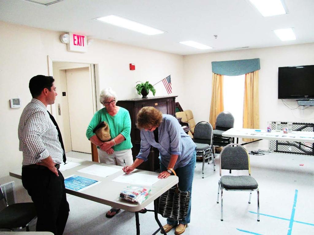
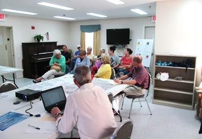
17 Public Process The public outreach process is an integral piece of the parking analysis, as it can help unlock another level of understanding of how parking is used or not used and the reasons why. In addition to parking data collection, the study team conducted a series of stakeholder meetings, facilitated a public open house in June 2016, and launched an online parking user survey between May and July in 2016 all done in order to understand and represent the community perspective of parking in Essex Center. STAKEHOLDER INTERVIEWS A series of targeted stakeholder interviews were conducted at the early stage of the public outreach process to gather input from those most familiar with parking issues and challenges in Essex Center. Town staff identified and invited stakeholders including business owners, developers, institutions, parking administration staff, and Town planning staff. The primary goal of these small-group meetings was a free flowing exchange about parking and an understanding of specific parking experiences and perspectives in Essex Center. Several common themes emerged, which are summarized at right. Interviewed Stakeholders Steering Committee Westley Burnham Susan Coviello Brendhan Zubricki Peter Silva Robert Coviello Property owners/merchants Town parking staff Town planner, policy and administration staff Key institutions Paul Goodwin Matt Coogan Kim Drake Lisa O Donnell Stakeholder Interview Summary Conflict exists between employee and customer parking. Summer weekends are the busiest time for parking. Existing parking spaces should be formalized and regulated by striping and enforcement, e.g. on-street and the unpaved municipal lot behind Town Tennis Court. Striping and formalizing on-street parking requires coordination between the Town and the State. Shared parking among private owners exists and should be encouraged. Trailer parking poses challenges in the municipal lot. Directional and parking signage is generally needed. A more walkable and bikable downtown is desired. Crossing Main Street can be quite challenging with speeding through-traffic, poor visibility at turning corners, and improperly-placed crosswalks. Bicycle parking and infrastructure is needed. Residents complain of others parking on their street. Short-term loading zones are needed for antique stores. Valet parking for stores and restaurants at peak time may help relieve parking pressure. ESSEX CENTER PARKING STRATEGY 17
18 18

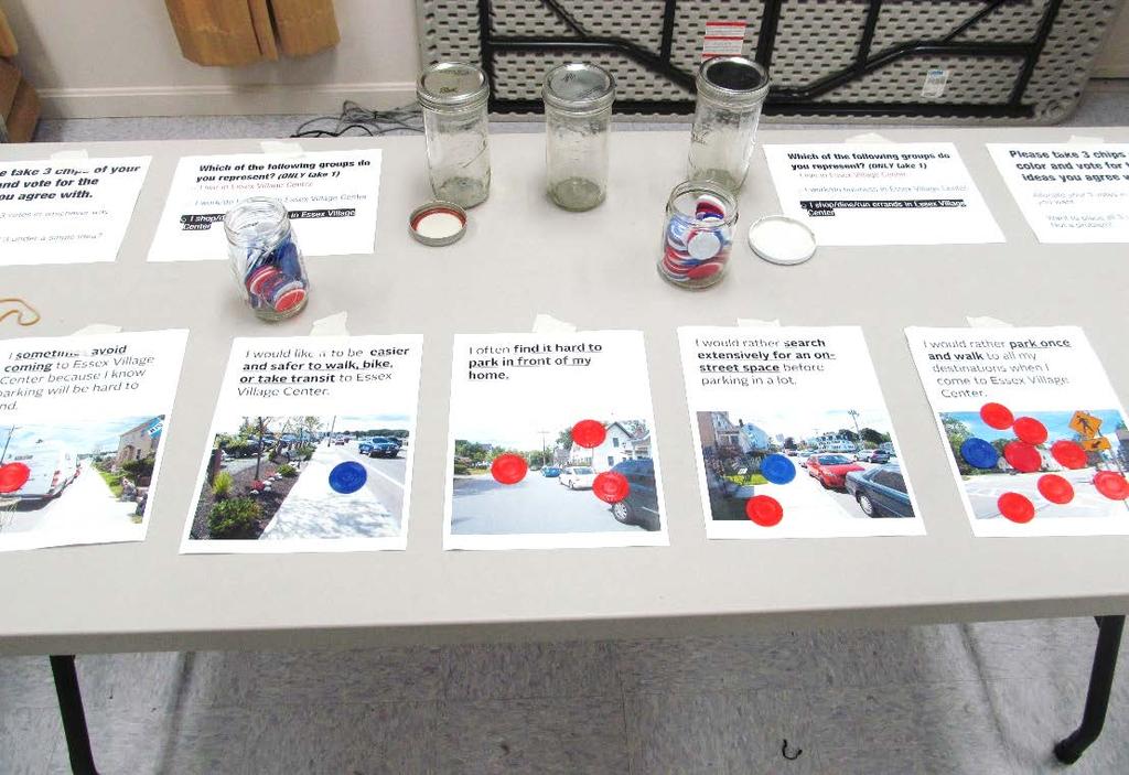
19 Public Process OPEN HOUSE On June 28 th 2016, local residents, business owners, employees and others were invited to Essex Senior Center to participate in a hands-on parking Open House designed to gather input on parking in Essex Center. The Open House included a brief presentation of the study background and initial findings through field observation and online survey. A majority of the meeting time was used to gather feedback from the public through a number of interactive activities and an open comments period for participants to express their concerns directly to the study team. More than a dozen public participants showed up and voiced their comments and concerns. Figure 15: Open House Flyer (June 2016) Open House Key Findings Participants prefer to park once and walk to all their destinations in downtown Essex. Participants also expressed that it was sometimes difficult to park in front of their own home and stated a preference for on-street parking versus off-street parking Many pointed out hazardous locations in Essex Center for pedestrians crossing the streets. Many stated that they find the current configuration of on- and off-street parking confusing, and believed that better signage, markings and information was needed. Generally, participants agreed that long-term parking should be placed further from the town center and that high parking turnover in the town center was important to increase business. Shoulder parking along Main Street is confusing in terms of legality and regulation. Traffic speeding, truck and through traffic has created an unsafe and unpleasant walking environment along Main Street. Participants suggest clearer regulation on resident and non-resident parking with trailers. ESSEX CENTER PARKING STRATEGY 19

20 Public Process Figure 16: Parking Priority Exercise Results Parking Priorities Voting Exercise Open house participants were invited to vote for the parking-related priorities that were of greatest concern to them. With five potential priorities, participants were allotted three votes that could be used to prioritize one of more issues. The exercise revealed a local desire (53%) for a more walkable downtown in a park-once zone. This response indicates that there are types of infrastructure that could be improved to encourage walking. The second most votes (20%) were received for find it hard to park in front of my home, indicating a problem with parking along residential streets 20


21 Public Process OPEN HOUSE Mapping Exercise Participants expressed directly to the study team their comments on issues and opportunities regarding parking in Essex Center. Location-specific comments were marked directly onto a large printed map of the study area, while non-location-specific comments were listed separately. All comments were compiled into the electronic version in Figure 17. Possible solutions were marked as opportunities, while comments without a clear or immediate solution were marked as issues. Figure 17: Open House Mapping Exercise Comments ESSEX CENTER PARKING STRATEGY 21
22 Public Process ONLINE SURVEY This section summarizes findings from the online parking user survey, which incorporated input from parkers regarding their parking preference, habits, experiences, and perceptions. Respondents reported about their most recent day in Essex Center along with more generalized perceptions. The online survey was launched on May 2 nd 2016 and was widely distributed and publicized on Town website and through local media. By July 15 th 2016 when the survey was closed, it had attracted over 200 responses. Figure 18: Respondents by User Group What was your PRIMARY purpose in coming to Downtown Essex today? I own a business in Downtown Essex 3% Other 10% I live in or near Downtown Essex 49% I work in Downtown Essex 5% I dine in Downtown Ess ex 13% I shop, run errands or have appointments in Downtown Essex 20% I come to use the marina in Downtown Essex 0% Online Survey Key Findings 49% of the total 216 survey respondents are downtown residents; 33% are downtown customers; 8% are downtown employers or employees, and; 10% identified as other user groups. Most survey respondents are frequent visitors to Essex Center 43% visit downtown every day, 40% several times a week. Most respondents park on Martin Street/Route 22 (37%) or a private parking lot (38%). Most respondents are short-term parkers 39% park less than 30 minutes, 17% within 1 hour. A majority of respondents (approximately 90%) can find a parking spot within 5 minutes on the day they filled in the survey or on an average day; and even on the worst day, still over half (56%) can find parking within 5 minutes. One third of the respondents at least once failed to find parking and left. A significant majority (96%) of survey respondents are not willing to pay to get a guaranteed parking space. On the question of what would enhance the transportation and parking experience in Essex Center, most think info and signing about parking options in the area would help parkers navigate; and better walking conditions, and more bicycling infrastructure/parking are desired. 22
23 Public Process ONLINE SURVEY Figure 19: Most Survey Respondents are Frequent Visitors How often do you come to Downtown Essex? A few times a year or less 1% Several times a month 16% Several times a week 40% Every day 43% Figure 21: Most Respondents Park on Martin Street or in a Private Lot Today, or the most recent day you drove to Essex, where did you park? In another private parking lot 26% On Martin Street/Rt % Figure 20: Most Survey Respondents are Short-Term Parkers How long do you typically park in Downtown Essex? 4 to 8 hours 5% More than 8 hours 5% At the Village restaurant 5% At Woodman's 6% In the municipal lot (south of Martin Street) 13% On Main Street/Rt % 2 to 4 hours 9% 1 to 2 hours 25% 30 minutes to 1 hour 17% Less than 30 minutes 39% In the landing lot near the marina 1% On Pickering Street 4% On Winthr op Street 0% ESSEX CENTER PARKING STRATEGY 23
24 Public Process ONLINE SURVEY Figure 22: Some Who Can t Find Parking Will Leave Have you ever failed to find parking and just left? Figure 24: Preference of Transportation and Parking Improvement In your opinion, what would enhance the transportation and parking experience in Downtown Essex? Yes 32% More info and signing about parking options in the area 14.38% 43.79% 41.83% No 68% Better walking conditions 23.33% 33.33% 43.33% More bicycling infrastructure/parking 34.01% 34.69% 31.29% Figure 23: Little Desire to Pay for Parking Would you be willing to pay to get a guaranteed parking space in downtown? More on-street parking available near the front door of my destination % 37.93% 25.52% Yes 4% More off-street parking, even if priced 42.67% 42.00% 15.33% Better transit options 48.18% 33.58% 18.25% No 96% 0% 20% 40% 60% 80% 100% Responses No benefit Moderate benefit Significant benefit 24

25 ESSEX CENTER PARKING STRATEGY 25
26 Recommendations

27 Recommendations The study has identified that Essex Center s parking system currently meets the needs of its diverse retail, commercial and recreational uses, as well as day-to-day resident, employee, and visitor needs. A majority of parking remains underutilized throughout the course of the day, except that several retail stores and restaurants who have smaller lots onsite get busy during peak dining hours in the summer. The main challenges for Essex Center are its limited on-street parking resources and a challenging walking environment for accessing many remote parking resources. A comprehensive parking study is an opportune time for the Town to improve its current parking management system to help support downtown businesses and future mixed-use development. The following recommendations are intended to serve as guidance for the implementation of changes to Essex Center s parking management system. These recommendations reflect the conclusions of the study team, observations of the downtown environment, review and analysis of various Town data, and most importantly, input from the participants of the public open house. These suggestions are also informed by parking management best practice as evidenced in a number of similar communities across America that recognize one important point: poorly managed parking spaces constrain economic opportunity for local merchants and business owners, while good parking management supports thriving downtowns. Full implementation of these recommendations will not be possible without continued Town and private business/landowner coordination and conversation as each has a common interest and commitment to improving parking in Essex Center. Recommendations Maximize Existing Parking Resources Formalize on-street parking Increase efficiency of public off-street parking Use time-limits and clear signage to regulate parking Support Downtown Business Through Sharing Initiate public and private shared parking agreements Encourage shared parking between businesses Explore opportunities of valet parking and loading Enhance Downtown Experience Provide better parking information and signage Strategically locate crosswalks and improve safety Install missing sidewalks and minimize driveway cuts Improve event parking management during summer ESSEX CENTER PARKING STRATEGY 27

28 Recommendations Figure 25: Recommendations Overview 28


29 1. Maximize Existing Parking Resources 1A. Formalize On-Street Parking On-street parking is essential for local businesses, allowing customers to park immediately outside their destination for quick visits up to a couple hours. The provision of on-street parking also offers drivers more options and greater flexibility than with off-street parking alone. However, in Essex, on-street spaces needs to be clearly marked and have understandable regulatory signage. On-street parking should be formalized in Essex Center to improve parking options along Main Street, where there is little available parking, particularly east of Martin Street. Parking along Main Street should be managed using customer-friendly time-limits (such as 2- hours) that encourage long-term parkers to go off-street. Existing 30- minute time-limits should be maintained for the on-street parking across from the Post Office. These regulations should be clearly marked with consistent signage. For Essex Center, the ideal on-street parking space design is like the north side spaces just east of Woodman s of Essex, which provide sufficient room for parked vehicles while not impeding the flow of vehicles. Vehicle parking on the south side of Main Street west of Southern Avenue should be improved similarly by adding additional spaces and using a tapered curb extension that maintains a 30 twoway street with shoulders, until the curb t0 curb distance widens to 35 above which on-street parking can comfortably occur. Similar provisions can be made on Main Street just west of the river bridge, where there is little protection for south side parking, and also on Main Street west of Martin Street. Formalizing parking and No Parking regulations in this area will help discourage drivers from parking in areas where sightlines are compromised such as just east of Burnham Court while encouraging business access where it is not in conflict with through traffic.* * Note: MassDOT has not formally allowed parking on Route 133. ESSEX CENTER PARKING STRATEGY 29

30 1. Maximize Existing Parking Resources 1B. Increase Efficiency of Public Off-Street Parking In addition to formalized on-street parking, off-street parking in Essex Center must be improved and made to operate more efficiently in order to provide better parking opportunities for all visitors to the area. To begin, the parking lot behind the tennis courts and next to the Memorial Field baseball diamonds should be have some minimal design treatments using natural materials such as landscaping, stones, or timbers to clearly designate rows that vehicles should park in, increasing convenience while maximizing the potential capacity of the lot. Complimented by clear wayfinding and regulatory signing, this lot could become the long-term parking area for Essex Center, with up to 72-hours of storage for boat-trailer parking. While boaters would need to walk another minute or two further to the Town s boat landing, improvements to the pedestrian path could be constructed in order to facilitate the walking trip. The existing stairs to the municipal lot behind the Post Office terminate in the Village Restaurant s parking, making this connection very unfriendly. Basic signing, markings, and lighting improvements would increase the utility of the municipal lots and improvements could work to enhance the customer experience at the Village Restaurant as well, as suggested in later recommendations. In addition to the improvements described above, the Town should update the regulations of the paved municipal lot. Time-limits should be formally signed to allow a vehicle to remain for up to 10 hours, with longer parking allowed only in the unpaved lot. 30


31 1. Maximize Existing Parking Resources 1C. Use Time-Limits and Clear Signage to Regulate Parking Signage and parking regulations are crucial elements of parking management. Having clear guidance for patrons who are unfamiliar with the area is a important component of the customer experience. Highlighting existing on- and off-street spaces will improve visibility for motorists seeking parking. Overall, signage should work to eliminate confusion and ensure that all users understand the rules and locations of parking. Existing parking wayfinding signage for drivers in Essex Center is scarce and sometimes hard to find. Parking signage in both public and private lots is often hard to distinguish and may not be clear to visitors where they are allowed to park and for how long. Meanwhile, there are no pedestrian-scale signs at all to direct visitors to and from their parking space. The Town should create a robust vehicular and pedestrian parking wayfinding system to identify parking resources and key destinations in the area. Signs could be attractively branded and offered to private owners whose lots are regularly open to public customers especially where regular sharing is in effect. Parking signage should clearly indicate where the public is welcome and lay out any time-limits. The Town should implement simple regulations with clear signage to show where there is 30-minute, 2-hour, 10-hour, or 72-hour time-limits. Wayfinding signage should clearly inform drivers as to where they can find off-street parking areas, both short-term and longterm. ESSEX CENTER PARKING STRATEGY 31

32 2. Support Downtown Business through Sharing 2A. Initiate Public-Private Shared Parking District In order to expand the availability of public parking and balance the underutilization of private parking in Essex Center, the Town can create a shared parking district. Within the shared parking district, a separate set of parking standards would be created. These zoning changes would not require new developments to build as many parking spaces as previously required, and existing properties could safely bank their existing space count for future redevelopment before agreeing to open their spaces to other users. Further these changes would allow and encourage land owners and businesses to cooperate in order to provide sufficient parking at peak hours for the public. It is also recommended that Essex: Encourage the sharing of parking facilities between public and private parking areas; Lease private parking for sharing, with the Town either directly leasing spaces or acting as agent between two private entities and offering maintenance services; and Utilize existing supply before investing in more parking Further shared parking agreements could be made with places like Woodman s in exchange for Town improvements to parking lots, including upgraded landscaping, striping, lighting and signage. 2B. Encourage Shared Parking Between Businesses The Town should push for more parking agreements between Essex Center businesses. Today, informal shared parking agreement already exists with Woodman s lot as they allow other business patrons to park at peak time. The Town can facilitate these agreements between potential partners by supplying appropriate legal mechanisms and providing liability education. The Town also can support the continued sharing of parking in the event of a change of ownership or use. The Town should work to clarify with markings and signs the allowed egress across the Village Restaurant s parking lot to the stairs down to the public lot (which could one day be opened in the winter if an accessible switchback ramp were installed alongside). In exchange for improving this access to the municipal lot, the Town could offer to redesign and repave the Village s lot to increase circulation and parking as shown on the next page. 32

33 2. Support Downtown Business through Sharing Potential Village Restaurant Parking Lot Improvements Existing Proposed A reconfiguration can improve circulation and safety while increasing supply. ESSEX CENTER PARKING STRATEGY 33


34 2. Support Downtown Business through Sharing 2C. Explore Opportunities of Valet Parking and Loading Within Essex Center, some antiques businesses do not have on-site parking, and they have suggested having a short-term loading zone on the street to help their customers load furniture. Meanwhile some of the restaurants do not have enough on-site parking, and there may be an opportunity to use valet parking with a combination of a shared parking agreement among businesses to improve parking in the area. In order to accommodate customer parking, the Town can create a public valet program in order to better accommodate public parking demand. By linking just a few on-street spaces used for drop-off and pick-up to under-utilized off-street facilities, public valet can expand curbside parking resources in high-demand areas, at high-demand times, and make greater use of all area parking resources. For customers, these services offer an easy alternative to finding parking by allowing drivers to drop-off their car at a convenient location. Essentially, it combines the convenience of on-street parking with the expansive capacity of off-street facilities. Valets can operate on tips donated to charitable causes. Examples of graphics/photo A public valet can also help facilitate shared parking arrangements, by limiting access to the shared facility to an identifiable service operated by a party that can assume responsibility for all risk. This can open up access to private parking lots that might otherwise remain significantly under-utilized or to lot owners that are resistant to providing more open access to their facilities. Meanwhile, the Town can further improve on-street parking and parking demand in the area by creating time-limited loading zones in the area. These loading zones would be placed near the antique stores along Main Street and would help alleviate congestion along Main Street caused by double-parked vehicles that load or unload antiques. 34

35 ESSEX CENTER PARKING STRATEGY 35


36 3. Enhance Downtown Experience 3A. Provide Better Parking Information and Signage Many visitors to Essex Center particularly out-of-town visitors are unaware of empty parking spaces located within the area and nearby their destination. Signage that guides motorists to on-and off-street parking deters drivers from excessive cruising and frustration. Parking and wayfinding signage that is easy-to-read and understand is a critical component to deciphering a downtown and its parking system. A wayfinding program should encourage a park once or park and walk environment, focusing not just on getting cars into parking facilities but getting people to visit multiple destinations on foot without moving their cars. In addition to parking facilities, signage should identify key sites of interest and their approximate walking distance (in minutes), such as area businesses, the Town Landing, municipal buildings, and other points of interest. Signage for parking and information should be a part of a comprehensive strategy to inform visitors before they arrive, at their arrival, and during their stay in Essex. Information should be available before a visitor s trip to Essex through the Town s website and other tourist outreach materials that demonstrate where on- and 0ff-street parking is available. When a visitor arrives in Essex, signage should clearly point to parking and nearby destinations. Finally, during their stay, visitors should be able to easily navigate the area using signage that shows the way to destinations and back again to parking areas. Having free maps available to visitors in shops and other public places will further improve access to relevant information and may reveal new destinations to visitors. The team recommends installing wayfinding signage to guide those new to Essex or those that only come once or twice a year. Using street names to rename and brand the municipal parking lots based on their location also can go a long way to making the system more accommodating. 36


37 3. Enhance Downtown Experience 3B. Strategically Locate Crosswalk and Improve Safety Crosswalks are natural points of conflict between vehicles and pedestrians. While crosswalks are used by pedestrians, they are designed to warn drivers. Advanced signage, yield triangles or sharks teeth, and broad, reflective crosswalk bars are all designed not simply to direct the pedestrian but to inform the driver of possible conflicts and to prepare to yield to someone walking. Essex s crosswalks are often not designed with the best pedestrian-oriented designs in mind. Most Essex crosswalks use thin, diagonal zebra striping as seen on the following page. With the addition of horizontal lines that can be confused with stop bars, plus the short depth of the lines, the crosswalks are difficult to see from far enough in advance for motorists to be safely warned at prevailing speeds. All crosswalks in Essex Center should conform to best practice; ideally 1-2 thick continental ladder bars that run parallel to traffic. These bars should be a minimum of 16 long, rather than the 8-10 length that they are today. Appropriate crosswalk signs should be included, and advanced yield shark s teeth should be installed 30 before each crosswalk where a stop sign is not installed. Further improvements can be made at intersections within the Essex Center area to improve safety for people who are walking. Potential improvements suggested on the following pages include: the intersection of Martin and Main Streets, the crossing at Willow Court, pedestrian upgrades at Southern Avenue and Main Street, and other improvements, including: New crosswalks on Main Street in the following places: Immediately west of the river bridge, just east of the on-street parking East of Woodman s, terminating the north side on-street parking with a curb extension Before the south side spaces at their protecting extension Improve the existing crosswalk west of Woodman s ESSEX CENTER PARKING STRATEGY 37

38 3. Enhance Downtown Experience Intersection of Main Street and Martin Street - Before 38
39 3. Enhance Downtown Experience Intersection of Main Street and Martin Street - After ESSEX CENTER PARKING STRATEGY 39
40 3. Enhance Downtown Experience Intersection of Main Street and Southern Avenue - Before 40

41 3. Enhance Downtown Experience Intersection of Main Street and Southern Avenue - After ESSEX CENTER PARKING STRATEGY 41


42 3. Enhance Downtown Experience 3C. Install Missing Sidewalk & Minimize Driveways In order to provide a comprehensive parking improvement plan in Essex Center, attention must be paid to the walking experience to and from parking. Notable walkability issues in the area include a lack of sidewalks in key areas and frequent driveway curb cuts. Both of these issues limit walkability, increase conflict areas between vehicles and people walking, and lower the quality of the visitor experience. As shown earlier, the Town should remove redundant curb cuts at the Town Landing, and combine the multiple curb cuts into one driveway for the businesses, boat ramp, and shipbuilding museum, rather than the three that exist there today. A sidewalk should be installed on the southeast side at the end of Martin Street, as shown below. This sidewalk can additionally operate as a raised driveway lip in order to permit the continued use of existing head-in off-street parking along Martin Street, however curb extensions should be added for the two crosswalks. 3D. Improve Summer Event Parking Management Event management programs are designed to allow towns to better leverage and manage parking facilities during large events. Using such a system, a town can prevent excessive parking on residential streets proximate to the event site and find partners to share reserve supply for patrons, especially during after-work hours. For events that occur regularly, such as sports events, concerts, or festivals, a town can create parking districts that allow for certain parking designations on public streets, such as resident-only, vendors-only, or temporary public parking. Essex should improve the parking management system during events, when infrequent guests are most likely to come to the Town Center. Strategies to improve the visitor parking experience in the area include supplemental signage for remote parking, and event/sunday antiquing parking information via websites, postcards, and signs. Information should include guidance to parking in remote areas such as the unpaved lot near the ballfields. 42
43
44 TECHNICAL APPENDICES

45 APPENDIX A Appendix Figure 1: Essex Center Study Area Parking Inventory

46 APPENDIX A Appendix Figure 2: Essex Center Parking Peak Utilization Saturday July 16th 12pm-2pm
47 APPENDIX A Appendix Figure 3: Essex Center Parking Peak Utilization Saturday July 16th 2pm-4pm
48 APPENDIX A Appendix Figure 4: Essex Center Parking Peak Utilization Saturday July 16th 4pm-6pm
49 APPENDIX A Appendix Figure 5: Essex Center Parking Peak Utilization Saturday July 16th 6pm-8pm

50 APPENDIX A Appendix Figure 6: Open House Mapping Exercise Comments
51 APPENDIX A Appendix Figure 7: Recommendations Overview
52

53 NELSON\NYGAARD CONSULTING ASSOCIATES 2016
Outreach Approach RENEW SF served as the primary liaison with the North Beach community; the Chinatown. Executive Summary
 Executive Summary Executive Summary The Columbus Avenue Neighborhood Transportation Study s objective is to identify changes to transportation infrastructure and policies that could enhance the livability
EXECUTIVE SUMMARY. A Executive Summary
 EXECUTIVE SUMMARY The Monroe Avenue Parking and Mobility Study was initiated to provide a comprehensive assessment of existing parking and mobility conditions along the Monroe Avenue corridor from the
PEDESTRIAN ACTION PLAN
 ATTACHMENT 2 CITY OF SANTA MONICA PEDESTRIAN ACTION PLAN CITY OF SANTA MONICA PEDESTRIAN ACTION PLAN This page intentionally left blank EXECUTIVE SUMMARY CHAPTER 1 EXECUTIVE SUMMARY Setting the Stage
TRAVEL PLAN: CENTRAL EUROPEAN UNIVERSITY CAMPUS REDEVELOPMENT PROJECT TRAVEL PLAN. Central European University Campus Redevelopment Project.
 TRAVEL PLAN Central European University Campus Redevelopment Project Page 1 Table of Contents Introduction... 3 Background... 7 Building Users... 7 Transportation in Community Consultation... 7 Summary
Grove Hall Business District Parking Analysis
 Grove Hall Business District Parking Analysis February 2014 Prepared for The Roxbury Great Neighborhoods Partnership Nuestra Comunidad Development Corporation Dudley Square Main Streets Greater Grove Hall
East Burke Transportation, Safety and Capacity Improvements
 East Burke Transportation, Safety and Capacity Improvements The purpose of this project is to increase mobility and improve safety for pedestrians, cyclists, and motor vehicles along VT Route 114 in the
Cherry Creek Transportation and Land Use Forum September 25, 2013 Meeting Summary
 Cherry Creek Transportation and Land Use Forum September 25, 2013 Meeting Summary I. LEAD-IN TO SMALL GROUP DISCUSSION, POLLING AND STEERING COMMITTEE/TECHNICAL TASK FORCE DISCUSSION The meeting began
o n - m o t o r i z e d transportation is an overlooked element that can greatly enhance the overall quality of life for the community s residents.
 N o n - m o t o r i z e d transportation is an overlooked element that can greatly enhance the overall quality of life for the community s residents. 84 Transportation CHAPTER 11 INTRODUCTION Transportation
EXECUTIVE SUMMARY. Vision
 Vision Walking and bicycling in Salt Lake City will be safe, convenient, comfortable, and viable transportation options that connect people to places, foster recreational and economic development opportunities,
MEMORANDUM. Existing Operations. City of Clearwater. Michael Herrman. Date: January 26, Seminole Boat Launch Overview. M&N Job No.
 1509 W. Swann Avenue, Suite 225 Tampa, FL 33606 (813) 258-8818 Fax (813) 258-8525 www.moffattnichol.com MEMORANDUM To: From: City of Clearwater Michael Herrman Date: Subject: Seminole Boat Launch Overview
Proposed. City of Grand Junction Complete Streets Policy. Exhibit 10
 Proposed City of Grand Junction Complete Streets Policy Exhibit 10 1 City of Grand Junction Complete Streets Policy Vision: The Complete Streets Vision is to develop a safe, efficient, and reliable travel
APPENDIX A: Complete Streets Checklist DRAFT NOVEMBER 2016
 APPENDIX A: Complete Streets Checklist DRAFT NOVEMBER 2016 Complete Streets Checklist MetroPlan Orlando s Complete Streets Checklist is an internal planning tool for staff to further implementation of
CITY OF COCOA BEACH 2025 COMPREHENSIVE PLAN. Section VIII Mobility Element Goals, Objectives, and Policies
 CITY OF COCOA BEACH 2025 COMPREHENSIVE PLAN Section VIII Mobility Element Goals, Objectives, and Policies Adopted August 6, 2015 by Ordinance No. 1591 VIII MOBILITY ELEMENT Table of Contents Page Number
Solana Beach Comprehensive Active Transportation Strategy (CATS)
") Solana Beach Comprehensive Active Transportation Strategy (CATS) 3.0 Goals & Policies The Solana Beach CATS goals and objectives outlined below were largely drawn from the Solana Beach Circulation Element
Solana Beach Comprehensive Active Transportation Strategy (CATS) 3.0 Goals & Policies The Solana Beach CATS goals and objectives outlined below were largely drawn from the Solana Beach Circulation Element
Implementation Matrix
 Downtown Delaware Parking Study Short Term Mid Term Long Term = Within one year = Within three years = More than three years The highlighted proposed enhancements will require a substantial amount of input
Data Analysis February to March Identified safety needs from reported collisions and existing travel patterns.
 Welcome! Thank you for participating in today s Valencia Bikeway Improvements workshop. Data Analysis February to March Identified safety needs from reported collisions and existing travel patterns. Initial
City of Novi Non-Motorized Master Plan 2011 Executive Summary
 City of Novi Non-Motorized Master Plan 2011 Executive Summary Prepared by: February 28, 2011 Why Plan? Encouraging healthy, active lifestyles through pathway and sidewalk connectivity has been a focus
EUCLID AVENUE PARKING STUDY CITY OF SYRACUSE, ONONDAGA COUNTY, NEW YORK
 EUCLID AVENUE PARKING STUDY CITY OF SYRACUSE, ONONDAGA COUNTY, NEW YORK CITY OF SYRACUSE DEPARTMENT OF PUBLIC WORKS 1200 CANAL STREET EXTENSION SYRACUSE, NEW YORK 13210 DRAFT REPORT DATE: November 13,
Corpus Christi Metropolitan Transportation Plan Fiscal Year Introduction:
 Introduction: The Safe, Accountable, Flexible, Efficient Transportation Equity Act: A Legacy for Users (SAFETEA-LU) has continued the efforts started through the Intermodal Surface Transportation Efficiency
Chapter 2: Standards for Access, Non-Motorized, and Transit
 Standards for Access, Non-Motorized, and Transit Chapter 2: Standards for Access, Non-Motorized, and Transit The Washtenaw County Access Management Plan was developed based on the analysis of existing
Lee s Summit Road Improvement Study Public Open House June 7, 2007 Summary of Comment Card Responses
 Lee s Summit Road Improvement Study Public Open House June 7, 2007 Summary of Comment Card Responses Introduction At the Lee s Summit Road Improvement Study Public Open House held Thursday, June 7, 2007
Mainstreet Master Plan Land Use
 Mainstreet Master Plan 04 Land Use Top Recommendations Active Uses: Promote active ground-floor uses such as retail, restaurants, galleries and personal services with interactive storefronts for Mainstreet
1.0 EXECUTIVE SUMMARY
 1.0 EXECUTIVE SUMMARY The Active Transportation Plan is a guide to accomplish the Town s vision for developing a network of sidewalks, on-road bicycle facilities, and trails that allow for safe and convenient
S T A T I O N A R E A P L A N
 The Circulation and Access Plan describes vehicle, pedestrian, and transit improvements recommended within the Concept Plan. In order to create and sustain a vibrant business district that provides pedestrian-friendly
Bicycle Master Plan Goals, Strategies, and Policies
 Bicycle Master Plan Goals, Strategies, and Policies Mobilizing 5 This chapter outlines the overarching goals, action statements, and action items Long Beach will take in order to achieve its vision of
CONNECTING PEOPLE TO PLACES
 CONNECTING PEOPLE TO PLACES 82 EAST BENCH MASTER PLAN 07 Introduction The East Bench transportation system is a collection of slow moving, treelined residential streets and major arteries that are the
North Shore Transportation Improvement Strategy
 North Shore Transportation Improvement Strategy Preliminary, Near-term Recommendation 2016 April Transportation Improvement Strategy (TIS) Comprehensive and Analytical A multi-modal transportation strategy
4 Goals, Objectives & Actions
 Chapter4 4 This chapter presents goals, objectives, and recommended actions to support the vision of making Overland Park a safer and easier place to ride a bicycle. 35 4.1 Recommendations Structure The
Chapter 7. Transportation. Transportation Road Network Plan Transit Cyclists Pedestrians Multi-Use and Equestrian Trails
 Chapter 7 Transportation Transportation Road Network Plan Transit Cyclists Pedestrians Multi-Use and Equestrian Trails 7.1 TRANSPORTATION BACKGROUND The District of Maple Ridge faces a number of unique
INTERMODAL TRANSPORTATION PLAN
 INTRODUCTION INTERMODAL TRANSPORTATION PLAN Effective intermodal transportation implies a public policy for actively decreasing the demand for automobile trips and consequently reducing automobile related
University of Victoria Campus Cycling Plan Terms of Reference. 1.0 Project Description
 University of Victoria Campus Cycling Plan Terms of Reference 1.0 Project Description The Campus Cycling Plan, a first for the University, will provide a comprehensive and coordinated approach to support
1999 On-Board Sacramento Regional Transit District Survey
 SACOG-00-009 1999 On-Board Sacramento Regional Transit District Survey June 2000 Sacramento Area Council of Governments 1999 On-Board Sacramento Regional Transit District Survey June 2000 Table of Contents
Downtown Parking Study
 Downtown Parking Study City of Waupaca, Wisconsin Table of Contents: April 2016 2 Introduction & Community Overview 4 Stakeholder Input 6 Downtown Walkability 8 Parking Supply & Demand 16 Future Parking
Coquitlam Cross-town Bike Route Improving Bicycle Facilities in a Mature Suburban Environment
 Coquitlam Cross-town Bike Route Improving Bicycle Facilities in a Mature Suburban Environment Sarah Rocchi, Vice-President, Projects, Opus International Consultants (Main Presenter) Catherine Mohoruk,
summary of issues and opportunities
 1 summary of issues and opportunities EXECUTIVE SUMMARY CHAPTER 2: HISTORY - 3: LAND USE This first chapter is an overview of lessons learned from analysis of the existing conditions on El Camino as well
Data Analysis February to March Identified safety needs from reported collisions and existing travel patterns.
 Welcome! Thank you for participating in today s Valencia Bikeway Improvements workshop. Data Analysis February to March Identified safety needs from reported collisions and existing travel patterns. Initial
CITY OF BLOOMINGTON COMPLETE STREETS POLICY
 CITY OF BLOOMINGTON COMPLETE STREETS POLICY POLICY OBJECTIVE: The City of Bloomington will enhance safety, mobility, accessibility and convenience for transportation network users of all ages and abilities,
Vision: Traditional hamlet with an attractive business/pedestrian friendly main street connected to adjacent walkable neighborhoods
 N D. Focus Area II Vision: Traditional hamlet with an attractive business/pedestrian friendly main street connected to adjacent walkable neighborhoods Transit Road Focus Area II is located in the Hamlet
Exhibit 1 PLANNING COMMISSION AGENDA ITEM
 Exhibit 1 PLANNING COMMISSION AGENDA ITEM Project Name: Grand Junction Circulation Plan Grand Junction Complete Streets Policy Applicant: City of Grand Junction Representative: David Thornton Address:
Item to be Addressed Checklist Consideration YES NO N/A Required Description Complete Streets Guidelines
 Passaic County Complete Streets Checklist - Concept Development Project Name Item to be Addressed Checklist Consideration YES NO N/A Required Description Complete Streets Guidelines Existing Plans Have
Comments EXECUTIVE SUMMARY
 Comments 1. Under any Alternatives, MCDOT should provide better at-grade pedestrian crossing of Georgia Avenue and Forest Glen Road, including improved crosswalks with wider medians and adequate signal
Draft North Industrial Area-Wide Traffic Plan
 Summary of North Industrial and Hudson Bay Industrial Recommended Improvements Table 1. Summary of s Item Location 1 2 3 4 5 6 7 8 9 10 11 12 Millar Ave north of 51st St Super 8 Motel back lane 400 Block
CAMPUS PARKING STUDY Analysis and Alternatives Executive Summary
 S A L E M S T A T E U N I V E R S I T Y CAMPUS PARKING STUDY Analysis and Alternatives Executive Summary M a y 2 2 0 1 8 C a m p u s C o m m u n i t y S S U N e i g h b o r h o o d A d v i s o r y C o
Tuesday, September 25 th Mount Holly Municipal Complex 400 East Central Avenue 5:30pm to 7:30pm. Activity Stations o Where do you Live?
 Meeting Information Overview The public workshop for the Mount Holly Comprehensive Bicycle Plan occurred on September 25, 2018. The drop-in workshop allowed attendees to participate in a series of interactive
Section 9. Implementation
 Section 9. Implementation The transportation system is just one of many aspects that must be carefully planned to maintain and enhance the quality of living in Cecil County. The Cecil County Bicycle Plan
New Brunswick Strategic Planning Proposal
 New Brunswick Strategic Planning Proposal Proposal Title: Rutgers University Crosswalk Enhancement Project Proposal Initiator: Rutgers University Division of Administration and Public Safety Executive
Broad Street Bicycle Boulevard Design Guidelines
 Broad Street Bicycle Boulevard Design Guidelines Building from the strategies introduced in the 2013 Bicycle Transportation Plan and community input received thus far, City Transportation Staff have identified
5 Circulation & Parking
 5 Circulation & Parking Downtown Parking & Circulation Strategy. Downtown Wayne has a somewhat disconnected system of local public streets to connect downtown with the residential neighborhoods, and primary
Encouragement. Chapter 4. Education Encouragement Enforcement Engineering & Facilities Evaluation & Planning. Encouragement Chapter 4
 Encouragement Education Encouragement Enforcement Engineering & Facilities Evaluation & Planning Photo above: Children show off their ribbons at the Tour de Virginia Beach. Virginia Beach Bikeways and
Standing Committee on Policy and Strategic Priorities. Mount Pleasant Industrial Area Parking Strategy and Access Improvements
 POLICY REPORT Report Date: April 23, 2018 Contact: Lon LaClaire Contact No.: 604.873.7722 RTS No.: 9944 VanRIMS No.: 08-2000-20 Meeting Date: May 16, 2018 TO: FROM: SUBJECT: Standing Committee on Policy
Memorandum. Sunday, July 13, Saturday, July 19, 2014
 Memorandum To: David Lowin, Brooklyn Bridge Park Corporation From: Daniel Schack, AICP, PTP Date: Re: Brooklyn Bridge Park Pier 5/6 Loop Road Traffic Study Project No: 14-01-2407 At the request of Brooklyn
STONY PLAIN ROAD STREETSCAPE
 Jasper Place Revitalization Strategy: Vision The people involved in the Jasper Place Revitalization Strategy envision: Goal 1: Feeling safe in our community Create a community where feeling safe is common--where
NM-POLICY 1: Improve service levels, participation, and options for non-motorized transportation modes throughout the County.
 Transportation PRINCE WILLIAM COUNTY 2008 COMPREHENSIVE PLAN NON-MOTORIZED PLAN CONTENTS Goals, Policies, and Action Strategies Table 4 (Bike Facility Classifications and Descriptions) Table 5 (Bike Facility
Perryville TOD and Greenway Plan
 Perryville TOD and Greenway Plan Greenway Glossary Pathway: A bicycle and pedestrian path separated from motorized vehicular traffic by an open space, barrier or curb. Multi-use paths may be within the
Climate Change Action Plan: Transportation Sector Discussion Paper: Cycling
 Climate Change Action Plan: Transportation Sector Discussion Paper: Cycling ontario.ca/climatechange Contents 1. Minister of Transportation s message... 3 2. Introduction... 5 3. Sector Overview and Support
NEIGHBORHOOD TRAFFIC CALMING POLICY
 NEIGHBORHOOD TRAFFIC CALMING POLICY I. PURPOSE The City of Kent continually strives to strengthen and protect its neighborhoods by improving the quality of life in residential areas. Traffic conditions
Eastern PA Trail Summit October 1, 2018
 Eastern PA Trail Summit October 1, 2018 WHO WE ARE + WHY + WE RE * HERE * * * * * * Session Goals: Discuss how to coordinate planning and design in small, urbanized towns Consider how to develop alternative
Montford Drive Parking & Circulation Study
 Montford Drive Parking & Circulation Study Parking & Circulation Study Follow up to the Area Plan based on what we heard Purpose 1 2 3 4 To look closer and evaluate parking and network related issues (including
Plant City Walk-Bike Plan
 Plant City Walk-Bike Plan Plant City Commute Mode Share 2.2% 1.4% 2.9% Drove alone 10.2% Carpooled Public transportation (0.1%) Walked Used a Bike (0.4%) 82.9% Taxicab, motorcycle, or other means Worked
WALK- AND bike-friendly TURLOCK
 WALK- AND bike-friendly TURLOCK Ideas to Encourage Walking and Biking Benefits to the COMMUNITY Get Connected People who walk and bike have many more opportunities for casual interactions with friends
Living Streets Policy
 Living Streets Policy Introduction Living streets balance the needs of motorists, bicyclists, pedestrians and transit riders in ways that promote safety and convenience, enhance community identity, create
Tonight is for you. Learn everything you can. Share all your ideas.
 Strathcona Neighbourhood Renewal Draft Concept Design Tonight is for you. Learn everything you can. Share all your ideas. What is Neighbourhood Renewal? Creating a design with you for your neighbourhood.
WELCOME Mission-Geneva Transportation Study
 WELCOME Mission-Geneva Transportation Study Study Process and Schedule 2005 2006 Oct Nov Dec Jan Feb Mar Apr May Jun Jul Aug Sept Oct Task 2 Develop Outreach Plan Task 3 Document Existing Conditions/ Prioritize
The five potential solutions and some of their benefits and costs are listed in the following table: Ferry Patron Bike Parking Alternatives
 STAFF REPORT City Council of the City of Sausalito AGENDA TITLE: Ferry Patron Bicycle Parking Plan - Summer 2014 RECOMMENDED MOTION: Note and file informational item, no action necessary SUMMARY In April
WELCOME. Purpose of the Open House. Update you on the project. Present a draft recommended plan. Receive your input
 WELCOME Purpose of the Open House The Town of Smiths Falls has initiated the Beckwith Street Redevelopment Plan that includes the preparation of a streetscape functional design for the renewal of Beckwith
ADA Transition Plan. City of Gainesville FY19-FY28. Date: November 5, Prepared by: City Of Gainesville Department of Mobility
 ADA Transition Plan FY19-FY28 Date: November 5, 2018 Prepared by: City Of Gainesville Department of Mobility 1.0 INTRODUCTION 1.1 BACKGROUND The federal statute known as the Americans with Disabilities
BETHEL ROAD AND SEDGWICK ROAD CORRIDOR STUDY
 DRAFT PLAN City Council Meeting August 14, 2017 STUDY AREA Sedgwick Corridor State Route 160, principal arterial with Class 3 access management designation, commuter and freight route, connection to SR
MEMORANDUM. Charlotte Fleetwood, Transportation Planner
 MEMORANDUM Date: Updated August 22, 2017 To: Organization: Charlotte Fleetwood, Transportation Planner Boston Transportation Department From: Jason DeGray, P.E., PTOE, Regional Director of Engineering
5. RUNNINGWAY GUIDELINES
 5. RUNNINGWAY GUIDELINES These guidelines should be considered collectively when making runningway decisions. A runningway is the linear component of the transit system that forms the right-of-way reserved
Woodward Hill Elementary School School Safety and Operation Review
 Address: 6082-142 nd Street Surrey, BC, V3X 1C1 Site Visit: March 7, 2011 Principal Anne Mackie Report Date: November 25, 2011 Phone: (604) 594-2408 Email: Mackie_A@sd36.bc.ca The following report is one
City of Elizabeth City Neighborhood Traffic Calming Policy and Guidelines
 City of Elizabeth City Neighborhood Traffic Calming Policy and Guidelines I. Purpose: The City of Elizabeth City is committed to ensure the overall safety and livability of residential neighborhoods. One
Safe Routes to School Action Plan Aberdeen, Idaho
 Background Aberdeen, Idaho is a largely agricultural community of nearly 2,000 people and is located in the southeast portion of the state on the western edge of American Falls Reservoir. The community
Complete Streets. Designing Streets for Everyone. Sarnia
 Complete Streets Designing Streets for Everyone Sarnia Complete Streets ~ Sarnia ~ 2018 Introduction Our City is made up of a network of streets that we use to go for a walk, cycle to work, drive to the
CITY OF SAINT JOHN TRAFFIC CALMING POLICY
 CITY OF SAINT JOHN TRAFFIC CALMING POLICY VERSION: 1.0 April 10, 2012 Pedestrians, Cyclists and Motorists Sharing Street Spaces CONTENTS INTRODUCTION... 3 POLICY GOAL... 3 POLICY OBJECTIVES... 3 GUIDING
CHAPTER 7.0 IMPLEMENTATION
 CHAPTER 7.0 IMPLEMENTATION Achieving the vision of the Better Streets Plan will rely on the ability to effectively fund, build and maintain improvements, and to sustain improvements over time. CHAPTER
Chapter 5 Future Transportation
 Chapter 5 Future Transportation The Future Land Use Plan identifies the desired land use designations. The land uses desired for Crozet depend, in large part, on the success of the transportation system,
Owl Canyon Corridor Project Overview and Summary
 Owl Canyon Corridor Project Overview and Summary December 22, 2008 The Owl Canyon corridor (generally the connection between the I-25 / Larimer County Road 70 interchange and the US 287 / Larimer County
Newport City Thoroughfare Plan
 Newport City Thoroughfare Plan Summary This plan is intended to review and make recommendations for Newport City s thoroughfare network, in consideration of the full range of uses of the city s streets.
ACTIVE TRANSPORTATION
 ACTIVE TRANSPORTATION Mobility 2040 Supported Goals Improve the availability of transportation options for people and goods. Support travel efficiency measures and system enhancements targeted at congestion
Off-road Trails. Guidance
 Off-road Trails Off-road trails are shared use paths located on an independent alignment that provide two-way travel for people walking, bicycling, and other non-motorized users. Trails specifically along
Chapter 14 PARLIER RELATIONSHIP TO CITY PLANS AND POLICIES. Recommendations to Improve Pedestrian Safety in the City of Parlier (2014)
") Chapter 14 PARLIER This chapter describes the current status and future plans for biking and walking in the City of Parlier. RELATIONSHIP TO CITY PLANS AND POLICIES The Parlier General Plan is the primary
Chapter 14 PARLIER This chapter describes the current status and future plans for biking and walking in the City of Parlier. RELATIONSHIP TO CITY PLANS AND POLICIES The Parlier General Plan is the primary
PEDESTRIAN CIRCULATION & STREETSCAPE DESIGN
 CHAPTER 4 Chapter 4 Pedestrian Circulation & Trails PEDESTRIAN CIRCULATION & STREETSCAPE DESIGN In recent years, the City has constructed new sidewalks and enhanced existing ones in the downtown with brick
NJDOT Complete Streets Checklist
 Background The New Jersey Department of Transportation s Complete Streets Policy promotes a comprehensive, integrated, connected multi-modal network by providing connections to bicycling and walking trip
CURBSIDE ACTIVITY DESIGN
 5 CURBSIDE ACTIVITY DESIGN This chapter provides design guidance for separated bike lanes adjacent to curbside activities including parking, loading and bus stops. Typical configurations are presented
and older adults and people with disabilities still face barriers when using the pedestrian network and public transportation.
 Background Afterthe1980Olympics,theLakePlacid/NorthElbacommunityadoptedaneconomicstrategy ofdevelopingandmarketingeventstoincreaseareatourism.thisstrategyhasbeenvery successful.overrecentyearsthevolumeofvisitorshasincreased,andthelengthofthe
Sandwich Pedestrian/Bicycle Planning
 Sandwich Pedestrian/Bicycle Planning Improved Pedestrian and Bicycle Connections with the Cape Cod Canal Multi-use Path February 2014 Table of Contents Introduction... 1 Background... 1 Study Goals...
EXECUTIVE SUMMARY: TRANSIT-ORIENTED DEVELOPMENT IN SMITHS FALLS, ONTARIO; A COMPARISON BETWEEN TWO SITES
 EECUTIVE SUMMARY: TRANSIT-ORIENTED DEVELOPMENT IN SMITHS FALLS, ONTARIO; A COMPARISON BETWEEN TWO SITES Topic and Purpose In 2007, the Mayor of Ottawa s Task Force on Transportation suggested adding a
RESOLUTION NO ?? A RESOLUTION OF THE CITY OF NEPTUNE BEACH ADOPTING A COMPLETE STREETS POLICY
 RESOLUTION NO. 2018-?? A RESOLUTION OF THE CITY OF NEPTUNE BEACH ADOPTING A COMPLETE STREETS POLICY WHEREAS, safe, convenient, and accessible transportation for all users is a priority of the City of Neptune
Broad Street Bicycle Boulevard City Council Study Session Summary
 Broad Street Bicycle Boulevard City Council Study Session Summary Overview: On August 15 th, 2017, a City Council Study Session was held to invite community input and request City Council guidance on a
CLEARWATER COMPREHENSIVE BOATING PLAN PUBLIC OUTREACH MEETING 2. December 16, 2015
 CLEARWATER COMPREHENSIVE BOATING PLAN PUBLIC OUTREACH MEETING 2 December 16, 2015 Introduction Project Team City of Clearwater Bill Morris Director of Marine and Aviation Kyle Brotherton Planning and Development
CONNECTIVITY PLAN. Adopted December 5, 2017 City of Virginia Beach
 CONNECTIVITY PLAN Adopted December 5, 2017 City of Virginia Beach CONTENTS 1.0 Background & Purpose... 2 2.0 Existing Inventory & Analysis... 3 ViBe District Existing Walking Conditions... 4 3.0 ViBe District
Chapter 2. Bellingham Bicycle Master Plan Chapter 2: Policies and Actions
 Chapter 2 Bellingham Bicycle Master Plan Chapter 2: Policies and Actions Chapter 2: Policies and Actions The Bicycle Master Plan provides a road map for making bicycling in Bellingham a viable transportation
Winnipeg Walk Bike Projects Downtown Tire Talk - Summary
 Winnipeg Walk Bike Projects Downtown Tire Talk - Summary Downtown Projected Bike Lane System Connecting The Forks to the Exchange District (Fort Street, Garry Street & The Forks to Assiniboine Connection)
SAN FRANCISCO MUNICIPAL TRANSPORTATION AGENCY
 THIS PRINT COVERS CALENDAR ITEM NO. : 12 DIVISION: Sustainable Streets BRIEF DESCRIPTION: SAN FRANCISCO MUNICIPAL TRANSPORTATION AGENCY Approving the traffic modifications associated with the Dolores Street
Richmond Connects Visioning Update
 Richmond Connects Visioning Update To date there have been four elements of the visioning process: Vision20 Night at Byrd Theatre on May 3rd Advisory Committee Meeting on May 12 th Public Visioning Workshop
Traffic Circulation & Pedestrian Safety Study
 Lyons Township High School North Campus La Grange, Illinois Parking Lot Vaughan Building N Main Building Prepared for: Prepared by: July 23, 2015 Contents List of Figures, iii 1. Introduction...1 2. Existing
METROPOLITAN TRANSPORTATION PLAN OUTREACH: INTERACTIVE MAP SUMMARY REPORT- 10/03/14
 METROPOLITAN TRANSPORTATION PLAN OUTREACH: INTERACTIVE MAP SUMMARY REPORT- 10/03/14 INTRODUCTION This document summarizes the results of the online interactive mapping exercise implemented by MIG for the
CHAPTER 3: Vision Statement and Goals
 Davidson Walks & Rolls: Active Transportation Master Plan CHAPTER 3 Contents: Overview Vision Statement Measurable Goals Public Outreach CHAPTER 3: Vision Statement and Goals Overview The vision statement
complete streets design and construction standards public primer City of Edmonton
 complete streets design and construction standards public primer City of Edmonton introduction Complete Streets are streets for everyone: people who walk, wheel, bike, take transit, or drive. They are
Cycle Track Design Best Practices Cycle Track Sections
 Design Best Practices Sections It is along street segments where the separation and protection methods of cycle tracks offer more comfort than conventional bicycle lanes, and are more attractive to a wide