Title. Distance Place OS Map. 1-4 Miles Nr. Bakewell Buxton &
|
|
|
- Ralf Bruce
- 6 years ago
- Views:
Transcription
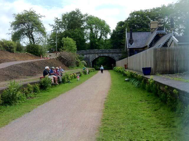
1 Title. Distance Place OS Map OS 119 Monsal Trail 1-4 Miles Nr. Bakewell Buxton & From Bakewell, Hassop 1 6 Km. Matlock The Monsal Trail is a traffic free route for walkers, cyclists, horse riders and wheelchair users through some of the Peak District s most spectacular limestone dales, and is the former Midland Railway line running for 8.5 miles between Blackwell Mill, in Chee Dale and Coombs Road, at Bakewell. Most of the route was opened to the public in 1981 but four former railway tunnels had to remain closed due to safety reasons, until 2011 when the four railway tunnels - Headstone Tunnel, Cressbrook Tunnel, Litton Tunnel, Chee Tor Tunnel where opened for trail users. Each tunnel is about 400 metres long and will be lit during normal daylight hours. Two shorter tunnels Chee Tor No.2 and Rusher Cutting already formed part of the Monsal Trail. The public can now experience the full length of the former railway route at their own pace and see breathtaking views at places like Water-cum-Jolly Dale that have remained hidden since the railway closed in This section of the walk is from Bakewell Station or Hassop Station covering Coombs Road Viaduct to Monsal Head. See the rest of the Monsal Trail from Millers Dale Station. Also for information see the website - Facilities Along the trail are many villages, Public Houses, Inns and Cafes which are close by but see the map as there are only 3 places in this part of the walk to park for wheelchair entry / exit to the trail, at the following locations - At Bakewell Station Park at the old Bakewell Station. or park on the road / lanes nearby. Hassop Station There is a pay and display car park at the Hassop Bookshop & Café at the side of the Trail. Near Great Longstone You can get on / off the trail at the old Gt. Longstone Station near Thornbridge Hall but you will have to be picked up / dropped off as there are only a few spots to park on the narrow roadside. See the walk leaflet / location Map Café There are numerous cafés and local inns in the villages close by. But on the trail there is the Hassop bookshop, cycle hire and café selling excellent food. Also off the trail at the Monsal Head Hotel there is the Stables restaurant and café also Ellerys Café.

2 Hassop Station, Cycle Shop & Café Toilets Toilets can be found on the trail at Bakewell Station and Hassop Station café. Path The length of the trail is quite flat and is made up of fine rolled-in crushed stone, with tarmac in some tunnels and suitable for all wheelchairs. You will need to choose the section to walk as wheelchair and mobility scooter users can only access the trail through accessible places at the old Bakewell Station, Hassop Station, Great Longstone Station and Millers Dale Station. There are quite a few stretches where you are limited to a view as you are in railway cuttings. There is also a spectacular view of the Monsal Head viaduct and valley below from the Monsal Head Hotel which is shown in the photo gallery. For walkers you can use other paths to combine the Monsal Trail into a round walk.

3 Crushed Stone Path See the Gallery for more photos Information There is excellent information on the Monsal Trail website and at Bakewell Tourist Information Office and at the Hassop cycle shop. Tel. No. Bakewell Tourist Iinformation Office Hassop bookshop / café Website Monsal Trail Monsal Trail Hassop Station Café - Directions Bakewell is close to the M1 and about 12 miles West of Chesterfield on the A619 through Baslow to Bakewell, look for a left to Bakewell Station. To get to the old Hassop Station take the A619 towards Baslow and look for a left to Hassop on the B6001 the Hassop station bookshop is first left on the round a bout. The Great Longstone Station entry / exit location at Thornbridge Hall is close to Great Longstone see the maps for directions.


4 Places to visit nearby Bakewell - Baslow to Chatsworth walk Edensor to Chatsworth walk Chatsworth House Chatsworth Farm Shop Millers Dale Baslow Rowsley - Longshaw Lodge Estate walk. Monsal Trail Bakewell Station
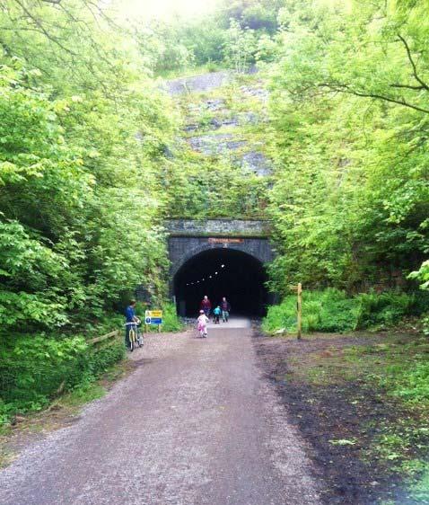
5 Thornbridge Station Headstone Tunnel


6 Monsal Head Viaduct Monsal Head View

7 View of Viaduct from Monsal Head Hotel
YHA RAVENSTOR Ideas for walks in the local area
 YHA RAVENSTOR Ideas for walks in the local area How to use this book This book contains some suggestions for enjoyable walks in the countryside immediately surrounding YHA Ravenstor. We hope that our guests
Derbyshire Dales Walking for Health Guide January March Improve Your Health Explore The Dales Enjoy The Company Get Active
 Improve Your Health Explore The Dales Enjoy The Company Get Active Derbyshire Dales Walking for Health Guide January March 2017 1 A programme of led walks across the Derbyshire Dales, supporting local
Derbyshire Dales Walking for Health Guide January to March Improve Your Health Explore The Dales Enjoy The Company Get Active
 Improve Your Health Explore The Dales Enjoy The Company Get Active Derbyshire Dales Walking for Health Guide January to March 2018 A programme of led walks across the Derbyshire Dales, supporting local
Derbyshire Dales Walking for Health Guide April to June Improve Your Health Explore The Dales Enjoy The Company Get Active
 Improve Your Health Explore The Dales Enjoy The Company Get Active Derbyshire Dales Walking for Health Guide April to June 2018 A programme of led walks across the Derbyshire Dales, supporting local communities
Tideswell to Castleton
 Tideswell to Castleton 1 Walk summary Length: 14 km, 8.5 miles Maps: OS Explorer OL1 The Peak District - Dark Peak Area, OS Explorer OL24 The Peak District - White Peak Area, OS Landranger 110 Sheffield
On the 3 rd June 2013, Cosima Towneley opened Peak Horsepower s Kinder Loop at The No Car Café at Rushop Hall.
 Newsletter Issue 8 October 2013 In this issue: Wigley Lane repaired TRO for Roych and Long Causeway Hope Ride Another loop Diary dates: 25 October Consultation closes on Cherpit Lane 19 November AGM at
EVENT GUIDE. Chatsworth Sunday 9 July
 EVENT GUIDE Chatsworth Sunday 9 July WELCOME Thank you for entering VitalityMove! I am so excited to be involved in the first event at Chatsworth House and am planning on running the Disney Music Mile
F R E E R E s E R v o i R WA L K s REsERvoiR WALKs To BLoW AWAY THE CoBWEBs BRougHT To You BY
 F R E E r e s e r v o i r WALKS reservoir WALKS TO BLOW AWAY THE COBWEBS Brought to you by Only available in Yorkshire. We look after 72,000 acres of land in Yorkshire, spanning the North York Moors, the
Masson Hill. Walk. Approximately 4 km. Moderate Walk Begins from Matlock Railway Station
 Masson Hill Walk Approximately 4 km Moderate Walk Begins from Matlock Railway Station TOWN WALKS Masson Hill walk is approx. 4 km. It can be walked in a couple of hours or so. Enjoy your walk and the beautiful
Lincolnshire Walks. Ancaster. Three cir cular walks of2 3/4,4or 6km (11/3, 21/2 or 33/4 miles)
") Lincolnshire Walks Ancaster Three cir cular walks of2 3/4,4or 6km (11/3, 21/2 or 33/4 miles) Introduction These walks are set in the attractive countryside around the historic town of Ancaster. The town
Lincolnshire Walks Ancaster Three cir cular walks of2 3/4,4or 6km (11/3, 21/2 or 33/4 miles) Introduction These walks are set in the attractive countryside around the historic town of Ancaster. The town
C: Course Details. Course Name Circuit of Chelmorton, Flagg & Monyash for the High Peak Road Race
 C: Course Details Course Name Circuit of Chelmorton, Flagg & Monyash for the High Peak Road Race Course Description The Riders will ASSEMBLE at 10.00 am promptly outside the Chelmorton Institute, Main
Although the majority of these walks are around country lanes you should still follow the Country Code:-
 With the update of the Parish Plan was a request for details of any Walks around Pillaton The following pages give several walks that I and my wife have done for many years. Please be aware that NONE OF
Thornton le Dale Walks
 Thornton le Dale Walks A collection of walks in and around the village Thornton le Dale Traders Forum www.visitthorntonledale.co.uk Thornton le Dale Walks Walk 1: Beck Isle Cottage and All Saints Church
This walk description is from happyhiker.co.uk
 This walk description is from happyhiker.co.uk Pendle Hill Walk From Barley Starting point and OS Grid reference Ordnance Survey map Distance Traffic light rating Barley village honesty box car park OS
THE FIRST MOUNTAIN BIKE TRAIL CENTRE IN THE GCC & MIDDLE EAST
 THE FIRST MOUNTAIN BIKE TRAIL CENTRE IN THE GCC & MIDDLE EAST INTRODUCTION WELCOME TO HATTA TRAIL CENTRE WEBSITE Hatta Trail Centre is a first MTB Centre in the Middle East, and is a home to multiple cross
Parkside Classic Run
 Parkside Classic Run 17th June 2018 Final Instructions Dear Entrant Hello and welcome to the pre-amble to the 2018 Crooked Spire Classic Parkside Run. As always we are keeping fingers crossed for good
Didcot Urban Race 2014
 Thames Valley Orienteering Club Didcot Urban Race 2014 UK Urban League, Southern England Urban League & British Orienteering Rankings Monday 25 th August 2014 Key Points Race HQ at Willowbrook Leisure
Walk 7: Watchet to washford
 Walk 7: Watchet to washford Length: Moderate - 7.5 miles / 12 km Good For: Theme: History Duration: 2-3 hours depending on speed of walking Notes: This is a moderate to difficult walk in places, with steps,
Walk 2: Beamsley Beacon and Bolton Abbey
 Walk 2: Beamsley Beacon and Bolton Abbey Start and Finish: The Memorial Hall, Main Street, Addingham, LS29 0LZ, SE 079 497 The shortest walk is about 5½ miles (8.8km) The medium Walk is about 8¼ miles
Thornton le Dale Walks
 Thornton le Dale Walks A collection of circular walks in, and around, the village www.visitthorntonledale.co.uk Thornton-le-Dale Traders Forum and Thornton le Dale Parish Council 1 Thornton le Dale Circular
EuroVelo Overview Route Database
 EuroVelo Overview Route Database European Cyclists Federation Jesús Freire, Project Officer, j.freire@ecf.com 13 March 2017 ECF gratefully acknowledges financial support from the European commission. Nevertheless
Sandilands to Huttoft Bank
 Coastal Country Park Walks Sandilands to Huttoft Bank A CIRCULAR WALK OF 11KM (7 MILES) INTRODUCTION The Lincolnshire Coastal Country Park lies between Sandilands, Chapel St Leonards and Huttoft on the
Bonnie Prince Charlie Walk
 Bonnie Prince Charlie Walk A waymarked route from Ashbourne to Derby to celebrate the 60th anniversary (1995) of the formation of the Ramblers' Association. This route follows the general direction of
McIvor Highway Junortoun road safety issues November 2017
 McIvor Highway Junortoun road safety issues November 2017 Discussion paper, prepared by Junortoun Community Action Group Inc. for community meeting with VicRoads 16 November 2017 About this document This
Chichester Harbour. A Walker s Guide
 A Walker s Guide - Chichester Harbour Chichester Harbour A Walker s Guide Chichester Harbour is an Area of Outstanding Natural Beauty on the south coast of Britain. Virtually flat with far reaching sea
Greenwood. Walks. Cossall Canal Walk. Cossall Canal Walk
 Cossall Canal Walk C5 Cossall Canal Walk C5 Features: Cossall is a picturesque, relatively unspoiled village on the Nottingham canal, four miles south-east of Eastwood. Architecturally interesting. See
Danbury Words and pictures by Laurie Page of the Public Rights of Way team at Essex County Council.
 Danbury Words and pictures by Laurie Page of the Public Rights of Way team at Essex County Council. An undulating walk from Danbury village to the bluebells at the National Trust property of Blakes Wood.
Walk Description. Directions
 Title: Saffron Trail: Battlesbridge to Chelmsford Distance: 14¾ miles Time taken: 6 hours Start Point: Outside the Barge Inn, Battlesbridge OS Explorer Map: 175 & 183 Grid Ref.: TQ 780 947 Transport: Rail:-
Improving Thetford Cycling Provision. In and Around Thetford
 Improving Cycling Provision In and Around Thetford Presentation to Thetford Town Council July 2015 About Me Lecturer in Mathematics at the University of East Anglia Keen recreational cyclist Volunteer
Birches Valley Forest Centre is located in the heart of Cannock Chase Forest between Stafford, Cannock and Rugeley in Staffordshire, England.
 Birches Valley Forest Centre Introduction The Forestry Commission is the biggest provider of outdoor recreation in the UK and aims to offer quality woodland access to the widest range of visitors as possible.
Join the Diabetes Research & Wellness Foundation and Ramblers Countrywide Holidays as we explore the rolling hills, rural idyll, wildlife and
 Active with Diabetes Walking Holiday 2015 Sunday, 3 rd Friday, 8 th May Join the Diabetes Research & Wellness Foundation and Ramblers Countrywide Holidays as we explore the rolling hills, rural idyll,
RANS WOOD WALK circa 3 miles/ 5 kilometres
 RANS WOOD EXCURSION This walk is about an hour. It is rarely frequented by tourists or by visitors to the National Park. It is a secret favourite amongst local dog walkers and cyclists. The walk is in
Rights of Way Improvement Plan Funding Programme (RFP) 2016/17
 2016/17") Rights of Way Improvement Plan Funding Programme (RFP) 2016/17 Summary Report This report about the Rights of Way Improvement Plan Funding Programme (RFP) 2016/17, has two main purposes. It summarises
Rights of Way Improvement Plan Funding Programme (RFP) 2016/17 Summary Report This report about the Rights of Way Improvement Plan Funding Programme (RFP) 2016/17, has two main purposes. It summarises
Must Tri Harborough Try-a-Tri and Sprint Triathlon
 Must Tri Harborough Try-a-Tri and Sprint Triathlon Provisional Race Information Market Harborough Leisure Centre, Northampton Road, Market Harborough, Leicestershire, LE16 9HF Sunday 7th September 2014
Bakewell Club Site - Robin Hood's Stride
 Bakewell Club Site - Robin Hood's Stride Camping and Caravanning Route Summary A circular walk with fabulous views winding it's way through the beautiful White Peak scenery. Points of interest include
Hammer Vale and Linchmere Common
 point your feet on a new path Hammer Vale and Linchmere Common Distance: 9 km=5½ miles or 6 km=3¾ miles easy walking with one steep section Region: Hampshire, West Sussex Author: Botafuego Refreshments:
Gainsborough and Fledborough Circular
 Trent Vale Cycle Route TVCR18 Gainsborough and Fledborough Circular Gainsborough Old Hall. One of the biggest and best preserved Medieval Manor Houses in England. Start Point: Gainsborough Marshall s Yard
Two Tunnels Railway Races Event Information
 Two Tunnels Railway Races Event Information Important Notices Brickfields Park, Bath, BA2 1LX 18th Feb, 09:20am There is no on street parking available for runners on the streets around Brickfields. Please
Question 14 Landscape and nature:
 Question 14 Landscape and nature: Do you think that we need any more footpaths or changes to existing ones? Please specify. [Written responses to the please specify question are recorded with abbreviations
Greenway. Great Western A USER S GUIDE. Ireland s Longest Off-Road Walking And Cycling Route.
 Great Western Greenway www.greenway.ie A USER S GUIDE Ireland s Longest Off-Road Walking And Cycling Route EUROPEAN DESTINATION OF EXCELLENCE AWARD WINNER t o Escape the bustle of urban life on the 42km
The Hundred Parishes
 The Hundred Parishes Walks from railway stations number 9 6.4 miles (10kms) from Bishop s Stortford to Stansted Mountfitchet Start: Bishop s Stortford station (Grid Reference TL492209) (ample parking and
Access Statement for RSPB Lake Vyrnwy
 This access statement does not contain personal opinions as to our suitability for those with access needs, but aims to accurately describe the facilities and services that we offer all our guests/visitors.
River and Canal Maps
 River and Canal Maps for Trent Adventure Trent Adventure Base at Poplars Farm Twyford Road Twyford Barrow or Trent DE73 7HJ 07876 751 599 28-Apr-2015 2015 Trent Adventure - Version 3p4 1 Trent and Mersey
8 Miles Circular 4 hours
 VISIT RYEDALE HELMSLEY AND RICCAL DALE 8 Miles Circular 4 hours 090616 Challenging Terrain An 8 mile (13km) circular walk from the market town of Helmsley in Ryedale. The route heads out across sheep pastures
ST. AGNES. Blackwater G C. walk number
 Blackwater walk number 10 Blackwater can be approached from various directions but most easily from the A30 at Chiverton Cross roundabout. Take the exit signed to Blackwater. Pass the filling stations
& r al. Two circular walks of 8 km (5 miles) wal k
 wal k") & Ru r al Two circular walks of 8 km (5 miles) s ford Riv m a t S er wal k Introduction Stamford is noted as being one of the finest stone towns in the country. The stone being local limestone and Collyweston
& Ru r al Two circular walks of 8 km (5 miles) s ford Riv m a t S er wal k Introduction Stamford is noted as being one of the finest stone towns in the country. The stone being local limestone and Collyweston
10Km Road Race - Race Day Info Sheet
 Denmead Striders Running Club 10Km Road Race - Race Day Info Sheet Sunday 14 th October 2018 at 10:00am (UKA Licence No: 2018-33481) Thank you for entering the fifth running of the Denmead 10km Road Race
Ambergate & Betty Kenny's Tree.
 Walk Information Walk Area: Ambergate OS Map: Explorer OL24 Distance: 4 Miles White Peak Area Start Point: Holly Lane, Ambergate 1:25000 Map Ref: SK 346 254 Post Code N/A General Information Altitude Data
3rd GRADE MINIMUM CONTENTS UDI 2: WHERE WE LIVE (6)
") 3rd GRADE MINIMUM CONTENTS UDI 2: WHERE WE LIVE (6) POPULATION Population means all the people, or inhabitants of a village, a city or a whole country. The population of a place increases when: a. More
3rd GRADE MINIMUM CONTENTS UDI 2: WHERE WE LIVE (6) POPULATION Population means all the people, or inhabitants of a village, a city or a whole country. The population of a place increases when: a. More
A Walk around Holmes Chapel starting & finishing at Holmes Chapel Railway Station. by Tony & Lindsay Wright (2016)
") A Walk around Holmes Chapel starting & finishing at Holmes Chapel Railway Station. by Tony & Lindsay Wright (2016) Introduction Holmes Chapel Railway Station is on the Crewe to Manchester line. The station
A Walk around Holmes Chapel starting & finishing at Holmes Chapel Railway Station. by Tony & Lindsay Wright (2016) Introduction Holmes Chapel Railway Station is on the Crewe to Manchester line. The station
Welsh Newton and Woodland
 Welsh Newton and Woodland This is a 8.2km miles (approx) walk which will take about 2.5 hours at a relaxed and leisurely pace. There are a few hills but no steep inclines. Start at Llangrove bus stop and
distance 96km (60m) easy
 easy") Experience Rating easy distance 96km (60m) Cycling route: 96km (60 miles) Cycling in: The Great Waterway, Stormont, Dundas and Glengarry Number of days cycling: 2 Recommended number of nights stay: 2 Experience
Experience Rating easy distance 96km (60m) Cycling route: 96km (60 miles) Cycling in: The Great Waterway, Stormont, Dundas and Glengarry Number of days cycling: 2 Recommended number of nights stay: 2 Experience
What s the difference?
 Village, Town, City My old station has been converted into a family home and my old railway line has been taken up to make room for a nature trail. I have several supermarkets and a street market twice
A27 Worthing and Lancing: facilities for walking, cycling, and horse riding [nonmotorised
 A27 Worthing and Lancing: facilities for walking, cycling, and horse riding [nonmotorised users (NMUs)] Introduction This note describes our understanding of the needs of Non-Motorised Users (NMUs) as
Weatherman Walking Sully to Penarth Approximate distance: 5 miles End Start
 Approximate distance: 5 miles For this walk we ve included OS grid references should you wish to use them. 4 End Start 2 3 N W E 1 S Reproduced by permission of Ordnance Survey on behalf of HMSO. Crown
Derwent Valley Cycleway
 Derwent Valley Cycleway 1 Introduction 1.1 Derwent Valley Trust. This document has been written by the Derwent Valley Cycleway Working Group, a sub group of the Derwent Valley Trust. The Trust is a registered
Chapel Point to Anderby Creek
 Coastal Country Park Walks Chapel Point to Anderby Creek A CIRCULAR WALK OF 8.5 OR 6 KM (5.3 OR 3.75 MILES) INTRODUCTION The Lincolnshire Coastal Country Park lies between Sandilands, Chapel St Leonards
The Mendip Way. Route Directions and Maps Wells to Frome
 The Mendip Way Route Directions and Maps Wells to Frome Website: www.mendiphillsaonb.org.uk Email: mendip@mendiphillsaonb.org.uk Facebook & Twitter: @MendipHillsAONB Phone: 01761462338 1 Wells to Shepton
WALK WELL IN TAUNTON AND WELLINGTON WINTER 2018/2019
 WALK WELL IN TAUNTON AND WELLINGTON WINTER 2018/2019 walkwellwithtone.btck.co.uk Walk Well Taunton Deane WHAT IS A HEALTH WALK? It s a brisk walk done on a regular basis for well-being. It can help you
10 Miles Circular 5 hours
 VISIT RYEDALE PICKERING AND CAWTHORN CAMPS 10 Miles Circular 5 hours Moderate Terrain 120616 A 10 mile (16km) there and back walk from the market town of Pickering in Ryedale. The route heads north through
Getting to know the Weser River in a sporty pace
 Weser: Hann. Münden - Bremen, sportive TOUR DESCRIPTION Getting to know the Weser River in a sporty pace Let the Weser take you on an especially pleasurable bike trip! Follow the river on the most worthwhile
Chartwell Access Statement
 Chartwell Access Statement Mapleton Road, Westerham, Kent, TN16 1PS T: 01732 868381 E: chartwell@nationaltrust.org.uk Introduction 1. Chartwell was the family home of Sir Winston Churchill, and is presented
2017 MATLOCK TOP 10 ROAD BOOK
 2017 MATLOCK TOP 10 ROAD BOOK The Matlock Top 10 takes place on Sunday 15/10/2017 and is returning to its original 'home' being The Whitworth Centre in Darley Dale near Matlock. This guide/road book will
ADVICE ON Multi-user Routes
 ADVICE ON 2 BHS Statement The majority of off-road routes could and should accommodate all non-motorised vulnerable road users equestrians, cyclists, pedestrians and mobility buggy users and therefore
East Lulworth Ride Route 5
 East Lulworth Ride Route 5 Out of ar Experience - ycling in Purbeck ircular route from Wareham to Lulworth - 18 miles + Lulworth ove oombe Keynes River Frome Time needed: 3-4 hours + Grading: Moderate
T H E S A I N T S W A Y ST. AUSTELL RUNNING CLUB THE SAINTS WAY RELAY SUNDAY 27 TH MAY 2018
 The annual Saints Way relay will take place on Sunday 27 th of May. For those who haven t done this before, it is something different from normal training or racing. It gives a chance to run socially and
WETHERBY CIRCULAR by Tania Dickinson
 WETHERBY CIRCULAR by Tania Dickinson This walk in lower Wharfedale includes a disused railway line at the beginning and riverside at the end, with parkland, fields, woodland and villages in between. Distance
For more information and to buy this book click here ISBN: CICERONE. Guides for walkers, trekkers, mountaineers, climbers and cyclists
 For more information and to buy this book click here ISBN: 9781852845377 CICERONE Guides for walkers, trekkers, mountaineers, climbers and cyclists www.cicerone.co.uk WALK 5 Ouston and Urpeth Distance
Heartwood Forest, in Sandridge, Hertfordshire, is a place where everyone can find space, peace, wildlife and miles of beautiful woodland to explore.
 Heartwood Forest Accessibility Statement September 2016 Purpose: This accessibility statement outlines the available facilities and access information for Heartwood Forest. Welcome We, the Woodland Trust,
Saltholme wildlife reserve and discovery park Access Statement
 This access statement does not contain personal opinions as to our suitability for those with access needs, but aims to accurately describe the facilities and services that we offer all our guests/visitors.
Grimentz-St-Luc, Switzerland. Essential Facts. Two attractive traditional villages set in the lovely valley of Val d Anniviers
 Grimentz-St-Luc, Switzerland Essential Facts Two attractive traditional villages set in the lovely valley of Val d Anniviers High altitude at 1600m with snow sure skiing up to 2900m Easy access to all
Healthy and Environmental Friendly Transport in the City Region
 Healthy and Environmental Friendly Transport in the City Region Reindert Augustijn Team manager traffic and transport Arnhem Nijmegen City Region www.polisnetwork.eu/2014conference #polis14 Fact and figures
Bikers. Guide to Derbyshire. The. Essential rider information DERBYSHIRE ROAD SAFETY PARTNERSHIP
 The Bikers Guide to Derbyshire Essential rider information DERBYSHIRE ROAD SAFETY PARTERSHIP Contents Get ready for Derbyshire roads -3 Smash hits your guide to Derbyshire s biker hotspots A50 Via Gellia
Husthwaite to Byland Abbey
 Husthwaite to Byland Abbey This walk begins with a loop round the village of Husthwaite and continues towards Coxwold along a disused railway line, which is now a right of way. It passes through Coxwold
Waterhead Pier to Orrest Head, Windermere and Bowness
 Waterhead Pier to Orrest Head, Windermere and Bowness A 4 1 2 hour walk through Woodlands and the Troutbeck Valley with spectacular Lake and Mountain views and a lakeshore path. Walk 10 Walk 11 Walk 12
City of Wells Cycle Network
 City of Wells Cycle Network National Cycle Network Routes 26 and 3 through Wells City Centre National Cycle Network Routes 26 and 3 Tor Furlong Perimeter Route Wells City Links Existing Dulcote Path Coxley
Fertile farms in the heart of Kent
 55 55 Fertile farms in the heart of Kent A bright sunny day is perfect for enjoying the rich and fertile Kent countryside and outstanding views across the valley of the Great Stour to the North Downs.
wodonga PATHWAYS Connecting you to health and activity
 wodonga PATHWAYS Connecting you to health and activity CONTENTS SAFETY TIPS 7 BIKE HIRE 8 GATEWAY ISLAND/BELVOIR PARK 10 TRAIN STATION LINK/HOUSE CREEK 12 LOGIC LOOP/WEST WODONGA 14 BIRALLEE PARK 16 FELLTIMBER
Yorkhill & Kelvingrove Community Council Cycling Village Proposal. Yorkhill Kelvingrove Cycling Village (1.3)
") Yorkhill Kelvingrove Cycling Village (1.3) 1) Introduction In recent years our community has been transformed. We have seen additional student and residential accommodation constructed. The redevelopment
Yorkhill Kelvingrove Cycling Village (1.3) 1) Introduction In recent years our community has been transformed. We have seen additional student and residential accommodation constructed. The redevelopment
GROUP PRE-VISIT GUIDE
 GROUP PRE-VISIT GUIDE Helpful Reminders LUNCH If your group is bringing bagged lunches Reservations in the School Lunchroom are required ($15 flat fee) if your group is bringing bagged lunches. Please
Dyrham and Hinton Parish Walks
 Dyrham and Hinton Parish Walks A series of five walks in the parish, exploring most of the public footpaths. By John Miller Each walk is described in detail, with a complete map, to provide a handy guide
THE BECK STONE Backstone Beck on Ilkley Moor
 THE BECK STONE Backstone Beck on Ilkley Moor 1 Three different routes which take in the best of the lower slopes of Ilkley Moor, with bracken, heather, a tarn (a small mountain lake) and rushing streams.
OLDER PEOPLE INDEPENDENT MOBILITY FOR LIVEABLE COMMUNITIES. Christopher G B (Kit) Mitchell
 Mitchell") OLDER PEOPLE INDEPENDENT MOBILITY FOR LIVEABLE COMMUNITIES by Christopher G B (Kit) Mitchell Independent mobility is necessary for a high quality of adult life In developed countries, the automobile has
OLDER PEOPLE INDEPENDENT MOBILITY FOR LIVEABLE COMMUNITIES by Christopher G B (Kit) Mitchell Independent mobility is necessary for a high quality of adult life In developed countries, the automobile has
PAGHAM NEIGHBOURHOOD PLAN INFRASTRUCTURE GROUP
 PAGHAM NEIGHBOURHOOD PLAN INFRASTRUCTURE GROUP SUMMARY OF FINDINGS AND PRIORITIES PARKING There was a high level of response to this topic which included many aspirations to provide car parking near to
The Fallowfield Loop. Part of the Manchester Cycleway. 3rd edition
 The Fallowfield Loop Part of the Manchester Cycleway 3rd edition What is the Fallowfield Loop? The Fallowfield Loop is an old railway track built and maintained by the national charity Sustrans (www.sustrans.org.uk),
1. Kala Nera Milies Kala Nera
 1. Kala Nera Milies Kala Nera A beautiful and varied walk from Kala Nera, a tourist seaside village, to Milies which lies 400 metres higher up. From there it proceeds back down to Kala Nera along another
9.5 km Circular 3 hours
 RANMORE CIRCULAR A 6 mile (9.5km) circular walk from Boxhill and Westhumble Station in the village of Westhumble, passing through part of the Polesden Lacey Estate, Ranmore Common and Denbies Vineyard.
Rhossili - Tears Point - Mewslade Bay - Talgarth's Well - Rhossili - ID: 148. Walk description:
 Walk description: A glorious walk combining thrilling cliffs with beautiful wild beaches and a bird's-eye view of the Gower peninsula from Rhossili Down. The adventurous can walk out to the Worm's Head
Skyline 10km Series Race Information 15th November, 6th December, 17th January, 14th February 11:00am Start University of Bath, Bath, BA2 7JY.
 Skyline 10km Series Race Information 15th November, 6th December, 17th January, 14th February 11:00am Start University of Bath, Bath, BA2 7JY. Important Notices New Location We are now in West Car Park!
UCI Wiggle Magnificat Newbury Racecourse Sunday 3 rd June 2012 Rider Information Brief
 UCI Wiggle Magnificat Newbury Racecourse Sunday 3 rd June 2012 Rider Information Brief 1. Welcome! Ken and Barbara Robson and our support team welcome you to the coming weekend at Newbury Racecourse and
Weatherman Walking. Approximate distance: 5.5 miles For this walk we ve included OS grid references should you wish to use them. Start.
 Approximate distance: 5.5 miles For this walk we ve included OS grid references should you wish to use them. 4 1 Start End 3 2 N W E S Reproduced by permission of Ordnance Survey on behalf of HMSO. Crown
Bike Mount. the Green Net PARK2PARK. SAFE, SEPARATE and ACCESSIBLE Walk/Cycleways. Tauranga CONNECT GREEN LINE - Vision WAIMAPU ESTUARY
 the Green Net 2 Bike Mount SAFE, SEPARATE and ACCESSIBLE Walk/Cycleways Tauranga CONNECT GREEN LINE - Vision 2017-2020 Improve the quality of life for people in Tauranga City and Region by bringing citizens
Where did it all go wrong, George?
 Where did it all go wrong, George? Those readers of a certain age will recognise the above quotation. Uttered by the waiter on room service, as he entered George Best s hotel bedroom, to see him in bed
Bedminster and Southville
 Issue 51 Bedminster and Southville Free Walks Programme - Sept to Nov 2016 & Photo taken by Ruth Mor- Between 30-60 minute walks Between 2-3 miles - up to 90 minute walks The Walks are led by qualified
VELINDRE VALLEYS WALK FOR STEFFAN
 VELINDRE VALLEYS WALK FOR STEFFAN IMPORTANT INFORMATION FOR WALKERS AND MARSHALS 1 Table of Contents Key Contact Numbers:... 3 Timetable and locations... 4 T-shirts... 4 Important Advice for Walkers...
December 2014 Newsletter
 PDGLA PO Box 7976 Great Longstone, Bakewell, Derbyshire, DE45 9AY Web: www.pdgla.org.uk Email: pdgla@hotmail.co.uk December 2014 Newsletter Good news - Black Harry Lane is a Bridleway Black Harry Lane,
10 km Circular 3 hours
 FRIMLEY AND FRIMLEY GREEN 10 km Circular 3 hours Easy Terrain 250716 A 10km (6 mile) circular walk exploring the canal towpath, riverside path, woodland, heath and small settlements around Frimley in Surrey.
THE WELLDIGGERS ARMS, HESWORTH AND FITTLEWORTH TRAIL
 THE WELLDIGGERS ARMS, HESWORTH AND FITTLEWORTH TRAIL 5.5 miles Circular 3 hours 041017 Challenging Terrain A 300-year-old pub turned country-inn on the edge of the South Downs National Park, The Welldiggers
Karangahape Road Streetscape Improvement Project: Feedback from Myers Park Medley
 Percentage of submitters mentioning theme Karangahape Road Streetscape Improvement Project: Feedback from Myers Park Medley The Karangahape Road Streetscape Improvement Project Team set up a display at
Redesdale Arms. A Trio of Walks
 Redesdale Arms A Trio of Walks Welcome to The Redesdale Arms Hotel The award winning 34 bedroom Redesdale Arms Hotel sits at the gateway to the Cotswolds in the High Street of the historic town of Moreton-in-Marsh.